
International Research Journal of Engineering and Technology (IRJET) e-ISSN:2395-0056
Volume: 12 Issue: 06 | Jun 2025 www.irjet.net p-ISSN:2395-0072
International Research Journal of Engineering and Technology (IRJET) e-ISSN:2395-0056
Volume: 12 Issue: 06 | Jun 2025 www.irjet.net p-ISSN:2395-0072
Ayushi Sharma1, Dr. Kh. Moirangleima2
1Research Scholar, School of Earth Sciences, Department of Geography, Banasthali Vidyapeeth, Rajasthan, INDIA
2 Assistant Professor, School of Earth Sciences, Department of Geography, Banasthali Vidyapeeth, Rajasthan, INDIA ***
ABSTRACT- Lucknow city as a geographical entity is one of the most important administrative and political unit for Uttar Pradesh as well for North India. Being at the centre of the most populous state of India it enjoys the status of capital city of Uttar Pradesh. The aim of the research paper is to study the expansion of Lucknow city in relation to the growth in its population from 1981-2021. The population statistics increased from 1007604 in 1981 to 2880108 in the year 2011. Area of Lucknow Urban Agglomeration in the year 1987 was 9170.00 hectares which has increased to 24481.57 hectares in the year 2010 to 2011. Present research work is based on data collected from census reports, Master Plans published by Lucknow Development Authority (LDA) and published- unpublished research papers. Lucknow city base map has been developed with the Arc GIS software 10.2.
Key Words: Lucknow city, population statistics, Land use, urban expansion, Arc GIS
ExpansionofcitiesistheageofmodernIndia. UrbanpopulationofIndiahasescalatedfrom19.8millionintheyear1981 to 377 million in the year 2011 (City Development Plan, 2006). Eventually, increase in demographical statistics directly caused the cities to expand as to provide satisfactory facilities to its residents. With an increase in population need of residential areas, parks, recreational areas, industrial areas, development of transportation routes came forward which ultimatelyleadstotheurbanareaexpansion(Patel,U.B.andTeli,B.L.,2019).Lucknowisamongthefastestgrowingcityof northIndia.Beingthecapital ofone ofthemostpopulated states;UttarPradesh,Lucknowhasalways beenthecenterof development from the time immemorial. As the growth of urbanization has led to the rapid growth of Indian cities, Lucknow city is no exception. Study of land use is essential part of studying growth pattern of any city. Land use in common term can be defined as the use of land by human being for different purposes. Thus, with the help of land use pattern and population statistics, expansion of cities can be studied up to some extent (Lucknow Municipal Corporation, 2015) Skog, Kristine Leig, Steinnes, Margrete, (2016) studied that the rate of rapid population growth and urbanizationresultsindecliningfarmlandsinNorway.ThestudyrevealsthepercapitaavailabilityoffarmlandinNorway is 0.2 hectares while rate of food supplied is less than 50 percent, lower than the avergae OECD countries. Present condition raises the concern of conversion of farmlands into built-up areas due to increase in the rate of population and migration Chhangani, Chandra Shekhar, (2023) elaboratesontheurbansprawlanditsimpactinIndiawiththehelpof case studies of Ahmedabad, Chennai, Surat and Pune. It is seen that urban sprawl results into increased infrastructural cost, high service expenses, hike in transportation costs, decline agricultural productivity etc. Integrating planned urban developementstrategies,developmentofgreenspaces,temporalmonitoringofurbansprawlanditspreventionwhichat some point ins considered in the above mentioned cities would help in restoring sustainable urban planning of indian cities.
TheaimofthisresearchpaperistostudytheroleofpopulationintheexpansionofLucknowfrom1981-2021.
Theobjectivesoftheresearchworkaretostudy-
1. ThepopulationgrowthofLucknowcityfrom1981-2021.
2. TostudythelandusepatternofLucknowcity.
3. TostudyrelationbetweenpopulationandexpansionofLucknowcityfrom1981-2021.
The research work is analytical, descriptive and quantitative in nature. Data is primarily based on secondary sources collected from census reports 1981-2011, Master plan of Lucknow 2001, 2021 and 2031 published by Lucknow
International Research Journal of Engineering and Technology (IRJET) e-ISSN:2395-0056
Volume: 12 Issue: 06 | Jun 2025 www.irjet.net p-ISSN:2395-0072
Development Authority (LDA) and city developmental reports published by concerned government departments. LucknowcitybasemaphasbeenpreparedwiththehelpofArc GISsoftware10.2 fromcensus ofIndia,2011 Population datafortheyear1981-2021hasbeencollectedfromcensusreports1981,1991,2001,2011andMasterPlanofLucknow City2021.DataonevolutionofLucknowcityhasbeencollectedfrommasterplanofLucknowcity2001,2021and2031 Graphical representation of population data from 1981-2021. Comparison of population data with the areal statistics of Lucknowcityfrom1981-2021.
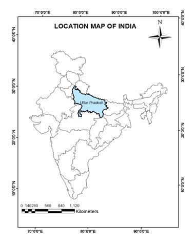
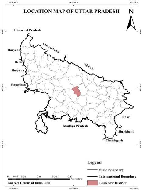
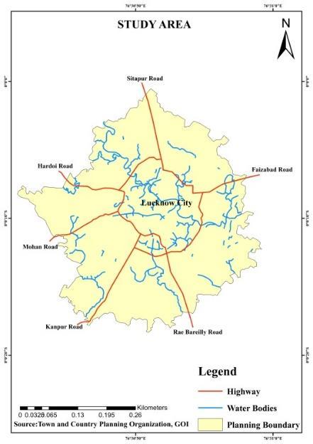
Lucknow the capital of most populous state of India i.e., Uttar Pradesh, is one of the most important cities of Northern India. It lies between 26° 30' N to 27° 10' N latitudes and 80° 30' E to 81° 13' E longitudes. The area of Lucknow city is 233,365.71sq.km. (TownandCountryPlanningOrganization,2020).Itisbounded byHardoionNorth-West, Sitapuron North, Barabanki on North-East, Rae Bareilly on South-East and Unnao district on South-west. Gomti river is the main drainagesystemofthecitywhichflowsthroughthecentreofLucknowdividingitintotwoequalhalves-TransGomtiand CISGomtiregion.ThecentrallocationofLucknowcitywithinthestategainsadministrativeandpoliticalimportance.
International Research Journal of Engineering and Technology (IRJET)
Volume: 12 Issue: 06 | Jun 2025 www.irjet.net
Lucknowcityliesinthesub-tropicalwarmandhumidclimate.JanuaryasitscoldestmonthandMayasthehottestmonth. Averagerainfall received by thecityis896.2 mm(Final report,LucknowMunicipal Corporations,2015).Lucknowcityis very well connected with major cities via. highways, railways and airways. The city is also developing as the major educationalattractionespeciallyforthecitiesbelongingfromEasternUttarPradesh.UniversityofLucknow,KingGeorge MedicalUniversity,NationalLawuniversityaresomeofthemaineducationalsitesofLucknow.
The rapid development of Lucknow city and the consequent improvement in the standard of living have resulted in a significant increase in its population. According to the provisional data from the 2011 census of India, the population of LucknowUrbanAgglomerationwasrecordedat2,880,108,reflectingaremarkabledecadalgrowthrateof28.26 percent (Census of India, Uttar Pradesh, District Handbook Lucknow, 2011) This growth can be attributed to various factors, including the capital city status of Lucknow, which offers improved employment opportunities, enhanced educational facilities,andbetterinfrastructurecomparedtoothercitiesinUttarPradesh (Kumari,Kiran,2015).Asaresult,therehas been an influx of migrants from neighbouring states, contributing to the demand for settlement areas and ultimately leadingtotheexpansionofLucknowCityintonearbyregions.(Asshownintable1below)
Table 1: PopulationStatisticsofLucknowUA1981-2021
Source- MasterPlan2031,*projectedpopulationusingCompoundAnnualGrowthRateMethod
Based on the population statistics provided in Table 1 for Lucknow Urban Agglomeration from 1981 to 2021, we can observethefollowingtrends:
PopulationGrowth:ThepopulationofLucknowUrban Agglomerationhas experiencedsignificantgrowthover theyears. From1981to2021,thepopulationhaswitnessedasubstantialincrease.
Steady Growth: The population growth has been relatively consistent, with noticeable increments during each decade.Thisindicatesasustainedexpansionoftheurbanagglomeration.
Rapid Growth Rate: The decadal growth rates demonstrate a substantial increase in population over the years. Notably,theperiodbetween1981and1991witnessedaconsiderablegrowthrate,followedbyconsistentgrowth insubsequentdecades.
International Research Journal of Engineering and Technology (IRJET) e-ISSN:2395-0056
Volume: 12 Issue: 06 | Jun 2025 www.irjet.net p-ISSN:2395-0072
Accelerated Growth in Recent Years: Thepopulationgrowthhasacceleratedinrecentyears.Between2011and 2021,therehasbeenaremarkableincrease,withthepopulationprojectedtoreach34,699,333in2021.
Significance of 2011: The year 2011 marked a significant milestone in population growth, with the population crossing the 2 million mark and reaching 2,880,108. These population trends highlight the dynamic nature of Lucknow Urban Agglomeration, with a consistent increase in population over the years. The significant growth rate underscores the need for effective urban planning, infrastructure development, and provision of essential servicestoaccommodatetherisingpopulationandensuresustainablegrowthandqualityoflife fortheresidents (Iyer,Neelkantha,Krishna,Kulkarni,Sumati&Raghavaswamy,V.,2007)
As per the Lucknow Development Authority (LDA), the 1980s and the year 2004-05 marked significant periods of expansion and development for Lucknow City. These periods witnessed notable advancements, including the establishmentoftheI.T.city,theprovisionofhousingfacilities,theformationoftheindustrialdevelopmentauthority,and the construction of Lucknow's first international cricket stadium, Ekana Stadium (Lucknow Development Authority, 2016)
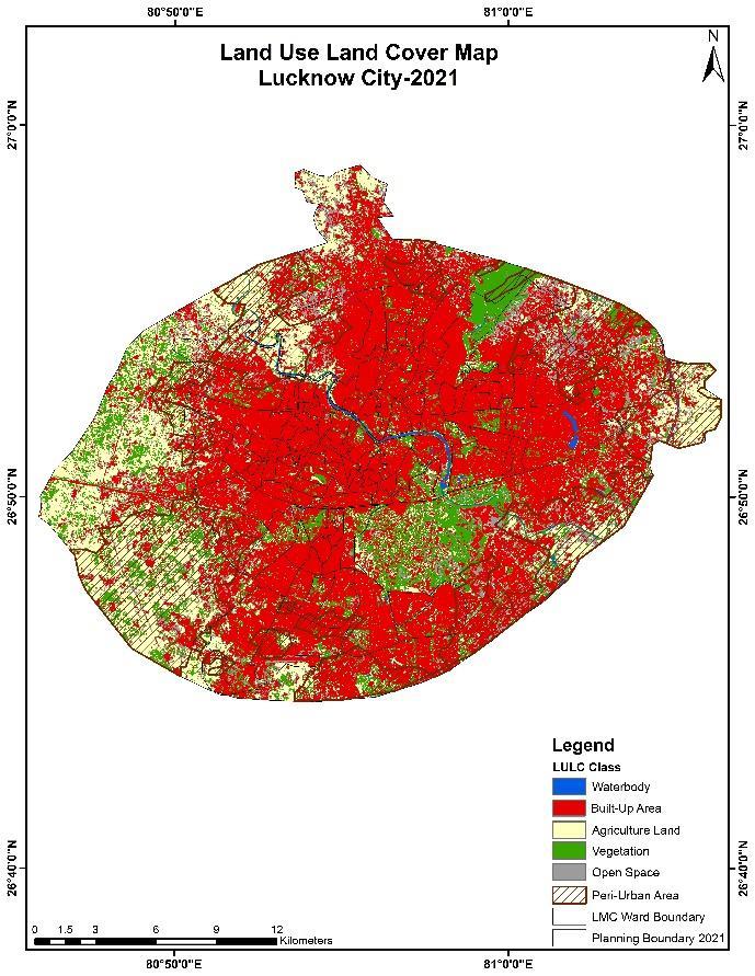
Theseinitiativesplayedacrucialroleindrivingthecity'sgrowth,particularlyinitsperi-urbanareas.Theanalysisofland use pattern is a vital aspect when studying urban expansion. It provides insights into how land is utilized for various purposeswithinthecity.InthecontextofLucknowCity,Table2presentsacomprehensiveoverviewofthegrowthofland usepatterns.
Source: MasterPlanofLucknow,2031andTownandCountryPlanningReport,2015
Volume: 12 Issue: 06 | Jun 2025 www.irjet.net
p-ISSN:2395-0072
BasedontheprovidedstatisticsinTable2showcasingthelandusepatternofLucknowCity,wecangatherthefollowing information:
Residential Land Use: TheareadedicatedtoresidentiallanduseinLucknowCitywitnessedsubstantialgrowth over the years. From 1987 to 2010-11, it expanded from 4,485.98 hectares to 10,278.68 hectares, indicating a significantincreaseinresidentialdevelopment.
Industrial Land Use: The land area allocated for industrial purposes also experienced growth, albeit at a comparatively smaller scale. Between 1987 and 2010-11, industrial land expanded from 596.22 hectares to 940.57hectares.
Office Land Use: Theareadesignatedforofficespaceswitnessedanotableincreasefrom474.69hectaresin1987 to888.76hectaresin2010-11,indicatingthegrowthofcommercialactivitiesandadministrativecentres.
Commercial Land Use: The land area designated for commercial purposes exhibited growth over the years. It expandedfrom223.77hectaresin1987to623.14hectaresin2010-11,reflectingthegrowthofbusinessactivities andcommercialestablishments.
Recreational Places: The land area allocated for recreational purposes experienced moderate growth, rising from 346.48 hectares in 1987 to 997.71 hectares in 2010-11, reflecting the importance placed on leisure and recreationalactivities.
Public Utilities: The land area dedicated to public utilities, such as infrastructure and services, witnessed substantial growth. It expanded from 902.02 hectares in 1987 to 2,137.26 hectares in 2010-11, indicating the developmentofpublicamenitiesandutilities.
Transportation: The land area allocated for transportation purposes, including roads, highways, and transportation infrastructure, exhibited significant growth. It expanded from 952 hectares in 1987 to 7,842.74 hectaresin2010-11,highlightingtheexpansionandimprovementofthecity'stransportationnetwork.
River/Water Bodies: River and water bodies remained relativelyconsistent, with a slightincreasefrom 193.66 hectares in 1987 to 578.64 hectares in 2010-11. These statistics provide valuable insights into the land use dynamics of Lucknow City, indicating the growth and development of residential, commercial, industrial, recreational, and public utility areas. The expansion of transportation infrastructure and the maintenance of waterbodiesalsoplayimportantrolesinshapingthecity'slandusepattern.
The population statistics presented in Table 1 for Lucknow Urban Agglomeration from 1981 to 2021 reveal a consistent andsignificantincreaseinpopulationovertheyears.Startingwithapopulationof1,007,604in1981,thecityexperienced steady growth, reaching 2,880,108 in 2011. Furthermore, the projected population for 2021 stands at 3,469,933, highlightingacontinuedupwardtrend.Inconjunctionwiththepopulationgrowth,Table2providesinsightsintotheland use pattern of Lucknow City from 1987 to 2010-11. Several notable trends emerge from the data. Residential land use witnessed substantial expansion, indicating the need for increased housing facilities to accommodate the growing populationresultinginshrinkinggreenbeltofLucknowcityandfurtherexpansionofcityinperi-urbanareas.
Whiledevelopmentbringsnumerousbenefits,itcanalsohaveadverseeffectsonlandandtheenvironment.Inthecaseof Lucknow City's expansion and development, there are some potential ill effects which needs to be taken into consideration. Urban development often involves land conversion from agricultural or natural areas to built-up spaces (Rawat,AshwiniKumar,Banerjee,Subhrajeet,&Roy,AnilKumar, 2020).Thiscanresultinthelossoffertilesoil,reduced biodiversity, and destruction of natural habitats, leading to land degradation. As urban areas expand, clearing forests or greenspaceshasbeenclearedtoaccommodateinfrastructureandhousingprojects.Deforestationcontributestotheloss ofvaluableecosystemsspeciallyaroundGomtiriverharmingthenaturalecologyoftheriver.Vehicleemissions,industrial activities, and improper waste management has contributed to air pollution and water contamination, which has negatively impacted human health and ecological systems. Inadequate waste management practices have resulted in development of dumping ground within and outside city area causing immense pollution, health hazards, and strain on waste disposal systems. As city expands, there is a greater demand for water supply, drainage systems, and wastewater management. Poor urban planning and inadequate infrastructure resulted in water scarcity, flooding, and pollution of waterbodiesinlow-classlocalitiesofLucknowcityandinperi-urbanareas(LucknowMunicipalCorporation,2015) International Research Journal of Engineering and Technology (IRJET) e-ISSN:2395-0056
International Research Journal of Engineering and Technology (IRJET) e-ISSN:2395-0056
Volume: 12 Issue: 06 | Jun 2025 www.irjet.net p-ISSN:2395-0072
BasedonthepopulationstatisticsandlandusepatternsofLucknowCity,areasofimprovementandpotentialsuggestions for urban development could be infrastructural development, development of affordable house particularly for poor section of the city, development of green belt, preservation of already existing open spaces, parks and enthusiastic implementation on Gomti river cleaning program, development of balanced land use focusing integrated planning are someoftheareastobefocusedonfutureprojectsoflanduseplanninganddevelopment.
LucknowCity,thecapitalofUttarPradesh,isoneofthefastest-growingsmartcitiesinIndia.With thedevelopmentofits metropolitan area, industrial zones, housing projects, and international amenities, Lucknow City has expanded its boundaries. According to a report published by the Lucknow Development Authority, the amalgamation of 176 villages into the development area of Lucknow City in 2010-2011 resulted in a significant change in land use. The land area expandedfrom9,170hectaresin1987to24,482hectaresin2010-2011.Residential areasexperienceda massiverateof expansionduringthisperiod.Theresidentiallandareaincreasedfrom4,485.98hectaresin1987to10,278.68hectaresin 2010-2011.Concurrently,thepopulationofLucknowCitygrewsubstantiallyfrom1,007,604in1981to2,245,509in2001 and further to 2,880,108 in 2011. The projected population for the year 2021 is estimated to be 3,469,933. These populationincreaseshaveledtochangesinthelandusepattern,ultimatelyresultingintheexpansionofthecity.Thedata indicatesaclearcorrelationbetweenpopulationgrowth,landusepatternchanges,andurbanexpansioninLucknowCity. Asthe populationincreases,there isa corresponding needfor residential areas,infrastructure, andamenities,leadingto theutilizationofmorelandforthesepurposes.Theexpansionanddevelopmentofthecityaimtoaccommodatetherising populationandprovideimprovedlivingconditions,employmentopportunities,andservicestoitsresidents.Thisongoing urban growth and development in Lucknow City emphasize the significance of urban planning, sustainable land management,andinfrastructureprovision.Strikingabalancebetweenurbanexpansion,preservationofnaturalresources, andenvironmentalconservationwillbecrucialtoensureawell-planned,inclusive,andsustainablefutureforthecity.
International Research Journal of Engineering and Technology (IRJET) e-ISSN:2395-0056
Volume: 12 Issue: 06 | Jun 2025 www.irjet.net p-ISSN:2395-0072
Conflict of Interest
The authors declared no potential conflicts of interest concerning the research, authorship, and/or publication of this article.
[1] CityDevelopmentPlan,(2006),GovernmentofIndia,FeedbackVenturesPvt,Ltd,August14,2006
[2] CensusofIndia,UttarPradesh,DistrictHandbookLucknow, (2011),CensusofIndia2011-UttarPradesh-Series 10 - Part XII B - District Census Handbook, Lucknow, India, 2016, Reference ID: DH_2011_0926_PART_B_DCHB_LUCKNOW,Producer(s)DirectorateofCensusOperations,UttarPradesh
[3] Chhangani,Chandra Shekhar,(2023), Urban Sprawland itsImpact:A ComprehensiveReviewinIndianContext, InternationalJournalofCreativeResearchThoughts(IJCRT),|Volume11,Issue6June2023,ISSN:2320-2882
[4] Skog, Kristine Leig, Steinnes Margrete, (2016), How do centrality, population growth and urban sprawl impact farmland conversion in Norway?, Land Use Policy, Volume 59, 31 December 2016, Pages 185-196, ISSN 02648377,DOI:10.1016/j.landusepol.2016.08.035
[5] Kumari, Kiran, (2015), Urban Sprawl: A Case Study of Lucknow City, International Journal of Humanities and Social Science Invention, Volume 4 Issue 5 || May. 2015 || PP.11-20, ISSN (Online): 2319 – 7722, ISSN (Print): 2319–7714
[6] Lucknow Municipal Corporation, (2015), Final Report, Revised City Development Plan, Lucknow City-2040, Volume-I,SENESConsultantsIndiaPvt.Ltd.,January2015
[7] LucknowDevelopmentAuthority,(2016),Masterplan2001,TownandCountryPlanning,Lucknow
[8] LucknowDevelopmentAuthority,(2016),Masterplan2031,TownandCountryPlanning,Lucknow
[9] Iyer,Neelkantha,Krishna,Kulkarni,Sumati&Raghavaswamy,V.,(2007),Economy,PopulationandUrbanSprawl a ComparativeStudyofUrbanAgglomerationsof BangaloreandHyderabad,India UsingRemoteSensingandGis Techniques (Workshop Paper), Urban Population, Development and Environment Dynamics in Developing Countries, Jointly organized by CICRED, PERN and CIESIN With support from the APHRC, Nairobi, 11-13 June 2007,Nairobi,Kenya
[10]Patel,U.B.andTeli,B.L.,(2019),PopulationandUrbanSprawlinLucknowCity:Problems&Prospects,Journalof GlobalResourcesVolume5(01)January2019Page01-12,ISSN:2395-3160(Print),2455-2445(Online)
[11]Rahman, Atiqur (et.al.), (2010), Monitoring Urban Sprawl Using Remote Sensing and GIS Techniques of a FastGrowingUrbanCentre,India,IEEEJournalofSelectedTopicsinAppliedEarthObservationsandRemoteSensing, Volume:4,Issue:1,March2011,Page(s):56–64,https://doi.org/10.1109/JSTARS.2010.2084072
[12]Rawat, Ashwini Kumar, Banerjee, Subhrajeet, & Roy, Anil Kumar, (2020), Assessment of Land Use/Land Cover Changes of potential growing fringe areas of Lucknow Using Remote Sensing and GIS, 2020 International Conference on Contemporary Computing and Applications (IC3A), Dr. A.P.J. Abdul Kalam Technical University, Lucknow.Feb05-07,2020
[13]Town and Country Planning Organization, (2020), Dynamics of Peri-Urban Area: Prospects and Challenges Development-ACaseStudyofLucknow,TownandCountryPlanningandMinistryofHousingAffairs,March2020