

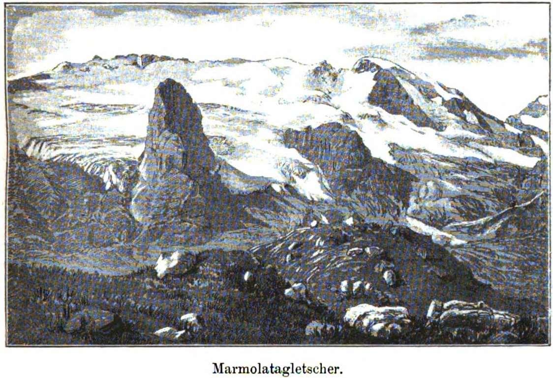
GlaciersoftheDolomites
Text by Prof. Alberto Carton, geomorphologist at the UniversityofPaduaandmemberoftheGeologicalHeritage NetworkoftheUNESCODolomitesFoundation,writtenonthe occasionofthefirstWorldDayforGlaciers(21March2025).
AbriefhistoryofglaciationintheDolomites
In order to consider the relationship between the landscapes of the Dolomitesandglaciation,wemustfirsttakealeapbackintimebyaround 20,000 years to when the glaciers occupied all of the Alpine valleys, includingthoseoftheDolomites,withthicknessesgreaterthan1,500m(up to2,000mintheBolzanoarea).Chronologically,weareintheso-calledLast Glacial Maximum, the period characterised by maximum expansion of glaciers. In this period, only the highest peaks emerged from this “sea” of ice,intheformofisolatedpeaks(nunataks).Theglaciersoriginatingfrom thelargeDolomitegroupsjoinedtogethertocreateanetworkofbranches that intersected between one valley and the next. Some slid over the currentDolomitepasses,whichatthetimeservedaspointsoftransfluence.
The particular diversity and distribution ofrocks in theDolomites hasalso enabledidentificationofthedirectionofmovementofglaciers,performing specific analyses not only on morphology, but also looking at the distributionofdebristransportedalongthevalleysandfromonevalleyto another.Thishasenabledtheidentificationofexamplesoftransfluence,for example,fromtheAdigebasintothePiavebasinthroughtheGardenaand SanPellegrinopasses.
The traces that remain most evident to this day in terms of glacial morphogenesis are those attributed to successive phases of retreat (melting) and advance of the glaciers. These occurred with intermittent and irregular periods during the late glacial period, which began around 17,000 years ago. The most frequently encountered forms that document thepresenceofglacialtonguesgraduallyretreatingwithinthetopography oftheDolomitesareglacialmoraines,steps,glacialvalleys,hangingvalleys, roches moutonnées, arêtes and glacial cirques. The latter are very common near the heads of valleys in eight of the nine Dolomite Systems making up the World Heritage Site, and it is there that the majority of the small remaining glaciers in the Dolomitesare found; the last remnants of
that great sea of ice that concealed the impressive forms of the “Pale Mountains”around20,000yearsago.ThesmallSystem8-Bletterbach,with its deep-cut valley that fed into the Adige valley features no traces or evidence of glacial processes due to its origin and altimetric characteristics.Oftheothereightsystems,onlySystem1-MontePelmo–CrodadaLago,system2-Marmolada,System3-PalediSanMartino,San Lucano, Belluno Dolomites and Vette Feltrine, System 5 - Northern Dolomites, and System 9 - Brenta Dolomites, are still home to glaciers or glacierets.
It is worth revisiting thewords written exactly one century ago by a great researcher of the Dolomites, Bruno Castiglioni, in one of his fine scientific works looking at several glaciers in the Dolomites (Castiglioni, 1925): “The Dolomitesarerecognisedfortheirforms,structuresandcolours,featuring carbonate and limestone rocks, [...] those seeking the allure of white expanses of snow, and the beauty of the glaciers that give life to the mountain environment, look elsewhere, in the main Alpine groups [...] However,itiswellknownthattheDolomitestooarejewelledwithpatches of pure snow, and also feature relatively notable numbers of glaciers. However, these have often retreated to the most remote valleys, and therefore have a limited importance in terms of the landscape, with Marmolada the sole exception. They are generally small, yet nevertheless of significant scientific interest, as demonstrated by studies already conductedonthem.”
StudyingtheglaciersoftheDolomites
The glaciers of the Dolomites have often remained at the fringes of scientificexplorationbecauseoftheirlimiteddimensionsandbecausethey donotcharacterisethemountainsasinotherareasoftheAlps.Theirrather smallsurfaceareaisduetothedecreaseinaveragealtitudeaswetravel eastwardsacrosstheAlps.Thisleadstoaconsequentreductioninsurfaces falling within the attitude bands that are climatically favourable for the formationandmaintenanceofglaciers.Furthermore,despitethepresence ofpeaksover3,000metres,thesteepnatureofDolomitetopographyworks againstglaciation.Theverticalornear-verticalnatureofmanyrockfaces minimises the extent of surfaces within altitude bands where snow accumulates, and which could host glaciers. Nevertheless, existing scientificresearch,particularlyhistorical,isextremelyinterestingbecause, whilstnotcontinuousovertime,itprovidesareasonablepictureofglacial evolutionintheDolomitessincethestartofthe19thcentury.Oneofthefirst
studies to mention the glaciers of the Dolomites dates back to 1888 and wasconductedbyRichter,alecturerattheUniversityofGraz,andpresident of the Deutscher und Österreichischer Alpenverein organisation and the International Glacier Commission. From this work (Richter, 1888) we can conclude that already at that time, in the Dolomites, the Brenta group (System9)featuredthegreatestamountofglaciation,with12glaciersand fourglacieretsforatotalsurfaceareaof464hectares.Thisexceedsthatof glaciers in the Pale di S. Martino group (System 3), estimated at 351 hectares,andisslightlylessthanthatintheMarmoladagroup(System2) at526hectares.

The glaciers around Cima Tosa in the Brenta group (System 9), from an 1888 drawing by EduardRichter(fromCartonA.,MartinS.,MasèV.PatuzziL.,StucchiM.,TomasoniR.,ViganòA., VisintainerM.,ZambottoM.(2021)-DolomitesWorldHeritageGeotrailI-FromGiudicarietothe NonValley(Trentino)AtrektoexploretheWorldHeritageFossilArchipelago.pp.144.
Richter’s work was followed, at the end of the 19th century, by a series of works of physical geography by Italian authors, accompanied by topographical studies and quantitative data on glaciers. The first glaciological considerations arose and the first markers were placed to measurevariationsintheirboundaries.TheworkofMarinelli(1910)andhis colleaguesFeruglioandToniolo,intheperiod1894–1910,compiledaccurate descriptions, photographs and survey points, which served as points to start or continue glaciological surveys. 39 glaciers, many of which
previously undocumented, were meticulously analysed. This made it possibletotraceaninitialpictureofglaciationintheDolomitesatthestart of the 20th century. However, these observations largely regarded the easternDolomites,leavingalack of data on the westernarea,which was coveredinmoredetailin1925byBrunoCastiglioni.
Itwashewho,inthesecondhalfofthetwenties,counteredthisabsenceof datafollowingthelastworkof1910byMarinelli,withseveralstudiesonthe conditions of a vast number of glaciers in both the eastern (Castiglioni 1930) and western (Castiglioni 1925) Dolomites. Subsequent works were largelyfocusedonindividualglaciers(Nangeroni,1938;DelLongoetal.,2001; Cibienetal.,2007).AcompletepictureofallglaciersintheSystemsofthe Dolomites World Heritage Site can also be drawn from consultation of glacial inventories, which compile data from surveys of glacial bodies. Comparingdatafromthe1950sandthestartofthe1960s(CGI-CNR,1962) andthoseofthemostrecentinventory(Smiragliaetalii,2015)givesusan overview of their evolution: reduction in surface area, fragmentation and extinction.
AnoverviewofglacialstudiesintheDolomitesdoesnotendhere:wemust also note very recent work performed with the most advanced surveying technologies, which provides valuable quantitative data on surface area, thickness,volumeandlossofmass(Crepazetalii,2013;Santinetalii,2019; Bondesan et alii, 2023; Securo et alii, 2024a; 2024b). Some parameters of these small glaciers can be remotely detected, enabling us to monitor, where their dimensions are compatible with the spatial resolution of satellites, glaciers located in areas that are difficult to access and to performhigh-frequencymonitoring.
ItisequallyinterestingtotracktheevolutionofglaciationintheDolomites with the help of cartography. Many different topographical maps have been created over the years documenting this area, progressively more preciseandaccurate,dependingofthemeasurementtoolsavailable.The nameofaglacierorasymbolindicatingitspresenceonahistoricalmap is of little use for glaciological research because there is often a lack of objective points of reference to use for subsequent comparison, but neverthelesstheyindicateitspresence.Oneexampleofthistypeisthefirst representationoftheMarmoladaglacier(MarmolataVedretta)intheAtlas Tyrolensis(Anich,Hueber,1775).

Representation(dottedarea)of the Marmoladaglacier(System 2)inthe AtlasTyrolensisof 1774.TheglacierappearstobedrawnattachedtothesmallerVernaleglacierbyastripofice occupying the entire head of the Contrin valley, passing through the Ombretta pass. This connectionisextremelyimprobableduetothespecificorographyhere.Inthesameimage, SassodelleUndici,oneofthetworockhumps,extremelyusefulasareferencepointtomonitor the position of the front of the glacier, is not accurately represented (da Anich P., HueberB., 1774–AtlasTyrolensis.Tyrolia-Verlag,Innsbruck–Wien).
Topographical maps with contour lines and spot heights are decidedly more useful for glaciological purposes, such as those produced by the Italian Military Geographical Institute (IGM 1:25,000 maps) or regional and provincial technical maps (CTR-CTP). Here we must mention a series of mapsofthecentral-eastern Alps,at1:50,000and1:25,000scaleproduced between 1898 and 1931 by Deutschen und Österreichischen Alpen Verein, whomappedthestateofglaciersmoreorlessacenturyago. Fiveofthese regard groups in the Dolomites World Heritage Site. These remain unsurpassedworksofprecision,bothintermsof altimetricrepresentation and the legibility of graphics and colours used. From a glaciological
perspective,theyareaninexhaustiblesourceofinformation,duetothefact that the topography is drawn with the curiosity of an alpinist and the competenceofanaturalist.

Excerptofthe1:25,000mapproducedin1931byDeutschenundÖsterreichischenAlpenVerein with indication of several of the glaciers of Pale di San Martino as they were 100 years ago. Some of these are now extinct, whilst others have shrunk immensely. These maps shine for theirextremeprecisioninaltimetricdetailacrossallglaciers(bluecontourlines),evenwhere theiceiscoveredbydebris(fromDeutschenundÖsterreichischenAlpenVerein,1931-Karte derPalagruppe.Scale:1:25,000).
The allure and notoriety of the Dolomites drew illustrious and illuminated individuals to the area as early as the 19th century, many of whom publishedaccuratedescriptionsoftheirtravels,accompaniedbydetailed records,fieldsurveys,drawingsandpaintings,oftenfeaturinghigh-altitude landscapes with glaciers. We cannot list them all here, but notable examples include the watercolours and drawings of Edward Theodore Compton, a German alpinist, painter and artist (of English origins) well knownforhisalpinelandscapes.

ThesnowypeakofCimaTosaandCrozzondiBrenta,thenmarkedasCastellodiBrenta,inthe Brentagroup(System9),froman1883drawingbyEdwardTheodoreCompton(fromCarton A., Martin S., Masè V. Patuzzi L., Stucchi M., Tomasoni R., Viganò A., Visintainer M., Zambotto M. (2021) - DolomitesWorld Heritage Geotrail I - From Giudicarie to the Non Valley (Trentino) A trektoexploretheWorldHeritageFossilArchipelago.pp.144.
FeaturesoftheglaciersintheDolomites
Despite having a very limited extent the glaciers in the Dolomites World Heritage Site, represent a distinctive characteristic of these mountain groups,jealouslyguardedinthecreasesofthetopography,asthoughthe mountains are trying to conceal and preserve them. Soon, the Dolomites WorldHeritageSitewillnolongerbeabletocelebratetheirpresence.These smallglaciersaretheremainsofthosegreatseasoficethatenvelopedall eight systems between 15,000 and 20,000 years ago. Until just a few decades ago, there were numerous glaciers in the Dolomites (CGI-CNR, 1962), but in recent times they have all shrunk notably, in terms of their surface area and volume. Only those at high altitudes have partially survived,exposedtothenorthorwestandprotectedbythehighestpeaks, fed not only by snowfall but also by avalanches. These factors have enabled their persistence, despite the fact that the respective accumulation basins were (and sometimes still are) located below the snowlinethatnormallymarkstheboundaryfortheirsurvival.Onlythetwo largestglaciersoftheDolomites,MarmoladaandtheFradustaglacierhad the benefit of accumulation basins above the snow line, and being fed
exclusivelybysnowandnotavalanches,indicatedtheactualclimaticsnow line, rather than the orographic one. The small glaciers of the Dolomites, duetotheirlimiteddimensions,respondveryquicklytochangesinclimate, even of a short duration, with consequent changes in their form and size even in the wake of passing environmental changes, such winters with particularlyhigh snowfall orverywarm summers. Recently,identifying the marginsorfrontoftheglaciershasbecomeverychallenging,becausethey are often masked by large amounts of debris, which in some cases completely covers the glacier, transforming it into a “debris-covered glacier” (Seppi et alii, 2015). This covering of debris hides the body of ice, removing a unique and important element of the landscape of the Dolomites,butactually protectsthe ice,slowing downitsmelting.In other places,furtherreductioninthethicknessofalready“thin”glaciersleadsto the emergence of jagged rocks, irradiating heat, accelerating melting or leadingtofragmentationintosmallerglacialbodies.
TherearenocomprehensivestudiescoveringallglaciersintheDolomites World Heritage Site because the orographic concept of the “Dolomites”, both in the traditional segmentation of the Alps of 1926 (Bertoglio et alii, 1979) and the more recent SOIUSA International Standardized Mountain Subdivision of the Alps (Marazzi. 2005) the Brenta group was never considered.Ageneraloverviewoftheirevolution,althoughnotupdatedin recent years, can be drawn by comparing data provided by two glaciologicalinventories(CGI-CNR,1962;Smiragliaetal.,2015)thatcovera periodofmoreorless50years.Attheendofthe1950s,theDolomitesWorld Heritage Site contained 40 glaciers, with a total surface area of 10.6 Km2, whilst according to the most recent survey, there are 71 glaciers and glacierets,withasurfaceareaof5.92Km2(a56%reduction).Wearestruck by the increased number of glaciers in a period of full-scale melting, but we must rememberthat this apparent increase actuallyderives from the breaking up of many glacial bodies. Of these, 23 are considered alpine glaciers1,whilsttheremaining48arecategorisedasglacierets2;83%ofthe totalhaveanorthernaspect(N,NE,NW).
Again,accordingtothemostrecentinventory(2009–2011)theglaciersare distributedasfollows:
1 Glacier, potentially large, without a tongue down the valley, and located on mountain slopes. Its shape and evolution are dictated by the morphological characteristics of the site where it is located. (Smiragliaetal.,2015).
2 Abodyoficewithanundefinedshapeandlimitedsize,locatedinamountainbowl,ofteninpre-existing glacialcirques,andcharacterisedbyaveryslowflowornoflowatall.Itmustbeobservableforatleast twoconsecutiveyears(Smiragliaetal.,2015).
3 PalediSanMartino,San Lucano,Dolomiti Bellunesi,VetteFeltrine
Recent studies, despite not taking into consideration all glaciers of the Dolomites World Heritage Site, have traced the glacial evolution of the Dolomites over longer arcs of time. The Veneto Regional Environmental Protection Agency (ARPAV), for example, has analysed changes in the surfaceofseveralglaciersoftheDolomites(Crepazetal.,2013)overthelast 100 years, considering just 27 of the approximately 70 glacial bodies present.Thedecisiontousesuchanarrowsamplewasdictatedbythefact that surface-area data running from 1888 to 2009 was only available for the glaciers selected. The study found that the total surface area had decreasedfrom9.1km2in1910to4.7km2in2009(-4.48km2,corresponding to49%in100years).From1910to1982,therewasadecreaseof2.46km2(28.6%),whilstinthelast30years,theglacialareashrankby2.02km2(-30%).
Analysisofindividualglaciersalsoidentifiedworryingreductionsinsurface area:theFradustaglacier,inSystem3(PalediS.Martino)shrankfrom1.07 km2in1910to0.11km2,correspondingtoareductionof89%(approx.73%in thelast30years).TheMarmoladaglacier(System2)shrankfrom3.35km2 to 1.60 km2 (-52%). Finally, the Antelao Superiore glacier in System 5 (Northern Dolomites) lost shrank by 0.185 km2 (-41.05%), with a notable accelerationinthelast30years.Ofthe27glaciersanalysed,onlythreesaw shrinkageoflessthan20%overthelastcentury(Crepazetalii,2013).

UpperAntelaoGlacierin2007(Courtesy ofAgencyforEnvironmentalPrevention andProtectionoftheVenetoRegion).
Using sophisticated new technology for remote monitoring of changes in the mass of glaciers, combined with structure-from-motion3 (SfM) technique applied to aerial and land-based photography from various positions,includinghistoricalimages,it ispossibletomapchangesin the mass of past glaciers. One recent study (Securo et alii 2024b) performed with these tools, changes in surface area and mass report4 have been calculatedfornineglaciersoftheDolomites,from1980sto2023,obtaining a quantitative overview of the current state of the glaciers of Marmolada (System2),FradustaandTravignolo(System3),PoperaAlto,PoperaPensile, Cristallo,SorapissOccidentaleandAntelaoSuperiore(System5).Thenine glaciersobservedhavelost56%oftheirsurfaceareaand0.64±0.05mw.e.
5 /year-1fromthestartofthe1980sto2023.Thetotalvolumelossis0.105Gt, ofwhich0.022Gtinthelast13years,between2010and2023(Securoetalii,
3 Structure from motion is a calculation technique that enables reconstruction of the form of objects by automaticmaskingofpointsfromabodyofphotographs.
4 Massreport:annualanalysisofgainsandlossesinmass,iceandsnowoccurringonaglacier.Thefindings ofthereportmaybepositive(theglacierhasincreaseditsmassandadvanced),negative(theglacier hasreducedinmassandretreated)ortheremaybenochange(stationaryglacier).Thefindingsofthe report are expressed in water equivalent, taking into account that ice has an average density of 0.91 g/cm3(Glossary-LombardGlaciologicalService).
5 W.e.= waterequivalent,unitof measurementusedto expressthelossinvolumeofaglacierconverting the change in surface level of the glacier into water equivalent using the density of the material in question(snow,iceorfirn).
2024b). From the study, it also emerges that currently their accumulation areasarebelowthesnowlineandthatreductionsinareaarenotuniform acrossallglaciers.Wheredebriscoverageisabundant,suchastheglaciers of Popera Alto, Travignolo and Sorapiss, there is limited shrinkage, particularlyoverthelastdecade.Glacierswithlessprotection,ontheother hand,suchasFradustaandMarmolada,havebeenthosewiththegreatest lossesinsurfaceareasincethe1980s:-89%and-60%,respectively.Itisalso confirmed that the apparent resistance of glaciers in the Dolomites to climate change is due to their orographic protection, provided by the jointedmorphologyoftheDolomitesandtheimportanceofavalanchesas a source of accumulation (Securo et alii, 2024b). The Marmolada glacier remainsthelargestoftheDolomites.Itsretreatcontributesto66%oftotal lossofareasincethe1980sanditcurrentlyrepresents55%oftotalglacier areaintheDolomites.

Marmoladaglacier
Fradusta Glacier in 2007 (Courtesy of Agency for Environmental Prevention andProtectionoftheVenetoRegion).
TheMarmoladaglacier,nowdividedintomultipleparts(MainMarmolada, Central Marmolada, Punta Penia, and West Marmolada), in addition to
alwayshavebeenthelargestglacierintheDolomites,iswithoutdoubtthe most widely studied, partly due to its accessibility and the possibility of viewingitsentiretyfrommultiplevantagepoints.Ithasbeenthesubjectof many drawings, paintings, images, photographs and surveys over the years, and there is thus a significant amount of data available that has enabledmappingofchangesintheareaoftheglaciersincetheendofthe nineteenthcentury(Carton,2017).
In1888,theglaciercoveredanareaof4.28km2.SincetheendoftheLittle IceAge(around1860)theglaciershrankatarelativelyconstantrate;inthe lastcentury,itadvancedonlyduringtwobriefperiods(1910–1920and1970–1980).In2015,theMarmoladaglaciercovered1.48km2(Cartonetalii,2017) forareductioninitsareaof66%comparedtoinitialobservationsrecorded in1888.Themostrecentobservations,in2021(Bondesanetalii,2023),show a 72% reduction in surface area covered by ice over 116 years and a reductioninvolumeof89%(from181Mm3to19Mm3).From1971to2015,the front edges of glaciers have retreated by several hundreds of metres, retreatingupto650minthecentralportion.Sincethe2000s,theaverage rateofretreathasincreased,from3.94m/yearbetween1880and2000to 31.95m/yearfrom2001to2021(Bondesanetalii,2023).
AdrawingofMarmoladaanditsglacier,withdimensionsverydifferentfromthoseseentoday, byRichterandpublishedinhis1888work(fromRichterE.(1888)-DieGletscherderOstalpen, HandbücherzurDeutscherLandesundVolkskunde).

Representation of glacial areas in 1888 (black), 1905 (purple), 1954 (dark green), 1982 (light green), 2000 (blue) and 2015 (red) from GIS processing of historical cartographic data. The reduction in area from 1888 to 2015 is around 70% (from Benetton S. – 2015-2016, il ritiro del ghiacciaiodellaMarmolada:l’evoluzionedellafrontedopolaPiccolaEtàGlaciale[Retreatof the Marmolada Glacier: movement of the front boundary since the Little Ice Age]. Master’s Dissertation-GeologyandTechnicalGeologySupervisor:Prof.A.Bondesan).
The 1962 inventory (CGI, 1962) recorded eight glaciers in the entire group. Since then, some of these have disappeared, whilst others have fragmented.Themostrecentinventory(Smiragliaetalii,2015)reducedthe numberofglacierstosevenandfurtheramendedtheirboundaries.During its considerable retreat over the last century, the front of the glacier has thinnedgreatly.Considerthat,duringtheFirstWorldWar,theglacierhada sufficientdepthtohosttunnelsandundergrounddefencesdugcutintothe ice and housed 300 Austro-Hungarian soldiers in the renowned “Ice City” (Bondesanetal.,2015).
Investigationsusingland-basedgeoradar6 in2004andsubsequentlyfrom ahelicopterin2015(Santinetalii,2019)enabledestimationofanaverage icethicknessin2004of18.0m,withamaximumofcloseto50m.In2014,the averageicethicknesshadfallento12.9m,andthemaximumthicknessto around 40 m. Comparing the two data sets, we see a 30% reduction in volume,whiletheareacoveredbytheglacierdecreasedby22%,withnew areas free from ice. The authors of the study estimated that if the
6Georadar,orground-penetratingradar,isanon-invasivetechniqueusedingeophysicstostudythe initiallayerofsubsoil.Itworksbyanalysingthereflectionsofelectromagneticwavesemittedintothe ground.
Marmoladaglaciercontinuestoreduceinvolumeatthesamerateasthe intenyearsconsidered(2004–2014),itwillprobablydisappearby2050.
Unfortunately,inJuly2022,theMarmoladaglacierwasinthenews,notfor scientific reasons, but because of the collapse of a portion of ice, generatinganavalancheofwater,iceanddebris.
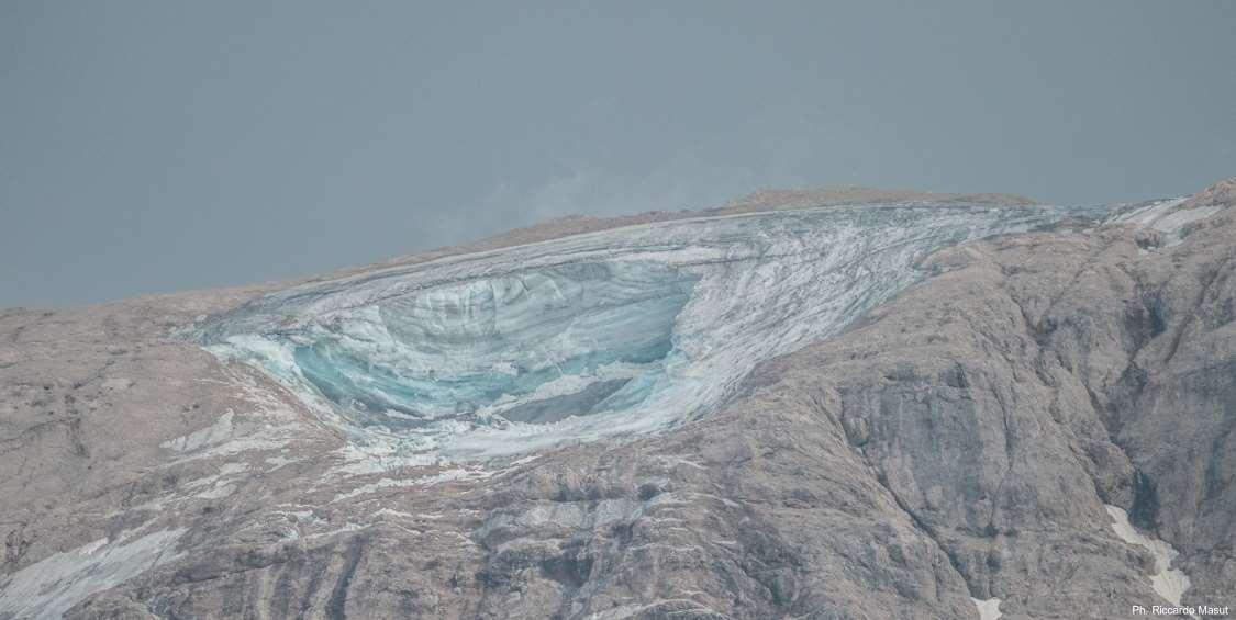
MarmoladaGlacier.Thescarleftafterdetachmentofthefrontportionhasarectangularform, measuring 65–70 m (east to west) by 85–90 m (north to south), corresponding to a total volumeofapprox.70,400m3.Ph.RiccardoMasut|ArchivioFondazioneDolomitiUNESCO.
The collapse affected a small isolated glacier, located with a shallow cirque,closetotheridgeapproximately600mwestofthePeniapeak(3,343 m).Theaffectedglacierwasconnectedtotheglacialfrontuntil2006,but separatedfromitin2012.Thecollapse,whichinvolvedanestimatedvolume of70,400m3ofmaterial,leftascarintheglacier,comparabletoawallof iceupto23mhigh.Thecollapsedicemasssliddownthenorthfacefor2.3 km,leavingbehindlargeblocksofglacialdebrismixedwithiceontheless steepsections.Theflowthencrossedthenormalroutetothepeak,striking variousalpinists,killing11peopleandleaving7injured.Thezonewherethe material detached from was immediately placed under monitoring, to ensuretherewasnorepeatofsuchanevent,usinganautomatedsystem atthefootoftheslope.ThisusedaDopplerradarandtwodifferentradar inferometerscapableofdetectinganymovements.Nomovementsinthe landscape were observed for the rest of the summer (Bondesan et alii, 2023).
Various investigations were launched in the wake of this disaster, in an attempt to understand the dynamics of the event and whether it was possible to identify any prior indicators. The Court of Trento opened an preliminary investigation exploring possible negligence, but the findings statedthat“onthebasisofavailableknowledge,theevencouldnothave beenpredicted”and“itwasnotpossibletoidentifyelementsthatcould,if observedinthedaysprior,suggestahighriskofimminentcollapse”.Onthe basis of these findings, the Trento Court announced the closure of the investigationintothedisaster.
IntheDolomites,notonlyMarmoladahasledustoreflectonthepotential dangersassociatedwith thepresenceofice.Theseissuesgenerallyarise in thepresenceofglaciersof significantdimensions, suchasthose in the westernandcentralAlps(Mortaraetalii,GAPHAZ,2017).In1994,thealmost extinct glacier of Val d’Arcia (Pelmo, System 1), completely covered by debris, made headlines: after a short but intense storm, a debris flow detached from material covering an area of glacial ice on the northern slope of Mount Pelmo. Approximately 200,000 m3 of material travelled down the valley,meeting the Strada Nazionale 251 road(Del Longoet alii, 2001;Chiarleetalii,2007).
ExploringtheglaciersoftheDolomites
OneofthebestwaystoexploretheglaciersoftheDolomitesistovisitthem in person with an expert who can tell you their story and point out the landformsassociatedwiththeirevolution.ForglaciersintheDolomites,like othersintheAlps,easy“glaciologicaltrails”havealsobeencreated.These introduce visitorsto the various landformsbuilt or shaped bythe glaciers and the points glacial tongues are documented to have reached in the various historical phases. These trails engage and educate. Three glaciologicaltrailshavebeencreatedintheDolomitesWorldHeritageSite: intheMarmolada,PalediS.Martino(Fradustaglacier)andAntelaoareas.
Marmolada: two trails are described in volume 3 of “Itinerari glaciologici sullemontagneitaliane”[GlaciologicalitinerariesintheItalianmountains], compiled bythe ItalianGlaciological Committee in collaboration with the Italian Geological Society (Trails 19 and 19b - Italian Glaciological Committee, Italian Geological Society, 2017). The first leads us to a panoramic viewpoint, along route SAT 601 (Tridentine Mountaineering Society-VieldelPanroute),fromwherewecanobservetheentireglacier and,withthehelpofcartographicandiconographicdocuments,tracethe different stages in its considerable retreat. The second trail features two stopslocatedneartoCapannaalGhiacciaiomountainhutandalongside
thecentreofthefrontedgeoftheglacier.SettingofffromPiandeiFiacconi, wecanobservevariousevidenceofglacialmargins.Unfortunately,Piandei Fiacconi is no longer easily accessible, as it was when the guide was published, due to an avalanche in December 2020 that destroyed the mountainhutofthesamenameandthearrivalpointoftheFedaiacable lift.
PalediSanMartino:theglaciologicaltrailwascreatedbytheGlaciological Committee Società of the SAT (Tridentine Mountaineering Society) in collaborationwiththePaneveggioPalediSanMartinoNaturalPark,withthe aim of introducing visitors to the Fradusta glacier. The trail begins at the PedrottiallaRosettamountainhutandleadstothenorthernsummitofthe Fradustapeak,whereitisnowpossibletoviewthelastupperstretchofthe glacier.Alongtheway,wecanviewtracesofmorainesleftbytheglacier, rochesmoutonnéesandsurveyandphotographystations,someuseduntil the beginning of the 20th century. The trail also enables us to observe tracesofalakethatoccupied23,500m2withadepthof11metresin1994, disappearing suddenly between the end of August and the start of Septemberofthesameyear.
High in Val Venegia, near to the Baita Segantini mountain hut, an observation point has been created with an informational board on the Travignolo glacier which, in the shadow of Cimon della Pala, is retreating more slowly than the Fradusta glacier, being fed by avalanches and partiallyprotectedfromthesun.
Antelao:Theglaciologicalnaturetrail(Scortegagna,2001)largelyexplores the areas in which the lower or western glacier and the upper or eastern glacier of Antelao extended. The guide booklet for the trail provides a comprehensive overview of the Antelao massif, focusing primarily on the stateofremainingglaciersandtheirevolution.Inadditiontoadescription oftherouteandenvironmentalemergenciesinthearea,thereisillustration of its geographical and geomorphological, hydrographic, botanical, faunisticandanthropiccharacteristics.
For an “iconographic” journey through hundreds of photographs of the glaciers of the Dolomites, it is recommended to browse the volumes of Zanon(1990),Secchieri(2004,2012),Cartonetalii(2011)andDeBattagliaet alii,(2013).Finally,theglaciersofPalediSanMartinoarepreciselydescribed and analysed comparing current photographs with those from the historicalarchivesoftheCastiglionifamilyinthevolumebyBaccolo(2020).
CAPTIONS
AnichP.,HueberB.,1774–AtlasTyrolensis.Tyrolia-Verlag,Innsbruck–Wien. BaccoloG.(2020)-Piccolighiacciaialpini.Sulle traccediBrunoCastiglionitralePalediSan Martino.CollanadelMuseodiGeografia.UniversitàdiPadova.CIERREEd.113pp.
BenettonS.(2015-2016)IlritirodelghiacciaiodellaMarmolada:l’evoluzionedellafrontedopo laPiccolaEtàGlaciale.TesidiLaureamagistraleinGeologiaeGeologiaTecnica.Relatore:Prof. A.Bondesan).
BertoglioG.,DeSimoniG.(1979)-PartizionedelleAlpiin220Gruppi. Boll.Ass.It.Cart.,46,7-17.
Bondesan A., Francese R. G. (2023) - The climate-driven disaster of the Marmolada Glacier (Italy).Geomorphology,431,108687.sciencedirect.com
Bondesan, A., Carton, A., Laterza, V., (2015) - Leo Handl and the ice city (Marmolada Glacier, Italy).Rend.On.Soc.Geol.It.36,31–34.researchgate.net
Carton A., Bondesan A., Benetton S., (2017) - Marmolada, la regina della Dolomiti, Itinerari GlaciologicisulleMontagneItaliane3.Itinerari19Ae19B,pp.189–212.
CartonA.,MartinS.,MasèV.,PatuzziL.,StucchiM.,TomasoniR.,ViganòA.,VisintainerM.,Zambotto M.(2021)-DolomitesWorldHeritageGeotrailI-Giudicarie–VallediNon(Trentino)Untrekking allascopertadell'arcipelagofossiledelPatrimonioMondiale.144pp.
CartonA.,VarottoM,(acuradi)(2011)-Marmolada,CIERREed.,DipartimentodiGeografia“G. Morandini”,UniversitàdiPadova.420pp.
CastiglioniB.(1925)–AlcunighiacciaidelleDolomitiedilloroambienteorograficoeclimatico BollettinodelClubAlpinoItaliano,XLII,75,pp.323-380.
CastiglioniB.(1930)-RisultatidiunarecentevisitaaighiacciaiCadorini.Mem.Geol.eGeogr. diG.Dainelli,1,pp.291–317.
CGI-CNR,(1962)CatastodeiGhiacciaiItaliani,GhiacciaidelleTreVenezieedell’Appennino
Chiarle,M.,Iannotti,S.,Mortara,G.,Deline,P.(2007)-Recentdebrisflowoccurrencesassociated withglaciersintheAlps.GlobalandPlanetaryChange,56,pp.123–136.sciencedirect.com
CibienM., FerrareseF., MeneghelM.(2007)-The Glaciers of Mount Antelao (Dolomites, Italy) sincetheLittleIceAge.GeografiaFisicaDinamicaQuaternaria,30,pp.131-139.
Comitato Glaciologico Italiano, Società Geologica Italiana, 2017 – Itinerari: 13. I ghiacciai dell’Adamello e 19. Marmolada, la Regina delle Dolomiti.Itinerariglaciologicisullemontagne italiane,vol3.GuideGeologicheRegionali,pp.43-86epp.189-212.
Crepaz A., Cagnati A., Luca G. D. (2013) - Evoluzione dei ghiacciai delle Dolomiti negli ultimi centoanni.NeveeValanghe80,pp.20–25.
DeBattagliaF.,CartonA.,PistoiaU.,(2013)–DolomitidiBrenta.CIERREEd. 400pp.
Del Longo M., Finzi E., Galgaro A., Godio A., Luchetta A., Pellegrini G. B., Zambrano R. (2001)Responses of the Val D’ Arcia small dolomitic glacier (Mount Pelmo, Eastern Alps) to recent climaticchanges.GeografiaFisicaeDinamicaQuaternaria,24,pp43–55.
DeutschenundÖsterreichischenAlpenVerein,1931-KartederPalagruppe.Scala1:25.000.
GAPHAZ 2017: Valutazione della pericolosità associata a ghiacciai e permafrost in aree montane – Documento di orientamento tecnico. A cura di Allen, S., Frey, H., Huggel, C. et al.
StandingGrouponGlacierandPermafrostHazardsinMountains(GAPHAZ)dellaInternational AssociationofCryosphericSciences(IACS)edellaInternationalPermafrostAssociation(IPA). Zurigo,Svizzera/Lima,Peru,72pp.gaphaz.org
Heim(1885)-HandbuchderGletscherkunde. Stuttgart.
MarazziS.(2005)-AtlanteorograficodelleAlpi.SOIUSA(Suddivisioneorograficaunificatadel SistemaAlpino).Priuli&VerluccaEditori,Ivrea,416pp.
MarinelliO.(1910)-IGhiacciaidelleAlpiVenete.Mem.Geografiche.Suppl.Riv.Geogr.It.,4,pp. 3–289.
MattanaU.,VarottoM.,(2010)-Il ritiro del Ghiacciaio della Marmolada nell’ultimotrentennio LeAlpiVenete,64(1),pp.68-75.
NangeroniG.,(1938)FenomeniglacialinelGruppodiSella(Dolomiti).Boll.Com.Glac.It.Prima serie,18,Torino,pp.105-119.
Pasta, M., Pavan, M., Sonda, D., Carollo, F., Cagnati, A., 2005. Prospezione di alcuni ghiacciai dolomiticitramitetecnicheGPReGPS.NeveValanghe,56,pp.50–59.
PorroC.ELabusP.,(1927)–AtlantedeiGhiacciaiItaliani.Firenze,IstitutoGeograficoMilitare.
PorroC.,1925–ElencodeiGhiacciaiItaliani.Parma,UfficioIdrograficodelPo,61p.
Richter E. (1888) - Die Gletscher der Ostalpen, Handbücher zur Deutscher Landes und Volkskunde
RuthnerVonA.(1857)-UeberdieVerbreitungvonGletschernindenoesterreichischenAlpen MitteillungenderGeogr.Gesellsch.,I,Wien.
Santin I., Colucci R. R., Žebre M., Pavan M., Cagnati A., Forte E. (2019) - Recent evolution of Marmoladaglacier(Dolomites,Italy)bymeansofgroundandairborneGPRsurveys.Remote SensingofEnvironment,235,111442.sciencedirect.com
SecchieriF.(2024)-Climaeghiacciai.IlcasoDolomiti.CIERREEd.256pp.
SecchieriF.(2012)–IghiacciaidelleDolomiti–RegioneVeneto.GalivernaEd.220pp.
ScortegagnaU.(2001)-Ilsentieronaturalistico–glaciologicodell’Antelao.ClubAlpinoItaliano –ComitatoScientificoVeneto–Friulano–Giuliano.CIERREEd.104pp.
SecuroA.,DelGobboC.,RettigL.,PillonS.,LucaA.D.,FontanaD.,FasilE.B.,Colucci,R.R.(2024a) - A glacier in transition: Surface elevation change, ELA and geomorphic evolution of a very smallglacierintheDolomites(S-EAlps),Geomorphology,444.sciencedirect.com
SecuroA.,GobboC.D.,BaccoloG.,BarbanteC.,CitterioM.,BlasiF.D.,MarcerM.,ValtM.,Colucci, R. R. (2024b) - The Glaciers of the Dolomites: last 40 years of melting. EGUSphere preprint repository.egusphere.copernicus.org
SeppiR.,ZanonerT.,CartonA.,BondesanA.,FranceseR.,CarturanL.,ZumianiM.,GiorgiM.,Ninfo A. (2015) - Current transition from glacial to periglacial processes in the Dolomites (SouthEasternAlps).Geomorphology,228,pp.71–86.sciencedirect.com
Smiraglia C. & Diolaiuti G. (Editors), 2015 - The New Italian Glacier Inventory. Ev-K2-CNR, BergamoPubl.,400pp.
TauferG.,GilliE.,2009–Fradusta,ghiacciaiochevascomparendo.BollettinoSAT,LXXII,3,pp.712.
ZanonG.(1990)–IghiacciaidelVeneto.Ed.Canova,79pp.
ŽebreM.,ColucciR.R.,GiorgiF.,GlasserN.F.,RacoviteanuA.E.,GobboC.D(2021)-200yearsof equilibrium-line altitude variability across the European Alps (1901-2100). Climate Dynamics, 56,1183–1201.researchgate.net