Tips
Midwest NATIONAL PARKS OF THE
on
National Parks Prepare like a pro with insider advice A Prairie’s Subterranean Secret Explore the labyrinthine marvels of a complex cave Wolf Wonder in the Upper Midwest Isle Royale’s conservation efforts at work
Visiting
Rugged, isolated islands. Southern boreal and northern hardwood forests. Four glorious seasons, complete with vibrant fall foliage. Wilds where apex predators not only survive but thrive. From exposed rock ridges to wetlands, fascinating, moss-covered formations and urban climes, national parks in the Midwestern United States offer more than meets the eye.
Providing a surprising variety of environs — including open farmland, glaciated landscapes, mixed prairielands and clastic dikes in hues of tan, green and red — the Midwest is also home to lumbering buffalo, elusive grey wolves, bighorn sheep and bald eagles.
Whether you favor lakes, deep forests, fossils or something in between, so much of the Midwestern U.S. is just waiting to be explored. And if you’re fortunate enough to live in the region, America’s breathtaking backyards — National Park Service-managed lands — are a hop, skip and a jump from home. Considering a move to the Midwestern United States? Already settled in?
United Van Lines can not only get you there, but also help you settle in, get familiar with your new neighborhood, and embrace the beauty and natural resources that surround you.
2 UNITED VAN LINES NATIONAL PARKS GUIDE MIDWEST
MIDWEST UNITED VAN LINES NATIONAL PARKS GUIDE 1 04 INDIANA Indiana Dunes National Park 08 MICHIGAN Isle Royale National Park 14 MINNESOTA Voyageurs National Park 18 MISSOURI Gateway Arch National Park 22 NORTH DAKOTA Theodore Roosevelt National Park 26 OHIO Cuyahoga Valley National Park 30 SOUTH DAKOTA Badlands National Park 32 SOUTH DAKOTA Wind Cave National Park Contents Considering a move to the Midwestern United States? Already settled in? Wilderness, dunes and winding waterways are calling — and so much more.
GETTY
Written by Designed by Cover Art Jennifer Olvera Emily Rhodes Getty
Tips for Visiting National Parks
Get a Lay of the Land
Whether you prefer a quick weekend jaunt or a full-on vacation, it’s important to get the lay of the land before visiting the Midwest’s national parks, as these destinations are among the remotest areas on Earth. As such, you’ll lack access to certain necessities; cell service can be spotty; and weather and road conditions can change in the blink of an eye.
Check the Park Website
Check the parks’ official website for things like road and trail closures before you go — otherwise you could be met with a closed road, entrance or trail that can derail an otherwise well-planned adventure. This is the wilderness, after all, and you’re at the mercy of mother nature every single day.
Plan Your Routes and Pack a Map
It’s often an hours-long drive through challenging — not to mention exhilarating — driving conditions when traveling from one end of most national parks to the other. Plan
Adventure Awaits in Your Own Backyard
PREP EARLY
Get an annual national park pass
your routes and map out everything in advance. It’s also a good idea to purchase hard-copy maps, like National Geographic’s waterproof trail map series. They not only include topography, but also roads and routes not detailed on regular maps — or, frankly, the ones you receive at the gate.
Time it Right
Because the parks are so vast, timing is everything. Cuyahoga Valley, for example, spans 33,000 acres. Group viewpoints and hikes by regions within the park; note the distance and time between destinations; and know how far it is to your must-sees in advance. No one wants to end up mid-mountain and crunched for time. Account for the fact that these drives can take longer than expected — mountain, unpaved and meandering roads are that way. Consider, too, what time of year is right for your visit. In some parts of the country, the summer heat is oppressive, while winter brings seasonal road closures that render parks, or parts of parks, off-limits for months at a time. By contrast, offseason visits — spring and fall — prove more peaceful and less populated, while providing a beauty of their own. However, these can also be times when certain regions receive the most rain.
Buy a park passport — and stamp it at each visitor’s center
Book early — nearby accommodations fill up well in advance
TAKE SELF CARE
Bring proper gear — and prepare for weather changes
Dress in layers and bring a daypack
Drink water — and lots of it
Slather on sunscreen, regardless of the weather
Pack a picnic, as dining options are limited-to-non-existent
TIME TO GO!
Stop by the gift shop — they tend to be great
Gas up the night before — hours vary and options are few and far between
Combine camping with a stay in a historic lodge or Airbnb
Befriend park rangers for insider information
Download park, weather and GPS apps in advance
Check the park website for time entry requirements
Leave no trace
2 UNITED VAN LINES NATIONAL PARKS GUIDE MIDWEST

3 MADISON OREN
Indiana
Indiana Dunes National Park
NATIONAL PARKS OF
Indiana Dunes National Park
With more than 15,000 acres — including 15 miles of southern Lake Michigan shoreline — Indiana Dunes National Park features more than 50 miles of trails, which intersect rugged dunes, sundrenched prairies, bird-populated wetlands, snaking rivers and serene forests.

Brimming with four seasons of picturesque to-dos, each rewarding in its own way, visitors can not only hike, but also build sandcastles, camp, fish, birdwatch and go horseback riding amid spectacular foliage. And when the weather turns cold? There’s always snowshoeing, sledding and crosscountry skiing.
THE FLORA AND FAUNA
Situated within several ecological transition zones, “The Dunes” pack a punch, ranking fourth in biological diversity among the country’s national parks. Here, some species of which flourish on account of past climatic changes. All told, there are 46 species of mammals, 18 species of amphibians, 23 species of reptiles, 71 species of fish, 60 butterfly species (including the endangered Karner blue butterfly), 350 species of birds — many migratory — and 60 species of damselflies and dragonflies.
From coyotes to white-tail deer and a great blue heron rookery, opportunities for wildlife-spotting are at every turn.
Shaped by glacial effects and changing weather patterns, the park is a haven for 1,130 native vascular plants, too, among them the federally threatened Pitcher’s thistle. Home to 30% of Indiana’s listed rare, threatened, endangered and of-special-concern plant species, the dunes landscape contains flora common to eastern deciduous forests, remnants of boreal forests, wetlands, tallgrass prairies and species typically seen along the Atlantic coast.
THE WEATHER
With weather that’s significantly affected by Lake Michigan, the conditions at Indiana Dunes can quickly change. Typical, though, are
4 UNITED VAN LINES NATIONAL PARKS GUIDE MIDWEST
MADISON OREN
ADAM BOUSE
INDIANA
sunny, hot, humid summers that usually cap around the mid-80s F. Pleasant, dry weather arrives on account of fronts that descend from Canada.
On the other hand, winters tend to be cloudy and in the mid 30s F, dipping into the low 20s F — even below 0 F — an average of 15 days each year. During periods of extreme cold, skies tend to be clear.
Be sure to check the park’s website for weather and water conditions.
THE HIKES, DRIVES AND VIEWPOINTS
COWLES BOG TRAIL
Featuring a staggering array of plant diversity, the 4.3-mile, lollipop-shaped Cowles Bog Trail journeys along a moderately challenging route through wetlands, savanna and dunes, as well as along the shores of Lake Michigan. A chance to marvel at several distinct habitats — ponds, marshes, swamps,
black oak savannas and beaches — you can expect plenty of steep, sandy climbs.
WEST BEACH - DUNE SUCCESSIONAL TRAIL
Explore four stages of dune development on the 1.1-mile West Beach - Dune Succession Trail, starting at the beach and ending at the boardwalk, which takes you through a forest rising from the sand.
THE 3 DUNE CHALLENGE
Those seeking a more challenging hike head to nearby Indiana Dunes State Park, where the 3 Dune Challenge offers a 1.5-mile workout. Beginning at the nature center, it features 552 vertical feet to climb. The reward? Breathtaking views from the summit.

LITTLE CALUMET RIVER & MONKE PRAIRIE TRAIL
The 3.9-mile Little Calumet River and Monke Prairie Trail offers a lovely
introduction to the park’s biodiversity, traveling through many habitats and affording opportunities to relax at the beach. Connecting Bailly Homestead, Chellberg Farm and the Dunes Learning Center, it passes through the tranquil Mnoke Prairie, skirts the Little Calumet River valley, and follows a boardwalk through wet bottomlands before ascending into a hardwood forest and pine plantation.
MOUNT BALDY BEACH TRAIL
Short with a steep trip down the largest living dune in the national park, the somewhat strenuous, .9-mile Mount Baldy Beach Trail brings you to the shimmering waterfront.
EAST DUNES HIGHWAY/LAKE
MICHIGAN SHORELINE SCENIC DRIVE
Interchangeably called the East Dunes Highway and the Lake Michigan Shoreline Scenic Drive this journey takes you through picturesque landscapes, industrial areas and a breathtaking beach vista within the national park. From Gary traveling east, you’ll eventually reach Indiana Dunes National Park on a route that continues well beyond, as the entirety of U.S. Route 12 is 2,484 miles long.
ABOUT THE PARK
LOCATION
Northwest Indiana
ESTABLISHED
February 15, 2019
AREA
15,349 acres
MIDWEST UNITED VAN LINES NATIONAL PARKS GUIDE 5

GETTY

GETTY
Isle Royale National Park
Michigan NATIONAL PARKS OF
Isle Royale National Park

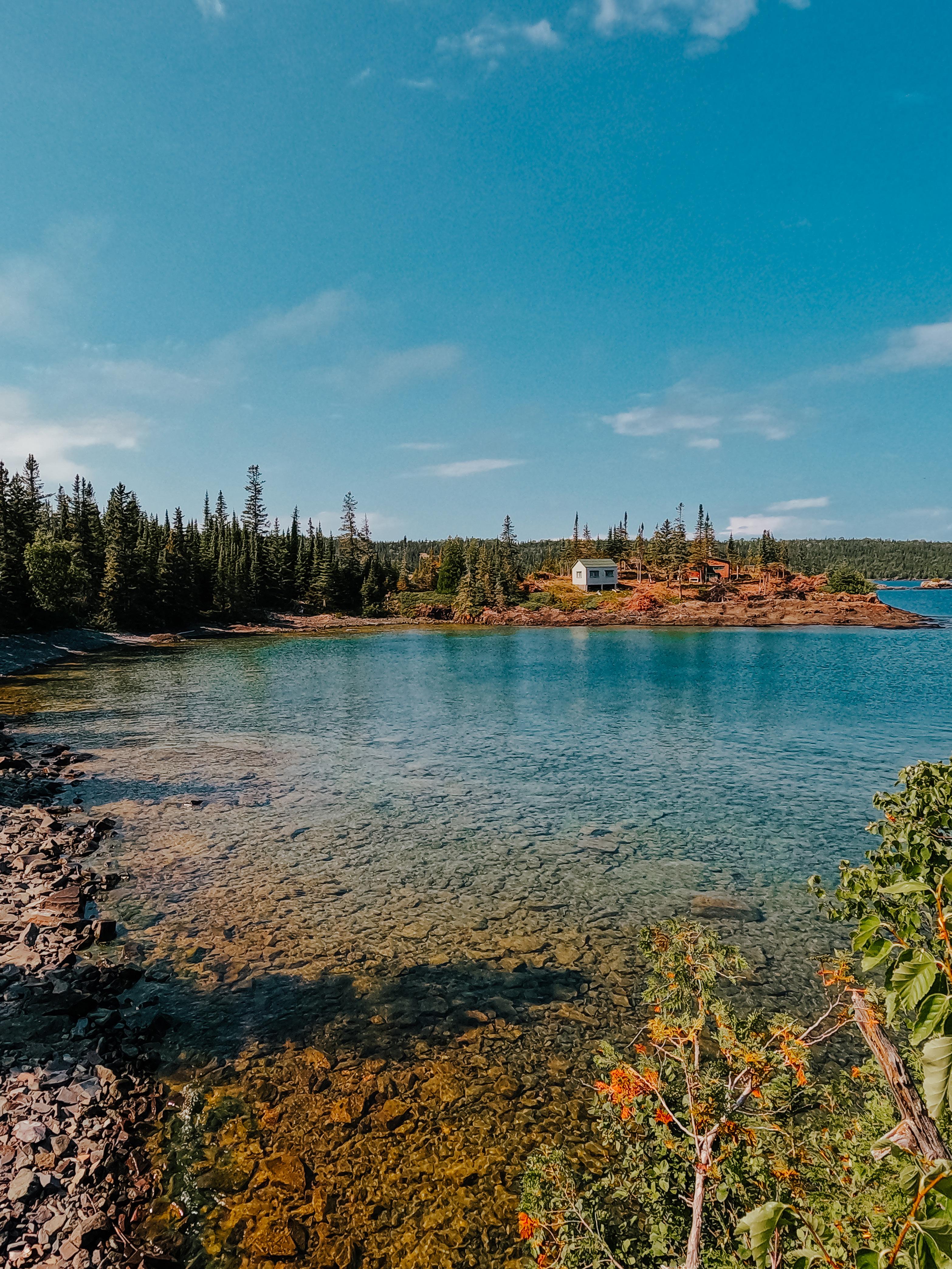
A remote, untouched treasure, seasonally accessible Isle Royale National Park is a rugged, isolated wilderness of forests, lakes and waterways where moose and wolves roam. Journey by private boat, ferry or seaplane, arriving at the park’s southwest end (Windigo, Michigan) or northeast end (Rock Harbor, Minnesota), where the only nontented lodging is found.
The town of Minong and the waters immediately surrounding the archipelago are an important part of the North Shore Ojibwe’s traditional cultural history. They were also part of the Ojibwe’s (Chippewa’s) ancestral land, used for hunting and trapping, as well as fishing, maple sugaring, gathering plants and practicing spiritual traditions.
According to the Ojibwe, the waters off Minong are home to the Mishipeshu, a mythological underwater lynx, both an important and potentially dangerous spirit being. Adding to the park’s allure, dive sites in Lake Superior feature several shipwrecks.
Isle Royale is open annually, from April 16 through October 31. The island is closed November 1 through April 15 due to unsafe, extreme winter conditions, which extend 4.5 miles out from the island into Lake Superior. To preserve its
8 UNITED VAN LINES NATIONAL PARKS GUIDE MIDWEST
MICHIGAN

GETTY
Visiting Isle Royale
PARK OPEN DATES April 16 to October 31
CLOSURE DATES November 1 to April 15
wilderness integrity, vehicles and wheeled devices, with the exception of wheelchairs, are not allowed on Isle Royale. Hiking, boating, canoeing and kayaking are the best — and only — ways to experience its expanse.


THE FLORA AND FAUNA
Having once crossed an ice bridge between Isle Royale and the Canadian mainland, park residents include red foxes, otters, beavers and massive moose. Gray wolves have also populated the park since the late 1940s.
Integral to the ecosystem, wolves help stabilize the moose herd, as they prey on the old, young, ill and injured among them. Moose provide stable winter hunting for the wolves, leading to the species’ dramatic comeback. Joining them are a wide array of amphibians, mollusks, birds and insects,
some rare and others found only in the park’s inland lakes or streams.
Isle Royale is also home to over 600 flowering plants, including a number of rare species. Mosses form lush carpets, while nearly 30 species of ferns flourish and 600 different species of lichen cling to bedrock and balsam firs.
THE WEATHER
Featuring a moist continental climate, Isle Royale sees comfortable summers and frigid, snowy winters. Generally, it’s partly cloudy year-round, with temperatures that fluctuate between -1 F and 76 F. Wondering about the best time of year to visit? It depends on what experience you seek, though warm-weather activities are best enjoyed from early July through late August.
10 UNITED VAN LINES
GUIDE MIDWEST
NATIONAL PARKS
GETTY
GETTY
Stay Prepared in Isle Royale National Park
When setting out for hikes on the island, it’s extremely important to have the following, as rescue support is limited:
Plenty of drinking water
Snacks
area between the forest and Lake Superior shoreline.
GREENSTONE RIDGE TRAIL
Rigorous and lengthy, the point-topoint, 39.5-mile Greenstone Ridge Trail from Windigo to Tobin Harbor is the park’s longest and most varied. It typically takes between four and five days to hike in its entirety. Taking you through dense boreal forest and damp, thigh-high ferns, it travels up and down basalt ridges to the 1,394-foot pinnacle of Mount Desor, with beautiful viewpoints and wildflowers en route.
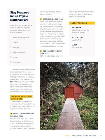
ROCK HARBOR TO DAISY FARM TRAIL
A 6.7-mile out-and-back option, the
Rock Harbor to Daisy Farm Trail offers scenic views along the Rock Harbor Channel and Mott Island.
ABOUT THE PARK LOCATION
Lake Superior, near the Canadian border
ESTABLISHED
April 3, 1940
AREA
132,018 acres
On and around Isle Royale, consider all surface lake and stream water contaminated and non-potable. You’ll find helpful information about safely treating water in the backcountry here. Additionally, always check both land and water conditions on the park’s website, and with a reliable weather service, as conditions are temperamental and quickly change
THE HIKES, DRIVES AND VIEWPOINTS
Isle Royale is 45 miles long and nine miles wide, with an area of nearly 207 square miles, making it the fourth largest lake-island in the world.
SCOVILLE POINT VIA STOLL MEMORIAL TRAIL
For spectacular views, the 4.7-mile Scoville Point via the Stoll Memorial Trail is a moderately challenging but rewarding hike that winds to the northeast from Rock Harbor, Michigan,

MIDWEST UNITED VAN LINES NATIONAL PARKS GUIDE 11
A map A compass
Rain gear First aid essentials

GETTY

GETTY
Voyageurs National Park Minnesota NATIONAL PARKS OF
Voyageurs National Park

Set at the Canadian border in International Falls, Minnesota, 218,055-acre Voyageurs National Park offers year-round enchantment, from its rock ridges and cliffs to its wetlands, southern boreal and northern hardwood forests, streams, and lakes.
Featuring both land and aquatic ecosystems, it’s a place where the Northern Lights make a sporadic appearance, eagles soar overhead while wolves roam below. The Ellsworth Rock Gardens on the shores of Lake Kabetogama and the Kabetogama Peninsula feature 200 sculptural delights.
The park’s name is a nod to the French Canadian fur traders who began journeying along the area’s interconnected waterways more
than 250 years ago. But it was during the Paleo-Indian Period that people first entered this area, when the waters from glacial Lake Agassiz receded.
THE FLORA AND FAUNA
With interconnected waterways that flow west and, eventually, north as part of the Hudson Bay’s arctic watershed, Voyageurs is part wild, part developed. Located at the southern end of the Canadian Shield, it reveals some of the world’s oldest rocks.
Home to iconic Northwoods species — among them moose, several wolf packs, black bears, bald eagles and owls — its wetlands are also a haven for beavers and amphibians. Roughly 40% of the park is water — it’s also populated with walleye, northern pike,
lake trout and sturgeon.
Boreal tree species from the north — spruce, fir, aspen and paper birch — mingle with maples, oaks, pines and basswood from the south and east. Time it right and strawberries, blueberries and raspberries abound.
THE WEATHER
Experiencing four distinct seasons, the weather is most temperate June through August. The park remains frost-free an average of 120 days from June to mid-September.
Fairly rainy and snowy, annual precipitation — including rain and snow — averages 25 to 28 inches. The snowfall varies but is usually between 55 and 70 inches.
Keep an eye on trail and weather conditions on the park’s website.
14 UNITED VAN LINES NATIONAL PARKS GUIDE MIDWEST
MINNESOTA GETTY

TIM UMPHREYS
THE HIKES, DRIVES AND VIEWPOINTS
BLIND ASH BAY TRAIL
Narrow, winding and rocky, the 3-mile Blind Ash Bay Trail cuts through the boreal forest, with ample opportunities to spot wildlife, such as deer and a variety of birds.
OBERHOLTZER TRAIL
The 1.7-mile out-and-back Oberholtzer Trail travels through deciduous and conifer forest before twisting through a cattail-dotted wetland and past rocks that were left by ancient glaciers.
KABETOGAMA LAKE TRAIL
Fringed by pine trees, the .4-mile
Kabetogama Lake Trail is an easy option with excellent lake vistas.
BEAVER POND OVERLOOK TRAIL
Another non-strenuous choice is the .3-mile, out-and-back Beaver Pond Overlook Trail, a short, uphill hike that culminates in a view of its namesake.
WATERS OF THE DANCING SKY SCENIC BYWAY
Opt to take Minnesota’s northernmost scenic drive — Waters of the Dancing Sky Scenic Byway — which travels from Voyageurs National Park along the Canadian border. Motor from Rainy River in International Falls to Baudette, pass through fields of lady’s slippers

from Baudette to Warroad, and follow the Pine to Prairie Birding Trail west of Warroad.
ABOUT THE PARK
LOCATION
Northern Minnesota, near the Canadian border
ESTABLISHED
April 8, 1975
AREA
218,000 acres
16 UNITED VAN LINES NATIONAL PARKS GUIDE MIDWEST
GETTY

KERAN YANG Gateway Arch National Park Missouri
OF
NATIONAL PARKS
Gateway Arch National Park
Set in the city of St. Louis, Gateway Arch National Park serves as a memorial to Thomas Jefferson’s role in opening the west, leading to the westward expansion of the United States in the 19th century; the explorers, pioneers and rebels who helped shape American history; and Dred Scott — and his wife, Harriet — who sued for their freedom from slavery.
Formerly the Jefferson National Expansion Memorial, the national park now consists of the Gateway Arch; an underground visitor’s center beneath it; the Museum of Westward Expansion; and St. Louis’ Old Courthouse, two blocks west of the arch.

THE FLORA AND FAUNA
Set on 91 picturesque acres, Gateway Arch is the smallest national park in the United States. An urban oasis of ornamental turf grass, bald cypress trees, shrubs and flowers, it includes Zen gardens and even a native grass meadow.
Situated between the prolific habitat of the Mississippi River and downtown St. Louis, the park welcomes urban-adapted species, like raccoons, white-tailed deer and Canada geese. Meanwhile, resident birds include mourning doves, northern cardinals, robins, house finches and blue jays. Not to be overlooked are the insects — like Monarch butterflies and buzzing bees — which are crucial to its ecology.
THE WEATHER
St. Louis summers are hot and muggy, while its winters are cold and snowy. On average, the park sees 42 inches of annual rain, most of it falling between May and August, its busiest months. Crowds are much smaller in January and February, though spring ushers in an increase in visitors. Fall is a pleasant time to visit, though crowds can peak, as they do in November and December, when kids are out of school.
Keep an eye on current conditions on the park’s website.
THE VIEWPOINT
A unique conveyance system takes visitors from the lower-level lobby to the top of the arch. Featuring eight five-passenger trains per leg, the capsules run at a rate of 340 feet per minute, a 10-minute ride round trip. From the observation platform at the top, plate-glass windows offer expansive views to the east and west.
18 UNITED VAN LINES NATIONAL PARKS GUIDE MIDWEST
MISSOURI GETTY
Exploring Gateway Arch
About the Arch
Built in the form of a weighted, catenary arch and clad in stainless steel, Gateway is the tallest such structure in the world.

Gateway Arch is as tall as it is wide
Its two legs were built separately. Had their measurements been off by as little as 1/64th of an inch, they would not have joined at the top.
ABOUT THE
LOCATION
St. Louis, on the Mississippi River’s west bank
ESTABLISHED
February 22, 2018
AREA
The Secret Service forbids all presidents from ascending the arch due to safety concerns about the right, enclosed space. The only exception? Dwight D. Eisenhower, who signed the order for its construction in 1954. (Photo: Public Domain)
91 acres

MIDWEST UNITED VAN LINES NATIONAL PARKS GUIDE 19
54’
Each leg of Gateway arch is 54 feet wide at ground level, tapering to 17 feet up top.
PARK
630’
Designed by architect Eero Saarinen, Gateway Arch soars 630 feet into the sky and is 630 feet wide at its base.
PUBLIC DOMAIN
KIRK THORNTON

KIRK THORNTON
NATIONAL PARKS OF

North Dakota
GETTY
Theodore Roosevelt National Park
Theodore Roosevelt National Park

Located in western North Dakota, where the Great Plains meet the rugged badlands, sprawling Theodore Roosevelt National Park memorializes the 26th U.S. president, who began ranching operations in the Dakota Territory after the death of his wife and mother in the late 1800s. However, the park’s cultural history extends back thousands of years.
Whether directly or indirectly, the park is greatly impacted by environmental factors, be it glaciation, ancient swamps and river deltas, or constant winds and sporadic, torrential rainstorms. From its flood plains to its forests, prairies, rivers and streams, it’s a land of stark contrasts filled with fascinating geologic formations, glacial features and fossils.
The region’s historic inhabitants include the Mandan and Hidatsa, whose traditional bison hunting grounds included the Little Missouri River basin.
The Crow used the eastern edge of the badlands, while hunting and trading drew other tribes — such as the Blackfeet, Gros Ventre, Chippewa, Cree, Sioux and Rocky Boy — in the early 19th century.
THE FLORA AND FAUNA
A wide variety of animal species call Theodore Roosevelt National Park home, thanks in no small part to its native grasses, which supply sustenance for large
and small grazing animals. Its varied habitats attract a diversity of birds, while its intriguing terrain results in fascinating microclimates — from warm, dry slopes to cooler, wetter juniper woodland and river bottoms that teem with life.
Visitors may see bison, wild horses and elk, as well as pronghorn, prairie dogs, and white-tail and mule deer. Plenty of reptiles — like bull snakes, prairie rattlesnakes, western painted turtles and short-horned lizards — are residents, too, as are more than 186 types of birds and amphibians, such as boreal chorus frogs and tiger salamanders.
As for plant life, more than 400 species have been identified in the park’s prairies, grasslands, forested and cooler slopes, and dry, south-
22 UNITED VAN LINES NATIONAL PARKS GUIDE MIDWEST
NORTH DAKOTA
facing buttes. Boasting an impressive display of wildflowers, the pasqueflower is the first to bloom, followed later by sunflowers, asters and rabbitbrush.
THE WEATHER
Warm, sunny weather prevails in summer, when temperatures typically are in the 70s F and 80s F. Conversely, winters are cold — in the single digits — from December through February. The park receives an average of 15 inches of precipitation per year, which includes an average of 30 inches of snow during the winter.
Violent thunderstorms in summer and blizzards in winter can occur. Watch for current conditions on the park’s website.
THE HIKES, DRIVES AND VIEWPOINTS
CAPROCK COULEE LOOP
The 4.4-mile Caprock Coulee Loop travels through dry washes, with vistas of the Little Missouri River and vibrant badlands landscape. Wildlife sightings are common along this route, which ascends 730 feet.
WIND CANYON TRAIL
Short and sweet, the family-friendly, .5-mile Wind Canyon
Trail begins at Scenic Loop Road, taking hikers past winderoded cliffs above the Little Missouri River, culminating at a dramatic lookout point over the breathtaking, barren landscape.

PAINTED CANYON NATURE TRAIL
A short hike just off of I-94, the 1.1-mile Painted Canyon
Nature Trail drops down into the canyon, revealing vivid layers of eroded rock and a proliferation of wildflowers and junipers.
BOICOURT OVERLOOK TRAIL
The .8-mile out-and-back Boicourt Overlook Trail is a stunner offering vast panoramas of the rugged, rolling landscape and distant buttes from above.
PETRIFIED FOREST TRAIL
A remote, unpaved backcountry route, the 4.4-mile Petrified Forest Trail lends insight into the park’s geologic past, when it was dominated by shallow swamps and soaring trees. After
MIDWEST UNITED VAN LINES NATIONAL PARKS GUIDE 23
GETTY
FROM ITS FLOOD PLAINS TO ITS FORESTS, PRAIRIES, RIVERS AND STREAMS, IT’S A LAND OF STARK CONTRASTS FILLED WITH FASCINATING GEOLOGIC FORMATIONS, GLACIAL FEATURES AND FOSSILS.
traveling up out of the badlands into a wide prairie, the trail splits, each side taking hikers through a valley filled with petrified stumps.
SCENIC LOOP DRIVE
From the South Unit Visitor Center, putter along 36-mile Scenic Loop Drive through the colorful badlands and prairie dog towns, with many opportunities to spot wildlife. In the North Unit, hook up with the 14-mile scenic drive, which follows the north rim of the Little Missouri River Valley for magnificent views and more chances to see wildlife.
ABOUT THE PARK LOCATION
Western North Dakota, where the Great Plains meet the Badlands


ESTABLISHED
November 10, 1978
AREA
70,446 acres
24 UNITED VAN LINES NATIONAL PARKS GUIDE MIDWEST
GETTY GETTY

MAX ANDREY
Cuyahoga Valley National Park
Ohio NATIONAL PARKS OF
Cuyahoga Valley National Park

ABOUT THE PARK LOCATION
Along the Cuyahoga River, between Cleveland and Akron
ESTABLISHED
December 27, 1974
AREA
33,000 acres
OHIO
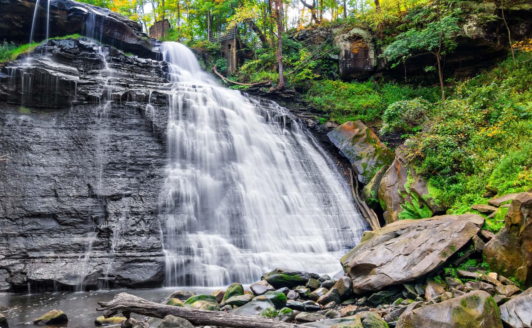
Set along the winding Cuyahoga River, between the urban Ohio cities of Cleveland and Akron, Cuyahoga Valley National Park offers over 125 miles of hiking trails, not to mention a chance to ride on the Cuyahoga Valley Scenic Railroad, a unique way to experience its natural beauty.
With over 12,000 years of human occupation, Native Americans were the first inhabitants, building villages before Europeans established trading posts and New England settlers decided to stay. While the Native American villages, pioneer settlements and canal worker communities no longer exist, remnants throughout the park offer insights into the past.
The 22-mile stretch of river — a riparian habitat — is but one element of the park, joined by deciduous mixed mesophytic forests and wetland habitats.

THE FLORA AND FAUNA
The park has 900 resident plant species, in addition to well over 200 bird species, 32 mammal species, 91 species of aquatic macroinvertebrates, 43 varieties of fish, 22 types of amphibians, and 20 reptile species. Featuring two distinct geographic regions — the Appalachian Plateau and the Central Lowlands — 33,000-acre Cuyahoga Valley welcomes coyotes, red and gray foxes, bats, chipmunks and squirrels, along with deer, beavers and muskrats.
The northern copperhead, endangered spotted turtle and 28 bird species designated “of concern” populate the landscape, too. Look overhead to spot bald eagles or peregrine falcons. Additionally, there are three heronries within.
A stroll through the forests and fields reveals many of the park’s 943
MIDWEST UNITED VAN LINES NATIONAL PARKS GUIDE 27
MAX ANDREY
plant species, be it bloodroot and spring beauty on the forest floor or late summer stands of goldenrod and wingstem that line roadways.
THE WEATHER
Warming springs and humid summers, ranging from 49 F to 95 F, make layering one’s attire a must. Fall temperatures can vary significantly, too, ranging from the low 70s F during the day to freezing at night. Winter weather has the potential to change rapidly on account of lake effect snow from Lake Erie, when temperatures hover between the mid-30s F to below zero.
Check the park’s website for current conditions and closures.
THE HIKES, DRIVES AND VIEWPOINTS
LEDGES TRAIL
Offering the best panoramas of the park — including of its sandstone layered rock “ledges” — the 2.3-mile Ledges Trail takes you through mossy passageways and to an overlook with views for miles.
BRANDYWINE GORGE TRAIL
A 1.4-mile loop near the town of Hudson, the Brandywine Gorge Trail, when taken clockwise, takes you down into the gorge, back up the other side, over the falls and to a viewing
boardwalk to see it plummet and hear its roar.
STANFORD TRAIL
Consider taking the 3.9-mile Stanford Trail, one of the most popular in the park, to see the historic 1843 Stanford House, a raised, three-bay barn.
BLUE HEN FALLS TRAIL
Mostly made of dirt, the 2.4-mile Blue Hen Falls Trail — via the Buckeye Trail from Boston Mill — begins with a 200-foot climb and zigzags through the forest before descending to the picturesque waterfall. Expect a steep, 580-foot change in elevation.

PINE GROVE & FOREST POINT TRAILS
Combine the Pine Grove and Forest Point Trails for a familyfriendly, 2.7-mile trek through wooded deciduous greenery, hemlocks and a stippling of wildflowers swaying amid switchgrass.
RIVERVIEW ROAD SCENIC DRIVE
Looking for a pretty drive? Riverview Road Scenic Drive — or County Road 9 — extends nearly 20 miles through the park, revealing some of its greatest vistas. Picnic areas, waterfalls and visitors centers are accessible just off the route. You can also park and take a ride on the Cuyahoga Valley Scenic Railroad; its tracks are visible from the road.
28 UNITED VAN LINES NATIONAL PARKS GUIDE MIDWEST
GETTY

LUKE WASS
Dakota NATIONAL PARKS OF
Badlands National Park South
Badlands National Park
A wilderness of layered rock formations, soaring spires and steep canyons, wild and wonderful Badlands National Park spans 242,756 acres in southwestern South Dakota.


Archaeological finds show people have been in and around the badlands for as long as 12,000 years. The park’s South Unit is located entirely on tribal trust land, held in trust by the federal government for the use and benefit of Oglala Sioux tribe members. However, a great number of associated tribes have histories throughout the park’s natural and cultural landscape. Later, homesteaders moved to the Midwest in search of a new life, some ultimately settling in the scenic surrounds.
Situated in a mixed-grass prairie ecosystem, the ever-changing, deeply eroded expanse of buttes, pinnacles and spires — deposited as early as 75 million years ago — reveal fossilized remains buried in the rock beneath.
THE WEATHER
Weather is known to change quickly in the badlands, with highly variable, extreme temperatures that range from 116 F to -40 F. June is the wettest month and violent thunderstorms can occur during hot, dry summers. Meanwhile, the badlands are no stranger to hailstorms; the occasional tornado can occur; and winter typically brings
THE FLORA AND FAUNA
A place at once striking and stark, ancient horses and rhinos once roamed here. Today, the badlands welcome bighorn sheep, pronghorn, bison, blackfooted ferrets (one of North America’s most endangered animals) and comical, curious — not to mention vocal — prairie dogs, who pop up from holes in the ground. Meanwhile, birds of prey coast overhead in search of their next meal, perhaps venomous, thermosensitive prairie rattlesnakes. Roughly 206 bird species and 69 documented species of butterflies and amphibians — from frogs to toads — have also been found in Badlands National Park.
30 UNITED VAN LINES NATIONAL PARKS GUIDE MIDWEST
SOUTH DAKOTA
GETTY
STEPHEN PENDERSEN
12 to 24 inches of snow. Because changes in weather can be both sudden and dramatic, it’s important to dress in layers, wear protective sunblock and carry adequate water for hiking. Always check weather conditions on the park’s website to help prepare for visits.
THE HIKES, DRIVES AND VIEWPOINTS
NOTCH TRAIL
Wind through a canyon and climb a log ladder, following a ledge to vistas of the White River Valley on the 1.5-mile, out-and-back Notch Trail, the park’s most popular hike. Note, however, that it’s treacherous during or after heavy rains or snow.
THE DOOR TRAIL
Set out on a .9-mile hike along The Door Trail, where a boardwalk leads to an opening in Badlands Wall, revealing a rugged, otherworldly landscape.

THE WINDOW TRAIL
Requiring caution and a climb of 900 feet, 5.5-mile The Window Trail drops into Oak Creek Canyon to the pouroff, with its spectacular desert vistas. Depending on conditions, Oak Creek may be flowing and therefore must be crossed several times. Note that the top of the pour-off is slickrock, without railings.
SADDLE PASS TRAIL
Climb up the Badlands Wall for views over White River Valley on the .7-mile Saddle Pass Trail, where it’s possible to connect with the Castle and Medicine Root Loop Trails. While among the park’s shorter trails, it’s also one of the steepest, with a 300-foot change in elevation.
SOUTH DAKOTA HIGHWAY 240
Don’t skip the surreal, 39-mile loop drive on South Dakota Highway 240, between the towns of Cactus Flat and Wall. It’s so dramatic — and so thrilling — it has been featured in driving video games. With 16 overlooks, view everything from the Pinnacles to the Burns and Conata Basins, as well as the Yellow Mounds, bands of yellow, orange and beige rock from a drained, ancient sea.
LOCATION
Near the Black Hills, east of Rapid City
ESTABLISHED
November 10, 1978
AREA
242,756 acres
MIDWEST UNITED VAN LINES NATIONAL PARKS GUIDE 31
ABOUT THE PARK
Wind Cave National Park
Tucked into the southwestern corner of South Dakota, Wind Cave National Park is best known for containing one of the longest, most complex cave systems in the world. In the subterranean passages, watch for boxwork, a unique, rarely seen formation. Made of thin blades of calcite that project from cave walls and ceilings, it forms a honeycomb pattern.
Above, an intact prairie and ponderosa forest is intersected by hiking trails. Incredible Black Hills scenery creates a home for some of North America’s most iconic wildlife. Meanwhile, prairie dog towns — or colonies — offer sightings of these entertaining, social creatures.

A place of mystery and abundant oral history, native people called the Black Hills home since time immemorial.
THE FLORA AND FAUNA
A tale of two vastly different worlds within the park’s boundaries, its cave is a seldom-seen mix of needle-like frostwork; knobby cave popcorn; rare boxwork; stalactites; stalagmites; dogtooth spar crystals; and flowstone.
Above ground, bison, elk and pronghorn live among American bison,
32 UNITED VAN LINES NATIONAL PARKS GUIDE MIDWEST
SOUTH DAKOTA

GETTY
endangered black-footed ferrets, elk, mule deer, coyotes and secretive bobcats. Challenging as the environment may be, several species of reptiles and amphibians — from trilling frogs to poisonous prairie rattlesnakes — are residents.
Vanilla-scented ponderosa pines give way to prairie grasses and delicate wildflowers. Punctuated by white sego lilies, purple coneflowers and cheery sunflowers, the flora is an unexpected feast for the eyes.
THE WEATHER
Generally semi-arid, with mild winters and warm summers, Wind Cave’s weather is greatly influenced by the Rocky Mountains to the west, as well as the high peaks of the northern Black Hills. It’s significantly warmer and drier than
the northern hills, even when arctic air masses move south from Canada.
The winter snowfall averages 30 inches. Spring and fall days alternate between warm and sunny, cool and windy, and rainy. Summer ushers in warm daytime temperatures and cool evenings, with oft-occurring, severe thunderstorms, hail and lightning in June and July.
Be cautious of flash-flooding and keep an eye on weather conditions on the park’s website.
THE HIKES, DRIVES AND VIEWPOINTS
GUIDED CAVE TOURS

No visit to the park is complete without taking a guided tour of
ABOUT THE PARK
LOCATION
Southwestern corner of South Dakota
ESTABLISHED
January 9, 1903
AREA
33,847 acres
GETTY
the cave. Options include the hour-long Garden of Eden tour; the slightly longer North Entrance tour; or the strenuous Fairgrounds tour, a lengthier chance to view boxwork; frostwork and cave popcorn, with steep stair climbs.
RASKIN RIDGE
INTERPRETIVE TRAIL
The 1-mile Raskin Ridge Interpretive Trail is a short, stunning hike to the highest point in the park, with expansive views of Badlands National Park and Buffalo Gap on clear days.
LOOKOUT POINT & CENTENNIAL LOOP TRAILS
Combine the Lookout Point and Centennial Loop Trails for a 5.2-mile taste of the 113-mile Centennial Trail, which runs from Bear Butte to Wind Cave National Park. A narrow trek mostly upon slickrock, it features a lookout from the park’s pinnacle and vast views across mixed-grass prairie and ponderosa forest.
COLD BROOK CANYON TRAIL
A 2.8-mile out-and-back trail near Custer, the 2.8-mile Cold Brook Canyon Trail winds through its namesake, with opportunities to glimpse raptors and prairie dog colonies.

WIND CAVE CANYON TRAIL
The 3.8-mile out-and-back Wind Cave Canyon takes hikers along an old road to the park’s boundary, seeing limestone cliffs, which are nesting habitats for cliff swallows, canyon wrens and great horned owls.
US HIGHWAY 385 & SOUTH
DAKOTA HIGHWAY 87 DRIVES
Both U.S. Highway 385 and South Dakota Highway 87 — the two main roads through the park — afford scenic drives with pull-outs for appreciating the landscape and spotting wildlife.

GETTY
GETTY
36 UNITED VAN LINES NATIONAL PARKS GUIDE MIDWEST
© 2023 United Van Lines, LLC