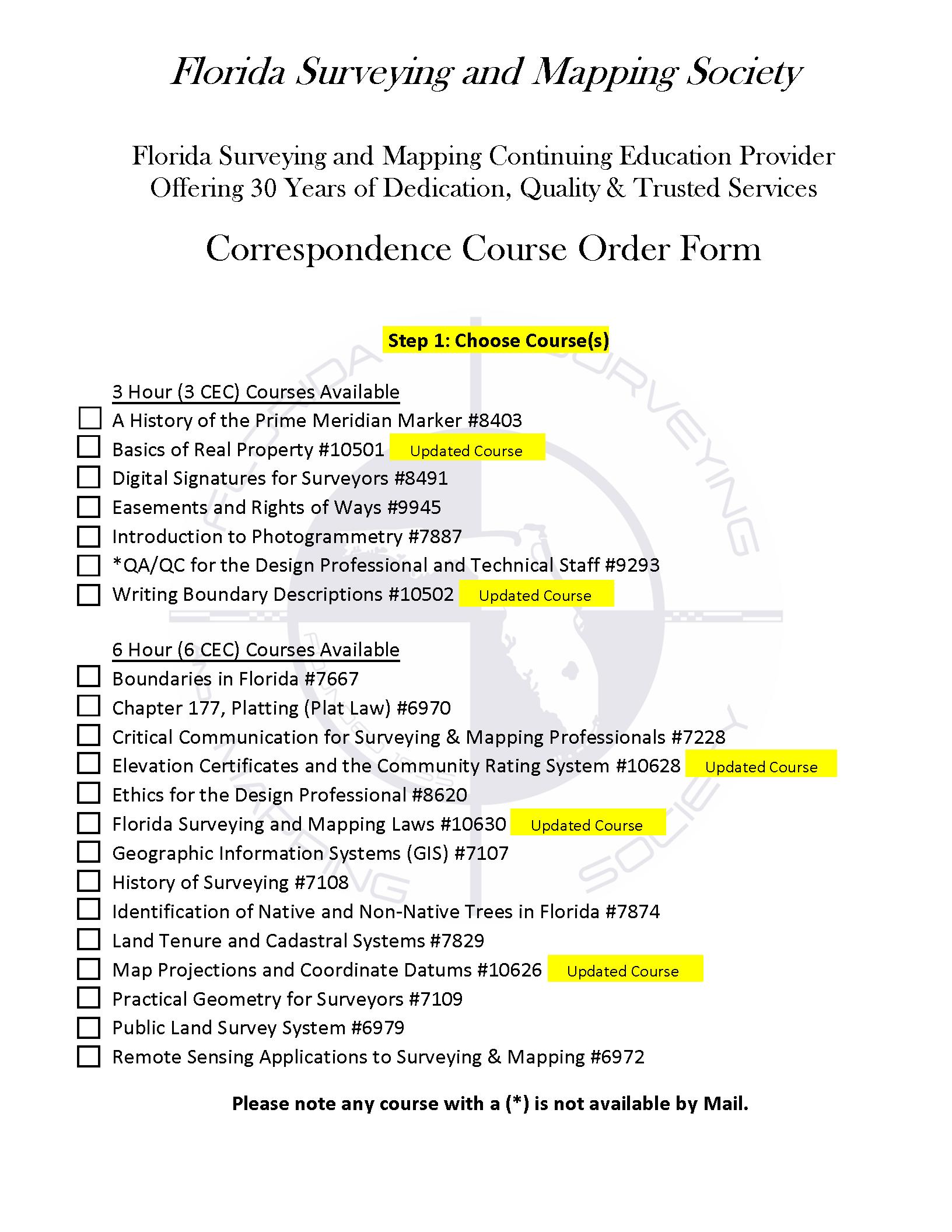
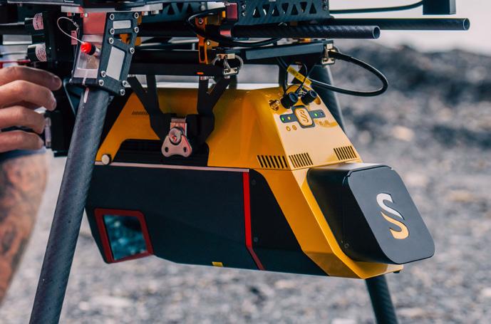
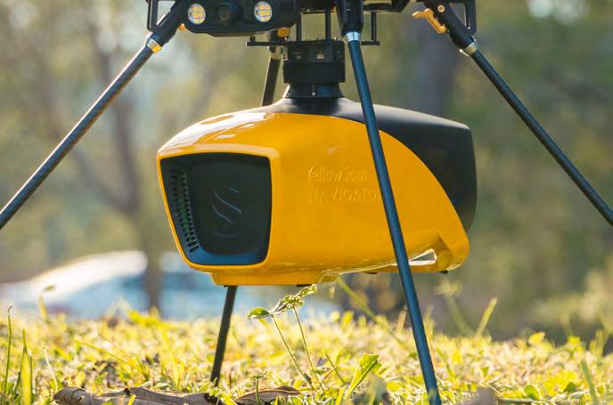
Call us t o g et your complete work flow s olution today ! Efficiency and versatility that will accelerate productivity comes part of a workflow solution that includes the FC-6000 field controller, Magnet software, a HiPer VR receiver and the GT-1200/GT-600 single-operator robotic system. The power of longrange reflectorless measurements comes in your choice of 1”, 2” or 3” GT-1200 models or 2”, 3” or 5” GT -600 models.
The F lorida Surveyor is the official publication of the Florida Surveying and Mapping Society, also known as FSMS. It is published monthly for the purpose of communicating with the professional surveying community and related professions who are members of FSMS. Our award winning publication informs members eleven months out of the year about national, state, and district events and accomplishments, as well as articles relevant to the surveying profession. In addition, continuing educational courses are also available.
PRESIDENT’S Message
November
2025
Members,
Our first board meeting was held November 7th, and we had a productive discussion on numerous topics. One of those topics was the Strategic Plan. The Strategic Plan is just that; it is a plan to strategically navigate our society with a well rooted direction. This plan is updated periodically to adjust course as needed. This year I feel it is time to review and re-focus our efforts for the future, and we need your help to do this. We previously published the plan in the October 2024 issue . I encourage you to refer back to it and see what has been submitted and where we can improve. Our next board meeting is scheduled for early February, so any suggestions need to be returned by January 31st.
Our scholarship committee awarded scholarships to five individuals. I would like to congratulate the following students and wish them well in their future endeavors: Wesley Asmus, Joshua Maxwell, Paul Domke, William Fouts, and Brianne McGuire.
The venue for next year’s Conference has been finalized and will be the JW Marriott Miami Turnberry in Aventura. The dates for conference will be from July 29th through August 1st. Room rates (including resort fees ) will be $240 per night.
Renewal notices were sent out this month. Please take the time to send in your renewals. Don’t forget to look at the groups and optional donations opportunities:
• Geospatial Users Group – is an education and outreach group of the Florida Surveying and Mapping Society that is dedicated to educ ating
PRESIDENT’S Message
professionals in the Surveying, GIS, Photogrammetric and Mappin g professions.
• Young Surveyors Network – is an organization created for Young Surveyors and was developed to build networks and grow relationships for surveyors under the age of 39 or who recently graduated.
• Disaster Relief fund – is solely funded by member donations and distributed to those in need after a disaster occurs.
• FSMS scholarship fund – devotes its resources to assist deserving students needing financial aid to obtain an education in the field of land surveying and other businesses and professions connected therewith.
• FSMSPAC - formed to assist the legislative and political efforts of the Florida Surveying and Mapping Society. Without regard to political pa rty affiliation, contributions and support are made to state and local candidate s and political parties that share the views of Surveyors and Mappers on issues and initiatives important to the profession.
Thanksgiving is upon us, and as you may know, it is a holiday t hat invites us to recognize the good things in our lives. With the recent devasta tion caused by Hurricane Melissa in Jamaica, I encourage you, if you are able, to donate to a verified relief organization. Every little bit helps.
As I always close my message, this is your society. Your opinio n matters, and I would like to hear from you regarding any comments or suggestio ns you may have. Please email me at president.fsms@gmail.com .
Respectfully submitted,
Robert N. “ Bob ” Johnson, PSM, CFM
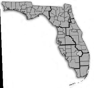
2025-26 Districts and
Directors
District 1 - Northwest
Bay, Calhoun, Escambia, Franklin, Gadsden, Gulf, Holmes, Jackson, Jefferson, Leon, Liberty, Madison, Okaloosa, Santa Rosa, Taylor, Wakulla, Walton, Washington
Chad Thurner (850) 200-2441 chad.thurner@sam.biz
Angela Bailey (850) 559-5039 bailey.angelakay@gmail. com
District 2 - Northeast
Alachua, Baker, Bradford, Clay, Columbia, Dixie, Duval, Gilchrist, Hamilton, Lafayette, Levy, Marion, Nassau, Putnam, Suwannee, St. Johns, Union
Pablo Ferrari (904) 219-4054 pferrari@drmp.com
Nick Digruttolo (352) 374-2249 ndigrutt@gmail. com
District 3 - East Central
Brevard, Flagler, Indian River, Lake, Okeechobee, Orange, Osceola, Seminole, Martin, St. Lucie, Volusia
Howard Ehmke (772) 206-4650 hehmke@carterassoc.com
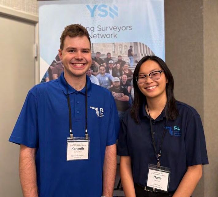
Two of our Florida YSN officers, Kenneth Dell SIT (Treasurer) and Marla Horn (Marketing), traveled up to Minneapolis, MN for the Joint NSPS Young Surveyors Network (YSN)/FIG Young Surveyors Network - Americas Region Mee ting.
It was inspiring to connect with such a motivated community of young survey professionals, each with their own unique experience on entering and navigating through their geospatial careers. Thank you so much for having us, we can't wait for the next one!
NCEES 2025 AWARD RECIPIENTS
Pamela Nobles, P.S.M., of Florida, has been awarded the NCEES Distinguished Examination Service Award for her dedicated service to NCEES and the surveying profession. Nobles was recognized on August 21, 2025, during the organization’s 104th annual meeting in New Orleans, Louisiana.
Nobles has been serving NCEES as a volunteer for the Fundamentals of Surveying (FS) Exam Development Committee for over 20 years. During this time, Nobles has dedicated herself to contributing her extensive expertise to the development and administration of the FS exam.
Additionally, she has served on several professional activities and knowledge studies, or PAKS, to update the FS exam specifications and has served on the NCEES Surveying Exam Module Task Force, which was instrumental in bringing about the PLSS exam. Nobles has also served as a member of the NCEES Committee on Examination Audit, the Committee on Examinations for Professional Surveyors, the Committee on Member Board Administrators, and the CPC Task Force. She has continued her service to the profession by providing seminars for local teachers, promoting her state society, participating in national geospatial organizations, and visiting college students to promote surveying. Nobles is an emeritus member of the Florida Board of Professional Surveyors and Mappers.
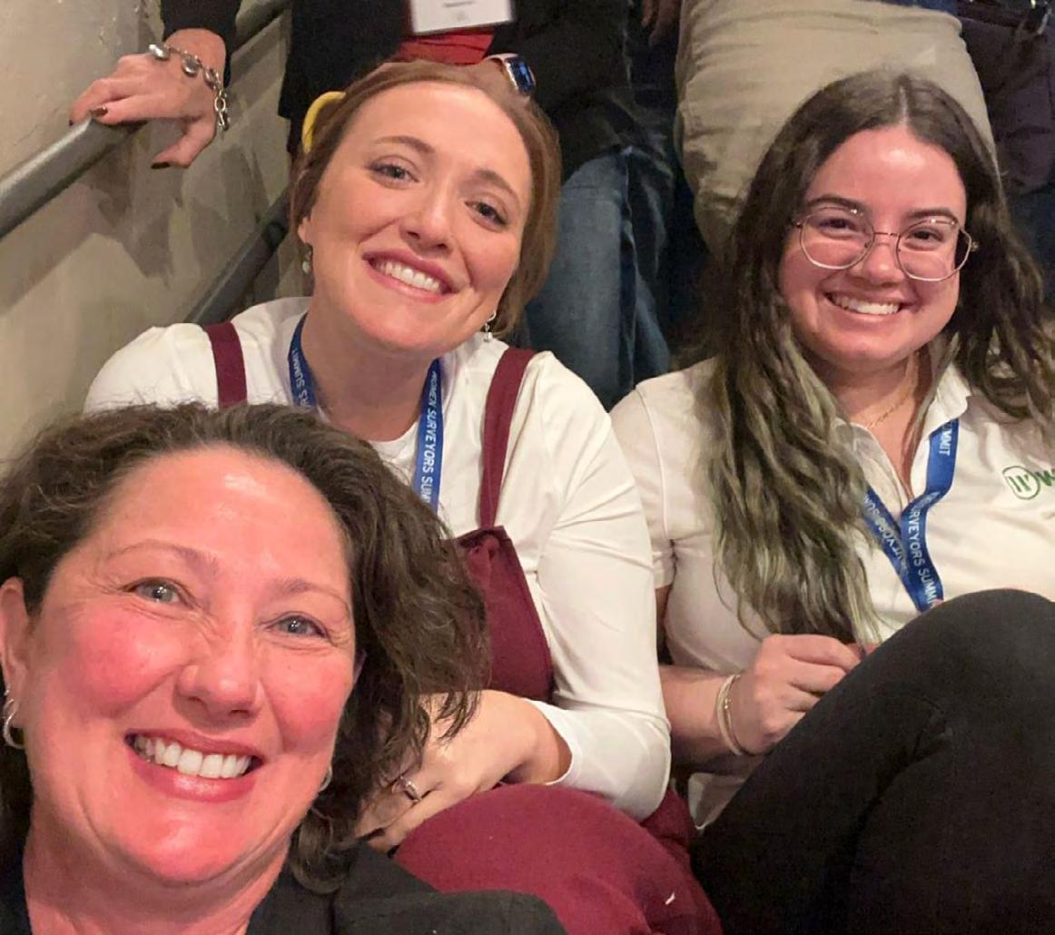
Florida Young Surveyors Network
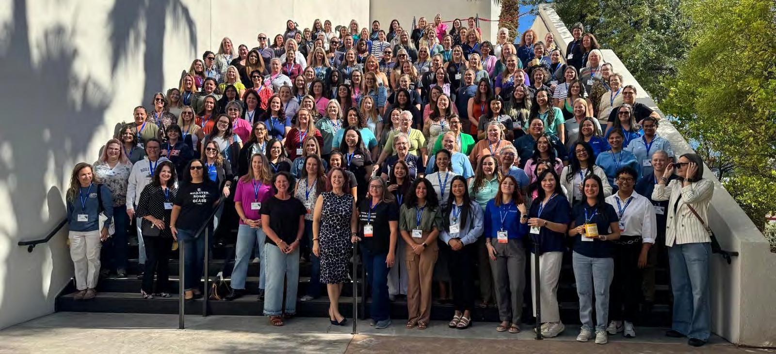
Check out our FL YSN - FSMS Membership Committee Representative, Coral Kuebler, at the 2025 Women Surveyors' Summit in Las Vegas!
“ This year marked my third Women Surveyors’ Summit, and every year I walk away more inspired than the last. What started as a professional event has truly become something much deeper. The friendships and connections I’ve made through this community have impacted my life, not just my career.
This year’s summit brought together over 170 women surveyors from all over the country — including three from my own company, Bowman Consulting — Dana Klett, P.L.S., sUAS Remote Pilot, Maria Barboza, and I! It was amazing to share this experience with such strong and talented women from our Bowman team.
A special shoutout to Peta Cox from Australia and The Geoholics podcast — if it weren’t for your sponsorship my first year, I never would have met this incredible group of women who continue to lift and inspire me. Getting to give Peta a big hug in person this year was truly one of the highlights of my trip!
I also want to take a moment to recognize some of my mentors and role models who continue to shape me both personally and professionally — Trisha Lund-Wittig, Nancy DeeDee Frasure, and Angela Bailey, PSM, PLS just to name a few — thank you all for your guidance, wisdom, and friendship.
And last but not least, a huge thank you to the Future Surveyors Foundation — Anna Rios, RPLS, Heather Markley (Sides-Passmore), and Alicia Tabachnick, PLS, for putting together another incredible event. You ladies make it happen every single year, and it shows.
I’m walking away from this year’s summit feeling renewed, inspired, and ready for anything the future holds! Here’s to empowering one another and continuing to elevate women in surveying.”
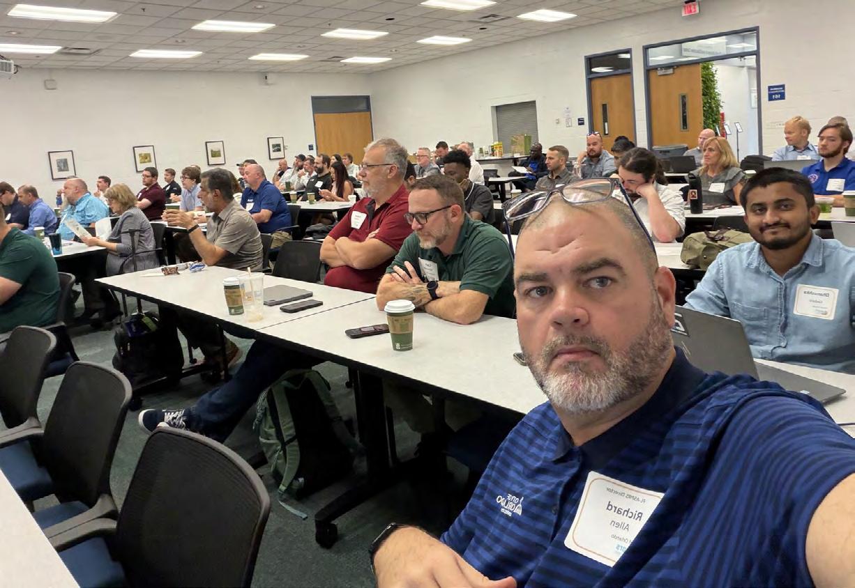
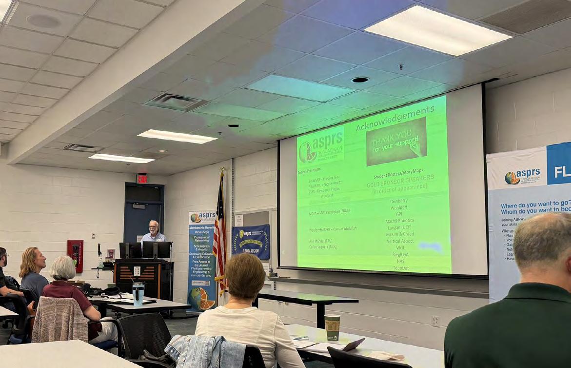
Richard Allen, PSM, CFM (City Surveyor at City of Orlando)
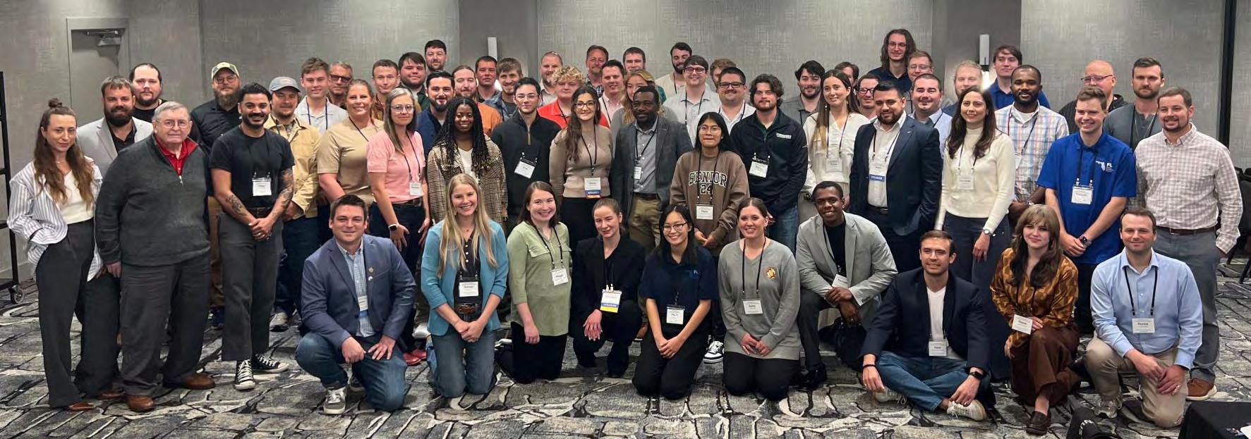
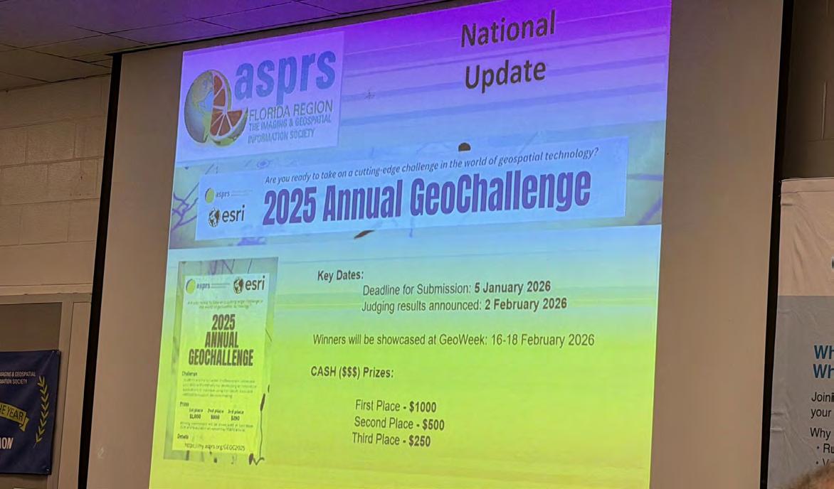
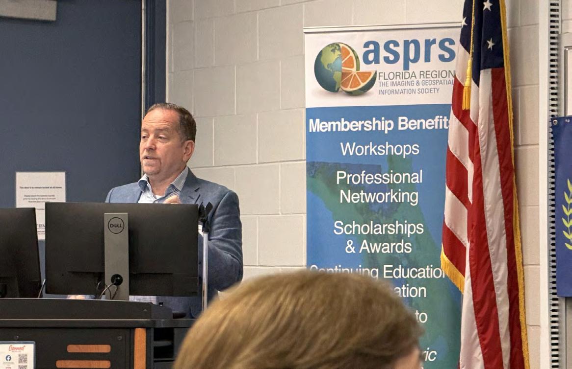
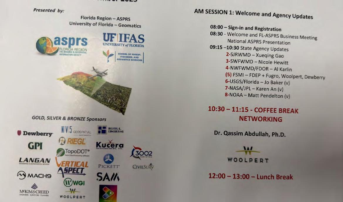
Attending the Fall ASPRS Florida Workshop.
Excellent attendance today!! ASPRS - Florida Region - American Society for Photogrammetry and Remote Sensing (ASPRS) Representing City of Orlando and Florida Surveying and Mapping Society. I look forward to the collaboration and learning between all of the government partners from Federal, State, and local jurisdictions; educational partners and students, and private industry. Such a great group to be a part of for education and outreach.
Dr. Youssef Omar Kaddoura, Al Karlin, Nick Kules, Rick Householder, Barbora Ubar, Matt LaLuzerne, Stephen Medeiros, Brian Murphy, Russell H., Meagan Anderson, and Joe Aufmuth.
Dr. Youssef Kaddoura (Geomatics
Specialist at UF | Geomatics Sciences
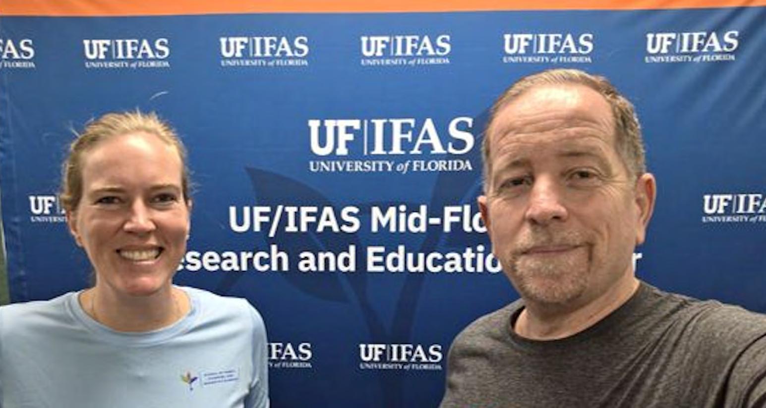
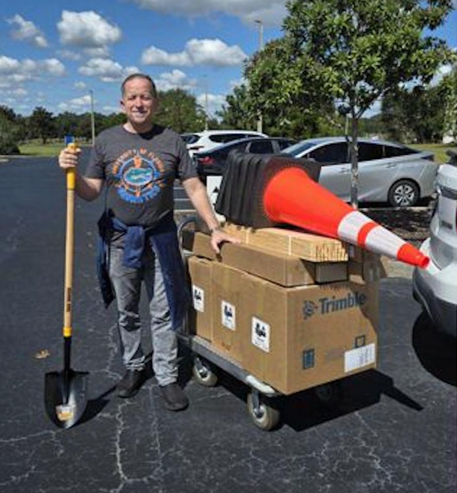
On October 16th, we received our shipment of cutting-edge equipment from Duncan-Parnell Inc. The arrival to UF IFAS Mid-Florida Research and Education Center coincided with a visit from Katie Britt – the perfect opportunity to test the hardware side-by-side, review specs, and start planning how we’ll integrate it into our next generation of labs.
A big thank-you to the Earl Soeder and Duncan-Parnell Inc. team for their timely delivery and support. We’re excited to experiment with these tools and look forward to seeing their impact on our research and student training.
Richard Mark Ritz
December 2 nd , 1952 – July 15 th , 2025
It is with sincere sadness that we announce the passing of Richard “Rick” Mark Ritz, of Fort Myers, Florida. Rick passed on July 15, 2025, surrounded by his loving family, leaving many with cherished memories of a beloved man and an influential contributor to the land surveying and mapping profession. He leaves behind his wife, Linda, two daughters Erin Velotti (son-in-law RJ) and Sarah Ritz, his granddaughter, Rowan Martin, and two grandsons, Ralphie and Rocco Velotti.
Rick was a Florida Registered Land Surveyor (LS 4009) for over forty years. His earliest beginnings in his career started at Howell F. Davis & Associates in the 1970’s, later becoming Bean, Whitaker, Lutz & Kareh (Barnes), where he worked his way from a chainman to a licensed office manager. In 1996, he moved on to become the Director of Surveying and Vice-President at Banks Engineering, now Atwell, LLC, where he continued to practice. He received his
State of Florida surveying license in 1983 and dedicated his life-long career to serving our profession. He employed and inspired countless surveyors over the years in the State of Florida.
Throughout his career, he was a proud sponsor of the Florida Surveying and Mapping Society, and an advocate for recruiting new members. He was recently the recipient of the FSMS “Fellow Member” award in 2024. He served on the Board of Directors for District 5 and was the recipient of the Jim Bennett Board Member of the Year Award (2012-2014), served as President, VicePresident, and Secretary of the Collier-Lee Chapter, and the recipient of the President of the Year award.
Rick stood as a pillar for leadership and wisdom among his colleagues and peers. He was a man of few words, and those words carried weight in any conversation and will continue to inspire the future. His kind-heartedness and generosity, set an example to which all could inspire. His legacy will live on in the cherished memories of all who knew him.
In lieu of flowers, the family asks that memorial contributions be made to an organization and cause Rick greatly cared for, the Harry Chapin Food Bank. Donations can be made in any amount and in his name at the following link: https://harrychapinfoodbank.org/
Cody “Wyatt” Syfrett
February 16 th , 1996 – October 26 th , 2025
Cody “Wyatt” Syfrett, 29, of Rockledge, Florida, passed away on October 26, 2025, with his girlfriend, Kaitlynn, by his side—doing what they both loved most.
Born on February 16, 1996, to Ed and Sandy Syfrett in Merritt Island, Wyatt was a lifelong resident of Brevard County and a proud Cocoa High School graduate, Class of 2014. Afterward, he continued his education at Eastern Florida State College and the University of Central Florida before beginning a career with Southeastern Surveying & Mapping. Through hard work and dedication, Wyatt worked his way up to become CAD Manager, a role he held with pride since 2014.
Wyatt truly lived life to the fullest. He had an adventurous spirit and a deep love for the outdoors, which he shared with Kaitlynn. Together, they were
inseparable—always finding their next adventure, whether it was hunting, fishing, or spending time with family and friends. Those who knew Wyatt will remember his contagious smile, quick wit, and the way he made everyone around him feel like family.
He had a heart of gold and an incredible gift for making time for everyone—no matter how busy life got. Wyatt loved hiking with his dad, sharing stories, and creating memories on the trail. He cherished quiet moments with his mom just as much, finding comfort and laughter in their time together.
Wyatt will be deeply missed and lovingly remembered by his parents, Ed and Sandy Syfrett; grandmother, Diane Shimp; siblings, Kyle Sheely, Amanda Sheely, and Robyn Hayes; aunts and uncles, Linda and Chuck Frank, Cindy Shimp and Robert Bennett, Kelly Randolph, John and Brenda Shimp, Bonnie and Walter Barnes, Mary Syfrett, and Doris Carter; as well as countless friends who were like family.
Wyatt’s story will continue to live on through the people he loved, the adventures he took, and the memories he left behind. He’ll forever be remembered for his kind heart, his love for the outdoors, and the joy he brought into every room.
In lieu of flowers, the family asks that donations be made to causes close to Wyatt’s heart:
https://www.mightyriverrecovery.org
https://helpthelagoon.org
To honor his memory, the family invites you to listen to Wyatt’s favorite Spotify playlists—music that captures his energy, passion, and love for life:
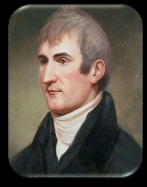
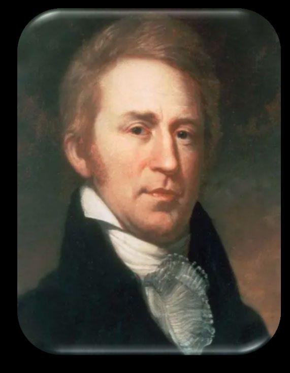
Le wis & Cl ark Expedition (11804-1806) A Surveyor’s Perspective (Part 2)
Part 2 covers portions of the journey, some anecdotes, but mainly delves into the Survey and Mapping done along the route, the survey education Lewis got and passed onto Clark, the notes they took, and instruments they learned and used in their journey.
There have been many articles and studies done regarding this expedition and websites dedicated to it and I have drawn from many of them, as I stated previously in Part 1, for my own research over the past 6 months. The idea of such a journey to find, follow, and map a route through uncharted territory covering almost 8,000 miles from start to finish was unbelievable at the time. Even with the backing and faith of the President of the United States it was a formidable task, something that few men were capable of. Both Meriwether Lewis and William Clark must have been extraordinary men and their journey and the information they collected on everything along the route broadened the knowledge of this area and opened it up to the expansion our great country. These men and all of those who assisted them on this journey were of an extraordinary breed of individuals capable of enduring hardships most of us today would probably fail at, but they didn’t, and they lived to tell the tale for generations to come. Reading through the journals and the multiple websites and stories about the journey has given me a fresh perspective on this expedition and the men who accomplished it…….. Rick Pryce
The real journey begins at the juncture of the Mississippi and Missouri Rivers. They encamped on the east side of the Mississippi River at the mouth of the Wood River during the winter of 1803 due to the Spanish commandant of the province not allowing entry of strangers because he had not yet received word of the transfer of Louisiana to the United States. They therefore decided to wait till spring to start off, spending the time disciplining the crew into what would be expected of them and defining their roles. The party consisted of nine young men from Kentucky, fourteen soldiers who volunteered from the United States army, two French watermen to serve as interpreters and hunters, and a black servant named York, belonging to Captain Clark. All except for York were enlisted to serve as privates for the expedition. Among them, three were appointed to be sergeants by the two Captains. Separate from these permanent crew members, they were joined with a corporal and six additional soldiers and nine watermen to accompany them as far as the Madan Indian nation. They were to assist in carrying the stores of equipment and providing protection against any attack which was possible in the area between the Wood River and the Indian nation. They set sail in three boats, the keel boat, 55 feet long, drawing three feet of water, having one large square sail, and twenty-two oars. This was accompanied by two periogues, open boats, one with six the other with seven oars. Two horses were also being brought, led along the river for game hunting, a constant food supply.
by Richard D. Pryce
May 14th journal entry:
“All the preparations being completed, we left our encampment on Monday, May 14th, 1804. This spot is at the mouth of Wood River, a small stream which empties itself into the Mississippi, opposite to the entrance of the Missouri. It is situated in latitude 38° 55' 19 - 6/10" north, and longitude from Greenwich, 89° 57' 45". On both sides of the Mississippi the land for two or three miles is rich and level, but gradually swells into a high pleasant country, with less timber on the western than on the eastern side, but all susceptible of cultivation. The point which separates the two rivers on the north, extends for fifteen or twenty miles, the greater part of which is an open level plain, in which the people of the neighborhood cultivate what little grain they raise. Not being able to set sail before four o'clock P.M., we did not make more than four miles, and encamped on the first island opposite a small creek called Cold Water.”
On May 15th, they reached the town of St. Charles on the north bank of the Missouri. A town of about 450 inhabitants, mostly French from Canada. Here they remained a few days waiting for Captain Lewis who had been detained in St. Louis on business. They finally set sail again on May 21st and started documenting everything along the river as they went, islands, sand bars, caves, soil, land, trees, and identifying the intersecting creeks and rivers based on mileage and directions from their compass. On May 22nd they encountered a camp of Indians, members of the Kickapoo Tribe, who they spoke with in St. Charles and left before them. They had promised to provide the expedition with some provisions when the they caught up with them. The tribe was true to their word and provided four deer and they exchanged two quarts of whiskey in return. Their documentation of the intersecting waterways included the width and depths and nature of the streams, clear or muddy water, and direction from the Missouri. They also documented the height of the river each day as they proceeded, marking as to whether it rose or fell during each night On May 24th they reached their first rapid along the Missouri, it was named “The Devil’s Race Ground” as it had a very fast current and projecting rocks along the south side. The keel boat almost overturned in trying to pass through there and if not for the crew jumping overboard to right the boat it could have been worse. Just one of the hazards they would encounter on their journey as the “Corps of Discovery”.
On Friday June 1st, 1804, they set out early and only made thirteen miles to the mouth of the Osage River. Because of the current and wind, they camped there and stayed an additional day for the purpose of making celestial observations. June 2nd, this being the first time it is noted in the journal of these observations since they started.
Clark Journal Entries as written:
“June 2nd Saturday 1804, Took equal altitudes & Meridian altitudes also, Cap Lewis Took the Time & Distance of suns & moons nearest limbs, the Sun East and Meridian altitude of Suns U. L. with Octant, back observation gave for altitude 37° 28"00". Error of Octant 2° 00' 00" +. made Several other observations.” “June 3rd Sunday 1804, the forepart of the day fair took meridonal altitude of suns U:L with the Octant and Glass Horrison adjusted back observation. The instrument gave 38° 2’ 00” – it was cloudy and the Suns disk much obscured, and cannot be depended on”
The measuring of equal altitudes was to check and correct the chronometer, the meridian altitudes were taken to calculate the Latitude. It’s noted here that they have now traveled about one hundred and thirty-three miles from their starting point. They go on to describe the Osage River as running generally east-west and empties into the Missouri. The Missouri at this point is roughly eight hundred and seventy-five yards wide and the Osage is about three hundred and ninety-seven yards wide. The low point of the juncture of the two rivers was determined to be at latitude 38° 31’ 16” based on their observations.
On July 22, 1804 Lewis makes his most definitive description of the equipment and the methods he employs for the celestial observations using techniques and devices he made according to the training he had gotten from Andrew Ellicott and Robert Patterson back in Lancaster and Philadelphia.
July 22nd 1804. A summary description of the apparatus employed in the following observations: containing also some remarks on the manner in which they have been employed, and the method observed in recording the observations made with them.
1st A brass Sextant of 10 Inches radius, graduated to 15 which by the assistance of the nonius was divisible to 15"
2nd A common Octant of 14 Inches radius, graduated to 20', which by means of the nonius was divisible to 1', half of this sum
3rd An Artificial Horizon on the construction recommended and practiced by Mr. Andrw. Ellicott of Lancaster, Pensyla., in which water is used as the reflecting surface;
4th An Artificial Horizon constructed in the manner recommended by Mr. Patterson of Philadelphia; glass is here used as the reflecting surface.
5th An Artificial Horizon formed of the index specula of a Sextant cemented to a flat board; adjusted by means of a spirit level and the triangular stand before described
6th A Chronometer; her balance-wheel and escapement were on the most improved construction. she rested on her back, in a small case prepared for her, suspended by an universal joint.
7th A Circumferentor, circle 6 Inches diameter, on the common construction; by means of this instrument adjusted with the spirit level, I have taken the magnetic azimuth of the sun and pole Star. **************************************************************************
The above instruments are further explained under: Mathematical, Scientific, & Survey Instruments for the Journey
Other observations were taken along the entire route in similar fashion, 111 celestial observations in total. However, they were not properly corrected until much later after the expedition was completed. The following pages go into the survey and mapping portions of the journey in depth and is the main reason I wrote this article. There is extensive information of the journey in multiple websites and books, my concentration is purely for surveying. Next, the reader gets a better understanding of the equipment and techniques used comes from a write-up of Dr. Robert N. Bergantino on the website https://lewis-clark.org/ where he was an important contributor. **************************************************************************
Some of the illustrations in this article come from Dr. Robert N. Bergantino Research Associate Professor, Montana Bureau of Mines and Geology
Robert N. Bergantino - Discover Lewis & Clark https://lewis-clark.org/contributors/
Bob Bergantino owes his interest in Lewis and Clark to his father, who was a surveyor for the U.S. Corps of Engineers at Fort Peck during the 1930s. Bob earned a degree in geology at the University of Montana, meanwhile gaining experience as a surveyor along the Missouri River in Montana and North Dakota, and then worked with the U.S. Navy Oceanographic Office in Washington, D.C., making bathymetric and seismic surveys, and mapping the sea floor. In 1974, he and his family moved to Butte, Montana, where he was hired as a hydrogeologist by the Bureau of Mines and Geology at Montana Tech. In 1970, as a hobby, he and his wife Sharon studied the escape route of Lincoln’s assassin, John Wilkes Booth, and corrected some historical misperceptions. Next, drawing upon his interests, education, and experience, Bob set out to map the Lewis and Clark survey points, routes and campsites through Montana, steadily refining his conclusions with the maps and aerial photos available at the Montana Bureau of Mines and Geology. He also mapped the portage route around the Falls of Missouri. Beginning in 1986 Dr. Bergantino was engaged in preparing the basic texts for the geologic and geomorphic footnotes for Gary E. Moulton’s new edition of the Journals of the Lewis and Clark Expedition and assisted in locating campsites and identifying creeks and other geographic features mentioned in the journals.
At about the same time he became greatly interested in the Expedition’s celestial observations. He eventually recalculated all their conclusions regarding latitudes, extended the data they collected for longitudes, and also mapped magnetic declinations for the explorers’ entire route.
In 1991 Dr. Bergantino provided the National Park Service with a database of the campsite coordinates from Wood River to Fort Clatsop and return. In 2002, he completed a GIS- compatible database of the entire Lewis and Clark route through Montana, for Continuing Education at the University of Montana, as a resource for teaching map interpretation, and a basis for further research. Another of his illustrations is below
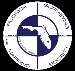
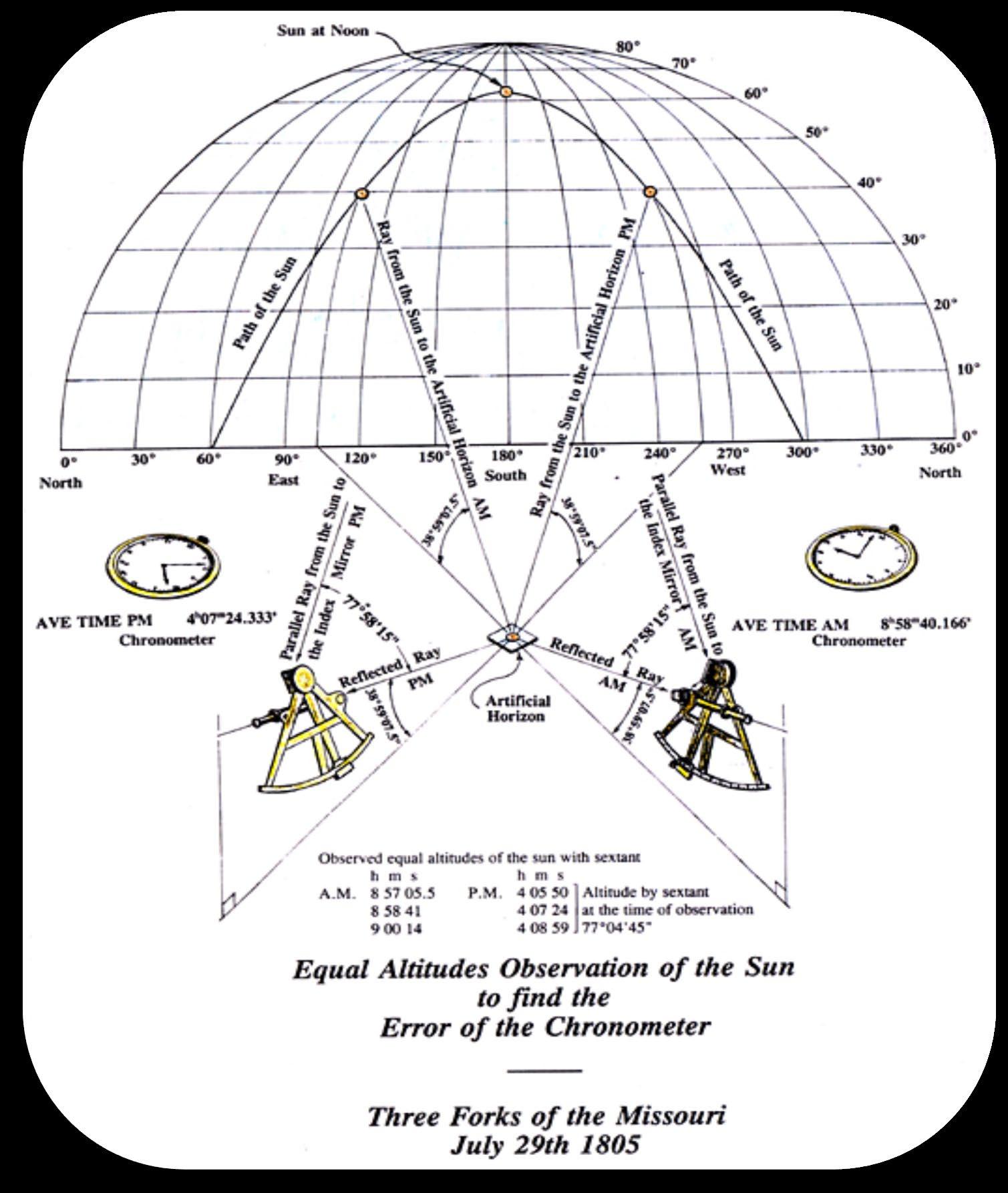
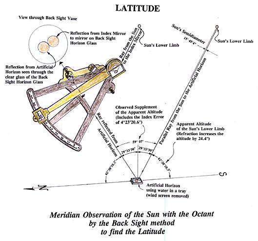
To determine the chronometer’s error on Local Time, Lewis and Clark made observations called “Equal altitudes observations of the Sun.”
Illustrations by Dr. Bergantino of the Equal Altitudes Observations of the Sun to find the error of the Chronometer.
Dr. Robert Bergantino goes into depth on several of the observations under “Deciphering the Celestial Data” on the website: https://lewis- clark.org/sciences/geography/celestial-data/. He covers nine specific stops for the celestial observations checking the calculations with comments and background on the following: The Kansas River, Fort Mandan, Marias River, Missouri Headwaters, Fortunate Camp, Clearwater Canoe Camp, Snake-Columbia Confluence, Station Camp, and Long Camp.
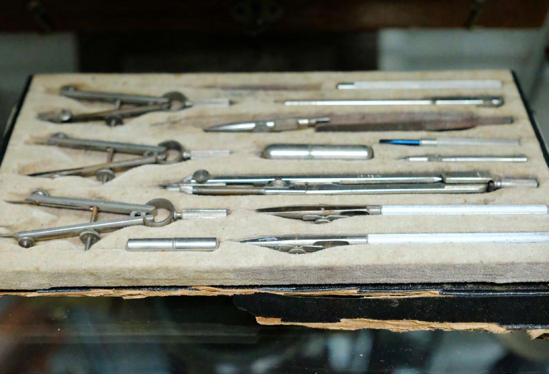
Mathematical, Scientific, & Survey Instruments for the Journey
Thomas Jefferson was eminently suited to plan such a project, for he was better informed on national geography than anyone else in the United States. He was most knowledgeable about scientific practices and instruments and was experienced in surveying, mapping, and making astronomical observations, all of which would be required to record the regions to be explored. His status as President of the American Philosophical Society put him in a unique position to call upon the nation's most prominent and influential men of science for advice and assistance in all aspects of the proposed expedition. He had many conversations in private as well as coded secret messages, which he used throughout his career, amongst his closest friends and confidents on the mission he envisioned.
Jefferson made his own instruments and scientific library available to Lewis and personally instructed him in the use of the instruments required for surveying and determining latitude. Lewis practiced particularly with the Octant; an instrument designed primarily for use at sea but used also on land to observe altitudes of the sun or a star for determining latitude. Triangular in shape, the instrument was made of a closely grained tropical wood, the limbs blackened to eliminate glare. Ebony was preferred and most often used because it was already black. A movable arm or index pivoted from the apex. About 1750, brass replaced wood for the index arm. Two sets of colored glass shades were provided for use with the sun, and a sight (or later, a telescope) was attached to the right limb. Early octants had a second sight on the opposite limb, to be used when the horizon below the sun was poorly defined and the opposite horizon had to be used. A mirror fixed to the apex moved with the arm. A glass, half mirrored and half clear, was situated on the left limb, opposite the sight.
To use the octant, the observer sighted through the peep sight to see simultaneously the horizon visible through the unsilvered portion of the horizon glass and the object, the sun or a star reflected by a mirror at the apex of the index arm to the silvered portion of the horizon glass and then to the observer's eye. When sun or star and horizon coincided in the glass, the angle between the two mirrors was one-half the altitude of the object being observed. The angle through which the index mirror moved from a parallel position was determined by the movement of the index arm: double this angle was read on the arc, which was calibrated to ninety degrees
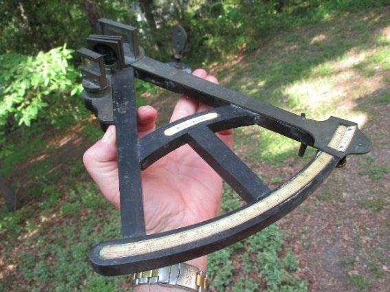
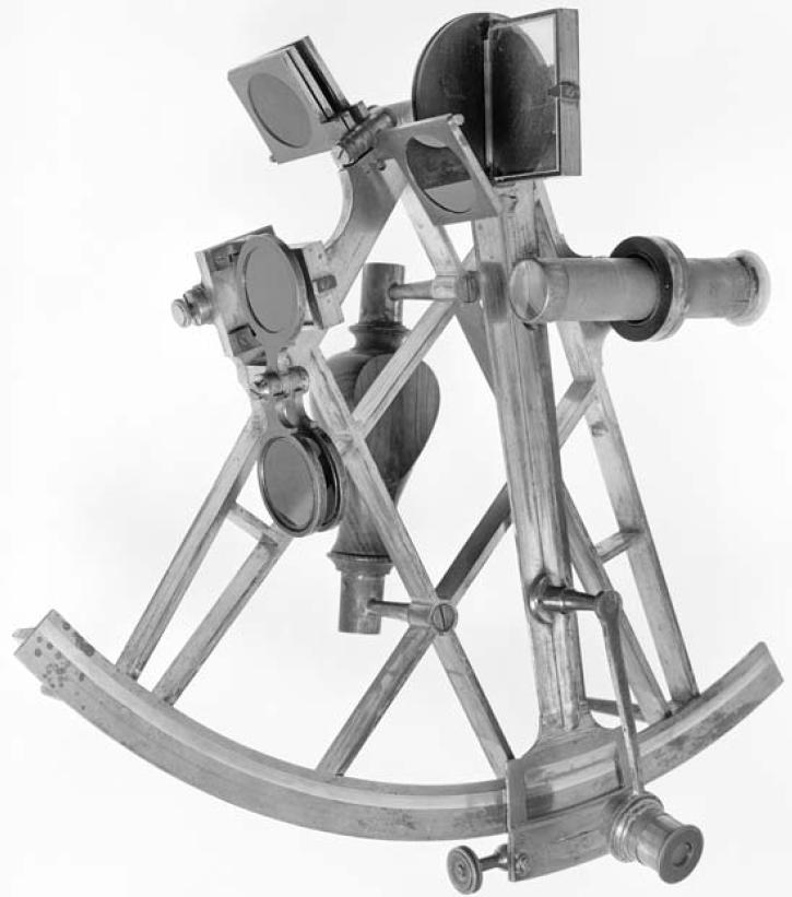
Hadley’s Quadrant Or Octant
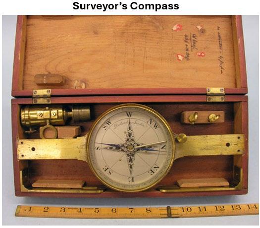
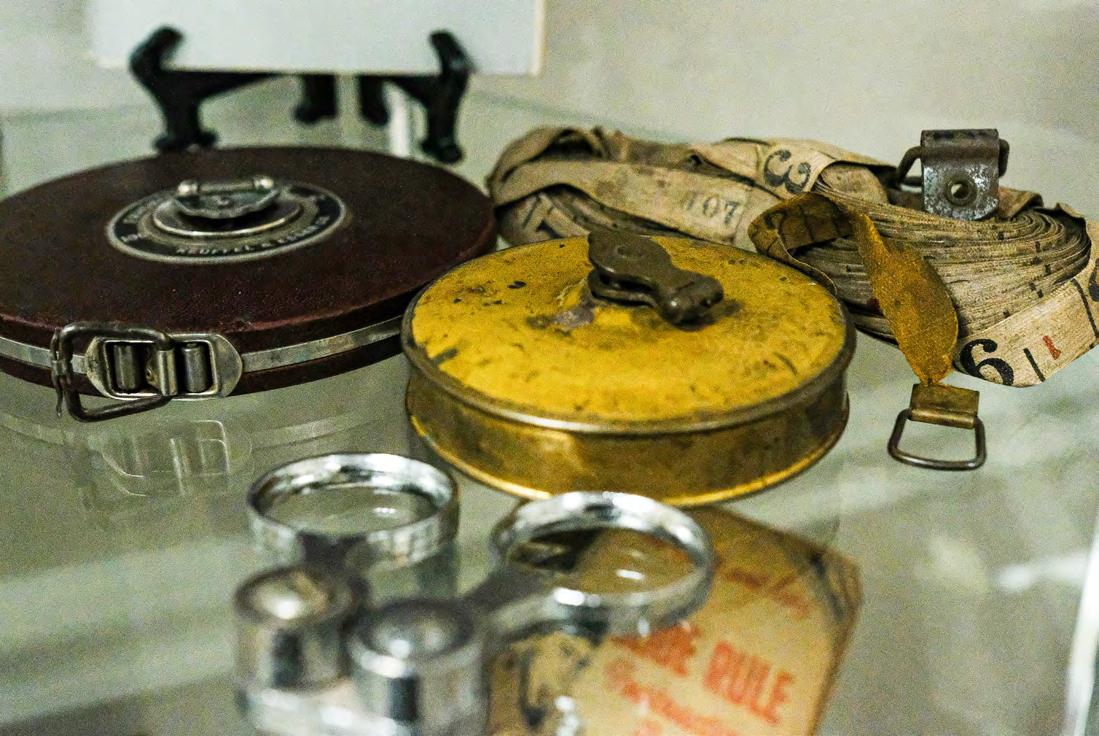
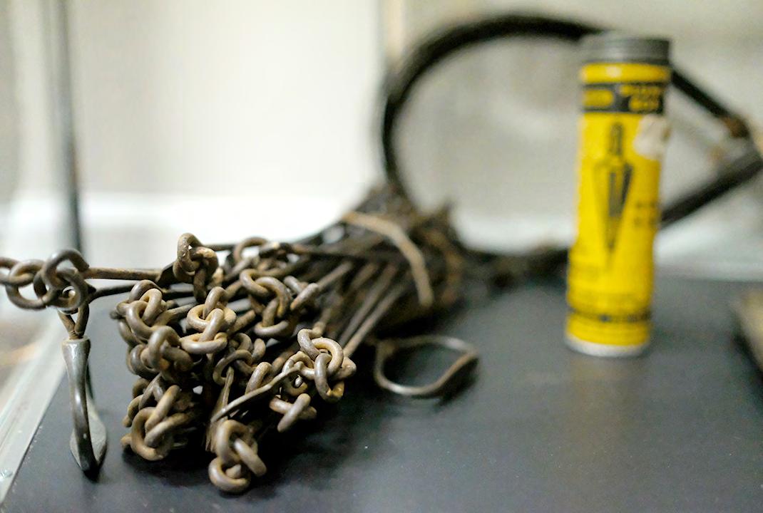
Much of what Lewis and Clark had to do in terms of their own mapmaking was to ascertain the accuracy of Indian information by doing what we call today “ground truthing” checking Indian data against their own visual observations and “celestial reckoning,” using the instruments they carried for the purpose of fulfilling Jefferson’s instructions to “take [careful] observations of latitude & longitude.” To fulfill these tasks, they used instruments: spirit and telescopic levels, several compasses including a Surveyor’s Compass or Circumferentor with extra needles and even a magnet to “polarize” them, a sextant, a “Hadley’s quadrant” or Octant, rods and chains, telescopes, artificial horizons, some drafting instruments, a very early version of a measuring tape, and a clock or chronometer. They also used books and tables giving the daily locations of sun, moon, and planets for use in computing geographical position after obtaining sightings of these “celestial objects.” The two most important groups of items of the Lewis and Clark Expedition, if cost is the measure, were mapping instruments and gifts for native people: these were the tools of empire, necessary in establishing a claim to place and space and defending that claim through trade.
In order to ensure Lewis’s education Jefferson secured the most prominent people of that time to assist in this matter. In a letter to Jefferson on 6 March 1803, Andrew Ellicott agreed to train Lewis. For the Expedition, he recommended an Arnold chronometer, three artificial horizons and methodologies for determining accurate latitude and longitude, noting that the calculations should be made after the return of the Expedition.[4] Ellicott and Jefferson arranged for the construction of a sextant and portable horizon to be made with Ellicott’s supervision. On 20 April 1803, Lewis wrote Jefferson from Lancaster that he had begun taking observations with Ellicott’s guidance. Lewis described Ellicott as “extremely friendly and attentive, . . . and is disposed to render me every aid in his power”
By May 1803, both Ellicott and Robert Patterson had become convinced that a sextant would be more accurate in obtaining longitude than the more fragile theodolite. They recommended that Lewis secure two sextants, two artificial horizons, one good Arnold’s chronometer, and at least one surveyor’s compass (with a ball and socket), a two-pole chain and one set of plotting instruments.
Both Lewis and Clark were reasonably proficient in the use of these instruments and for 28 months, as long as the Expedition was on the move, a part of the daily routine was the measurement of latitude and longitude and the calculation of course, time, and distance of travel. Even during those times when Lewis and Clark were fixed in location for lengthy periods of time, such as at Fort Mandan and Fort Clatsop, the “mathematical instruments” saw almost daily use, weather permitting.
In this, the captains followed Jefferson’s geographic directives to the letter and throughout the Expedition made the two basic types of geographical observations their sponsor had requested: (1) daily measurements of local features, taken continually during a day’s travel; and (2) the more abstract measurements of latitude and longitudinal position, usually made by astronomical observation when and where atmospheric conditions allowed, but most commonly at camp during the night. Their guides were the moon and the stars.
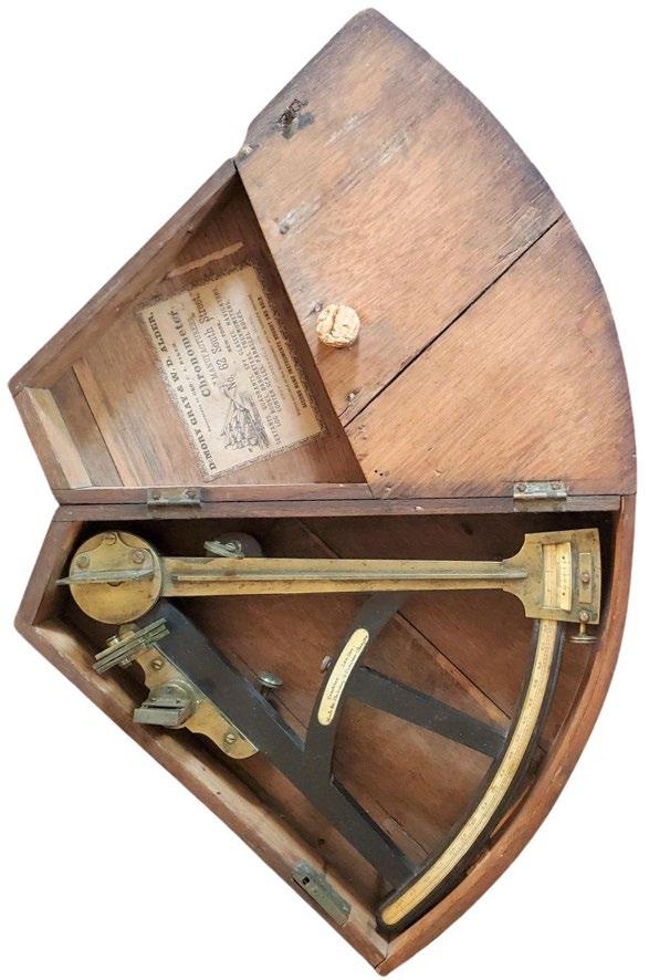
Chronometer / Clock
“...her balance-wheel and escapement were on the most improved construction. She rested on her back, in a small case prepared for her, suspended by a universal joint, she was carefully wound up every day at twelve o’clock.” (Lewis, July 22, 1804)
Image of one Lewis’s three Chronometers
Time, stated in hours and minutes, was the time required to get from the reference point used to establish the beginning of a course azimuth to the reference point marking the end of that particular compass bearing. Time was established precisely by chronometer as long as the captains remembered to keep it wound. Because they did forget to wind it regularly there were frequent occasions when travel time was an estimate. But living as close as they did to the natural world, while still having a temporal frame of reference that included hours and minutes and seconds, reasonably accurate time estimates would have been less of a problem for them than for the native peoples who possessed few or no short-term time concepts, or for us latter-day folks who are not only more divorced from nature but have relied for so long on the watches strapped to our wrists that we find it difficult to evaluate time any other way. Still, most of the temporal observations of Lewis and Clark were obtained by timepiece—the chronometer that cost more than all the rest of their “mathematical instruments” combined.
From the standpoint of navigation, the chronometer was one of the most important inventions of the 18th century. While this instrument looks a little elaborate for rough fieldwork, it performed well as long as it was kept wound. Note that the dial is calibrated in 12-hour increments rather than the 24-hour Greenwich Mean Time system used today for locational calculations. Much of modern naval terminology stems from the earliest nautical uses of the chronometer. The ship’s bell, by which time was noted, was struck at specific intervals (“eight bells” denoted the passage of four hours), a level of accuracy not possible prior to the chronometer. And “watches,” or the positions of responsibility for maintaining the ship’s course during four-hour intervals, were also regulated by the new device.
Distances
Distance was expressed between the same two points used to derive course and time. This was normally given in miles but occasionally in yards or rods. These measurements were obtained either by pacing a course between two points or by estimating distances. Estimations are relatively easy for people having long familiarity with their environment, their own travel paces and their mode of transport. Their sense of time and distance was more precise than ours because their survival so often depended on it and because they moved across the landscape in very different ways than we do. Throughout the expedition, the captains were reasonably accurate in their measurement of distance. They accomplished this with good guesswork, enlisted men to do the grunt work of pacing out courses, fairly sophisticated instruments and mathematical calculations, and careful attention to detail.
The instruments used for Celestial Observations
On 22 July 1804, while at White Catfish Camp on the Missouri River, ten miles above the mouth of the Platte, Lewis took time to enter into his journal brief descriptions of the instruments he and Clark used in making celestial observations:
1st a brass Sextant of 10 Inches radius, graduated to 15′ which by the assistance of the nonius was divisible to 15″; and half of this sum by means of the micrometer could readily be distinguished, therefore 7.5″ of an angle was perceptible with this instrument; she was also furnished with three eye-pieces, consisting of a hollow tube and two telescopes one of which last reversed the images of observe ed objects. finding on experiment that the reversing telescope when employed as the eye-piece gave me a more full and perfect image than either of the others, I have most generally employed it in all the observations made with this instrument; when thus prepared I found from a series of observations that the quantity of her index error was 8′ 45″ ; this sum is therefore considered as the standing error of the instrument unless otherwise expressly mentioned. the altitudes of all objects, observed as well with this instrument as with the Octant were by means of a reflecting surface; and those stated to have been taken with the sextant are the degrees, minutes, &c shewn by the graduated limb of the instrument at the time of observation and are of course the double altitudes of the objects observed, Meriwether Lewis”
2nd A common Octant (see previous image on page 11) of 14 Inches radius, graduated to 20′ which by means of the nonius was divisible to 1′, half of this sum, or 30″ was perceptible by means of a micrometer. this instrument was prepared for both the fore and back observation; her error in the fore observation is 2°+, & in the back observation 2° 11′ 40.3″+ at the time of our departure from the River Dubois until the present moment, the sun’s altitude at noon has been too great to be reached with my sextant, for this purpose I have therefore employed the Octant by the back observation. the degrees ‘ & ” [minutes and seconds], recorded for the sun’s altitude by the back observation express only the angle given by the graduated limb of the instrument at the time of observation, and are the complement of the double Altitude of the sun’s observed limb; if therefore the angle recorded be taken from 180° the remainder will be the double altitude of the observed object, or that which would be given by the fore observation with a reflecting surface. Meriwether Lewis”
Sketch of Captain William Clark by permission of Michael Haynes: https://www.mhaynesart.com/
Artificial Horizons
Tools for making celestial observations
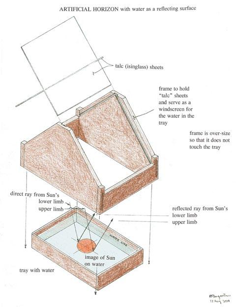
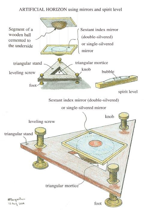
Navigators at sea could determine the altitude of a celestial body by measuring the angle between it and the true horizon. Inland away from the sea or a large body of water, however, there rarely is a true horizon. Therefore, on land, it generally is necessary to use an artificial horizon. Lewis and Clark carried three different types of them. Each design had its own advantages depending upon observing conditions. On bright days when the temperature was above freezing and the sun was being observed, Lewis and Clark commonly used a tray filled with water as an artificial horizon; the water made a level reflecting surface. When the temperature was below freezing, the captains used artificial horizons made from leveled mirrors. They also used them when observing stars because the image reflected from the mirrors was more distinct than from water. Robert Patterson, a Philadelphia mathematician and astronomer, had devised several types of artificial horizons using either a regular (single-coated) mirror or the double-coated index mirror from a sextant. The mirror was cemented onto a wooden ball, and the ball was set in a wooden frame and adjusted by three screws used as legs. It was leveled with the aid of a spirit level.
Illustrations below are from Bob Bergantino, Montana Bureau of Mining and Geology.
Type 1: Water Horizon
3rd “A summary description of the apparatus employed in the following observations: containing also some remarks on the manner in which they have been employed, and the method observed in recording the observations made with them. — Meriwether Lewis”
On 22 July 1804, while at White Catfish Camp on the Missouri River, ten miles above the mouth of the Platte, Lewis devoted most of journal entry to a description of each of the instruments he and Clark used in making celestial observations. An Artificial Horizon on the construction recommended and practiced by Mr. Andrew Ellicott of Lancaster, Pennsylvania, in which water is used as the reflecting surface; believing this artificial Horizon liable to less error than any other in my possession, I have uniformly used it when the object observed was sufficiently bright to reflect a distinct image; but as much light is lost by reflection from water I found it inconvenient in most cases to take the altitude of the moon with this horizon, and that of a star impracticable with any degree of accuracy.
Type 2: Mirror Horizons
In his journal for 22 July 1804, Lewis described the second type of artificial horizon as follows:
4th An Artificial Horizon constructed in the manner recommended by Mr. Patterson of Philadelphia; glass is here used as the reflecting surface, this horizon consists of a glass plane with a single reflecting surface, cemented to the flat side of the larger segment of a wooden ball; adjusted by means of a spirit-level and a triangular stand with a triangular mortice cut through its center sufficiently large to admit of the wooden ball partially; the stand rests on three screws inserted near it’s angles, which serve as feet for it to rest on while they assist also in the adjustment. This horizon I have employed in taking the altitude of the sun when his image he has been rather too dull for a perfect reflection from water; I have used it generally in taking the altitude of the moon, and in some cases of the stars also; it gives the moon’s image very perfectly, and when carefully adjusted I consider it as liable to but little error. Meriwether Lewis”
Type 3:
Lewis described was similar to the second
5th An Artificial Horizon formed of the index specula [mirror] of a Sextant cemented to a flat board; adjusted by means of a spirit level and the triangular stand before described as this glass reflects from both surfaces it gives the images of all objects much more bright than either of the other horizons; I have therefore most generally employed it in observing the altitudes of stars Meriwether Lewis”
Celestial Reckoning
. . . you will take [careful] observations of latitude & longitude Thomas Jefferson, Instructions to Meriwether Lewis, 20 June 1803.
The following is from the Montana Bureau of Mining and Geology
Thomas Jefferson envisioned the Lewis and Clark Expedition as a scientific expedition but also hoped it would find a practical commercial route to the Pacific. Not only did Jefferson want the scientific information that expedition obtained, but he also wanted an accurate map of the country through which it passed. To make an accurate map of such a large area would require accurate locations of river junctions, rapids, falls, mountain passes, and native settlements. Jefferson knew that such a map could not be made from a survey using just a magnetic compass and estimated distances. The solution: find the latitude and longitude of important points along the route and adjust the compass survey to them.
Latitude is the angular distance north or south of the equator. The latitude at the equator is 0°; at the poles it is 90°.
Illustration from Robert Bergantino of Lewis’s method of meridian observation for Latitude at Camp Fortunate on August 18, 1805 his 35th birthday.
Longitude is the angular distance east or west of the Prime Meridian (the north–south line through Greenwich, England); the longitude there is 0°. From the Prime Meridian the longitude increases eastward (east longitude) to 180° and also westward (west longitude) to 180°. The intersection of a parallel of latitude with a meridian line of longitude marks the location of a unique spot on the surface of the earth.
In the early 19th Century, latitude and longitude usually were determined from celestial observations taken with a sextant or octant and chronometer. Lewis purchased this equipment in 1803. He also received training in how to make celestial observations and calculate them. From this training Lewis taught William Clark. Clark already knew how to use a magnetic compass to survey, and he had a talent for map drawing. The expedition’s route survey would be made with a magnetic compass. The captains, therefore, also needed to make observations to determine how many degrees the compass needle pointed away from true north (that is, the magnetic declination). The celestial observations the captains took would fi x the latitude and longitude of important geographic points and, by knowing the magnetic declination, the survey made with the magnetic compass between those points could be corrected to true north. From this, a cartographer could produce an accurate map.
The captains’ celestial observations yielded nothing more than raw data. To determine latitude, longitude and magnetic declination, etc., their observations were processed with information provided by almanacs and tables.
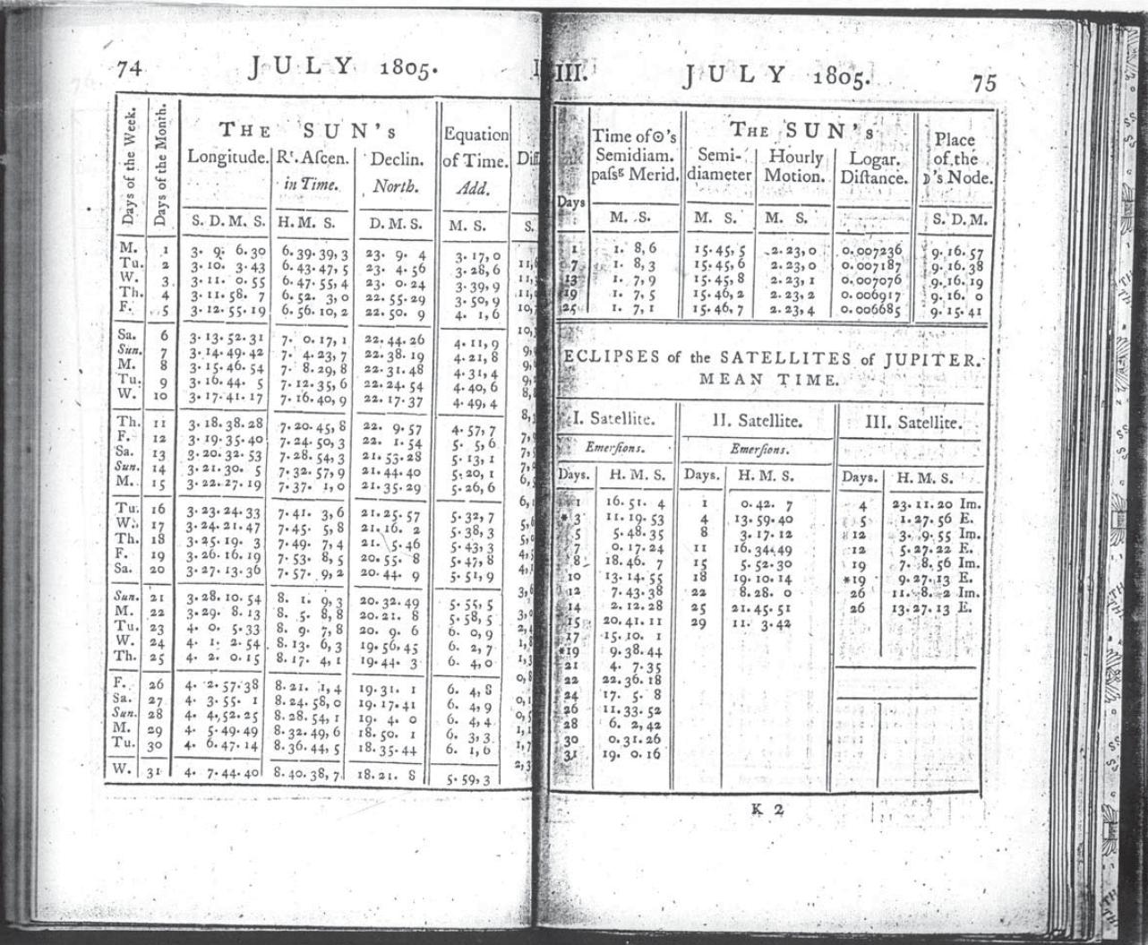
Lewis carried The Nautical Almanac and Astronomical Ephemeris for the years 1803, 1804 and 1805 (it is not certain that he had the 1806 almanac). The almanacs were published several years in advance of the year indicated on them and gave the celestial coordinates of the sun, moon, planets, and navigational stars at various increments of time at Greenwich, England.
A companion book to the Nautical Almanac was Tables Requisite to be Used with the Nautical Ephemeris for Finding the Latitude and Longitude at Sea (Nevil Maskelyne). These books provided Lewis and Clark with valuable information on how and when to take observations, what corrections they needed to make to obtain valid results, and how to calculate geographic data from most of their observations. In addition, Lewis brought along a copy of A Practical Introduction to Spherics and Nautical Astronomy (Patrick Kelly), a practical guide to spherical trigonometry and how to compute celestial observations and convert them into geographic information.
The Astronomy Notebook – By Robert Patterson for Meriwether Lewis https://lewis-clark.org/sciences/geography/celestial- data/astronomy-notebook/ https://digital.shsmo.org/digital/collection/frontier/id/169
Known now as the “Astronomy Notebook” this extraordinary document has been an obscure and often neglected detail in the history of the Lewis and Clark Expedition. Yet there are few other pre- expeditionary documents that are equal to it in importance, for it contains the keys to the fulfillment of Jefferson’s primary charge to Lewis: “Beginning at the mouth of the Missouri, you will take observations of latitude & longitude, at all remarkable points on the river, & especially at the mouths of rivers, at rapids, at islands, & other places . . . as that they may with certainty be recognized hereafter. . . . The variations of the compass too, in different places, should be noticed.” All those observations were to be taken, he emphasized, “with great pains & accuracy,” and ultimately submitted to the Secretary of War, who would have the calculations completed “by proper persons.”
Astronomy Book Cover:
Although no author’s name appears on the document, it was clearly the work of Robert Patterson of Philadelphia, Pennsylvania. His authorship is easily traced through reference to a letter that Patterson wrote to Thomas Jefferson on 15 March 1803, in which Patterson detailed his method for computing longitude from an observation
for Lunar Distance. The formulation stated there is essentially identical to that expressed in Problem 5 of the Notebook. But there is additional confirmation of the authorship . . .
Robert Pattersons Astronomy book set out examples of problems that Captain Meriwether may run across in language he thought would be easy to understand. Examples are shown below:
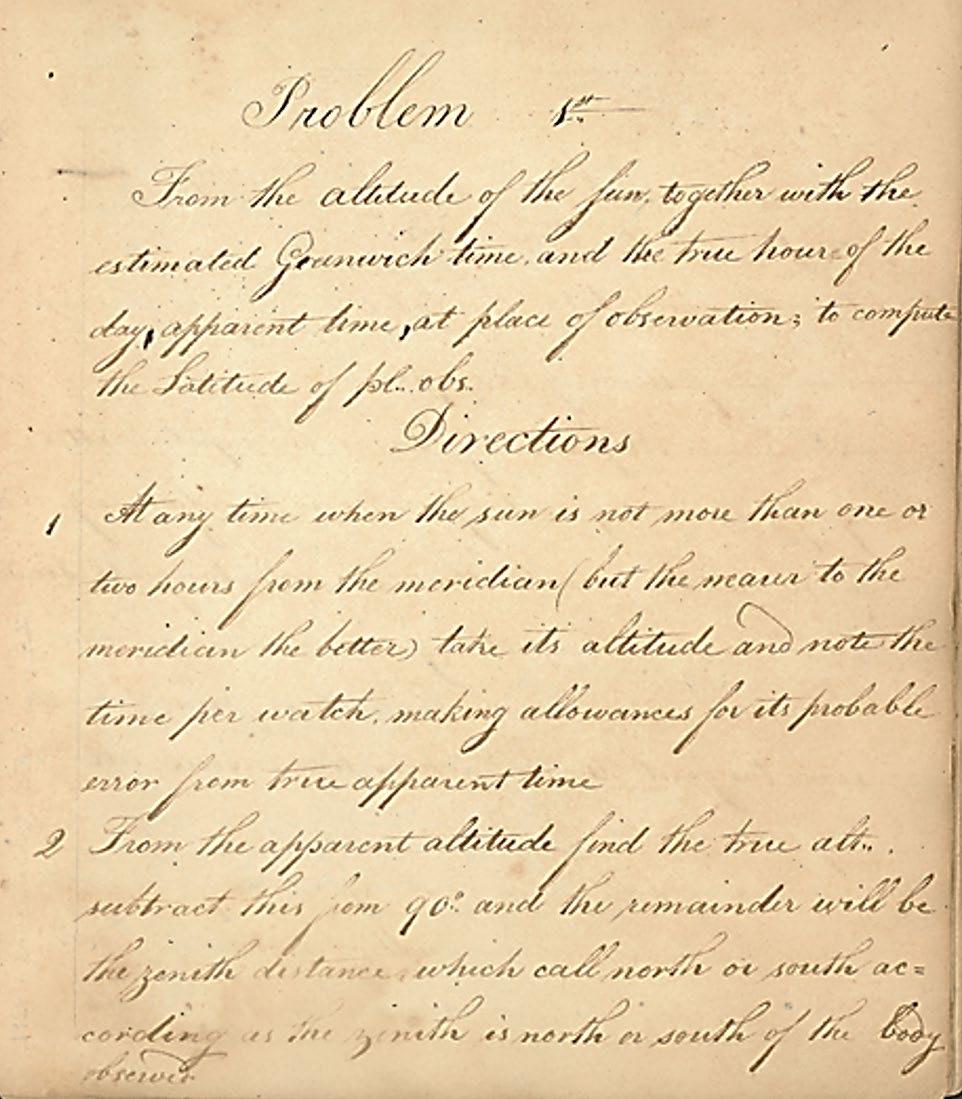
Transcript of Problem 1 from the Astronomy Notebook - prepared for Captain Meriwether Lewis by Robert Patterson, Philadelphia, Pennsylvania, 1803
https://digital.shsmo.org/digital/collection/frontier/id/139 State Historical Society of Missouri
Problem 1 - Latitude
From the altitude of the sun, together with the estimated Greenwich time, and the true hour of the day, apparent time, at place of observation; to compute the latitude of [the] place [of] observation.
Directions
At any time when the sun is not more than one or two hours from the meridian, but the nearer to the meridian the better, take its altitude and note the time per watch, making allowance for its probable error from true apparent time.
From the apparent altitude find the true altitude, subtract this from 90° and the remainder will be the zenith distance which call north or south according as the zenith is north or south of the body observed.
• Find the true declination of the sun for the estimated Greenwich time.
• From the time at place observation find the hour angle of the sun at the time of observation.
• From the above data the latitude may be computed
Example 1
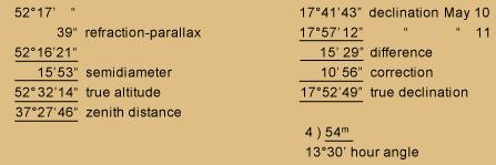
Suppose the apparent altitude of the sun’s lower limb above the southern horizon = 52°17′, Estimated Greenwich time May 10th, 1799, about 17 hours p.m., True apparent time at place of observation = 54m p.m. Required the latitude.
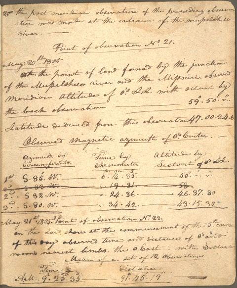
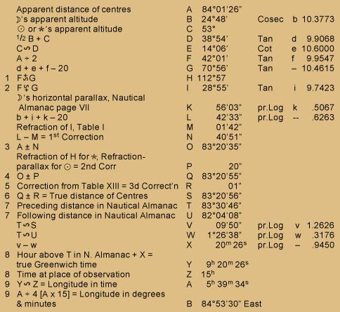
Lewis must have made a copy of the statistical table for his field use on his trip. Following this table there are two pages, also in Lewis’s hand, explaining his procedures for taking and recording astronomical observations together with an entry from Point of Observation No. 21 at the mouth of the Musselshell River (20 May 1805) See image below showing how he used the formulas.
Patterson writes: June 18th, 1803.
Sir:
I recommended to Capt. Lewis the use of a Statistical Table in which to set down his astronomical observations, in the course of his intended expedition; as an expedient that would save a great deal of time and be productive of many other obvious advantages. I had proposed to draw him out a sketch of such a table, but an unusual hurry of business prevented me, while he was in the city. I have now, however, fulfilled my promise and transmit the enclosed for his inspection.
I have sent it under cover to you, Sir, lest Capt. Lewis may have proceeded on his tour; in which case, if you shall judge it worth his notice, you will have trouble forwarding it to him.
I am Sir with the highest respect & esteem, your Obedient Servant. R. Patterson
Following Patterson’s statistical document Lewis dutifully collects the information that Patterson recommends and places it in an organized fashion in the Astronomy Book.
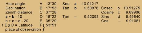
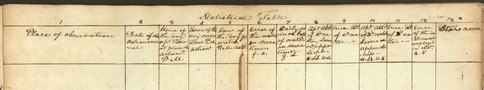
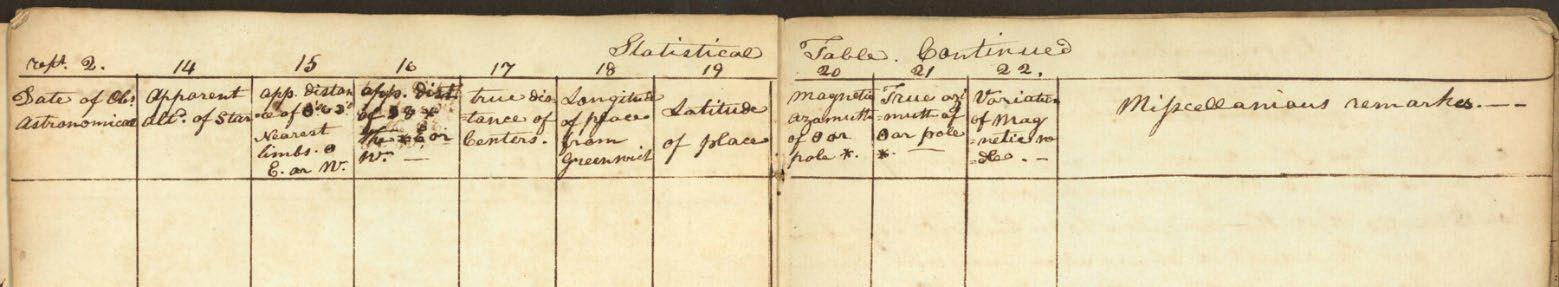
in Lewis’s own handwriting, the Statistical Tables below, shows those recommended values by Patterson set out in his letter to Jefferson of June 18, 1803. The columns extend across four double pages (13¼ in. x 7½ in.). There are no entries on this list, just the headings in each of the columns.
A breakdown of the numbering above each column is below the images on the next page.
The Statistical Table numbered fields below relate from Patterson’s document to Lewis’s list above:
1. Place of observation
2. Date of observation Astronomical
3. Hour of the Day apt. Time at place observed Astronomical P.M.
4. Hour of the day mean Time P.M. astronomical
5. Hour of the day pr. watch. P.M. astronomical
6. Error of the watch on mean time f. s.
7. Daily gain or loss of watch on meantime. g. s.
8. Apt. altitude of ⊙’s center, lower or upper limb ⊙. LL. UL.
9. true altitude of ⊙’s center
10. Apt. altitude. of ⋑’s center Lower or upper li-mb ⊖. LL. UL.
11. true altitude. ⋑’s center
12.Error of the instrument employed in observation. B. F.
13.Star’s name
Repeat No 2. Date of observation Astronomical
14.Apparent altitude of Star
15.approximate distance ⊙’s & ⋑’s Nearest limbs. ⊙ E. or W.
16.approximate distance of ⋑ & * The * E. or W.
17. true distance of Centers.
18. Longitude of place from Greenwich
19. Latitude of place
20. Magnetic azimuth of ⊙ or pole *.
21. True azimuth of ⊙ or pole *.
22.Variation of Magnetic needle.23. Miscellaneous remarks.
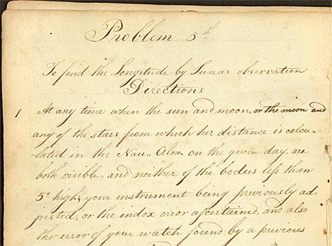
Problem 5 - Longitude
The Astronomy Notebook - Page 18
Western Historical Manuscript Collection, Columbia, Missouri. Light Touch
Lewis must have smiled at Patterson’s whimsical embellishments of an astronomer’s shorthand moon symbol. To find the Longitude by Lunar observation
Directions
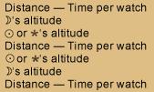
1. At any time when the sun and moon, or the moon and any of the stars from which her distance is calculated in the Nautical Almanac on the given day, are both visible, and neither of the bodies less than 5° high; your instrument being previously adjusted, or the index error ascertained, and also the error of your watch found by a previous observation as directed [in] problem 3d, take a set of three or more observations of the apparent angular distance of the sun and moon’s nearest limbs, or of the star from the moon’s nearest or farthest limb, viz. that which is fully enlightened, noting the corresponding times per watch; and at the time that you measure the distance, let two [Page 19:] assistants take the altitudes of the bodies, respectively. Or the distances and the altitudes may all be taken by the same observer, at small equal intervals of time in the following order, viz.,
Distance — Time per watch
Moon’s altitude
Sun or Star’s altitude
Distance — Time per watch
Sun or Star’s altitude
Moon’s altitude
Distance — Time per watch
2 Of these distances, times and altitudes, take means by dividing their respective sums by the number of observations.
3. Let the mean altitudes be so far corrected as respects semidiameter, so as to obtain the apparent altitudes of the centers above the true horizon.
4. To the apparent distance of sun and moon’s nearest limbs add the sun’s semidiameter, Nautical Almanac page III, [Page 20:] of the month, and also the moon’s semidiameter, Nautical Almanac page VII of the month, increased by the augmentation, Table IV. When the distance of a star from the moon’s nearest limb is observed, you must add the moon’s semidiameter + augmentation; but when the star’s distance from the moon[‘s] farthest limb is observed, you must subtract the semidiameter + augmentation; and thus, you will have the apparent distance of the centers of the bodies observed.
5. If at the time of taking the above observations, one of the bodies (but especially the sun) be not less than 3 or 4 points of the compass [33¾°- 45°] from the meridian, the time at place observation may be computed
from the altitude of the body, as in Problem III independently of the time per watch, and this should always be done when circumstances admit.
6. As it may frequently happen that the altitudes [Page 21:] of one or both of the bodies cannot well be taken you must then compute the apparent altitudes by problem 4th, and this method is generally to be preferred on land.
From the above data, the longitude of place observation may be computed as in the following example
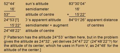
Example
Suppose the apparent angular distance of the sun and the moon’s nearest limbs (by taking the mean of a set of observations) to be 83°30’04”. The apparent altitude of the sun’s lower limb measuring 52°44′ and that of the moon’s lower limb 24°32′, Greenwich time September 22, 1799, about 9 hours
p.m. Time at place observation (allowing for error of watch from true apparent solar time) 15 hours p.m.
Required the longitude of place observation from the meridian of Greenwich?
Everyone makes mistakes
[* Patterson has the altitude 24°53′ written here, but in the problem, gives the altitude as 24°32′, yet derives 24°47’22” (24°48’22”?) for the altitude of its center, which he uses in Form V, as 24°48′ for the altitude of the center.
Below is a note from Dr. Robert Bergantino at Montana Bureau of Mining and Geology from the website https://lewis- clark.org that I think sums up what Captain Lewis was up against and yet completed despite all of the odds against him and Captain Clark. An amazing accomplishment and a tribute to them and to President Jefferson for the dreams he had and pushed forward into reality.
Note: Despite Patterson’s assurance to Thomas Jefferson that his astronomical formulas would be “extremely easy even to boys or common sailors of but moderate capacities,” it will soon be obvious that only readers with a working knowledge of trigonometry will find Patterson’s didactic little notebook comprehensible, or even interesting. But then, Lewis evidently had had little or no exposure to higher math prior to his crash courses with the astronomer and surveyor Andrew Ellicott in Lancaster and with Robert Patterson in Philadelphia in a time span of no more than a few weeks that was crowded with a myriad of other pre- expedition details and obligations. However, anyone should be able to appreciate what a challenge Lewis faced in trying to comprehend these concepts and learning to use them. Indeed, the sheer weight of it should inspire even greater admiration for this young officer for his fortitude in taking on this challenge along with everything else. ……….
Robert N. Bergantino, July 2005
This was not just survey and map of a trading route with the Native Americans between St. Louis and the Pacific Ocean but a scientific journey of discovery of everything there was to know of that wilderness, the waters, the people and their customs, the Flora and Fauna, the soils, the minerals, the fossils, the mountains, and any volcanic areas. But Surveying and Mapping it as accurately as possible was a critical step in being able to understand it and control it in the future. The first two maps in this article show how little was known of the area before the expedition.
Captain Lewis, even though he was the official leader of this group, he had told Captain Clark from the beginning that they would share control equally and he kept his word throughout the journey. Captain Clark’s Map making abilities and math skills were superior to Lewis and on several occasions Clark would check Lewis’s celestial observations and Lewis would correct his notes. They had a wonderful relationship and respected each other’s abilities. The entire trip from St. Louis and back started on May 14, 1804, and returned on September 24, 1806
Captain Lewis’s response to his accomplishments at a party in his honor at a farm in Albemarle County Virginia on December 13th, 1806: “With you I trust, that the discoveries we have made, will not long remain unimproved; and that the same sentiment which dictated to our government, an investigation into the resources so liberally bestowed by nature in this fair portion of the globe, will prompt them to avail themselves of those resources, to promote the cause of liberty and the honor of America, and then to relieve distressed humanity, in whatever shape she may present herself .”
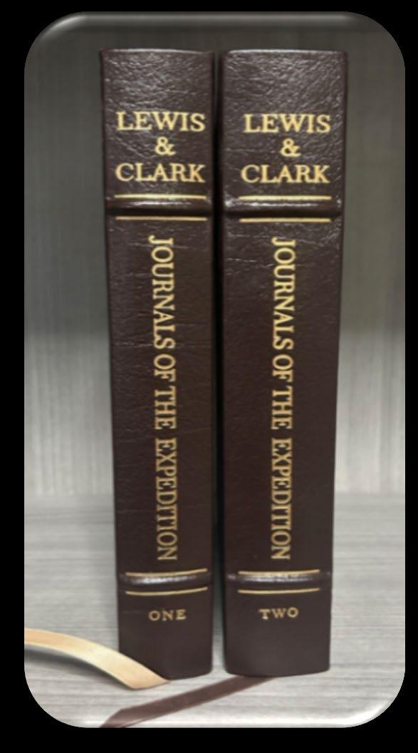
Part 2 concludes my article for Surveyors & Mappers on the Lewis and Clark Expedition and their contribution to mapping the western part of the US. What started for me on this journey was reading The Eston Press’s Collector’s Edition of “The Journals of the Expedition under the Command of Capt.’s. Lewis and Clark”, volumes one and two, edited by Nicolas Biddle, copyright 1962.
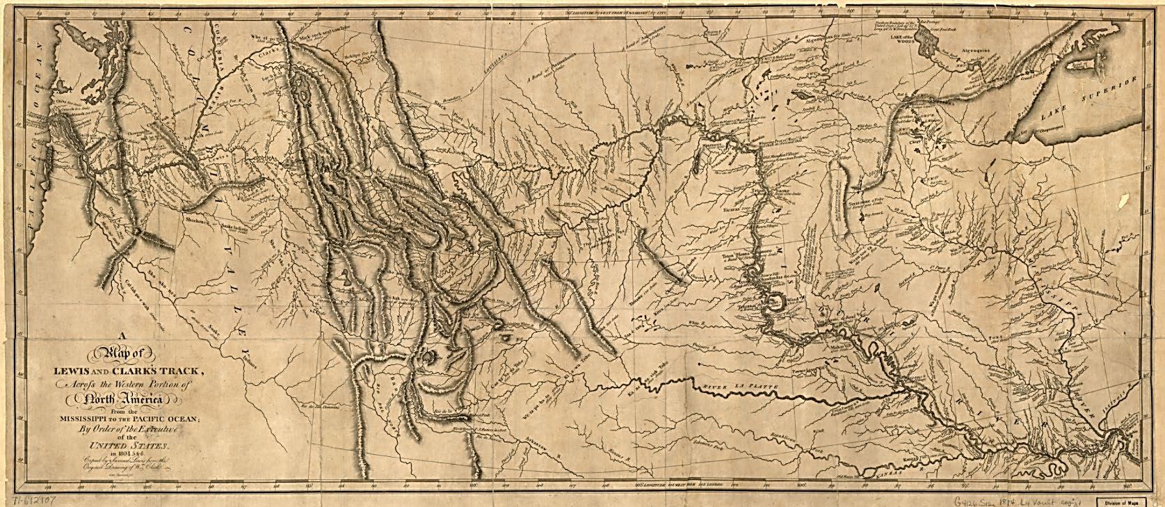
Once I finished reading the journals, my research for this article took me so much further down the rabbit hole of this expedition that it was difficult to stop reading because of the massive amount of information that has been collected on this adventure, which most Surveyors have probably never read. Hopefully this will set you on a journey of your own to discover the Story behind the Final map below, and the adventure of a lifetime from the “Corps of Discovery” Lewis & Clark’s Expedition.
This exquisite map is beautiful and awe inspiring and in order to get the full effect I encourage you to download it by the link I give from the U.S. Library of Congress. Always look beyond what you see to find the hidden treasures of our history and share them.
- Richard D. Pryce, RLS/PSM
Map from Library of Congress: A map of Lewis and Clark's track, across the western portion of North America from the Mississippi to the Pacific Ocean : by order of the executive of the United States in 1804, 5 & 6 | Library of Congress
Enlargements of map on next pages
2026 MEMBERSHIP IS OPEN!
Membership for 2026 is open and available for those needing to renew or for those wanting to join The Florida Surveying and Mapping Society. You can Renew your current membership by Clicking Here and logging-in to your FSMS account.
For those New Members wishing to join or rejoin if they were not a member in 2025, Click Here to read about our Membership types and click on the “Join FSMS Today ” button at the top of the page to begin your membership with The Florida Surveying and Mapping Society.
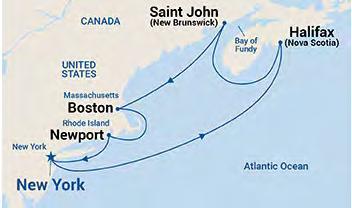
Seminars at Sea 2026 Seminars at Sea 2026
The Cruise
• Princess Cruise Line - Majestic Princess
• 7 Nights
• Leaving out of New York Harbor 10/3/26
• Newport, Rhode Island
• Boston, Massachusetts
• A morning of “Learning” at Sea
• Saint John (for the Bay of Fundy), Canada
• Halifax (Nova Scotia), Canada
• A morning of “Learning” at Sea
• Return to New York Harbor 10/10/26
The Learning
• Two - 6 hour live morning classes while onboard during two days at sea from 7 am to Noon.
• History of Swamp and Overflowed Lands and Island Surveys in Florida (6 CECs) Course# 11097
• The Great Halifax Explosion of 1917: The Roles of the Surveyors & Planners (6 CECs) Course# 11096
• 12 hours CE Credit via your choice of Correspondence Courses.
• Registering for the Learning will be at an additional cost of $500 per seminar attendee above the cost of the Cruise. Click Here to Register for The Learning Provider No. CE11.
The Instructor
Dr. Joe Knetsch will be our live onboard instructor for the 2026 Seminars at Sea. Dr. Knetsch received his Ph. D. in history from Florida State University (1990), an MA in history from Florida Atlantic University (1974) and a B.S. from Western Michigan University with a major in History and Economics. He was the historian for the Florida Department of Environmental Protection (formerly Department of Natural Resources), Division of State Lands from 1987 to August of 2014.
The Details
• Book early to secure your cabin - FSMS currently has Deluxe Mini-Suites and Deluxe Balconies on hold until May 2026 at the below rates. Click Here to Check out the Cabins and their Availability
• Category MB - Mini-Suite $2066 per person based on double occupancy.
• Category DB - Balcony $1846 per person based on double occupancy.
• Please note at the time of booking with Princess any promotions which could include reduced fares or deposits will be applied to your booking. If there is another category of cabin you would like to book, our Travel Advisor Gail Oliver will work with you on finding the best cabin for the best rate to suit your needs. It is important to book with Gail to be considered a part of the FSMS group to receive the group benefits. Contact Gail Oliver at Tesoro Travel via email at gail@tesorotravel.com or phone at 904-687-5655.
The Sponsorship
$3000
• Verbal Recognition during Event
• T-shirts with your company logo
• “Thank You” on FSMS website and social media posts
• Listed in all Seminars at Sea Communication
• Featured Full-page ad in The Florida Surveyor Magazine
NGS Multi-Year CORS Solution 3 Released
NGS has implemented the new International Terrestrial Reference Frame 2020 (ITRF2020) and IGS20 realizations in the U.S. Nation al Spatial Reference System (NSRS) in order to maintain consistency with t he International Earth Rotation and Reference System Service (IERS ) and the International GNSS Service (IGS) reference frames. This results in updated North American Datum 1983 (NAD 83) coordinat es for stations in the NOAA CORS Network (NCN), kept at epoch 2010.0. This update is called the Multi-Year CORS Solution 3 (MYCS3) and it follows NGS’s MYCS2 effort from 2018.
What's new?
This update to the NSRS has been implemented.
• New coordinate functions for NOAA CORS Network (NCN) stations consistent with ITRF2020
• Datasheets will display new NAD 83 coordinates transformed from ITRF2020 coordinate functions.
• The new NAD 83 coordinates will remain at reference epoch 2010. 0
• Position and Velocity (P&V) files will display coordinates/veloc ities in both NAD 83 and ITRF2020
• The NGS Online Positioning Users Service (OPUS) will begin proc essing data with NCN control that is consistent with ITRF2020 at the t ime of measurement; results will still be transformed to NAD83 at e poch 2010.0.
Background:
On October 2, 2022, the International Earth Rotation and Refere nce System Service (IERS) released a new realization of the Interna tional Terrestrial Reference Frame called ITRF2020 . The new frame supersedes the previous version called ITRF2014. The ITRF2020 release was followed shortly by the release of a new frame realization by the Intern ational GNSS Service (IGS) called IGS20 which is closely related to ITR F2020. Learn more in the Multi-Year CORS Solution v3 (MYCS3) webinar .
FSMS is Awarding a Recruitment Bonus for
Current Members
Bringing in New Memberships
The Bonus will be a Conference Packet One Registration (includes One Wed. BBQ Ticket, One Fri. Exhibitor's Luncheon Ticket, One Fri. Recognition Banquet Ticket, and Six Sat. Seminar CECs) along with a 2 Night Stay at JW Marriot Miami.
• The Recruitment Bonus will be Awarded based on a Point System.
• 6 Points for each New Full Member, Gov. Surveyor, & Sustaining Firm.
• 1 Point for each New Associate, Affiliate, & Student Member.
• Whenever a New Member fills out their membership form they must provide referred current member's name when asked, “Were you referred by a Current Member of FSMS?” Points will be awarded during Open Enrollment between now and March 31, 2026. The Member with the most points will be deemed the Winner and be announced in April's edition of The Florida Surveyor!
Multiple NSRS Modernization Products
Published to Beta
NGS has released the following four groups of products to the NGS beta website to solicit review and feedback from stakeholders as part of th e modernization of the National Spatial Reference System (NSRS): (Note: These products are not final and should not be used for anything other than review and testing.)
North American-Pacific Geopotential Datum of 2022 (NAPGD2022) . This datum will replace the North American Vertical Datum of 19 88 (NAVD 88) and all other vertical datums for islands in the United Sta tes. It will serve as a foundational component of the modernized National Sp atial Reference System (NSRS), providing precise definitions for ortho metric height (elevation). The release includes the defining grids that collectively make up the datum along with a number of supporting products to visualize the datum.
• Products . All NAPGD2022 products are provided as grids for the following: GEOID2022, DEFLEC2022, GRAV2022.
• Example coordinates. Coordinates and product values are computed for numerous example points throughout NAPGD2022 and provided in a table.
• NAPGD2022 Experience . Interactive online maps showing NAPGD2022 products for all regions that can be used on a computer or mobi le device to query any location.
• Maps of NAPGD2022 products . Static map images of NAPGD2022 products for all regions.
New Terrestrial Reference Frames of 2022 for North America (NATRF2022), Pacific (PATRF2022), Caribbean (CATRF2022), and Mariana (MATRF2022) plates . These four geodetic reference frames will replace the North American Datum of 1983 (NAD 83). They will se rve as a foundational component of the modernized NSRS, providing prec ise definitions for geodetic latitude, longitude, and ellipsoidal he ight.
• Euler Pole Parameters of 2022 . All of the new terrestrial reference
frames are defined by transformation from the International Terr estrial Reference Frame of 2020 (ITRF2020) using Euler Pole Parameters (EPPs) that model tectonic plate rotation.
State Plane Coordinate System of 2022 (SPCS2022) . A system of map projections for accessing the modernized NSRS. Zone designs hav e been incorporated into the following beta products and services:
• Zone information tables . SPCS2022 zone definitions, example coordinate computation results, minimum and maximum coordinate values, and minimum coordinate differences with overlapping SPCS2022 zones and with other coordinate systems, provided as interactive tables that can be sorted and filtered.
• SPCS2022 Experience . Interactive online maps showing distortion for all SPCS2022 zones that can be used on a computer or mobile dev ice to get distortion at any location or to view zone definitions.
• Maps of SPCS2022 zones and distortion . Static map images of SPCS2022 zone layers, number of zones, and distortion with performance statistics.
NGS Coordinate Conversion and Transformation Tool (NCAT) . This version can be used to perform SPCS2022 coordinate conversions at any location for all SPCS2022 zones. Later beta versions will inclu de the ability to transform between reference frames and vertical datums.
Products found on the NGS beta website are preliminary releases that are for testing and evaluation only; they are not final products nor do they contain any authoritative NGS data or tools. To provide feedbac k on any of the content on this site, please email ngs.feedback@noaa.gov .
Rollout Plan for Remaining NSRS
Modernization products, including OPUS Products Changes
On June 17, 2025, NGS released the first preliminary products of the modernized National Spatial Reference System (NSRS) for beta testing and feedback. In the coming months, additional products listed below will be made available. As each product is released, it will undergo at least six months of testing preceding the final adoption and implementatio n of the modernized NSRS.
The descriptions below supersede previous updates or informatio n shared in NSRS Modernization blueprint documents, plans, or presentations. These products and their status will be describe d on the Track Our Progress webpage .
1. The Data Delivery System (DDS) landing page will provide an updated version of the “NGS Map” and “Looking for Benchmarks” pages. Th is new landing page will allow you to access modernized informatio nal pages about geodetic stations and geodetic marks.
2. Geodetic station pages will offer an updated version of the current NOAA CORS Network (NCN) station pages. Geodetic mark pages will be updated datasheets, replacing the current ASCII text file ver sion of datasheets. The updated coordinates (reference epoch coordinate s) for marks and updated CORS coordinate functions (CCFs) for CORSs in the modernized NSRS will be available through these pages.
3. The NGS Coordinate Conversion and Transformation Tool (NCAT) will be updated through multiple versions, currently with state plane coordinates, then later adding support for various geopotential calculations including ellipsoid/orthometric height conversion as well as NADCON (geometric) and VERTCON (orthometric) transformations fr om the current NSRS to the modernized NSRS.
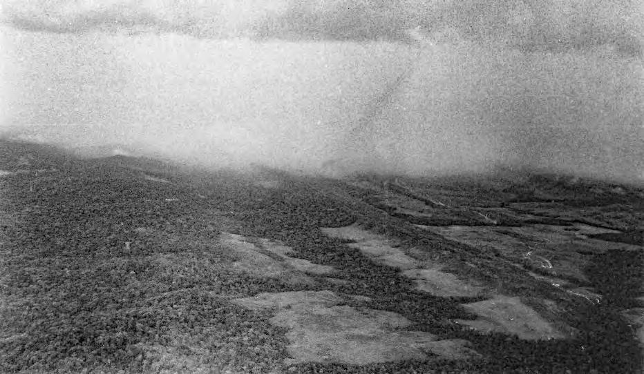
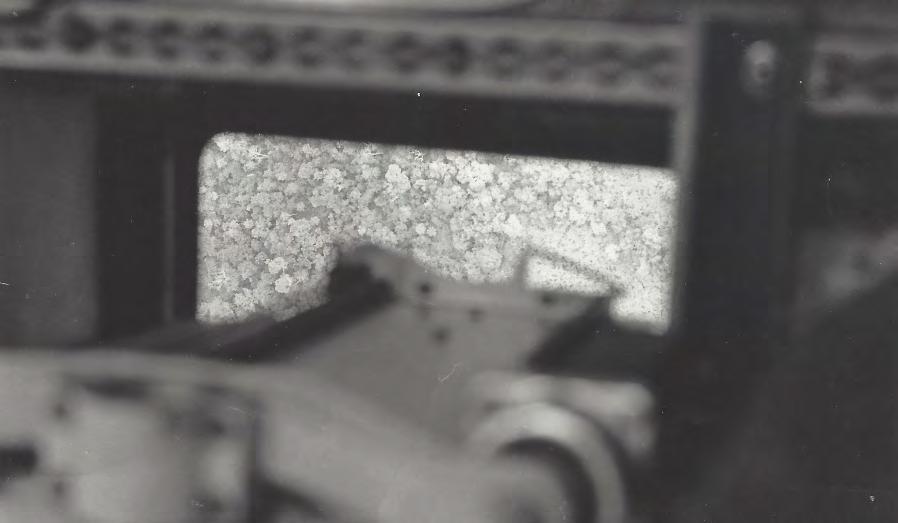
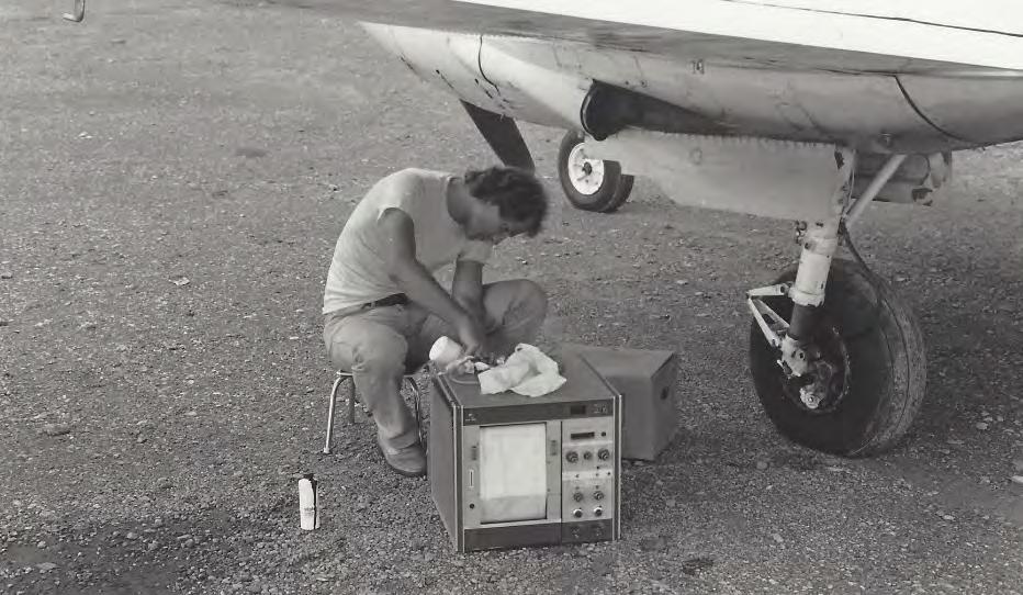
Adventures in the Amazon (Part 2)
Juan Plaza shares the untold story of the Airborne Profile Recorder (APR), the precursor to lidar.
After the excitement (and disappointment) of the flight we had to scrub was behind us, I found myself aboard a commercial airliner back to Canaima with a little brown box covered in postal stamps. It weighed about a pound and inside was the spare part to return the laser of our APR to full strength, which would hopefully allow us to fly at least at an altitude of 4,000 ft AGL (and save us from flying below those intimidating cliffs).
As soon as I deplaned, the team was waiting for me at the small terminal and we walked directly to the aircraft, parked about two hundred feet from the busy commercial section of the airport. Rudy and the pilot had already opened the case that houses the laser—a sturdy, padded container designed to protect the delicate optics and electronics from the jostlin g of the flight. Before we finished, I took a moment to refill the printer with fresh green ink. With the supplies topped up and the system tested, we all felt ready to seize the next window of clear weather, hopeful for a longer and more fruitful flight. Read the rest of the story here.
4. OPUS-Static will function similarly to today’s tool, but it will operate with the modernized NSRS, including the support of multi-GNSS d ata. Additionally, the popular function of “sharing” your solution w ith others (colloquially called “OPUS-Share”) will be retained, but with a ppropriate caveats that the shared solution should not be used as geodetic control. These shared solutions will be available through the g eodetic mark pages of the DDS.
The following products will not be included in the release of t he modernized NSRS. However, plans to replace the services or miti gate gaps are described below.
• OPUS-Projects 5 will not be included in the modernized NSRS. Instead, NGS will focus on both developing an improved software suite fo r OPUS, known as OPUS 6, and minimizing any gap in service in whi ch the current OPUS-Projects functionality is not available for us ers to organize, process, adjust, and submit high-accuracy GPS surveys for use by NGS in expanding and improving the NSRS. As noted above, OPUS-Share will remain available as a means to submit data to N GS.
• OPUS-Rapid Static (OPUS-RS) will not be included in the modernized NSRS. Instead, the modernized version of OPUS-Static, noted above, will be capable of processing multi-GNSS static data files that are s horter in duration (i.e., less than 2 hours).
Note: the current OPUS Projects 5 software will be supported until the modernized system is adopted, and a deadline for OPUS-Projects users to submit their surveys for publication will be announced with at least six months notice.
To stay informed about these releases, please subscribe to NGS News . If you have questions, please email NGS.Feedback@noaa.gov .
There was also a recent NGS webinar given by Dru Smith, NGS NSR S Modernization Manager, on the next steps in working toward the Modernized NSTS.
The webinar recording can be accessed here: https://geodesy.noaa.gov/web/science_edu/webinar_series/2025webinars.shtml
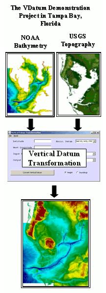
NOAA’s Vertical Datum Transformation (VDatum) Tool
Integrating America’s Elevation Data
The Vertical Datum Transformation (VDatum) tool developed by NOAA is designed to vertically transform geospatial data among a variety of datums. This transformation allows users to convert their data from different vertical references into a common system, thereby enabling the fusion of diverse geospatial data, particularly in coastal regions. Merging data sets with inconsistent vertical datums can cause discontinuities that become problematic when producing maps, assimilating data and advanced model results, or performing simulations at the accuracy needed for informed, intelligent coastal zone management decision-making.
VDatum currently supports vertical datum transformations for placement into three categories:
n Ellipsoidal: realized through space-borne systems, such as GPS.
n Orthometric: defined relative to a geopotential surface, and realized concurrently through geodetic bench marks.
n Tidal: a standard elevation defined from water level observations during a specific phase of the tide.
VDatum Enables:
n Fusing diverse geospatial datasets into one common vertical datum.
n Extracting consistent, non-interpreted tidal datum-based shoreline from Light Detection and Ranging (LiDAR).
The VDatum software tool is currently available for select areas of the United States and is designed to support many diverse applications. The VDatum tool allows transformation of a single depth/height, file/files of points, and specific GIS formats from one vertical datum to another. Uncertainties associated with VDatum are available to inform users and assist in transforming heights among the various supported vertical datums.
n Vertically referencing hydrographic surveys collected relative to the ellipsoid, eliminating time-consuming water level corrections.
For more information, contact NOAA:
n On the Web http://vdatum.noaa.gov
n By Email vdatum.info@noaa.gov
National Oceanic and Atmospheric Administration
Bathymetry
Vertical Datum Transformation
Forts, Ports, Canals, Wars
An Uncommon History of Tallahassee & Surrounding Areas by
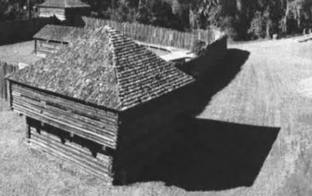
Replica of typical fort during the Seminole Wars (State Library and Archives of Florida) and
Dr. Joe Knetsch
CHAPTER 5
“Airy and Comfortable” or Life in the Forts During the Second Seminole War
Originally published in Apalachee Magazine, 1991-1996
Tallahassee Historical Society
Life in frontier fortifications has never been portrayed as glamorous or luxurious. This is especially true for forts located in Florida. Here the insects, vermin, alternate cold and hot, and the nearly constant dampness caused untold miseries among the United States forces stationed in the territory. Add to these native difficulties the constant skirmishes with the Indian foe, the complexity of an unnatural society of men forced to live with others of very different persuasions, religions, nationalities, and languages, and the trauma becomes more understandable. The misery of frontier life becomes almost too stark and bleak to bear with the routines of garrison life, the drudgery, the brutality of the officers, and the occasional violence frequently caused by bad whiskey. For many, such a life simply was too much, and suicide became a viable alternative.
Exactly what were these frontier outposts and how were they outfitted? In simple terms, there was no particular pattern to these posts and much was left to the ingenuity of the individual engineers assigned to construct these wilderness bastions of frontier defense. The most common construction was rectangular or square, with two blockhouses at opposite corners, which also became the symbol for such places on early maps. Some fortifications had a single, tall (three storied) blockhouse in the center of an enclosed area, for example, Fort Mellon, near modern day Sanford, Florida. Others, like Fort Pierce, were relatively open affairs with an officers’ quarters measuring 124’ x 18’ covered with boards, etc., with three 30’ x 15’ tarpaulin covered log enclosures for the enlisted men and a 28’ x 16’ hospital. The outside of such open affairs was guarded by rough hewn pickets loosely spaced, a protective blockhouse for the artillery piece(s) to fire from, and lower rooms for storage. Still other sites, such as Fort Drane, simply took existing buildings, incorporated them into the “picketification” using the buildings for the main
Forts, Ports, Canals, and Wars
housing of troops and officers. Historian Albert Manucy has described how these forts were constructed:
To build such a fort, you simply obtain a few hundred trees, cut them in 18foot lengths, and split them up the middle. Then you set them into the ground side by side like a fence, fastened them together with timbers, cut loopholes eight feet from the ground and build firing steps under the loopholes for the riflemen. Outside you dig a ditch that served as a kind of moat. You hung a strong gate, and your fort was practically finished.
Michael G. Schene, in his discussion of the construction of Fort Foster on the Hillsborough River, described the labors of troops sent to find suitable trees, preferably straight ones, then to cut them, drag them back to camp, split, and sharpen the logs into a point and place them into the ground so that ten to fourteen feet were left above the ground. They were fastened together with scrap lumber nailed to the flat side of the split logs (which faced inward) at the appropriate points and loopholes cut for the firing line, usually six to eight feet apart. 1
The army, never satsfied that all costs were being watched carefully, instructed the officers to keep costs down whenever possible. “As quarters have been erected at nearly all the stations,” one letter noted, “it is scarcely requisite to prescribe the kind of buildings to be put up. They should be made airy and comfortable of logs of pine [?] covered with clapboards and floored with puncheons a few nails etc. being all that the Qtr. Mrs. Dept. need furnish for their construction.” Another letter chastised an officer at Palatka for the large number of people employed in building that post. Only those “indispensable” to the operation of the fort should be used in the construc tion, for example, certain mechanics and laborers. Under no circumstances were costly buildings to be erected, especially on private property. “Huts of rough and cheap construction for supplies should alone be erected,” with temporary quarters (and most forts were allegedly temporary) to be built by troops themselves. 2 It almost appears as if the army tried to run the war in Florida on the cheap, but the army, being the army, could not resist the temptation of tearing one post down with troops while building the other side of the same post with hired labor, just to fulfill the contract. Cut, cut, cut, may have been the tone of the orders, but the “business as usual”
atti tude prevailed in the field.
Probably the largest problem in maintaining a fortification in the wilderness of Northern Florida was the acquisition of supplies. This logistical problem was fraught with difficulties because of the lack of roads, cleared rivers, canals, or other means to get the supplies to the posts. Even the most basic transportation needs, wagons and boats, were difficult (and someimes impossible) to obtain in the territory. On January 26, 1836, Acting Quartermaster General, Major Thomas Hunt, wrote to his operatives in Charleston and Savannah: “You will also purchase and ship about ten wagons, good and strong, if they can be procured without detention, suitable for Florida roads, with harness for six horses each. If you can get the wagons and harness conveniently, you are authorized to purchase fifteen.” By April the same officer was writing to Lieutenant Charles Dimmock, the Assistant Quartermaster at Savannah in extreme frustration over the lack of boats:
I have received your letter of the 3rd instant and regret extremely that the boats called for were not furnished. Why could they not have been obtained? Were there no workmen, no mate rials in Savannah? If the materials were growing in the woods, and you could find no other workmen than raw soldiers or plan tation negroes, the boats should have been built and furnished. It is perhaps too late to render them available; but they must be furnished cost what they may. You will therefore cause them to be built, if they cannot be purchased, and send them on immediately. During the last war, I took the materials from the woods where they were growing, and in less than four days had a sixteen oared boat completed and launched, which afterwards crossed Lake Erie. I therefore know that it was possible to have furnished the boats called for; and that which can be accompished by human means should not be left undone by a Department, on which, more than any other depends the efficient operation of the Army. 3
Wagons and boats depended on roads and waterways to get the supplies through and this, too, presented major problems. During Florida’s dry seasons, even such large rivers as the Apalachicola and Chattahoochee dropped to such low levels as to prevent normal passage of steamers or other large vessels. Of course, Indians themselves offered a menace to
Forts, Ports, Canals, and Wars
communication: “Information has reached here,” wrote Major Hunt, “that the Creek Indians are in open hostility and are in such force on the Chattahoochie as to interrupt the communication up that river, consequently large supplies of Subsistence Ordinance and other stores will, from necessity, have to be sent by way of Augusta, Georgia, to Fort Mitchell and its neighborhood. You will therefore furnish transportation for all Subsistence, Ordinance, and other stores. 4
Simply to supply the existing posts, therefore, was not an easy proposition and points to the importance of logistical planning in any military operation.
Because of the lack of provisions in the territory, many of the supplies with which to fight the Seminole War had to be purchased from outside the area. A letter of December 10, 1841, written by Quartermaster General Thomas Jesup, serves as an example of this point:
I herewith transmit a statement showing the quantity of Forage shipped to several depots in Florida since the 26th ultimo. Captain Crossman reports that his is now loading a vessel with hay at Boston destined for Tampa which will carry 700 bales, and one for Savannah which will carry 800. Captain Tompkins is loading a vessel at Philadelphia with Forage which will carry from six to seven hundred bales of hay and from six to eight thousand bushels of grain. Captain Dusenbery has taken up a vessel for the same depot which will carry about 7000 bushels of grain and will sail in a few days; and Captain Hetzel is now loading a vessel at Alexandria for Saint Marks which will carry about 8000 bushels of grain and is expected to sail on the 12th instant.
Cargoes from nearly every major port in North America were sent to Florida to fight the Seminole War because of the lack of provisions in the territory and their relatively high prices. 5 Transportation costs were correspondingly high, for the same reasons. It was economically cheaper to ship the forage and other supplies into Florida than attempt to purchase them within the territory where they did not exist in numbers great enough to sustain a war effort.
The army did attempt to get as much from the territory as possible, however, it was constantly dogged by poor quality and unscrupulous suppliers who did not hesitate to defraud the government. One of the more interesting series of letters in the Quartermaster General’s records involved a trio of men whom General Jesup accused of fraudulently selling and ship ping “bad bacon” to the posts in and around Tallahassee. The three men, John Ledgerwood, J.W Powers, and an M. Scott, allegedly sold bad bacon to the army and signed each other’s vouchers for the costs of shipment in their wagons and teams. According to Jesup’s letter of December 16, 1840, Powers worked in the Quartermaster General’s Tallahassee office, but did not have the power to sign receipts, while Ledgerwood declared that his name had been forged on false vouchers and used without his consent. He did, however, admit to signing accounts for the other two so they could receive their pay. Jesup, correctly, refused to pay these accounts because the entire transaction was fraudulent. Jesup, in a follow up letter of December 29, 1840, noted that he contacted District Attorney C. S. Sibley to press for criminal charges, but was advised that because of the “peculiar circum stances” of the country, prosecution was ill advised. 6 Jesup allowed the charges to be dropped.
Another of the constant complaints heard concerning the Florida operation was the use of public monies for private gain. Most of the private citizens’ claims for compensation are for lost plantation property, including slaves, dead or requisitioned horses and mules, compensation for work performed or payment for some depredation by either Indians or soldiers. James Riz and George Colee, for example, wanted the government to pay them for wood stolen from their property for the constuction of some military installation. However, it was known that Doctor Tripler and others in the vicinity, “had wood cut in that neighborhood for sale to steam boats, it is apprehanded that the wood here charged for was cut for that purpose.” More spectacular is the report filed on October 8, 1841, about the malfeasance of certain officials at Palatka:
A person by the name of Eaton, who served under the orders of Captain Waite as a Wagon Master, called at the office today and informed me that a person by the name of Bell, who has charge of public property at Palatka, frequently applies public labor to private objects. He says that negroes hired at high wages are employed in
YOUR FLORIDA GEOSPATIAL PARTNER
Duncan-Parnell, along with our valued partners, including Trimble and other top brands, are proud supporters of the Florida Surveying & Mapping Society. From solutions including GNSS, scanning, GPR, drones, and more to services including support, rentals, training, and repair, we are pleased to be your one-stop shop for geospatial professionals throughout the Sunshine State.
Jacksonville, FL (904) 620 - 0500
Orlando, FL (407) 601 - 5816
www.duncan-parnell.com
making rails, and public trams employed in hauling them, to fence a field belonging to Bell, and that a person employed at forty dollars a month, (one Hunt, sometimes called Knickerbocker) oversees them.
Eaton says that an Englishman by the name of John Dix, Clerk to Paymaster Brown, is allowed by the Quarter Masters Department a house for his mistress.
He mentioned one instance of Bell having taken a man from the train, a teamster, who was a tailor by trade, to make clothes for him, his family, or friends. He charged Bell with numerous speculations and informed me that Mr. Cole, the Sutler, could give information as to his improper conduct.
I will thank you to cause the most rigid investigation to be made, and if there has been very improper conduct on the part of Bell, to discharge him immediately. And no abuse like that stated in the case of Dix must be tolerated for a moment.
That such behavior as reported of Mr. Dix was not unknown in Florida’s frontier posts is reinforced by the knowledge that General Jesup once banned the use of hospital wagons because of the transportation into forts of very dainty soldiers and their leaving the said forts with equally dainty offi cers. 7 Florida’s war was notorious in northern circles as one which went to enrich the local population at the expense of the nation. However, though a few instances do appear on the record, the Seminole War was little different from any other war fought by U.S. troops.
The use of black slaves during the conflict was also noted in the official records and was the subject of many claims. Not only were these people subject to hard labor, but often, they were forced or asked to perform the dangerous duty of guide or spy for the troops in the field. Titus and Primus are two well known individuals who gave much needed guidance to U.S. troops who would otherwise have been lost in the Florida wilderness. Road duty was also an important job of black slave labor during the war, as Florida was ill equipped to facilitate heavy military or commercial traffic. One of the more notable facets of the use of slave labor was reported in the letter of March 25, 1841, concerning the direct paymens to slaves for extra labor performed. In this case, S. J. Sequi, of St. Augustine’s well known Sequi family, hired out some of his slave labor to work on projects in the Palatka
Forts, Ports, Canals, and Wars
area and signed for all of the wages earned, but turned over $10 to the slave for his extra time. Sequi informed Colonel F. L. Dancy, Florida Militia, of this transaction who, in turn, informed the Quartermaster General’s Office at Palatka. General Jesup, when informed of this transaction, questioned the direct payments to slaves and pointed to the uproar which occurred at Old Point Comfort under similar circumstances. Jesup, though acknowledging the need for slave labor at the southern posts, ordered the practice stopped on grounds that Congress would be upset and would question any payments made to slaves. Payments could only be made to owners and no sub pay ments to slaves were to be allowed. 8 Slaves as members of road crews, hired skilled laborers, guides, or servants were important to the war effort, and Jesup was quite correct in stating that slave labor was a necessity at most southern posts.
Of course, if a slave or any other person became sick, the medical practice of the day would be of little assistance, except to hurry them to the next life. And even though military posts were required by law to maintain gardens for the growing of fresh vegetables, little of the benefits helped those incapacitated by illness or wounds. Amputation was a way of life in the medical corps and was the most common answer to any infected area or wounded limb. Dr. Samuel Farrey, recalling to a colleague the operation he performed at Micanopy, noted that the patient had accidently discharged his gun, blew off two digits, smashed his thigh, with the ball finally lodging in his left wrist. He amputated the leg and the two digits only to watch the patient die within three hours, probably from shock. Any reader of Reminiscences of the Second Seminole War by John Bemrose (edited by John. Mahon) gets an immediate sense of the lack of scientific knowledge held by even the best of doctors on the Florida frontier. Bemrose himself, when sick with “country fever” asked Dr. Leavensworth to bleed him as a form of curing this dreaded disease. So common became the death of a soldier or other unfortunate, that this fine man became, in his own words, callous to the nature of humankind and careless in his duties. Even when progressive ideas, such as the ordering of ice for the benefit of the hospitalized were proposed, the bureaucratic mind precluded positive action:
I have received your letter of the 17th ultimo, covering one from Assistant Surgeon Hammond, recommending the erection of an ice house at Palatka and the filling it with ice for the use of the sick at the
different posts on the St. Johns river. There is no appropriation within the control of the Quartermaster’s Depart ment from which payment for ice could be made. 9
The main fears of the doctors in Florida were the fevers, miasma, swamp gasses, and infections, which they knew were beyond their powers to cure.
According to the diary of one Bartholomew Lynch, a common soldier during the Second Seminole War, the officers also lacked ordinary human kindness. The officer class, with the exception of all West Pointers, were uncommmonly brutal in their command of the raw recruits and common soldiers of the United States Army. Lynch describes barbaric beatings, the constant drunkenness of the officers, and savage orders to inflict uncalled for punishments for the least offense. A good example comes from his own experience at the hands of a Captain Fowler: “Captain Fowler struck me with a rifle and cut me without reason. I went to Gen. Taylor with my blood flowing. He laughed at me. It is no use to sue a devil if the Court be held in hell.” The case of Captain M. L. Howe, Second Dragoons, offers further brutality. Howe’s commanding general regretted learning that he “should have so severely punished one of his men as to have caused his death,” and thought that it should be handled only by the civil authorities. The U.S. District Court handled the case in its fall term of 1840. The charges against Captain Howe bring to light the severity of the crime.
Specification 1. In this that he, the said Captain M. L. Howe 2nd Dragoons did by beating, kicking, dragging on the ground a considerable distance, and having carried on a barrow or litter his head hanging down Pvt. James Jones of G Company 2nd Dragoons cause congestion of the Brain in him the said Jones thereby tending to the death of the said Pvt. James Jones this on a march from St. Augustine to Picolata, E.F. on or about the sixth day of December 1839.
Specification 2. In this that he, the said Captain M. L. Howe 2nd Dragoons did beat with a large stick, kick, have dragged on the ground, had placed in the Stocks, and while in the Stocks, have water thrown down on the said Pvt. James Jones G Company 2nd Dragoons all of which treatment caused the body of the deceased Pvt. James Jones immediately after death to have the appearance of putrid and spoiled flesh...
Forts, Ports, Canals, and Wars
Specification 3. In this that the said Cap M. L. Howe 2 Drag’s did when James Jones “G” Company 2nd Drag’s was nearly exhausted and unable to stand have him, the said James Jones put in the stocks and then have water thrown on him and that he said Cap M. L. Howe did say in reply to a request made by the said Pvt. James Jones to be killed and so get rid of his Captain Howe’s cruelty “damn you I have a grave ready to bury you in” to that effect, this on the march from St. Augustine to Picolata E Florida on or about the sixth day of December 1839.
Howe was additionally charged in the General Court Martial with conduct unbecoming of an officer in slandering the reputation of Captain T. Dade, cousin of the slain Major Francis L. Dade. 10 The obvious brutality exhibited by these charges indicates the level of primitive violence sometimes practiced by the officer class toward the non commissioned officers of the U.S. Army and gives more credence to the charges found throughout the Lynch diary.
The officer class could be equally petty and vindictive against members of their own group. In one of the more uniquely insipid incidents of the war, Major T. Fauntleroy attempted to bring charges against Colonel Thomas Hunt and Captain R. E. Clary, the former for not yielding his quarters to the Major who, at the post, was the Colonel’s temporary superior, and later for disobeying his direct orders to oust the Colonel, primarily because he obeyed the orders of the Colonel. The correspondence in this relatively silly melodrama shows the worst side of the officer class. The end result was that a Colonel does outrank a Major and the Captain was correct in following his superior’s direction. Major Fauntleroy had to wait until the Colonel transferred out of the area to obtain the prized quarters. 11
Some of the problems which appeared in the frontier fortresses came as the result of alcohol abuse. Much of the correspondence found in the “Letters Received by the Office of the Adjutant General” centers around the ready availability of whiskey and other spirituous liquors. (Of course, to call some of these liquid libations whiskey is to glorify the reality with a dignity unbe coming a good liquor.) At Micanopy, one man and his family were expelled from the vicinity, without any sympathy from the commanding officer, for selling whiskey to the soldiers of that post. General Walker
Armistead complained to Secretary of War Joel Poinsett that: “Black Creek without possessing one of the advantages of a Town, labors under its worst disadvantage, abounding in Grog Shops, and a riotous population, its jurisdiction is in constant conflict with the military authority & subversive of it ...” Armistead again, on June 2, 1840, put forth the proposition that: “... at several of our most important posts, a set of persons have taken up their residence, who are destitute of character, and who are in the habit of selling whiskey and other liquors to the troops ...” He also accused these same disreputable characters with selling whiskey and ammunition to the Indians. However, of this last charge, selling liquor to the Indians, the army itself was not totally innocent. On November 10, 1840, we read: “It is the direction of the Commanding General that three Barrels of whiskey be sent by the first opportunity to the Commissary at this post [Fort King] for issue to the Indians.” 12 The dispersement of liquor to the Indians served as an inducement for treaty making, which justified its distribution to the enemy.
More important for the future development of the state of Florida, were the normal duties of soldiers found in the frontier posts. Road building was one of the most important contributions made by the United States Army to the development of the territory. The road from Fort Frank Brooke to the falls of the Steinhatchee River was completed by the garrison at that post in early 1841. 13 Indeed, most of the roads connecting the outposts of defense were maintained or constructed by the garrisons of the nearest fortifications. This duty was routine, but for the development of future state of Florida, it was anything but routine. At the beginning of the war, few roads existed to aid in settlement; by the end of seven long years of warfare, the territory was partially blessed with a network of usable roads that could not have been constructed without the aid of the federal government and an influx of outside labor. For citizens of northern Florida, it should not be forgotten that the famed “Bellamy Road” was constructed by Captain D. Burch, under contract from Colonel William Bellamy, after the good Captain had constructed most of the road connecting Pensacola to Talla hassee.
The requirement, by a law of 1819, that each garrison should supply as much of its own forage, vegetables, fruits, etc. as possible, particularly in the form of a fort garden, had a benefit which many have not recognized. The “experiments” with various agricultural crops by the frontier posts often gave
H.O. Peters Surveyor of the Year Award
Rick Pryce
Jim Bennett Board Member of the Year Award
Earl Soeder
Life Member Recipient
Russell Hyatt
Fellow Member Recipients
Dodie Keith-Lazowick & Nick DiGruttolo
Committee Chair of the Year Award
Allen Nobles
Young Surveyor of the Year Award
Joe Samberg
Professional Excellence Award
Earl Soeder
Perry C. McGriff Outstanding Civic Contribution Award
Scott Woolam
Steven Woods Exceptional Service Award
John Liptak
Chapter President of the Year Award
Brion D. Yancy
Small Chapter of the Year Award
Indian River
Large Chapter of the Year Award
Manasota
clues to the incoming settlers regarding what type and variety of crops could be grown in a given location. For families coming into a new territory with a unique climate like that of Florida, this type of information could mean the difference between life and death. The frontier gardens of these isolated outposts proved to be of immense value to the new immigrants, especially during the period of the Armed Occupation Act of 1842.
Finally, no discussion of the life of soldiers in the frontier forts would be complete without acknowledging why they were established in the first place, that is to provide protection. The almost daily routine of cooking, gardening, latrine duty, and caring for the livestock pales in importance to this function. Daily scouts went forth from these bastions in the wilderness to face an unseen and frequently uncatchable foe. The constant marauding of the Indians, unpredictable and fast, left the soldiers, unfamiliar with the territory and disdainful of local militia assistance, constantly in fear of what lurked behind the next bush. Throughout the territory, from northern Florida to Cape Sable, the Indians were on the move. The daily reports of cattle, hogs, or horses lost to Indian depredations and theft almost befud dled the regular forces and many milita units with the Indians’ cunning and daring audacity. The sheer frustration of these brilliant tactics sometimes led to brutal reprisals on the part of the soldiers. However, the fact remained, the daily duty of scouting, scouring the country for Indian signs, and the frequent burning of Indian villages, pumpkin fields, etc., was the main duty of the garrisons stationed in Florida.
A full understanding of life in the “airy and comfortable” forts on the development of the Florida frontier has yet to be fully explored. The forts housed the men whose presence provided security for the territory’s citizens, and their labor on roads opened much of the central part of the state to settlement. The forts, damp and dreary as they were, played a dynamic rolein Florida's early development.
ENDNOTES:
1. For a good discussion of this fortification, see Arthur E. Francke, Jr.’s Fort Mellon, 1837-42: A Microcosm of the Second Seminole War (Miami, 1977). Two sketches of che fort appear on page 11 of the text. Mayor Thomas Childs to General Zachary Taylor. August 26, 1839, Letters Received by thee Office of the Adjutanc General (Main
Forts, Ports, Canals, and Wars
Series) 1822 1860, RG 94, National Archives Microcopy No. 567, (hereinafter Letters Received OAG), roll 98; For a general discussion of Fort Drane, see Joe Knesch, “Marion County’s Other Fort,” Marion County Historical Society (May 16, 1987); John Bemrose, Reminiscences of the Second Seminole War , ed. John Mahon (Gainesville, 1966); Henry Prince, “Prince Diary,” transcript by Frank Laumer at P. K. Yonge Library of Florida History, University of Florida; Albert C. Manucy, “Some Military Affairs in Territorial Florida,” Florida Historical Quarterly (hereinafter FHQ) 25 (October 1946), 205 06; Michael G. Schene, “Fort Foster: A Second Seminole War Fort,” Florida Historical Quarterly 54 (January 1976), 322 23.
2. February 1840 (fragmentary letter), Letters Received OAG. roll 218: Quartermaster General Thomas S. Jesup to Colonel Henry Whiting, April 12, 1841, Records of the Quartermaster General’s Office: Letters Sent, 1835 1842, RG 92, National Archives Microfilm, Three Rolls, (hereinafter Records QGO) roll 3, 382 33.
3. Major Thomas Hunt to Lieutenant Charles Dimmock, January 26, 1836, Records QGO, roll 1, 477; Hunt to Dimmock, April 267, 1336, Records QGO, roll 1, part 2, 132.
4. Hunt ro Dimmock, date not known, Records QGO, roll 1, part 2, 216.
5. Jesup to Whiting, December 10, 1841, Records QGO, roll 3, 376; Jesup to Captain W. L. Ketchum, September 28, 1841, Records QGO, roll 3, no visible page number.
6. Jesup to Ketchum, December 16, 1840, Records QGO, roll 3, 125; Jesup to Captain S. P. Hantzelman, December 29, 1840. Records QGO, roll 3, 151.
7. Jesup to Whiting, May 25, 1841, Records QGO, roll 3, 467; Jesup to Whiting, October 8, 1841, QGO, roll 3, 261; Jesup to (illegible), Records QCO, roll 3, illegible page number.
8. Jesup to Whiting, March 25, 1841, Records QGO, roll 3, 333 34.
9. Forrey to Phelps, August 1, 1837 in Samuel Forrey, “Letters of Samuel Forrey, Surgeon, U.S. Army”, 1837 1838, FHQ 6 & 7 (1927 28), 138 39; Bermrose, Reminiscences , 98 99; Jesup to Whiting, March 6, 1841, Records QGO, roll 3, 276.
10. Felix P. McGaughy, Jr., “The Squaw Kissing War: Bartholomew M. Lynch’s Journal of the Second Seminole War, 1836 1839” (masters thesis, Florida State University, 1965), 179; T. L. Thomas to Colonel D. E. Twiggs, December 11, 1839, Letters Received OAG, roll 217; W.W.S. Bliss to Twiggs, October 2, 1840, Letters Received OAG, roll 202; “Additional charges preferred against Capn M. L. Howe, 2nd Dragoons”, Document dated April 28, 1840, signed by Colonel David Twiggs, Letters Received OAG, roll 218.
11. Letters Received OAG, roll 202. Most of the correspondence in this series is dated November 9 and 18, 1840, and all letters are either to or from Lieutenant Colonel Thomas F. Hunt, Deputy Quartermaster General, then stationed at Palatka.
12. Lt. Colonel William Whistler to Secretary of War Joel Poinsett, January 20, 1841, Letters Received OAG, roll 241; Brigadier General Walker Armistead to Poinsett, May 28, 1840, Letters Received OAG, roll 201; Armistead to Poinsett, June 22, 1840, Letters Received OAG, roll 201; Armistead to “The Adjutant General, U.S. Army”,
Dr. Joe Knetsch
November 10, 1840, Letters Received OAG, roll 202. 13. L. Thomas to Colonel Davenport, January 11, 1841, Letters Received OAG, roll 217.
Dr. Joe Knetsch is the author of over two hundred articles and sixteen books, most of them concerning the state of Florida’s historty. Three of these books involve the Seminole Wars and their impact on Florida’s development. He is also a frequent reviewer of books on military history for the Journal of America's Military Past and authored regular articles for Professional Surveyor Magazine for over a decade. For twentyeight years he served as the historian for the Division of State Lands in the Florida Department of Environmental Protection. Dr. Knetsch lives in Tallahassee with his wife Linda and is now retired.
GET TO KNOW JAVIER
Javier Morejon has been a proud Hialeah resident for over 33 years and is ready to serve on day one. With a degree in Public Administration from FIU, leadership as Chairman of the Hialeah Beautification Board and former Vice Chairman of the Miami-Dade Historic Preservation Board, and firsthand experience in the surveying profession working with city government, Javier is dedicated to preserving Hialeah’s history while building a brighter future.
HIS PRORITIES
Fight to lower the rising costs of water and basic city services. Support our police and firefighters with the resources they need. Fix broken roads and address drainage issues. Plant more trees and green spaces to beautify our neighborhoods.
ARCHIVES FROM THE
BOUNDARIES AND LANDMARKS
A PRACTICAL MANUAL
BY A. C. MULFORD
Boundaries and Landmarks
Chapter III.
THE RELATIVE LEGAL VALUE OF EVIDENCES OF BOUNDARY
The description in the preceding chapter may be regarded as fairly representing that very large class of descriptions in which no dimensions are given but where the land is described by adjoiners and landmarks. Therefore it is manifest that the decisions of the surveyor must be based on two kinds of evidence only:
1. Landmarks in the field.
2. The claims of the adjoiners.
The subject of landmarks must be taken up in detail separately, while the same laws which govern the description of the land in question will also apply to the descriptions of the adjoiners’ lands.
Before going farther it may be well to note briefly the order of importance which the law assigns to the different kinds of evidence which come under the cognizance of the surveyor.
In a book entitled “The Law of Operations Preliminary to Construction in Engineering and Architecture” by John Cassan Wait, M.C.E., LL.B (John Wiley & Sons, 1900), the author has taken up very fully from a legal standpoint the problems of the surveyor. A few quotations from the chapter entitled “Description. Conflict of Calls” throw much light on the relative value of the evidence in ques tion.
Mr. Wait says:
“The calls as generally adopted to locate a survey are in the following order, viz.: (1) monuments or marks on the ground; (2) calls for adjoiners; (3) courses and dis tances; (4) quantity or area. If the
marks found upon the ground conflict with the calls for adjoiners, with the courses and distances, and with the area, the marks upon the ground, i.e., the monuments, must still govern.
“The monuments themselves need not exist, for where they are gone they may be supplied by proofs of their former existence.
“The rule is well established that where land is de scribed by courses and distances, and also by calls for adjoiners, the latter will govern if there be a discrepancy and there are no monuments.
“The third factor in order of importance is the course, which is usually held to govern the distance.
“As quantity or area is directly dependent on courses and distances, being calculated from them, it should be controlled by them.”
Under the general head of Marks in the Field the same author says:
“The highest and best evidence of the location of a tract of land is that furnished by the monuments found on the ground and which have been made for that particular tract.
“The line originally run, fixed and marked is the true boundary line that will control irrespective of any mis takes or errors in running and marking the line.
“The marks on the ground of an old survey, indicating the lines originally run, are the best evidence of the loca tion of the survey.
“The position of old fences may be considered in ascer taining disputed boundaries. As between the old bound ary fences and any survey made for the monuments after dispute, the fences are by far the better evidence of what the lines of the lot actually were.”
The first duty of the surveyor in running out a descrip tion without dimensions must therefore be to look for
1. Landmarks especially named for the piece of land in question, such as the “large stone” in the foregoing de scription;
2. The marks of a previous survey;
3. Indications of old fences.
If he cannot find sufficient evidence in one or more of these classes he should take up the claims of adjoiners, and if these again prove insufficient for locating the line he should urge all parties interested to settle upon a new boundary line by common agreement.
But the search for the landmarks must come first.
Chapter IV.
LANDMARKS.
STAKES AND STONES.
Certain landmarks may be specifically mentioned in a description. These may perhaps be called special land marks and must be identified as far as possible from the characteristics named in that description. But beside these there are a large number of general marks not mentioned perhaps in the deed, but which are nevertheless of the greatest possible value. Yet there can be no hard and fast classification of these, because they vary greatly with locality. On Long Island, where the most of my own work lies, there are certain marks which are of the highest impor tance, yet their use is confined largely, if not entirely, to Long Island. From the great abundance of yellow locust and the great capacity of its wood for resisting decay, it is used almost exclusively for surveyors’ stakes in this section. “To a locust stake” is the typical phrasing of a Long Island description. It is
preeminently the surveyor’s mark for the locality, yet it is manifestly not a landmark for regions where the yellow locust does not grow. For the reason that stones of glacial origin are plentiful in the hills of the North Shore and scarce on the plains of the center and the South Shore the interpretation of the meaning of stones as indicating old boundaries differs considerably in localities actually separated by perhaps only a dozen miles. The nature of landmarks or, more accurately speaking, of the marks employed to indicate a boundary, may therefore vary greatly with the locality, and it is imperative that the surveyor should at once familiarize himself with the usages which prevail in the section where he is working. There are, however, certain kinds of landmarks which are widespread in their general use, though local custom may modify even these somewhat. The following may be regarded, I think, as the most important:
The Stake. — A stake of some sort, driven down to mark a corner or a point where the course breaks, is one of the most universal landmarks. Besides the “corner stakes” one or more “line stakes” are frequently driven at different points on a long straight line to assist in following its direction.
Stake and Stone. — A stake is often reinforced and emphasized by having a stone laid beside it, as shown by Fig. 1. Sometimes there is a stone placed on either side, as shown by Fig. 2, and at times there are found four stones placed symmetrically around a stake, like in Fig. 3. Sometimes there is
SURVEYOR ULTRA
Versatile and lightweight. Penetrates dense canopy and captures accurate ground models for forestry, mining, and infrastructure.
VOYAGER
Precision redefined: ultra-dense, long-range LiDAR delivering unmatched accuracy from UAV or helicopter.
NAVIGATOR
Shallow-water bathymetric LiDAR for rivers, wetlands, and coastal mapping.
PRECISION MAPPING. ANY INDUSTRY. ANY MISSION.
Frontier Precision Unmanned + YellowScan LiDAR
From shallow-water bathymetry to large-area forestry, mining, and infrastructure, Frontier Precision Unmanned delivers the unmatched accuracy of YellowScan LiDAR — integrated on drones or helicopters for any application.
As America’s largest and most trusted YellowScan dealer, Frontier combines the industry’s top LiDAR sensors with decades of geospatial expertise and full-service support. Whether you’re surveying corridors, monitoring coastlines, modeling terrain, or inspecting utilities, Frontier Precision Unmanned provides the tools, training, and experience to ensure your LiDAR investment delivers real results.
With Frontier’s broad lineup of drones, sensors, and software, you’ll find the right system — at the right scale — for your industry.
Partner with Frontier Precision Unmanned — your trusted U.S. YellowScan dealer.
a little irregular pile, as shown by Fig. 4. The stone and stake are more frequently used at prominent angles of a piece of land, shown by Fig. I. There seems to be little question that in these cases the stake is the actual corner — the stone simply emphasizes it.
different way. In these cases the owner of a piece of land selects a large stone having two faces meeting at approximately the same angle as do the two courses which join at the corner which he intends to mark. He then places the stone entirely on his own land, fitting the angle of the stone into the angle of the courses, so that the two faces coincide with these courses — Fig. 6 shows such a case. In case a stone with suitable faces cannot be found or in case the angle is of more than 180 degrees, he frequently takes a
The Stone. — A stone set up for a landmark is a very ancient way of defining land, but like many ancient customs it is very vague. In sections where large stones are so scarce as to make them valuable for marks, a common custom is to place the stone or heap of stones squarely on the corner. The center seems to be the angle point. Such a large stone frequently defines a corner in unfenced land (Figs. I and 5).
In other places, more usually in fenced land, there are stones used as markers in a very
stone with one strong angle and places this angle coincident with the point of junction of the courses, as you will see by Fig. 7. Where wellmarked fences are still standing it is easy to interpret this corner. Sometimes the stone is so happily shaped that the meaning is clear, but where there is the slightest trace of doubt, prompt inquiry should be made as to who originally placed the stone. As far as the author has been able to observe, these stones present some or all of the following characteristics: (I) they possess one par ticularly conspicuous angle, (2) they have every appearance of having been placed artificially, (3) they are usually on end or on edge. The presence of these characteristics will generally suggest when this form of marking has been used, though the common corner stone may sometimes present some of the same characteristics. These private angle stones have been mistaken for common corner stones and the station made over the center, where there was no possible doubt that it should have been made at the edge. In such cases the surveyor should collect all the evidence he can and then decide in favor of the balance of proba bility.
Fence Stones. — There is one other class of stones which is to be found in some sections and which is of the greatest importance. Reference is made to the so-called "fence stones." In certain sections the oldest fences were almost invariably of the zigzag rail type known as " worm," "snake" or "Virginia rail." Under the apex of each zigzag, where the ends of the rails crossed, it was the cus tom to place a stone in order to raise the lower rail from the ground and prevent its decay. This is particularly true on Long Island. The old fences have long since dis appeared and_ new fences have been erected in their place, or it may be that hedgerow and forests have reclaimed their own; but there the ancient stones lie in two parallel rows, the individuals of
one row alternating with those of the other. The line always ran down the center of such a fence and therefore now lies midway between these two parallel lines of stones. The points at which the line breaks are to be found by ranging out the rows, the course changing where the range of the fence stones changes. It should be remembered, however, that where these stones lie on steep earth hillsides they have a tendency to slide down hill. Also there are few people who have the ability to “line a fence” straight across hill and hollow. So it not unfrequently hap pens that where an old map or survey shows unmistak ably one long straight course, the fence stones may show half a dozen short ones, the average being identical.
The value of the fence stones cannot be over-estimated and the illustra tion, Fig. 8, will at once show the conditions. Once I was called upon to survey an old farm which had ac quired value and was to be sold by the acre. There existed a good map of the land made early in the last century, but at different times small tracts had been purchased and added to the farm while in other portions of it sections had been sold off, so that the boundaries were very uncertain.
Along the back line for about 700 feet the fences had entirely disappeared, the wood had been cut off and after the axe had come
SUPPORT FSMPAC TODAY!
Your contribution can make a monumental difference in ensuring that our profession thrives and our voices are heard where it matters most.
Join FSMPAC and become a driving force for the future of Surveying & Mapping in Florida.
FSMPAC, the Florida Surveying & Mapping Political Action Committee, is your ticket to shaping the future of our profession. Our mission thrives on the generosity of dedicated Surveyors and Mappers who want to champion and safeguard our profession.
Your contributions go toward researching, identifying,and supporting candidates who champion our concerns.
Le arn More & Donate Here
the fires. The whole had “come up again to sprouts.” The owner, who had been born on the land, twice endeavoured to show me the line. The second time he got lost and, when he found himself, was half a mile distant from the farm itself. At least one fence stone was found about where the line should be, then a second and then a third in close prox imity. These gave the direction in which to work. Finally, by searching at the proper intervals, digging away the mold here and prodding with a range marker there, nearly every stone of the series was found. Finally, when the survey was plotted, it was found that the fence stones marked the original back line of the old map, the only difference being that the map gave one long straight course and the fence stones six or seven short courses (Fig. 9 shows the conditions). In searching for fence stones it should be remembered that the rows are usually about four feet apart and that the rails which they supported were twelve feet in length. In some cases I found that old fence stones were removed to be used for other purposes. The holes, however, which were left in digging them out, will often mark their former location for some years.
Fence stones are almost always landmarks of long standing, for while new rails are often laid on the old stones, it is doubtful if this form of fence is ever erected along new lines at the present time, — the post-and-rail fence and the wire fence have succeeded it,—and the zigzag fences now standing probably represent later erections on old foundations.
In determining the point where fences of this sort come together at an acute angle, care should be taken to extend the ranges of the two fences to their logical intersection, as it is a very common practice to join the rails across from one line to the other before the actual point
of intersection is reached.
In conclusion it may be fairly said that in the fence stones you have not one or two boundary stones but a consecutive series so numerous that the loss of a number of members makes no essential difference. I have found them to be universally considered landmarks so ancient and so clear that controversy might not extend beyond them. If the fence stones were found, all the parties concerned were completely satisfied.
There is one other arrangement of stones which may be regarded as a very good landmark. It is a common cus tom to throw the small waste stones picked up on culti vated fields under the fences which border these fields. These collections of stones often furnish an excellent method of determining the general location of a long vanished fence, as you will see by Fig. 10. The belt which they occupy is often several feet wide and they may origi nally have been thrown only on one side of the fence; but they are often of the very greatest service in deter mining the approximate position of a boundary line. They must not be confounded with the “fence stones” among which they may lie.” •
Past Presidents
Past Presidents
James M. King
Past Presidents
Past Presidents
Past Presidents
Robert
Jackson, Jr.
Dan Ferrans
David
Schryver
Past Presidents
Lou Campanile, Jr.
Robert Strayer, Jr.
Dianne Collins
Don Elder
Richard Pryce
Hal Peters
Lou Campanile, Jr.
Howard Ehmke
Dale Bradshaw
The Florida Surveying and Mapping Society has an eLearning Platform that is linked to your FSMS membership account .
When accessing the eLearning platform, use your FSMS membership username and password to log in. (Not Available for Sustaining Firm Memberships)
As always, Correspondence Courses are available by mail or email.
Updated Correspondence & eLearning Courses:
• Writing Boundary Descriptions
• Basics of Real Property
• Map Projections and Coordinate Datums
• Elevation Certificates and the Community Rating System
• Datums (eLearning Video Course)
• FL Surveying and Mapping Laws
Please email communications@fsms.org to notify us of
Advertise With Us!
All advertisements contained within the publication are published as a service to readers. Publication of the advertisements does not imply or express any endorsement or recommendation by FSMS.
Benefits: Full color; hyperlinks added to your webpages as well as email addresses.
Requirements: Contracts for one year (11 issues) receive 10% discount if paid in advance; 15% for Sustaining Firms. (Ads should be in jpeg, pdf, or png format)
New ads and/or changes are due by the 25th of each month.
Questions? Call our office at (850) 942-1900 or email at communications@fsms.org