

T he F lorida Surveyor


Call us t o g et your complete work flow s olution today ! Efficiency and versatility that will accelerate productivity comes part of a workflow solution that includes the FC-6000 field controller, Magnet software, a HiPer VR receiver and the GT-1200/GT-600 single-operator robotic system. The power of longrange reflectorless measurements comes in your choice of 1”, 2” or 3” GT-1200 models or 2”, 3” or 5” GT -600 models.


The F lorida Surveyor is the official publication of the Florida Surveying and Mapping Society, also known as FSMS. It is published monthly for the purpose of communicating with the professional surveying community and related professions who are members of FSMS. Our award winning publication informs members eleven months out of the year about national, state, and district events and accomplishments, as well as articles relevant to the surveying profession. In addition, continuing educational courses are also available.
PRESIDENT’S Message
April 2025

Members,
I had a wonderful time at the Quad-County (Dade, Broward, Palm Beach, Indian River) meeting last month. I think there were 115+ people there to celebrate National Surveyors Week, but more importantly, we celebrated our Profession with our friends, colleagues, and peers!
The celebration was held at the Student Union Hall on the Boca Raton Campus of FAU and the Chapters did a wonderful job of setting up and catering, so it turned out to be a huge success.

These events, and there have been multiple around the State this year, take so much planning, organization, and some really tough decisions down to the last minutes before, so the Chapter members really need to take a minute to recognize all of the people involved that made it happen and say thank you to them. We also can’t forget all of the companies that sponsor these events, because without their generous contributions they could not possibly happen.
Our FSMS Legislative committee headed by Mr. Jack Breed has been deeply involved with keeping us informed of the different Senate bills out there that are threatening our profession. Our committee’s success rate is tremendous and has definitely been helped by our friend and Lobbyist David Daniel and his firm Smith, Bryan & Myers. They are quietly fighting behind the scenes, guiding us to which Legislators are our friends so we can support them through our FSMPAC fund and ensure a successful end game. The end of the legislative session is May 1, and it looks very promising that our Legislative Team (Committee & Lobbyist) will be successful again, but we have to wait till then, so stay tuned in and continue to help fight with your donation to FSMPAC .
PRESIDENT’S Message
On another note, the Annual Conference is July 30th through August 2nd at the Naples Grande Resort, you can plan early and get your hotel reservation now so don’t delay.
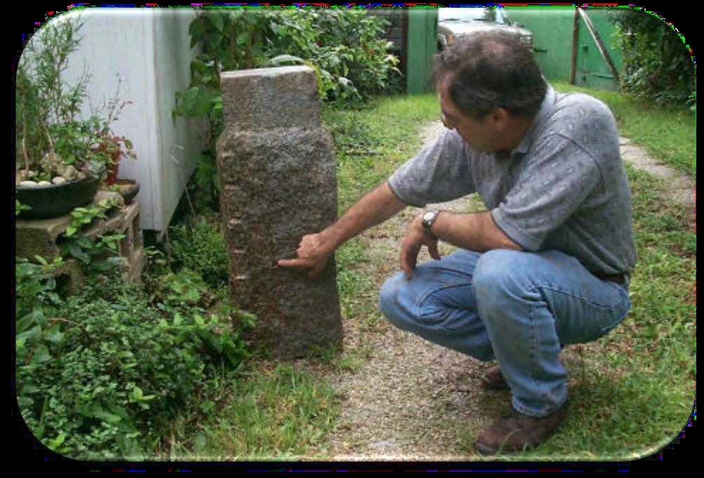
Survey History: Some of you know that one of my passions is Surveying history and bringing it forward to now whenever possible. I gave a brief presentation at the Quad-County Meeting on a part of the Coastal Survey done in 1855 by superintendent A.D. Bache, grandson of Benjamin Franklin. I focused on two accurate 4-mile baselines that A.D. Bache established in Florida that year. One at Key Biscayne and one at Cape Sable.
The Key Biscayne baseline , A.D. Bache’s field crews set two stamped and elaborate 16” x 16” x 31” granite monuments on top of a 35” x 40” x 28” deep granite base, North Base and South Base. He also set 12” x 12” x 36” granite monuments at each mile post between. In 1970, a granite monument was accidentally uncovered by a bulldozer in Key Biscayne Golf course. This started an elaborate chain of events. James Frasier, PLS, a Miami Dade county surveyor, spent 2 years researching and created a report of his findings in which he determined it was the North base and part of the A.D. Bache Coastal survey. Using his research and calculations, he searched for the South Base and determined it would be south of the Lighthouse and about 300 feet out in the ocean due to erosion.
In 1978, the Miami Dade chapter of the Florida Society of Professional Land Surveyors (FSPLS) got together and calculated the position of the South Base, triangulated it with two transits on shore and divers went down and found it laid over in 12 feet of water.
It took 10 more years, but a collaboration of FSPLS, FDOT, the Cape Florida State Park and the Airforce Recovery & Rescue personnel and their helicopter, recovered the monument and brought it ashore where it stands today. Both North and South bases have a plaque and are a shining example of our Survey History.
In the early 1990’s two more Dade County surveyors (Ted Riggs & John Liptak) searched for and found all three of the granite mile post monuments.
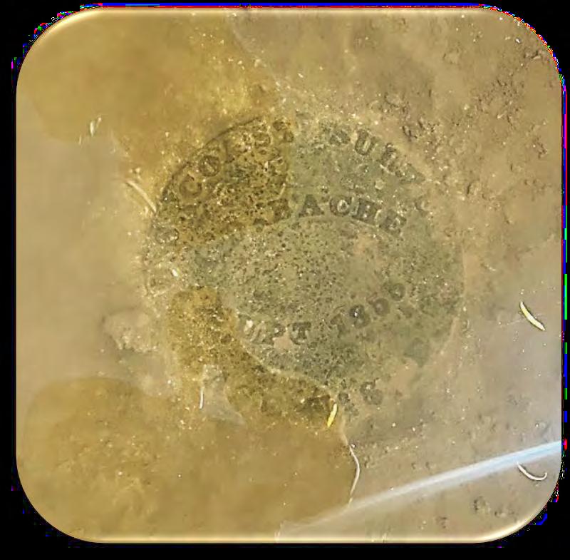
The Cape Sable baseline , A.D. Bache’s crews set 9 inch stamped disks on top
of Screw Pile monuments for the East and West Bases for this baseline. My research found that screw piles were used for lighthouses and beacons back in 1855, and were 9 inches in diameter by 9 feet long cast iron pipes that had a pointed screw type end and were screwed into the ground by a cog placed on top with metal spokes that rotated into the ground or reef by 4-5 men. Based on A.D. Bache’s 1855 report which I found in the Coastal Survey archives, the only granite monument on this baseline was Mile Post 2 in the middle.
In the past 4 years two surveyors have taken it upon themselves to search for the Cape Sable baseline monuments. Mike Bartholomew of Biscayne Engineering (now part of Atwell), hiked and kayaked with his son upon the Cape Sable trail route and found and documented the East Base screw pile monument. He also searched for the mile post 2 monument but did not find it.
Another Surveyor, Brion Yancy of Indian River Chapter, took up the challenge and this year found the Mile Post 2 (aka MidPost) monument which is a 12 inch x 12 inch granite monument with a brass nail in the center of the top roughly within 2 feet of where Mike had searched.
This is an example of two adventurer surveyors of today, testing their muster and research abilities against the salt marshes and the mosquitoes that come with it to find part of our history that still exists out there.
The Coastline Surveys were established in 1807 under the instructions from Thomas Jefferson himself knowing and understanding the need to i dentify and accurately map the coast of the new United States of America. This mandate was carried forward through to 1848-1855 when the official accura te surveys were commenced under Superintendent A.D. Bache, and the rest is history, but these examples are in Florida.
Respectfully submitted,
Richard D. Pryce, RLS/PSM


Recovery of South Base –


Recovery of Mile Posts on Key Biscayne


The Cape Sable Baseline Adventure


Basemap by Mike Bartholomew
Recovery of East Base – Cape Sable
Mike Bartholomew, PSM


Recovery
of Mid Base (Mile Post 2) – Cape Sable
Brion Yancy - PSM


2024-25 Districts and
Directors
District 1 - Northwest
Bay, Calhoun, Escambia, Franklin, Gadsden, Gulf, Holmes, Jackson, Jefferson, Leon, Liberty, Madison, Okaloosa, Santa Rosa, Taylor, Wakulla, Walton, Washington
Angela Bailey (850) 559-5039 bailey.angelak@yahoo.com
Chad Thurner (850) 200-2441 chad.thurner@ sam.biz
District 2 - Northeast
Alachua, Baker, Bradford, Clay, Columbia, Dixie, Duval, Gilchrist, Hamilton, Lafayette, Levy, Marion, Nassau, Putnam, Suwannee, St. Johns, Union
Nick Digruttolo (863) 344-2330 ndigruttolo@pickettusa.com
Pablo Ferrari (904) 219-4054 pferrari@drmp.com
District 3 - East Central
Brevard, Flagler, Indian River, Lake, Okeechobee, Orange, Osceola, Seminole, Martin, St. Lucie, Volusia
Al Quickel (352) 552-3756 alq.fsms@gmail.com
Brion Yancy (772) 475-7475 byancy@bowman.com
District 4 - West Central
Citrus, Hernando, Hillsborough, Pasco, Pinellas, Polk, Sumter
Tim Morris (813) 506-4015 tmorris@civilsurv.com
Alex Parnes (813) 493-3952 alexwolfeparnes @gmail.com

2 3 4 7 6 5
District 5 - Southwest
Shane Christy (941) 840-2809 schristy@georgefyoung.com
Donald Stouten (239) 281-0410
gunnydutch @gmail.com
District 6 - Southeast
Broward, Palm Beach
John Liptak (786) 547-6340 johnliptak@icloud.com
Earl Soeder (954) 818-2610
earl.soeder@ duncan-parnell.com
District 7 - South
Miami-Dade, Monroe
Jose Sanfiel (305) 375-2657 psm5636@gmail.com
Manny Vera, Jr. (305) 221-6210 mverajr@mgvera.com
Director
Russell Hyatt (941) 812-6460
russell@hyattsurvey.com
Charlotte, Collier, DeSoto, Glades, Hardee, Hendry, Highlands, Lee, Manatee, Sarasota
Jeff Simmons jas@nwfls.com
Coast
Jonathan Gibson jgibson0102@gmail.com
Chipola
Jesse Snelgrove jsnelgrove@ snelgrovesurveying.com
FL
Jeremiah Slaymaker jslay@wginc.com
2024-25 Chapter Presidents
Brandon
brndrbbns@netscape.net
Jeremy D. Hallick jdhallick@hotmail.com
ahwbenoit@gmail.com
2024-25 Committees
Standing Committees
Nominating Committee
Bob Johnson
Membership Committee Don Stouten
Finance Committee Bon Dewitt
Ethics Committee Shane Christy
Education Committee Greg Prather
Constitution & Resolution Advisory Committee Pablo Ferrari
Annual Meeting Committee Allen Nobles
Legal & Legislative Committee Jack Breed
Surveying & Mapping Council Randy Tompkins
Strategic Planning Committee Bob Johnson
Executive Committee Rick Pryce
Special Committees
Equipment Theft Manny Vera, Jr.
Awards Committee Howard Ehmke
UF Alumni Recruiting Committee Russell Hyatt
Professional Practice Committee Lou Campanile, Jr.
Workforce Development Committee Lou Campanile, Jr.
Liaisons
CST Program Alex Jenkins
FDACS BPSM Don Elder
Surveyors in Government
Richard Allen
Academic Advisory Justin Thomas UF / Earl Soeder FAU
FES
Lou Campanile, Jr.
Practice Sections
Geospatial Users Group
Young Surveyors Network
Richard Allen
Melissa A. Padilla Cintrón, SIT

round the State A
From Justin T. Thomas, PSM
I could not be prouder of these students for the work they put in to prepare for this event in which they placed second! Some students traveled from South Florida to Gainesville to practice and generate the camaraderie that organically develops in opportunities like the Student Competition. At the National level, these students represented Florida as a whole, and they did an amazing job!
I wanted to thank all of you who spent time with our students, answering questions and providing support in the preparation for this trip. The opportunity to attend this NSPS meeting can be a once in a lifetime for most student. The biggest takeaway from these types of events is that our industry is not limited to the City, County or State that we exist in. There are others around the country who are just as passionate about and dedicated to the furtherance of our profession. Needless to say, the value of this experience is priceless.
Justin T. Thomas, P.S.M., UF Lecturer
jthomas88@ufl.edu (352) 392-4996

Day – 1: (Pictured L to R)
Jared Foley, Augustus Benoit, Austin Rupert and Doug Stoner getting familiar with the T2 the night before the competition begins.
Day – 1: Calibrating the Gunters Chain the evening before the competition begins. (Pictured from L to R) Jared Foley and Augustus Benoit.


2:

Day – 2: Jared Foley sighting the Washington National

Day – 2: (From L to R) Doug
Day –
Team photo before the competition starts near the Washington National Monument. (Pictured from L to R) Doug Stoner, Emily Hawkins, Marla Horn, Augustus Benoit, Jared Foley, Austin Rupert and Justin Thomas.
Stoner, Austin Rupert, Emily Hawkins, Augustus Benoit and Marla Horn working on computations after collecting angles with the T2.
Monument as a backsight to measure angles to the Jefferson Pier.

Day – 3: The UF Team at one of the remaining boundary DC stones set by Andrew Ellicott in the 1790s.(Pictured L to R)
Emily Hawkins, Austin Rupert, Jared Foley, Augustus Benoit, Marla Horn and Doug Stoner.
Day – 2: UF team photo taken with the Surveyor's Compass used in Competition. (Pictured from L to R) Justin Thomas, Kenneth Dell (FLYSN Rep.), Marla Horn, Jared Foley, Austin Rupert, Augustus Benoit, Emily Hawkins and Doug Stoner).

Day – 2: The UF team performs COGO computations to stake out an easement boundary using a Robotic Total Station.
(Picture from L to R) Jared Foley, Marla Horn, Augustus Benoit, Doug Stoner and SAM/Trimble Rep.


3:

– 3: The UF
their last

DC


Day – 4: Full team award photo (Pictured from L to R) Marla Horn, Augustus Benoit, Austin Rupert, Jared Foley, Doug Stoner, Emily Hawkins and Justin Thomas
Day –
The UF Team at the NGS monument located outside the NGS Headquarters in Silver Spring, Maryland. (Pictured from L to R) Doug Stoner, Austin Rupert, Jared Foley, Augustus Benoit, Emily Hawkins, Kenneth Dell(FLYSN Rep.) and Marla Horn)
Day – 4: Students taking time after the competition to see the Lincoln Memorial and do the Gator Chomp. GO GATORS!. (Students pictured from Left to Right) Augustus Benoit, Marla Horn, Kenneth Dell (FLYSN Rep), Austin Rupert and Jared Foley.
Day
Team at
located
boundary stone set by Andrew Ellicott in the 1790s. (Pictured from L to R) Austin Rupert, Jared Foley, Kenneth Dell (FLYSN Rep.) Doug Stoner, Augustus Benoit, Marla Horn and Emily Hawkins.
(center)

NSPS Day on the Hill


Russell Hyatt, NSPS Florida representative and Bob Miller, past Treasurer of NSPS spent the day at the Capitol discussing surveying issues with staff in the offices of Senator Rick Scott, Senator Ashley Moody, and Representative Vern Buchanan.


From Raymond F. Phillips, PSM and Central Florida Chapter President
Attendance at the Tri Chapter meeting of the Florida Surveying and Mapping Society was well attended.

Held in Lakeland at Abuelo's, we had good company and good discussions about where the surveying community is headed and the need for Technicians and technician training.
From your President of the Central Florida Chapter and Host Chapter for this year.
University of Florida School of Forest, Fisheries, and Geomatics Sciences
The Florida Surveying and Mapping Society's 2025 Tri-County Meeting held at FAU on March 25, brought together about 100 members. SFFGS was well represented by Katie Britt, assistant director for geomatics extension, Dr. Hartwig Hochmair, professor and leader of the SFFGS Geomatics program at the Fort Lauderdale Research and Education Center (FLREC), and Todd Bates, PSM geomatics specialist. The annual event serves to support the FSMS mission and vision statements: "To promote, enhance and preserve the surveying and mapping profession through public awareness, education efforts, advocacy for the profession and legislative actions," and "To be the national leader in development of education programs, public/professional outreach and development of governmental policies for the Geospatial Community." It was great learning not only about the company but about the projects currently being worked on. Thank you all so much for taking the time to come out!


FSMS Past President John N. "Jack" Breed of CivilSurv Design Group, Inc. receives "The Geomatics Faculty of the Year Award," from Terrell T. “Red” Baker, Director, School of Forest, Fisheries, and Geomatics Sciences (FFGS).
Celebrating with FSMS Past Presidents (From L to R): Jeremiah Slaymaker 2011-2012, John M. Clyatt 2002-2003, Ray Niles 1996-1997, John N. "Jack" Breed 1999-2000, and Russell Hyatt 2013-2014.


Manasota, Charlotte Harbor, and Collier-Lee Tri-Chapter Meeting
From Greg Rieth, P.S.M., C.F.M.:
Pictures are from April 3rd, Tri-Chapter Meeting. The Charlotte Harbor and Manasota Chapters collected, on two separate occasions, 133 pounds and 159 pounds of tin tabs. The tabs were donated to Shriners Hospital. Thank you to all the volunteers and supporters!


University of Florida Geomatics Student Association
We’d like to give a big thank you to Stephen Dees, PSM and Eric M. Orndorff, MS, PLS, PSM from WGI for coming out this past Tuesday to talk about the company and many of the great services offered and projects they’ve been working on.
We’d also like to announce the new GSA Officer Board for the 2025-26 school year:
President - Austin Rupert
Vice President - Jared Foley
Treasurer - Jocelyn Wood
Secretary - Matt Edmunds
ROAR Officers - Reese Veerkamp, Emily Hawkins, SIT
ASPRS Representative - Briar Pierce
Congratulations to everyone elected!


CONGRATULATIONS TO Scott Graham of ETM (England-Thims & Miller)
Congratulations to our 2025 Recruitment Champion, Mr. Scott Graham of ETM.
He Recruited Two NEW Full Members as part of Our 2025 Membership Recruitment Contest.
Scott is the winner of a Conference Packet 1 Registration along with a Two Night Stay at the Naples Grande Beach Resort.
FSMS would like to thank all of the participants in this year's membership recruitment contest. Through all of your combined efforts, FSMS gained 27 New Members: 8 Full, 16 Associate, 1 Affiliate, and 2 Sustaining Firms.


Surveyors in Government
April 2025
Greetings All,
As I find everyone this April, we are beginning to see more and more of the warmer, dryer weather coming about. The Floridian summer that runs from May to October is fast approaching, and I know I say this as mainly and office worker, I do feel for our field staff that we could not do this without their effort. So I would definitely like to give them all a kudos for the hard work they do day in and day out. This month I hoped to write about challenges of transitioning from conventional methods into the 3-Dimensional collection environment, but recent legislative efforts have changed the direction of this article. This is because I see the responsibility of the Surveyors in Government Liasion as the person to work to keep everyone abreast in government of changes or issues that affect us all.
I have to say in the past week and a half I have been involving calls, emails, and discussions with others in local and county government. A big thank you to Matt Kalus, who with out him I would be oblivious. Even this morning I received a call from Danny Whittaker, both of whom work for Orange County Government. Matt Kalus made me aware of HB381 and SB784 , both of which involve the platting process and propose changes to Florida Statutes 177 Part I, and a host of other statutes outside of surveying. They work with different time ranges of plat review timelines and differ on reviews for preliminary plats, plats, and replats. They very in review timelines from 10 business days to 15 business days. H.B. 381:

Surveyors in Government
S.B. 784:


There is more covered in the proposed bills, but these are big issues for local and county governments and there current staffing levels. As proposed, I see the need to add to staff to adequately review the information required to approve and sign plats, whether preliminary or not. We have talked among surveyor as maybe just having this as a sufficiency review and reject plats without the required items right off the get go so it closes out the initial process.
This is what we have been discussing the past 10 business days, wondering what the legislators are going to require from us. We have been working with FSMS volunteers who deal with legislative issues, but remember FSMS represents all surveyors, not just government surveyors. There is infringement from many fronts, not just on governmental issues. Which leads me to my call this morning pertaining to movement of two separate bills. Those bills have to do with the deregulation of professions in Florida. I have not had a chance to look at those bills, but it does tell you of how things seemingly move quickly with legislation, but in looking back these have been moving for several months. The just have evolved as they have come through various committees. Why do I bring all of this up? It is because it tells us all that we have to get more involved in the process. It also tells me the value of political action committees, like FSMPAC and other organizations who have legislative chairs and committees.
Surveyors in Government
It takes us all being involved to keep track of what happens in Tallahassee and to have a say in what is proposed and then adopted. Be diligent in keeping up with what is being proposed.
Until next time my friends, I bid you adieux.
Thank you for taking the time to read this article!
Sincerely,
Richard Allen, City Surveyor for Orlando
FSMS Surveyors in Government Liaison President of the Geospatial Users Group
ASPRS Florida Region Director
407.246.2788 (O)
Richard.Allen@orlando.gov
PRECISION BEYOND BOUNDS

FRONTIER PRECISION UNMANNED SOLUTIONS
Frontier Precision has been leading the way in delivering innovative solutions – on land, air and underwater with our Unmanned technology. Now, every place on earth is reachable – with our UAS/ Drones, ROV’s, and LiDAR solutions. We help you with the latest technology to get your job done efficiently while keeping your business profitable.

UAS / DRONE DOCKS
The latest innovations in drones and docks to deliver the right product for the right UAS application.

LIDAR / SENSORS
LiDAR/Sensor solutions designed for precision data collection.
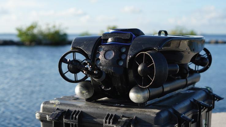
UNDERWATER ROVS
Deep Trekker’s underwater ROVs showcase proven durable and innovative solutions.
FRONTIER PRECISION | JACKSONVILLE, FL
Jordan Baranowksi | 904.855.9827 [Office] or jordanb@frontierprecision.com
FIND OUT MORE AT: www.frontierprecision.com/unmanned

70th Annual FSMS Conference
CONFERENCE REGISTRATION
July 30th – August 2nd at Naples Grande Beach Resort
Registrants Name: _______________
Packet 1 – Full Registration/Best Value
Member
Licensed Non-Member
Non-licensed
$400
$500
$350
Includes: (1) Wednesday Welcome BBQ ticket, (1) Friday Exhibit Hall Breakfast ticket, (1) Friday Exhibit Hall Lunch ticket, (1) Friday Recognition Banquet ticket, and (6) Saturday Seminar CECs.
Member
Packet 2 – Partial Registration
Member
Licensed Non-Member
Non-Licensed
$385
$485
$335
Includes: (1) Friday Exhibit Hall Breakfast ticket, (1) Friday Exhibit Hall Lunch ticket, (1) Friday Recognition Banquet ticket, and (6) Saturday Seminar CECs.
Packet 3 – Saturday Only
Licensed Non-Member
Non-licensed
$240
$340
$190
Includes: (6) Saturday Seminar CECs.
SATURDAY SEMINARS
August 2nd
Course options are listed below, please mark the circle next to the course. Choose only ONE course per time segment.
Course name:
8:00 am–9:40 am (choose one from this row)
2 Hour Course Options

FDEP - Sovereignty Lands/Water Boundaries, Murphy Act Lands and Board of Trustees Database (BTLDS)
(2 CEC’s – Course #11014)
Instructors: Scott Woolam, PSM & Eric Sellers, PSM
Course name:

10:10 am – 11:50 am (choose one from this row)
Course name:
Using GIS to Produce a Survey Drawing
(2 CEC’s - Course 11017)
Instructor: Frank Conkling, PSM, GISP
Course name:
The FDOT RW Map – Purposes and Benefits to the Agency and the Surveying Profession
(2 CEC’s - Course #11008)
Instructors: Brett Wood, PSM & Scott Fowler, PSM
Course name:
1:30 pm – 3:10 pm (choose one from this row) To Be Determined
(2 CEC’s – Course #TBD)
Instructor: To Be Determined
Surveying & GIS –Infrastructure Geospatial Partnership
(2 CEC’s - Course #11018)
Instructor: Richard Pryce, RLS, PSM
Course name:
Introduction to Construction Surveying Basics
(2 CEC’s - Course #11020)
Instructors: Clifford Culhane, PLS, PSM & Dionicio Montero, FAA Pilot
Course name:
Navigating Florida Statutes Chapter 177.073 – Embarking on a Journey to Allow Expedited Residential Permits with a Preliminary Plat
(2 CEC’s – Course #11022)
Instructor: Matthew Kalus, GISP-R, PSM, PE
Course name: Course name:
It Takes Time to Get Oriented (2 CEC’s – Course #11028)
Instructor: Brion Yancy, PSM
Preparing to Lead
(2 CEC’s - Course #11024)
Instructor: Paul Cortissoz, SPHR
70th Annual FSMS Conference
SIT ($300) / Wed. Seminars ($240) / Thurs Seminars ($120)
Wednesday Seminars (Separate Registration Required)
July 30
8:00 am – 3:00 pm ONLY CHOOSE ONE
Seminar I:
How to Prepare an Original Boundary Survey
(6 CECs - Course #11009)
Instructor: Dr. Davey Edwards, PhD, PLS, CFedS
Seminar II:
Expert Testimony: Neutral, Defensive, or Persuasive
(6 CECs - Course #11011)
Instructor: Kevin Norris, PLS, JD
SIT Prep Course (Un-Licensed Attendees, No CEC Credit)
July 30
8:00 am – 4:00 pm
Geoscholar's Florida Surveying and Mapping Society Fundamentals of Surveying (FS) Exam/Surveyor in Training (SIT) Certificate Prep Course
You must complete the online course before attending the Seminar. Dr. Lyle will be covering select questions over the required sections to help you with examination preparation. After the Seminar you will have access for 1 year to the online course.
Instructor: Dr. Stacey Lyle, PhD, RPLS, PLS
Thursday Seminars (Separate Registration Required)
July 31
8:00 am – 10:30 am ONLY CHOOSE ONE
Seminar I:
Undocumented Boundaries & the Surveyors Duty
(3 CECs - Course #11010)
Instructor: Dr. Knud Hermansen, PSM, PE, PhD, Esq.
Seminar II:
Surveying and Mapping with UAS
(3 CECs - Course #11013)
Instructors: Jib Ahmad, RPLS, PLS, CFM & Vas Kalogirou, RPLS, PLS, PS, PSM, LS
Complete payment information on the following page
Cancellation Policy:
30 days prior to conference: 50% refund
Less than 30 days to conference: No refund
202 5 S u S taining
A
AA Surface Pro, Inc.
239-471-2668
Accuracy Datum
863-599-8688
Accuright Surveys of Orlando
407-894-6314
A. D. Platt & Associates, Inc.
850-329-5551
Adventure Coast Orthomosaic & Mapping Solutions, LLC (ACOMS)
352-777-4077
AIM Engineering & Surveying
239-332-4569
Allen & Company, LLC
407-654-5355
Allen Engineering
321-783-7443
American Government Services Corporation
813-933-3322
American Surveying, Inc. 813-234-0103
Amerritt, Inc. 813-221-5200
AOI (Area of Interest) Solutions, Inc. 321-877-0056
Arc Surveying & Mapping, Inc. 904-384-8377
Associated Land Surveying & Mapping, Inc. 407-869-5002
ATWELL, LLC 866-850-4200
Avirom & Associates, Inc. 561-392-2594

B
Barnes, Ferland and Associates, Inc. 407-896-8608
Barraco & Associates, Inc. 239-461-3170
Bartram Trail Surveying, Inc. 904-284-2224
BBLS Surveyors, Inc. 239-597-1315
Bello & Bello Land Surveying Corporation 305-251-9606
Bennett-Panfil, Inc. 941-497-1290
Berntsen International 608-443-2772
BGE, Inc. 561-485-0824
Boatwright Land Surveyors, Inc. 904-241-8550
Bock & Clark Corporation(NV5) 330-665-4821
Bowman Consulting Group 703-454-1000
Braden Land Surveying 727-224-8758
Bradshaw-Niles & Associates, Inc. 904-829-2591
Brown & Phillips, Inc. 561-615-3988
BSE Consultants, Inc. 321-725-3674
Buchanan & Harper, Inc. 850-763-7427
F irm S Directory
CCalvin, Giordano & Associates, Inc.
954-921-7781
Campanile & Associates, Inc.
954-980-8888
Carnahan, Proctor & Cross, Inc.
407-960-5980
Carter Associates, Inc.
772-562-4191
Caulfield & Wheeler
561-392-1991
Chastain-Skillman, Inc.
863-646-1402
CivilSurv Design Group, Inc.
863-646-4771
Clements Surveying, Inc.
941-729-6690

Clymer Farner Barley Surveying, LLC
352-748-3126
Coastal Engineering Associates, Inc.
352-796-9423
Colliers Engineering & Design
732-383-1950
Cousins Surveyors & Associates, Inc.
954-689-7766
CPH Consulting, LLC
407-322-6841
Craven-Thompson & Associates, Inc.
954-739-6400
Culpepper & Terpening, Inc.
772-464-3537
DDeGrove Surveyors, Inc. 904-722-0400
Dennis J. Leavy & Associates
561-753-0650
Dewberry
407-843-5120
Donald W. McIntosh Associates, Inc.
407-644-4068
Donoghue Construction Layout, LLC. 321-248-7979
Douglass, Leavy & Associates, Inc.
954-344-7994
DRMP, Inc. 833-811-3767
DSW Surveying & Mapping, PLC.
352-735-3796
Duncan-Parnell, Inc.
800-849-7708
Durden Surveying and Mapping, Inc. 904-853-6822
E
ECHO UES, Inc.
888-778-3246
Eda Consultants, Inc.
352-373-3541
Eiland & Associates, Inc.
904-272-1000
Element Engineering Group, LLC. 813-386-2101
Engenuity Group, Inc.
561-655-1151
202 5 S u S taining
ER Brownell & Associates, Inc.
305-860-3866
ETM Suryeying & Mapping
904-642-8550
Exacta Land Surveyors, Inc.
866-735-1916 F
Ferguson Land Surveyors
727-230-9606
First Choice Surveying, Inc.
407-951-3425
Florabama Geospatial Solutions LLC
850-480-7467
Florida Design Consultants, Inc.
727-849-7588
Florida Engineering & Surveying, LLC.
941-485-3100
FLT Geosystems
954-763-5300
Ford, Armenteros & Fernandez, Inc.
305-477-6472
Fortin, Leavey, Skiles, Inc. 305-653-4493
Frontier Precision Unmanned 701-222-2030
F.R.S. & Associates, Inc.
561-478-7178
G
GCY, Inc.
772-286-8083
GeoData Consultants, Inc 407-732-6965
Geoline Surveying
386-418-0500
Geo Networking, Inc. 407-549-5075
GeoPoint Surveying, Inc. 813-248-8888
George F. Young 727-822-4317
Germaine Surveying, Inc. 863-385-6856
GISurv, LLC 954-651-5942
GPI Geospatial, Inc. 407-851-7880
Gustin, Cothern & Tucker, Inc. 850-678-5141
H
Hanson Professional Services, Inc. 217-788-2450
Hanson, Walter & Associates, Inc.
407-847-9433
H.L. Bennett & Associates, Inc. 863-675-8882
HUB International 850-386-1111
Hyatt Survey Services 941-748-4693 I
Ibarra Land Surveyors
305-262-0400
I.F. Rooks & Associates, LLC. 813-752-2113
J
JAVAD 408-770-1770
Johnston's Surveying, Inc. 407-847-2179
F irm S Directory
KKCI Technologies
954-776-1616
Keith and Associates, Inc.
954-788-3400
Kendrick Land Surveying, LLC
863-533-4874
KPMFranklin (407) 410-8624
L
Landmark Engineering & Surveying Corporation
813-621-7841
Land Precision Corporation
727-796-2737
L&S
Diversified, LLC.
407-681-3836
Langan Engineering and Environmental Services, Inc. 973-560-4900
Leading Edge Land Services, Inc. 407-351-6730
Leiter Perez & Associates, Inc.
305-652-5133
Lengemann Corp. 800-342-9238
Locklin Surveying & Mapping LLC 407-402-8897
Longitude Surveyors, LLC
305-463-0912
Long Surveying, Inc. 407-330-9717
Lynx Surveyors & Engineering 833-721-2907
M
Manuel G. Vera & Associates, Inc. 305-221-6210
Massey-Richards Surveying & Mapping, LLC. 305-853-0066
Masteller, Moler & Taylor, Inc. 772-564-8050
McKim & Creed, Inc. 919-233-8091
Metron Surveying and Mapping, LLC. 239-275-8575
Mock Roos & Associates, Inc. 561-683-3113
Moore Bass Consulting, Inc. 850-222-5678
Morris-Depew Associates, Inc. 239-337-3993
Murphy’s Land Surveying 727-347-8740 N Navigation Electronics, Inc. 337-237-1413
Northwest Surveying, Inc. 813-889-9236
O On The Mark Surveying, LLC. 321-626-6376
PEC Surveying & Mapping
407-542-4967
Pennoni Associates, Inc.
863-594-2007
Perret and Associates, Inc
904-805-0030
Pickett & Associates, Inc.
863-533-9095
Plan Right Surveying, Inc.
239-276-2861
Platinum Surveying & Mapping, LLC.
863-904-4699
Polaris Associates, Inc.
727-461-6113
Porter Geographical Positioning & Surveying, Inc.
863-853-1496
R.M.
Stoner Inc. 954-585-0997
Suarez Surveying & Mapping, Inc. 305-596-1799
Survey Data Solutions, LLC 352-816-4084
Survey Pros, Inc. 305-767-6802
SurvTech Solutions, Inc. 813-621-4929 T
T2 UES Inc. 407-587-0603
Tectonic Engineering and Surveying Consultants 845-534-5959
Thurman Roddenberry & Associates 850-962-2538
F irm S Directory
407-248-0160

70th Annual FSMS Conference
EXHIBITOR & SPONSORSHIP OPPORTUNITIES
July 30th - August 2nd, 2025 O Naples Grande Beach Resort


SOLD Exhibitor Opportunities
(*Only 1 Platinum Exhibitor Available)
PLATINUM EXHIBITOR *
$5,000
• Company Name and Logo on a Banner at the Registration Desk
• Company Bio and Logo in the Conference Program Book
• 1 month free full-page ad in The Florida Surveyor W: 8.5 in. x H: 11 in.
(Sustaining Firms will receive an additional free month )
• Recognition in the Conference Edition of The Florida Surveyor
• Homepage Banner Ad on FSMS.org for 2 months
• Logo with hyperlink to we bsite displayed on FSMS.org
• Complimentary full page ad in Con ference Program Book
• 2 night complimentary hotel stay
• Packet 1 Registration ( includes 1 BBQ ticket, 1 Exhibitor Breakfast ticket, 1 Exhibitor Luncheon ticket, 1 Recognition Banquet ticket, & 6 Saturday Seminar CECs )
• 2 Booths with a 5 amp electric power drop (outlet only)
• First priority when choosing booth(s)
• Complime ntary Valet Parking
• Vendor Spotlight: 30 Minute Priva te Room Speaking Opportunity (Limited Spaces Available, N o CECs)
GOLD EXHIBITOR
$3,800
• Company Bio and Logo in the Conference Program Book
• 1 month free half-page ad in The Florida Surveyor W: 8.5 in. x H: 5.5 in.
( Sustaining Firms will receive an additional free month )
• Recognition in the Conference Edition of The Florida Surveyor
• Logo with hyperlink to we bsite displayed on FSMS.org
• 1 night complimentary hotel stay
• Packet 1 Registration ( includes 1 BBQ Ticket, 1 Exhibitor Breakfast ticket, 1 Exhibitor Luncheon Ticket, 1 Recognition Banquet Ticket, & 6 Saturday Seminar CECs )
• 5 amp electric power drop (outle t only)
• Second priority when choosing booth(s)
• Complime ntary Valet Parking
• Vendor Spotlight: 30 Minute Priva te Room Speaking Opportunity (Limited Spaces Available, N o CECs)
Exhibitor Opportunities
SILVER EXHIBITOR
$2,300
• Company Bio and Logo in the Conference Program Book
• 1 month free half-page ad in The Florida Surveyor W: 8.5 in. x H: 5.5 in.
(Sustaining Firms will receive an additional free month )
• Recognition in the Conference Edition of The Florida Surveyor
• Logo with hyperlink to website displayed on FSMS.org
• Third priority when choosing booth(s)
• 2 Day Complimentary Self Parking
• Welcome-Bag Flyer Insert (Vend er Provided)
• 2 Welcome BBQ tickets
CONFERENCE EXHIBITOR
$1,800
• Company Bio and Logo in the Conference Program Book
• 1 month free half-page ad in The Florida Surveyor W: 8.5 in. x H: 5.5 in.
(Sustaining Firms will receive an additional free month )
• Recognition in the Conference Edition of The Florida Surveyor
• Last priority when choosing booth(s)
• Logo with hyperlink to website displayed on FSMS.org
ALL EXHIBITORS WILL R E CEIVE:
8’ x 10’ draped booth with 10’ backdrop and 36” side rails
7” x 44” booth identification sign
6’ draped table, 2 chairs and waste basket
4 name tags for booth personnel per booth
2 Exhibitor breakfast tickets per booth
2 Exhibitor lunch tickets per booth
Attendee List (By Request)
(Additional Booths can be Purchased for $950 per Booth)

$1,700
Sponsorship Opportunities
Refreshment Breaks (Company Name & Logo on Signage at All Seminar Refreshment Breaks along with a Full-Page Ad in The Florida Surveyor.)
$1,700
Registration Desk & Signs (Company Name & Logo on Conference Welcome Banner located at the Registration Desk. Assists with Conference Sign expenses.)
* $1,500 *O nly 1 Sponsorship Available!
Back Cover of Conference Program Book (Company Name, Logo or Ad placed on Back Cover of Conf. Program Book given to Attendees.)
$1,500
Banquet Door Prizes (Sponsorship of Prizes given at Recognition Banquet along with Company Name & Logo on Signage During Banquet.)
$1,500
Exhibit Hall Breakfast (Company Name & Logo on Signage during Friday morning Exhibitors Breakfast. Assists with Breakfast Expenses.)
$1,500
Legislative Reception (Company Name & Logo on Signage at Reception. Sponsorship assists with Speaker and Reception expenses.)
$1,200
Exhibit Hall Door Prizes (Company Name & Logo on Signage during Friday's Exhibit Hall Event, in addition to being Recognized during Raffle as a Sponsor.)
$1,200
Exhibit Hall Luncheon (Company Name & Logo on Signage during Friday's Exhibitors Luncheon. Assists with Lunch Expenses.)
$1,200
SIT Test Prep (Company Name & Logo on Signage outside of classroom.)
$1,000
Cornhole Tournament (Company Name & Logo on Signage during Wed. Cornhole Tournament.)
$1,000
Exhibitor Welcome Bags (Company Name & Logo on Conference Exhibitor Welcome Bags).
$1,000
Fishing Tourney/Trip (Company Name & Logo on Signage. Assists with Food, Drinks, & expenses.)
$1,000
Sponsorship Opportunities
Golf Tournament (Company Name and Logo on Signage. Assists with Food, Beverage, and Prize costs.)
* $1,000 *O nly 1 Sponsorship Available!
Inside Front Cover of Conference Program Book (Company Name, Logo or Ad placed Inside the Front Cover of the Conference Program Book.)
$800
Exhibit Hall Luncheon Cash Bar (Company Name & Logo on Signage at 1 Cash Bar serving Beer & Soda during the Friday Exhibit Hall Luncheon. Includes 4 Complimentary Drink Tickets.)
* $800 *O nly 1 Sponsorship Available!
Inside Back Cover of Conference Program Book (Company Name, Logo or Ad placed Inside the Back Cover of the Conference Program Book.)
$750
CST Exams (Company Name & Logo on Signage before & during Exam.)
$700
General Business Session (Company Name & Logo on Signage at & during Conference GBS.)
$500
Exhibitor Beverage Break (Company Name & Logo on Signage at Exhibitor Afternoon Beverage Break in the Exhibit Hall.)
$500
Registration Packets (Company Name & Logo on Registration Packets given to All Attendees.)
$500
Saturday Seminar Refreshments (Company Name & Logo on Signage during Saturday's Seminar Refreshments Break.)
$500
Saturday Seminar Sponsor (Company Name & Logo on Signage at Sat. Seminar of your choice.)
$500
Young Surveyors Event (Sponsorship of Special Activity for the Young Surveyors Network.)
$300
General Sponsor (Half-Page Ad in The Florida Surveyor.)

Proclamations from 2025 National Surveyors Week
March 16th - 22nd , 2025
Thank You to all the Surveyors who sent in their Proclamations.
FSMS Administrative Office — Tallahassee, FL.
(left to right): FSMS Executive Director, Rebecca Porter receiving Proclamation from Christopher Green, Executive Director of the Board of Professional Surveyors and Mappers. Proclamation was signed by Commissioner of Agriculture, Wilton Simpson.


City of Homestead

Lake County (Tavares, FL)

From Chris McLaughlin, PSM — On 3/11/25, 8 surveyors took part in the Lake County National Surveyors Week proclamation in Tavares, FL. The folks in the photos are as follows:
TOP (left to right): Steve Brant (Halff), John McGlohorn (CFB Surveying), Steve Fensterer (Halff), Richard Allen (City of Orlando), David Melvin (Land Pro Seminars), Chris McLaughlin (CFB Surveying), Cary Melvin (Lake County Surveyor), Lake County BOCC Chair Leslie Campione, Gabriel Colon-Rivera (DRMP).
BOTTOM (left to right): Steve Fensterer (Halff), Steve Brant (Halff), David Melvin (Land Pro Seminars), Richard Allen (City of Orlando), Cary Melvin (Lake County Surveyor), John McGlohorn (CFB Surveying), Chris McLaughlin (CFB Surveying), Gabriel Colon-Rivera (DRMP).


Lee County

Martin County


City of Miami Gardens

City of Orlando

St. Lucie County


Seminole County

City of Sweetwater


YOUR FLORIDA GEOSPATIAL PARTNER


Duncan-Parnell, along with our valued partners, including Trimble and other top brands, are proud supporters of the Florida Surveying & Mapping Society. From solutions including GNSS, scanning, GPR, drones, and more to services including support, rentals, training, and repair, we are pleased to be your one-stop shop for geospatial professionals throughout the Sunshine State.


Jacksonville, FL (904) 620 - 0500


Orlando, FL (407) 601 - 5816

www.duncan-parnell.com


CHAPTER SEVENTEEN
Conflicts and Difficulties: Water Distribution in the
1990s
As Kissimmee River restoration proceeded in the mid-1990s, no one doubted that a drastic overhaul of South Florida’s water distribution system was necessary. The tricky part was to craft a plan that all sides – whether environmental, agricultural, or urban – could accept. The South Florida Ecosystem Restoration Task Force and the Governor’s Commission for a Sustainable South Florida were attempting to build consensus for restoration, but water management in South Florida had a long history of contention that could not be put aside. Three plans that involved water distribution issues in the 1990s highlighted the difficulty in attaining consensus. The first dealt with Lake Okeechobee’s regulation schedule, which influenced how much water interests downstream from the lake received, as well as the ecological quality of the surrounding area. The second consisted of an experimental Corps program (implemented as part of the Corps’ Modified Water Deliveries Project) that analyzed how best to deliver water to Everglades National Park. This project became caught up in controversy over the flooding of agricultural areas and possible disruptions of the habitat of the Cape Sable seaside sparrow, which was first listed as an endangered species in 1967. Th e third, which involved the Modified Water Deliveries Project itself, emphasized land acquisition difficulties and their ultimate effects on interests such as the Miccosukee Indians. All of these examples saw hard-line stances exhibited by competing interests, indicating that the path to restoration would be rocky and difficult.
Lake Okeechobee Regulation
For many years, the major problem with Lake Okeechobee had been its phosphorous levels. Since the 1970s, federal, state, and local agencies had labored to diminish the mineral’s concentration. The SWIM plan developed for the lake in the late 1980s, for example, required an average annual phosphorous reduction of 40 percent. To achieve that goal, the SFWMD stipulated that no water could flow into the lake without a phosphorous standard of 0.18 milligrams per liter. The implementation of BMPs, as stipulated by the Everglades Forever Act, lowered levels as well, as did a dairy cow relocation effort. In 1996, the SFWMD reported that average annual amounts of phosphorous were half of what they were before the implementation of the SWIM plan, but further reductions were still necessary.1
Another issue with Lake Okeechobee was its regulation schedule. In the 1978, the Corps had modified its operational plan to allow lake levels between 15.5 and 17.5 feet (upwards from the existing 13 to 15 feet schedule). This provided more water for agricultural, urban, and environmental needs in times of drought, but it also meant that the Corps had to send larger slugs of water to the Caloosahatchee and St. Lucie estuaries during the rainy season in order to prevent flooding, even though residents of Martin County and other interested parties had protested such releases as far back as the 1950s. The releases to the areas, critics charged, disrupted salinity and deposited large amounts of sediment, killing fish and other life. Likewise, the higher stages

The Caloosahatchee estuary. (Source: South Florida Water Management District.)

(Source:
The St. Lucie estuary.
South Florida Water Management District.)
caused problems in the lake’s littoral zone because they pushed phosphorous concentrations to the shore and flooded areas used as habitat and feeding grounds for surrounding flora and fauna.2
In 1988, the Lake Okeechobee Littoral Zone Technical Group, composed of representatives from the SFWMD, the FWS, the Florida Game and Freshwater Fish Commission, Everglades National Park, the Florida Department of Natural Resources, the Florida Department of Environmental Regulation, and several universities issued a report on the lake’s regulation schedule, claiming that it had “induced changes in the littoral zone” (meaning the water body’s shore). These alterations included “loss of wading bird feeding habitat, decline in willow, and loss of moist-soil annual plant production.” Because it considered the diminishment of the wading bird habitat critical, the group requested that an immediate lowering of the schedule occur “to improve fish and wildlife habitat.” It recommended that the Corps implement a new plan fluctuating “between a high of 16 feet and a low of 14 feet,” levels that would still allow the Corps to meet “the other demands placed on the lake.”3 In making this suggestion, the group was repeating only what other fish and wildlife experts had already proclaimed to be necessary. The Florida Game and Fresh Water Fish Commission, for example, had informed the SFWMD in April 1988 that “the existing schedule has reduced the probability of maintaining a productive littoral zone into the future.”4 Meanwhile, the SFWMD, in the midst of a three-year modeling study of lake levels, requested that the Corps use a schedule, known as “Run 25,” which would hold levels between 15.65 and 16.75 feet. According to the SFWMD, those levels would provide the most “benefit to the estuarine environment” while “having no negative impacts on the lake’s water supply or littoral zone.”5 The Corps, however, made no changes to the schedule, in part because agricultural and urban interests demanded that higher levels in Lake Okeechobee were necessary. 6
After environmental groups such as the Florida Lake Management Society protested the Corps’ inaction, the SFWMD renewed its request in 1991, reiterating that Run 25 would “reduce damaging flows to the nearby St. Lucie Canal and Caloosahatchee River estuaries without sacrificing the flood control or water supply benefits derived from the lake.”7 The FWS, however, clamored for even lower levels, claiming that Run 25 would actually have little effect on the littoral zone. A group of 30 “environmental professionals” who examined the “overall ecological conditions of Lake Okeechobee” agreed with the FWS, insisting that lower levels would provide for “the sustained ecological health of Lake Okeechobee.”8 Accordingly, the SFMWD revisited Run 25 and developed a new schedule, known as Run 22, which would allow levels between 13.5 and 15.5 feet. The FWS applauded this proposal, as well as what it termed “the four step pulse release concept,” whereby water would be discharged from the lake in a way that would mitigate damage to the St. Lucie and Caloosahatchee estuaries.9 Other groups, such as the Okeechobee Waterway Association, the Glades County Board of County Commissioners, and the City of Belle Glade, disagreed with the Run 22 plan, stating that it would disrupt fishing, cause even more pollution in Lake Okeechobee, and jeopardize water supplies.10
In response to these Run 22 criticisms, scientists and environmentalists pointed to numerous studies indicating that high water levels in Lake Okeechobee caused increased phosphorous concentrations by “facilitat[ing] the movement of phosphorous laden water from the turbid center of the lake to the edge of the littoral zone.”11 Likewise, the studies showed that wading birds needed levels below 15 feet in the spring to feed and nest successfully, while marshlands

also required lower levels for optimum health. Despite this evidence, and despite the SFWMD’s suggestion that Run 22 be adopted, the Corps, hoping to achieve more of a middle ground between water supply and ecological protection, made a preliminary recommendation in 1994 to continue with Run 25 and to adopt it as its regular regulation schedule until the completion of the C&SF Restudy (which would analyze more thoroughly what levels were appropriate). Run 25, Corps officials claimed, would secure a sufficient water supply for downstream interests, including Everglades National Park and Florida Bay, while also causing some improvement in the littoral zone.12 The Corps did not rule out the possibility of implementing Run 22 at some point, but explained that it woul d have to conduct an economic and environmental impact study before it could take such action.13
Predictably, environmentalists and fish and wildlife interests denounced the maintenance of Run 25. “Lake management decisions have placed other objectives above the lake’s ecological health,” the Florida Department of Environmental Protection declared, petitioning the Corps to stop “the sacrifice of the environment for other goals.”14 When the Sugar Cane Growers Cooperative of Florida supported the Corps’ recommendation, saying that the Corps should not operate Lake Okeechobee “solely for in-lake environmental objectives,” it seemed to prove that environmental surrenders were occurring.15 Regardless of the criticism, the Corps did not budge on the issue, leading environmental interests to cry that urban and agricultural concerns had won the battle. Given the “environmental concerns” that the Corps’ Restudy “was attempting to address,” environmentalists were “surprised” that the Corps had seemingly paid no heed to their concerns, leaving them wary of what kind of a plan the Restudy would actually produce.16
Lake Okeechobee. (Source: South Florida Water Management District.)
Modified Water Deliveries and C-111 Projects
Along with the divisions evident in the debate over Lake Okeechobee regulation schedules, the Corps’ Modified Water Deliveries and C-111 projects provoked controversy in the 1990s. In 1989, the Everglades National Park Protection and Expansion Act had authorized the Modified Water Deliveries Project. The law stated that in coordination with the Interior Department, which would purchase 107,600 acres of land, the Corps would modify structures of the C&SF Project in order to restore more natural water flows to Shark River Slough, as well as to provide flood mitigation for residents in the 8.5 square mile area. The act required the Corps to complete a General Design Memorandum for the project, and in May 1993, the Secretary of the Army (Civil Works) approved the design memorandum, allowing for engineering design to begin. At the same time, the Corps worked on a General Reevaluation Report of the C-111 project, authorized by both the Flood Control Act of 1968 and by the Everglades National Park Expansion and Protection Act of 1989 to provide more water to Taylor Slough. Finalized in May 1994, the General Reevaluation Report proposed the construction of a water retention area on the eastern edge of Everglades National Park, as well as the development of a transition area to divide the park from agricultural lands. To accomplish these purposes, the reevaluation report recommended the purchase of the Frog Pond area.17
The Interior Department and the NPS agreed that acquisition of Frog Pond was essential, claiming that it would restore freshwater flows to Florida Bay. As discussed earlier, the Frog Pond area had long been the subject of controversy, mainly because its agricultural production complicated an experimental delivery program that the Corps had undertaken in the 1980s to restore more natural water flows to Shark River and Taylor sloughs.18 When the Corps had begun the experimental program in 1985, the Dade County Farm Bureau had sued because the plan “rerout[ed] . . . excess waters from federally-owned lands to privately-owned agricultural lands,” causing flooding problems for farmers in the Frog Pond area (Kendall, et al. v. Marsh, et al.).19 In order to halt the litigation and to continue the experimental program, the Corps reached a settlement with the bureau and other agriculturists, whereby the farmers would drop their suit if the Corps reduced water levels in the L-31W canal (running north to south on the border of East Everglades), allowing for more drainage during wet periods. This arrangement lasted until the 1990s, when, as part of another iteration of the experimental program, Frog Pond lands were flooded again. In response, the South Dade Land Corporation sued the Corps in 1993, hoping to obtain an injunction against further flooding ( South Dade Land Corporation v. Sullivan). The U.S. District Court for the Southern District of Florida, Miami Division, denied this injunction, stating that the Corps had adequately sought to mitigate any flooding, but the threat of litigation remained.20
Meanwhile, according to the Natural Resources Defense Council (NRDC), the drainage of Frog Pond lands had resulted in detrimental effects on both the Cabe Sable seaside sparrow and on wetlands bordering the eastern portion of Everglades National Park. The council claimed that the experimental plan had drained the Rocky Glades (a wetlands area southeast of Shark River Slough), Taylor Slough, and the C-111 basin to such an extent that wet-season water levels were as much as two feet lower than before the experiment’s beginning. This caused an invasion of exotic and woody plants that destroyed the sparrow’s habitat and caused declines in fish populations. The experimental program was designed to reestablish more natural water

Map of the Modified Water Deliveries and C-111 projects. (Source: U.S. Army Corps of Engineers, Jacksonville District.)
conditions to Shark River and Taylor Slough, but instead, the NRDC claimed, it was causing unnatural circumstances that violated the Endangered Species Act.21
The NRDC was not alone in this belief; FWS and Everglades National Park officials also claimed that the experimental program adversely affected the Cape Sable seaside sparrow. As mentioned above, the experimental program had gone through several different iterations before 1996, the first five of which consisted of delivering water from Conservation Area No. 3 to the western and northeastern portions of Shark River Slough. When the Corps conducted a sixth iteration, which provided water to both Shark River Slough and Taylor Slough, FWS and Everglades National Park officials objected, citing the effects of the program on the sparrow and requiring that certain restrictions be implemented. In its preparation for the seventh iteration in 1996, the Corps asked that the restraints be removed, claiming that this phase, which proposed to establish a more natural hydroperiod in Northeast Shark River Slough and Taylor Slough, would not harm the sparrow. The FWS responded with a biological opinion stating that, although the program would improve long-term environmental conditions for the sparrow, it would have adverse effects in the short term because the sparrow needed a shorter hydroperiod to nest. To mitigate these effects, the FWS requested frequent consultations with the Corps, the SFWMD, and the park, and it also asked for the establishment of “a comprehensive monitoring and research program.” Moreover, the FWS suggested that the Corps use the Modified Water Deliveries Project and the C&SF Restudy “to identify ways to redistribute regulatory releases from Water Conservation Area 3A more naturally over as large a geographic area as possible.”22
Meanwhile, the NRDC and others wanted levels in the L-31W canal (as well as the L-31N and C-111) returned to “a minimum of initial design optimum settings,” but the Corps refused, citing the need to look out for the interests of Frog Pond farmers. The NRDC argued that “concerns about flooding in the Frog Pond are increasingly irrelevant and unjustified,” a view that seemed vindicated when the SFWMD purchased the Frog Pond area in 1995 for $12.5 million.23 But the SFWMD allowed the corporation to lease the Frog Pond area for agricultural purposes, meaning that the Corps still faced the problem of coordinating the experimental program with the needs of both agriculture and the sparrow.
In February 1999, the FWS reiterated that the experimental program adversely affected the sparrow, and the Corps, with the approval of the Council on Environmental Quality, revised its experimental plan to retain more water in the conservation areas. It also pledged to reroute the water so that the point of discharge would occur south of where the sparrow lived. These proposals, however, led to two lawsuits filed by the NRDC and the Miccosukee Tribe of Indians of Florida. The NRDC action alleged violations of the Endangered Species Act and requested that the Corps follow a different water delivery plan, one that would carry water through the Northeast Shark River Slough and the 8.5 Square Mile Area to the potential detriment of agricultural and residential interests in western Dade County. The Miccosukee’s lawsuit, meanwhile, attempted, in the words of one Jacksonville District legal advisor, “to preserve the status quo” and to prevent the impoundment of more water in the conservation areas.24 The court eventually ruled in favor of the Corps in both actions, stating that the Jacksonville District was performing sufficient mitigation, but the dismissal did little to assuage the fears of the Miccosukee and some environmentalists that restoring water flows to Everglades National Park would harm other interests.25
The Frog Pond area. [Source: South Florida Water Management District, Save Our Rivers: 1998 Land Acquisition and Management Plan (1998).]

The Frog Pond negotiations and the Cape Sable seaside sparrow situation created discontent exacerbated by battles in the 1990s over the 8.5 Square Mile Area. Under the Modified Water Deliveries Project, as authorized by the 1989 Everglades National Park Protection and Expansion Act, the Corps was supposed to construct flood mitigating works around the 8.5 area to protect it from any flooding caused by water releases to Everglades National Park. Yet some, including NPS authorities, claimed that the easiest way to restore natural flows to Shark River Slough would be to purchase the entire 8.5 Square Mile Area and allow water to run across the area unhindered by any mitigation.26 In recognition of these views, Congress amended the Everglades National Park Protection and Expansion Act in March 1994, specifically authorizing the secretary of the interior to use funds appropriated for the Modified Water Deliveries Project to acquire the 8.5 section, as long as the secretary did not contribute more than 25 percent of the total cost.27
But, as explained in an earlier chapter, property owners in the area had vehemently objected to any kind of relocation in the 1980s, and they did not retreat from that position in the 1990s. Instead, a 1992 Corps study declaring that acquisition was not necessary as long as flood mitigation structures were built fortified their stance. The Interior Department, however, disagreed with the Corps’ conclusion and refused to release funding to construct the flood works (as the Everglades National Park Protection and Expansion Act had mandated), delaying the implementation of the Modified Waters Project. Not only did this mean that necessary water was not restored to the Everglades, it also caused more water to collect in Conservation Area No. 3A, leading to the drowning of tree islands and wildlife, much to the chagrin of the Miccosukee Indians. Miccosukee attorney Dexter Lehtinen thus blasted the Interior Department for its uncooperative attitude, accusing it of “scandalous” behavior, such as “selfish National Park Service obstructionism and outright misrepresentation” and the destruction of property rights.28 The Interior Department denied that it had deliberately withheld funds, claiming instead that Hurricane Andrew (which hit Florida in August 1992) and its aftermath had “brought . . . things to a halt.” Besides, Interior officials insisted, the Corps’ plan would not give full flood protection to 8.5 Square Mile Area residents, especially if residential expansion in the area continued.29 Regardless of who was right, the situation created a standstill, pitting the Interior Department against the Miccosukee, the Corps, and landowners.
In 1994, the state of Florida became involved in the controversy. That year, Governor Lawton Chiles issued an executive order requesting that the Corps hold any flood mitigation efforts for the 8.5 section “in abeyance” until more studies could be made.30 To make those examinations, Chiles established a committee of Corps, SFWMD, Everglades National Park, and landowner representatives. When it issued its report in 1995, the committee took a middleground approach, stating that the best solution was to create a flow way buffer between the 8.5 Square Mile Area and the park. However, Jacksonville District Engineer Colonel Terry Rice dismissed the recommendation because the committee provided no information as to how to deal with the “increased budgets, more environmental problems, and congressional approvals” that would result.31
Because of the Corps’ rejection, the SFWMD decided in 1996 to review the situation on its own, hoping to find a locally preferred option that it could implement. More studies just made the Miccosukee anxious, especially since flooding continued to be a problem on their lands, and
the tribe appealed for speed in the SFWMD’s review. Regardless, the district studied the issue for two years before finally deciding in November 1998 to support full acquisition of the 8.5 Square Mile Area. In the eyes of the Miccosukee, this was the worst possible solution because it would lead only to protracted negotiations with landowners that would further delay implementation of the Modified Waters Project, meaning that they would obtain no relief. Some environmentalists, including Joette Lorion, president of Friends of the Everglades, supported the Miccosukee’s stance, requesting that full acquisition be eliminated as an option. Likewise, landowners, such as Ibel Aguilera of the United Property Owners & Friends of the 8.5 Square Mile Area, Inc., contended that the SFWMD was employing coercive tactics to try to force property owners to sell their land, including sending letters that discussed acquisition as a foregone conclusion. Aguilera, spurred on by Representative John J. Duncan, Jr. (R-Tennessee), implied that such methods were more characteristic of the Cuban communist regime that she and many others in the 8.5 section had fled, rather than the United States.32
Interior Department officials, however, supported the SFWMD’s decision, claiming that acquisition was necessary to restore “short hydroperiod wetlands” that could support “habitat for populations of wading birds” on the eastern edge of the Everglades.33 Moreover, environmentalists such as Mary Barley of the “penny-a-pound” campaign called for acquisition, believing that it would allow the establishment of a recharge area between Everglades National

Flooding in the 8.5 SMA. (Source: U.S. Army Corps of Engineers, Jacksonville District.)
Park and the urban development of Dade County, thereby allowing more fresh water to flow to Florida Bay and the Florida Keys.34 The different perspectives produced a stalemate, and by 1999, no progress had been made on any front, although the Corps had successfully completed two new control structures (S-355A and S-355B) to divert more water to Northeast Shark River Slough.35
In a similar way, differences between the Corps, the NPS, and other groups resulted in delays on the C-111 project, developed to restore “more natural quantity, quality, timing, and distribution of water deliveries to Taylor Slough and wetlands in the panhandle of Everglades National Park.”36 To accomplish this, the Corps and the SFWMD constructed S-332D, a new pump station along C-111 (which ran east to west from the park’s eastern border), which would allow the Corps to increase water levels in the canal, thereby providing more water to the slough. But farmers located north of the pump objected to the higher canal levels, claiming that more water would damage their crops. When the NPS tr ied to purchase their lands, the agriculturists refused to sell, creating yet another standoff. By 1999, each side had hardened their stance, meaning that nothing more could be done on the C-111 work.37
According to many observers, one of the major reasons for the lack of progress in the Modified Water Deliveries and C-111 projects was the unwillingness of Everglades National Park officials to budge once they had declared their position. Critics claimed that NPS authorities saw the park’s interests as supreme, and did not believe that any concessions could or should be made. This intransigence stemmed both from an overall insular mentality within the NPS, as well as from the attitude of specific leaders at Everglades National Park. For example, because officials believed that NPS personnel were the best authorities on park management, the NPS regarded each park, according to environmental scholar Richard West Sellars, as “a superintendent’s realm,” to be governed with as little outside interference as possible. The culture of the NPS, Sellars continued, produced “a strongly utilitarian and pragmatic managerial bent” that created “a management style” emphasizing “expediency and quick solutions” and disregarding “information gathering through long-term research.”38 Colonel Terry Rice put it more strongly. “The NPS culture is a selfish, self-centered culture,” he declared. “They trust nobody.”39
Many believed that Richard Ring, who was superintendent of Everglades National Park for most of the 1990s (and who also served for a period as chairman of the Task Force), epitomized these stubborn, self-centered characteristics. As superintendent of the park, critics charged, he clung to his beliefs about what was right or wrong and would not move from his position regardless of the situation. Although Ring held what he perceived to be the best interests of the park at heart, his uncompromising attitude irritated those who had to work with him. “I didn’t know anybody that didn’t like Dick Ring,” Colonel Terrence “Rock” Salt, District Engineer of the Jacksonville District, explained, but “he was also the most frustrating guy to work with that you could find.” The problem, in Salt’s mind, was that Ring “had a tactical view of things and he would fight so hard for it that he would expend all the strategic capital he had built up.”40 Michael Collins, a member of the SFWMD’s governing board, agreed. “Basically [Ring] believed that if you obstructed everything that came down the road you protected the park.”41
But Ring was not alone in his actions. Michael Finley, superintendent of Everglades National Park in the mid-1980s, had resorted to litigation and polarized stances as well because
he believed that it was the only way to get water management agencies to take the park seriously.42 Environmentalist Joseph Browder of the Audubon Society applauded Ring and Finley, claiming that the superintendents were only doing what was necessary to force the Corps to operate the C&SF Project to the benefit of fish and wildlife interests. In Browder’s mind, the original project plan had required the Corps to provide flood control and water supply “in a way that does not damage the national interest lands protected by the NPS.” Since the Corps disregarded this responsibility, Browder continued, Ring, Finley, and the entire environmental community had to expend efforts “to enforce the terms of the original agreement.” “It’s really that simple,” he concluded.43

The Corps, however, claimed that the park’s uncooperative attitude did nothing to help the cause of ecosystem protection; instead, it merely created an atmosphere of paranoia and polarization that frustrated any true restoration efforts. As proof, Corps personnel pointed to notes taken at park meetings entitled SWOT workshops, where the park’s “strengths, weaknesses, opportunities and threats” (SWOT) were analyzed. These notes showed that park officials had listed “powerful organizations/interests with goals at odds with ours” – specifically the Corps, the SFWMD, the Miccosukee, developers, and agricultural interests – as threats.44 As Rice, who by now was working as a consultant to the Miccosukee Indians, noted, SFWMD and Corps employees – “dedicated to Everglades restoration” – were “frustrated and beat down” by such statements and by the NPS’s “culture of paranoia.”45
Internal Corps emails corroborated Rice’s stat ements. Richard Punnett, a modeler in the Jacksonville District’s Hydrology and Hydraulics Branch, discussed the “real feeling of depression” that he experienced when considering the “delays, confusion, demands, red herrings,
Flooding around Miccosukee residences. (Source: South Florida Water Management District.)
bad science, changing of positions” that the NPS used to “undercut” the restoration effort. Punnett claimed that Everglades National Park officials misrepresented scientific data and made “false claims” about restoration plans. Punnett and others were “doing [their] best to work through the gauntlet” of delays and obstructionist tactics employed by the NPS, but believed that the Service’s “ ‘red herrings’ will never be an endangered species.”46
Michael L. Choate, a hydrologist with the Jacksonville District, made even stronger statements, accusing Everglades National Park officials of conducting a “jihad” against “the infidels” (meaning the Corps, the SFWMD, and any other interest that disagreed with park stances). “We have wasted 8 years on [Modified Water Deliveries] and 6 years on C-111 arguing over L-28 (flood the Indians), 8.5 sma (flood the homesteaders) and L-31N canal stages (flood the farmers),” Choate charged. Park officials had no problem with such delays, Choate declared, because “they have not lost until something is built.” This attitude, Choate continued, meant that the NPS would obstruct any projects resulting from a comprehensive restoration plan, “resulting in time and cost escalations.”47 In the words of Hanley “Bo” Smith, chief of the Environment and Resources Branch, “it’s hard to imagine worse interagency relationships than those” between the Corps, the FWS, and the NPS.48
Others within the Corps tried to be more philosophical about relationships with the NPS. James Vearil, a project manager for the Corps’ Restoration Coordination and Verification team (RECOVER), for example, believed that the major reasons for the problems were “differences in our agencies missions, organizational structures, legal authorities, philosophy, customers, styles, rules and regulations, and organizational culture.” Citing several publications on conflicts within water management (such as publications by William Lord and Peter Loucks), Vearil related that the conflicts between the Corps and the NPS lay in three arenas – cognitive (or technical issues), value, and interest – although, in Vearil’s mind, the values and interests of both parties caused the majority of contention. “In order to adequately improve Corps/DOI communications,” Vearil asserted, “our organizational leaders will also need to address the broader institutional/political/legal issues.”49 John Ogden, a former scientist with Everglades National Park who was now an ecologist for the SFWMD, agreed. “I still have hopes that we can forge a new, more productive relationship with the staff of Everglades National Park,” he told Robert “Bob” Johnson, director of research at the park, but as long as Johnson and other park officials took “cheap shots” at restoration plans, the process would be difficult.50
To those dealing with the problems created by Lake Okeechobee regulation schedules, experimental water deliveries, the 8.5 Square Mile Area, and the C-111 project, Vearil’s comments rang true. In all of these cases, the issues were not so much technical (although all sides used scientific information to support their positions) as they were questions of values and interests. What was important to one side was not necessarily important to the other, and if one refused to compromise, solutions were difficult to reach. Unfortunately, these problems portended difficulties for ecosystem restoration plans and projects. The whole basis for restoration, and the whole goal of the Task Force and the Governor’s Commission for a Sustainable Florida, was to create consensus so that a restoration plan could move forward. But with sides clinging to their own values and interests, consensus was difficult to achieve. No one doubted that Lake Okeechobee had to be regulated in a different way in order to protect estuaries and to preserve water supply, just as no one questioned that restoring more natural flows to both
Everglades National Park and Florida Bay were necessary. The problem was developing plans to which all sides could agree. If the Corps, the Interior Department, the SFWMD, agricultural interests, the Miccosukee Indians, environmentalists, and others could not agree on a Lake Okeechobee restoration schedule, or on how flows could best be restored to the park, how would they ever agree on an acceptable restoration plan in general?51 That question plagued officials in the midst of developing a workable proposal and placed a pall of pessimism over the entire restoration effort. As Bradford Sewell, an attorney with the NRDC, observed, no “worse advertisements for Everglades restoration” could have appeared.52

Chapter Seventeen Endnotes
1 “Save Our Everglades: A Status Report by the Office of Governor Lawton Chiles,” 30 June 1996, 5.
2 See Herbert H. Zebuth, Environmental Coordinator, Florida Department of Environmental Regulation, to Ms. Sharon Trost, South Florida Water Management District, 31 March 1993, File Attachment 1, Box 782, JDAR; Joseph D. Carroll, Jr., Field Supervisor, Fish and Wildlife Service, to District Engineer, 4 June 1976, File 1520-03 (C&SF) Water Control Jan. 1976-Dec. 1976, Box 3579, JDAR.
3 Lake Okeechobee Littoral Zone Technical Group, “Assessment of Emergency Conditions in Lake Okeechobee Littoral Zone: Recommendations for Interim Management,” November 1988, File New EA Lake O, Box 782, JDAR.
4 Colonel Robert M. Brantly, Executive Director, to Mr. John R. Wodraska, Executive Director, South Florida Water Management District, 25 April 1988, File New EA Lake O, Box 782, JDAR.
5 John R. Wodraska, Executive Director, South Florida Water Management District, to Ms. Martha Musgrove, The Miami Herald, 31 May 1988, File Lake O (Background), Box 782, JDAR.
6 Tilford A. Creel for Valerie Boyd, Governing Board Chairman, South Florida Water Management District, to Captain Ed Hansen, Marine Surveyor, 24 May 1993, File Attachment 1, Box 782, JDAR; Paul J. Trimble and Jorge A.Marban, “A Proposed Modification to Regulation of Lake Okeechobee,” Water Resources Bulletin 25 (December 1989): 1249-1257.
7 Colonel Terrence C. Salt, Corps of Engineers Commanding, Memorandum for CDR, South Atlantic Division, n.d., File Lake O (Background), Box 782, JDAR.
8 Tilford C. Creel, Executive Director, South Florida Water Management District, to Colonel Terrence Salt, District Engineer, 12 December 1991, File Lake O (Reports), Box 782, JDAR.
9 Quotation in Joseph D. Carroll, Acting Field Supervisor, to Colonel Terrence C. Salt, District Engineer, 14 May 1993, File Lake O Scoping Comments, Box 782, JDAR; see also A. J. Salem, Chief, Planning Division, Jacksonville District, to Addressees on Enclosed List, 8 March 1993, File Attachment 1, Box 782, JDAR.
10 See Captain Ed Hansen, Past President, Okeechobee Waterway Association, to Ms. Valerie Boyd, Governing Board Chairman, South Florida Water Management District, 2 June 1993, File Attachment 1, Box 782, JDAR; Franklin D. Simmons, Chairman, Glades County Board of County Commissioners, to Mr. A. J. Salem, Chief, Planning Division, Environmental Studies Section, Jacksonville District, 23 March 1993, ibid.; Lomax Harrelle, City Manager, City of Belle Glade, to Colonel Terrence Salt, Department of the Army, 20 April 1993, ibid.
11 Quotation in Zebuth to Trost, 31 March 1993; see also Colonel Robert M. Brantly, Executive Director, Florida Game and Fresh Water Fish Commission, to Mr. A. J. Salem, Chief, Planning Division, U.S. Army Corps of Engineers, 12 April 1993, ibid.; Karl E. Havens, “Water Levels and Total Phosphorous in Lake Okeechobee,” Journal of Lake and Reservoir Management 13, no. 1 (1997): 16-25.
12 Colonel Terrence C. Salt, U.S. Army, District Engineer, to Mr. Tilford C. Creel, Executive Director, South Florida Water Management District, 14 March 1994, File Lake O, Box 745, JDAR; Jacksonville District Corps of Engineers, “Public Meeting Notice on a Proposed Change in the Lake Okeechobee Regulation Schedule,” 8 April 1994, File Lake O Scoping Comments, Box 782, JDAR.
13 Richard E. Bonner, Deputy District Engineer for Project Management, to Mr. Tilford C. Creel, Executive Director, South Florida Water Management District, 9 August 1994, File Lake O EA Comments, 1994, Box 782, JDAR.
14 “Department of Environmental Protection Staff Assessment, Lake Okeechobee Regulation Schedule Environmental Assessment,” File Lake O EA Comments, 1994, Box 782, JDAR.
15 Stephen A. Walker to Rea Boothby, Department of the Army, Jacksonville District, 10 May 1994, File Lake O EA Comments, 1994, Box 782, JDAR.
Chapter Seventeen Endnotes
16 Quotation in Thomas D. Martin, Co-Chair, Everglades Coalition, et al., to Col. Terrence Salt, U.S. Army Corps of Engineers, 9 May 1994, File Lake O EA Comments, 1994, Box 782, JDAR; see also Thomas D. Martin, Executive Director, and G. Thomas Bancroft, Senior Scientist, National Audubon Society, to Salt, 31 May 1994, ibid.
17 U.S. Army Corps of Engineers, Jacksonville District, Central and Southern Florida Project, Flood Control and Other Purposes, Canal 111 (C-111) South Dade County, Florida: Final Integrated General Reevaluation Report and Environmental Impact Statement (Jacksonville, Fla.: U.S. Army Corps of Engineers, Jacksonville District, 1994), 3-4, 1-13; House Committee on Natural Resources Subcommittee on National Parks, Forests and Public Lands, Issues Relating to the Everglades Ecosystem: Oversight Hearing before the Subcommittee on National Parks, Forests and Public Lands of the Committee on Natural Resources, House of Representatives, One Hundred Third Congress, Second Session, on the Land Use Policies of South Florida with a Focus on Public Lands and What Impact These Policies are Having, 103d Cong., 2d sess., 1994, 5, 20 [hereafter referred to as Everglades Ecosystem Hearing].
18 Supplemental Appropriations Act of 1984 (97 Stat. 1153, 1292-1293). The original legislation authorized the program for only two years, but Congress extended the deadline and finally, in the Everglades National Park Protection and Expansion Act, allowed the Corps to continue the program indefinitely.
19 Quotation in Dade County Farm Bureau v. John O. Marsh, Jr., et al., Case No. 83-1210, Memorandum in Support of Emergency Motion for a Temporary Restraining Order and Other Emergency Relief, 1-2, copy provided by James Vearil, Senior Project Manager, RECOVER Branch, Programs and Project Management Division, U.S. Army Corps of Engineers, Jacksonville District, Jacksonville, Florida; see also James Vearil, personal communication with authors, 26 May 2005; Brady interview, 1.
20 South Dade Land Corporation, et al. v. Gordon Sullivan, et al. (853 F. Supp. 404), copy provided by James Vearil; Brady interview, 1.
21 Sarah Chasis, Senior Attorney, Natural Resources Defense Council, to Mr. A. J. Salem, Chief, Planning Division, 12 January 1995, File Test 7, Box 15754, SFWMDAR.
22 Noreen K. Clough, Regional Director, Fish and Wildlife Service, to Mr. A. J. Salem, Planning Division, District Corps of Engineers, 27 October 1995, File Test 7, Box 15754, SFWMDAR.
23 Quotation in Chasis to Salem, 12 January 1995; see also “South Florida Ecosystem Restoration: FY 1996 Budget Cross-Cut, Summary of Federal Projects, Summary of State Projects,” 15 May 1995, 13, Billy Causey Files, FKNMSAR.
24 John D. Brady, Principal Assistant, Office of Counsel, Jacksonville District, U.S. Army Corps of Engineers, personal communication with the authors, 12 May 2005.
25 Brady interview, 4.
26 See House Committee on Resources Subcommittee on National Parks and Public Lands, Issues Regarding Everglades National Park and Surrounding Areas Impacted by Management of the Everglades: Oversight Hearing Before the Subcommittee on National Parks and Public Lands of the Committee on Resources, House of Representatives, 106th Cong., 1st sess., 1999, 2 [hereafter referred to as Issues Regarding Everglades National Park].
27 Act of 9 March 1994 (108 Stat. 98).
28 Issues Regarding Everglades National Park, 63-64; see also United States General Accounting Office, South Florida Ecosystem Restoration: An Overall Strategic Plan and a Decision-Making Process Are Needed to Keep the Effort on Track, GAO/RCED-99-121 (Washington, D.C.: U.S. General Accounting Office, 1999), 43.
29 Issues Regarding Everglades National Park, 2-3, 8.
30 “Executive Order: East Everglades/8.5 Square Mile Area,” File PRO Florida Bay – General 94, Box 15232, SFWMDAR.
31 Issues Regarding Everglades National Park, 8, 36.
32 Issues Regarding Everglades National Park, 79-81, 99-100, 118-119.
33 Issues Regarding Everglades National Park, 9, 31, 73.
34 Issues Regarding Everglades National Park, 136-137.
35 “Maintaining the Momentum: South Florida Ecosystem Restoration Task Force Biennial Report to the U.S. Congress, Florida Legislature, Seminole Tribe of Florida, and Miccosukee Tribe of Indians of Florida,” March 1999 <http://www.sfrestore.org/documents/biennialreport/01.htm> (3 February 2006).
36 “Maintaining the Momentum.”
37 U.S. General Accounting Office, South Florida Ecosystem Restoration , 44-45.
38 Richard West Sellars, Preserving Nature in the National Parks: A History (New Haven, Conn.: Yale University Press, 1997), 283-284.
39 Colonel Terry Rice interview by Theodore Catton, 6 December 2004, 5 [hereafter referred to as Rice interview – Catton].
40 Salt interview – Catton, 10.
41 Collins interview, 4.
42 Finley interview, 1.
43 Browder interview, 2.
44 “Park Management Team SWOT Workshop Notes,” 22 May 2000, copy provided by Colonel Terry Rice, Southeast Environmental Research Center, Florida International University, Miami, Florida.
45 Terry Rice, Miccosukee Tribe of Indians, email to Mary Doyle, 21 June 2000, copy provided by James Vearil, Senior Project Manager, RECOVER Branch, Programs and Project Management Division, U.S. Army Corps of Engineers, Jacksonville District, Jacksonville, Florida.
46 Richard Punnett email to James W. Vearil et al., 15 February 2001, copy provided by James Vearil, Senior Project Manager, RECOVER Branch, Programs and Project Management Division, U.S. Army Corps of Engineers, Jacksonville District, Jacksonville, Florida.
47 Michael L. Choate email to Cheryl P. Ulrich, 26 January 2001, copy provided by Colonel Terry Rice, Southeast Environmental Research Center, Florida International University, Miami, Florida; see also Michael Grunwald, “An Environmental Reversal of Fortune,” The Washington Post, 26 June 2002.
48 Bo Smith email to Cheryl P. Ulrich, 31 January 2001, copy provided by James Vearil, Senior Project Manager, RECOVER Branch, Programs and Project Management Division, U.S. Army Corps of Engineers, Jacksonville District, Jacksonville, Florida.
49 Jim Vearil email to Michael E. Magley, 30 March 2001, copy provided by James Vearil, Senior Project Manager, RECOVER Branch, Programs and Project Management Division, U.S. Army Corps of Engineers, Jacksonville District, Jacksonville, Florida.
50 John Ogden email to Bob Johnson, Director, Everglades National Park Research Center, 23 September 2000, copy provided by James Vearil, Senior Project Manager, RECOVER Branch, Programs and Project Management Division, U.S. Army Corps of Engineers, Jacksonville District, Jacksonville, Florida.
51 Grunwald, The Swamp, 315.
52 Quotations in Michael Grunwald, “An Environmental Reversal of Fortune,” The Washington Post, 26 June 2002.
SUPPORT FSMPAC TODAY!
Your contribution can make a monumental difference in ensuring that our profession thrives and our voices are heard where it matters most.
Join FSMPAC and become a driving force for the future of Surveying & Mapping in Florida.

FSMPAC, the Florida Surveying & Mapping Political Action Committee, is your ticket to shaping the future of our profession. Our mission thrives on the generosity of dedicated Surveyors and Mappers who want to champion and safeguard our profession.
Your contributions go toward researching, identifying,and supporting candidates who champion our concerns.
Le arn More & Donate Here

2025 NSPS Day on the Hill Training Webinar


ARCHIVES FROM THE


SCENES IN A SURVEYOR’S LIFE ;
OR A
RECORD OF HARDSHIPS AND DANGERS ENCOUNTERED. AND AMUSING SCENES WHICH OCCURRED, IN
THE
Operations of a Party of Surveyors IN SOUTH FLORIDA .
By W. L. PERRY.
JACKSONVILLE:
C. DREW'S BOOK AND JOB PRINTING OFFICE 1859.
CHAPTER XVIII
SILE ’ S STORY CONTINUED.
IT was a cold, stormy night. The wind blew “ great guns ” from the north east, and the rain dashed in fitful torrents against my windows with such force as to produce a deafening noise. I sat over a warm fire, resting my feet upon the low mantelpiece, watching the smoke from an old-fashioned Dutch pipe, as it gracefully curled and wreathed into innumerable fanastical figures and slowly disappeared above my head, and was just thinking about retiring to make myself comfortable for the night, when a loud knock at the door startled me.
“ Who ’ s there? ” I asked.
“ A friend, ” answered a voice outside.
“ Well, if you are a friend, come in; for I presume you don ’ t find it very comfortable standing there in the rain! ”
The door opened, and in walked Math, shivering with cold, and as wet as a drowned rat.
“ Thunder and turf! ” exclaimed I, “ what in the name of common sense started you out at this late hour, and such a night, too! Didn ’ t the wind almost blow you away? ”
“ Hold on, Major, hold on awhile; I ’ ve come over to see you on a little particular business, but you must give me time to thaw fust! I swow, I never seed sich wether as this in the Flurridy ’ s afore, these ten years! ”
He took a seat near the fire, and sat for some time in a brown study—neither spoke nor moved. I saw, in a very few minutes he had met with some reverse of fortune that was operating powerfully upon his mind. For the space of fifteen minutes, perhaps, I suffered him to remain uninterrupted in the enjoyment of his cogitations; but, beginning at last to feel some anxiety with regard to the oddity of his appearance, I asked him to explain the nature of his business at this unseasonable hour of the night.
“ Well, Major, ” said he, after coughing and clearing up his throat some half dozen times or more, “ I ’ m in a thunderin scrape, and as you are the only man in all these yere parts that ’ s ever seemed like they wanted to befriend me in enny way, I ’ ve come to see if you woldn ’ t help me out? ”
“ Very well, Math, ” said I, “ tell me the nature of your difficulty, and if I can do any thing, you know, without asking, I am ready to go any reasonable length to serve you. ”
“ Thank you, Major, thank you a thousand times for that. If you ever stand in need of a friend, old fellow," continued he, “ jest call on Mathy Dawson, and dang my everlastin ’ buttons if he don ’ t swim a river of moccasin snakes for yer any time! ”
“ Very well, ” I answered; “ we ’ ll see about that part of the matter some other time, but tell me, first, what it is you want me to do for you? ”
“ Well, you know that night we went over Alligator Creek a firehuntin ’ , I was tellin ’ you about mine and Sallie Dykes ’ little scrape? Well, some of them matters has taken a considerable turn for the worst. I went over t ’ other day, like a gentleman, and axed the old man for his darter, and, instead of givin ’ me a perlite answer, the old willain got right up, tuck his big walkin cane, and druv me off the place. Sallie sends me word today, by her cousin Charlie, that they are fixin ’ to send her away down inter Warkuller county, out of my reach, and, if I want her, I ’ d better fix some plan to steal her afore day arter to-morrow night, for then ’ s when they ’ re gwine to start with her. Charlie tells me the whole family is treatin ’ of her the very worst kind, and doin ’ everything they kin to aggrywate and bedevil her. Now, Major, I can ’ t stand the like of that, and I ’ m comin ’ to what I want you to do for me.
“ There ’ s to be a big quiltin ’ to-morrow down to ole man Shuffield ’ s, and all Dykes ’ folks is to be there, and, as I can get no chance to see Sallie myself, I want you, if you please, to go down there and try yer best to make some kinder ‘ rangement with her to meet you somewhere, and somehow, to-morrow night. Will you do it, Major? ”
After some little useless remonstrance with him as to the propriety of going into measures so rashly, I consented to assist him.
“ Then you ’ ll go, and no mistake? ” inquired he.
“ Yes, I ’ ll go, Math, but you must promise to keep dark about the matter, for, upon the whole, it ’ s rather an ugly affair, and I shouldn ’ t much like any one to know I have a hand in it. ”
“ I ’ ll keep dark as thunder, ” was the reply.
Agreeably to promise, I went next day to the quilting and endeavored to make some arrangements with Sallie, but owing to the strict watch kept over all her movements, I could get no opportunity of doing so until very late in the afternoon; and even then it was quite brief, as I only had time to whisper in her ear these words— “ Sallie, meet me at midnight behind the horse-lot, ” and she to answer by a nod of the head, when she was discovered in rather dangerous proximity to me and called away by her mother.
Having accomplished the object of my uninvited presence at the quilting, I immediately returned home, where I found Math waiting for me in the most lamentable state of suspense.
When I informed him of my success in having made a satisfactory arrangement with Sallie for the elopement, I almost feared the fellow would go beside himself with pure delight. He talked, he sang, he danced, he wondered if midnight would ever come, and occasionally swore that, “ Ef it jest warn ’ t for the respect his daddy teached him to hev for old age, he could lick forty ole Dykes, and as many of his sons as could be crammed into a ten acre field. ”
At last the old clock over the mantelpiece told the hour of eleven, and we began to make preparations to depart; for it was full two miles to the anticipated scene of action, and, of course, we had no time to lose. Stealthily we crept out to the lot and bridled up old Dan.
Now, Dan was of the long-eared tribe, and, independent of his natural mulishness, he also had the credit of other peculiarities, one of which, and perhaps the most important, was his extreme laziness. He had one gait, one only—that was a short, shuffling pace; nor could he, by any manner of means, even under the most urgent circumstances, be induced to exchange it for a faster. Thunder, brickbats, cowhides, dragoon-spurs, and sharp sticks, all lost their efficacy upon Dan; but he was the only chance, and we obliged to take him.
In the darkness and hurry, we were unable to find a saddle, and had to substitute a long double cushion from an old buggy. This reached nearly to the ground on either side of the imperturbable Dan. Thus rigged, we mounted—I first, Math behind me—and toddled off in the road leading to old Dykes ’ .
In the course of half an hour or so, we drew about opposite old Dykes ’ house, which was situated some two hundred yards from the road, and, after spending a few minutes in council, took Dan into a pine thicket, made him fast to one of the young saplings and there left him, and proceeded to the place of meeting agreed upon at the quilting.
Esconcing ourselves each in a corner of the horse-lot fence, in such a position that we could observe any movement that might take place about the house without attracting notice, we quietly awaited the result of our expedition.
To our great gratification, we had not long to wait before we saw Sallie come to the door, bearing a small bundle under her arm, take a cautious survey around her, then hurriedly set off precisely in the direction where we were sitting. As soon as she had approached sufficiently near, I arose and met her.
“ Well, Sallie, ” said I, “ we are here, you see, all ready for you, and I am glad to say you kept us shivering in the cold here but a short time. ”
“ I was mighty afraid I would not find you, ” said she, “ but where is Math? ”
“ Here he is! ” exclaimed a voice from an adjacent corner of the fence, and in the next moment Math ’ s brawny arms were locked around Sallie ’ s waist. I couldn ’ t see, but verily, several loud concussions followed, which very much reminded me of the old fashioned buss.
“ Come, good folks, we have no time for kissing and hugging now, ” said I, “ you must defer that to a more convenient season. ”
We then started with all possible speed for Dan, Math supporting Sallie on one side and I on the other; but scarcely had we proceeded fifty yards, ere we heard Sallie ’ s name loudly and frequently vociferated by several members of the family.
“ Your horses, boys, your horses! quick! quick! or she's gone! ” shouted the old man. We heard no more till we were lifting Sallie upon Dan ’ s back, when the sound of horses ’ hoofs greeted our ears. Louder and louder grew the sound as it approached us.
“ O, we are done for! ” cried Math, “ they ’ ll find us—they ’ ve found us already! but, Sallie, ” continued he, turning to her, “ darn my skin, if they git you away from me this night, if they ain ’ t got to drag you over my dead body, cert ’ in as lightnin ’ ! ”
“Hush! Math,” said I, “keep quiet; we are not discovered yet, and we are not agoing to be; for when they come to the road, as a matter of course, they’ ll take that, and never think of crossing over to look for us here.”
Now, another little peculiarity in the character of Dan, not mentioned with the first, was his inordinate fondness for the company of horses, and on this occasion he expressed it in such a manner as very nearly to betray us, and utterly overthrow all our designs.
On came the two horsemen—who afterwards proved to be Sallie ’ s brothers—and when they dashed up to the road, suddenly checked their steeds, as if in doubt which end to take. Just at this critical moment, an honest desire, no doubt, seizing Dan to salute them, he opened his throat and sent forth a bray, that sounded to me, as it rang through the surrounding forest, six times louder than the whistle of a steamship. Quick as thought the young Dykes ’ s turned their horses ’ heads for us, and came with all the speed the darkness of the night would admit of.
“ Heavens and yearth! ” exclaimed Math, as the last sound of Dan ’ s stentorian voice was floating away in the distance. “ They ’ ll have us! they ’ ve got us! O Jerusalem! Sallie, they ’ ll git you away from me arter all! Oh! Major— ”
“ Hold your tongue fool! they may miss us yet, ” said I, and I seized the mule by the nose to prevent, if possible, a repetition of the bray. Succeeding at last, by combining force with persuasion, in restoring Dan to quietness, we remained perfectly still, awaiting any new turn matters might take.
On came the horsemen exactly in our direction, and, but for exceedingly good fortune on our side, they would have ridden slap up to us. When within a half dozen yards or so, they stopped to listen.
“ Where was that bray? ” asked Green Dykes of Homer.
“ We must be about the spot, ” returned Homer.
“ What ’ s that? ” said Green, “ I hear a noise—listen! ”
Just as we were about to give up in despair, they turned their horses ’ heads, attracted by the noise of some animal we had frightened from his lair, running through the bushes, put whip and left us very considerably relieved.
We then mounted as quickly as possible—I before, Sallie next, and Math behind—and set off in the direction opposite to that taken by the brothers, and soon reached a place of safety.
My story is now done; and I will not task your patience further than to say that, a very few days afterwards, Math Dawson and Sallie Dykes were made one flesh, and, for aught I know to the contrary, they are still realizing all the blissful enjoyments incident to the connubial state. •
Past Presidents

1956 - 1957
H.O. Peters

1960 - 1961
Hugh A. Binyon

1964 - 1965
James A. Thigpenn, III

1957 - 1958
C.

1961 - 1962
Russell H. DeGrove

1965 - 1966
Harold A. Schuler, Jr.

1958 - 1959
P. Goggin

1962 - 1963
Perry C. McGriff

1966 - 1967
Shields E. Clark

1959 - 1960

1963 - 1964
Carl E. Johnson

1967 - 1968
Maurice E. Berry
Harry
Schwebke
John
R.H. Jones
Past Presidents

1968 - 1969
C. Hart

1972 - 1973
Broward P. Davis

1976 - 1977
Robert S. Harris

1969 - 1970

1973 - 1974
E.R. (Ed) Brownell


1970 - 1971

1974 - 1975
E.W. (Gene) Stoner


1971 - 1972

1975 -1976
Lewis H. Kent

Robert W. Wigglesworth
William
Frank R. Shilling, Jr.
William V. Keith
James M. King
Past Presidents

1980 - 1981
Ben P. Blackburn

1984 - 1985
Buell H. Harper

1988 - 1989
Stephen G. Vrabel

1981 - 1982
William B. Thompson, III

1985 - 1986
H. Bruce Durden

1989 - 1990
W. Lamar Evers

1982 - 1983
John R. Gargis

1986 - 1987
Jan L. Skipper

1990 - 1991
Joseph S. Boggs

1983 - 1984
Robert A. Bannerman

1987 - 1988
Stephen M. Woods

1991 - 1992
Robert L. Graham
Past Presidents

1992 - 1993
D.

1995 - 1996
Thomas L.

1999 - 2000 Jack Breed

1993 - 1994

1996 - 1997
R.


- 1995

1997 - 1998
E.


1998 - 1999

Nicholas
Miller
Loren E. Mercer 1994 -
Robert D. Cross
Kent Green
Gordon
Niles, Jr.
Dennis
Blankenship
W. Lanier Mathews, II
Connor
Past Presidents


Stephen M. Gordon
Richard G. Powell
Michael J. Whitling 2007
Robert W. Jackson, Jr. 2008 -
Pablo Ferrari
Steve Stinson
Dan Ferrans 2011
Jeremiah Slaymaker
Ken Glass
Russell Hyatt
William Rowe 2003 -
David W. Schryver
Past Presidents

2015 - 2016

2019 - 2020

2016 - 2017
2020 - 2021

2017 - 2018

2021 - 2022

2018 - 2019

2022 - 2024
Lou Campanile, Jr.
Robert Strayer, Jr.
Dianne Collins
Don Elder
Hal Peters
Lou Campanile, Jr.
Howard Ehkme
Dale Bradshaw


The Florida Surveying and Mapping Society has an eLearning Platform that is linked to your FSMS membership account .
When accessing the eLearning platform, use your FSMS membership username and password to log in. (Not Available for Sustaining Firm Memberships)
As always, Correspondence Courses are available by mail or email.
Updated Correspondence & eLearning Courses:
• Writing Boundary Descriptions
• Basics of Real Property
• Map Projections and Coordinate Datums
• Elevation Certificates and the Community Rating System
• Datums (eLearning Video Course)
• FL Surveying and Mapping Laws
Please email communications@fsms.org to notify us of

Advertise With Us!
All advertisements contained within the publication are published as a service to readers. Publication of the advertisements does not imply or express any endorsement or recommendation by FSMS.
Benefits: Full color; hyperlinks added to your webpages as well as email addresses.
Requirements: Contracts for one year (11 issues) receive 10% discount if paid in advance; 15% for Sustaining Firms. (Ads should be in jpeg, pdf, or png format)
New ads and/or changes are due by the 25th of each month.
Questions? Call our office at (850) 942-1900 or email at communications@fsms.org