
IN THIS ISSUE
Construing Descriptions for Riparian Tracts by Dr. Elgin SFWMD Drone/UAS Hurricane Ian Response 50th Anniversary of the Brooks Act

T
November 2022 Volume XXX, Issue 10
he F lorida Surveyor

Increase productivity by combining lidar scanning with robotics
The GTL-1200 combines the power of a robotic total station with a best-inclass laser scanner to perform digital layout and capture high -res 3D scans in a single setup. Simplify the scanning process and dramatically reduce the need for post-processing by capturing scan data on survey control. The workflow seamlessly integrates with ClearEdge3D software for advanced construction QA workflows and as-builts.
• Quick layout and scanning with a single instrument.
• Wi-Fi capability enables point clouds to be transmitted wirelessly
• Proven robotic total station design, integrated with a scanner.
• Full dome scan in seconds, now with 2x point cloud resolution.
• Scan density tailored to minimize software processing time.
• Point clouds accurately matched to BIM model coordinates.
Reduce your modeling time by up to 75%
EdgeWise™ software from ClearEdge3D offers a host of modeling features and tools that help users quickly convert point clouds into usable, as-built 3D plant and building models. The software’s automated feature-extraction capability, pattern-recognition technology and object-recognition algorithms provide you with maximum efficiency. Using these features, the modeling process can be completed in a fraction of the time previously required.
• Increased accuracy and speed when modeling
• Ability to do 3D models of as-built pipes, structural elements, ducts, walls, tees and conduits
• MEP (Mechanical, Engineering and Plumbing), structural and architectural-modeling capabilities
• Billion-point visualization engine with photo-realistic project views
• Fully interoperable with Plant3D, CADWorx, PDMS and Autodesk


43316 State Road 19 Altoona, FL 32702 www.lengemann.us
Revit


Page 3 13 DAYS Over Cuba 15 CONSTRUING Descriptions for Riparian Tracts 9 2022 CONTINUING Education Courses 47 SURVEYORS In Government 25 SFWMD DRONE/UAS Hurricane Ian Response 27 CONGRESSIONAL Research Service 33 50TH ANNIVERSARY Of The Brooks Act 29 NGS GPS On Benchmarks 39 PRESIDENT’S Message 1 2022 FSMS Officers 3 2022 DISTRICTS and Directors 4 The F lorida Surveyor is the official publication of the Florida Surveying and Mapping Society, also known as FSMS. It is published monthly for the purpose of communicating with the professional surveying community and related professions who are members of FSMS. Our award winning publication informs members eleven months out of the year about national, state, and district events and accomplishments, as well as articles relevant to the surveying profession. In addition, continuing educational courses are also available.
FROM THE Archives 59
TABLE OF CONTENTS
PRESIDENT’S Message
FSMS is entering its busiest time with licensure renewals coming due at the end of February, and unlike the last biennium where rollover CEU credits were applicable, most licensees did not take advantage of rollover then as it was rather new. Now, the use of rollover CEU credits is much more widely known. Even so, the majority of licensees do wait until the last few months of the biennium to acquire the required CEU credits, so do yourself a favor and check your CEU status ( https://csapp.fdacs.gov/csrep/ ), and if you are lacking the requisite amount of credit hours, please contact Samantha (Sam) Hobbs to determine the most efficient way for you to obtain those credits. She can be reached at (850) 942-1900 or education@fsms.org .
Also, FSMS Membership Renewal notices will be going out immediately after our November 18th Board meeting, so that you can continue your membership in the greatest surveying and mapping society in the greatest state in the greatest country in all the land.

President Lou Campanile, Jr.
(954) 980-8888
lou@campanile.net
Legislatively, David Daniel and Jack Breed continue to monitor pending legislation that may affect the surveying and mapping profession , and for the first time in four years, there is yet to be any potential legis lation that could affect our practice. Nonetheless, this could change, and, as alw ays, we stand at the ready in case something does arise.
Lastly, the International Federation of Surveyors (FIG) will be having their 2023 Working Week in Orlando May 28 to June 1 , and this is slated to attract over 2000 Surveying and Geospatial attendees from over 90 countries.
The Florida Surveyor Page 1
PRESIDENT’S Message
FSMS will be exhibiting at this event. We have already had a preliminary meeting with the venue, FIG and NSPS, as this event is happening literally in our backyard. FIG has Working Weeks each year all over the globe, but this is the first time it has been in the US for 21 years. I hav e never been to a FIG event, but that will change in May. We have been told that the Exhibit Hall will be unlike anything we have seen before (unless you have been to a Working Week) and that the equipment vendors really go all out with their exhibits. Event details are still being formalized, but this should happen soon and FSMS will put all the pertinent information on this event in The Florida Surveyor and on our website.
It will be a great learning experience.
November 2022 Page 2


President-Elect
Howard Ehmke (772) 286-8083
howard@gcyinc.com
Vice President
Jim Sullivan (561) 687-2220
J im.Sullivan@wginc.com
Secretary
Sam Hall (352) 408-6033
surveysam17@outlook.com
Treasurer
Bon Dewitt (352) 392-6010
bon@ufl.edu
Immediate
Past President
Hal Peters (352) 304-9534
hpeters@gpinet.com
The Florida Surveyor Page 3
FSMS Officers
2022
2022 Districts and Directors
District 1 - Northwest
Bay, Calhoun, Escambia, Franklin, Gadsden, Gulf, Holmes, Jackson, Jefferson, Leon, Liberty, Madison, Okaloosa, Santa Rosa, Taylor, Wakulla, Walton, Washington
Eric Stuart (850) 685-1149
eric.stuart@sam.biz
Chad Thurner (850) 200-2441
chad.thurner@sam.biz
District 2 - Northeast
Alachua, Baker, Bradford, Clay, Columbia, Dixie, Duval, Gilchrist, Hamilton, Lafayette, Levy, Marion, Nassau, Putnam, Suwannee, St. Johns, Union
Nick Digruttolo (863) 344-2330
ndigruttolo@pickettusa.com
Randy Tompkins (904) 755-4235
randytompkins1@ outlook.com
District 3 - East Central
Brevard, Flagler, Indian River, Lake, Okeechobee, Orange, Osceola, Seminole, Martin, St. Lucie, Volusia
Al Quickel (407) 567-1566
alq.fsms@gmail.com
District 5 - Southwest
Charlotte, Collier, DeSoto, Glades, Hardee, Hendry, Highlands, Lee, Manatee, Sarasota
Shane Christy (941) 840-2809
schristy@georgefyoung.com
Jeffrey Cooner (239) 707-6679
jeff@ coonerconsulting.com
District 6 - Southeast
Mark Sowers (954) 868-7172
Broward, Palm Beach
msowers@mgvera.com
Robert Johnson (772) 562-4191
bobj@carterassoc.com
District 4 - West Central
Citrus, Hernando, Hillsborough, Pasco, Pinellas, Polk, Sumter
Greg Prather
(863) 533-9095
gprather@pickettusa.com
Alex Parnes (813) 493-3952
alexwolfeparnes @gmail.com
Earl Soeder (407) 601-5816
earl.soeder@ duncan-parnell.com
District 7 - South
Jose Sanfiel (305) 351-2942
Miami-Dade, Monroe
psm5636@gmail.com
Manny Vera, Jr. (305) 221-6210
mverajr@mgvera.com
NSPS Director
Russell Hyatt
(941) 748-4693
russell@hyattsurvey.com
1 2 3 4 7 6 5
District 1
Panhandle
David Glaze
davidpga@bellsouth.net
Gulf Coast
Vacant
Chipola
Jesse Snelgrove
jsnelgrove@ snelgrovesurveying.com
Northwest FL
Jeremiah Slaymaker jslay@wginc.com
District 2
FL Crown
Brandon Robbins
brndrbbns@netscape.net
North Central FL
Brian Murphy bmurphy@3002inc.com
UF Ge omatics
Taylor Whidden
taylorwhidden@ufl.edu
2022 Chapter Presidents
Central FL
Sam Hall
surveysam17@outlook.com
Indian River
Brion Yancy brionyancy@gmail.com
Volusia
Anthony Sanzone ecls_@bellsouth.net
District 3 District 4
Ridge
Larry Sharp
lsharp@collinssurvey.com
Tampa Bay
Charlie Arnett carnett@ geopointsurveying.com
District 5
Charlotte Harbor
Derek Miller
millersurveying@comcast.net
Collier-Lee
Steve Shawles II sshawles@haleyward.com
Manasota
Aaron Levine aaron@msbsurveying.com
District 6
Broward
Benjamin Hoyle
benjamin.hoyle@kci.com
Palm Beach
Lee Powers lpowers@zemangroup.com
FAU Geomatics
Brett Costanza brettcostanza@hotmail.com
District 7
Miami-Dade
Frank Paruas fparuas@gpinet.com
2022 Committees
Standing Committees
Nominating Committee
Membership Committee
Finance Committee
Executive Committee
Education Committee
Annual Meeting Committee
Legal Committee
Strategic Planning Committee
Ethics Committee
Legislative Committee
Surveying & Mapping Council
Constitution & Resolution Advisory Committee
Howard Ehmke
Nick DiGruttolo
Bon Dewitt
Lou Campanile, Jr.
Greg Prather
Jim Sullivan
Jack Breed
Lou Campanile, Jr.
Shane Christy
Jack Breed
Randy Tompkins
Eric Stuart
Special Committees
Equipment Theft
Awards Committee
UF Alumni Recruiting Committee
Professional Practice Committee
Workforce Development Committee
Liaisons
CST Program
FDACS BPSM
Surveyors in Government
Academic Advisory UF
FES
Manny Vera, Jr.
Hal Peters
Russell Hyatt
Lou Campanile, Jr.
Don Elder
Alex Jenkins
Don Elder
Richard Allen
Bon Dewitt
Lou Campanile, Jr.
Practice Sections
Geospatial Users Group
Earl Soeder
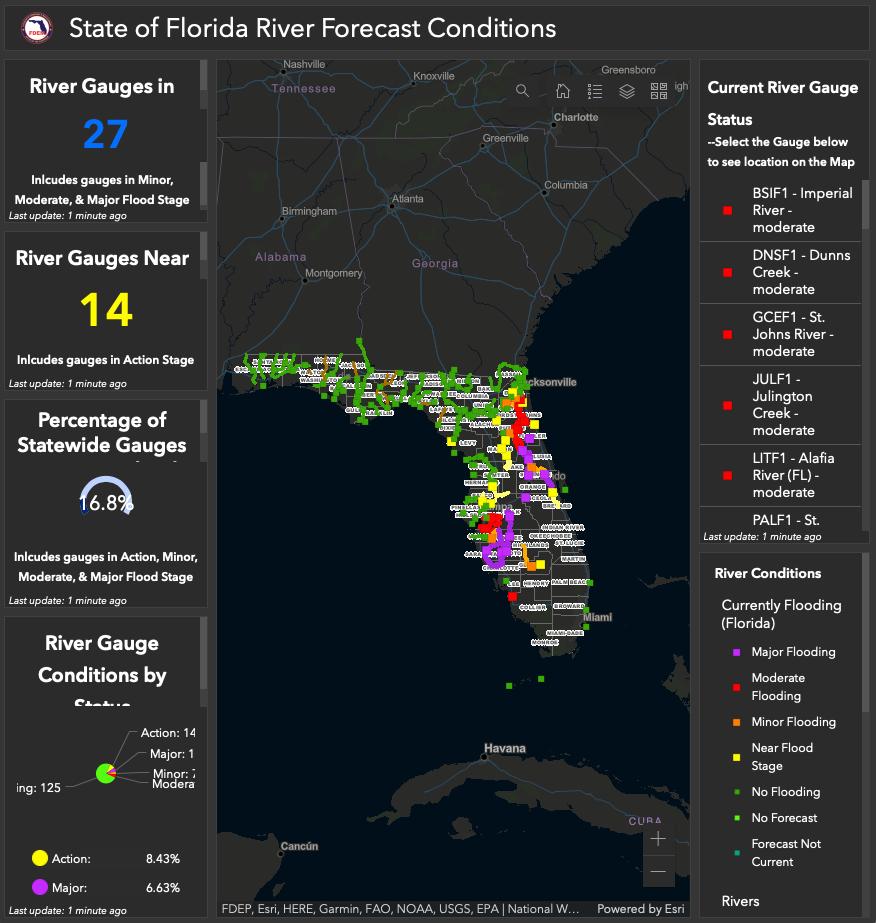
A great use of GIS, here’s a dashboard map of the conditions and flooding of the rivers in Florida from the FDEM Showing the ongoing flooding resulting from Hurricane Ian River Forecast Conditions - Dashboard (arcgis.com)
Richard D. Pryce RLS/PSM | VP Survey & GIS | Craven Thompson & Associates, Inc. rpryce@craventhompson.com
ALL,


Construing Descriptions for Riparian Tracts
DR. RICHARD L. ELGIN, PS, PE
Upland Conveyances, Generally
For nearly all states, on a river navigable for title, the upland’s riparian boundary with the State (owning the riverbed) will be either the ordinary high water line (OHWL) or the ordinary low water line (OLWL). (This article concerns inland nontidal rivers.)
On a nonnavigable stream, the upland’s riparian boundary with the opposite adjoiner will be the thread of the stream. (BTW, exactly where is the “thread of the stream?”) When conveying an upland tract, unless some very explicit, clear indication is expressed otherwise, the instrument will convey all the land the grantor owns … to the OHWL/OLWL or the thread.
For boundary descriptions with phrases like “to the river then along the river,” “all lands north of the river,” “all lands south of the south bank of the river,” “to the bank then along the bank,” “to and with the river,” “to the river’s center,” “to the river thence along its bank” and like phrases, if the grantor owned to the OHWL/OLWL or thread, and barring an unusual exception, the conveyance will be to that line. The presumption is that the grantor conveyed all he or she owned. This includes all of grantor’s lands gained by accretion whether mentioned in the conveyance or not and whether formed by natural or artificial means. All of grantor’s lands will be conveyed, even if the acreage stated is for the uplands and does not include accreted acreage.
The presumption of conveying to the OHWL/OLWL or thread when the deed says “to the bank and along the bank” has been explained by the courts, saying that it is against public policy to create (or leave) small strips (between the bank and the line) in remote grantors. This is particularly true when the strip has no use to the grantor and would benefit the grantee. Leaving a strip between the bank and the OHWL/OLWL or thread of the stream seems illogical. Such a strip, if left in a grantor, would make the grantee’s
The Florida Surveyor Page 9
in The American Surveyor.
*Originally published May 2022

lands nonriparian with no access to the water. Phrases such as “to the river,” calling for a natural monument (the river), in the order of importance of conflicting title elements, trumps all other elements of the description. It extends the call to the center of the monument and as far as the grantor owns. This is also true for artificial monuments such as pins, survey markers, walls, trees and stones. And, applying that the grant is interpreted most strongly against the grantor legal principle, the questionable strip will be conveyed to the grantee.
For a nonnavigable stream, consider the hypothetical: Owner A owns a tract through which the stream flows generally north–south. Owner A conveys to B “all lands west of the river;” then A conveys to C “all lands east of the river.” The boundary between B and C will be the thread of the stream, A does not retain ownership of the streambed.
For a nonnavigable stream, there could be an exception to the presumption that the thread of the stream is the boundary. Consider this hypothetical: Owner A owns a tract through which a nonnavigable stream flows generally north-south. Owner A conveys to B “all lands west of the east bank of the river,” then later A conveys to C “all lands east of the east bank of the river.” (This exact circumstance has been before the Arkansas Supreme Court.) In this example, the thread presumption has been overcome, Junior/Senior rights will prevail: The east “bank” will be the boundary. The bank will be the boundary, but exactly where on the bank is the boundary line?
Another variation on this hypothetical: Owner A conveys to B “all lands west of the east bank of the river,” then later conveys to C “all lands east of the river.” This is a Junior/Senior rights situation. You can’t convey what you don’t own. The boundary will be the bank (with its associated location question). Note that to properly survey C’s land, the surveyor will need the adjoiner B’s deed to check if the deeds “mirror,” there being no gap or overlap.
The Florida Surveyor Page 11
Here there is an overlap, easily discovered and cured.
There may be some reason to exclude a riparian strip from a conveyance of the upland (although it is hard to imagine why). If a grantor wishes to exclude a near–river riparian strip, it would be best practice to write the boundary description such that it includes the strip then excepts it. However, in doing so be aware that the grantee won’t be riparian but that by future erosion the excepted strip may be washed away, making the grantee riparian. Of course, the excepted strip, retained by the grantor will gain land if the stream moves by erosion and accretion “away” from the grantee’s parcel.
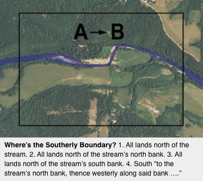
Some Examples, Where's the Southerly Boundary?
Supposing for example, there’s a generally east–west stream that crosses a tract. Here are four examples of different ways lands to the north of the stream could have been described and conveyed. The question is, where is the southerly limit of the lands conveyed using these descriptions. (Let’s assume the stream is nonnavigable for title.)
1. All lands north of the stream.
2. All lands north of the stream’s north bank.
3. All lands north of the stream’s south bank.
4. South along some line “to the stream’s north bank, thence westerly along said bank” to some line, thence northerly … .
Let's look at each of these descriptions
1. All lands north of the stream. For this description, it is highly likely the southerly title line is the thread of the stream, but not a certainty. This “likelihood” needs further title research. If Owner A originally owned the lands on both sides of the stream and then, as the common grantor conveyed “all lands south” then “all lands north” and, through mesne conveyances those descriptions have been used, then, no doubt, the boundary will be the thread of the stream. (But, where exactly, and with specificity is the “thread?” I’ll leave that topic for another article.)
2. All lands north of the stream’s north bank. One may believe the boundary is the north bank, but this may not be correct. This boundary determination will require title research. Suppose Owner A owned both sides of the stream and sold to C “all lands south of the stream” and sold to B “all lands north of the stream.” Then B conveyed to
November 2022 Page 12
D using the description at issue here, “all lands north of the stream’s north bank.” A strict interpretation of these conveyances would result in B retaining ownership of the lands between the stream’s thread and its north bank. Owner D, being conveyed only to the bank, is not riparian. Did he or she really intend to purchase a tract adjacent to a stream that is not riparian? Did B really intend to retain half the streambed?
Applying the court’s reasoning and legal principles previously discussed, Grantor B conveyed all that he or she owned, D would own to the stream’s thread. Owner D’s southerly boundary will be the thread.
1. All land north of the stream’s south bank. This description will require title research. If Owner A originally owned on both sides of the stream and that common grantor first conveyed to B all lands north of the south bank and later conveyed to C all lands south of the south bank, then the south bank will likely be the boundary. Here the question is a Junior/Senior rights question, not a riparian boundary question. From the conveyances, it looks like the grantor knew what he or she was doing. The question will become exactly where, with specificity and repeatability, is the boundary on the “bank” located? And note, C will not be riparian. Through the gradual processes of erosion and accretion, as the stream’s bank moves, so moves the boundary.
2. “To the stream’s north bank, thence westerly along said bank… .” Again, this boundary description will require further title research. Suppose Owner A originally owned the lands on both sides of the stream and conveyed to C “all lands south” and conveyed to B “all lands north.” Then Owner B conveyed to D using the at issue boundary description given above. Under this scenario and for the same reasoning as given in Example 3 above, D’s south boundary would be the thread of the stream (not the bank). The courts have said the presumption is that the grantor conveys all he or she owns. If Owner B owned to the thread, then that person’s grantee was conveyed to that line and not the bank.
Title History Important
In construing boundary descriptions for riparian tracts, in nearly all instances research into the title history will be required. That research will be required back to when an original grantor split the lands, divided by the stream. If, in the original “split,” the description made the boundary the thread of the stream, then by just about any subsequent mesne
The Florida Surveyor Page 13
conveyance descriptions, no matter how described, the riparian boundary will remain the thread of the stream, that being the presumption. Only through some very explicit conveyance or exception will this presumption be overcome.
Caveats and a Suggestion or Two
• Riparian and littoral boundary location can be complex and can be very statespecific. Most states have no statute law pertaining to the boundary description construction issues discussed above. The applicable legal principles will be found in case law. And, as the caveat to every boundary control legal principle warns, the contrary or an exception may be shown. Complicating the location of a riparian boundary is the fact, as illustrated here, the title history (as well as the fluvial geomorphology) will be critical in determining the boundary location.
• Never use the term “bank” when describing a riparian or littoral boundary. The question will be, exactly where, with specificity and repeatability is the boundary located? Will it be the “high bank” or the “low bank” or somewhere in between?
Exactly that question spent the 1920s in the Supreme Court of the United States, the “Red River Litigation” case between Oklahoma and Texas. The central issue in that litigation, the location of the south bank of the Red River is a kerfuffle that continues to this day. (In that litigation the SCOTUS invented the gradient boundary, a term/ boundary location used only on the south bank of the Red River and in Texas.)
• Meander lines are just about without exception never the boundary line for a tract adjoining a waterbody. There are only a very few extreme exceptions to this rule, but that is the subject of a future article. Be very careful when using a meander line in a boundary description of a riparian tract. Actually, using a meander line when describing a riparian tract is probably not best practice. There are better ways to describe riparian tracts without using or describing a meander line. (I’ll leave that topic for another article.)
About the Author
DR. RICHARD L. ELGIN, PS, PE
Dr. Richard Elgin, PS, PE is a surveying practitioner, educator, researcher, collector and author. He codeveloped the “ASTRO” software products and coauthored the Lietz/Sokkia ephemeris. He wrote The U.S. Public Land Survey System for Missouri and Riparian Boundaries for Arkansas and Shoulda Played the Flute (a memoir of his year flying helicopters in Vietnam) and Riparian Boundaries for Missouri (in press). He owns a large collection of early American surveying equipment, rides a Moots bicycle and drives an Alfa Romeo 1600 GT Junior. Dick’s articles have appeared in “American Surveyor” for many years. He may be reached at: elgin1682@gmail.com
November 2022 Page 14

13 Days Over Cuba: The Role of the Intelligence Community in the Cuban Missile Crisis
* Originally Published by the National Geospatial Agency (NGA)
SIXTY YEARS AGO , intelligence professionals across multiple agencies faced one of the gravest crises of the Cold War. It was October 1962, and relations between the United States and the Soviet Union, the two great post–World War II powers, were tense but relatively stable.
The previous year had seen both a failed U.S.–led invasion of Cuba at the Bay of Pigs and, just months later, a Vienna summit between President John F. Kennedy and Soviet Premier Nikita Khrushchev. In the wake of these events, and based on Soviet policy and practice, U.S. intelligence released Special National Intelligence Estimate 85.3.62 on September 19, 1962. The estimate, focused on the question of Soviet military buildup in Cuba, assessed that Premier Khrushchev was unwilling to “ increase the level of risk in U.S.-Soviet relations ” by doing anything so provocative as installing nuclear weapons on the island.
It was in this environment that photo interpreters (PIs) of the recently established National Photographic Interpretation Center (NPIC), an NGA predecessor organization, arrived at the nondescript Steuart Building for work on Monday, October 15. Just before 10 a.m., eight cans of film from the previous day’s U-2 Mission G-3101 were delivered to the NPIC registry and made their routine journey to the seventh floor for analysis. What the PIs discovered that day turned the Intelligence
The Florida Surveyor Page 15
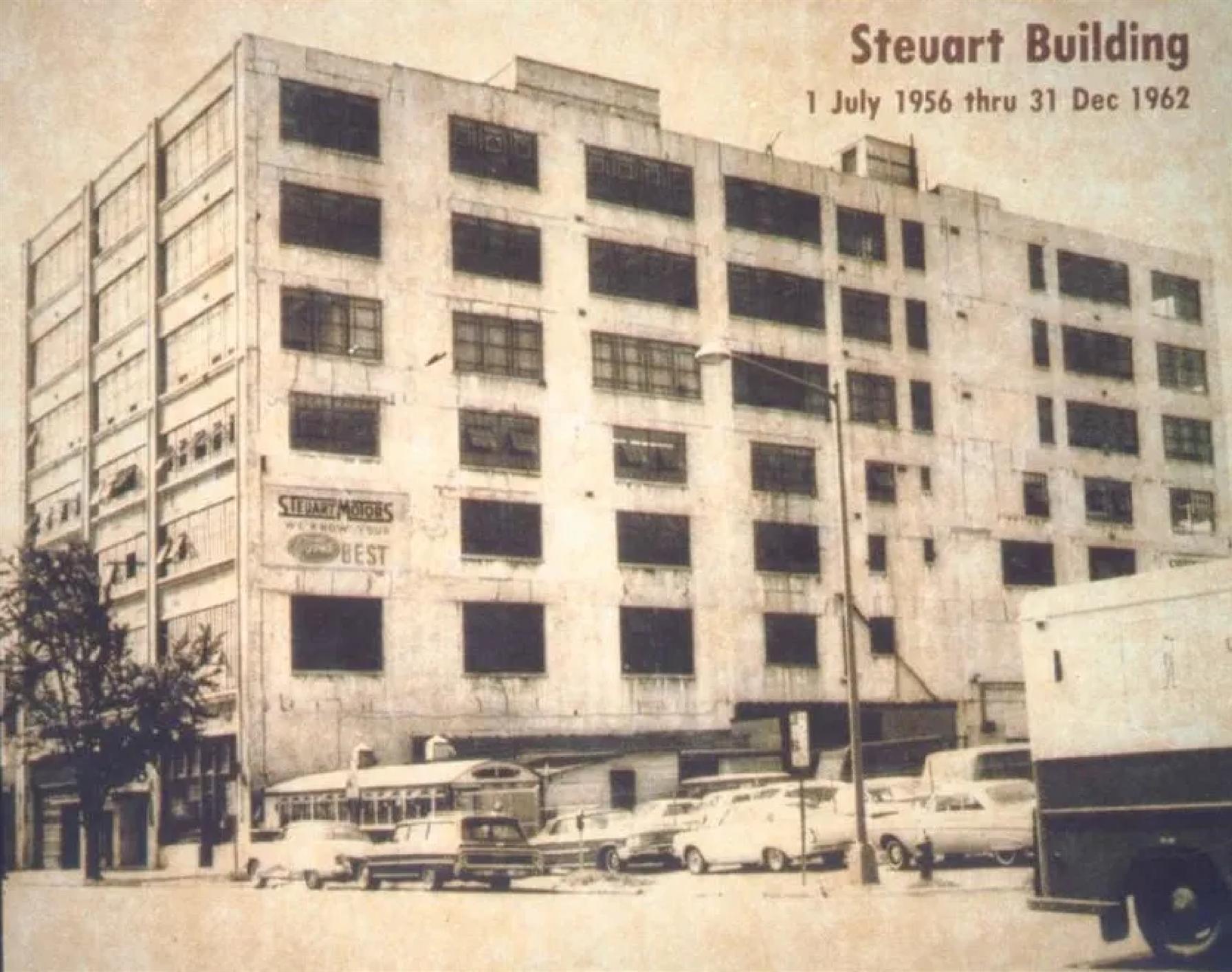
Steuart Building, the first headquarters of the National Photographic Interpretation Center (NPIC) in Washington, D.C.
Community (IC), and the world, upside-down — evidence of Soviet offensive ballistic missiles secretly installed in Cuba with the capability of making a nuclear strike against the continental United States. It was, in the words of NPIC Director Art Lundahl, “ the biggest story ” of their time.
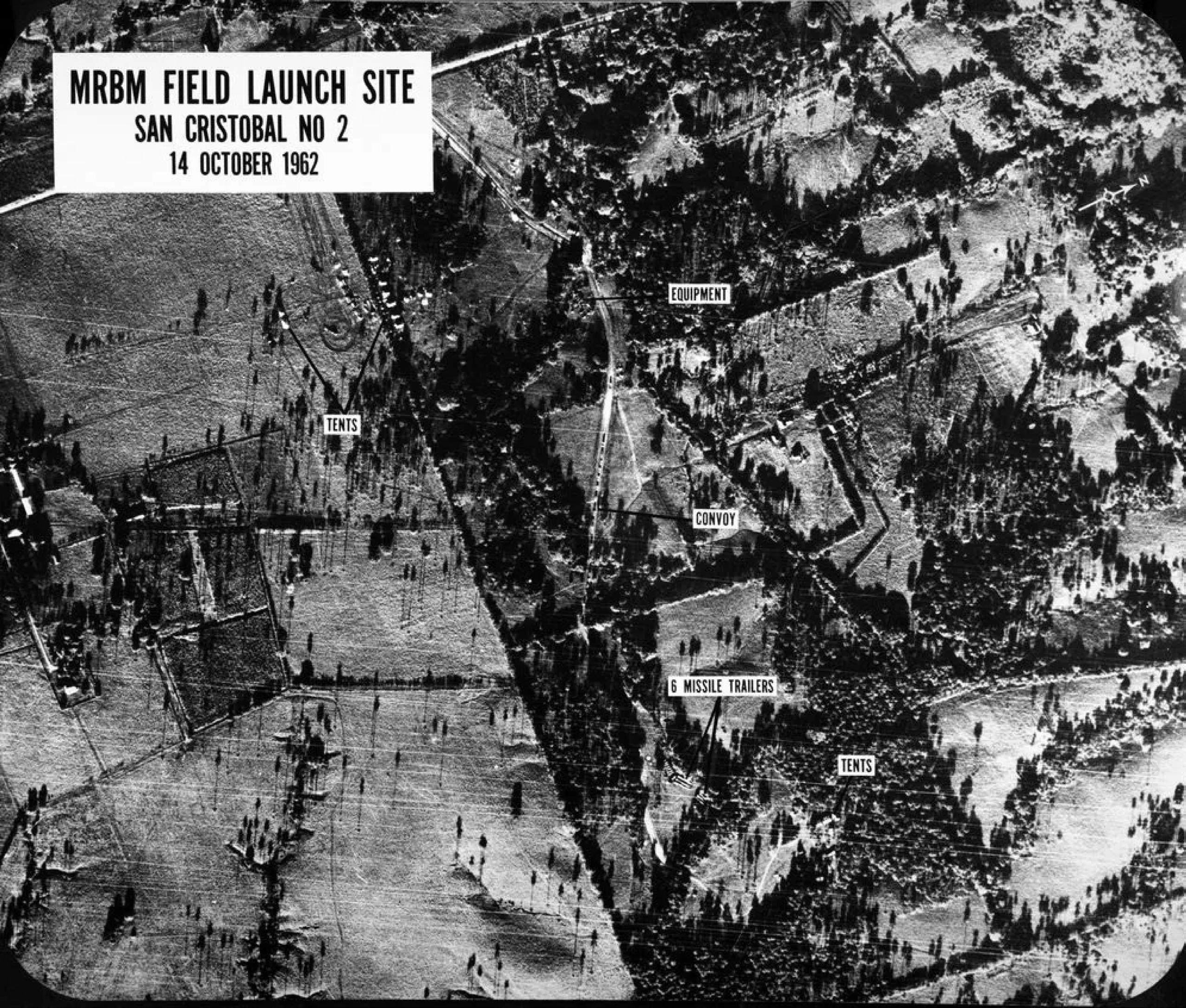
Despite the predominant mindset that the Soviets wouldn’t risk escalation in Cuba, NPIC’s discovery of offensive missiles didn’t happen by luck. For months, across multiple intelligence agencies, there were growing indications that something was happening on the island. From human intelligence sources, including Cuban refugees fleeing the regime of Fidel Castro, the Central Intelligence Agency was gathering reports of suspicious military activities and sightings of advanced weapons. The National Security Agency (NSA), meanwhile, saw a sudden influx in signals intellig ence related to a potential ballistic missile deployment. Many of these indications centered on the region of San Cristóbal, which became the overflight target for Mission G-3101.
Recognizing the stunning nature of its discovery, NPIC utilized an array of sources to identify and confirm the missile sightings. This included IRONBARK sources — the codename given to technical reports and weapons manuals obtained from Soviet spy Oleg Penkovsky — as well as
November 2022 Page 16
Image from the collections of the NGA Historic Research Center.
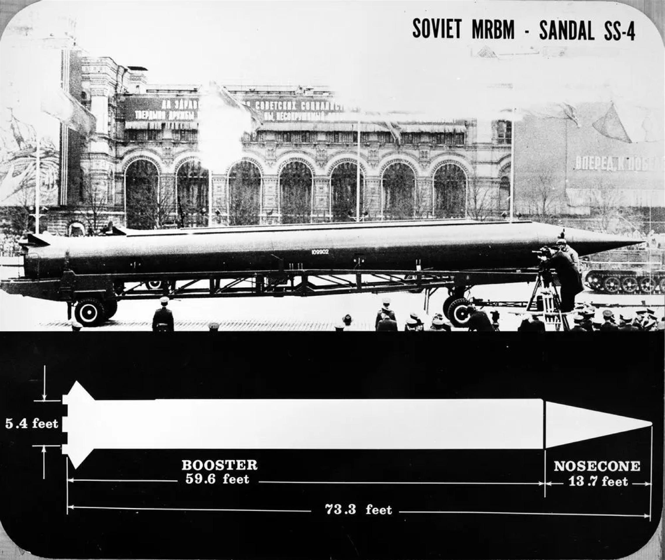
the “ black books ” assembled by NPIC missile specialist Jay Quantrill, which included photos of weapons taken by attachés in Moscow during Soviet military parades. These sources provided detailed design elements and measurements that allowed PIs to confidently identify the Soviet missiles.
Once confirmed, Director Lundahl immediately set in motion a ser ies of late night phone calls and impromptu briefings across the IC and Department of Defense that would ultimately alert President Kennedy to the looming crisis on the morning of Tuesday, October 16.
The Florida Surveyor Page 17
Image from the collections of the NGA Historic Research Center.
The need for timely and accurate intelligence was paramount to U.S. decision-makers in determining the handling of the crisis, with every available intelligence source mined for information. Aerial reconnaissance quickly gained critical importance, providing a means to both visually verify intelligence gleaned from other disciplines and provide concrete photographic evidence of Soviet missiles that could be shared with allies and adversaries around the world, should the need arise. Given its pivotal importance, the decision was made to increase U-2 coverage of Cuba and, eventually, expand surveillance coverage by adding low-altitude flights utilizing both the U.S. Navy F-8U-1P Crusader and the U.S. Air Force RF101C Voodoo. The resulting surge in imagery led to the discovery of multiple
November 2022 Page 18
Photographs taken at Soviet military parades, such as this example of the SS-4 Sandal, aided in the identification and confirmation of missiles in Cuba. Image from the collections of the NGA Historic Research Center.

additional missile sites in Cuba, as well as the existence of S oviet IL-28 Beagle bombers.
At the Defense Intelligence Agency (DIA), the almost daily imagery discoveries occurring at NPIC were used to update target folders in preparation for any necessary military action. At NSA, electronic and signals intelligence supported and expanded the influx of imager y, providing evidence of Soviet military and technical personnel arrivals in Cuba, as well as tracking the all-important question of operational status for the discovered missiles. Taken together, these multiple intelligence sources worked to answer the essential question of time — how long did President
The Florida Surveyor Page 19
Image of the US Navy F-8U-1P Crusader (top) and the US Air Force RF-101C Voodoo (bottom) tasked with low-altitude overflights of Cuba. Image from the collections of the NGA Historic Research Center.

President Kennedy signs Proclamation 3504 authorizing the naval quarantine
Kennedy and his advisors have to respond to the nuclear threat.
Across the IC, agencies worked around-the-clock to provide the knowledge needed to make timely, impactful decisions. NPIC instituted 12-hour shifts, while DIA established a Cuban Situation Room from where its efforts were centrally coordinated. At NSA, the crisis response was overseen from the agency’s firstever command center, run in large part by Juanita Moody, head of the Operations element responsible for signals intelligence in the region encompassing Cuba.
November 2022 Page 20
of Cuba.
Photo by Robert Knudsen, courtesy of the John F. Kennedy Presidential Library / NARA.

U.S.
to the United Nations
a UN Security Council
On October 22, President Kennedy presented the details of the crisis to the American people for the first time, announcing the U.S. intentio n to institute a naval quarantine around Cuba in the effort to stop additional offensive weapons from entering the hemisphere. The quarantine was supported by an array of intelligence sources. PIs at NPIC analyzed photography of ships approaching the island, identifying those that likely carried weapons, while NSA utilized direction-finding nets to determine the course of Soviet ships nearing the quarantine line. NSA also utilized several listening posts — including ground-based stations, aircraft and collection ships — to record and monitor an increasing number of high-priority radio messages between Moscow and ships nearing Cuban waters.
This was followed, on October 25, by the first public, visual presentation of evidence supporting the claims of President Kennedy. Seated across from his Soviet counterpart, U.S. Ambassador Adlai Stevenson presented a series of briefing boards to the United Nations Security Counc il during
The Florida Surveyor Page 21
Ambassador
Adlai Stevenson describing locations of missile sites in Cuba using aerial photographs during
meeting in New York.
Photo courtesy of the Library of Congress, Prints and Photographs Division, NYWT&S Collection LC-USZ62-128472.
a televised session. Utilizing a script prepared by NPIC, the presentation clearly demonstrated the secret Soviet buildup of missiles in Cuba over a two-month period, significantly damaging Soviet public relations. As author DeWitt S. Copp later reflected, “ The UN could not debate away the iron reality of the aerial photographs, nor could the world. ”
Saturday, October 27, considered the longest day of the crisis, began with intelligence indicating that three of the four medium-range ballistic missile sites at San Cristóbal and another two at Sagua la Grande were now operational. This was followed by news from Secretary of Defense Robert McNamara that low-altitude flights over Cuba were now taking fire, followed shortly by news of an even more disturbing incident intercepted from Radio Havana — that a U-2 pilot was shot down and killed over Cuba.
November 2022 Page 22
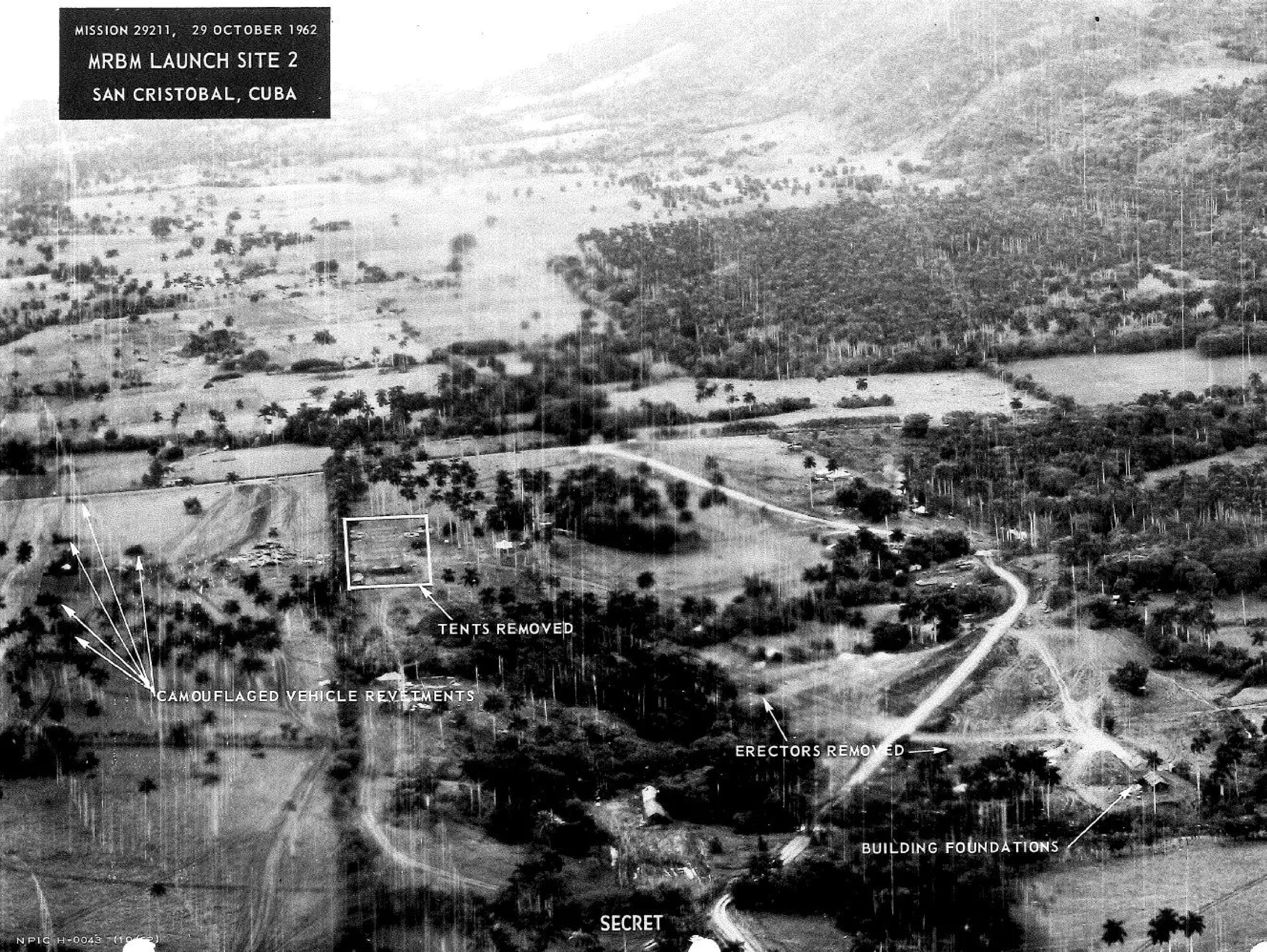
Briefing image showing the removal of missiles and equipment from San Cristóbal, Cuba. Image from the collections of the NGA Historic Research Center.
NPIC photo interpreters Vince DiRenzo, Joe Sullivan, Jim Holmes, and Dick Reninger identified SS-4 Soviet medium-range ballistic missiles (MRBMs) in San Cristóbal, Cuba. Image from the collections of the NGA Historic Research Center.
NSA immediately began sorting through data, even as representatives from the Joint Chiefs of Staff rushed to NPIC to review the flight plan in question against the latest imagery. Within hours, it was confirmed that Major Rudolph Anderson’s U-2 had been brought down by the Los Angeles SA-2 missile site near Banes, Cuba.
That night, expecting the worst, final preparations were instituted across the U.S. for a war that seemed increasingly inevitable. Marine brigades began boarding ships bound for invasion staging areas, thousands of Air Force reservists were told to report to their active-duty stations and U.S. destroyers patrolled Soviet submarines in the Atlantic. At Andrews Air Force Base, transport aircraft were being readied to evacuate casualties that would result from an invasion of Cuba and military hospitals prepared to receive the wounded.
On the morning of Sunday, October 28, the Soviets alerted the U.S. embassy that a formal diplomatic letter was on its way. At 9:09 ET, a brief teletype
The Florida Surveyor Page 23
was received from the Foreign Broadcast Information Service, stating: “ Moscow Domestic Service in Russian at 1404GMT on 28 October, Broadcast a message from Khrushchev to President Kennedy stating that the USSR had decided to dismantle Soviet missiles in Cuba and return them to the Soviet Union 28 October 908a-FRR/HM. ”
Even as word began to spread around the world that the immediate crisis had been averted, the intelligence community was shifting its focus to the work of verifying the dismantling and return of the Cuban missiles to the Soviet Union. Surveillance of missile sites and Soviet ships continued for months after the thirteen crisis days of October, with interest from the press and public remaining high. In February, 1963, John Hughes, Special Assistant to the DIA director, gave a televised briefing to the nation. Closely coordinated with NPIC and utilizing declassified imagery from throughout the crisis, this presentation assured the world that the threat of nuclear missiles in Cuba was truly over.
Hughes could not make public at the time the great debt owed to the intelligence professionals of the Cuban Missile Crisis. Even today, only a handful of names are properly recognized, such as NSA’s Juanita Moody or NPIC’s photo interpreters Vince DiRenzo, Joe Sullivan, Jim Holmes and Dick Reninger.
Sixty years later, as we face a renewed great power competition and threats of nuclear aggression, the Cuban Missile Crisis continues to provide lessons that speak to us today. Then, as now, the ability of the IC to deliver a multiintelligence perspective to decision-makers, providing the advantage in timely, accurate and comprehensive information, can prove critical to resolving crises and averting war.
November 2022 Page 24

Surveyors in Government
November 2022
It has been a two hectic months since I last contributed an article, and what a two months it has been! We have experience a hurricane that many are still working to recover from. Here at the City of Orlando we are doing all of our documentation for FEMA reimbursements and documenting cases of flooding, which includes providing surveying for highwater marks and providing topographic surveys for areas that were damaged from flooding. This includes two roads that either collapsed or that the base and asphalt started coming up, both cases were due to water submersion.
This just shows you never know how you may be impacted from inclement weather, but you try to prepare as best as you can. One way that we prepared was to have our drones charged up and ready to go pre-storm, another was to make sure equipment was accessible and staff was ready to respond when called upon. I was the first to be called in while the sto rm had yet to exit the state to fly our drones over a lake that had overflowed into surrounding roadways, thus cutting off an arterial roadway so we could capture the extent of the flooding.
I was connected to our emergency operations center and our senior leadership, which share pictures of water rescues made by the City’s Water Reclamation airboat staff. They worked with our Fire Department employees to rescue residents who were trapped by flooding and had more than 18” of water in their structures. It is during storm events that surveyors can find themselves doing just anything other than surveying at times. Our survey staff that was called in actually did a combination of surveying and damage tracking to determine blocked roadways, either to fallen trees or to being submerged by water.

The Florida Surveyor Page 25
Surveyors in Government

The ability to provide information on the fly is beneficial for the decision makers and to provide response efforts. I know in Southwest Florida they are still working on disaster response, where we are now focusing on how you address this from happening in the future. One item of note is that in our area this was cited as between a 200-year and 500 year storm event, the amazing thing is that through floodplain management, the effect in most areas was just over a 100 year event in terms of localized flooding. One area has just over 0.2’ above the base flood elevation. For most of the structures affected in this area, they were all pre-firm structures from my understanding We will continue to evaluate the findings and work on approaches to mitigate this in the future, the difficulty is dealing with closed-basins and the lack of elevation to move water from a low lying area and how do you send it to another area without adversely effecting that area.
Sincerely,
Richard Allen, City Surveyor for the City of Orlando
FSMS Surveyors in Government Liaison
407.246.2788 (O)
Richard.Allen@orlando.gov
November 2022 Page 26
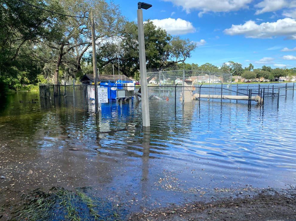
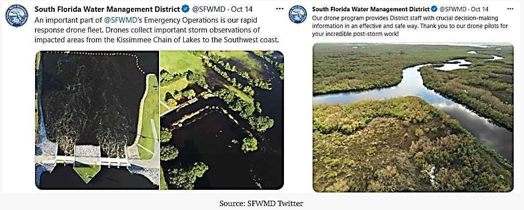
South Florida Water Management District (SFWMD)
Drone/UAS Program, Hurricane IAN Rapid Response.
By: Michael O’Brien PSM, CFM, Survey Section Administrator/UAS Program Mgr.
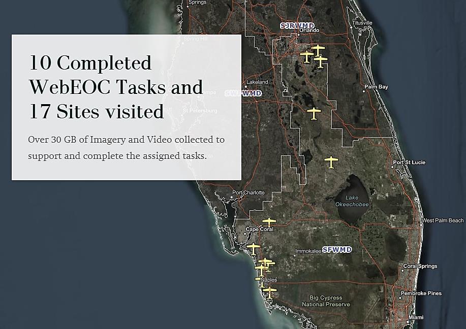
SFWMD’s Drone/UAS Program was developed over the past three -years in response to a growing need for a comprehensive infrastructure utilizing the best UAS tools and resources available, while maintaining compliance with FAA, Florida Statutes Rules, and Regulations. The program is managed by the Surveying Mapping Section , in partnership with GIS/IT.
Services blanket the SFMWD’s entire sixteen-county region, spanning multiple agency divisions and business units. The program has achieved full operational status, with over twenty prequalified pilots, supported by the program’s leadership, fleet of over a dozen drone platforms and mission planning and approval applications.
Challenges:
Hurricane IAN demonstrated live on the job, proof of concept challenges. The program had yet to be tested providing effective Drone/UAS services and product s supporting SFMWD’s Emergency Operations Command (EOC), while under the demands of a State of Emergency.
The EOC Drone/UAS team successfully worked through obstacles such as, identifying and prioritizing primary areas of post-storm flooding, safe travel and logistics, road closures, limited manpower and resources , communication disruptions; all in efforts to deploy missions covering a wide geography, from Southwest Florida to Orlando, and the upper Kissimmee River Chain of Lakes.
Drone/UAS Program Response:
Hurricane IAN was the first event the SFWMD has been able to fully utilize Drone/UAS technology, as the program has just recently matured to a fully functional unit. Primary purpose of the programs resources was to document flood inundation and extents. Our Drone teams were able to field collect, and share critical post-storm video, images and mosaic mapping products, and safely return to headquarters.
Outcomes and Accomplishments:
Throughout Hurricane IAN EOC activation, the Drone/UAS team was able to complete a number of assignments and provide various products, directly supporting EOC operations and the executive office ’s critical decision processes and analysis. Our Drone/UAS teams successfully deployed to hard hit areas effectively and safely, investigating and reporting on existing conditions, in concert with other SFWMD “boots on the ground” teams, supporting public safety, communications, debris removal and high-water mark elevation surveys for SFWMD, FDEM and FEMA analysis and records.
November 2022 Page 28
Celebrating the 50th Anniversary of the Brooks Act
by John Palatiello
On this day, October 27, in 1972, President Nixon signed into law legislation providing for qualifications based selection (QBS) of architecture, engineering, (A&E) and related services, including surveying and mapping. It was 50 years ago today the Brooks Act became law.
At the time of its enactment, the Brooks Act was a radical departure from the norm of lowest b id in Federal procurement. It set a precedent that enabled qualitative factors to become commonplace in various contemporary acquisition procedures. In other words, A&E was for past performance and best value before it was cool.
Enacted by Public Law 92- 582, the Brooks Act was named for its author, then - Representative Jack Brooks (D- TX). Although agencies had used qualifications as an evaluation and selection factor, followed by negotiation of a fee that is “fair and reasonable to the government” for A&E services for more than a century, the legislation was necessary to codify the practice.
“Ask 10 A&E firms to bid on the design of a particular facility and many agencies will take the easy way out and select the low bidder. Under such circumstances, we may end up with a technically capable architect or engineer, but one who, for lack of experience or because of a desire to stay within his bid reduces the time spent on field surveys or in the preparation of detailed drawings, or in providing inspection services. As a result, the government may have saved itself a half of one percent to the cost of construction, operation or maintenance,” said Senator Jennings Randolph (D - WV) on the Senate floor during the 1972 debate on the legislation that became the Brooks Act.
The “qualifications based selection” or “QBS” process is codified for Federal agencies in title 40 of the United States Code, section 1101 and implemented in the Federal Acquisition Regulation (FAR) at 48 CFR 36.6. Passed on a bipartisan basis and supported by lawmakers in both parties over the ensuing 50 years, the process is also recommended by the American Bar Association in its Model Procurement Code for State and Local Government, and has subsequently been adopted by almost every state in a “miniBrooks Act”.
The law emphasizes an investment in quality and competence in A&E services, so the integrity of buildings, facilities and other government activities dependent on designs, drawings, surveys, and other related services could be relied upon during construction , operation, and maintenance over the life of such structures and program activities.
The law requires an agency’s public announcement of its requirements for professional A/E - related services, interested firms compete by submitting their q ualifications, usually on a standard government form, SF 330, the agency evaluates the firms’ submittals and selects a short list of most qualified firms for an interview. Based on evaluations of the firms’ qualifications, experience, past performance and other factors, the agency determines which firm is the most qualified to meet the government’s requirements. The government prepares an independent estimate of the anticipated cost, and a negotiation is held between the government and the selected firm to arrive at a price that is fair and reasonable to the government. In the process, the government holds the cards. If a fair price cannot be negotiated, the government is free to terminate the negotiation and begin discussions with the second ranked firm.
The Florida Surveyor Page 29
It is rare that the United States suffer s from faulty buildings. When such failures do occur, such as the 1978 implosion of the roof of the Hartford Civic Center or the 1981 collapse of the Hyatt Regency Kansas City skywalk, Congress investigated these incid ents and issued a report on “Structural Failures in Public Facilities” in 1984. It found, “procurement practices that lead to or promote the selection of architects and engineers on a low bid basis should be changed to require prequalification of bidders w ith greater consideration given to prior related experience and past performance.” The chairman of the subcommittee conducting the study and publishing the report was then Rep. Al Gore, Jr. (D - TN). As President, Ronald Reagan said at a ceremony recognizing design excellence in Federal buildings said, “Good design doesn’t cost money. Good design saves money, and you know how that warms my heart.”
When earthquakes, hurricanes, and other calamities impact foreign countries, the destruction to buildings too oft en results in tragic loss of life. In America, such instances are rare, due to strong building codes and excellence in A/E services employed through the QBS process. Non - construction related services also benefit from the emphasis on quality. A recent drowning in Loudoun County, Virginia was attributed to inaccurate and incomplete mapping use by the local 911 emergency response system. The Commonwealth of Virginia does not use its state QBS law for this mapping program.
The Brooks Act, licensing of design professionals, and strong building codes contribute to the fact that hurricanes and other natural disasters, while tragic, do not result in the property damage and loss of life in the United States that is experienced in most other countries.
When the landmark Competition in Contracting Act was enacted in 1984 in response to the scandals related to over- priced coffee pots and toilet seats bought by the Pentagon, Congress defined the QBS process as a competitive procedure in Federal law. During consideration of the original Brooks Act in 1972, Senator Edward Gurney (R - FL) explained “any Federal procurement officer … will tell you that competition based on professional- technical qualifications is every bit as hot and demanding as competition based on price, perhaps more so.”
The famous showman, P.T. Barnum, is well known for saying, “There’s a sucker born every minute.” What is less known is that Barnum also observed, “The smartest way of deriving the greatest profit in the long run is to give people as much as possible for their money.” To the nineteenth century British author John Ruskin is attributed the observation, “It’s unwise to pay too much, but it’s worse to pay too little. When you pay too much, you lose a little money that is all. When you pay too little, you sometimes lose everything, because the thing you bought was incapable of doing the thing it was bought to do. The common law of business balance prohibits paying a little and getting a lot — it can’t be done. If you deal with the lowest bidder, i t is well to add something for the risk you run, and if you do that you will have enough to pay for something better.”
The Brooks Act saves money. There is no evidence that selecting architects, engineers, surveyors, or mapping professionals on the basis o f qualifications, competence, experience, and past performance results in higher costs. Indeed, given that such services amount to less than 1/10th of 1 percent of the total life cycle cost of a structure or facility, but affect the operation and maintena nce costs over the life of the facility, the research and data shows the investment in quality in design - related services saves money and human lives. A study conducted jointly by the University of Colorado and Georgia Institute of Technology drew from a database of approximately 200 public and private construction projects in 23 states, including transportation, water, commercial and industrial projects, ranging in size from relatively small projects to those costing hundreds of millions dollars. Its autho rs compared various
November 2022 Page 30
procurement methods, including QBS, best value, and low- bid, with such factors as total project cost, projected life- cycle cost, construction schedule, and project quality outcome. Results showed that using QBS to procure the design component of a construction project “consistently meant lower overall construction costs, reduced change orders, better project results and more highly satisfied owners than in other procurement methods”.
The Brooks Act is a law that has worked for 50 years. It contributes to the public health, safety, and welfare, as well as is part of what makes the United States the envy of the world .
John Palatiello is Administrator of the Council on Federal Procurement of Architectural & Engineering Services (COFPAES), a coalition of leading professional societies and trade associations in the design field and an association executive serving several organizations in the architecture, engineering, surveying , mapping, and geospatial community
Section Leader – Survey
South Florida Water Management District
West Palm Beach, FL
*Work from home flexibility may be available*
Surveying Mapping Section Lead, administrator for a team of discipline specific practitioners ensuring the team's work plans, initiatives, programs, and processes support the agency's core mission of flood control, restoration, and water supply.
Serves as decision maker for the team's day-to-day and long-term operations with minimal supervision. Projects and processes are complex in nature requiring significant decision-making and problem solving. Typically, a team is accountable for a significant amount of the Survey Sections deliverables and financial resources. A team maybe comprised of smaller, functionally related work units with assigned supervisors. Effectively manages internal and external (consultant) survey projects and relationships including usage, costs, and quality of work product, with minimal supervision. Incumbent may represent the Survey Section on District taskforces, inter-agency meetings, or at public forums. May act on the Bureau or Survey Section Administrator or Chief's behalf with all levels of agency executives.
Education/Experience Guide
Bachelor's Degree in a related discipline with a graduate level preferred and 10+ years’ experience that Organization EP8608640 Survey & Mapping Section demonstrates measurable career progression in discipline and leadership roles that can be directly applied to support the District's strategic goals and objectives. Typically, this includes experience in both technical development and 4 years of increased supervisory accountability. Prior experience attained from either internal and/or external jobs.
Licenses:
State of Florida Professional Surveyor & Mapper License required.
Valid State of Florida Driver's License.
Equal Opportunity Employer
The Florida Surveyor Page 31
CLICK HERE TO APPLY


National Spectrum Policy : Interference Issues in the 5G Context
Radio Spectrum as a National Resource
Most wireless technologies, including mobile communications, radionavigation systems (e.g., the Global Positioning System, GPS), radar systems, satellites, and radio and television broadcasting, rely on a range of frequencies of electromagnetic radiation to transmit signals and data. Radio spectrum is the continuum of frequencies allocated for various radiocommunication services.
Spectrum is an invisible, vital, and limited resource for the nation’s economic well-being, security, science, and safety The Code of Federal Regulations specifies frequency allocations between 8.3 kilohertz (kHz) and 275 gigahertz (GHz) This portion of the spectrum i s divided into about 800 bands (or groups of frequencies) for over 30 types of communication services, based on frequency characteristics. Some frequencies can travel long distances and penetrate seawater, making them useful for land -tosubmarine communications. Other frequencies can travel a few miles and penetrate obstacles (e.g., buildings), making them useful for mobile communications.
Radio communication involves the transmission and reception of signals by a radio system. Intended signals may be interfered with by signals transmitted on the same frequency at the same time as well as by spill -over from signals transmitted on adjacent frequencies. Spectrum use is regulated and coordinated to minimize interference and maximize its efficient and productive use
Regulatory Framework for Spectrum
For cross-border radio operations and frequency allocations, the International Telecommunication Union (ITU), an agency of the United Nations, issues a collection of Radio Regulations (RR), an international agreement reached by member nations, including the United States. Nations present and discuss spectrum allocation and use positions at international meetings, including the ITU’s World Radiocommunication Conference that revise s and adopts the RR. Nations also align their domestic regulations with ITU regulations, but may adopt different policies that align with their national interests and priorities
In the United States, the Communications Act of 1934, as amended, assigned joint jurisdiction over spectrum regulation to the Federal Communications Commission (FCC) and the President The FCC regulates nonfederal spectrum use. Commercial entities and state and local governments generally obtain a license from the agency to transmit on an allocated frequency During the licensing process, the FCC’s primary consideration is “whether the public interest, convenience, and necessity will be served.”
The President has the authority to assign frequencies for federal use. Since 1978, this power has been delegated to the National Telecommunications and Information
Administration (NTIA), an agency in the Department of Commerce Federal users must obtain frequency assignments and comply with NTIA regulations and guidance. Its policy priority is to ensure a balance between vital federal operations and commercial use
NTIA has the statutory responsibility to present to the FCC the views of the executive branch on telecommunications. It chairs and receives advice from the Interdepartment Radio Advisory Committee, which consists of representatives of 20 departments and agencies that use spectrum.
Coordination of Spectrum Policy
The FCC and NTIA coordinate spectrum allocations, which are not perpetual and may be reassigned. By statute (47 U.S.C. §922), the agencies must meet regularly to conduct joint spectrum planning. They maintain a memorandum of understanding (MOU) setting terms of coordination. Moreover, a frequency allocated primarily for federal use may be used for nonfederal purposes on a mixed -use basis (subject to conditions) Over 90% of U.S. radio spectrum is shared between federal and nonfederal users. The FCC and NTIA coordinate this sharing to avoid harmful interference and resolve technical, procedural, and policy differences.
Spectrum Repurposing
According to a 2011 Government Accountability Office report, over 60 federal users hold about 240,000 frequency assignments for a variety of purposes, including air navigation and traffic control communications, national defense, land management, and law enforcement. To address the growing demand for spectrum for wireless broadband technologies, including fifth-generation (5G) telecommunications, Congress has directed NTIA to identify federal frequencies that can be reallocated to the FCC for nonfederal or shared use. As of 2020, NTIA and the FCC had made a total of 1,131 megahertz of mid-band (1-10 GHz) spectrum available for commercial 5G services.
Interference Issues
An emission that falls outside its intended frequency and spills over into adjacent frequencies is an out-of-band emission (OOBE) and a major source of interference
Common methods to mitigate OOBE interference are to create a guard band of unused frequencies between the intended and adjacent frequencies and to reduce the power level of transmitters in adjacent frequencies
The FCC and NTIA use the term “harmful interference” as defined in the ITU’s RR. The term indicate s interference at a level that “endangers the functioning of a radionavigation service or of other safety services or seriously degrades, obstructs, or repeatedly interrupts a radiocommunication service.” A challenge addressing potential harmful interference is that users do not always agree on mitigation
The Florida Surveyor Page 33 https://crsreports.congress.gov February 14, 2022
methods and power levels This issue has drawn congressional attention as the FCC has issued licenses for reallocated spectrum, in some instances despite objections by NTIA and affected agencies. Several cases highlighted their competing or even conflicting positions on spectrum.
Weather Satellite Interference
In May 2019, the FCC auctioned licenses for commercial 5G deployment The auction made 2,909 licenses available in the 24 GHz band and raised more than $2 billion Throughout the proceeding, the National Oceanic and Atmospheric Administration and the National Aeronautics and Space Administration raised concerns that 5G services could cause harmful interference to the passive sensors onboard satellites that the agencies operate in the adjacent 23.8 GHz band for weather forecasting and earth science research. Based on technical studies by the agencies, NTIA advocated for more stringent OOBE limits than those adopted by the FCC The ITU later updated its standard with more stringent OOBE limit s in the 24 GHz band, which the FCC subsequently was considering to adopt For more information of the issue, see CRS Report R46416, Forecasting Tropical Cyclones: Overview and Issues for Congress, by Eva Lipiec
GPS Interference
In April 2020, the FCC authorized Ligado Networks LLC to deploy a terrestrial wireless network operating in a segment of the L-band (i.e., 1.5-1.6 GHz). The national security community and GPS equipment makers raised concerns that Ligado’s operatio ns would interfere with GPS signals in the 1559-1610 MHz band. Based on technical analysis by its engineers, the FCC concluded that the conditions in place (e.g., power levels, guard band, and coordination requirements) would protect against interference, promote efficient use of spectrum, and support 5G deployment, and therefore the authorization was “in the public interest.” See CRS In Focus IF11558, Spectrum Interference Issues: Ligado, the L -Band, and GPS , by Jill C. Gallagher, Alyssa K. King, and Clare Y. Cho and CRS Insight IN11400, DOD Concerns About the FCC-Approved Ligado Network, by Kelley M. Sayler and John R. Hoehn
NTIA argued that Ligado’s network would interfere with critical national security and public safety GPS use and that the FCC failed to adequately weigh agency concerns NTIA disagreed with the FCC’s interference evaluation methods, and countered that the FCC should use Department of Transportation (DOT) methods, which found a level of interference high enough to endanger the reliab ility of GPS devices Pursuant to P.L. 116-283, the Department of Defense contracted with the National Academies of Sciences, Engineering, and Medicine (NASEM) to conduct an independent technical review to compare FCC and DOT methods and recommend which most effectively evaluates interference risks to GPS devices. NASEM started the review process in September 2021 and projected the duration of the review to be 15 months.
Aviation Altimeter Interference
Radio altimeters are critical aircraft instrument s that provide precise height-above-terrain/water information. Low altitude operations and flight guidance systems rely on
radio altimeter inputs. Globally, governments and civil aviation use the 4.2-4.4 GHz band exclusively for radio altimeters. The Federal Aviation Administration ( FAA) raised concerns in 2015 that 5G signals transmitted on nearby frequencies could potentially interfere with radio altimeters, particularly if high -powered 5G base stations were placed close to airport runways. In October 2020, RTCA, an aviation technical advisory group, cautioned of likely interference to current generation altimeters from 5G signals in the 3.7-3.98 GHz band. See CRS In Focus IF12028, Aviation Concerns Regarding the Rollout of 5G Wireless Telecommunications Networks, by Bart Elias
In February 2020, the FCC found the OOBE limits it set and the 220 megahertz separation between 5G services in the 3.7-3.98 GHz band and radio altimeter operations in the 4.2-4.4 GHz band should mitigate any significant interference. It concluded a spectrum auction in February 2021, making 5,684 licenses available and raising over $81 billion The FCC asserted the auction was critical for implementing its 5G FAST Plan, which emphases quick mid-band 5G buildout, and fulfilled its mandate under the MOBILE NOW Act (P.L. 115-141, Division P, Title VI) to identify 100 megahertz below 6 GHz for 5G use. In January 2022, 5G carriers agreed to establish buffer zones near airports identified by FAA, where wireless carriers would turn off transmitters for six months while FAA assesses altimeter performance in the 5G environment.
Improving Interagency Coordination
The aforementioned interference disputes have relied on technical studies submitted by interested parties and agencies, which the FCC analyzed before making decisions. Affected agencies contend that the FCC has dismissed their technical findings and their interference concerns.
Congress may consider whether the current interagency process is adequate for identifying potential harmful interference and resolving differences. It may also consider whether the process is effective to balance public and private sector interest s in accelerating 5G deployment with protection of critical national functions. Several bills have been introduced addressing spectrum coordination between the FCC and NTIA. For example, S. 1472, the Improving Spectrum Coordination Act of 2021, would require the agencies to update their MOU periodically and report to Congress annually on joint spectrum planning activities. The update would (1) outline processes for addressing differences in frequency allocation; (2) clarify NTIA’s role in managing federal spectrum use; (3) take into acco unt scientific analyses and implications of spectrum policy in decisionmaking; and (4) ensure the efficient use of frequencies assigned to the federal government and the reallocation of those frequencies not required for federal use to nonfederal users. Another bill, H.R. 2501, the Spectrum Coordination Act, would also require the FCC and NTIA to update the MOU to “improve the process for resolving frequency allocation disputes in shared or adjacent bands ... expeditiously and efficiently.”
Ling Zhu, Analyst in Telecommunications Policy
November 2022 Page 34 National Spectrum Policy: Interference Issues in the 5G Context
https://crsreports.congress.gov
IF12046

The Florida Surveyor Page 35
November 2022 Page 36
The Florida Surveyor Page 37


With the help of Frontier Precision, places you once couldn’t imagine measuring are now a daily reality. Frontier Precision leads the way in Unmanned technology – through the air, land, and underwater. Every place on earth is now reachable – with UAS from DJI, Autel, Parrot, Ascent, and ROVs, Pipe Crawlers, and Utility Crawler solutions from Deep Trekker. Count on us to deliver the latest technology to help you get your job done e ciently and accurately while driving your profits. Today, no mission is out of reach.

LAND WATER
FRONTIER PRECISION | JACKSONVILLE 8301 Cyprus Plaza Drive, #107 Jacksonville, FL 32256 FIND OU T M O RE A T : W W W .FRO N T IE RPRE C IS I ON.CO M / U N M A NN E D P R O DUCTS | T R AINING | RE PAIR | REN TA L S | T ECHNI C A L SE R VICE S
AIR

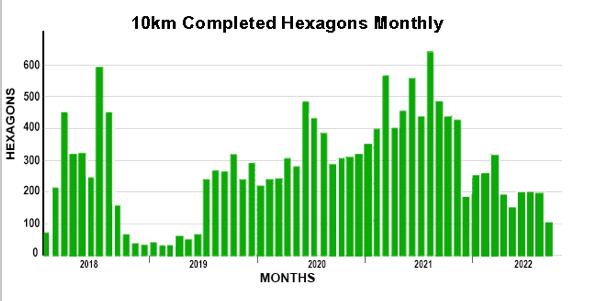
GPSonBM Data for the transformation tool will now be accepted through September 2023
New NSRS Modernization Release Timeline: Mid-2025
NGS will release the data and a limited set of tools for the Modernized NSRS by mid-2025. See the July 2022 edition of the NSRS Modernization News or the June 9th, 2022 NGS Webinar “It’s 2022, Are You Done Yet?” for more information on the revised schedule and what will, and will not, be included in that release.
Given this revised timeline, NGS will keep the doors open for submissions of GPSonBM data for the transformation tools through the end of September 2023. Data submitted before the doors are closed will be considered for use in the 2020.00 Reference Epoch Coordinate (REC) adjustments. Data that passes through the adjustment quality-control process will be used to assign REC coordinates on marks in the Modernized NSRS. Marks with valid coordinates in both NAVD 88 and NAPDG2022 will be used to create the transformation grids that will be released with the modernized system.
Once released, the transformation grids will remain static and the points used will serve as the definitional points in the NAVD88NAPGD2022 transformation. New GPSonBM observations submitted to NGS after September 2023 will have RECs and Survey Epoch Coordinates (SECs) computed in the new frames, however they will not be added into the set of points that define the transformations.
The Florida Surveyor Page 39

Once released, the transformation grids will remain static and the points used will serve as the definitional points in the NAVD88NAPGD2022 transformation. New GPSonBM observations submitted to NGS after September 2023 will have RECs and Survey Epoch Coordinates (SECs) computed in the new frames, however they will not be added into the set of points that define the transformations.
Learn OPUS Projects and Submit GNSS Projects to NGS
Another important decision that NGS announced this summer is the continued development of OPUS Projects to support the Modernized NSRS. This means that investing in learning OPUS Projects now is a tangible action that geospatial professionals and related agencies can take to prepare for working in the Modernized NSRS when it’s released. OPUS Projects 4.0 provides robust functionality to upload and process GPS campaign style surveys, perform adjustments, and submit them to NGS for archiving in the NSRS Database and the creation of official NGS datasheets.
November 2022 Page 40
NGS has released an updated OPUS Projects User Guide and we offer both in-person and online classes , recorded training videos , and other training resources , all for free. Note that to submit your projects to NGS you must start by completing an NGS Survey Project Proposal to get a project tracking number, and you must describe each survey mark by creating description files in the N GS software WinDesc .
We encourage you to participate in the beta testing of OPUS Projects 5.1 , which provides the ability to collect and submit a series of 5 minute observations on marks using Real Time Network (RTN) or Real Time Kinematic (RTK) data instead of the traditional 4+ hour static occupations. This latest version of the NGS flags hip GNSS data processing tool will change the game for surveyors and the broader geospatial community by enabling data submission to NGS and access to the NSRS through much shorter GNSS data collection times. Contact your NGS Regional Geodetic Advisor for more information about training options or planning projects in your area.
The Florida Surveyor Page 41
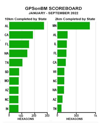
Recent Progress
GPSonBM data submission volumes have remained lower this year than they have been over the past 2 years. However, with another year to go now and new tools to use to collect and submit data, there is plenty of time to make a major impact on the quality of the transformation tool in many communities around the country.
Here’s a shout-out to partners in Alabama who have been consistently filling in data gaps across their state this year. In fact, while the numbers may be down for now, the interest levels and overall GPSonBM chatter seems to be growing. Now that the future of NSRS Modernization is coming into clearer focus, word is getting around that participating in GPSonBM is one very important way that the geospatial community can prepare now to take full advantage of the benefits of the Modernized System when it is released.
November 2022 Page 42
The good news is that we are not concerned about this slow down (yet) because we are banking on the idea that people are starting to plan to collect and submit RTK/RTN data through beta OPUS Projects 5 this year. More on that below…
Take Home Points
• NGS now has a revised schedule to release the Modernized NSRS by mid-2025
• GPSonBM data for the transformation tools will be accepted through September 2023
• NGS will continue to accept GPSonBM and other GNSS data in perpetuity for use in subsequent Reference Epoch Coordinate and Survey Epoch Coordinate computations. (See Blueprint #3 Working in the Modernized NSRS )
• NGS encourages users to learn OPUS Projects and beta test the new workflows for submitting RTK/RTN observations on more marks in less time
The Florida Surveyor Page 43

Why Join FSMS?
LegisLative support –
The Legislative Committee and our Lobbyist are committed to keeping the Public and the Surveying and Mapping Profession protected
educationaL Benefits –
With recently updated courses, getting your CECs has never been better
networking –
Attend our Annual Conference to meet other professionals and meet vendors with all the latest equipment
sociaL Benefits –
Attend local chapter meetings to meet individuals with common professional goals
The Florida Surveyor Page 45 Aug/Sept 2021 30
CLICK HERE TO JOIN! Florida Surveying & Mapping Society 1689 Mahan Center Blvd. Suite A Tallahassee, FL 32308 www.fsms.org (850) 942-1900


• Civil/Site Design
• Construction Engineering
• Construction Materials Engineering & Testing
• Energy
• Environmental, Health, and Safety
• Geotechnical
• MEP
• Structural
• Survey & Geospatial
• Transportation
• Urban Planning & Design
• Water Resources
• Water/Wastewater
PARTNERS FOR WHAT’S POSSIBLE www.pennoni.com Join our Survey
in Florida today!
End of the Biennium is on February 28, 2023!
This is the deadline for License Renewal.
are Required to have Completed at
24
Credit
Need Continuing Education Credits? (Click Here) FSMS Full/Government Members get a Voucher towards any 3 Hour Course of Your Choice. To Claim Your Voucher, Contact our Education Director Samantha Hobbs at education@fsms.org .
Team
The
•
• Licensed Surveyors
least
Continuing Education
Hours.
2022 eLearning Courses
6 General CEC - $99/course (members)
$120/course (non-members)
• Professional Ethics & Professional Courtesy - Course #8363
• Georgia Technical Standards for Property Surveys - Course #8554
• History of Surveying - Course #7140
• Identification of Native & Non-Native Trees in Florida
- Course #8132
• Ethics for the Design Professional - Course #8621
• Land Tenure & Cadastral Systems - Course #8260
• Map Projections & Plane Coordinate Systems - Course #8261
• Mean High Water Observations & Computations - Course #8262
• Public Land Survey System - Course #7147
• Remote Sensing Applications to Surveying & Mapping
- Course #7148
• Practical Geometry for Surveyors
- Course #7141
3 General CEC - $49/course (members) $70/course (non-members)
• Basics of Real Property - Course #8360
• Elevation Certificates & the Community Rating System - Course #8256
• Introduction to Photogrammetry - Course #7968
• Writing Boundary Descriptions - Course #8362
The Florida Surveyor Page 47
Florida Surveying & Mapping Society 1689 Mahan Center Blvd. Suite A Tallahassee, FL 32308 www.fsms.org (850) 942-1900
Florida Surveying and Mapping Continuing Education Provider
Offering 25 Years of Dedication, Quality & Trusted Services
Step 1: Choose Course(s)
3 Hour Courses Available
□ A History of the Prime Meridian Marker,
□ Basics of Real Property
□ Digital Signatures for Surveyors
□ Easements and Rights of Ways,
□ Elevation Cert
□ Introduction to Photogrammet
□ Writing Boundary Descriptions
6 Hour Courses
□ Boundaries in Florida
□ Chapter 177, Platting (Plat Law)
□ Critical Communication for Surveying & Mapping Professionals
□ Ethics for the Design Professional
□ Florida Laws
□ Florida Surveying Law and Rule Changes
□ Geographic Information Systems (GIS)
□ History of Surveying,
□ Identification of Native and Non-Native Trees in Florida
□ Land Tenure and Cadastral Systems

*2020 UPDATED COURSE
□ Quality Assurance/Quality Cont , #9293, 3 CEC
□ Map Projections and Plane Coordinate Systems , #7669, 6 CEC
□ Practical Geometry for Surveyors, #7109, 6 CEC
□ Public Land Survey System, #6979, 6 CEC
□ Remote Sensing Applications to Surveying & Mapping, #6972, 6 CEC *2020
November 2022 Page 48
UPDATED COURSE

The Florida Surveyor Page 49 Step 2: Choose Member Type FSMS Member EMAILED Fee Quantity Amount 6 CEC $115 Per Course x = $ 3 CEC $58 Per Course x = $ MAILED 6 CEC $125 Per Course x = $ 3 CEC $68 Per Course x = $ TOTAL $ Non Non Name: _ YES _ NO Firm: ____ _ YES _ _ NO Address: ______________________________________________________________________________________ City/State: Email Address: Work Phone: Payment Information: ___ Check Enclosed (Payable to FSMS) _ VISA/MasterCard/American Express Card #: _______ Exp. Date: __ CVV Code:___________ Billing Address of Credit Card: ______________________________________ Signature: _____________________________________ __ IF PAYING BY CHECK, MAIL FORM TO: FSMS, P.O. Box 850001-243, Orlando, Florida 32885-0243 IF PAYING BY CREDIT CARD, FAX OR EMAIL FORM TO: 850.877.4852 education@fsms.org QUESTIONS? CALL 800.237.4384 Provider No. CE11 fsms.org


November 2022 Page 50
Find Out More Here
Webb's New View of the Pillars of Creation


H.O. Peters Surveyor of the Year Award
Lou Campanile, Jr.
Board Member of the Year Award
Samuel Thomas Hall
Life Member of the Year Award
Robert B. Strayer Jr.
Fellow Member of the Year Award
Gregory Alan Prather
Committee Chair of the Year Award
Jim Sullivan
Young Surveyor of the Year Award
Shane Alan Christy
Professional Excellence Award
Dr. Amr Abd-Elrahman
Chapter President of the Year Award
Brion D. Yancy
Steven Woods Exceptional Service Award
Richard D. Pryce
Small Chapter of the Year Award
Indian River
Large Chapter of the Year Award
Broward


3002 Surveying 833-352-3002 A Accuright Surveys of Orlando, Inc. 407-894-6314
Barber & Brundage, Inc. 239-597-3111
Engineering & Surveying 239-332-4569 Airworks 857-990-1060
& Company, Inc. 407-654-5355
Engineering 321-783-7443 American Consulting Professionals, LLC. 813-435-2600 American Surveying, Inc. 813-234-0103 Amerritt, Inc. 813-221-5200 Arc Surveying & Mapping, Inc. 904-384-8377 Ardurra, Inc. 239-292-7773 Associated Land Surveying & Mapping, Inc. 407-869-5002 Atlanic Drafting & Surveying 386-264-8490 Avirom & Associates, Inc. 561-392-2594 Axis Geospatial SE, LLC. 410-822-1441 B Banks Engineering 239-939-5490
Ferland and Associates, Inc. 407-896-8608 Barraco & Associates, Inc. 239-461-3170 Bartram Trail Surveying, Inc. 904-284-2224 Bello & Bello Land Surveying Corporation 305-251-9606 Benchmark Surveying & Land Planning, Inc. 850-994-4882 Berntsen International 608-443-2772 Betsy Lindsay, Inc. 772-286-5753 Biscayne Engineering Company, Inc. 305-324-7671 Boatwright and Durden Land Surveyors, Inc. 904-241-8550 Bock & Clark Corporation(NV5) 330-665-4821 Bowman Consulting Group 703-454-1000 Bradshaw-Niles & Associates, Inc. 904-829-2591 Brown & Phillips, Inc. 561-615-3988 BSE Consultants, Inc. 321-725-3674 Buchanan & Harper, Inc. 850-763-7427 C Calvin, Giordano, & Associates 954-921-7781 Carlson Environmental Consultants, PC 561-371-2402 Carter Associates, Inc. 772-562-4191 2022 Sustaining
Agnoli,
AIM
Allen
Allen
Barnes,
Firms Directory
Caulfield & Wheeler
561-392-1991
Chastain-Skillman, Inc.
863-646-1402
CHW Professional Consultants (Causseaux, Hewett & Walpole, Inc.)
352-331-1976
CivilSurv Design Group, Inc.
863-646-4771
Clary & Associates, Inc.
904-260-2703
Clements Surveying, Inc.
941-729-6690
Clymer Farner Barley, Inc.
352-748-3126
Coastal Engineering Associates, Inc.
352-796-9423
Colliers Engineering & Design
732-383-1950
Collins Survey Consulting, LLC.
863-937-9052
Compass Engineering & Surveying, Inc.
727-822-4151
Cousins Surveyors & Associates, Inc.
954-689-7766
CPH Consulting, LLC
407-322-6841
Craven-Thompson & Associates, Inc.
954-739-6400
Cross Surveying, LLC
941-748-8340
Culpepper & Terpening, Inc.
772-464-3537
Cumbey & Fair, Inc.
727-324-1070

D
Dagostino Geospatial, Inc.
239-352-6085
DeGrove Surveyors, Inc.
904-722-0400
Dennis J. Leavy & Associates
561-753-0650
Dewberry
321-354-9729
DMK Associates, Inc.
941-475-6596
Donald W. McIntosh Associates, Inc.
407-644-4068
Donoghue Construction Layout, LLC.
321-248-7979
Douglass, Leavy & Associates, Inc.
954-344-7994
DRMP, Inc.
407-896-0594
DroneView Technologies
248-321-9417
DSW Surveying & Mapping, PLC.
352-735-3796
Duncan-Parnell, Inc.
407-601-5816
Durden Surveying & Mapping, Inc.
904-853-6822 E
Echezabal & Associates, Inc.
813-933-2505
ECHO UES, Inc.
888-778-3246
Eda Consultants, Inc.
352-373-3541
E.F. Gaines Surveying Services, Inc.
239-418-0126
Eiland & Associates, Inc.
904-272-1000
Engineering Group, LLC. 813-386-2101
Group, Inc. 561-655-1151 Engineering Design & Construction, Inc. 772-462-2455
Brownell & Associates, Inc. 305-860-3866
Associates FL, Inc. 813-295-9024
Suryeying & Mapping 904-642-8550
Land Surveyors, Inc. 866-735-1916
Energy Services Inc. 305-213-9969 F Ferguson Land Surveyors 727-230-9606 First Choice Surveying, Inc. 407-951-3425 Florida Design Consultants, Inc. 727-849-7588 Florida Engineering & Surveying, LLC. 941-485-3100 FLT Geosystems 954-763-5300 Fortin, Leavey, Skiles, Inc. 305-653-4493 F.R. Aleman & Associates, Inc. 305-591-8777 Frontier Precision Unmanned 701-222-2030 F.R.S. & Associates, Inc. 561-478-7178 FTE Engineers & Planners 800-639-4851 G Gary Allen Land Surveying 850-877-0541 GCY, Inc. 772-286-8083 GeoData Consultants, Inc 407-732-6965 Geoline Surveying 386-418-0500 Geomatics Corporation 904-824-3086 Geo Networking, Inc. 407-549-5075 GeoPoint Surveying, Inc. 813-248-8888 George F. Young 727-822-4317 GeoSurv, LLC. 877-407-3734 Germaine Surveying, Inc. 863-385-6856 GPI Geospatial, Inc. 407-851-7880 Gustin, Cothern & Tucker, Inc. 850-678-5141 H Haley Ward, Inc. 239-481-1331 Hanson Professional Services, Inc. 217-788-2450 Hanson, Walter & Associates, Inc. 407-847-9433 H.L. Bennett & Associates, Inc. 863-675-8882 Hole Montes, Inc. 239-254-2000 HUB International 850-386-1111 2022 Sustaining
Element
Engenuity
ER
ESP
ETM
Exacta
EXP
Hyatt Survey Services 941-748-4693 I I.F. Rooks & Associates, LLC. 813-752-2113 J John Ibarra & Associates, Inc. 305-262-0400 Johnson, Mirmiran & Thompson, Inc. 813-314-0314 Johnston’s Surveying, Inc. 407-847-2179 K KCI Technologies 954-776-1616 Keith and Associates, Inc. 954-788-3400 Kendrick Land Surveying 863-533-4874 L L&S Diversified, LLC. 407-681-3836 Land Precision Corporation 727-796-2737 Landmark Engineering & Surveying Corporation 813-621-7841 Langan Engineering 973-560-4900 Leading Edge Land Services, Inc. 407-351-6730 Leiter Perez & Associates, Inc. 305-652-5133 Lengemann Corp. 800-342-9238 Leo Mills & Associates 941-722-2460 LiDARit Inc. 407-946-1398 LiDAR USA 256-274-1616 Long Surveying, Inc. 407-330-9717 M Manuel G. Vera & Associates, Inc. 305-221-6210 Marco Surveying & Mapping, LLC. 239-389-0026 Massey-Richards Surveying & Mapping, LLC. 305-853-0066 Masteller, Moler & Taylor, Inc. 772-564-8050 McCain Mills, Inc. 813-752-6478 McKim & Creed, Inc. 919-233-8091 McLaughlin Engineering, Co. 954-763-7611 Metron Surveying and Mapping, LLC. 239-275-8575 Metzger + Willard, Inc. 813-977-6005 Midwest Aerial Photography 614-853-2902 Mills & Associates, Inc. 813-876-5869 Mock Roos & Associates, Inc. 561-683-3113 Moore Bass Consulting, Inc. 850-222-5678 Morris-Depew Associates, Inc. 239-337-3993 Murphy’s Land Surveying 727-347-8740 Firms Directory
N Navigation Electronics, Inc. 337-237-1413 Northwest Surveying, Inc. 813-889-9236 NV5, Inc 407-896-3317 O On The Mark Surveying, LLC. 321-626-6376 Orange orangeuas.com P PEC Surveying & Mapping 407-542-4967 Pennoni Associates, Inc. 863-594-2007 Perret and Associates, Inc 904-805-0030 Pickett & Associates, Inc. 863-533-9095 Platinum Surveying & Mapping, LLC. 863-904-4699 Point Break Surveying 941-378-4797 Polaris Associates, Inc. 727-461-6113 Porter Geographical Positioning & Surveying, Inc. 863-853-1496 Pro-Line Survey Supply, Inc. 904-620-0500 Pulice Land Surveyors, Inc. 954-572-1777 Q Q Grady Minor & Associates, PA 239-947-1144 R Reece & White Land Surveying, Inc. 305-872-1348 Rhodes & Rhodes Land Surveying, Inc. 239-405-8166 Richard P. Clarson & Associates, Inc. 904-396-2623 R.J. Rhodes Engineering, Inc. 941-924-1600 R.M. Barrineau & Associates, Inc. 352-622-3133 Robayna and Associates, Inc. 305-823-9316 S SAM Surveying & Mapping, LLC. 850-385-1179 SCR & Associates NWFL Inc. 850-527-1910 Sergio Redondo & Associates, Inc. 305-378-4443 Settimio Consulting Services 850-341-0507 SGC Engineering, LLC. 407-637-2588 Shah Drotos & Associates, PA 954-943-9433 Shannon Surveying, Inc. 407-774-8372 Sherco, Inc. 863-453-4113 Sliger & Associates 386-761-5385 2022 Sustaining

Southeastern Surveying & Mapping Corp. 407-292-8580 Stephen H. Gibbs Land Surveyors, Inc. 954-923-7666 Stoner Inc. 954-585-0997 Strayer Surveying & Mapping, Inc. 941-497-1290 SurvTech Solutions, Inc. 813-621-4929
T2 UES Inc. 407-587-0603 Tectonic Engineering and Surveying Consultants 800-829-6531 Thurman Roddenberry & Associates 850-962-2538 U Upham, Inc. 386-672-9515 W Wade Surveying, Inc. 352-753-6511 Wallace Surveying Corp. 561-640-4551 Wantman Group, Inc. 561-687-2220 WBQ Design & Engineering, Inc. 407-839-4300 Winningham & Fradley, Inc. 954-771-7440 Woolpert, Inc. 803-214-5928 Z ZNS Engineering, LLC. 941-748-8080 Firms Directory SOCIAL MEDIA LINKS LinkedIn = 240 Followers Facebook = 743 Followers Twitter = 320 Followers Instagram = 144 Followers YouTube
T


ARCHIVES FROM THE


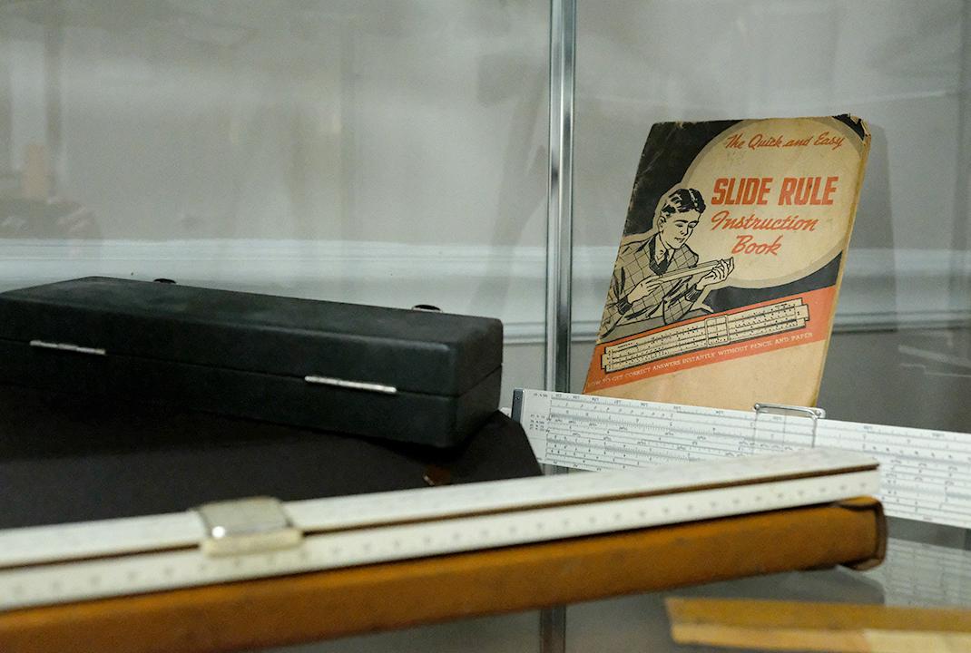
The Florida Surveyor Page 59
The Land Surveyor’s Role in Tomorrow’s Society
by Willis F. Roberts
(Originally published December 1980 in Surveying and Mapping.)
Introduction
Many years ago I was a better than average student of history, but history then was kings and queens, battles, and empires — Little was said about the cultures of the day and even less about the effect of technology on people and about the other influences that shaped people's lives. It is the scientific and cultural history of the past 120 years and its effect on the survey profession that I would like to talk to you about today.
Historical Background
Let us begin around 1850 when the farm predominated and the villages and towns were all established along the rivers and canals because of the convenience of travel and communication. At this time, the surveyor was a professional, well-respected and content working on subdivisions and small engineering projects. The universities were introducing applied sciences and civil engineering which in fact was mainly surveying content. But massive changes were on the horizon; the
iron horse would change the lines of communication, the economy; it would create new towns and centers of commerce, open new lands, and facilitate the exodus of people to the west. These changes all affected the land surveyor.
The surveyor's small comfortable world and its inherent technology was to be shatter ed by railroad construction. It first took the visionaries and adventurers —the cream of the land surveyors—to plan and to initiate, then it took the vast middle majority for the layout of right-of-ways, for estimating cuts and fills, and laying out tangents and curves. The new techniques developed during this time forced the universities to expand their course content drastically to accommodate railway engineering and bridge construction, and, finally, to develop a civil engineering syl labus with the subsequent erosion of the survey content.
November 2022 Page 60
The Land Surveyor’s Role in Tomorrow’s Society
Railroad construction was also characterized by the granting of large tracts of land as railroad subsidies and the granting of lands practically free to desirable settlers, be ginning the exodus from the eastern states to the west. In the east, land values collapsed to the point where the trained surveyor had lit tle inducement to carry on with his profes sion. Thus, the local surveyor in many locali ties became a political appointee, with little training and no professional pride. Consider ing that almost 100 percent of the work was retracement surveys, and that they are the most difficult to execute, it is not surprising that a host of survey problems arise from this period.
The 1880's saw the first polarization of professions. The surveying profession participated in the setting up of USGS (U.S. Geological Survey) in 1879 and their definition of professional staff as geodesists and cartographers. This polarization or vertical grouping within the surveying field was to exert a profound direction on the profession and to last for 80 years before being questioned.
The early 1900's found the people of the New England states again complacent, having reoriented their lives to the railroads; farming still predominated, with new villages and towns along the new lines of communication. The surveyors were largely nonprofessional,
unorganized, existing in a hostile environment, and suffering further loss of curriculum in the universities due to the advent of electricity, but massive events were again on the horizon. The horseless carriage, which over the next 5 decades was again to change the lines of communication, the centers of commerce, and the migration of people to the cities, and then from the cities to suburbia with the construction of highways and superhighways. The economy also went from boom to bust and back to boom because of two major wars, one at the beginning and one at the end of the period.
During this time the surveyor was receiving less and less attention from universities, was only tolerated by the general public, and was even being ignored by polarized groups within his own profession. In addition, he had to withstand the added insult of community planners, farming associations, and then depression, when a bag of potatoes was a good day’s pay. By 1930 the surveyor was faced with extinction.
At the same time another change was on the horizon, or in the air, if you like. The airplane had arrived and its potential with the camera could have had a dramatic effect on the land surveyor, but its use was customized by the cartographer who, in turn, lost the profession to the photogrammetrists. It took 30 years before discussions
The Florida Surveyor Page 61
were even initiated in its application to land surveying with little practical application to date.
The late 1940’s and the 1950’s saw the rebirth of the land surveyor as we know him today, but, remember, it was not due to any effort on the part of the land surveyor, but due rather to external factors and especially the increasing economy. This resulted in a massive housing requirement leading to subdivision work, the bread and butter of the surveyor’s work. No other profession wanted the field work and the land surveyor with poor instrumentation but with hard work succeeded. Few realized the magnitude of the work or the external factors on the horizon which would again affect his profession. This period, through hard work, some money, and selfish pride, gave the surveyor time to form organizations, set standards, be accepted by legislation, and begin policing his own members. His standards were low, but with professionalism in his heart he began to chart his future. I doff my hat to these gentlemen, some of them who are still fighting.
The 1960’s was a decade of massive technological changes. In 20 years a complete instrument change from the compass, transit, and chain to the automated theodolite and EDM equipment with digital display was accomplished. The computer
revolutionized survey computation and then adjustment methodology revolutionized surveying. The setting up of university courses in geodesy, photogrammetry, cartography, and lastly, in cadastre and the subsequent infusion of students from the institutes of technology all helped immeasurably. The land surveying profession grew and accepted new instrumentation, but many of its members lacked the basic knowledge of mathematics and physics to comprehend survey computation and adjustment. This led to their boasting about the “compass rule,” while showing reluctance to attempt continuing education and a lack of knowledge of how to employ university graduates gainfully. This lack of knowledge has temporarily restricted his participation in such fields as satellite positioning and excluded surveyors from exploiting remote sensing and computer technology.
In the 1970’s the land surveyor has strengthened his profession, upgraded his knowledge through continuing education, made contact with universities and seen degree courses being offered, started to overcome the polarization of sciences within the broad field of surveying, and watched the computer science field multiply ten-thousandfold. But, once again on the horizon, major changes are looming that could revolutionize the survey profession or conversely set it back 100 years.
November 2022 Page 62
WILLIS F. ROBERTS
The Land Surveyor’s Role in Tomorrow’s Society
Today
The data bank and, recently, Land Information Systems have been promoted by concerned individuals working within and outside the surveying field. These have been discussed at regional and national meetings under such acronyms as CLIPP, MOLDS, Cadastre, and LII. The first meetings were sponsored by individuals of different organizations with common interest in obtaining better, and in a shorter period of time, information about the land we live on. MOLDS (Modernization of Land Data Systems) is an organization made up of 28 professional associations and federal agencies while LII (Land Information Institute) is made up of 128 members of many allied associations. Both aim to foster education and research, conduct workshops and conferences, and help bring to fruition, in all other feasible ways, improved and compatible land data systems.
Are you making plans to enter this new field? Are you cooperating with your fellow surveyors? Are you integrating with and making your data compatible with the numerous land information projects underway today? Or, are you complacent, like the early easterners, watching the westward migration?
If you are, wake up— for example, electronic engineers may take over with inertial survey systems and position by satellite (PBS).
The same words can be said about cartographers in that the user is unhappy with the long time period of production, the cartographic symbolization, and the artistic display with doubtful credibility. If the cartographers are still complacent, where will they be when thousands of interactive graphic systems are in operation? There are over 100 companies selling interactive graphic systems giving the user within minutes a map at any scale, any projection, and a means of overlaying only the data that the user desires. What about the photogrammetrists, complacent in their ivory towers, highly polarized as a separate profession, when in the eyes of the user, they are becoming only photo interpreters? The photogrammetrist is now crying that the camera is the weakest tool in his box of tricks and not listening to the user who wants his information retrievable by polygons and not models or map sheets.
At first glance our profession in 1980 looks in top shape, but if we move the clock backward and start the sequence with 1980 replacing 1850 and with land information systems replacing the railroad with unknown x, y's replacing the car, etc., could not history repeat itself? It can be seen that the surveyor can attempt to control his destiny by going back over time and superimposing today's capability over the history of the past 100 years on our broad profession.
The Florida Surveyor Page 63
For example, if education were moved back 20, 40, or 60 years, what effect would it have had on our position today?
The second important factor to be gained is that everyone here likely disagrees with the weights I have placed on each discipline and I can only agree with them. Why? Because in the United States and Canada we lack statistical data on which to build the model. [The author illustrated his presentation with slides, showing a series of graphs depicting the history of the profession, overlaying them to emphasize various points.]
Suggestion
The U.S. Bureau of Census working paper No. 5 which summarizes “occupational trends 1900 to 1950” lists surveyors under the heading, ‘Engineering and Science Technicians,’ and table 221 under the same heading projects these lists for the years 1960 and 1970. It is interesting to note that the surveyors are listed under technicians and that no breakdown of disciplines, such as college and university teachers, urban and regional planners, geodesists, etc., within the profession is made.
My first suggestion is that you define and collect statistical data pertaining to your profession and initiate a modeling system to aid in your decision making.
If we accept that the effect of a Land
Information System on our profession will be monstrous, then we must know the monster. A comprehensive definition of a Land Information System is not possible at this time, but in my view certain basic characteristics are surfacing. I would list these as follows:
1. The system will be made up of many data bases or files;
2. Each data base will be housed within one jurisdiction and its specifications must be well defined;
3. All data bases must have a common index file (parcel index);
4. The elements of each data file must be locative positions (coordinates) for data manipulation;
5. An interdisciplinary approach is mandatory, not polarization.
On the other hand, when one considers the components of a Land Information System, the numbers, need, and time factor can easily discourage one from attempting to put together such a system. Even worse, it confuses and magnifies the problem of clear presentation to the decision maker, but I suggest to you that the components can be grouped into basic categories in order or priority as listed below:
1. Positional location and file index.
2. Additional base components.
3. Resource and infrastructure components.
November 2022 Page 64
WILLIS F. ROBERTS

DID YOU KNOW?
In 1908, the Ford Motor Company introduced the “Model T” aka Ford Touring to the world. It was one of the first mass produced automobiles in America and quickly changed the culture.
One of the biggest reasons for its appeal was how well priced it was for many Americans. Ford discontinued the Model T in 1927 after having sold more than 15 million vehicles. Source
The Florida Surveyor Page 65
courtesy of newspapers. com, Alma Record: 1908
For Those Needing Assistance or Would Like to Give a Donation to Those Impacted by Hurricane Ian, FSMS has an Established Disaster Relief Fund.
*The FSMS Disaster Relief Fund is solely funded by member donations and distributed to those in need after a disaster occurs.
A PPLY FOR DISASTER RELIEF
CliCk Here for Disaster Relief Application
(Fill out & email to director@fsms.org)
CliCk Here for NSPS Disaster Relief Application
(Fill out & email to trisha.milburn@nsps.us.com)
*Funds can go towards covering deductibles, storm supplies, minor damages and losses, gas, replenished food, etc.


CliCk Here to Donate Online
The Land Surveyor’s Role in Tomorrow’s Society
My second suggestion is that you define and redefine the basic characteristics of an information system, define the components and method of data presentation, which has been jurisdictionally within your field of endeavor, and add new components which you feel you can support.
One method of solving the problem is through the use of computer technology and computer science. The track record of the computer as the driving mechanism could either be described as frustrating or, if viewed over its short period of application (10 to 15 years), as amazing.
The first attempt was to place masses of data in computer storage and to sort this data according to prearranged indexes. This system worked reasonably well for such projects as census, but it was soon realized the data to be used was costly to collect, was seldom accurate, and quickly became obsolete.
The second approach, commonly known as the “integrated” system, was designed so that the resulting accumulation of data in each component could be interrelated with data from other components and thus used by all. It was soon realized, however, that the configurations of each component tended to vary widely and, further, within each component to vary over fairly short periods or time. This caused
time restraints and costly systems maintenance in an operational mode.
The present trend is to look at each component separately on the premise that they could be integrated when and if necessary; an “integrate-able” system and not an “integrated” one. This, of course, means compatibility between components software. It can be further enhanced by the use of analytical filing and handling of data, thus using the peculiarities of a computer-driven system most efficient for handling massive files and their random access.
In other words, the most effective means of achieving this commonality is by relating the data to the coordinate of the location—the point, line, or polygon. Is it by chance or by conceptual design that computer-generated digital input or output, commonly called interactive graphics, is the same technology? If we use the same coordinate base, a convergence of two initially separate sciences is now possible. The key is the coordinate location.
The workforce in this approach is included within the service sector. Fortunately, the U.S. Bureau of Census, has long maintained a good record of how its workforce has been employed. Agriculture was the name of the game in 1800, with an average of 87 percent of the workers thus employed. The first substantial employment in industry came around 1850 when it comprised
The Florida Surveyor Page 67
about 20 percent of the workforce.
In those years about 16 percent were in the services and that was the only time in American history that industry employed more than service. It is emphasized that we have, for example, not only the computer science field but the largest sector of the workforce in the United States either to compete within or to interrelate and cooperate within our profession.
My third suggestion is that an atmosphere of cooperation with the computer science field be created, stressing the coordinate location capability, and that interdisciplinary efforts in day-by-day project work be continued and encouraged within the service sector.
Lastly, let us look at another cliché being kicked around for the past 10 years: that of the post-industrial society, one where futurists predict that brain work and information handling will predominate, work will be equally accessible to both sexes, public sector involvement will be increased, most workers will be “managers,” and so on. The most important consideration to us is that it will be information–or knowledge-dependent, based oh postgraduate education and skills. Remember, information gives power to those who possess it. It also has other attributes, however: It can be wrong as well as right, adequate or inadequate.
My fourth suggestion is that all of you enter into and strongly support all fields of research and development, and that you actively participate in continuing education, including interdisciplinary courses.
Conclusion
The suggestions I have made for strengthening the surveyors’ future role could be more than just suggestions: They could be considered goals that should be addressed in sequence with a view to moving the profession ahead in a rapidly changing world. Are we leading the procession to the postindustrial society or snoozing at the side of the processional route?
November 2022 Page 68
WILLIS F. ROBERTS
ADMINISTRATIVE Staff


Executive Director
Rebecca Culverson director@fsms.org
Education Director
Samantha Hobbs education@fsms.org
Communications Coordinator
Justin Ortiz communications@fsms.org
Regional Coordinator
Cathy Campanile seminolecc84@gmail.com
The Florida Surveyor Page 69
Past Presidents
1956
H.O. Peters
Harry C. Schwebke
John P. Goggin
R.H. Jones
1960
Hugh A. Binyon
Russell H. DeGrove
Perry C. McGriff
Carl E. Johnson
James A. Thigpenn, III
Harold A. Schuler, Jr.
Shields E. Clark
Maurice E. Berry II
William C. Hart
Frank R. Schilling, Jr.
1970
William V. Keith
James M. King
Broward P. Davis
E.R. (Ed) Brownell
E.W. (Gene) Stoner
Lewis H. Kent
Robert S. Harris
Paul T. O’Hargan
William G. Wallace, Jr.
Robert W. Wigglesworth
1980
Ben P. Blackburn
William B. Thompson, II
John R. Gargis
Robert A. Bannerman
H. Bruce Durden
Buell H. Harper
Jan L. Skipper
Steven M. Woods
Stephen G. Vrabel
W. Lamar Evers
1990
Joseph S. Boggs
Robert L. Graham
Nicholas D. Miller
Loren E. Mercer
Kent Green
Robert D. Cross
Thomas L. Conner
Gordon R. Niles, Jr.
Dennis E. Blankenship
W. Lanier Mathews, II
Jack Breed
2000
Arthur A. Mastronicola
Michael H. Maxwell
John M. Clyatt
David W. Schryver
Stephen M. Gordon
Richard G. Powell
Michael J. Whitling
Robert W. Jackson, Jr.
Pablo Ferrari
Steve Stinson
2010
Dan Ferrans
Jeremiah Slaymaker
Ken Glass
Russell Hyatt
Bill Rowe
Dale Bradshaw
Lou Campanile, Jr.
Bob Strayer, Jr.
Dianne Collins
2020
Don Elder
Hal Peters
Page 70
Please email communications@fsms.org to notify us of upcoming events.

Advertise With Us!
All advertisements contained within the publication are published as a service to readers. Publication of the advertisements does not imply or express any endorsement or recommendation by FSMS.
Benefits: Full color; hyperlinks added to your webpages as well as email addresses.
Requirements: Contracts for one year (11 issues) receive 10% discount if paid in advance; 15% for Sustaining Firms. (Ads should be in jpeg, pdf, or png format)
New ads and/or changes are due by the 25th of each month.
Size 1 Issue 2-11 Issues Full Page $720 $395/issue 1/2 Page $575 $320/issue 1/4 Page $290 $175/issue
