
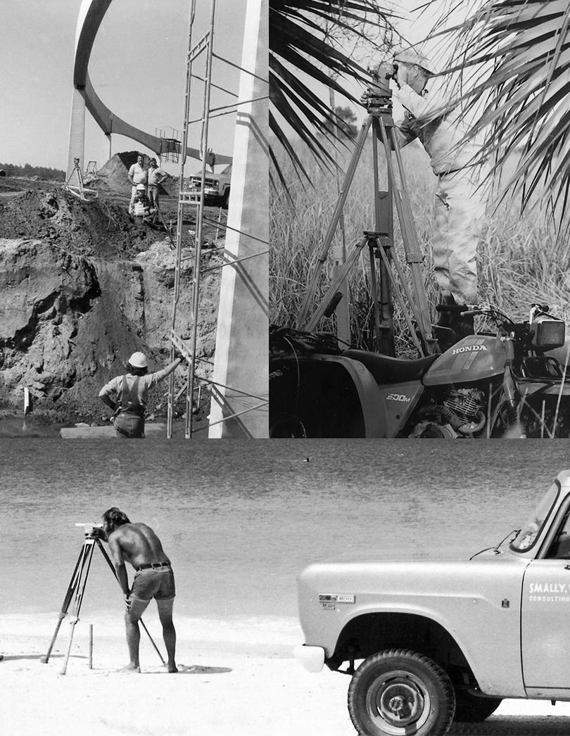
IN THIS ISSUE Searching for Bandy's 1912 Campsite FSMS Pioneer Robin Petzold Ives 1856 Military Map
he
lorida Surveyor March 2023 Volume XXXI, Issue 3
T
F
Increase productivity by combining lidar scanning with robotics
The GTL-1200 combines the power of a robotic total station with a best-inclass laser scanner to perform digital layout and capture high -res 3D scans in a single setup. Simplify the scanning process and dramatically reduce the need for post-processing by capturing scan data on survey control. The workflow seamlessly integrates with ClearEdge3D software for advanced construction QA workflows and as-builts.

• Quick layout and scanning with a single instrument.
• Wi-Fi capability enables point clouds to be transmitted wirelessly
• Proven robotic total station design, integrated with a scanner.

• Full dome scan in seconds, now with 2x point cloud resolution.
• Scan density tailored to minimize software processing time.
• Point clouds accurately matched to BIM model coordinates.
Reduce your modeling time by up to 75%
EdgeWise™ software from ClearEdge3D offers a host of modeling features and tools that help users quickly convert point clouds into usable, as-built 3D plant and building models. The software’s automated feature-extraction capability, pattern-recognition technology and object-recognition algorithms provide you with maximum efficiency. Using these features, the modeling process can be completed in a fraction of the time previously required.
• Increased accuracy and speed when modeling

• Ability to do 3D models of as-built pipes, structural elements, ducts, walls, tees and conduits
• MEP (Mechanical, Engineering and Plumbing), structural and architectural-modeling capabilities
• Billion-point visualization engine with photo-realistic project views
• Fully interoperable with Plant3D, CADWorx, PDMS and Autodesk Revit
43316 State Road 19 Altoona, FL 32702 www.lengemann.us


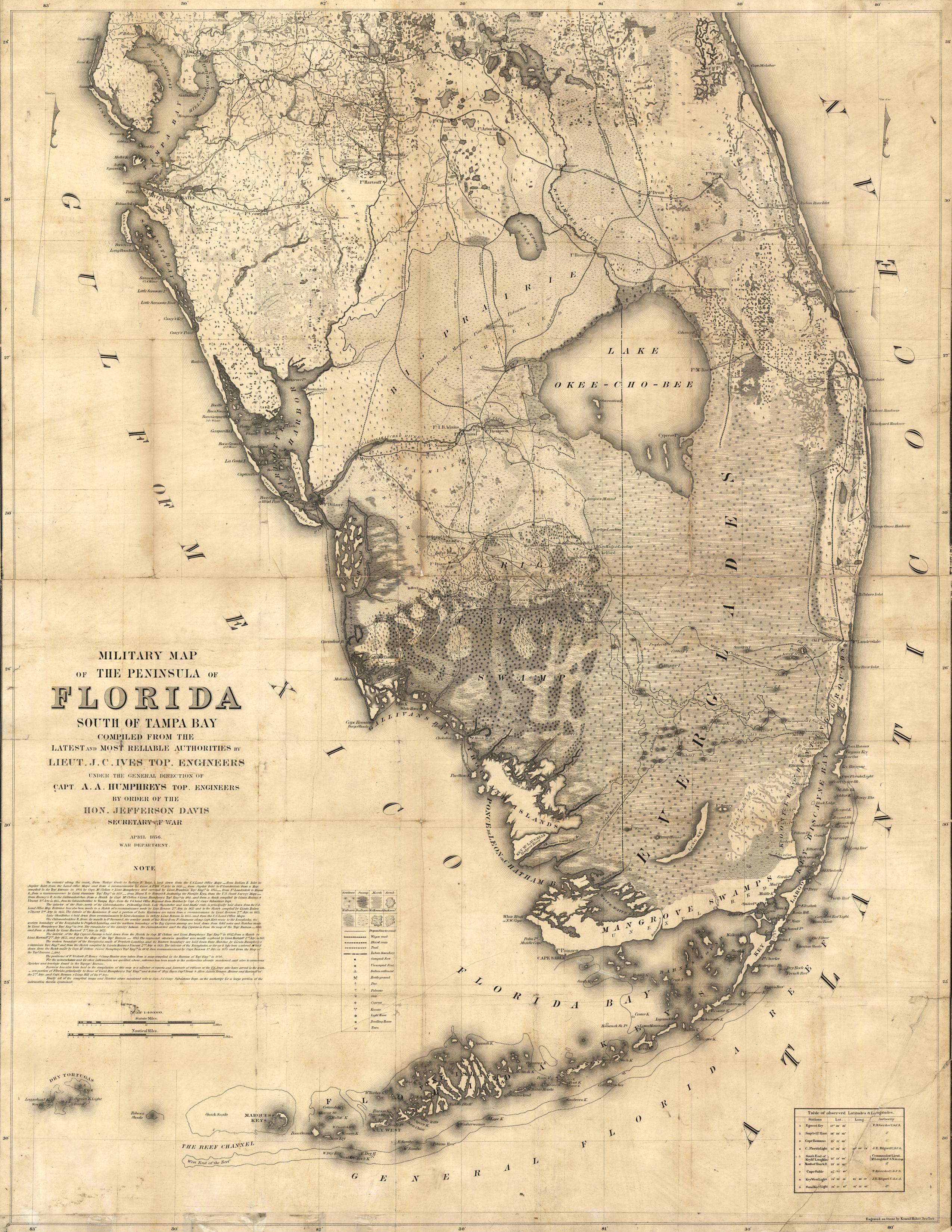
Page 3 CORRESPONDENCE Bandy & Thigpenn III 11 FSMS PIONEER Robin Petzold 7 IVES 1856 MILITARY MAP South of Tampa Bay 49 BREAKFAST ON THE Big Horns W.R. Bandy 17 SEARCHING FOR Bandy's 1912 Campsite 23 2023 SUSTAINING Firms Directory 39 SURVEYORS IN Government 37 AROUND The State FROM THE 45 51 PRESIDENT’S Message 1 2023 FSMS Officers 3 2023 DISTRICTS and Directors 4 The F lorida Surveyor is the official publication of the Florida Surveying and Mapping Society, also known as FSMS. It is published monthly for the purpose of communicating with the professional surveying community and related professions who are members of FSMS. Our award winning publication informs members eleven months out of the year about national, state, and district events and accomplishments, as well as articles relevant to the surveying profession. In addition, continuing educational courses are also available. TABLE OF CONTENTS
PRESIDENT’S Message
I’m sure you’ve read this letter by President Lincoln:
To Mrs. Bixby, Boston, Mass.
Dear Madam,
I have been shown in the files of the War Department a statement of the Adjutant General of Massachusetts that you are the mother of five sons who have died gloriously on the field of battle.
I feel how weak and fruitless must be any word of mine which should attempt to beguile you from the grief of a loss so overwhelming. But I cannot refrain from tendering you the consolation that may be found in the thanks of the republic they died to save. I pray that our Heavenly Father may assuage the anguish of your bereavement and leave you only the cherished memory of the loved and lost, and the solemn pride that must be yours to have laid so costly a sacrifice upon the altar of freedom.
Yours, very sincerely and respectfully,
A. Lincoln
Over the years I’ve seen so many people in our profession that sacrifice their time and money for the advancement of our profession and to keep you informed. This society is here to help the members by informing them and keeping them up to speed with legislative actions, advancements in technology, as well as so many other issues at hand today.

The next time you see an officer of your chapter, I encourage you to thank them for their tireless service.
We are blessed to have a great organization and great volunteers to fuel it. An
The Florida Surveyor Page 1
President Howard Ehmke (561) 360-8883 Howard@GCYinc.com
PRESIDENT’S Message
organization is only as strong as its membership and volunteers.
Again, I would like to promote the 2023 FIG (International Federation of Surveyors, Fédération Internationale des Géomètres Internationale Vereiningung der Vermessungsingenieure) working week which will be held in Orlando, Florida. It was established in 1878 by seven national member associations. The mission of FIG is to ensure that the disciplines of surveying and all who practice them meet the needs of the markets and communities they serve. FIG aims at addressing land issues at the global level. They cover 120 counties and represent more than 300,000 members. They consider surveying in a much broader spectrum than we do in the states.
We need to be informed about the legislation regarding our profession in the political world. I’ve asked Jack Breed to add a section in The Florida Surveyor to keep you informed. We need to keep ahead of the political machine and the best way to do that is with your donations to the PAC fund . The old Fram oil filter commercial said, “ You can pay a small amount for a good oil filter now, or, if you don't, you'll pay much more later when your car breaks down. ”
March 2023 Page 2


The Florida Surveyor Page 3 President-Elect Richard Pryce (954) 739-6400 rdpryce@gmail.com Vice President Allen Nobles (561) 687-2220 allen.nobles@sam.biz Secretary Sam Hall (352) 408-6033 surveysam17@outlook.com Treasurer Bon Dewitt (352) 392-6010 bon@ufl.edu Immediate Past President Lou Campanile, Jr. (954) 980-8888 lou@campanile.net 2023 FSMS Officers
2023 Districts and Directors
District 1 - Northwest
Bay, Calhoun, Escambia, Franklin, Gadsden, Gulf, Holmes, Jackson, Jefferson, Leon, Liberty, Madison, Okaloosa, Santa Rosa, Taylor, Wakulla, Walton, Washington
Eric Stuart (850) 685-1149
eric.stuart@sam.biz
Chad Thurner (850) 200-2441 chad.thurner@sam.biz
District 2 - Northeast
Alachua, Baker, Bradford, Clay, Columbia, Dixie, Duval, Gilchrist, Hamilton, Lafayette, Levy, Marion, Nassau, Putnam, Suwannee, St. Johns, Union
Nick Digruttolo (863) 344-2330
ndigruttolo@pickettusa.com
Randy Tompkins (904) 755-4235
randytompkins1@ outlook.com
District 3 - East Central
Brevard, Flagler, Indian River, Lake, Okeechobee, Orange, Osceola, Seminole, Martin, St. Lucie, Volusia

Al Quickel (407) 567-1566
alq.fsms@gmail.com
3 4 7 6 5
District 5 - Southwest
Charlotte, Collier, DeSoto, Glades, Hardee, Hendry, Highlands, Lee, Manatee, Sarasota
Shane Christy (941) 840-2809
schristy@georgefyoung.com
Donald Stouten (239) 281-0410 dstouten@ ardurra.com
District 6 - Southeast
Broward, Palm Beach
Mark Sowers (954) 868-7172 msowers@mgvera.com
Robert Johnson (772) 562-4191
bobj@carterassoc.com
District 4 - West Central
Citrus, Hernando, Hillsborough, Pasco, Pinellas, Polk, Sumter
Greg Prather (863) 533-9095
gprather@pickettusa.com
Alex Parnes (813) 493-3952
alexwolfeparnes @gmail.com
Earl Soeder (407) 601-5816 earl.soeder@ duncan-parnell.com
District 7 - South
Miami-Dade, Monroe
Jose Sanfiel (305) 351-2942 psm5636@gmail.com
Manny Vera, Jr. (305) 221-6210 mverajr@mgvera.com
Russell Hyatt (941) 748-4693
russell@hyattsurvey.com
1
2
Director
NSPS
District 1
Panhandle
Bill Butler wtb@butlersurveying.com
Gulf Coast
Jonathan Gibson jgibson0102@gmail.com
Chipola
Jesse Snelgrove jsnelgrove@ snelgrovesurveying.com
Northwest FL
Jeremiah Slaymaker jslay@wginc.com
District 2
FL Crown
Brandon Robbins brndrbbns@netscape.net
North Central FL
Jeremy D. Hallick jdhallick@hotmail.com
UF Ge omatics
Andrea Slaven
aslaven@ufl.edu
2023 Chapter Presidents
District 3
Central FL
William (Bill) Rowe browe@southeasternsurveying.com
Indian River Brion Yancy brionyancy@gmail.com
Volusia Je ff Cory (Interim) jeff@corysurveyor.com
District 5
Charlotte Harbor
Derek Miller millersurveying@comcast.net
Collier-Lee
Steve Shawles II sshawles@haleyward.com
Manasota
Shane Christy schristy@georgefyoung.com
District 6
Broward
Benjamin Hoyle
benjamin.hoyle@kci.com
District 4
Ridge
Kenneth Glass kglass@civilsurv.com
Tampa Bay John Beland
jbeland1979@gmail.com
Palm Beach
Lee Powers
lpowers@zemangroup.com
FAU Geomatics
Brett Costanza brettcostanza@hotmail.com
District 7
Miami-Dade
Frank Paruas
fparuas@gpinet.com
Standing Committees
Nominating Committee
Membership Committee
Finance Committee
Executive Committee
Education Committee
Annual Meeting Committee
Legal Committee
Strategic Planning Committee
Ethics Committee
Legislative Committee
Surveying & Mapping Council
Constitution & Resolution Advisory Committee
Rick Pryce
Nick DiGruttolo
Bon Dewitt
Howard Ehmke
Greg Prather
Allen Nobles
Jack Breed
Rick Pryce
Shane Christy
Jack Breed
Randy Tompkins
Eric Stuart
Special Committees
Equipment Theft
Awards Committee
UF Alumni Recruiting Committee
Professional Practice Committee
Workforce Development Committee
Liaisons
Manny Vera, Jr.
Lou Campanile, Jr.
Russell Hyatt
Lou Campanile, Jr.
Allen Nobles
CST Program
Alex Jenkins
FDACS BPSM Don Elder
Surveyors in Government
Academic Advisory UF
FES
Richard Allen
Bon Dewitt
Lou Campanile, Jr. Practice Sections
Geospatial Users Group
Soeder
Earl
2023 Committees
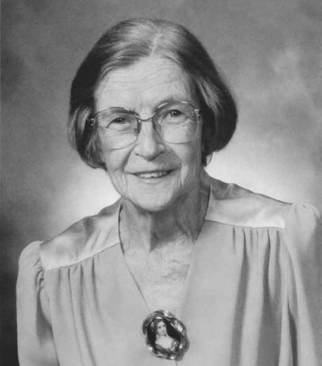
Robin Petzold, PSM 4567, was born on May 11, 1953, in Passaic, New Jersey. He grew up in Ringwood, New Jersey where he graduated with the Class of 1971 at Lakeland Regional High School. After graduation, Mr. Robin attended Fairleigh Dickenson University and achieved an Associate degree in Business Administration. Early in his life, Robin had an interest in helping and working with animals. This led him to pursue a Bachelor of Science degree in Animal Science. Robin is married to his wife, Susan, and he has two children, Kristen and Joshua, along with one brother, Harold, and one sister, Lynn. He also has a nephew who is a Party Chief for Moorhead Engineering in Ocala, Florida.
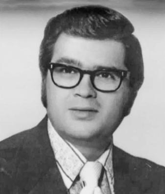
Robin returned to school at Palm Beach Junior College in 1981 to Robin
The Florida Surveyor Page 7
Petzold, PSM 4567
obtain a degree in Surveying and Mapping. While attending PBJC and working full time, Robin served as an adjunct faculty instructor at Palm Beach State College (PBSC) in the Surveying Program from 1982 to 1994, teaching project layout, basic surveying, route geomatics, and measurement science.
Robin retired after forty years of surveying in the profession. He was a senior partner with the firm of Wantman Group, Inc. (WGI) headquartered in West Palm Beach, Florida, with offices located throughout Florida and later other states throughout the country. In addition, Robin served on the Board of Professional Surveyors and Mappers (BPSM) from 2010 to 2018 and continued to serve on the Probable Cause Panel as a past Board member for three additional years. Robin continues to serve on the National Council of Examiners for Engineering and Surveying (NCEES) and has served on the EPS committee, but has served on several others committees throughout his career, including the Surveying Task Force, PAKS, Education, and National Surveying Award. Robin was also a recipient of the 2021 Distinguished Service Award by the NCEES and holds surveying licenses in Florida, Alabama, Ohio, Iowa, and Wisconsin.
When asked how he originally got into surveying, Robin answers, “my strong points were always in mathematics, and with concerns about my future in the world of exotic animals, I chose to return to college and pursue a career in surveying and mapping. I enrolled in Palm Beach Junior College. I secured a job as a rodman with then Wantman and Associates, Inc. in February of 1981 and began my surveying career. I spent several months as a rodman before moving up to instrument operator and another 3 years before becoming a Chief. I moved into the office in March of 1984 and by 1987 I was running 14 field crews on a variety of different projects.”
In July of 1988, Petzold received his professional surveyor’s license and was forever known as PSM 4567 amongst his peers. His first surveying job was a land development project called Sherwood Lakes south of Lake Worth Road in Palm Beach County. He recalls having many varied responsibilities including vertical construction, roadway construction, and numerous boundary surveys. Some of the most prominent survey projects he was a part of include: the Jamaican North Coast Highway(267 kilometers, GPS control, and 338 stations in 1993), Kuwait airbases(Salam and Jaber, GPS controls, cost estimating and site planning), Everglades National Park, “Hole in the Donut” 11 years of topographic control, and River of Grass(SFWMD) 100,087 acres of boundary surveys. The surveying firms he has worked for throughout his career are Meridian Surveying & Mapping(which became Stanley Wantman and later Stanley Consultants), Mock Roos & Associates, and started Petzold & Associates(merging with Wantman Group, Inc. in 2000).
March 2023 Page 8
Mr. Robin’s favorite thing about surveying is all the technology involved, along with the mathematical principles and applications used when operating within the profession, as well as the diversity in the day-to-day assignments, activities, and responsibilities. When asked what his least favorite aspect of surveying is, Mr. Robin responds with, “the lack of respect from the engineering profession and contractors. You prove yourself on difficult projects to gain that respect, but there are still those in the profession that give the profession a bad name. This is one of the reasons that I chose to serve on the DACS Board.” Gaining respect from new clients has also been a challenge at times throughout his career, and he believes more professionalism throughout the industry is a much-needed change for modern surveyors and mappers.
Petzold’s favorite types of surveys are horizontal and vertical control projects. When asked what has changed the most about surveying during his time in the field, Petzold replies, “ WOW! I started surveying when we had tape and transit and if lucky a part-time EDM. I finished with GNNS, Hydrographic, Laser Scanning, Mobile Scanning, subsurface utilities, ground penetrating radar, and Drone technology to name a few. That sums it up. It was the Electronic Era. ” As far as if he had any mentors that influenced him, Petzold lists Carl Purtz at Palm Beach State College, Drs. David Gibson and Bon DeWitt at UF, and James Collins at GPS services in Rockville, Maryland. What has surprised him the most during his time surveying in the profession has been the reluctance of some firms to adapt to the evolution of technology and be willing to embrace it.
When asked if he has a favorite memory from his time in the field surveying, Robin answers, “ By 1987 I began to see the transition to the electronic generation of surveying. This began with the Global Positioning System which led to hydrographic, Laser scanning, Lidar, Drones, etc. Realizing that this was the future, I jumped into this arena at an early age and did my first GPS survey in January of 1990 on the south Kissimmee Chain of Lakes for the South Florida Water Management District. This led to many exciting projects throughout my career. I was registered in 5 states by the end of my career. If there was some advice I could give surveyors, it would be education, education, education. When combined with practical experience you will excel in the profession now and into the future. As many are aware, I taught as an adjunct for 12 years at what is now Palm Beach State College, I taught seminars in the mathematical arena to what is today many of the business owners, I finished my career as an adjunct at UF stepping down only last year. Education and practical experience are the keys to success. ”
The Florida Surveyor Page 9

National Surveyors Week March 19 - 25, 2023 send County/City/State Proclamations to communications@fsms.org
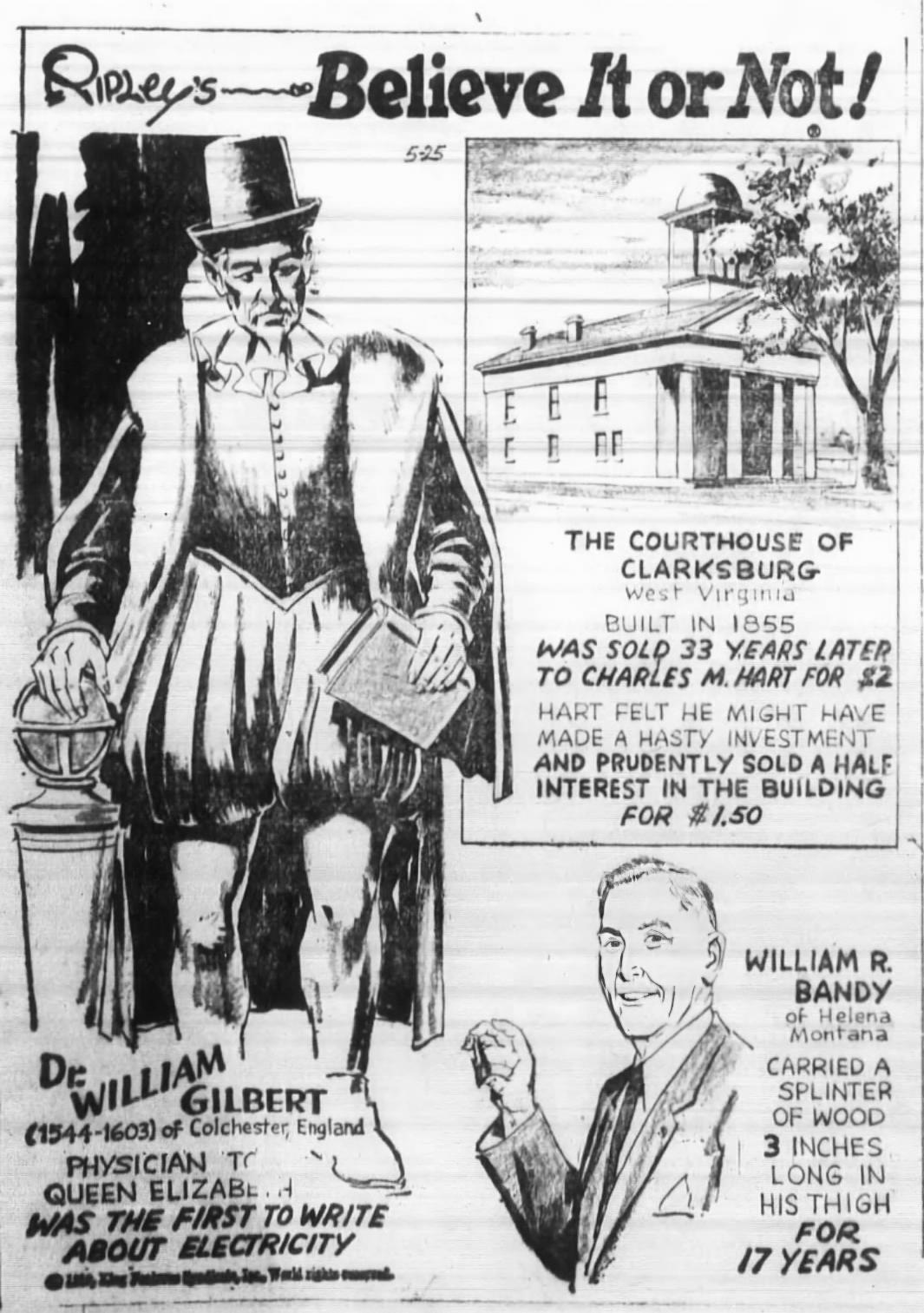
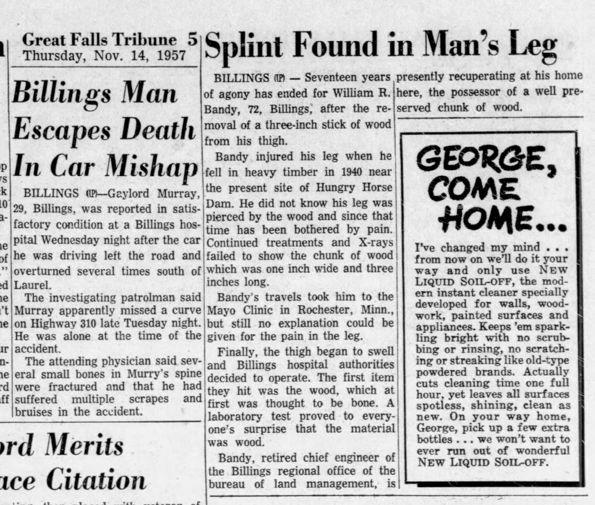
Breakfast on the Big Horns
Shout Out and Special Thank You to Mr. Glenn Borkenhagen and his colleagues. Thank you Mr. Glenn for your diligence and passion in gathering these Bandy artifacts. CLICK HERE for a link to his website where he has archived many of his findings.
by W.R. Bandy
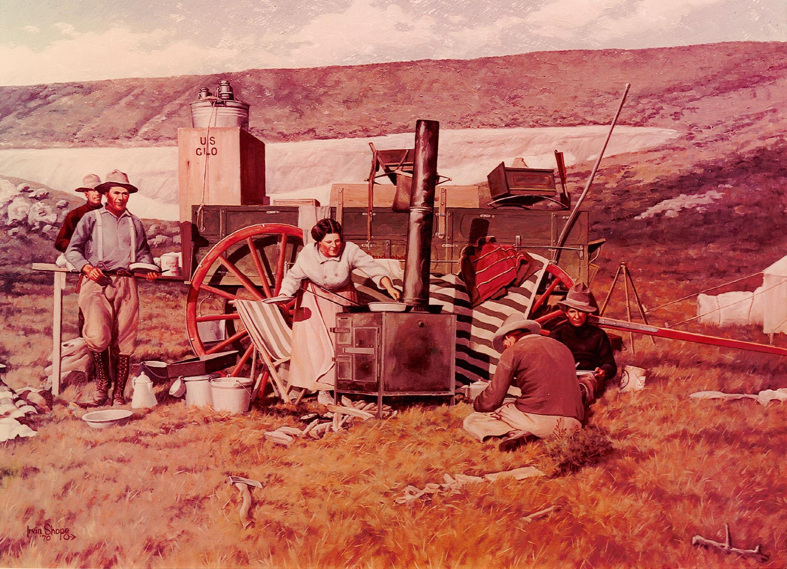
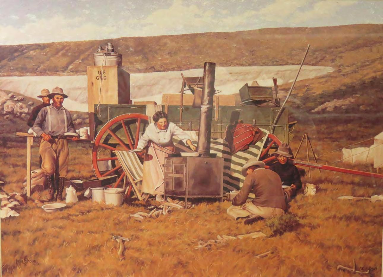
 By Artist Irvin (Shorty) Shope of Helena, Montana
From April 1972: A painting of a survey crew near the Big Horn Mountains in northern Wyoming in 1912. In 1972, former FSMS President James A. Thigpenn III was in correspondence with William Roy Bandy, a surveyor in Montana. Bandy was sending Mr. Thigpenn letters that detailed his life story and included this painting of the campsite. Bandy is second from the left in the painting; behind him is his brother, Willis, and the woman is Bandy’s wife, Inez. The other two men are unidentified survey-aids.
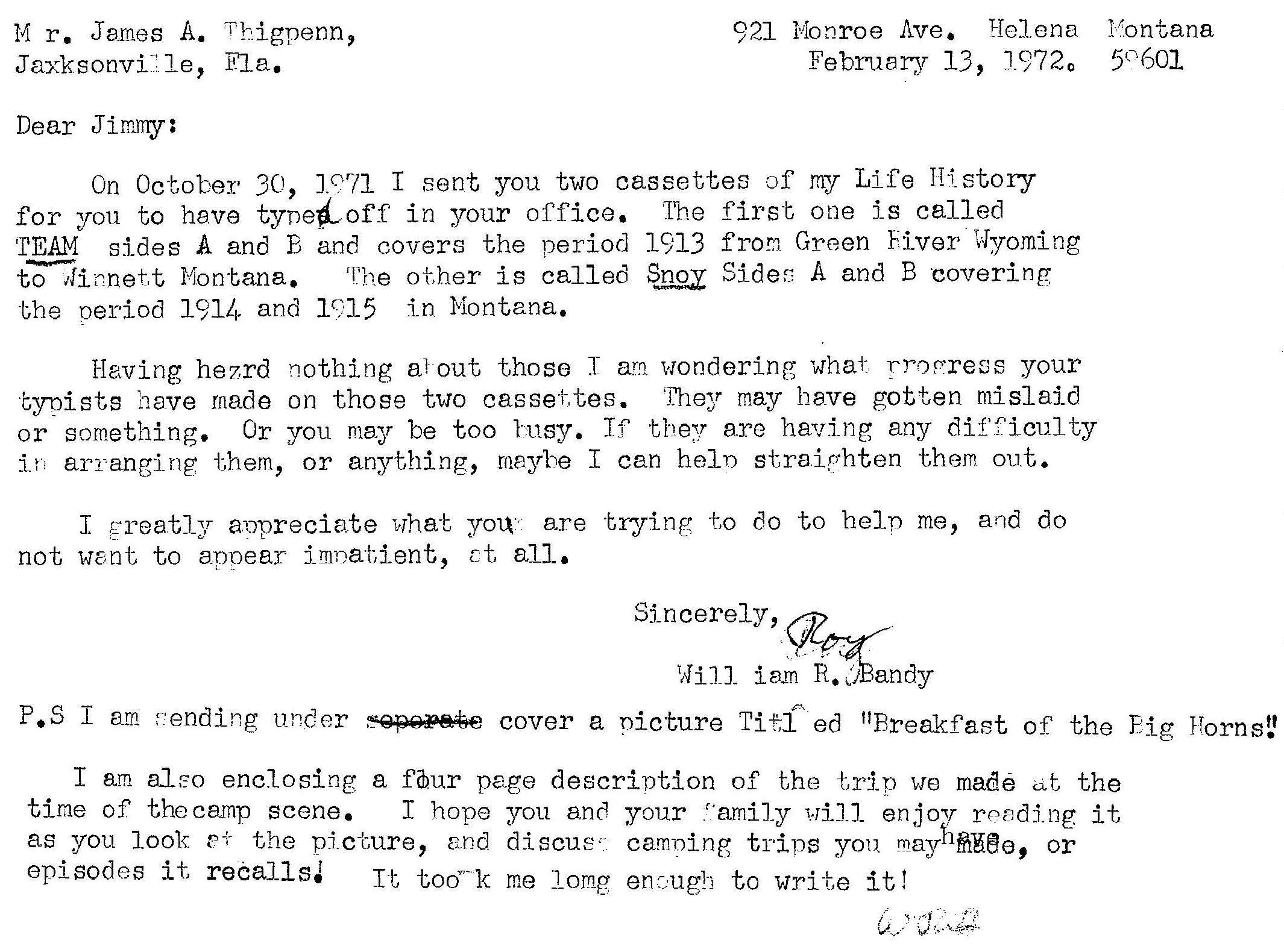
[Correspondence between W.R. Bandy and former FSMS President James Thigpenn III. Bandy was 27 years old at the time of the painting in 1912. He passed away just months after this letter was written, in July of 1972 at age 87.]
March 2023 Page 12

The Florida Surveyor Page 13
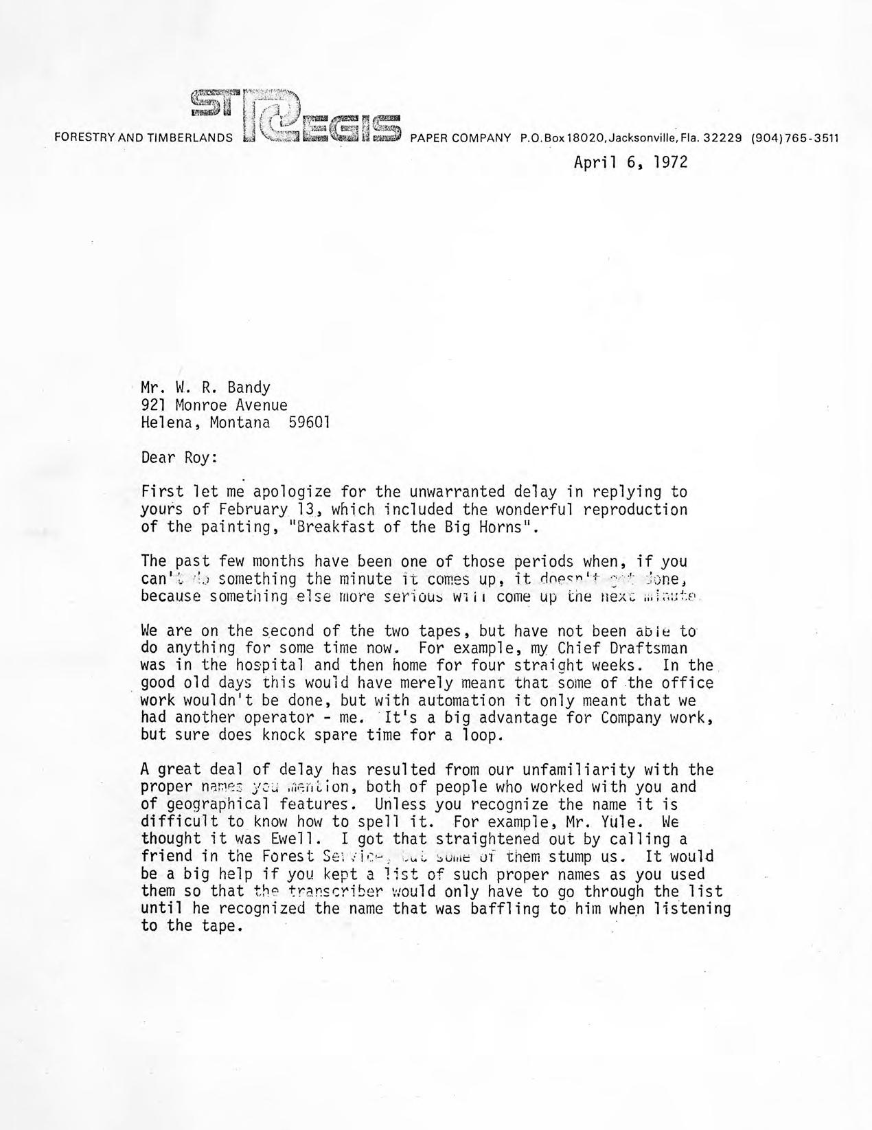
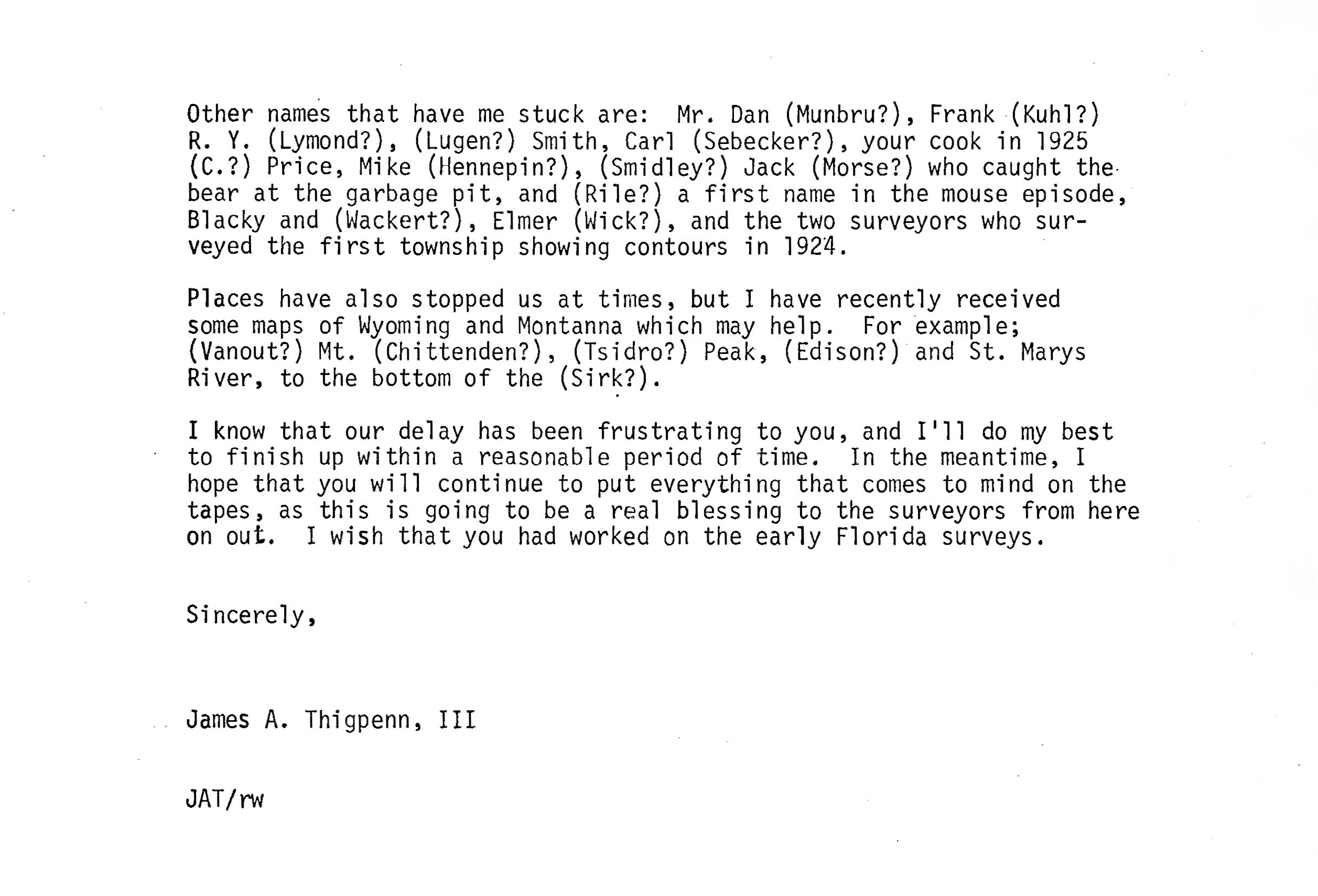
Transcription of handwritten letter of 13 February 197 2 from Roy Bandy to James
Transcribed by Glenn Borkenhagen on 03 November 2018
Dear Jimmy: -
Thigpenn
Helena Feb 13 ‘72
The enclosed picture is a photograph of a 21 x 30” oil painting I have over my fire place. The painting is [from?] an enlarged Kodak picture I made of my survey camp at an over-night stop on the summit of the Big Horn Mts. while enroute from one job to another. It was in August 1912 at an elevation of 9560 feet. Another wagon and the horses to the right are not shown.
My Wife, Inez was cook, we had not been married very long. She is frying ruffed grouse for breakfast. My brother Willis, far left, killed as we traveled along an old trail that is “nobody knows how old”. The old trail probably was originally made by buffalo and indians traveling from summer range to winter feeding grounds in prairie country of eastern Montana. None of us had ever been i n that country before. We were picking our way, following directions given by sheep men. The only wagons to travel it had been sheep men, and they only went as far as the state line. The Crow Indian Reservation lay on the Montana side, so we were on our own in finding a way off the mountains down into the Little Big Horn river valley. It was rough and precipitous. It was nearing sundown as we approached that campsite, and the big snow bank offered the first water we had seen for our over-night camp. A small amount trickled for a ways below the crusted snow.
As soon as the wagons stopped every one began to get supper started, - unload the cook stove, get fire wood, dig food from boxes, peel potatoes, cut ham, wipe dust off the dishes from the cupboard in the back of the wagon. This accounts for the clutter of pots and pans scattered about.
A tent was set up for Inez, others slept out under the star-studded dome.
Soon the smell of frying ham and boiling coffee wafted on the breeze.
The next morning the creek was dry, and ice was on the water pails I had filled the evening before! The horses, turned loose to graze during the night had no water until 2 o’clock in the afternoon.
I was prompted to snap the picture of the early morning as I stood waiti ng for Inez to cook breakfast. I had no thought of preserving a scene of historical value. I wanted only to preserve the beautiful scene.
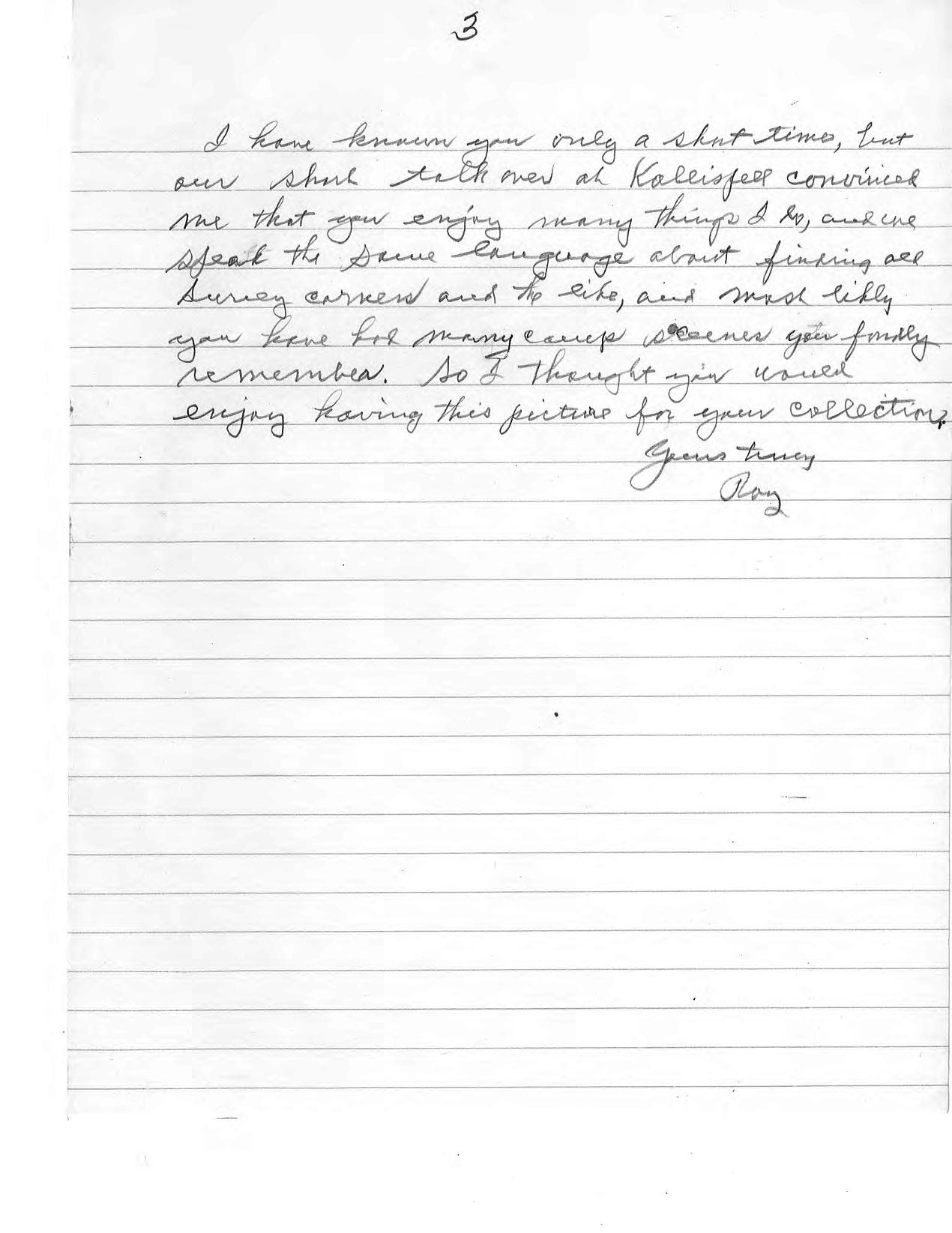
I have known you only a short time, but our short talk over at Kalispell convinced me that you enjoy many things I do, and we speak the same language about finding all Survey corners and the like, and most likely you have had many camp scenes your family remembers. So I thought you would enjoy having this picture for your collection.
Yours truly Roy
March 2023 Page 14
The Florida Surveyor Page 15


• Civil/Site Design • Construction Engineering • Construction Materials Engineering & Testing • Energy • Environmental, Health, and Safety • Geotechnical • MEP • Structural • Survey & Geospatial • Transportation • Urban Planning & Design • Water Resources • Water/Wastewater PARTNERS FOR WHAT’S POSSIBLE www.pennoni.com Join our Survey Team in Florida today!
BREAKFAST ON THE BIG HORNS
By W.R. Bandy
This colorful painting is from an early morning photograph of an over-night camp of my survey party on the summit of the Big Horn Mountains in northern Wyoming. It was breakfast time on that August morning back in 1912. The survey crew was nearing the end of a 200 mile move overland by horse-drawn wagons in order to survey some Homestead lands along the Little Big Horn River. We had camped by this giant bank of last winter's snow because melting snow provided water for our horses and camp. We had found water scarce along the ancient Indian trail we had been following northward along the summit of the Big Horn Range. Most of the springs and water holes in the vicinity of the trail were well down on the slopes, difficult to reach with the heavily loaded wagons. We had traveled late before finding the trickle of water from the snow drift.
We carried with us food supplies, horse feed, tents, dishes, bed-rolls and everything needed for camping out, thus being prepared to live off the country for weeks at a time. It will be remembered that this was long before the day of the plush motels and roadside hamburger stands now available to cross country travelers.
It was the custom then throughout the west for travelers to go prepared to stop wherever night overtook them. Therefore, freighters, surveyors, stockmen and others thought nothing of pitching camp in the edge of town rather than to seek accommodations locally. Usually, of course we were traveling in unsettled country where accommodations were not available. At the time I took this photograph, we were many miles from any settlement, and from any traveled road.
There was no thought at the time that the scene might at some time in the distant future have historical value. However, a close study of the painting does reveal many interesting features peculiar to that time only.
A leisurely contemplation of the artist's work, and by letting one's imagination have full sway, especially if he enjoys the outdoor life, one can read much between the lines. This would be especially true if one knew some of the crew members!
One familiar with outdoor life and similar surroundings may sit and ponder this painting and relive many of the better experiences of his life. Wide is the range his imagination will take him if he gives it free rein! Most of them will have happy
The Florida Surveyor Page 17
endings, for the Good Lord has fixed us so we tend to remember better our more pleasant experiences. One of the greater values of a painting of this kind are the memories it recalls to mind; deeds of yesteryear, possibly tender moments words cannot describe! “Art! Its value lies in what its worth to live with, for that is the true value of Art.”
The decision to take a picture of the camp that morning came to me on the spur of the moment as I awaited the call to breakfast, enjoying the aroma of frying mountain grouse and the coffee pot. The bright sun rising slowly in the east, behind me, cast a warm glow upon the colorful domestic scene ahead, catching a perfect view of my wife, Inez, as she stands rosy cheeked that frosty morning between the stove and the red and green painted wagon. She dominates the scene as the center of attraction, so aptly planned by the skillful artist.
With the stove loaded with frying pans and skillets, she deftly spears a choice piece of tender grouse with that ever busy left hand of hers. So intent is she, my picture taking went unnoticed. It is that unforgettable scene that I wished to record for the admiration of future generations!
I should mention here that I was not really in the picture. The artist painted me in place of the teamster who was standing there expectantly, with plate in hand! My brother, Willis, standing in rear had bagged the tasty grouse with his 22 Special Colts.
About Our Camp
Our little camp stood there, nestled in the shelter of a natural cove. Protected from the north winds by towering Sheep Mountain (not shown). The background of our camp scene is a most unusual one for a wagon camp to have in mid-summer. It was none other than a 50 foot deep bank of crusted snow, the remains of drifts many times that size. After breakfast, the crew could not resist the temptation to have a frolic on the snowdrift on that mid-summer day, and have their pictures made as they clamored over the ice-hard snow. The very existence of this giant snowdrift testifies to the high altitude of the place, which, according to a nearby bench mark established by the U.S. Geological Survey, is 9,546 feet above sea level.
Although we were well above timber line, and it froze ice every night, many alpine flowers and shrubs were struggling to live out their life cycle in spite of the handicaps! As the snow's edge moved slowly upward, gradually uncovering
March 2023 Page 18
FSMS LEGISLATIVE NEWS... AND A REMINDER ABOUT PAC DUES

Greetings FSMS Members!
Following the amazing success of last year’s Legislative efforts, it’s once again time to prepare for the upcoming Florida Legislative Session (March 7 through May 5). Our Committees, Lobbyists and PAC are working hard to ensure strong relationships with our elected leaders.
Simply stated, without the actions, efforts and policies of the Florida Surveying and Mapping Society, our profession would have long ago been de-regulated. That’s a bold statement, but it is a fact, and if you wish to continue as a regulated profession, we must continue to build our membership and re-load our PAC.
Please consider investing in the future of your Profession through a contribution to the FSM PAC. (Link to Contribution Page)
The Officers of the Florida Surveyors and Mappers Political Action Committee (FSMPAC) are Jack Breed (Chair), David Daniel (Treasurer), John Clyatt, and Don Elder.
Your FSMS Legislative Committee: Jack Breed (chair), John Clyatt, Sam Hall, Russell Hyatt, Brian Murphy, Ray Niles, Chad Thurner, Don Elder, Leo Mills, Dodie Keith, Randy Tompkins and Howard Ehmke (ex officio).

the dormant plants, the impatient buttercups, Johnny Jumpups, snowdrops, and clustering rock asters lost no time in adding their “thing” to brighten their part of the world.
Even with an inch or more of snow yet to go, the sun's life giving rays penetrated the icy pane, causing the struggling bulb to push up through the ice, straighten up its head and unfold in all its glory! Some of us stuck flowers in our hatbands. It was proper to pick wild flowers under those circumstances! That was as it should be. How else would the little flower get up in the world? That was their only chance to add their bit! Had it not been for our accidental visit, those beauties might have lived in vain! Probably a long, long wait before other visitors came.
Other Visitors
The existence of half buried teepee rocks nearby bore silent proof of other visits by humans ages ago. Who? When? Let's pretend it was a demure Indian maiden happily picking flowers in the alpine garden above the clouds!
Permanent Residents!
As we romped over the rocky ledges along the ridge top and over the long sliderock slopes, other residents made their presence known. A brown marmot the size of a badger would stand at the door of his rocky home and bark his defiance. Then lope to his neighbor's door, keeping flat on the ground. His short legs, made for digging, seemed to stick out instead of down as he ran. The little four inch long coney sits on his haunches with his ears sticking up, and his mouth full of grass. He's ready to dive in if you make a false move. He's the greatest hay maker! He's forever carrying hay into his den, preparing for a hard winter!
But we must move on! We've got surveying to do at the end of the road! With wagons piled high with tents and beds, we climb on top and yell “Wagons Ho.” Winding along the top of the highest ridge we felt as though we were looking down at the whole world! But Lo! Glancing skyward we saw a black speck a half mile above us. A bald eagle, wings motionless, sailed, apparently without effort. Maintaining silent vigil over his domain below! Not much happens in the eagle's homeland that escapes his notice. If a stranger goes near his nesting place, he is quick to scream a warning. Surprisingly, seeing the big bird sailing so high above us, we never once even imagined that one day we might be performing more improbable feats.
March 2023 Page 20
The old trail we have been following has now lead us to where the mountains break off into a series of spurs and canyons sloping down to the prairie lands on the Crow Indian Reservation in Montana. For a ways we are in a sort of no man's land, near the State Line.
The trail begins to peter out. The sheepmen of Wyoming did not graze their sheep in the Indian Reservation and had no reason for taking wagons beyond this point. Likewise, the Indians had no reason for making a road into Wyoming. Being in a strange land with no wagon tracks to follow, we had to judge for ourselves the best route to take to get off the mountain.
To guide us, we could see in the hazy distance a green streak outlining the position of the cottonwoods and fields along the Big Horn River. Off to the right was a smaller green strip where the Little Horn ran. Our plan was to hit the Little Horn valley a few miles north of the Montana Boundary Line. With those features in mind, we must pick our own way, always mindful of the possibility of coming to a jumping off place where we could not get wagons over.
We had to roughlock the rear wheels on hills too steep to get back up if we got stuck. In such cases, we would have someone reconnoiter ahead before going blindly down! Naturally, though we took many chances depending on our judgment in our haste. I might explain that a “roughlock” is made by wrapping a log-chain around the tire of the rear wheel so it would drag on the ground with the end of the chain fastened to the front bolster. As a last resort, on a real steep place a good sized tree with the branches on was tied to the back of the wagon with some boys riding on the tree. We did that once in Wyoming on Dead Indian Hill.
In closing, I will say that luck was with us on this trip. We arrived safely on a traveled road running up the Little Big Horn; whence all we had to do was drive up south a few miles to our next job.
Our caravan consisted of two wagons, a four-horse team, a two-horse team and a saddle-horse, the crew of five survey-aids, a cook, and a teamster. Some are not shown in the painting.
The Florida Surveyor Page 21

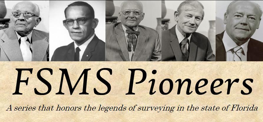
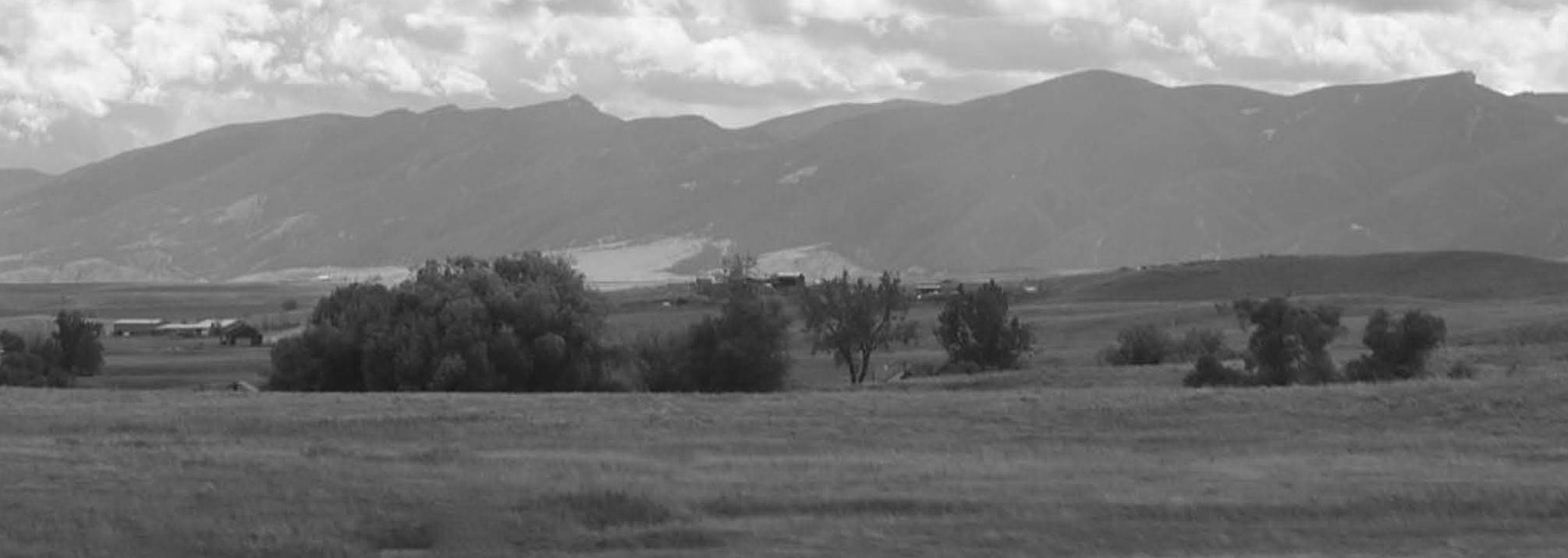
Searching for Roy Bandy’s 1912 Campsite
Glenn Borkenhagen
During August 1912 a General Land Office (GLO) survey party headed by Roy Bandy was traveling across northern Wyoming with two horse-drawn wagons and one saddle horse. The GLO, part of the U.S. Department of the Interior, was the government agency designated by law to survey the public lands and make them available for homesteading, sale, or transfer by other means from federal to private ownership. This crew had just finished work associated with some homestead entry surveys in Wyoming’s Sunlight Basin about 19 miles southeast of Cooke City, Montana and was headed for the area of the Little Bighorn River about 14 miles west of Parkman, Wyoming to complete a township survey begun in 1902 to enable finalization of some homestead claims.
Their route took them along the summit of the Bighorn Mountains within the Bighorn National Forest, and the evening of 12 August the party traveled until dusk before finding and camping beside a snowbank left from the previous winter. As they were traveling high above any flowing streams, the snowbank was a welcome sight that would provide water for the crew and their horses.
The next morning, Roy Bandy captured a Kodak photo of their campsite with the snowbank in the background as his wife Inez, the cook for the party, was preparing breakfast. Almost 60 years later, in 1970, Roy and his daughter Zoe Reith commissioned Irvin “Shorty” Shope, a popular Montana artist, to create an oil painting titled Breakfast on the Big Horns (Figure 1) based on that photo in memory of Inez. Prints of that painting are
The Florida Surveyor Page 23
Figure 1 - Breakfast on the Big Horns, oil painting by Irvin “Shorty” Shope, 1970
regularly offered on scholarship auctions sponsored by the Montana Association of Registered Land Surveyors (MARLS) at their annual conferences, as well as being sold outright by MARLS, and now grace the walls of many offices and homes in the region.
William Roy Bandy (1885-1972) began his land-surveying career in 1905 near Garland, Wyoming while employed by a surveyor performing work for the GLO on a contract basis. In 1906 Bandy was appointed a U.S. Deputy Surveyor, reportedly the youngest person to receive such an appointment. During 1907 through 1910 he worked as a surveyor and engineer on canal and tunnel construction for irrigation projects, both federal and private, in Wyoming and Idaho.
In 1910 the GLO, in accordance with a new law, ended their previous practice of awarding contracts for surveys of public land. Such surveys were thereafter to be done by surveyors directly employed by the GLO. In 1911, newly married and looking for stable employment, Mr. Bandy accepted employment as a U.S. Transitman with the Wyoming office of the GLO with headquarters in Cheyenne. His first assignment included the resurvey of six townships around and to the north of Cody. His wife Inez joined the party as cook. In 1914 he was transferred to the Montana GLO headquartered at Helena where he remained through 1945 except for a few special details.
In 1930 Bandy earned a Bachelor of Law degree from the Blackstone Institute of Law of Chicago, Illinois.
In 1929 and 1930 Congress enacted legislation changing large parts of the north and east boundaries of Yellowstone National Park from the original rectangle defined at the park’s establishment in 1872 by parallels of latitude and meridians of longitude to a shape in part defined by the crests of mountain ranges that divided watersheds. During 1931 through 1933 Bandy and his crews surveyed the rough and remote eastern boundary of the park as well as the revised portions of the park’s northern boundary.
The summer of 1936 found Bandy (then 51 years old) leading survey parties doing township completion surveys in the rugged mountains around Cooke City, Montana and along the eastern side of the Pryor Mountains, an area previously considered to be impossible to survey.
During the mid-1940s the Pick-Sloan Missouri Basin Program, which provided a comprehensive plan for the conservation, control, and use of water resources in the entire Missouri River Basin, began to take shape under direction of the U.S. Bureau of Reclamation, part of the U.S. Department of the Interior. In 1946 the GLO Director placed Bandy in charge of all public land surveys in the ten Missouri River Basin states with the title Cadastral Engineer, a position he held until he retired at the end of 1954. Upon completion of his long career of government service, the Secretary of the Interior granted Mr. Bandy the Department’s highest honor, the Distinguished Service Award.
In his retirement, Bandy wrote several articles that appeared in local newspapers as well as in regional and national magazines. He also served as a consultant on property and boundary issues.
This writer, the successful bidder on a framed print of Breakfast on the Big Horns at a MARLS scholarship auction held sometime in the late 1990s or early 2000s, had for several years considered an attempt to locate Bandy’s 1912 campsite. The writer’s home in Cody, Wyoming is about 65 air miles from the search area.
At a Wyoming Engineering Society convention I mentioned this possible quest to Joel Ebner, who was at the time a cadastral surveyor assigned to the Gillette, Wyoming office of the Bureau of Land Management (BLM –established in 1946 when the GLO was merged with the U.S. Grazing Service). A few weeks later, Mr. Ebner sent an envelope (postmark reads 03 April 2003) containing several items including photocopies of pages from a 1991 BLM publication titled Running Line – Recollections of Surveyors that contain a Bandy account of the party’s journey across the Bighorn Mountains. Also included were documents related to the work they were
March 2023 Page 24
traveling to as well as a photocopy of the title page of Legal Principles of Property Boundary Location on the Ground in the Public Land Survey States (by Ira M. Tillotson, 1973) that features Breakfast on the Big Horns. The page immediately opposite the title page of the Tillotson book includes an explanation of the painting written by Roy Bandy that states the elevation of the campsite as 9,560 feet. The same Bandy writing also appears on the back of my framed print of Breakfast on the Big Horns.
My campaign to locate the campsite remained stuck in “Park” until the summer of 2018. My initial activities included downloading and acquiring from others historic maps of the area, investigating historic travel routes in the area, and trying to locate a print of the photo on which the painting is based.
Bandy’s account in Running Line . . . states they crossed the Bighorn River at Kane, Wyoming where a ferr y was in operation. Until U.S. Highway 14A was relocated to its current alignment in 1983 that route ascended the west side of the Bighorns via the Five Springs Creek drainage to around 8,000 feet elevation before turning south into the Crystal Creek drainage and passing south of Medicine Mountain. I contacted various people with historical knowledge of the region and they agreed that this was likely the route in use during 1912 by persons with teams and wagons en route to the top of the Bighorns. A 1914 Bighorn National Forest map shows this route being used to reach the Porcupine Creek Ranger Station (now known as the Porcupine Ranger Station; that name appears on a 1927 Bighorn National Forest map) from the west. That 1914 map also shows a sawmill along that route close to the western Forest boundary.
Information provided in 2003 by Joel Ebner showed the location of the surveys the Bandy party performed after reaching their destination. Bandy’s account includes the name of the homestead entryman, W.T. Broderick, waiting for their arrival. Searching the online GLO records defined the lands patented to Mr. Broderick.
In 1901 the U.S. Geological Survey (USGS) issued the Bald Mountain 30-minute (1:125,000 scale) quadrangle map (hereinafter referred to as a “quad”). That map was part of a massive campaign to map the newly established Forest Reserves, which became today’s National Forests. The 1901 Bald Mountain quad shows a group of unimproved roads running from area of the Porcupine Creek / Porcupine Ranger Station up over Duncom Mountain, then north and east until entering Montana a few miles west of the Little Bighorn River and the part y’s destination. Those roads still exist today; the ones of primary interest are known by the names Sheep Mountain Road (Forest Service Road 11) and Marble Quarry Road (Forest Service Road 111).
Due to terrain and available roads the Bandy party would have traveled through southern Montana for about seven miles before re-entering Wyoming on the way to their destination. The Wyoming road now designated by Sheridan County as Pass Creek Road also appears on the 1901 Bald Mountain quad.
It remains a mystery how Roy Bandy determined the elevation of the campsite. Did he simply interpolate the elevation from the 100-foot-interval contour lines on a U.S. Geological Survey (USGS) quad? Field notes of the work done at their destination state they did have a clinometer which they used while chaining to determine true horizontal distances. Did they use their transit or clinometer to derive elevation by employing trigonometric leveling to a local bench mark? Or did they just read the elevation on a bench mark they passed (a bench mark very close to Sheep Mountain Road was marked "9566 SHER" and the group would have passed it - the capless pipe was still protruding from the ground on 17 September 2018 but was found broken off flush with ground on 13 August 2020) and call that good?
Drawing from the rather precise elevation mentioned above, I decided to concentrate on sites with elevations between 9,500 and 9,600 feet. I created a KMZ file consisting of contour lines at those elevations and opened it in Google Earth.
The latest Google Earth satellite imagery for the general area was (and still is) dated 25 June 2017. Several areas along the route of interest (generally described as between roughly three to eight miles north of U.S.
The Florida Surveyor Page 25
Highway 14A along the Big Horn-Sheridan County line, which in that area follows the hydrologic divide between the Bighorn River to the west and the Little Bighorn River to the east) showed snow remaining on that date at between 9,500 and 9,600 feet elevation.
I reached Roy's grandson Dirk Reith who is my age, we both graduated high school in 1968. He lives in Hawaii and has a business called Maui Movers. He said that in addition to the original painting that hangs in his living room, he had a box of stuff that Roy left behind to his late mother Zoe Reith (Roy and Inez 's only child who lived to maturity), who in turn left it to him. Dirk said he would go through it and let me know if he found anything that may be of use in my efforts.
During July 2018 I hired an independent researcher based in Helena, Montana to visit the Montana Historical Society (MHS) to see what she could find that could aid my search. The Bandy file at MHS did not have any photos or negatives, but it did include a Bandy manuscript that provided another Breakfast on the Big Horns account, as well as newspaper clippings that included an article Bandy wrote that appeared in the Great Falls Tribune on Sunda y 03 September 1961 that recounted the party’s adventure while crossing the Bighorn River on their return trip to Wyoming’s Bighorn Basin later in 1912. That piece included a cropped photo of the campsite depicted in Breakfast on the Big Horns but was too grainy to be of any use in the immediate project.
My first trip to the area on 03 July 2018 was mainly for orientation and casually looking around on Sheep Mountain Road for someplace obvious.
My second visit on 20 July explored the areas generally southwest of Medicine Mountain with elevations between 9500 and 9600 feet. It quickly became obvious that it would have been impossible to traverse those areas with teams and wagons. That outing did provide plenty of exercise nonetheless.
Before my third outing on 01 August 2018 I used QGIS (an open-source geographic information system [GIS] program) to georeference a road shown on a 1917 Forest Service map onto the 1901 Bald Mountain 15-minute quad, found that they agreed well as to the road location. Loaded that map into my Garmin Montana GPS receiver and headed for the Bighorns. While driving to the search area that morning on Sheep Mountain Road it was noticed that as I got close to Duncom Mountain (which for the purposes of this article I consider to be the summit where U.S. Coast & Geodetic Survey [C&GS] triangulation station DUNCOM [PID PW0564] is located, not the location shown by Google Earth as Duncum Mountain) I was a few hundred feet west of the 1917 road. The current road is on a significant side hill and crosses several gullies, which would have been an unlikely (more like impossible) road alignment before the advent of motorized earthmoving equipment. The 1901/1917 road went across the top of the mountain crossing contour lines at right angles. To the best of this writer’s knowledge, all renditions of the 1901 Bald Mountain USGS quad show this alignment. The C&GS recovery notes for point DUNCOM indicate Sheep Mountain Road was in its current alignment in 1957. The 1960 Bald Mountain 7.5-minute (1:24,000 scale) USGS quad shows the road at its current farther west alignment.
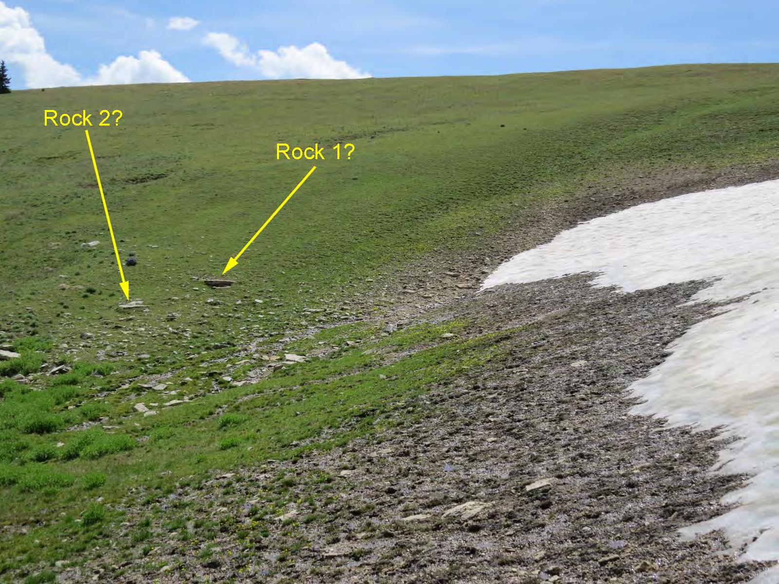
During the morning I walked over the summit of Duncom Mountain looking for possible campsites to the south and east and did not see anything. After lunch I investigated an area spotted earlier from the summit, generally north-northwest of said summit. I believed that to be the most likely campsite. It had a significant amount of snow remaining on 01 August, it being the only wagon-accessible snow I found that day, there was a small stream in a defined channel flowing from the snowbank from which it would have been easy to fill buckets (as mentioned by Bandy in his accounts), the elevation matched the reports, it would have been fairly accessible with teams and wagons with minimal side hill. (This site also had snow remaining on 14 August 2019 and 13 August 2020.)
Around the same time I was discussing this little mission with some Wyoming and Montana surveyors, including Stanton “Stan” Abell (Wyoming and Montana professional engineer and land surveyor) of Worland,
March 2023 Page 26

Wyoming and Kurt Luebke (professional land surveyor in Wyoming, Montana, and eleven additional states) of Missoula, Montana.
During August 2018 Linda Abell (wife of Stan Abell) came across the Bandy Breakfast on the Big Horns account that appeared in the March 2018 issue of The Florida Surveyor. That retelling mentions Sheep Mountain to the north (which is not exactly "towering" as Bandy described it), states the snowbank was 50 feet deep, and indicates the “altitude” as 9546 feet. Here Bandy also describes how they went northeasterly into Montana a few miles to intersect a road that led southeasterly back into Wyoming and the lands to be surveyed, which confirmed the route assumed earlier.
Stan and Linda Abell visited the area during Labor Day weekend of 2018 and Stan offered his own thesis as to the campsite location. Kurt Luebke submitted his idea as well, based only on his examination of the maps and other materials available at the time.
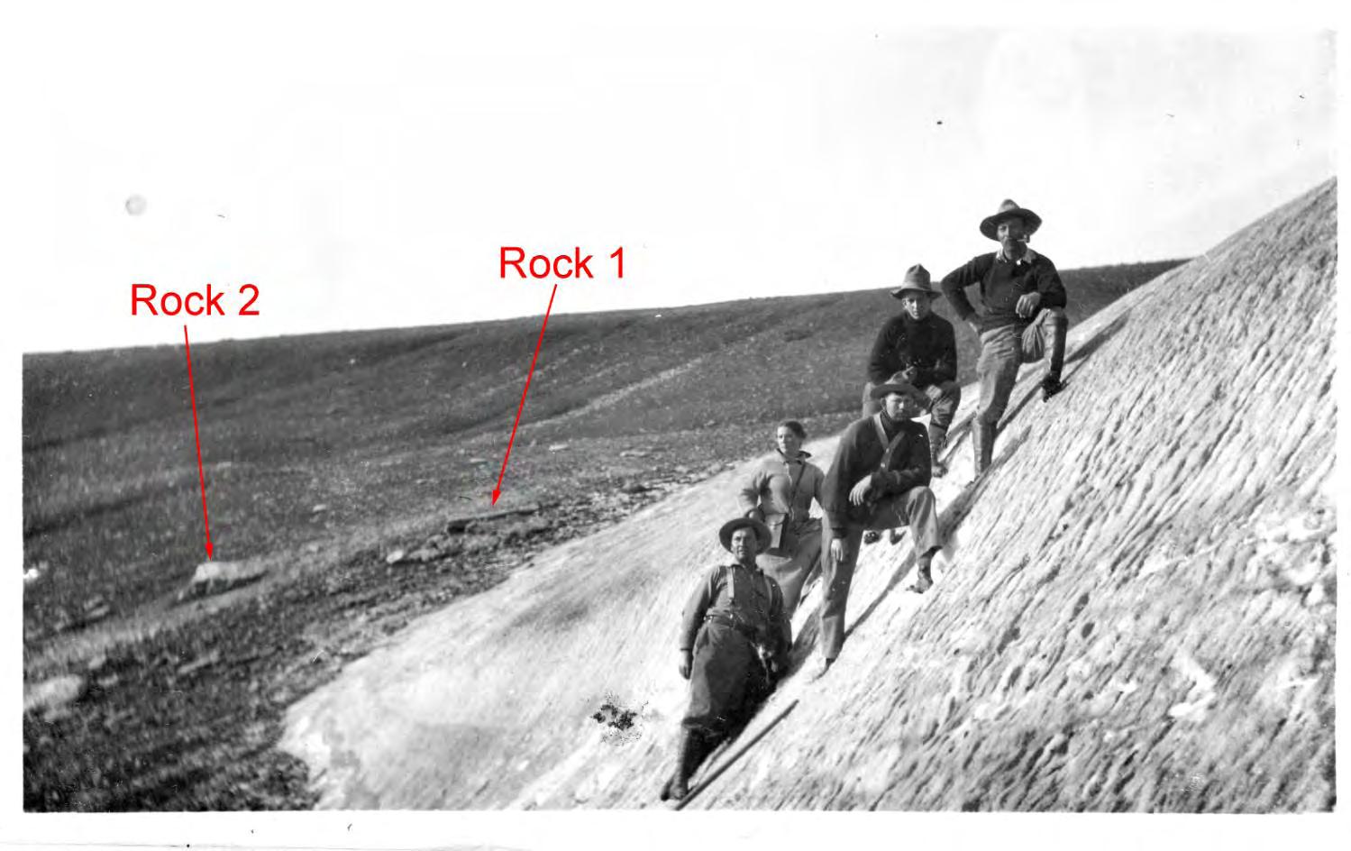
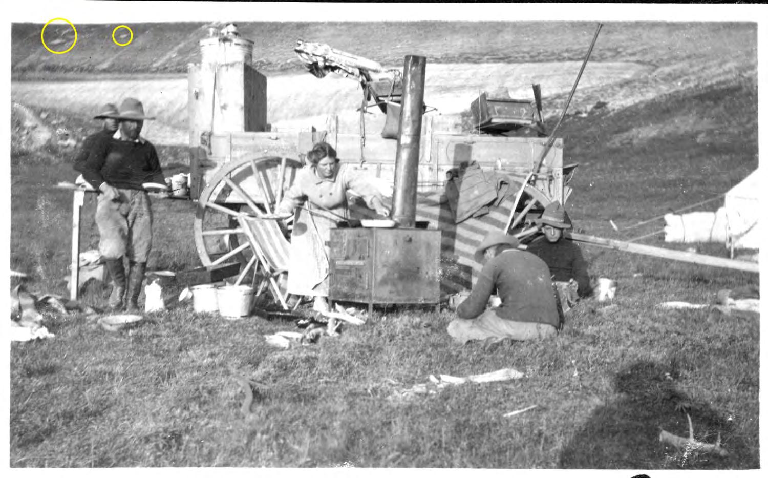
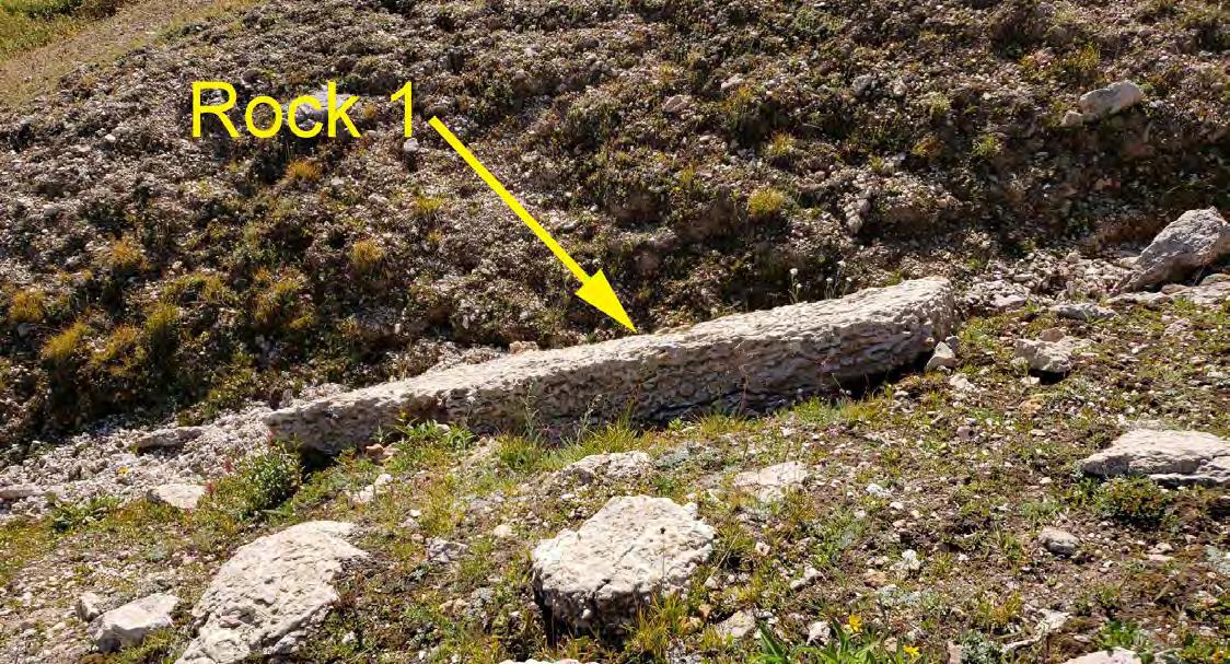
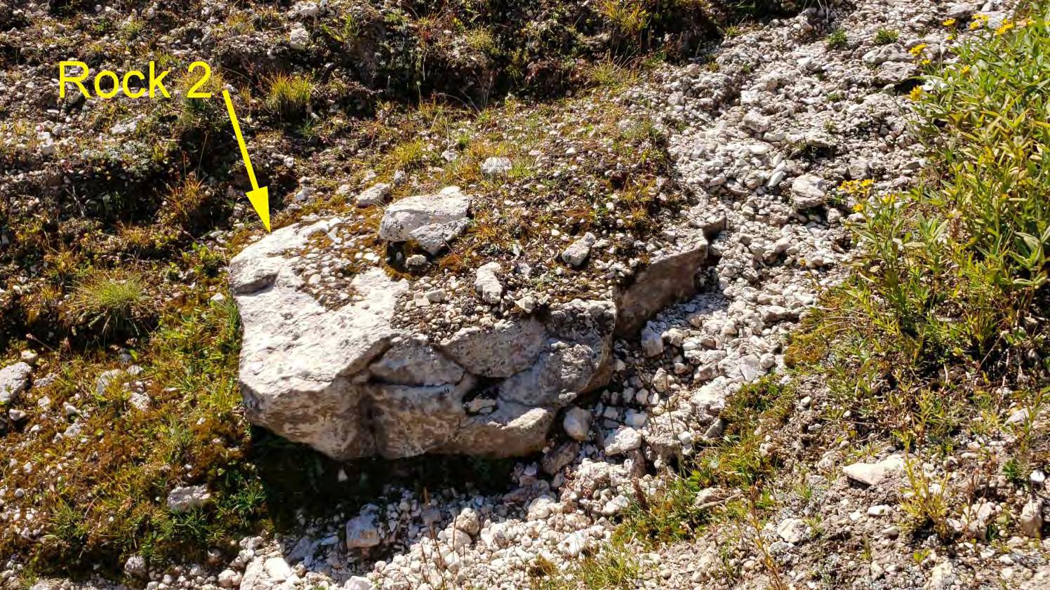
As the anniversary date of the event neared in 2019, I planned a trip to the Bighorns for 14 August. On 13 August I went to the post office and found waiting two boxes from Roy's grandson Dirk. He had sent me everything from some of Roy's grammar-school report cards and letters of reference he brought with him to Wyoming in 1905 to his late-in-life writings. Included were three more accounts of the Breakfast on the Big Horns campsite. I soon found a print of the photo that was the basis for the painting (Figure 7), obviously Roy was not in the photo because he was behind the camera - teamster Karl Suhr is where Roy appears in the painting. There were also two other prints (on postcards) of the group standing on the snowbank, one taken from the north and one from the east. I was off to the races, or so I thought.
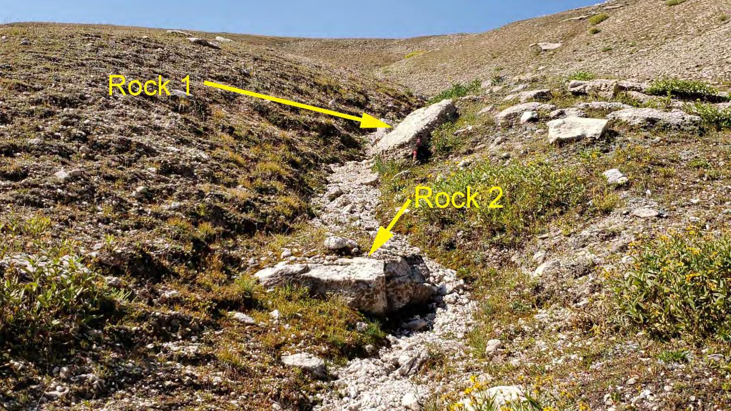
I scanned the photo prints and printed my working copies, then headed up the mountain the next morning. The photo of the group taken from the north showed two good-sized rocks in the background. Those rocks are denoted as Rock 1 and Rock 2 on Figure 2. That photo was taken by Roy’s younger brother Willis Bandy (who appears at the far left in the painting and in Figure 7) and includes Roy at the lower left. Rock 1 and Rock 2 sort-of matched what is now at the site I found the previous summer and that are shown in Figure 3. I walked the areas chosen by Stan and Kurt, and honestly did not see anything matching the background of the from-thenorth image.
March 2023 Page 28
It was believed that Rock 1 and Rock 2 would be the key to identifying the actual campsite. As of that time, the rocks shown on Figure 3 (at the site of my 2018 thesis) appeared to be the closest match to those in the historic image, at least among those seen by this writer. Things can and do change over 110 years, with frost heave, soil accumulation, erosion, etc.
The Florida Surveyor Page 29
Figure 2 – 1912 photo of group on snowbank, taken from the north, with prominent rocks marked
Bandy’s account in The Florida Surveyor described the campsite as being “nestled in the shelter of a natural cove.” My bowl-shaped site seemed to match that characteristic well.
During the 14 August 2019 visit I also located USGS BM 9810 SHER, which supported my original thesis because in USGS Bulletin 558 Results of Spirit Leveling in Wyoming 1896 to 1912 Inclusive (published in 1914) bench mark 9810 SHER is described as being “150 feet east of road”. That information confirms the original location of the road and the path taken by the Bandy party near the Duncom Mountain summit. If one zooms in on the Google Earth imagery dated 25 June 2017 the tracks of this original route are visible 160 feet west of USGS BM 9810 SHER. It is believed they could have seen a snowbank at the site of my 2018 thesis from a wagon seat.
Then on 16 August 2019 I dug further into the materials received from Dirk earlier that week and found a folded copy of the 1960 Boyd Ridge 7.5-minute (1:24,000 scale) USGS quad, which was apparently marked up by Roy himself! In addition to indicating the location of the campsite and the route traveled, Roy also marked the map with the land’s section, township, and range in the Public Land Survey System (PLSS).
March 2023 Page 30
Figure 3 – Prominent rocks seen at site of author’s location thesis of 2018-08-01, as seen on 14 August 2019
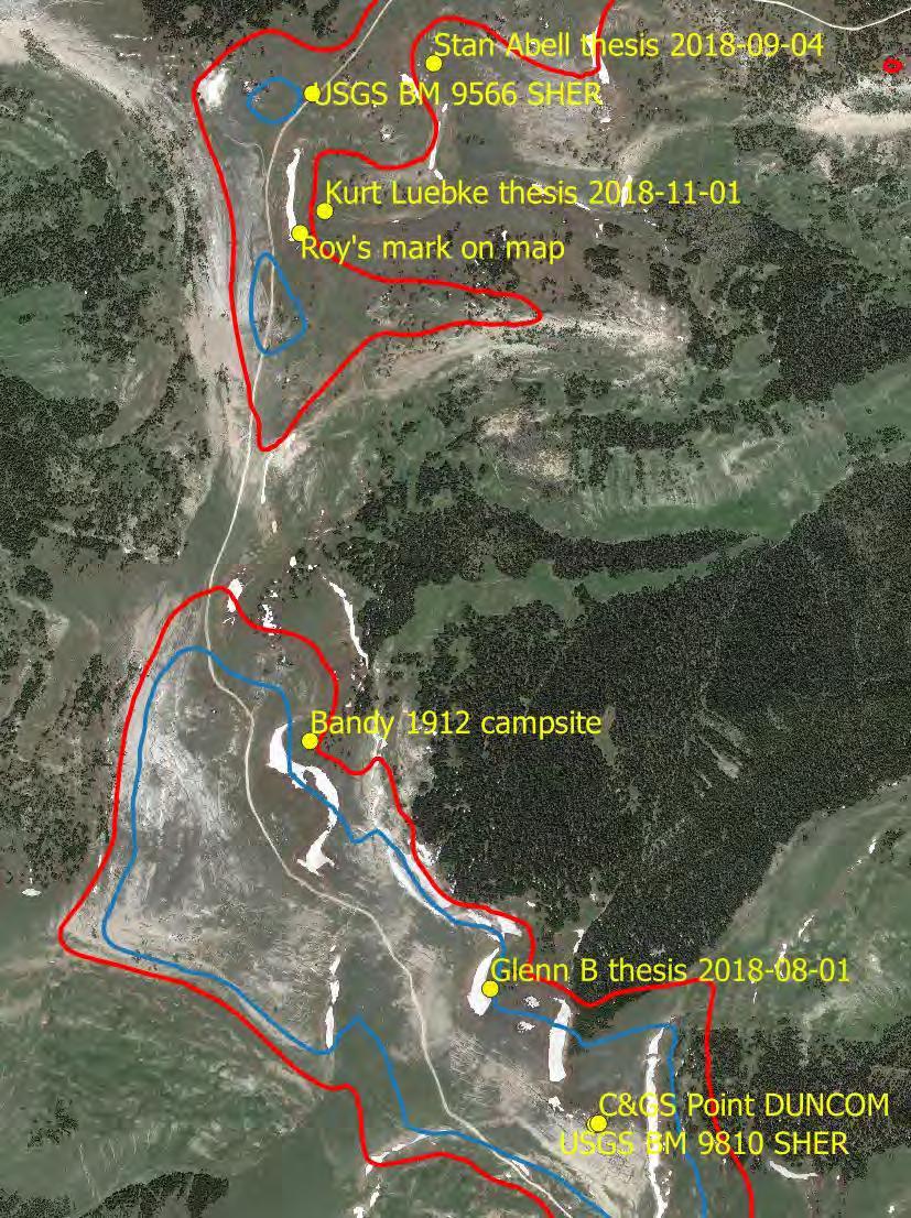
Figure 4 is a satellite image showing where Roy marked the USGS quad of the previous paragraph. It also shows the three location theses presented during 2018, the C&GS triangulation station DUNCOM, and the USGS bench marks 9566 SHER and 9810 SHER. The 9500-foot contour line appears in red and the 9600-foot contour line appears in blue. The white line running south to north is Sheep Mountain Road. Finally, to avoid including another image in this writeup, the actual campsite location is also shown there.
To provide a sense of scale for Figure 4, the distance between USGS BM 9810 SHER on the south end and the Stan Abell thesis 2018-09-04 on the north end is 2.45 miles.
Based on Roy’s mark, Kurt Luebke’s thesis is the winner!
Roy's PLSS statement of Section 5 in Township 55 North Range 91 West Sixth Principal Meridian (S5 T55N R91W) is quite a ways offthat land remains unsurveyed but by protraction shown on the 1993 Boyd Ridge USGS quad it would be Section 28 of Township 57 North Range 91 West. That is roughly 8 miles farther north than Roy's section.
Figure 4 – Annotated satellite image
Nothing found to date indicates Roy ever revisited the site but he and Inez lived in Billings, Montana (about 70 air miles to the north-northwest) for several years in the late-1940s-to-mid 1950s era and he wrote about visiting the Cody-Powell area at least once.
During 2020 I found another version of the Breakfast on the Big Horns story, this one appeared in the Congressional Record – Senate dated 08 September 1972. Roy Bandy passed away on 23 July 1972.
So things were uncertain for a few years. My site from 2018 matched Bandy’s description in several ways, but it was a stretch to believe the rocks in Figure 3 were actually the ones shown in Figure 2. There is nothing in the area selected by Stan and Kurt (as well as where Roy marked the USGS quad) that looks like the background in Figure 2 and that area does not have much of anything for late-season snow (climate change??). Also, there are no visible channels of runoff water in that area.
Cody Schatz (Wyoming professional engineer and land surveyor) of Cody, Wyoming and I went to the area on Sunday 28 June 2020. We walked about two miles that morning, but unfortunately the rain forecast for mid-day arrived right on schedule. A section of the south end of Sheep Mountain Road is steep with some deep ruts so we quickly left the area to avoid getting stuck or worse. We did not have time to check out the site of my 2018 thesis.
The Florida Surveyor Page 31
On Saturday 20 August 2022, 110 years and one week after the photo was taken, three of us (hiking buddies Kathy Morgan and Doneen Fitzsimmons, both of Cody, Wyoming, and myself) ventured back to the area. Our first stop was my favored site from 2018, where I failed to convince my fellow searchers that that was the site pictured in the 1912 photos. They noted that the small drainage features descending right-to-left in the 1912 photo of the group on snowbank viewed from north (Figure 2) were missing (as Kurt Luebke pointed out in an email message in August 2019) and the terrain generally did not match that shown in the photo.
Then we went to the next wagon-accessible site to the north with a historic late-season snowbank, an area I had walked three times previously, including with Cody Schatz on our rain-shortened 2020 search. Cody mentioned that based on his decades-long experience in the area this site is where he had observed the most persistent snowbank. This site does have runoff channels that would have made filling buckets easy. Again nothing matching Rock 1 and Rock 2 was immediately seen, but that did not stop my sharp-eyed teammates from looking for and finding similarities.
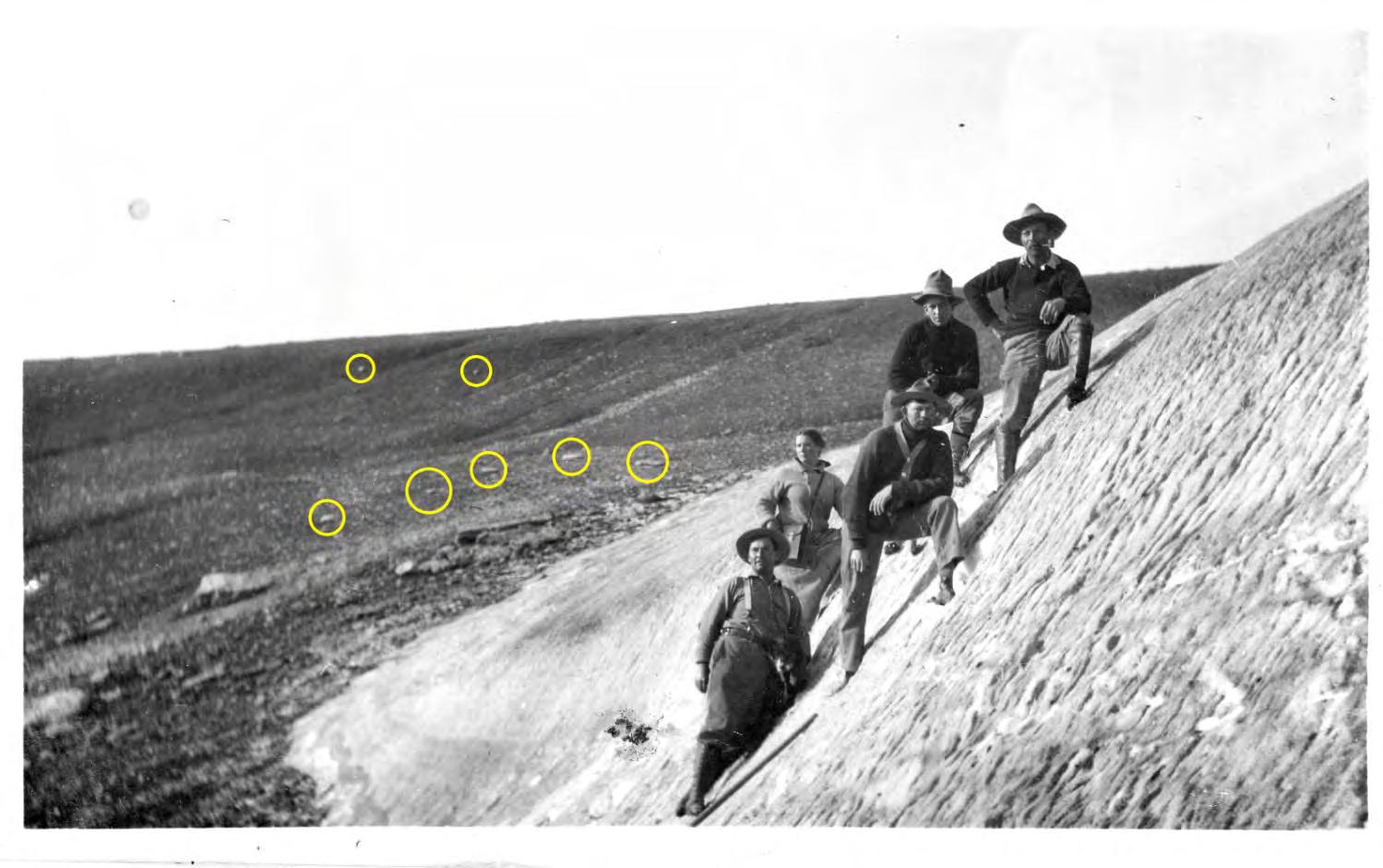
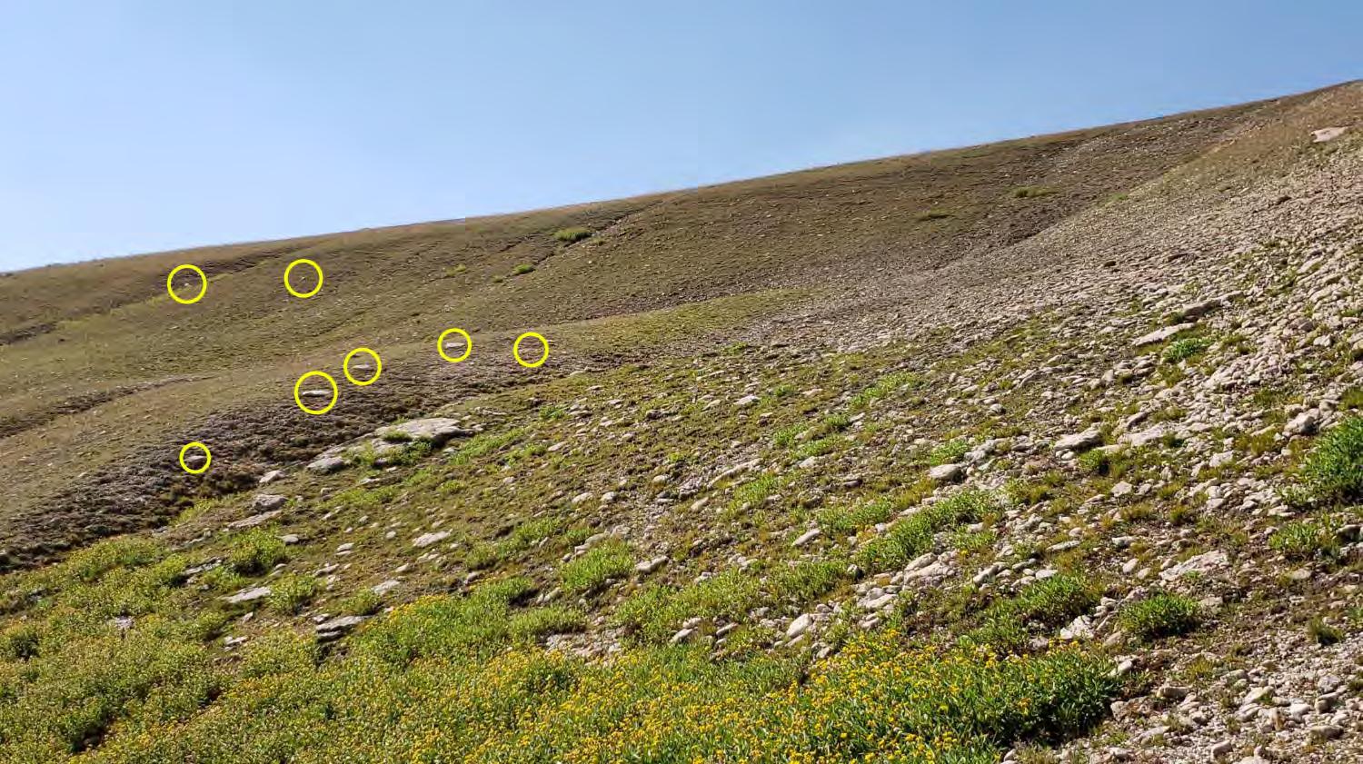
No snow was present this day but Kathy and Doneen soon noted that the terrain features matched those shown in the from-the-north photo of the group on the snowbank. They also observed five or more smaller nearby rocks that matched up nearly perfectly with those appearing in the image of the group on snowbank viewed from north, as well as some farther-away rocks, as shown in Figures 5 and 6. Finally, we noted that the rocks near the horizon in the background of the photo featuring Inez Bandy cooking breakfast agreed with those seen presently. Those are shown in Figures 7 and 8. This site also agreed with Bandy’s account in The Florida Surveyor describing the campsite as being “nestled in the shelter of a natural cove.” On our walk back up to Sheep Mountain Road we noted a long-abandoned two-track path about 140 feet east of the current road that is presumabl y the route used in 1912, which means the snowbank would have been obvious from a wagon. We suspect that they spotted the snowbank as they passed by, then circled around to their right and down to the campsite.
March 2023 Page 32
–
Figure 5
1912
from-the-north image with comparison rocks circled
The Florida Surveyor Page 33
Figure 6 – 2022 from-the-north image with comparison rocks circled
Figure 7 – 1912 from-the-east image of campsite with comparison rocks circled
8 – 2022 from-the-east image with comparison rocks circled
So we determined that the Bandy party’s August 1912 campsite “on the Big Horns” was very close to the site from which the image in Figure 8 was taken, which is 44.87355 degrees north latitude and 107.85802 degrees west longitude. That position is near the northwest corner of the Bald Mountain 7.5-minute (1:24,000 scale) USGS quad.
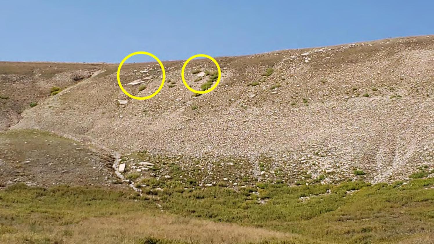
The astute reader will now be asking “What about Rock 1 and Rock 2? They do not appear in Figure 6 (the 2022 comparison image). Where are they?” Well, both of those rocks fell victim to erosion over the past 110 years and are now on the side and bottom of a gully respectively, as shown in Figures 9 through 11. Those rocks also appear from a distance in Figure 8. That is why they went unobserved in my three previous visits to the site.
I learned a valuable lesson that day and gladly give Kathy and Doneen full credit for finding the site. Without them I would still be wandering around looking for Rock 1 and Rock 2, expecting to find them as they appeared in 1912!
March 2023 Page 34
Figure
The Florida Surveyor Page 35
Figure 9 – Rock 1 viewed from the north
Figure 10 – Rock 2 viewed from the northeast
Comments
The day after we located Bandy’s 1912 campsite the temperature was forecast to reach over 90 degrees in Cody. Early on 21 August a group of us headed for Yellowstone National Park (YNP). There we hiked up Avalanche Peak, which is on the eastern border of YNP. My companions humored me on the way down and we took a 0.31-mile side trip to YNP Mile Corner 32½ which was set by Roy Bandy in 1932, 20 years after he took the snapshot memorialized in Breakfast on the Big Horns.
Now my next task is to get all the materials entrusted to me by Roy’s grandson Dirk to someplace where they will be preserved and accessible to future users. Since Roy spent the majority of his life and career in Montana, the Montana Historical Society (MHS) is the logical choice. The MHS facility in Helena is now in the construction phase of being expanded to almost double its current size, and as mentioned above, they already have a William Roy Bandy file. The other leading contender is the American Heritage Center at the University of Wyoming in Laramie.
I have posted an “online” version of this article to one of my download websites. That version includes a number of endnotes and hyperlinks to related information. You can view that version as a PDF at <https://inlandwyo.com/pub/Breakfast on the Big Horns/> in the folder labeled “00 Searching for Roy Bandy’s 1912 Campsite.” Also posted to that site are several of Bandy’s recountings of the Breakfast on the Big Horns story, unmarked scans of the 1912 images, full-size copies of the other figures presented above, a Bandy manuscript, newspaper and magazine articles by Bandy, a scan of the 1960 Boyd Ridge quad with Roy’s markings, old maps, KMZs of points mentioned, tracks of walked routes, and miscellaneous items I came across or generated while researching this little bit of history.
If you find any errors in this presentation or have any questions, suggestions, or criticisms, please contact the writer by email addressed to glenn@inlandgps.com. Make sure to include “Breakfast on the Big Horns” in the subject line.
March 2023 Page 36
Figure 11 – Rock 1 and Rock 2 viewed from the east
Surveyors in Government

March 2023
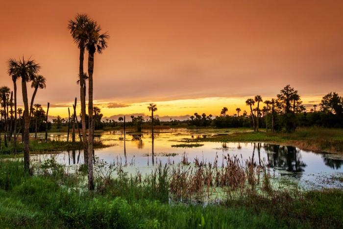
Greetings fellow surveyors in government and those who read the article. Time is rapidly escaping us and before we know it, we will be attending the FIG Working Week and the FSMS Conference, if you are as fortunate as I am. For the City, we are fortunate that they are supportive in the role we have on the state and local level and our participation in professional associations and with specialty groups that deal with an aspect that our departments interact with on a regular basis. That support also allows for participation in work related tasks that may not be surveying scope related. One such item is how I am participating in our Wetland Study. It is map related but they are solely focused on GIS and I am making them aware of related items and the impact as it relates to surveying and Public Works, the department upon which I am organized under.
The participation, although only one meeting, has been great. One pet peeve of mine is how wetlands are the one thing that never seems to be reclaimed or recycled to their once pristine condition, or at least it has not been here. I have been stressing to staffers and engineers that we need to hold our feet to repair the impaired wetlands and not allow them to be plowed under because the Water Management Districts allow them to be destroyed as long as they are a part of a mitigation process. I do not see the benefit to that in every situation, as I see the possibility to save the existing habitat and work with the natural infrastructure and needed benefit the project is trying to ascertain. I have been speaking with the project manager, who actually was our former Public Works Director, on incorporating this into an upcoming project. Me a surveyor asking for this is not always received well, as some may see this as stepping on the toes of our stormwater engineers. I am fortunate that they do not see it that way and are making considerations to incorporate the existing wetlands if it is feasible.
I am happy with the consideration. I am seeing the need for retention of existing environmental infrastructure from my participation in the Florida Floodplain Managers Association and from my interaction with FEMA. There is more weight being put on beneficial function to deal with flooding and a big part of that is the natural wetlands and greenspace buffers that are more desirable than just a retention pond. As surveyors, we are fortunate to interact with wetlands and the surrounding habitat. I know we can get tired of being wet, dealing with snakes and alligators, but I always loved being in a wetland and transition from lowland to upland. I have seen so many different animals and plants and had such an appreciation for the environment. I always state that I am a tree-hugging conservative. How can you not love nature as a surveyor!
I do understand how early surveyors seen this land as wasteland as it would affect the ability to grow crops if they did not drain the lands so it would not flood their crops. As we can all see from the GLO plats and the early sales maps, it was all about farming because they needed the land to provide. They just did not understand the impact that was made in altering the floodplain and today we are working to
The Florida Surveyor Page 37
Surveyors in Government
establish or re-establish drainage conveyance to deal with flooding and water quality standards. That work has been continually working its way back to natural solutions where the manmade solutions have not delivered to the capacity of what natural functions, when properly operating, can provide.
In this all that I am saying is we as professionals have an opportunity to provide feedback on areas that we may not be experts, but have experience in observing and interacting with on a routine basis. Thank you for taking the time to read this article!
Source: Orlando Wetlands Park, atrishoutofwater.com/2017/12/30/Orlando-wetlands/
Sincerely,
Richard Allen, City Surveyor for the City of Orlando
FSMS Surveyors in Government Liaison
407.246.2788 (O)
Richard.Allen@orlando.gov
March 2023 Page 38
202 3 S u S taining
Ardurra, Inc. 239-292-7773
Associated Land Surveying & Mapping, Inc. 407-869-5002 Atwell, LLC 866-850-4200

Avirom & Associates, Inc. 561-392-2594 Axis Geospatial, LLC 410-822-1441
Bello & Bello Land Surveying Corporation 305-251-9606
Benchmark Surveying & Land Planning, Inc. 850-994-4882
Bennett-Panfil, Inc. 941-497-1290
Berntsen International 608-443-2772
Betsy Lindsay, Inc. 772-286-5753
Biscayne Engineering Company, Inc. 305-324-7671
Banks Engineering 239-939-5490
Barnes, Ferland and Associates, Inc. 407-896-8608
Barraco & Associates, Inc. 239-461-3170
Bartram Trail Surveying, Inc. 904-284-2224
Boatwright Land Surveyors, Inc. 904-241-8550
Bock & Clark Corporation(NV5) 330-665-4821
Bowman Consulting Group 703-454-1000
Bradshaw-Niles & Associates, Inc. 904-829-2591
Brown & Phillips, Inc. 561-615-3988
BSE Consultants, Inc. 321-725-3674
& Harper, Inc. 850-763-7427
Associates, Inc. 772-562-4191 Caulfield & Wheeler 561-392-1991 Chastain-Skillman, Inc. 863-646-1402 CHW Professional Consultants (Causseaux, Hewett & Walpole, Inc.) 352-331-1976
A
American
3002 Surveying 352-538-1320
A. D. Platt & Associates, Inc. 850-329-5551 Agnoli, Barber & Brundage, Inc. 239-597-3111 AIM Engineering & Surveying 239-332-4569 Allen & Company, Inc. 407-654-5355 Allen Engineering 321-783-7443
Surveying, Inc. 813-234-0103 Amerritt, Inc. 813-221-5200 Arc Surveying & Mapping, Inc. 904-384-8377
B
C
Buchanan
Carter
F irm S Directory
CivilSurv Design Group, Inc.
863-646-4771 Clements Surveying, Inc.
941-729-6690
Clymer Farner Barley Surveying, Inc.
352-748-3126
Coastal Engineering Associates, Inc.
352-796-9423
Colliers Engineering & Design
732-383-1950
Collins Survey Consulting, LLC.
863-606-2155
Cousins Surveyors & Associates, Inc.
954-689-7766
CPH Consulting, LLC
407-322-6841
Craven-Thompson & Associates, Inc.
954-739-6400
Culpepper & Terpening, Inc. 772-464-3537
Cumbey & Fair, Inc. 727-797-8982
DroneView Technologies
248-321-9417
DSW Surveying & Mapping, PLC. 352-735-3796
DDuncan-Parnell, Inc.
800-849-7708
DeGrove Surveyors, Inc. 904-722-0400
Dennis J. Leavy & Associates
561-753-0650
Donald W. McIntosh Associates, Inc. 407-644-4068
Donoghue Construction Layout, LLC. 321-248-7979
Douglass, Leavy & Associates, Inc. 954-344-7994
DRMP, Inc. 833-811-3767
Durden Surveying and Mapping, Inc. 904-853-6822
Engineering Design & Construction, Inc. 772-462-2455
ER Brownell & Associates, Inc. 305-860-3866
ETM Suryeying & Mapping 904-642-8550
Exacta Land Surveyors, Inc. 866-735-1916
EEXP Energy Services Inc. 305-213-9969
ECHO UES, Inc.
888-778-3246
Eda Consultants, Inc.
352-373-3541
Eiland & Associates, Inc. 904-272-1000
Element Engineering Group, LLC.

813-386-2101
Engenuity Group, Inc.
561-655-1151
F Ferguson Land Surveyors 727-230-9606
First Choice Surveying, Inc. 407-951-3425
Florida Design Consultants, Inc. 727-849-7588
202 3 S u S taining
Florida Engineering & Surveying, LLC. 941-485-3100
FLT Geosystems 954-763-5300
Ford, Armenteros & Fernandez, Inc. 305-477-6472
Fortin, Leavey, Skiles, Inc. 305-653-4493
Frontier Precision Unmanned 701-222-2030
F.R.S. & Associates, Inc. 561-478-7178
Geomatics Corporation 904-824-3086 Geo Networking, Inc. 407-549-5075
GeoPoint Surveying, Inc. 813-248-8888
George F. Young 727-822-4317
Geosurv, LLC 877-407-3734
Germaine Surveying, Inc. 863-385-6856
GPI Geospatial, Inc. 407-851-7880
Haley Ward, Inc. 207-989-4824
Hanson Professional Services, Inc. 217-788-2450
Hanson, Walter & Associates, Inc. 407-847-9433
H.L. Bennett & Associates, Inc. 863-675-8882
Hole Montes, Inc. 239-254-2000
HUB International 850-386-1111
John Ibarra & Associates, Inc. 305-262-0400
John Mella & Associates, Inc. 813-232-9441
Johnston’s Surveying, Inc. 407-847-2179
GCY, Inc. 772-286-8083
GeoData Consultants, Inc 407-732-6965
Geoline Surveying 386-418-0500
Gustin, Cothern & Tucker, Inc. 850-678-5141
Hyatt Survey Services 941-748-4693
KCI Technologies 954-776-1616
Keith and Associates, Inc. 954-788-3400 Kendrick Land Surveying, LLC 863-533-4874
II.F. Rooks & Associates, LLC. 813-752-2113
G
H
J
K
F irm S Directory
L L&S Diversified, LLC. 407-681-3836 Land Precision Corporation 727-796-2737 Landmark Engineering & Surveying Corporation 813-621-7841 Langan Engineering and Environmental Services, Inc. 973-560-4900 Leading Edge Land Services, Inc. 407-351-6730 Leiter Perez & Associates, Inc. 305-652-5133 Lengemann Corp. 800-342-9238 Leo Mills & Associates 941-722-2460 Long Surveying, Inc. 407-330-9717 M Manuel G. Vera & Associates, Inc. 305-221-6210 Massey-Richards Surveying & Mapping, LLC. 305-853-0066 Masteller, Moler & Taylor, Inc. 772-564-8050 McKim & Creed, Inc. 919-233-8091 McLaughlin Engineering, Co. 954-763-7611 Metron Surveying and Mapping, LLC. 239-275-8575 Mock Roos & Associates, Inc. 561-683-3113 Moore Bass Consulting, Inc. 850-222-5678 Morris-Depew Associates, Inc. 239-337-3993 Murphy’s Land Surveying 727-347-8740 N Navigation Electronics, Inc. 337-237-1413 Northwest Surveying, Inc. 813-889-9236 NV5 - Technical Engineering & Consulting Solutions 954-495-2112 O On The Mark Surveying, LLC. 321-626-6376 P PEC Surveying & Mapping 407-542-4967 Pennoni Associates, Inc. 863-594-2007 Perret and Associates, Inc 904-805-0030 Pickett & Associates, Inc. 863-533-9095 Platinum Surveying & Mapping, LLC. 863-904-4699 Point Break Surveying 941-378-4797 Polaris Associates, Inc. 727-461-6113 Porter Geographical Positioning & Surveying, Inc. 863-853-1496
Pulice Land Surveyors, Inc. 954-572-1777 Q Q Grady Minor & Associates, PA 239-947-1144 R Reece & White Land Surveying, Inc. 305-872-1348 Rhodes & Rhodes Land Surveying, Inc. 239-405-8166 Richard P. Clarson & Associates, Inc. 904-396-2623 R.J. Rhodes Engineering, Inc. 941-924-1600 R.M. Barrineau & Associates, Inc. 352-622-3133 Robayna and Associates, Inc. 305-823-9316 S SAM Surveying & Mapping, LLC. 850-385-1179 SCR & Associates NWFL Inc. 850-527-1910 Sergio Redondo & Associates, Inc. 305-378-4443 Settimio Consulting Services, Inc. 850-341-0507 SGC Engineering, LLC. 407-637-2588 Shah Drotos & Associates, PA 954-943-9433 Sherco, Inc. 863-453-4113 Sliger & Associates, Inc. 386-761-5385 Southeastern Surveying & Mapping Corp. 407-292-8580 Stephen H. Gibbs Land Surveyors, Inc. 954-923-7666 Stoner Inc. 954-585-0997 Surveying & Mapping Inc. 239-340-2409 SurvTech Solutions, Inc. 813-621-4929 T T2 UES Inc. 407-587-0603 Tectonic Engineering and Surveying Consultants 845-534-5959 Thurman Roddenberry & Associates 850-962-2538 TranSystems Corporation Consultants 727-822-4151 U UF/IFAS School of Forest, Fisheries, and Geomatics Sciences 352-846-0850 Upham, Inc. 386-672-9515 W Wade Surveying, Inc. 352-753-6511 Wallace Surveying Corp. 561-640-4551 Wantman Group, Inc.(WGI) 561-687-2220 WBQ Design & Engineering, Inc. 407-839-4300 202 3 S u S taining
F irm S Directory
SOCIAL MEDIA LINKS

LinkedIn = 350 Followers
Facebook = 760 Followers
Twitter = 327 Followers
Instagram = 159 Followers
YouTube
Whidden Surveying
Winnigham & Fradley, Inc. 954-771-7440 Woolpert, Inc. 803-214-5928 Z ZNS Engineering, LLC.
561-790-5515
941-748-8080
the State Around
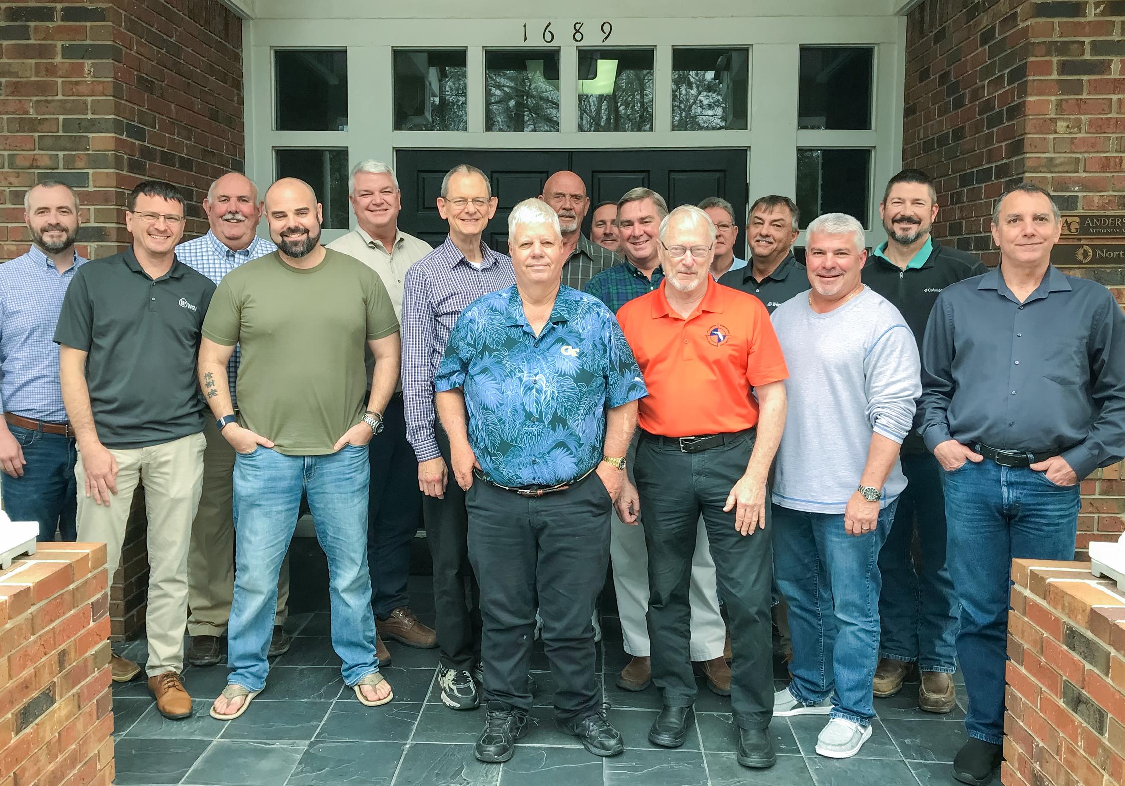
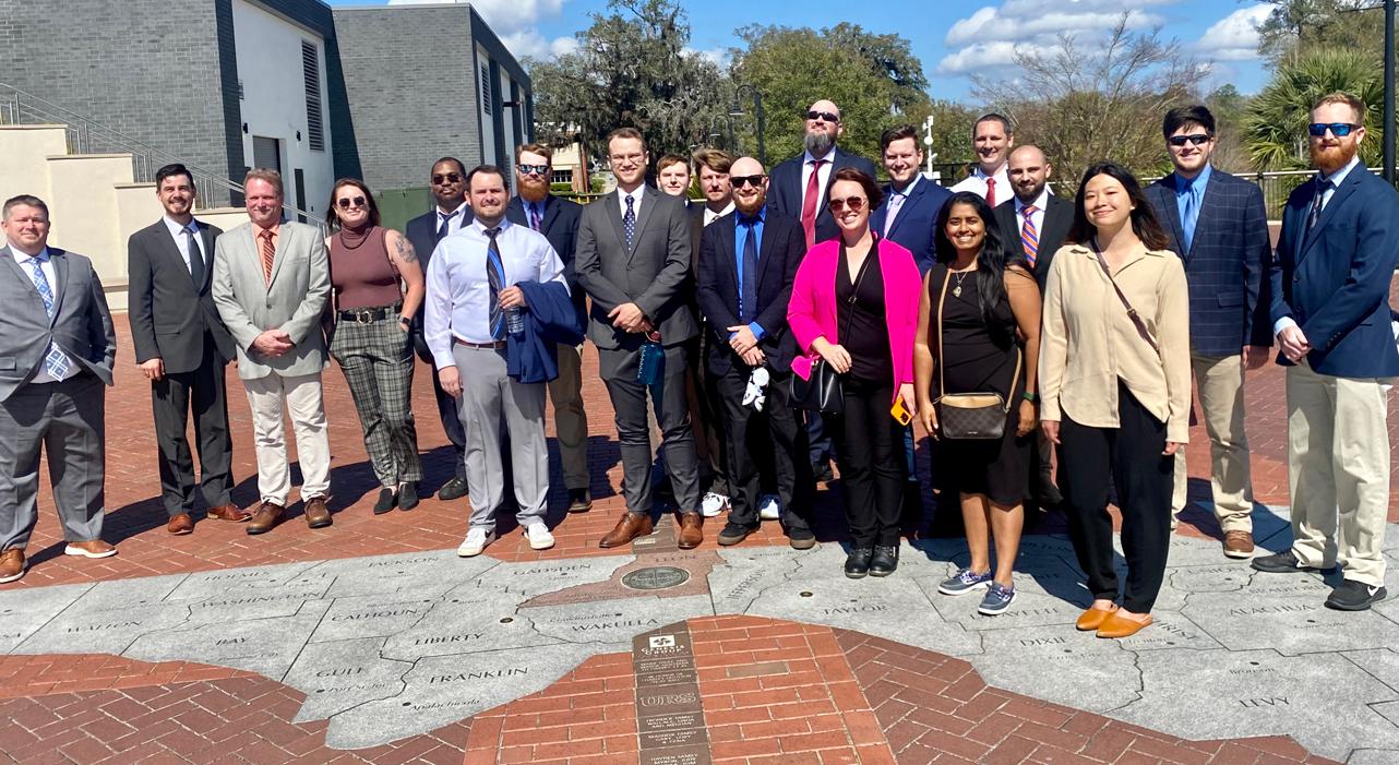
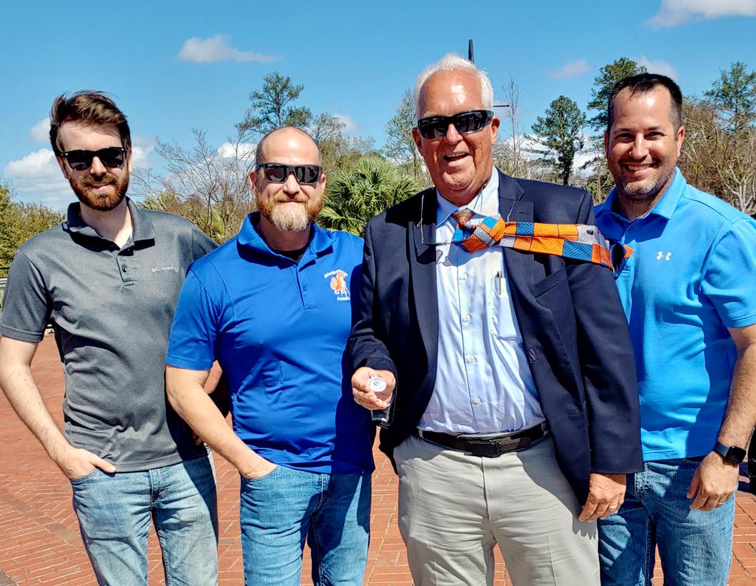
Congratulations to our FSMS 2023 Board of Directors!
This photo was taken after our board meeting in February, and we would like to Thank You all for your time and dedication to our wonderful profession.
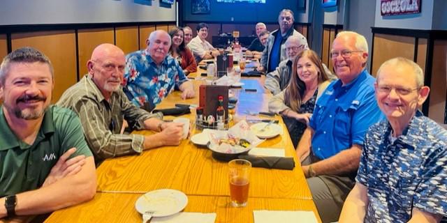
Thursday night's dinner prior to the Friday morning board meeting.
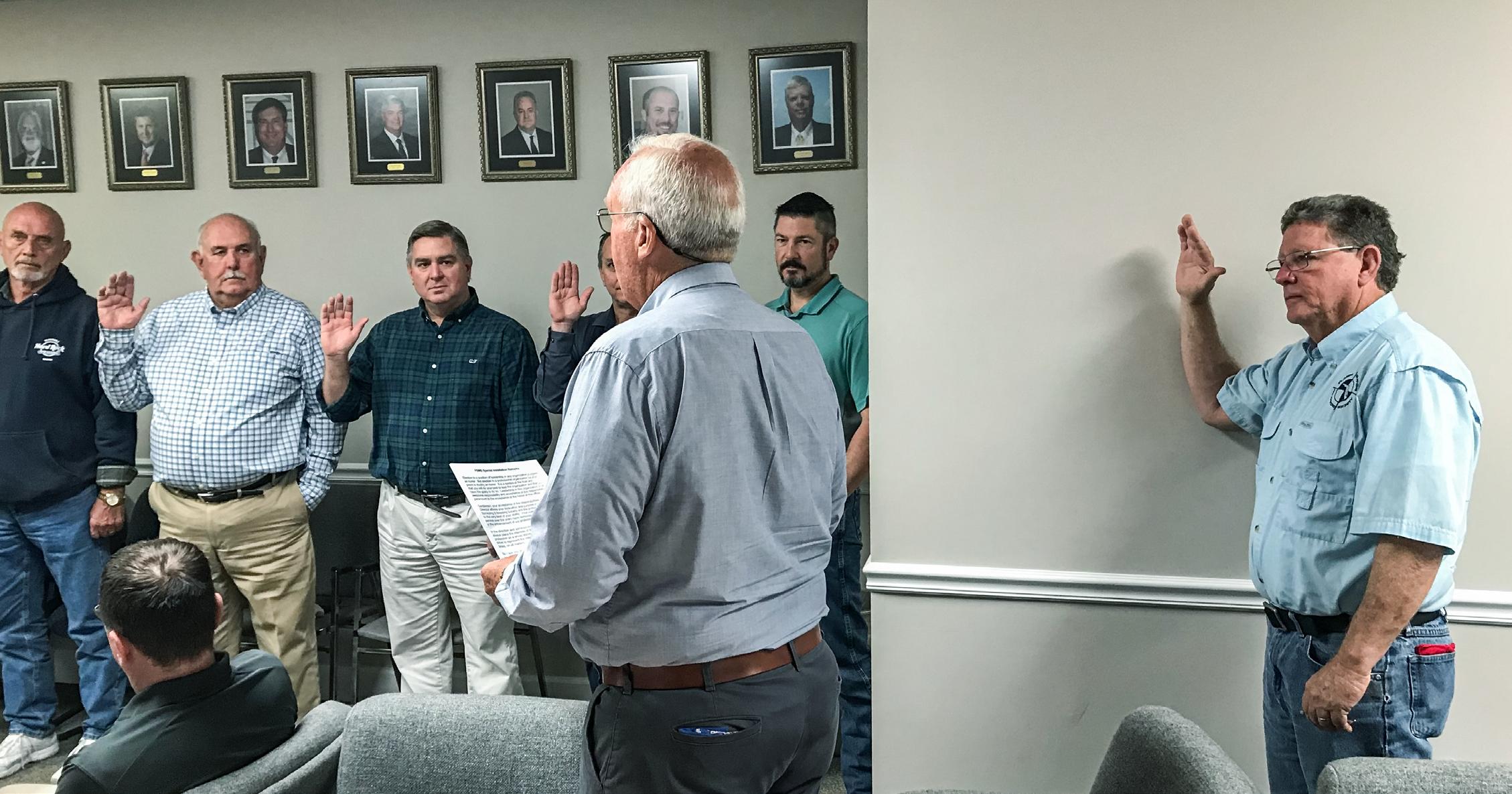
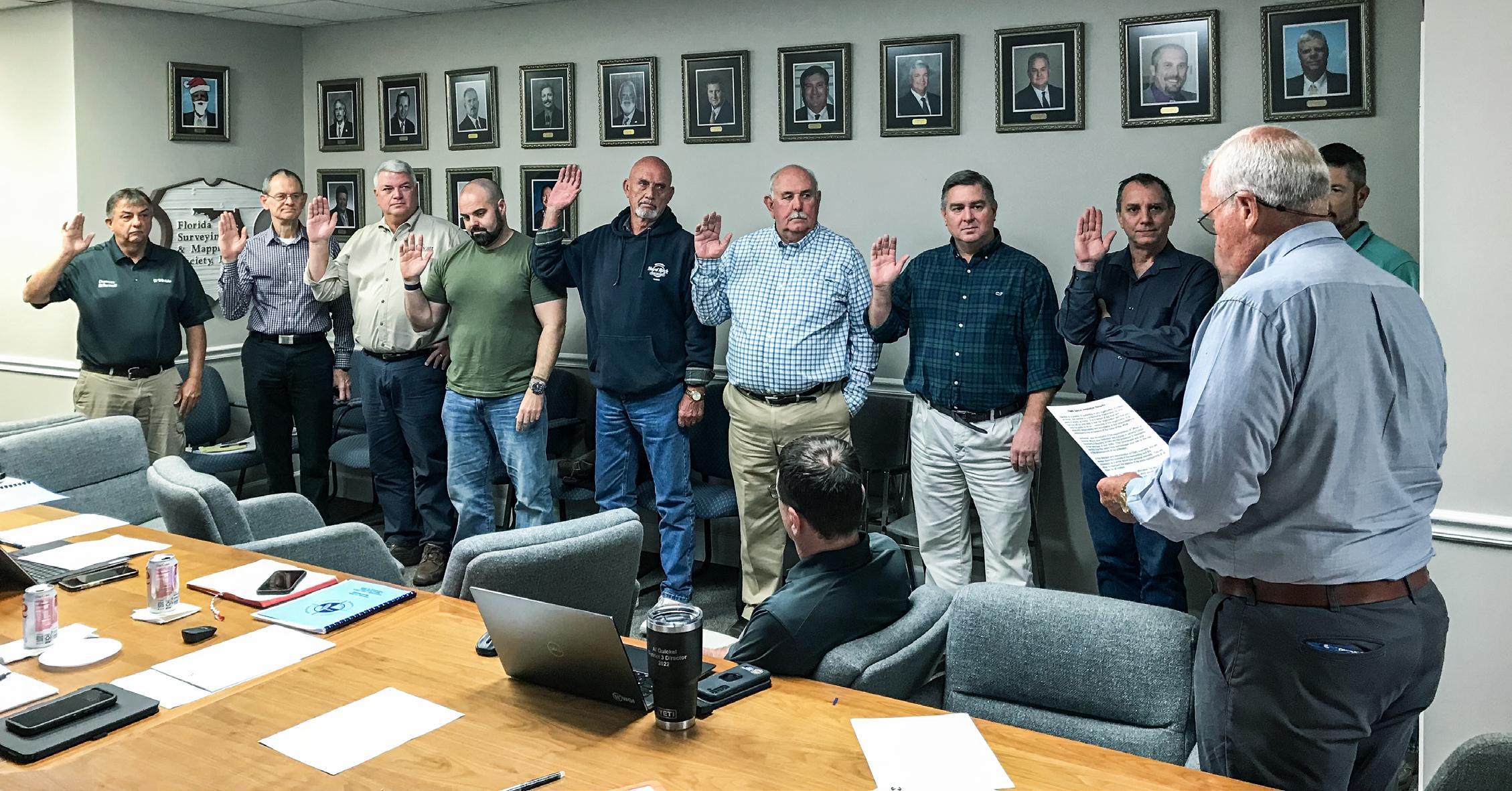
 Swearing-In Ceremony for the 2023 Board of Directors.
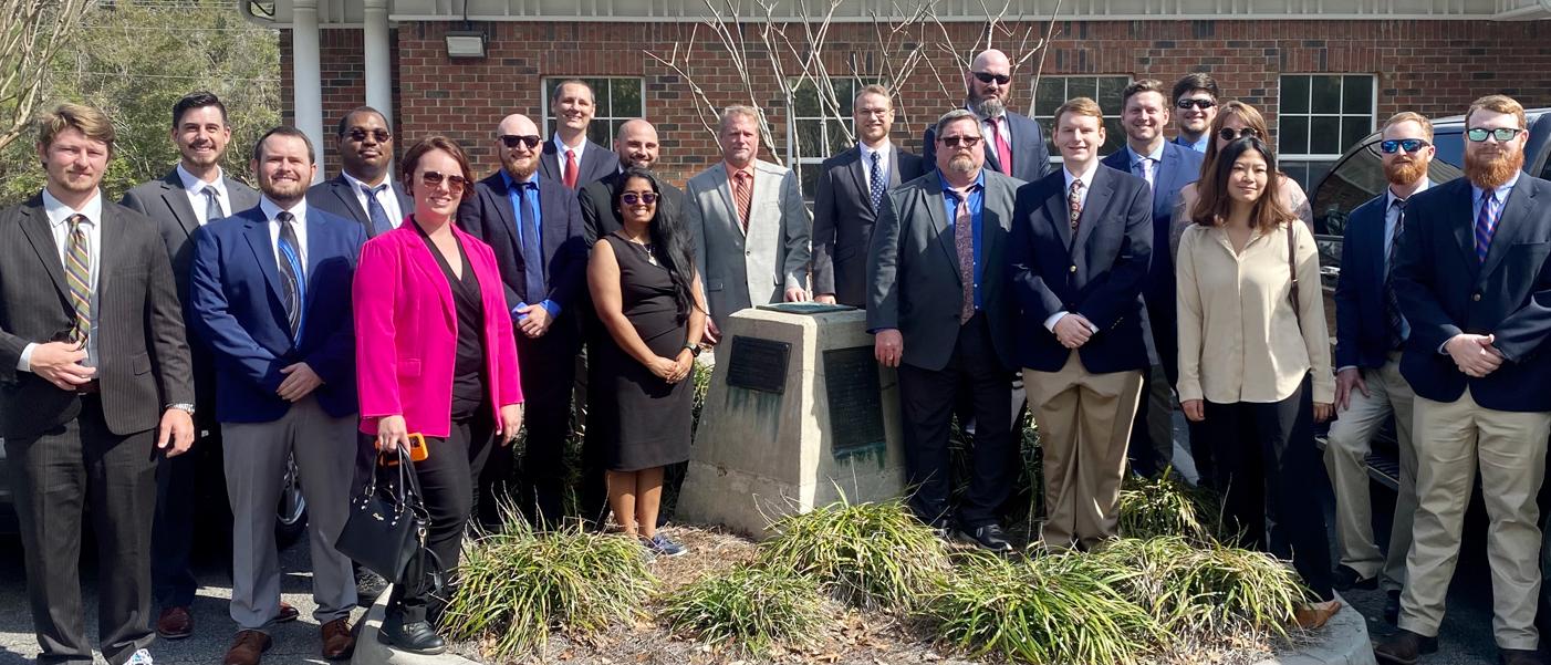
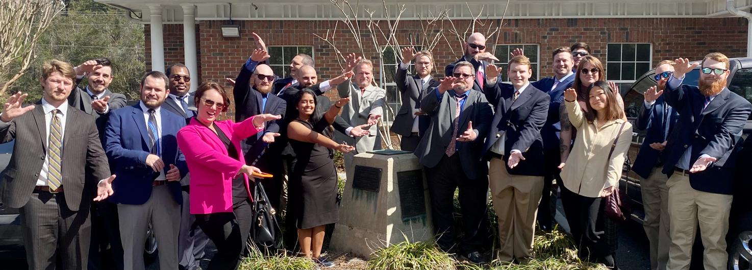
 2023 University of Florida Geomatics Seniors!
It was an honor to host this next generation of land surveyors.
We look forward to all you will accomplish in the future for the profession.
Good luck and Godspeed.
FSMS will be an Exhibitor at the FIG Conference in May and we’re looking for any interesting surveying photos to showcase at our booth. This is a chance to tell a story to the world of what surveying in Florida has looked like throughout the years. If interested, please send your photos to communications@fsms.org.
ARCHIVES FROM THE


The Florida Surveyor Page 51
The following is a transcription of a document by William Roy Bandy. The original, a typewritten carbon copy, was found in the materials sent to Glenn Borkenhagen by Bandy’s grandson Dirk Reith during August 2019. It has not been determined which article it was to precede.
INTRODUCTION to an article following
We have all read numerous exciting stories about how the glorious West was won by the hardy pioneer prospectors and home-seekers who early migrated into the great unknown wilderness seeking home and fortune. However, little has been said about the all important role played by the plodding Government Land Surveyors who also worked their way westward surveying that land so the settlers following them could obtain title to tracts of it for their very own.
This rush westward all began with the acquisition of the first big block of public domain land by our young nation in 1783 with the purchase of the Northwest Territory. Obtaining this undeveloped land by the Federal Government presented an urgent need for a practical, comprehensive system of surveys whereby it might be marked off into tracts suitable in size for disposition to prospective settlers. To meet this demand, none other than our own Thomas Jefferson arose to the occasion, and in consultation with that experienced and famous land surveyor, George Washington, and with other prominent leaders of the day invented and initiated our present Rectangular System of Public Land Surveys, which has so admirably served its purpose over the years. This simple and fool-proof system, often referred to as the best in the world is described briefly as follows:
“That the land be divided into townships six miles square; each township containing thirty-six sections one mile square bounded by lines running in cardinal directions. Provision was also made for subdividing the sections into aliquot parts, even down to square tracts containing only two and one-half acres each if desirable. Permanent corners were to be established at half-mile intervals around each section.”
Armed with this plan in detail the Government Land Surveyors working under instructions from the U.S. General Land Office began their arduous task of executing those surveys where most needed beginning at the Ohio River. The importance of this survey is seen when one learns that title to each and every acre of land in private ownership in the states covered by this rectangular system of survey, from the largest ranch to the small town lot is based upon a plat of this Government Survey.
Since this wild and untrodden land must be surveyed before title could pass to private parties it is evident that the Government surveyors must keep far ahead of the settler. He thus became the real pioneer, and in some instances a sort of explorer. Always in the vanguard, he often must blaze new trails far beyond the settled communities. Leading a nomadic life, often living off the country, the tent was his home, and blankets rolled out on the ground his bed. Used to roughing it, he was lulled to sleep by the coyote’s song, and awakened early by the cheerful call of the friendly meadow lark. Shod with hobnailed boots, carrying a canteen of water, with a sandwich tied to their belts, the crew members were prepared to surmount every obstacle. Obstacles were not uncommon for the section lines must be run straight, leaving no chance for the surveyman to pick an easier way around a cliff, or across a canyon. However, to bolster up his morale he could always look forward to seeing a brand new landscape as he topped ever y hill. Even the most forbidding badlands are beautiful when their multicolored, jagged slopes are viewed from the shaded sanctuary of a stunted pine.
DID YOU KNOW?
There was A hidden corridor inside the Great Pyramid of Giza that was discovered by researches from the Scan Pyramids project. A hidden corridor nine metres (30 feet) long has been discovered close to the main entrance of the 4,500-year-old Great Pyramid of Giza, and this could lead to further discoveries. The Scan Pyramids project has been using non-invasive technology including infrared thermography, 3D simulations, and cosmicray imaging to peer inside the structure.
Source
March 2023 Page 54
Scientists reveal hidden corridor in Great Pyramid of Giza.
PUBLIC LAND SURVEYS • HISTORY AND ACCOMPLISHMENTS
by W illiam R. B andy
Iam pleased to have this opportunity to speak to you on the subject of the Rectangular System of public land surveys. As an employee of the Bureau of Land Management my work deals entirely with the survey of the public lands, and I am happy to discuss with you briefly the history and accomplishments of that field of activity in the United States. The scheme was not something that was just thought of on the spur of the moment, so to speak, but was the result of much thinking, and after the different colonies had tried out many systems. I will outline some of the events leading up over the many years to the formation of the final details of the system, and to its adoption by the Continental Congress in the Land Ordinance of May 20, 1785.
It is safe to say that relatively few people realize and appreciate the importance of the rectangular system of public land surveys in the settlement and development of the vast public domain. Even less is known of the basic contribution it has made to our political and economical advancement. Like many of the advantages we enjoy, it has been accepted as an obvious thing, whose benefits, if considered at all, now appear so self-evident that seemingly no other course could have been followed. But when this survey scheme was established by the Continental Congress, no other counterpart or pattern for it existed. The plan, as developed, was unique in three respects: First it introduced the new principle of “ survey before settlement; ” second, it introduced the concept of a mathematically designed and nationally integrated cadastral survey; and third, it created a standard land unit, the section, of uniform shape and area and with boundaries physically marked on the ground.
It might well be considered why this scheme was developed and where it was applied.
With the founding of the Republic, the colonies ceded their western lands to the central government in order that funds might be realized for payment of the cost of the Revolutionary War and to provide lands to reward the soldiers of the war. This nucleus of the public domain embraced the very large area north of the Ohio River, extending from the west boundary of Pennsylvania to the Mississippi River, and the
The Florida Surveyor Page 55
lands from the west boundary of Georgia to that river. It was for the management of this area that the scheme of the rectangular system of public land surveys was conceived.
During the first 75 years of our national existence there were added to the public domain, areas in the Louisiana Purchase in 1803, the Florida cession in 1819, the Annexation of Texas in 1845, the Oregon Territory in 1846, the Mexican Cession in 1848, and the Gadsden Purchase in 1853. At its greatest extent, the public domain embraced 1,441,346,560 acres, or more than 2,255,000 square miles, representing approximately 75 percent of the area of the continental United States. This domain included the States of Florida, Alabama, Mississippi, and all States north and west of the Ohio and Mississippi Rivers except Texas. The acquisition of Alaska in 1867 added 365,481,600 acres to the public domain. It is this tremendous area, totaling more than 1 billion 800 million acres, which constitutes the field of application of the rectangular system of public land surveys.
As to the factors which prompted the development of an orderly scheme for the survey and disposal of the public domain, it may be pointed out that the American colonists coming from the Old World countries were imbued with the concept of America as a New World. Here land was plentiful and easily obtainable. They were not inclined to forget the oppressive land tenure practices of the Old World feudal systems. From the earliest days there was an indicated intention for security of freehold titles in the individual. The dissatisfaction with the old order of indiscriminate and random division of lands was also manifest early in Colonial Times. One writer says of this phenomenon of attempting regularity of land partition in a world where such orderliness was unknown, “ So early were the common lands thus laid out by men who had, up to that time, been familiar with the irregular method, that it seems as if the plan must have been one of the first products of the new American environment. Under the stimulus of unlimited area and an untouched soil, the newcomers at once improved the old system of dividing land. ”
The New England “ Town Commons ” were generally arranged in regular form and subsequent “ pitches ” or land claims in these organized areas tended to conform to the regular plan of the original layout. In the outlying areas also, an effort was made toward regular and uniform shapes of land disposals. As an example there may be cited a Maryland warrant of March 7, 1641 which directed the surveyor to “ … lay out four thousand acres of land … and bound it with the most natural bounds as near you may to the form of a parallelogram. ”
March 2023 Page 56
The trend toward regularity and uniformity in land disposals was incorporated into the laws of some of the Colonies in the purchase regulations of the large Proprietors such as William Penn, Lord Baltimore, and the Earl of Shaftesbury of the Carolinas, and in the warrants for surveys of most Colonies. The early warrants of Penn instructed the surveyor to lay out the lands “ according to methods of townships appointed by the Proprietors. ” Lord Baltimore directed the lands to be laid out in regular order.
Unfortunately these reasonable requirements were almost completely disregarded except in New England. There the grants tended with time to become more square and of a uniform size. Although directives existed in nearly all of the Colonies for the systematic layout of lands, the results were negligible except in New England. It seems that, while the virtues of land boundary regularity were recognized by our forefathers, they chose to exercise the most novel of their new freedoms—-the right to pick and choose for themselves.
As attractive as this freedom of choice—free from all regulatory restraints—might appear to the settler, in time it created a situation of confusion, conflict, and controversy as to land boundaries and ownership.
In 1699 the House of Assembly of Maryland passed “ an act ascertaining the bounds of land; ” this was an early attempt to rectify the problem caused by unsatisfactory settlement practices. Boundary locations were a problem, but the greatest concern was the excess of land in the grants over the quantity called for in the warrants. Apparently there was seldom a deficiency. The surveyor was blamed for this and possibly rightly so, but you can readily visualize a claimant (who was also the employer) pointing out to the surveyor the bounds of the land he wanted surveyed. The surveyor had little alternative but to survey the lands in accordance with the selection of his employer.
An indication of the confusion which existed at that time may be gained from this act of the Maryland Assembly of 1699, which states in part, “ Whereas, at the first taking up of lands in this Province, necessity constrained His Lordship to commissionate such persons to be surveyors as was but very meanly skillful in the art of surveying; … and the said bounds are generally expressed in such uncertain terms, and being many times contradictions and inconsistent in themselves, whereby it comes to pass that at this time is very uncertain and many chargeable and tedious suits in law happen about such bounds, which are most times (as it were) by the favour and inclination of jurors arbitrarily determined differing ways in
The Florida Surveyor Page 57
Public Land Surveys History and Accomplishments

parallel cases. ” In 1715 a five-man commission was set up to hear and determine all differences and controversies in the matter of land boundaries. They had broad powers of subpoena and could hire surveyors who in cases of minor retracements “ shall have only a quarter of a pound of tobacco per perch and no more. ”
Even earlier, in 1661-1662, the General Assembly of Virginia in connection with a bill providing for “ processioning ” said, “ many contentious suits are daily incited and stirred up about bounds of land for which no remedy hath yet been provided. ” By 1705 they were forced to come to grips with the problem and passed “ an act concerning the granting, seating, and planting and for settling the titles and bounds of lands. ”
This gives an indication of conditions which created a basic demand for the development of an orderly plan for survey and settlement of the public lands in the Western Territory.
In 1784 a Commission of the Continental Congress, of which Thomas Jefferson was chairman, reported an ordinance for the mode of locating and disposing of the lands in the Western Territory. This was considered and discussed at length. As amended and adopted by The Congress on May 20, 1785, it became the foundation on which was built the structure of the survey of the public lands.
This land ordinance provided for the survey of the Territory into townships, six miles square, by lines running due north and south and others crossing those at right angles. The ordinance further specified that “ the lines shall be measured with a chain; shall be plainly marked by chaps on trees and exactly described on a plat; whereon shall be noted by the surveyor, at their proper distances, all mines, salt springs, salt licks, and mill seats that shall come to his knowledge; and all water courses, mountains and other remarkable and permanent things over and near which such lines shall pass; and also the quality of the lands. ” The ordinance also provided that “ the plats of the townships, respectively, shall be marked by subdivisions into lots of one mile square, or 640 acres, in the same direction as the external lines, and numbered from 1 to 36. ” The surveys were directed to be made by a corps of surveyors, one from each State, to operate under the direction of the Geographer of the United States, a position held by Thomas Hutchins. The Geographer was directed to “ personally attend to the running of the first east and west line and shall take the latitudes of the extremes of the fi rst north and south lines and of the principal rivers. ”
The Florida Surveyor Page 59
Public Land Surveys History and Accomplishments
The surveys under this act were known as “ the seven ranges ” in Ohio. The first township surveyed under this ordinance is in what is now Jefferson County in the vicinity of Steubenville, Ohio; the survey was executed in 1786 by Absalom Martin of New Jersey.
Late in 1785, Thomas Hutchins submitted to the President of the Continental Congress “ a plan and remarks of that part of the Western Territory through which an east and west line has been run. ” The east and west line which he ran extended only four miles westward from the intersection of the Pennsylvania boundary with the Ohio River but his notes covered eight closely written pages in describing the slopes, soil, trees, and even medicinal herbs along the way. This established a pattern for reporting the character of the land, soil and timber which has been followed in the survey of the public lands from that time to the present, though probably the detail given in the Hutchins report has not since been equaled.
The administration of the public lands at that time was under the Treasury Department of the Federal Government. In 1790 Alexander Hamilton, Secretary of the Treasury, submitted a report to Congress on the administration of the public lands. He proposed the establishment of a General Land Office in the Treasury Department and that a Surveyor General be in charge of the public land surveys, with a corps of deputy surveyors to execute the surveys. His recommendations were not acted upon immediately and, after much delay, only in installments.
Some of those recommendations were incorporated in the act of May 18, 1796, which provided “ that a Surveyor General shall be appointed whose duty it shall be to engage a sufficient number of skillful surveyors as his deputies whom he shall cause, without delay, to survey and mark the unascertained outlines of the lands lying north west of the River Ohio and above the mouth of the River Kentucky, in which the titles of the Indian tribes have been extinguished, and to divide the same in the manner herein after directed. ” This act went on to provide for the subdivision of the Territory into townships much the same as in the land ordinance of 1785. The act also required that “ the corners of the townships shall be marked with progressive numbers from the beginning; each distance of a mile between said corners shall also be marked with marks different from those of the corners. Half of the said townships, taking them alternately, shall be subdivided into sections, containing as nearly as may be, 640 acres each, by run ning through the same each way parallel lines at the end of every two miles, and by marking a corner on each of said lines at the end of every mile. ” The act also provided that all of the lines were to be measured with chains containing two perches of 16½
March 2023 Page 60
W illiam R. B andy
feet each and for the marking of witness or bearing trees at each corner location.
This is the first reference to a section as the unit of subdivision of the township and is also the first statutory requirement for the physical establishment of corners on the boundaries of the township and sections. Other early laws providing for the survey of the public lands were the acts of May 10, 1800; February 11, 1805; and April 25, 1812. However, the land ordinance of 1785 and the act of 1796 are considered to have established the basic principles in our surveys of the public lands; on these two acts hang all the laws and the prophets so far as public land surveys are concerned.
The act of May 10, 1800 provided for the running of section lines at intervals of one mile and the establishment of quarter–section corners. The finality of the surveys was guaranteed by the act of February 11, 1805, which provided that:
l. All of the corners marked in the surveys returned by the Surveyor General shall be established as the proper corners of the sections or subdivisions of sections which they were intended to designate.
2. The boundaries actually run and marked in the surveys returned by the Surveyor General shall be established as the proper boundary lines of the sections or subdivisions for which they were intended, and the lengths of such lines as returned in the surveys shall be held as the true lengths thereof.
3. Each section or subdivision of section shall be held and considered to contain the exact quantity of land returned in the survey.
Rufus Putnam was the first Surveyor General under the act of 1796. He served from 1797 to 1803, followed by Jared Mansfield, Josiah Meigs, and Edward Tiffin. That part of the Northwest Territory which became the state of Ohio was the experimental ground for the development of the rectangular survey system. Here the plans and methods were tested in a practical way and notable revisions in the rules and practices, based on the earlier experiences, were made applicable as the surveys progressed westward until the plan became perfected. Much credit must be given to the work of the early Surveyors General in developing and perfecting the plan of surveys. During their incumbency in office, the surveys in Ohio were largely completed and the work had been extended into Indiana and southern Michigan.
The adoption of the rectangular system marked the transition from the surveying practice prevailing in the greater part of the colonial states where land grants
The Florida Surveyor Page 61
Public Land Surveys History and Accomplishments
were defined by irregular metes and bounds, each depending more or less on the description of an adjoining tract, which was known by name or number, and mostly without common geographic location other than a possible reference to some wellknown natural object.
The general plan of the rectangular system of public land surveys is well known, particularly in the portions of the United States over which it has been extended. Its importance in our history is such that many high school textbooks describe its features and advantages. No attempt will be made here to describe this system in detail. Suffice it to say that the basic unit of survey is the township, six miles square. The next lower unit is the section, one mile square. Since the townships are arranged in a checkerboard pattern, oriented north-south and east-west, which is a coordinate system of construction, each township can be described as so many townships north or south of the base line and so many ranges east or west of the governing principal meridian. The sections are laid out within the township in a systematic manner, beginning with No. 1 in the northeast section and proceeding west and east alternately through the township with progressive numbers to No. 36 in the southeast section. Operational errors are prevented from accumulating and geodetic factors compensated for by the establishment of standard parallels (or correction lines) and guide meridians at stated intervals.
It must be realized that from its inception in 1785 until about the turn of the 20th century, the public land surveys were carried forward in virgin territory—unexplored and unmapped—in advance of settlement. The records of those surveys, consisting of the official plats and descriptive field notes, afforded substantially the only information as to the character of the land and its resources. The field notes, for example, contain the surveyor's estimate of the quality of the soil for each mile surveyed, remarks on the lay of the land and description of vegetation, as well as information on streams, lakes, and ponds. The plats show the lengths and directions of lines and the legal areas of sections and their subdivisions as well as planemetric data such as the streams and lakes and the extent of prairie or swamp land.
Looking back over the history of the westward expansion of this Nation, we must realize that the information afforded by these basic survey records was essential to that expansion and was relied upon by those who purchased the lands in the early days, those who sought agricultural lands under the Homestead Act of 1862, and those in search of timber or other resources of the land.
The rectangular system of public land surveys was extended before settlement. Thus,
March 2023 Page 62
W illiam R. B andy
with every surge of their drive to the frontier, the settlers found that the Government surveyors had been there before them and had neatly blocked out the agricultural land into mile squares, with the boundaries definitely established and marked on the ground.
The history of the development of this country can be traced largely by the timing of the public land surveys. The annual reports of the Commissioner of the General Land Office were for many years accompanied by a map showing the extent of the public land surveys executed to the date of the report. It is fascinating to follow the progress of those surveys and to picture the development of the country which followed.
By the 1860's, the surveys had been extended across the Mississippi and embraced practically all of Louisiana, Arkansas, Missouri, Iowa, and southern Minnesota; you will also find that large areas in California and Oregon had been surveyed to accommodate the settlement following the gold rush of 1849 and the migration to the Oregon Territory. The map accompanying the report of 1865 shows surveys in eastern Kansas and Nebraska and along the old Santa Fe Trail in New Mexico in advance of settlement in that area, and in a very small portion of Colorado to accommodate the settlement after the discovery of gold and silver in the Cripple Creek area. That map also shows limited surveys in Utah to accommodate the influx of the Mormons. Vast areas comprising the Dakotas, Montana, Idaho, Wyoming, Nevada, much of Kansas, Nebraska, Colorado, Utah, New Mexico, and all of Oklahoma (then Indian Territory) and Arizona were entirely unsurveyed at that time.
Prior to 1910, the public land surveys were executed by a corps of deputy surveyors who operated under negotiated contracts at a price from about $2 to $8 a mile.
By act of Congress the contract system of surveys was abolished in 1910 and since that time the work has been carried on by a corps of cadastral surveyors on the Federal payroll. The reason for the change from the contract system to the direct employment system was largely the fact that the remaining unsurveyed public lands were relatively scattered and in small blocks in difficult terrain. Difficulty was experienced in contracting for the work at the rates allowed by law. Coupled with this there was the necessity for resurveys occasioned by the disappearance of the corner monuments due to the lapse of time and ravages of the elements which involved the protection of the vested rights of those who had acquired title to lands through operation of the public land laws. This created conditions beyond the capabilities of the average contract surveyor and necessitated the development and training of a corps of specialized surveyors to handle the problems.
The Florida Surveyor Page 63
Public Land Surveys History and Accomplishments
By the time of the conversion of the contract to the direct system, much of the arable land area and the areas for which need could be foreseen, had been surveyed. As might be expected from a program of this magnitude, which extended over a period of more than 120 years and stretched from the Appalachian Mountains to the Pacific Ocean and from Canada to the Gulf of Mexico, some irregularities had crept in. Undoubtedly, some of the reported surveys in the rougher and more remote regions were more or less fraudulent. However, surveys of that character are but an infinitesimal portion of the total and cannot be permitted to influence the judgment as to the accuracy and integrity of those men who braved the wilderness in the early days of the history of this country for the purpose of creating land boundaries to enhance and speed the development of the Nation.
Under the contract system, the corner position monumentation was by the most durable native material available. This could have been marked stones, stakes, living trees, or other material thought to be adequate for the purpose. Such monuments are subject to deterioration and disappearance through natural causes. In many cases the surveys were made years and years in advance of settlement or before the land became economically desirable for other purposes. During that lapse, much could and did happen in the way of destruction of the corner monuments. I am convinced that in many cases the charge of fraudulent survey has been incorrectly made whereas, in reality, the absence of identifiable corners is due to the lapse of time since the survey was executed.
Since 1910 the survey corners have been monumented with wrought iron galvanized posts having a brass cap on which the corner marks are stamped. It is the expectation that, with the exception of areas of the most adverse soil conditions, this type of corner monumentation will last for 100 years or more. I may say, however, that we have not abandoned thought of an even more permanent corner marker and are continuing our search for suitable material.
An important economic advantage of the rectangular scheme of surveys is that the lands are ordinarily disposed of in square units or legal subdivisions of 40 acres each. The land record in the counties of the public land States can thus be entered easily and maintained on printed and uniform size diagram of township plats. The title records are much more complicated and involved in the older areas where the records must be compiled from innumerable irregular and uncoordinated survey records.
From the standpoint of land economics, the disposal of land in blocks, which
March 2023 Page 64
W illiam R. B andy
entailed the taking of the bad with the good, has resulted in the highest land use of the whole. This was a bitterly-opposed feature of the original land ordinance and the wisdom of the course was slow to be appreciated. Naturally the settler wanted all of his holdings to be good land and objected to having what he considered as worthless hills, swamps, or poor land included in his settlement. However, experience has proven that, once it was his, he has made every effort to utilize it all to the best advantage—the hills have become woodlands and pasture; the swamps and sloughs have been drained or filled, where possible; and the rocky or poorer land may have been used as home or barn sites. With the settlement of the country and increasing value of the land, new uses and new demands have been made for even the scattered and isolated tracts of unattractive land in the areas of the earliest settlement. As a result, much land that once had only marginal economic value has been transferred to private ownership in units of manageable size and character, thus eliminating the endless administrative problems incident to Federal management of those scattered tracts.
You will recall that the 1805 act established the finality of the corners and lines of the public land surveys. As a result, in spite of the intense development of much of the area covered by those surveys, the lines and corners are still preserved as corners and boundaries of the privately owned land. This is demonstrated emphatically in air travel over the agricultural areas of the Midwest where the fields still conform to the lines of the early surveys. Even in such metropolitan areas as Chicago, the townsite subdivision is controlled by the section lines of the original public land surveys— streets are laid out along those lines and the public land survey corners have been perpetuated and buried beneath the pavements.
As to accomplishments, I have indicated that the rectangular public land surveys have been extended over the public lands from the Appalachian Mountains to the Pacific coast and from the Canadian border to the Gulf of Mexico. Statistically, approximately 1 billion 330 million acres in the continental United states have been surveyed. Only a very small portion of Alaska has been surveyed but the surveys in that Territory are being extended as rapidly as necessary to anticipate the needs of settlement and industry.
The present corps of cadastral surveyors in the Bureau of Land Management is engaged principally in the execution of three classes of surveys in the continental United States:
1. The execution of original surveys in regions so fantastically rough and broken
The Florida Surveyor Page 65
Public Land Surveys History and Accomplishments
that until the discovery of uranium and petroleum in relatively recent years, it was not believed that there would ever be a need for their survey. In some of these areas it is necessary to transport survey crews by helicopter in order to accomplish the required surveys.
2. The resurvey of early surveys and identification of the boundaries of remaining public lands for the proper administration of those lands which have become increasingly valuable with the settlement and development of the country.
3. The resurvey and remonumentation of the boundaries of areas subject to intensive development—-such as reclamation projects.
There are large areas of unsurveyed public lands included in permanent reservations, such as National Forests and National Parks, in which the extension of the public land surveys probably never will be required. However, there are some 175 million acres of public lands still under the jurisdiction of the Bureau of Land Management. It is estimated that much of this area will require resurvey to permit effectual management of the land and resources. There are very extensive areas where, due to deterioration of corner monuments, there is uncertainty as to position of boundaries between Federal and privately owned lands, wherein the services of our surveying organization are urgently needed to settle matters of trespass. While it is improbable that all of Alaska will require survey, there are very extensive areas suitable for settlement and development in that Territory which must be surveyed to develop their full potentialities. All of these mount up to a very considerable program of survey and resurvey of the public lands which will require many years for completion.
Looking back over the years, one who has been closely connected with the public land survey system cannot help but admire those who conceived the plan and put it into operation. The names of many, such as Hutchins, Mansfield, Meigs, Tiffin, Freeman, Ellicott, William Burt and his four sons, come to mind as those who have contributed so largely to the successful inauguration and prosecution of this system. Designed originally to mark on the ground the boundaries of tracts of land for purposes of settlement and development of the wilderness, the public land survey system of the United States has been and is a marked success.
March 2023 Page 66
W illiam R. B andy
2023 eLearning Courses
6 General CEC - $99/course (members)
$120/course (non-members)
• History of Surveying
- Course #7140
• Identification of Native & Non-Native Trees in Florida
- Course #8132
• Ethics for the Design Professional
- Course #8621
• Land Tenure & Cadastral Systems
- Course #8260
• Map Projections & Plane Coordinate Systems - Course #8261
• Public Land Survey System
- Course #7147
• Remote Sensing Applications to Surveying & Mapping
- Course #7148
• Practical Geometry for Surveyors
- Course #7141
3 General CEC - $49/course (members)
$70/course (non-members)
• Basics of Real Property
- Course #8360
• Elevation Certificates & the Community Rating System
- Course #8256
• Introduction to Photogrammetry
- Course #7968
• Writing Boundary Descriptions
- Course #8362
The Florida Surveyor Page 67
Florida Surveying & Mapping Society 1689 Mahan Center Blvd. Suite A Tallahassee, FL 32308 www.fsms.org (850) 942-1900
Florida Surveying and Mapping Continuing Education Provider Offering 25 Years of Dedication, Quality & Trusted Services
Step 1: Choose Course(s)
3 Hour Courses Available
□ A History of the Prime Meridian Marker,
□ Basics of Real Property
□ Digital Signatures for Surveyors
□ Easements and Rights of Ways,
□ Elevation Cert
□ Introduction to Photogrammet
*2020 UPDATED COURSE
□ Quality Assurance/Quality Cont , #9293, 3 CEC
□ Writing Boundary Descriptions
6 Hour Courses
□ Boundaries in Florida
□ Chapter 177, Platting (Plat Law)
□ Critical Communication for Surveying & Mapping Professionals
□ Ethics for the Design Professional
□ Florida Laws
□ Florida Surveying Law and Rule Changes
□ Geographic Information Systems (GIS)
□ History of Surveying,
□ Identification of Native and Non-Native Trees in Florida
□ Land Tenure and Cadastral Systems
□ Map Projections and Plane Coordinate Systems , #7669, 6 CEC
□ Practical Geometry for Surveyors, #7109, 6 CEC
□ Public Land Survey System, #6979, 6 CEC
□ Remote Sensing Applications to Surveying & Mapping, #6972, 6 CEC
*2020 UPDATED COURSE
March 2023 Page 68
Billing Address of Credit Card:
IF PAYING BY CHECK, MAIL FORM TO: FSMS, P.O. Box 850001-243, Orlando, Florida 32885-0243
IF PAYING BY CREDIT CARD, FAX OR EMAIL FORM TO: 850.877.4852 education@fsms.org QUESTIONS? CALL 800.237.4384
The Florida Surveyor Page 69 Step
FSMS Member EMAILED Fee Quantity Amount 6 CEC $115 Per Course x = $ 3 CEC $58 Per Course x = $ MAILED 6 CEC $125 Per Course x = $ 3 CEC $68 Per Course x = $ TOTAL $ Non Non Name: _ YES _ NO Firm: ____ _ YES _ _ NO Address: ______________________________________________________________________________________ City/State: Email Address: Work Phone: Payment
to FSMS) _ VISA/MasterCard/American Express Card
Exp. Date: __ CVV Code:___________
2: Choose Member Type
Information: ___ Check Enclosed (Payable
#: _______
______________________________________ Signature: _____________________________________ __
Provider No. CE11 fsms.org
SUPER EARTH S?


March 2023 Page 70
LAND WATER
With the help of Frontier Precision, places you once couldn’t imagine measuring are now a daily reality. Frontier Precision leads the way in Unmanned technology – through the air, land, and underwater. Every place on earth is now reachable – with UAS from DJI, Autel, Parrot, Ascent, and ROVs, Pipe Crawlers, and Utility Crawler solutions from Deep Trekker. Count on us to deliver the latest technology to help you get your job done e ciently and accurately while driving your profits. Today, no mission is out of reach.


8301
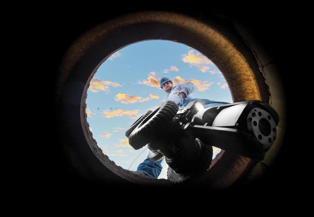
FRONTIER PRECISION
JACKSONVILLE
|
Cyprus Plaza Drive,
FIND OU T M O RE A T : W W W .FRO N T IE RPRE C IS I ON.CO M / U N M A NN E D P R O DUCTS | T R AINING | RE PAIR | REN TA L S | T ECHNI C A L SE R VICE S AIR
#107 Jacksonville, FL 32256
A Grant Funding Opportunity is Now Available!
The National Geodetic Survey released a competitive funding opportunity under the Geospatial Modeling Grant. The Funding Opportunity is available for application through Grants.gov - https://www.grants.gov/web/grants/view-opportunity.html?oppId=346302. Please review the “related documents” tab and download the full Notification of Funding Opportunity titled “NOAA-NOS-NGS-2023-2007815 NOFO Report.pdf.” This document describes the application requirements.

Description of Funding Opportunity
The primary objective of this funding opportunity is to modernize and improve the National Spatial Reference System (NSRS) and address emerging research problems in the field of geodesy. The secondary objective of this funding opportunity is to support a Geodesy Community of Practice in collaboration with federal and nonfederal stakeholders to address the nationwide deficiency of geodesists and improve the coordination and use of geospatial data. The program priorities under this grant program include:
1. Research and develop new methodologies for defining and applications for working with the NSRS;
2. Develop and evaluate tools, models, and guidelines to access, analyze, and manipulate geodetic data;
3. Enhance infrastructure of geodetic control, coastal remote sensing data, survey measurements, and other physical datasets that comprise the NSRS;
4. Support education, capacity building, and technology transfer for the future of geodesy; and
5. Coordinate through partnerships with local, state, and regional users (e.g. state and local governments, universities, and/or the public sector).
Eligibility
Eligible funding applicants for this competition are institutions of higher education, state, local and Indian tribal governments.
Are You Registered to Receive a Federal Grant Award?
Any applicant awarded in response to this Announcement will be required to use the System for Award Management (SAM), which may be accessed online at https://sam. gov/SAM/. Applicants should allow a minimum of two weeks to complete the SAM registration; registration is required only once but must be periodically renewed. On April 4, 2022, the federal government began using a new Unique Entity Identifier (UEI) number provided by SAM. Your organization’s Employer Identification Number (EIN) will be needed to receive a UEI, which is provided by SAM. If your entity is already registered in SAM.gov, your new UEI has already been assigned and is viewable in SAM.gov. This includes inactive registrations.
March 2023 Page 72
Join NGS at the 2023 FIG Working Week in Orlando, Florida
NGS is excited to announce that we will be presenting a full-day’s worth of content on the National Spatial Reference System (NSRS) Modernization during the FIG Working Week 2023 meeting, taking place at the end of May 2023 in Orlando, Florida. For the first time in over 20 years, this annual gathering of the International Federation of Surveyors will be taking place in the United States, hosted by the National Society of Professional Surveyors (NSPS). Click here to register now!

“The International Federation of Surveyors (FIG) is a United Nations and World Bank recognized non-governmental international professional organization. FIG was founded in 1878 and represents national associations of surveying, cadastre, valuation, national mapping professionals, geospatial experts and quantity surveyors working in both the public and private sectors, in the scientific, research and academic community, as well as from technology innovators and industry from more than 120 countries around the world.”
The 2023 Working Week will be an exciting week-long conference that brings the international community of surveying and geospatial professionals together for a mix of technical sessions and workshops, a trade exhibition and a variety of side events and
The Florida Surveyor Page 73
social functions.
On Wednesday, May 31, 2023 , NGS Director Juliana Blackwell will give a keynote address to the full conference and NGS staff will host a series of sessions on our efforts to modernize the U.S. National Spatial Reference System. More information will be posted to the NGS FIG 2023 webpage as it becomes available.

We encourage you to attend as much of the Working Week as you can, and be sure to join us on the Wednesday after Memorial Day to talk to NGS staff about NSRS Modernization.

March 2023 Page 74
Why Join FSMS?
LegisLative support –The Legislative Committee and our Lobbyist are committed to keeping the Public and the Surveying and Mapping Profession protected
educationaL Benefits –With recently updated courses, getting your CECs has never been better
networking –Attend our Annual Conference to meet other professionals and meet vendors with all the latest equipment
sociaL Benefits –Attend local chapter meetings to meet individuals with common professional goals
The Florida Surveyor Page 75 Aug/Sept 2021 30
CLICK HERE TO JOIN! Florida Surveying & Mapping Society 1689 Mahan Center Blvd.
A Tallahassee, FL
www.fsms.org
942-1900
Suite
32308
(850)
Sponsor Name:
SPONSOR APPLICATION
5th Annual
2023 INDIAN RIVER CHAPTER OF FSMS CHARITY CLAY SHOOT
OK CORRAL GUN CLUB
9449 48th Street Northeast, Okeechobee, FL 34972
MAY 6, 2023
OFTEN IMITATED, NEVER DUPLICATED
Sponsorship Level:
Contact:
Email:_____________________________________________________________________________
Phone Number:
Please make check payable to: “Indian River Chapter of FSMS” Mail to:


Indian River Chapter of FSMS
c/o Brion Yancy
BOWMAN
301 SE Ocean Blvd, Suite 301
Stuart, FL 34994
Brion Yancy
Office: 772-678-4340
Cell: 772-475-7475
byancy@bowman.com
Proceeds to support the Wounded Veterans Relief Fund


SPONSORSHIP OPPORTUNITIES
5th Annual
2023 INDIAN RIVER CHAPTER OF FSMS CHARITY CLAY SHOOT
OK CORRAL GUN CLUB
MAY 6, 2023
EVENT SPONSOR $5,000
Includes 4 Teams and 4 carts
VIP CABIN – sleeps 12
Advertisement on all Flyers

Ammo for 16 shooters Station sign
Brion Yancy
Office: 772-678-4340
Cell: 772-475-7475
byancy@bowman.com
Proceeds to support the Wounded Veterans Relief Fund
SPONSORSHIP OPPORTUNITIES
5th Annual
2023 INDIAN RIVER CHAPTER OF FSMS CHARITY CLAY SHOOT OK CORRAL GUN CLUB
MAY 6, 2023
Cart Sponsor: $4,000

Includes 3 Teams and 3 carts
2 CABINS
Ammo for 12 shooters
Sign on all carts
Ammo Sponsor: $2,500
Includes 2 Teams and 2 carts
1 CABIN
Ammo for 8 shooters
Sign with ammo
Brion Yancy
Office: 772-678-4340
Cell: 772-475-7475
byancy@bowman.com
Lunch Sponsor: $2,500
Includes 2 Teams and 2 carts
1 CABIN
Ammo for 8 shooters
Sign at Lunch
Lunch is included with all sponsorship levels
Proceeds to support the Wounded Veterans Relief Fund
SPONSORSHIP OPPORTUNITIES
5th Annual
2023 INDIAN RIVER CHAPTER OF FSMS CHARITY CLAY SHOOT

OK CORRAL GUN CLUB
MAY 6, 2023
Poison Bird Sponsor: $2,500
Includes 2 Teams and 2 carts
1 CABIN
Ammo for 8 shooters
Sign at station
Cabin Sponsor: $2,500


Includes 2 Teams and 2 carts
1 CABIN
Ammo for 8 shooters
Station sign
Brion Yancy
Office: 772-678-4340

Cell: 772-475-7475
byancy@bowman.com
Green Bird Sponsor: $2,500
Includes 2 Teams and 2 carts
1 CABIN
Ammo for 8 shooters
Sign at station
Trophy Sponsor: $2,500
Includes 2 Teams and 2 carts
1 CABIN
Ammo for 8 shooters
Station sign
Lunch is included with all sponsorship levels
Proceeds to support the Wounded Veterans Relief Fund
SPONSORSHIP OPPORTUNITIES
5th Annual
2023 INDIAN RIVER CHAPTER OF FSMS CHARITY CLAY SHOOT OK CORRAL GUN CLUB
MAY 6, 2023
Flurry Sponsor: $2,500
Includes 2 Teams and 2 carts
1 CABIN
Ammo for 8 shooters
Sign at station
Score Card Sponsor: $2,500
Includes 2 Teams and 2 carts
1 CABIN
Ammo for 8 shooters
Station sign
Brion Yancy
Office: 772-678-4340
Cell: 772-475-7475
byancy@bowman.com
Safety Clinic Sponsor: $2,500
Includes 2 Teams and 2 carts
1 CABIN
Ammo for 8 shooters
Station sign
Brochure Sponsor: $2,500
Includes 2 Teams and 2 carts
1 CABIN
Ammo for 8 shooters
Station sign
Lunch is included with all sponsorship levels
Proceeds to support the Wounded Veterans Relief Fund
SPONSORSHIP OPPORTUNITIES
5th Annual
2023 INDIAN RIVER CHAPTER OF FSMS CHARITY CLAY SHOOT OK CORRAL GUN CLUB MAY 6, 2023
Flurry Sponsor: $2,500
Includes 2 Teams and 2 carts
1 CABIN
Ammo for 8 shooters
Sign at station
Raffle Sponsor: $2,500
Includes 2 Teams and 2 carts
1 CABIN
Ammo for 12 shooters
Sign with raffle items
Individual Team: $1,000
Includes 1 Team and 1 cart
Ammo for 4 shooters
Brion Yancy Office: 772-678-4340
Cell: 772-475-7475
byancy@bowman.com
Safety Clinic Sponsor: $2,500
Includes 2 Teams and 2 carts
1 CABIN
Ammo for 8 shooters
Station sign
8 available, yes 8!
Station Sponsor: $250
Sign at one station
Lunch is included with all sponsorship levels
Proceeds to support the Wounded Veterans Relief Fund
PLEASE PRINT
TEAM APPLICATION
5th Annual
2023 INDIAN RIVER CHAPTER OF FSMS CHARITY CLAY SHOOT
OK CORRAL GUN CLUB
MAY 6, 2023
Shooter 1:
Email:
Phone Number:
Shooter 2
Shooter 3
Shooter 4
SHOTGUN START
Please make check payable to: “FSMS Indian River Chapter”
Mail to:
FSMS Indian River Chapter
c/o Brion Yancy
BOWMAN
301 SE Ocean Blvd, Suite 301
Stuart, FL 34994
Brion Yancy
Office: 772-678-4340

Cell: 772-475-7475
byancy@bowman.com
Proceeds to support the Wounded Veterans Relief Fund
4 PERSON TEAM = $1000
INDIVIDUAL = $250
Breakfast, Lunch, AMMO, & Cart Included
ADMINISTRATIVE Staff
Executive Director

Rebecca Porter director@fsms.org

Education Director
Samantha Hobbs education@fsms.org
Communications
Coordinator

Justin Ortiz communications@fsms.org

Regional Coordinator
Cathy Campanile
seminolecc84@gmail.com
The Florida Surveyor Page 83
Past Presidents
1956
H.O. Peters
Harry C. Schwebke
John P. Goggin
R.H. Jones
1960
Hugh A. Binyon
Russell H. DeGrove
Perry C. McGriff
Carl E. Johnson
James A. Thigpenn, III
Harold A. Schuler, Jr.
Shields E. Clark
Maurice E. Berry II
William C. Hart
Frank R. Schilling, Jr.
1970
William V. Keith
James M. King
Broward P. Davis
E.R. (Ed) Brownell
E.W. (Gene) Stoner
Lewis H. Kent
Robert S. Harris
Paul T. O’Hargan
William G. Wallace, Jr.
Robert W. Wigglesworth
1980
Ben P. Blackburn
William B. Thompson, II
John R. Gargis
Robert A. Bannerman
H. Bruce Durden
Buell H. Harper
Jan L. Skipper
Steven M. Woods
Stephen G. Vrabel
W. Lamar Evers
1990
Joseph S. Boggs
Robert L. Graham
Nicholas D. Miller
Loren E. Mercer
Kent Green
Robert D. Cross
Thomas L. Conner
Gordon R. Niles, Jr.
Dennis E. Blankenship
W. Lanier Mathews, II
Jack Breed
2000
Arthur A. Mastronicola
Michael H. Maxwell
John M. Clyatt
David W. Schryver
Stephen M. Gordon
Richard G. Powell
Michael J. Whitling
Robert W. Jackson, Jr.
Pablo Ferrari
Steve Stinson
2010
Dan Ferrans
Jeremiah Slaymaker
Ken Glass
Russell Hyatt
Bill Rowe
Dale Bradshaw
Lou Campanile, Jr.
Bob Strayer, Jr.
Dianne Collins
2020
Don Elder
Hal Peters
Lou Campanile, Jr.
Page 84
Please email communications@fsms.org to notify us of upcoming events.

Advertise With Us!
All advertisements contained within the publication are published as a service to readers. Publication of the advertisements does not imply or express any endorsement or recommendation by FSMS.
Benefits: Full color; hyperlinks added to your webpages as well as email addresses.
Requirements: Contracts for one year (11 issues) receive 10% discount if paid in advance; 15% for Sustaining Firms. (Ads should be in jpeg, pdf, or png format)
New ads and/or changes are due by the 25th of each month.
March 2023 Page 85
Size 1 Issue 2-11 Issues Full Page $720 $395/issue 1/2 Page $575 $320/issue 1/4 Page $290 $175/issue
