

IN THIS ISSUE Washington's Surveying Techniques Pioneer Oscar W. Pittman 11/3/35 – 12/19/22 T he F lorida Surveyor January 2023 Volume XXXI, Issue 1
Increase productivity by combining lidar scanning with robotics
The GTL-1200 combines the power of a robotic total station with a best-inclass laser scanner to perform digital layout and capture high -res 3D scans in a single setup. Simplify the scanning process and dramatically reduce the need for post-processing by capturing scan data on survey control. The workflow seamlessly integrates with ClearEdge3D software for advanced construction QA workflows and as-builts.
• Quick layout and scanning with a single instrument.
• Wi-Fi capability enables point clouds to be transmitted wirelessly
• Proven robotic total station design, integrated with a scanner.

• Full dome scan in seconds, now with 2x point cloud resolution.
• Scan density tailored to minimize software processing time.
• Point clouds accurately matched to BIM model coordinates.
Reduce your modeling time by up to 75%
EdgeWise™ software from ClearEdge3D offers a host of modeling features and tools that help users quickly convert point clouds into usable, as-built 3D plant and building models. The software’s automated feature-extraction capability, pattern-recognition technology and object-recognition algorithms provide you with maximum efficiency. Using these features, the modeling process can be completed in a fraction of the time previously required.
• Increased accuracy and speed when modeling
• Ability to do 3D models of as-built pipes, structural elements, ducts, walls, tees and conduits
• MEP (Mechanical, Engineering and Plumbing), structural and architectural-modeling capabilities
• Billion-point visualization engine with photo-realistic project views
• Fully interoperable with Plant3D, CADWorx, PDMS and Autodesk

43316 State Road 19 Altoona, FL 32702 www.lengemann.us

Revit
The F lorida Surveyor is the official publication of the Florida Surveying and Mapping Society, also known as FSMS. It is published monthly for the purpose of communicating with the professional surveying community and related professions who are members of FSMS. Our award winning publication informs members eleven months out of the year about national, state, and district events and accomplishments, as well as articles relevant to the surveying profession. In addition, continuing educational courses are also available.
Page 3 OSCAR W. PITTMAN 11/2/35 -
14 WASHINGTON'S Surveying Techniques 8 BIGGEST Breakthroughs in 2022 41 2023 CONTINUING Education Courses 20 2023 SUSTAINING Firms Directory 23 GEOMATICS University News 30 ENDING THE ERA of the U.S. Survey Foot 29 NGS News 39 PRESIDENT’S Message 1 2023 FSMS Officers 3 2023 DISTRICTS and Directors 4
12/19/22
TABLE OF CONTENTS
44
FROM THE Archives
PRESIDENT’S Message
I would like to thank you for allowing me the opportunity and honor to serve as president of the Florida Surveying and Mapping Society.
2022 enjoyed an excellent 67TH Annual Conference at the PGA National facilities in Palm Beach County. It was one of the highest attended conferences with a variety of conference topics from Retracing Public lands and Restorations of corners to hydrographic surveys and Standards of Practice. Thanks to Jim Sullivan for orchestrating the conference.
In 2023 the FIG (International Federation of Surveyors, Fédération Internationale des Géomètres Internationale Vereiningung der Vermessungsingenieure) working week will be held in Orlando, Florida. It was established in 1878 by seven national members associations. The mission of FIG is to ensure that the disciplines of surveying and all who practice them meet the needs of the markets and communities they serve. FIG aims at addressing land issues at the global level. They cover 120 counties and represent more than 300,000 members. They consider surveying in a much broader spectrum than we do in the states.
President Howard Ehmke (561) 360-8883 Howard@GCYinc.com
Mr. Allen Nobles is this year’s Vice President and Annual conference chair. Allen is already working on the conference which will be held at the Saddlebrook Resort in Wesley Chapel, Florida on July 24-30, 2023. I think it will be a great conference and one to attend.
I would like to thank Mr. Lou Campanile, Jr. for his service as President in 2022, along with the Board of Directors and FSMS Staff members. Mr. T om Steckler retired last year and will be missed. Mrs. Rebecca Porter is our new Executive Director, along with Mrs. Samantha Hobbs, Education Director, Mr. Justin Ortiz, Communications Coordinator and Mrs. Cathy Campanile as Regional Coordinator. We are blessed to have a great staff.
The Florida Surveyor Page 1
PRESIDENT’S Message
We are blessed to have a great organization and great volunteers to fuel it. An organization is only as strong as its membership and volunteers.
The pack
“ The role of most leaders is to get the people to think more of the leader, but the role of the exceptional leader is to get the people to think more of themselves. ”
– Booker T. Washington
Click Here for more info.


The Florida Surveyor Page 3 President-Elect Richard Pryce (954) 739-6400 rdpryce@gmail.com Vice President Allen Nobles (561) 687-2220 allen.nobles@sam.biz Secretary Sam Hall (352) 408-6033 surveysam17@outlook.com Treasurer Bon Dewitt (352) 392-6010 bon@ufl.edu Immediate Past President Lou Campanile, Jr. (954) 980-8888 lou@campanile.net 2023 FSMS Officers
Eric Stuart (850) 685-1149 eric.stuart@sam.biz
Chad Thurner (850) 200-2441 chad.thurner@sam.biz
Charlotte, Collier, DeSoto, Glades, Hardee, Hendry, Highlands, Lee, Manatee, Sarasota
Alachua, Baker, Bradford, Clay, Columbia, Dixie, Duval, Gilchrist, Hamilton, Lafayette, Levy, Marion, Nassau, Putnam, Suwannee, St. Johns,
Nick Digruttolo (863) 344-2330 ndigruttolo@pickettusa.com Randy Tompkins (904) 755-4235 randytompkins1@ outlook.com
Shane Christy (941) 840-2809 schristy@georgefyoung.com
Donald Stouten (239) 281-0410 dstouten@ ardurra.com
Broward, Palm Beach
Mark Sowers (954) 868-7172 msowers@mgvera.com
Earl Soeder (407) 601-5816 earl.soeder@ duncan-parnell.com
Miami-Dade, Monroe
Jose Sanfiel (305) 351-2942 psm5636@gmail.com
Manny Vera, Jr. (305) 221-6210 mverajr@mgvera.com Russell Hyatt (941) 748-4693 russell@hyattsurvey.com
1 2 3 4 7 6 5
District 1 - Northwest
Bay, Calhoun, Escambia, Franklin, Gadsden, Gulf, Holmes, Jackson, Jefferson, Leon, Liberty, Madison, Okaloosa, Santa Rosa, Taylor, Wakulla, Walton, Washington
Union
2 - Northeast
Hillsborough,
Polk,
District
Citrus, Hernando,
Pasco, Pinellas,
Sumter
District 4 - West Central
Flagler, Indian River, Lake, Okeechobee,
District 3 - East Central District 5 - Southwest District 6 - Southeast District 7 - South NSPS Director
2023 Districts and Directors
Greg Prather (863) 533-9095 gprather@pickettusa.com Alex Parnes (813) 493-3952 alexwolfeparnes @gmail.com
Brevard,
Orange, Osceola, Seminole, Martin, St. Lucie, Volusia Al Quickel (407) 567-1566 alq.fsms@gmail.com
Robert Johnson (772) 562-4191 bobj@carterassoc.com
Broward Benjamin Hoyle benjamin.hoyle@kci.com Palm Beach Lee Powers lpowers@zemangroup.com FAU Geomatics Brett Costanza brettcostanza@hotmail.com Miami-Dade Frank Paruas fparuas@gpinet.com District 5 District 6 District 7 Central FL Sam Hall surveysam17@outlook.com Indian River Brion Yancy brionyancy@gmail.com Volusia Anthony Sanzone ecls_@bellsouth.net Charlotte Harbor Derek Miller millersurveying@comcast.net Collier-Lee Steve Shawles II sshawles@haleyward.com Manasota Aaron Levine aaron@msbsurveying.com Ridge Larry Sharp lsharp@collinssurvey.com Tampa Bay Charlie Arnett carnett@ geopointsurveying.com District 3 District 4 Panhandle David Glaze davidpga@bellsouth.net Gulf Coast Vacant Chipola Jesse Snelgrove jsnelgrove@ snelgrovesurveying.com Northwest FL Jeremiah Slaymaker jslay@wginc.com FL Crown Brandon Robbins brndrbbns@netscape.net North Central FL Brian Murphy bmurphy@3002inc.com UF Ge omatics Taylor Whidden taylorwhidden@ufl.edu District 1 District 2 2023 Chapter Presidents
Special Committees Equipment Theft Manny Vera, Jr. Awards Committee Lou Campanile, Jr. UF Alumni Recruiting Committee Russell Hyatt Professional Practice Committee Lou Campanile, Jr. Workforce Development Committee Allen Nobles Liaisons CST Program Alex Jenkins FDACS BPSM Don Elder Surveyors in Government Richard Allen Academic Advisory UF Bon Dewitt FES Lou Campanile, Jr. Practice Sections Geospatial Users Group Earl Soeder 2023 Committees Standing Committees Nominating Committee Rick Pryce Membership Committee Nick DiGruttolo Finance Committee Bon Dewitt Executive Committee Howard Ehmke Education Committee Greg Prather Annual Meeting Committee Allen Nobles Legal Committee Jack Breed Strategic Planning Committee Rick Pryce Ethics Committee Shane Christy Legislative Committee Jack Breed Surveying & Mapping Council Randy Tompkins Constitution & Resolution Advisory Committee Eric Stuart

FSMS MEMBERSHIP RENEWALS ARE HERE! To Renew, Log In to Your Account and Update Your Contact Information. Then Click the “Renew Now ” Button located on your 'My Profile' page. If you have any questions or need assistance logging in to your account call us at (850) 942-1900. Click on the link below to access your log in page: https://fsms.org/login
Professor’s groundbreaking book offers living history of Washington’s surveying methods
 By Andrea Honaker
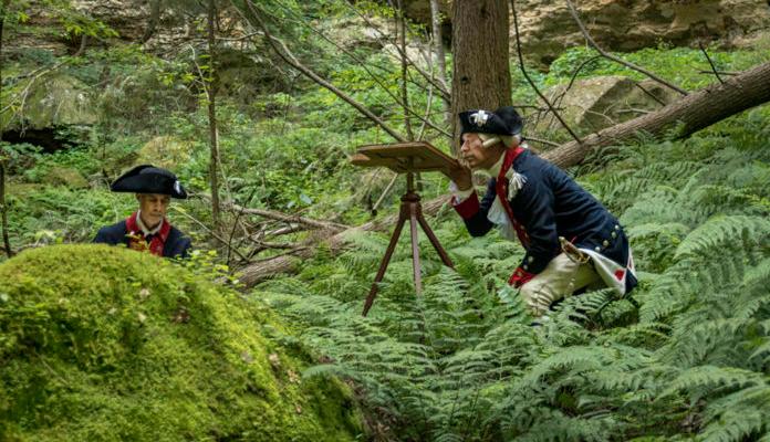
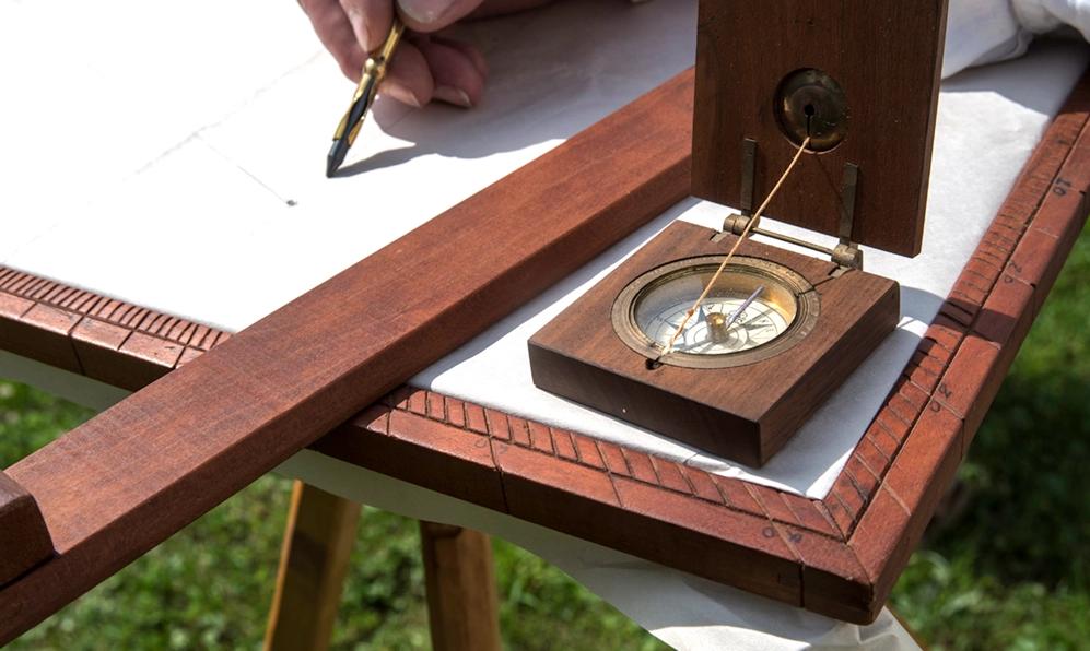
In a canyon in Hocking Hills, Ohio, a group of men wearing 18th century-style clothing used surveying instruments to map the wilderness around them. The methods of the reenacting surveyors were captured on camera in the heat of summer in 2019, but the scenes would have looked much the same more than 200 years ago.
The
January 2023 Page 8
Re-enactors surveying in the Ohio wilderness in the summer of 2019. Photo by Dan Patterson
Re-enacted photography by Dan Patterson and a narrative by Mercer University professor Dr. Clinton Terry combine to bring history to life in Surveying in Early America: The Point of Beginning, An Illustrated History
award-winning book, published by the University of Cincinnati Press in
February 2021, details the techniques that professional surveyors used to map and divide the land of early America in the late 1700s. While other books have focused on specific surveying projects, this one is dedicated to the art and science of surveying itself, said Dr. Terry, associate professor of history and liberal studies in Mercer’s College of Professional Advancement
Dr. Terry has always been interested in and taught about technologies, including a course he developed called “ Technology and Culture in American History. ” Surveying is something people take for granted, but every piece of property they visit has been surveyed and documented, he said.

The history behind that is interesting and important. Starting in the 1720s, the profession of surveying advanced rapidly and was fully developed by the early 1800s. However, there was little change in surveying technologies until the 1970s, when laser, radio and GPS were introduced.
“ I found out that there was relatively little recent scholarship on the topic (of the development of surveying), ” Dr. Terry said. “ As Dan and I started looking at it, we started asking the question, 'Can we use present-day photography with historical subjects, as a primary source, as evidence for scholarship?’ We decided that we absolutely could. The photography is absolutely first-rate. The text is what would be an academic history of the profession in the colonies in the United States. ”
Dr. Terry used 18th century source materials as much as possible in his research, including surveying instruction manuals and the papers of George Washington. While America’s first president didn’t develop the surveying profession, he used the techniques often and documented his efforts. Therefore, the book prominently features Washington from his teenage years as a professional
The Florida Surveyor Page 9
Dr. Clinton Terry
surveyor, to his military career where he was always in need of better maps, to his 1777 request for Congress to establish the Department of the Geographer, a formal mapping unit for the Continental Army.
Today, the Department of the Geographer exists as a re-enactment group, where members follow the 18th century manual as they survey land. They use period-correct methods and equipment, dress in historically accurate clothing and uniforms, and survey in period-correct settings.
This re-enactment group actually sparked the initial idea for the book. Patterson and Dr. Terry have been friends since the 1980s, and they always talked about doing a historical project together. Around 2000, Patterson made contact with the Department of the Geographer, which sparked a project of mutual interest for the pair.
The re-enactors later agreed to be featured in the book, and Patterson photographed them surveying in both civilian clothing and military uniform in two forest locations in what’s known as the Seven Ranges of Townships in Ohio. One of the areas is in the process of being allowed to return to “ old growth forest ” and has not been touched for more than 50 years.
Re-enactors using surveying equipment. Photo by Dan Patterson

“
They are very serious about getting this right. This is more than a hobby to them. When they are out in the field, they are following the unit manual to the letter, ” Dr. Terry said. “ Each of the photographs was a snapshot of them doing exactly what they would do if they were surveying a map. None of this is staged. ”
Academic histories have largely consisted of words on paper in the past, but public history efforts in more recent decades have embraced other source materials. The re-enacted photography in Surveying in Early America provides new visuals to better contextualize this chapter of history.
“ There are all kinds of new and exciting ways of approaching our study and recollection of the past and its meaning to ourselves in the present and future, ” Dr. Terry said. “ There are a tremendous amount of possibilities here if photography can be used as a primary source. If re-enacting and recreation with attention to historical detail is valid, this was our attempt to do a project with regard to that. ”
Surveying in Early America has been well-received since its publication. The book
January 2023 Page 12
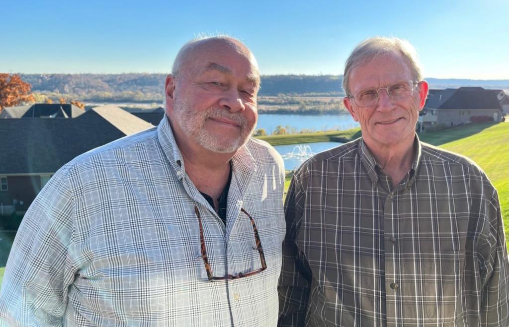
Dan Patterson and Dr. Clinton Terry. Photo courtesy Dr. Clinton Terry
won gold in the general history nonfiction category at the 2022 Midwest Book Awards this summer.
The authors have done a number of presentations on their research, including for a Smithsonian Associates online program in July 2021; the George Washington Symposium at Mount Vernon in November 2021; the Filson Club Historical Society in Louisville, Kentucky, in June; and the Nebenzahl Lectures on Surveying Performance at the Newbury Library in Chicago last month.
Re-enactors using surveying equipment.
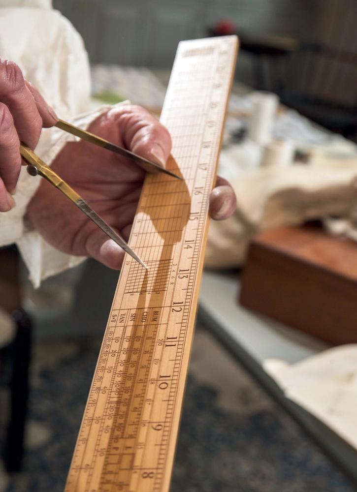
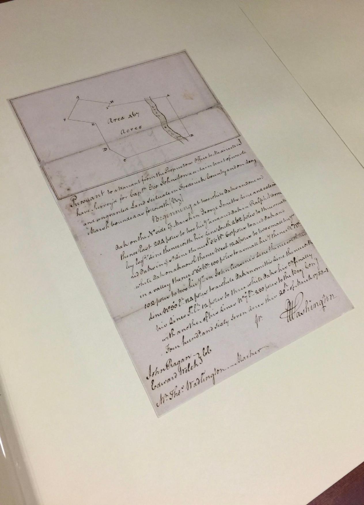
Photo by Dan Patterson A page of surveying notes by George Washington. Photo by Dan Patterson
The Florida Surveyor Page 13
I worked for Mr. Pittman as my first job after college. I was hired to be a drafter but he wanted me to be a secretary and book keeper. I’ll never forget him telling me at my first and only review that I was hands down the worst Secretary and book keeper he had ever had! I said that’s because I am a drafter! He was honestly brutal like that! I think everyone in the engineering/surveyor field in town worked for him at some point in some capacity. He is credited with training several of the local surveyors in the area and helping them launch their careers. They just don’t make them like him anymore. My sincere condolences to his family. Rest In Peace Mr. Pittman.
Oscar was the best of the best in the surveying profession. Whenever your path crossed his he always had a great story to tell. He's gone but he will never be forgotten. RIP Mr. Pittman!
I worked for Mr. Pittman for several summers and part time, while attending HS and PJC. He was the best surveyor! He helped start the surveyor degree program at UF assisting Professor Gibson, while I was there getting a Civil Engineering degree. The family can rejoice knowing he is with the Lord Jesus!!! He always expected and delivered the best survey possible!!!
I worked with Oscar several summers when he ran my father’s surveying crew. He really took good care of me when I was working pulling chains and cutting lines at age 14 to 17. I wish I could remember all the hilarious stories which were made even funnier by his laughter after telling it. Once he thought he might have killed me when I got overheated on a really hot summer day. I often stopped by his surveying business after coming back from college and med school just to hear more stories and to get survey work done on several projects. He never stopped calling me Billy and I loved it.
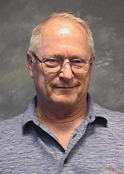
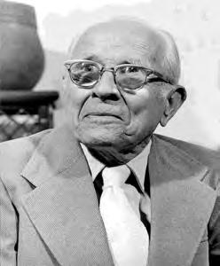
Oscar W. Pittman
November 2, 1935 – December 19, 2022


Oscar W. Pittman, 87, of Pensacola, died Monday, Dec. 19. He loved to tell stories and make people laugh. For more than 50 years he was a licensed land surveyor. He also served as an adjunct professor at Pensacola State College and the University of West Florida. Through teaching and running his business, Pittman & Associates, he became a mentor to a score of younger surveyors. He was an avid hunter and angler, often competing in field trials for bird hunting dogs. He was born on a farm outside Marianna. His father, Daniel, died when Oscar was only 8, and his mother, Gussie, had to turn to sharecropping to support him and his four sisters. In 1954 he went to work for the Escambia County surveyor and discovered he liked the profession, in part because it was outdoor work. He earned his own surveyor’s license in 1961 and became the Escambia County surveyor himself in 1971. He opened his own business in 1975 and ran it until he retired in 2000. He served in the Florida National Guard for nine years. He was a former deacon of Pine Haven Baptist Church, a current member of Plainview Baptist Church and a former board member of the Lion’s Club and a 32nd Degree Mason. He is survived by his wife of 67 years, Lou (Grubbs); his son Craig Pittman of St. Petersburg;; and two grandchildren.

FSMS Pioneers
AseriesthathonorsthelegendsofsurveyinginthestateofFlorida
Oscar Pittman
 By Dominic Levings
Afteracareerthatbegansixdecadesago,PittmanhascementedhislegacyinFlorida
The Early Years
The world was a lot different in 1961 than it was today. Fiftyseven years ago, the Compact Cassette tape had not yet been invented. John F. Kennedy was the President of the United States. Only 5 million people lived in Florida, and nobody had any clue what “Star Wars” was. One thing, however, is not different: and that is Florida License Survey Number 1748, which belongs to Oscar Pittman of Pensacola, Florida.
To say that Pittman had a distinguished career would be an understatement. His career in the profession spanned a remarkable 55 years. Over that period, he founded his own company, taught classes for 15 years, and served on the Florida Board of Professional Surveyors and Mappers, to name but a few of his accomplishments.
But what is surely most indicative of his success is the legacy he has left behind. His name has become synonymous with surveying great-

ness in Pensacola, and his surveying tree has so many branches, it is perhaps unrivaled anywhere else in Florida.
Pittman, 82, was born on November 2nd, 1935 in Marianna, Florida, the second youngest of six children, and the only boy. He grew up on an 80-acre farm with his sisters and his parents, Gussy and Daniel.
“You never run out of work on a farm,” Pittman said of his early years in Marianna. “You never catch up. That’s just not gonna happen. Especially when you have hogs, cows, and chickens, and have to raise crops, too. It’s a steady thing.”
After graduating high school in 1953 at the age of 17, Pittman moved to Pensacola seeking employment. He moved in with one of his sisters and her family while he searched for a job. He worked a few odd jobs here and there, including a stint at a local grocery
store, before he landed a job installing a sprinkler system at the nearby Naval Air Station.
It was the requirements of this job that eventually led Pittman into the surveying profession. He was able to decipher the complicated layout plans for the piping network of the sprinkler system. He was retained by the company and aided in interpreting layouts, charts, and instructions.

Soon after, he went to work for the county surveyor, and started as a crewman in the field. In 1961, he became a licensed surveyor after passing the official exam. He also obtained licenses in Alabama, Mississippi, and Georgia.
Pittman says his love for property, nature, and the outdoors is the primary reason he fell in love with surveying, a result of his youth spent on the family farm. He also cites the lack of monotony involved with the profession.
Page 15
The Florida Surveyor 15 February 2018
“I’ve always been enamored by property. I just enjoy property and always have. I like to be out on the ground – you do something different every day. No two jobs in surveying are alike. Not to me, at least,” Pittman explained.
Running section lines has always been his favorite type of survey. While he admits it is not the most profitable work, he relishes the challenge in trying to prove corners and find original monument markers.
“It’s like being a detective, really,” Pittman said.
Pittman recalled one survey in which he found three out of four witness trees from a survey originally conducted in the 1800s. He was also able to locate the original corner post, marked by a stone monument, which was a ballast stone from a 19th-century ship.
Pittman & Associates
In 1975, Pittman founded Pittman & Associates in Pensacola. He ran the company for 25 years, forging it into the premiere surveying firm of the Panhandle area. In 2000, he sold the firm to longtime employee David Glaze, who still owns Pittman, Glaze & Associates today.
Glaze remembers the first time he met Pittman, during an interview for a job. In the interview, Pittman
asked Glaze how to calculate some coordinates by hand, but he didn’t know how. Then, right in the interview, Pittman took the time to teach him how to do it.
“How many people will do something like that? ” Glaze said. “Even in the first job interview, I learned something from him.”
What Glaze admires most about his former boss, however, is his leadership style and personality.
“He was many things. He was a great teacher. He was a hard taskmaster. He expected you to do your job and do it well and not screw around,” Glaze said.
“But he was a very ethical man. Oscar was probably the most ethical man I’ve ever met in my life. And I learned a tremendous amount from just staying after work and discussing surveying with him.”
Another likeable aspect of Pittman, Glaze added, is that he is
an “extreme joke teller”. He recalled that one year at an FSMS conference, Pittman was under a gazebo outside the hotel, rattling off one joke after another to a small crowd. During the impromptu performance, one attendee, who didn’t know Pittman, said that he was glad that FSMS had hired someone to entertain at the conference.
Ronald Ruben worked for Pittman from 1986 through 1989. He interviewed for a job with Pittman when he was only 19 (while humorously wearing a three -piece suit). Today, Ruben owns Ruben Surveying & Mapping in Gulf Breeze, Florida, which he started in 1998.
“I love Oscar. He’s the reason why I am where I am today and I make the money that I make. I truly attribute it to him having selected me for the profession. I had no idea at 19 that it’d be the only job I’d ever have,” Ruben said.
Ruben worked with Glaze and Glaze’s younger brother, Jay, during the “golden years” of Pittman & Associates. They all worked on the same crew – David was the crew chief, and Jay and Ruben were the rodman and instrument man.
Like Glaze, Ruben admired Pittman’s style as a boss and attributes his own success as a business owner to the lessons he learned from him.
“He had the patience of Jobe. He was calm, he was kind. He was not
January 2023 Page 16
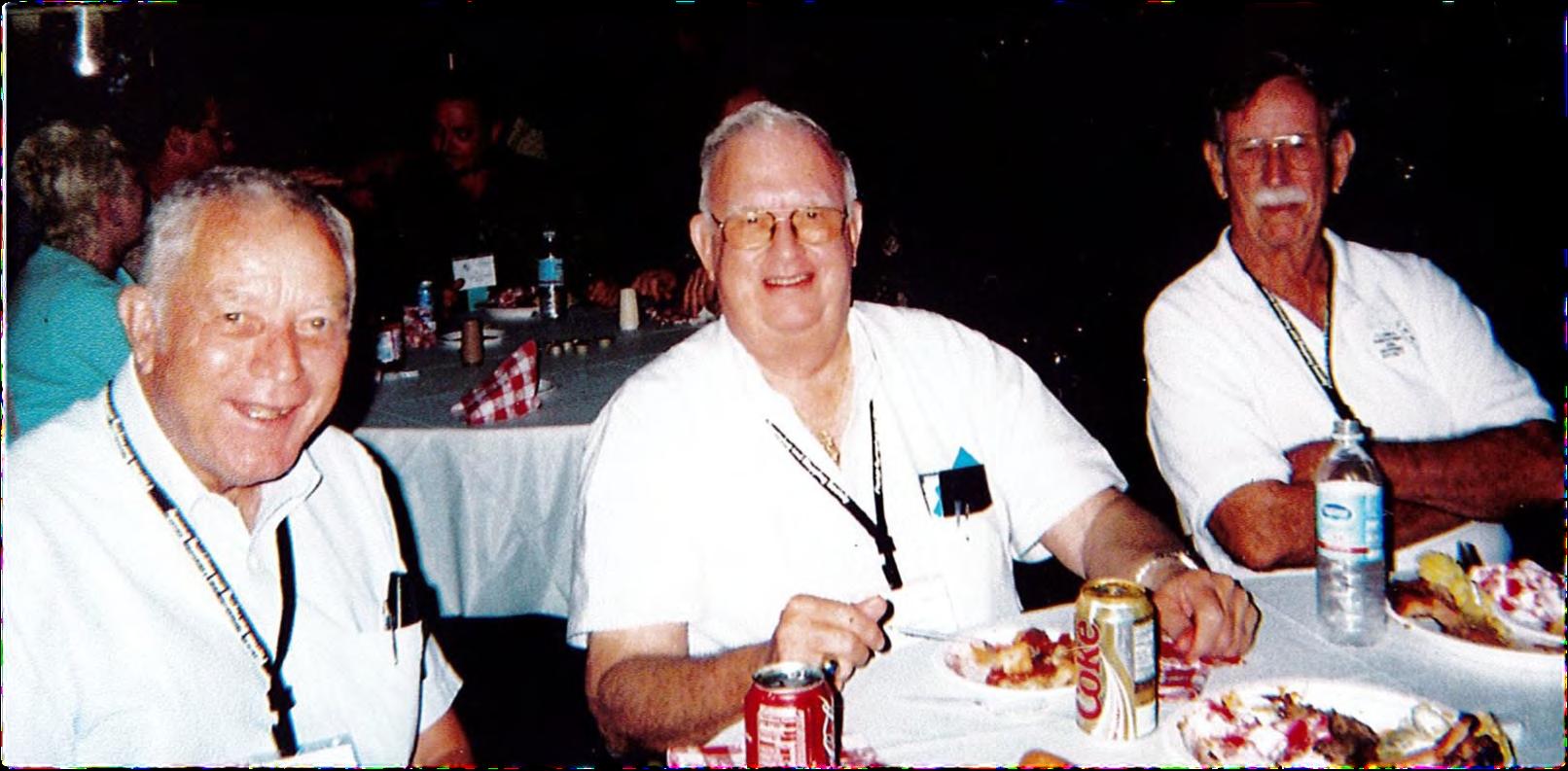
Oscar Pittman, Harley Gilmore, and Fred Duell at the 50th annual FSMS Conference in 2005.
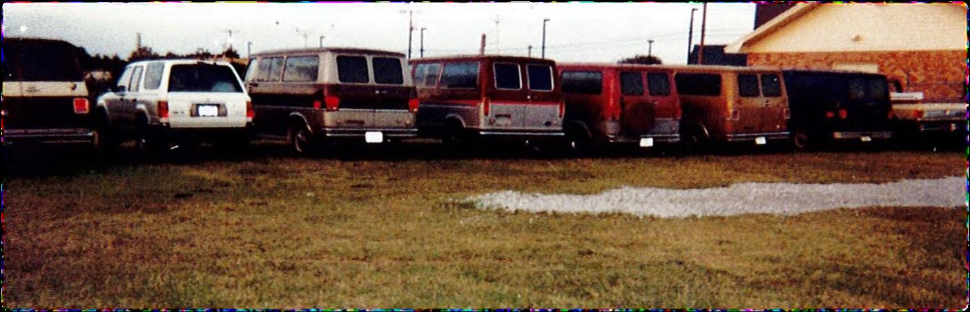
Surveying vans lined up in the lot behind Pittman & Associates, circa 1999.
an [expletive]. You know what I mean?” Ruben explained.
“He was all the things that I aspired to be [as a boss]. His personality allowed him to be a great boss. He was fair, he understood. His checks were always on time. He’s a good church-going, god-fearing, family man.”
On Changes in the Profession and Teaching
Consistent involvement in surveying over a 57-year period has allowed Pittman to observe and analyze changes in the profession. He laments how technology has replaced some of the meat-and-bones fundamentals of surveying, which were a staple in his heyday.

In his first job surveying with the county, the crew utilized transits and levels, which are antiquated today, and an individual had to start out at the bottom of the totem pole on the field crew. You would then move your way up on the crew as you gained experience.
“What’s got me concerned is that most firms now are running twoman crews. When I first started, you began as a tail chainman, then head chainman, then instrument man, then party chief. Now, when you’re hired, there’s no learning process. There’s no ladder,” Pittman said.
“A lot of guys now are data collectors, and they turn angles and distances and bring it to the office and someone with AutoCAD will plot it out and make the decision. People aren’t getting the experience to be licensed surveyors. How do you find people, how do you train people? How do you get people interested in surveying anymore? ”
While he acknowledges that the increased use of technology in the profession is inevitable, Pittman believes that individuals should still be taught the what and why of the technology in order to fully grasp the role of a surveyor.
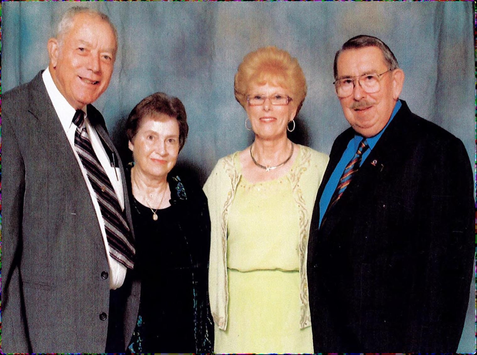
Oscar and his wife Lou (left) with Buddy and Sharon Bannerman at the Renaissance Hotel in Orlando in 2006. Bannerman was the FSMS President in 1983 -1984.
After selling Pittman & Associates in 2000, Pittman was not quite done contributing to the profession. After a professor at Pensacola State College left in the middle of the semester, the administration contacted him and asked if he would finish teaching the “Construction Surveying” course as an adjunct professor. The rest is history, as Pittman taught for another 15 years; for two of those years, he also taught a class at the University of West Florida.
Like many teachers who truly enjoy their job, Pittman’s interaction with his students was what he valued most.
“If you’ve got students who want to learn, it makes all the difference in the world. You just enjoy teaching somebody who wants to learn. If you’ve got someone who could care less, it takes all the fun out of it,” Pittman said.
“It was just something I enjoyed doing. I enjoyed meeting the people. And it was interesting to see how some of the students think.”
Family
Pittman and his wife, Lou, have been married for 62 years.
“Best wife I ever had,” Pittman joked. “I’m surprised she hasn’t killed me. She hasn’t even attempted so far – that I know of.”
The events of their wedding day sound like something suited for a dark comedy. On the way to the wedding, Pittman got into a car wreck. The driver who slammed into him was drunk and was taken to jail, and Pittman’s car had to be towed. He had to hitch a ride to the wedding.
The Florida Surveyor Page 17
The Florida Surveyor 17 February 2018
The gaze of a seasoned surveyor.
But the misfortune didn’t stop there. Their preacher, who was to marry them, had had a heart attack earlier in the day and was in the hospital. Fortunately, another preacher of the church was a guest of their wedding and agreed to preside over the ceremony.
Some of Pittman’s friends didn’t think the marriage would last. They said that “Oscar was too wild” – something he doesn’t disagree with. In fact, Pittman will be the first to tell you that he used to “run the streets”.
“When you’re young, you’re running the streets. Only two things are important to you, a car and your clothes. You won’t have anything else cause you’re broke all the time. Dating and the car were expensive. You weren’t making much money,” Pittman said.
But of course, after 62 years of marriage, Pittman has proved his doubters wrong. He and Lou have one son, Craig Pittman, and two grandsons. Craig has been an environmental reporter for the Tampa Bay Times since 1998. He has also authored four books, all of which are nonfiction and revolve around events in Florida. His most recent book, Oh, Florida!¸was published in 2016 and named a New York Times bestseller.
Retirement and Reflection
After retiring from teaching in 2015, Pittman found himself with no work-related obligations for the first time in over 60 years.
“Once I retired, I found out I got six Saturdays and one Sunday every week. I highly recommend it,” he joked.
He is still a member of FSMS and has attended a phenomenal 57 straight FSMS conferences. He attended his first conference in 1961 – the year he became a licensed surveyor – and hasn’t

missed one since.
“You meet a lot of people at the conference. You learn. Your local competitors won’t help you out, because you’re competitors. But if you’re out of town at the conference, everyone figures hey, they’re not my competition, so I don’t care. You share a lot of things, how you do indexing, how you bill, what have you learned about this, etc.,” he said.
the name recognition and the reputation he had,” Glaze said. “I tried for two years to get on with him because he was the best and he had that reputation. I actually took a pay cut to go and work for him.”
“He’s trained a lot of the surveyors here locally. I’d say half the surveyors here locally have worked for him. The quality of surveyors around town…the ones that were trained by Oscar, have the best reputation.”
Ruben also cited Pittman’s reputation as evidence of his success. His prestige is so great, that employees of Ruben Surveying & Mapping have a nickname for Pittman’s corner monuments.
“He’s respected in the Panhandle and throughout the state. When we come across a Pittman 1748 at Ruben Surveying, we call it a ‘godrod’. That sucker is gold, baby,” Ruben exclaimed.
When asked what he remembers most fondly about his time in the profession, Pittman wasted no time in answering.
“You know, I just enjoyed doing what I did. I enjoyed the people. I had clients that were with me for quite a number of years. That always made me feel good, that you had people that were always your client and didn’t go to anyone else,” Pittman said.
It appears that his clients had good reason to stick with him. Glaze says that Pittman’s reputation was the sole reason he didn’t start his own company, and that his stature as a leader and teacher resonate throughout Pensacola.
“That was a no-brainer. That was the whole reason for buying his company instead of starting my own, was
Recently, Pittman began taking a class at a local Methodist church. The class is about writing your life story – whether it be for your kids, your grandkids, and quite possibly, someone you’ll never know.
The class has given Pittman reason to reflect back on his own life, and has also invoked in him a tinge of regret.
“There’s a lot of questions now I wish I would’ve asked my mom before she passed. I would like to know how her and my dad got together, what their life was like when they were young, how they met, that sort of thing,” he said.
Although Pittman may have questions about the lives of his parents that will never be answered, there is little question that future readers of his yet-finished life story will be reading the words of a surveyor who belongs among the ranks of Florida’s greatest.
January 2023 Page 18
The Florida Surveyor 18 February 2018
Oscar now has a lot more time for fishing.

The Florida Surveyor Page 19 • Civil/Site Design • Construction Engineering • Construction Materials Engineering & Testing • Energy • Environmental, Health, and Safety • Geotechnical • MEP • Structural • Survey & Geospatial • Transportation • Urban Planning & Design • Water Resources • Water/Wastewater PARTNERS FOR WHAT’S POSSIBLE www.pennoni.com Join our Survey Team in Florida today! The End of the Biennium is on February 28, 2023! • This is the deadline for License Renewal. • Licensed Surveyors are Required to have Completed at least 24 Continuing Education Credit Hours. Need Continuing Education Credits? (Click Here) FSMS Full/Government Members get a Voucher towards any 3 Hour Course of Your Choice. To Claim Your Voucher, Contact our Education Director Samantha Hobbs at education@fsms.org .
January 2023 Page 20
6 General CEC - $99/course (members) $120/course (non-members)
3 General CEC - $49/course (members) $70/course (non-members)
2023 eLearning Courses
• History of Surveying - Course #7140 • Identification of Native & Non-Native Trees in Florida - Course #8132 • Ethics for the Design Professional - Course #8621 • Land Tenure & Cadastral Systems - Course #8260 • Map Projections & Plane Coordinate Systems - Course #8261 • Public Land Survey System - Course #7147 • Remote Sensing Applications to Surveying & Mapping - Course #7148 • Practical Geometry for Surveyors - Course #7141
• Basics of Real Property - Course #8360 • Elevation Certificates & the Community Rating System - Course #8256 • Introduction to Photogrammetry - Course #7968 • Writing Boundary Descriptions - Course #8362
Florida Surveying & Mapping Society 1689 Mahan Center Blvd. Suite A Tallahassee, FL 32308 www.fsms.org (850) 942-1900
Florida Surveying and Mapping Continuing Education Provider Offering 25 Years of Dedication, Quality & Trusted Services
Step 1: Choose Course(s)
3 Hour Courses Available
A History of the Prime Meridian Marker,
Basics of Real Property
Digital Signatures for Surveyors
Easements and Rights of Ways,
Elevation Cert *2020 UPDATED COURSE
Introduction to Photogrammet
Quality Assurance/Quality Cont , #9293, 3 CEC
Boundaries in Florida
Chapter 177, Platting (Plat Law)
Critical Communication for Surveying & Mapping Professionals
Ethics for the Design Professional
Florida Laws
Florida Surveying Law and Rule Changes
Geographic Information Systems (GIS)
History of Surveying,
Identification of Native and Non-Native Trees in Florida
Land Tenure and Cadastral Systems
Map Projections and Plane Coordinate Systems , #7669, 6 CEC
Practical Geometry for Surveyors, #7109, 6 CEC
Public Land Survey System, #6979, 6 CEC
Remote Sensing Applications to Surveying & Mapping, #6972, 6 CEC
*2020 UPDATED COURSE
The Florida Surveyor Page 21
□
□
□
□
□
□
□
□
□
□
□
□
□
□
□
□
□
□
□
□
□
□
Writing Boundary Descriptions 6 Hour Courses
January 2023 Page 22 Step 2: Choose Member Type FSMS Member EMAILED Fee Quantity Amount 6 CEC $115 Per Course x = $ 3 CEC $58 Per Course x = $ MAILED 6 CEC $125 Per Course x = $ 3 CEC $68 Per Course x = $ TOTAL $ Non Non Name: _ YES _ NO Firm: ____ _ YES _ _ NO Address: ______________________________________________________________________________________ City/State: Email Address: Work Phone: Payment Information: ___ Check Enclosed (Payable to FSMS) _ VISA/MasterCard/American Express Card #: _______ Exp. Date: __ CVV Code:___________ Billing Address of Credit Card: ______________________________________ Signature: _____________________________________ __ IF PAYING BY CHECK, MAIL FORM TO: FSMS, P.O. Box 850001-243, Orlando, Florida 32885-0243 IF PAYING BY CREDIT CARD, FAX OR EMAIL FORM TO: 850.877.4852 education@fsms.org QUESTIONS? CALL 800.237.4384 Provider No. CE11 fsms.org

3002 Surveying 833-352-3002 A Accuright Surveys of Orlando, Inc. 407-894-6314 Agnoli, Barber & Brundage, Inc. 239-597-3111 AIM Engineering & Surveying 239-332-4569 Airworks 857-990-1060 Allen & Company, Inc. 407-654-5355 Allen Engineering 321-783-7443 American Consulting Professionals, LLC. 813-435-2600 American Surveying, Inc. 813-234-0103 Amerritt, Inc. 813-221-5200 Arc Surveying & Mapping, Inc. 904-384-8377 Ardurra, Inc. 239-292-7773 Associated Land Surveying & Mapping, Inc. 407-869-5002 Atlanic Drafting & Surveying 386-264-8490 Avirom & Associates, Inc. 561-392-2594 Axis Geospatial SE, LLC. 410-822-1441 B Banks Engineering 239-939-5490 Barnes, Ferland and Associates, Inc. 407-896-8608 Barraco & Associates, Inc. 239-461-3170 Bartram Trail Surveying, Inc. 904-284-2224 Bello & Bello Land Surveying Corporation 305-251-9606 Benchmark Surveying & Land Planning, Inc. 850-994-4882 Berntsen International 608-443-2772 Betsy Lindsay, Inc. 772-286-5753 Biscayne Engineering Company, Inc. 305-324-7671 Boatwright and Durden Land Surveyors, Inc. 904-241-8550 Bock & Clark Corporation(NV5) 330-665-4821 Bowman Consulting Group 703-454-1000 Bradshaw-Niles & Associates, Inc. 904-829-2591 Brown & Phillips, Inc. 561-615-3988 BSE Consultants, Inc. 321-725-3674 Buchanan & Harper, Inc. 850-763-7427 C Calvin, Giordano, & Associates 954-921-7781 Carlson Environmental Consultants, PC 561-371-2402 Carter Associates, Inc. 772-562-4191 202 3 S u S taining

F irm S Directory Caulfield & Wheeler 561-392-1991 Chastain-Skillman, Inc. 863-646-1402 CHW Professional Consultants (Causseaux, Hewett & Walpole, Inc.) 352-331-1976 CivilSurv Design Group, Inc. 863-646-4771 Clary & Associates, Inc. 904-260-2703 Clements Surveying, Inc. 941-729-6690 Clymer Farner Barley, Inc. 352-748-3126 Coastal Engineering Associates, Inc. 352-796-9423 Colliers Engineering & Design 732-383-1950 Collins Survey Consulting, LLC. 863-937-9052 Compass Engineering & Surveying, Inc. 727-822-4151 Cousins Surveyors & Associates, Inc. 954-689-7766 CPH Consulting, LLC 407-322-6841 Craven-Thompson & Associates, Inc. 954-739-6400 Cross Surveying, LLC 941-748-8340 Culpepper & Terpening, Inc. 772-464-3537 Cumbey & Fair, Inc. 727-324-1070 D DeGrove Surveyors, Inc. 904-722-0400 Dennis J. Leavy & Associates 561-753-0650 Dewberry 321-354-9729 DMK Associates, Inc. 941-475-6596 Donald W. McIntosh Associates, Inc. 407-644-4068 Donoghue Construction Layout, LLC. 321-248-7979 Douglass, Leavy & Associates, Inc. 954-344-7994 DRMP, Inc. 407-896-0594 DroneView Technologies 248-321-9417 DSW Surveying & Mapping, PLC. 352-735-3796 Duncan-Parnell, Inc. 407-601-5816 Durden Surveying & Mapping, Inc. 904-853-6822 E Echezabal & Associates, Inc. 813-933-2505 ECHO UES, Inc. 888-778-3246 Eda Consultants, Inc. 352-373-3541 E.F. Gaines Surveying Services, Inc. 239-418-0126 Eiland & Associates, Inc. 904-272-1000 Element Engineering Group, LLC. 813-386-2101
Engenuity Group, Inc. 561-655-1151 Engineering Design & Construction, Inc. 772-462-2455 ER Brownell & Associates, Inc. 305-860-3866 ESP Associates FL, Inc. 813-295-9024 ETM Suryeying & Mapping 904-642-8550 Exacta Land Surveyors, Inc. 866-735-1916 EXP Energy Services Inc. 305-213-9969 F Ferguson Land Surveyors 727-230-9606 First Choice Surveying, Inc. 407-951-3425 Florida Design Consultants, Inc. 727-849-7588 Florida Engineering & Surveying, LLC. 941-485-3100 FLT Geosystems 954-763-5300 Ford, Armenteros & Fernandez, Inc. 305-477-6472 Fortin, Leavey, Skiles, Inc. 305-653-4493 F.R. Aleman & Associates, Inc. 305-591-8777 Frontier Precision Unmanned 701-222-2030 F.R.S. & Associates, Inc. 561-478-7178 FTE Engineers & Planners 800-639-4851 G Gary Allen Land Surveying 850-877-0541 GCY, Inc. 772-286-8083 GeoData Consultants, Inc 407-732-6965 Geoline Surveying 386-418-0500 Geomatics Corporation 904-824-3086 Geo Networking, Inc. 407-549-5075 GeoPoint Surveying, Inc. 813-248-8888 George F. Young 727-822-4317 GeoSurv, LLC. 877-407-3734 Germaine Surveying, Inc. 863-385-6856 GPI Geospatial, Inc. 407-851-7880 Gustin, Cothern & Tucker, Inc. 850-678-5141 H Haley Ward, Inc. 239-481-1331 Hanson Professional Services, Inc. 217-788-2450 Hanson, Walter & Associates, Inc. 407-847-9433 H.L. Bennett & Associates, Inc. 863-675-8882 202 3 S u S taining
Hole Montes, Inc. 239-254-2000 HUB International 850-386-1111 Hyatt Survey Services 941-748-4693 I I.F. Rooks & Associates, LLC. 813-752-2113 J John Ibarra & Associates, Inc. 305-262-0400 Johnson, Mirmiran & Thompson, Inc. 813-314-0314 Johnston’s Surveying, Inc. 407-847-2179 K KCI Technologies 954-776-1616 Keith and Associates, Inc. 954-788-3400 Kendrick Land Surveying 863-533-4874 L L&S Diversified, LLC. 407-681-3836 Land Precision Corporation 727-796-2737 Landmark Engineering & Surveying Corporation 813-621-7841 Langan Engineering 973-560-4900 Leading Edge Land Services, Inc. 407-351-6730 Leiter Perez & Associates, Inc. 305-652-5133 Lengemann Corp. 800-342-9238 Leo Mills & Associates 941-722-2460 LiDARit Inc. 407-946-1398 LiDAR USA 256-274-1616 Long Surveying, Inc. 407-330-9717 M Manuel G. Vera & Associates, Inc. 305-221-6210 Marco Surveying & Mapping, LLC. 239-389-0026 Massey-Richards Surveying & Mapping, LLC. 305-853-0066 Masteller, Moler & Taylor, Inc. 772-564-8050 McCain Mills, Inc. 813-752-6478 McKim & Creed, Inc. 919-233-8091 McLaughlin Engineering, Co. 954-763-7611 Metron Surveying and Mapping, LLC. 239-275-8575 Metzger + Willard, Inc. 813-977-6005 Midwest Aerial Photography 614-853-2902 Mills & Associates, Inc. 813-876-5869 Mock Roos & Associates, Inc. 561-683-3113 F irm S Directory
Moore Bass Consulting, Inc. 850-222-5678 Morris-Depew Associates, Inc. 239-337-3993 Murphy’s Land Surveying 727-347-8740 N Navigation Electronics, Inc. 337-237-1413 Northwest Surveying, Inc. 813-889-9236 NV5, Inc 407-896-3317 O On The Mark Surveying, LLC. 321-626-6376 Orange orangeuas.com P PEC Surveying & Mapping 407-542-4967 Pennoni Associates, Inc. 863-594-2007 Perret and Associates, Inc 904-805-0030 Pickett & Associates, Inc. 863-533-9095 Platinum Surveying & Mapping, LLC. 863-904-4699 Point Break Surveying 941-378-4797 Polaris Associates, Inc. 727-461-6113 Porter Geographical Positioning & Surveying, Inc. 863-853-1496 Pro-Line Survey Supply, Inc. 904-620-0500 Pulice Land Surveyors, Inc. 954-572-1777 Q Q Grady Minor & Associates, PA 239-947-1144 R Reece & White Land Surveying, Inc. 305-872-1348 Rhodes & Rhodes Land Surveying, Inc. 239-405-8166 Richard P. Clarson & Associates, Inc. 904-396-2623 R.J. Rhodes Engineering, Inc. 941-924-1600 R.M. Barrineau & Associates, Inc. 352-622-3133 Robayna and Associates, Inc. 305-823-9316 S SAM Surveying & Mapping, LLC. 850-385-1179 SCR & Associates NWFL Inc. 850-527-1910 Sergio Redondo & Associates, Inc. 305-378-4443 Settimio Consulting Services 850-341-0507 SGC Engineering, LLC. 407-637-2588 Shah Drotos & Associates, PA 954-943-9433 202 3 S u S taining

Shannon Surveying, Inc. 407-774-8372 Sherco, Inc. 863-453-4113 Sliger & Associates 386-761-5385 Southeastern Surveying & Mapping Corp. 407-292-8580 Stephen H. Gibbs Land Surveyors, Inc. 954-923-7666 Stoner Inc. 954-585-0997 SurvTech Solutions, Inc. 813-621-4929 T T2 UES Inc. 407-587-0603 Tectonic Engineering and Surveying Consultants 800-829-6531 Thurman Roddenberry & Associates 850-962-2538 U Upham, Inc. 386-672-9515 W Wade Surveying, Inc. 352-753-6511 Wallace Surveying Corp. 561-640-4551 Wantman Group, Inc. 561-687-2220 WBQ Design & Engineering, Inc. 407-839-4300 Winningham & Fradley, Inc. 954-771-7440 Woolpert, Inc. 803-214-5928 Z ZNS Engineering, LLC. 941-748-8080 F irm S Directory SOCIAL MEDIA LINKS LinkedIn = 280 Followers Facebook = 751 Followers Twitter = 403 Followers Instagram = 153 Followers YouTube
PUTTING THE BEST “FOOT” FORWARD: ENDING THE ERA OF THE U.S. SURVEY FOOT
(1959 TO 2022)
Since 1893, the legal definition of the foot in the United States has been based on the meter. The definition adopted at that time was the one specified by Congress in 1866, as 1 foot = 1200/3937 meter exactly (or 1 foot = 0.304 800 6 meter approximately).
In 1959, the relationship of the foot to the meter was officially refined as 1 foot = 0.304 8 meter exactly. This change was made to support United States industry and international trade. It resolved a long-standing discrepancy with the definition used by different organizations within the United States and in other countries.
The 1959 redefinition of the foot was legally binding and intended for the entire United States. But a single exception temporarily allowed continued use of the previous definition of the foot, exclusively for geodetic surveying. To distinguish between these two versions of the foot, the new one was named the “international foot” and the old one the “U.S. survey foot.” It was furthermore mandated that the U.S. survey foot be replaced by the international foot upon readjustment of the geodetic control networks of the United States. Although such a readjustment was completed in 1986, use of the U.S. survey foot persisted. This situation has led to confusion and errors that continue to this day, and it is at odds with the intent of uniform standards.
To resolve problems due to simultaneous use of two nearly identical versions of the foot, collaborative action is being taken by the National Institute of Standards and Technology (NIST) and the National Geodetic Survey (NGS), National Ocean Service (NOS), National Oceanic and Atmospheric Administration (NOAA). With the goal of providing national uniformity in the measurement of length, the U.S. survey foot will be phased out as part of the modernization of the National Spatial Reference System (NSRS). From this point forward, the international foot will be simply called the foot. A Federal Register Notice (FRN) has been issued to solicit public comment to ensure that this change is made in an orderly fashion with minimal disruption.
https://www.nist.gov/pml/us-surveyfoot
The Florida Surveyor Page 29
2022 NCEES SURVEYING EDUCATION AWARD CEREMONY HELD AT FAU
Florida Atlantic University Geomatics Program was recognized this year with a $15,000 surveying education award from NCEES . FAU Geomatics Engineering is one of the seven university programs in the nation that received the NCEES Surveying Education Award in 2022 .
According to NCEES, “The NCEES Surveying Education Award recognizes surveying/ geomatics programs that have a broad and robust curriculum and best reflect NCEES’ mission to advance licensure for surveyors in order to safeguard the health, safety, and welfare of the public. The award is intended to encourage programs to engage their students with other professionals, introduce them to both historical and new technology, and promote licensure .”
An award ceremony was held in FAU Boca Raton Campus on November 16, 2022 to celebrate this achievement. Landon “Alfie” Cross, PSM, a current board member of the Florida Board of Professional Surveyors and Mappers (BPSM) was invited to visit FAU to present the award on behalf of NCEES. The Department Chair Dr. Kaisar
January 2023 Page 30
received the award on behalf of FAU Geomatics Engineering Program.
The industry supporters of FAU Geomatics Engineering program, Bryan Merritt, PSM, Senior Survey Project Manager, LANGAN, and Clyde R Mason II, PSM, Director of Survey Operations, Ritzel-Mason were also present at the meeting.
Dr. Bloetscher, Assoc. Dean for Undergraduate Studies and Community Outreach in the college gave a closing remark. Dr. Nagarajan and Dr. Su (faculty in FAU Geomatics Engineering), Brett Costanza and Leah Ballou (Officers of FSMS FAU Student Chapter) , and a group of current FAU Geomatics Engineering students also attended the ceremony. The ceremony was hosted by FAU Department of Civil, Environmental and Geomatics Engineering , and FSMS FAU Student Chapter.
The Florida Surveyor Page 31
FAU CEGE received 5 new GS18 and CS20 Leica GNSS units from FLT Geosystems as a part of their no-cost leasing program. We are thankful to this generous offer which will expose our students to the most recent technology out there.
CEGE RECEIVED
FAU
5 NEW GS18 AND CS20 LEICA GNSS UNITS FROM FLT GEOSYSTEMS AS A PART OF THEIR NO-COST LEASING PROGRAM
UF Geomatics
Fort Lauderdale Research & Education Center (FLREC)
3205 College Avenue Fort Lauderdale, FL 33314 geomatics-flrec@ifas.ufl.edu
UF Geomatics @ Fort Lauderdale Newsletter December 2022
The Geomatics program participated in numerous events that were virtual (e.g., Math Awareness Week 2022). We also attended and presented at inperson events when opportunities arose, including the South Florida GIS Expo, the 67th Annual FSMS conference, and the 2022 Esri User Conference.
Important 2023 Dates
• Jan. 9: Spring classes begin
• Feb. 15: Undergrad admission app deadline (Sum. C)
• May. 1: Undergrad admission app deadline (Fall)
• May 5-7: Spring commencement
• May 15: Sum A/C classes begin
• Aug 23: Fall classes begin
Selected Journal Publications
• Kaddoura, Y. O. et al: Georeferencing oblique PhenoCam imagery
• Mandourah, A. and Hochmair , H. H.: Analysing the Violation of Drone Regulations in three VGI Drone Platforms across the US, UK, and France. Geo-spatial Information Science
• Schirck-Matthews, A., H. H. Hochmair, et al.: Comparison of Cycling Path Characteristics in South Florida and North Holland among Three GPS Fitness Tracker Apps
• Cao, J., H. H. Hochmair, and F. Basheeh : The effect of Twitter app policy changes on the sharing of spatial information through Twitter users
Recent Awards
The Geomatics program at the Fort Lauderdale Research & Education Center (FLREC), with support from other academic programs at the FLREC, received an award from the UF/IFAS Equipment and Infrastructure Program for the purchase of a terrestrial 3D Laser Scanning System

Congratulations are in store for all of our newest graduates, Marco Krieger (BSc), Dr. Youssef Kaddoura and Dr. Ammar Mandourah (PhD)! Also, congratulations to Dr. Hochmair who was promoted to Full Professor!
We look forward to connecting with you again in 2023! Happy Holidays!
Registration for Spring 2023 courses is now available. Contact us today for an advising appointment!
• PhD candidate Innocensia Owuor received a CALS International Student Outstanding Achievement Award and the UF Alec Courtelis Award
• Youssef Kaddoura received the 2022 ASPRS’s Presidential Citation Award and the 2022 Chapter Coordinator Award from the FSMS Broward County Chapter.
This newsletter couldn’t possibly cover it all, so we encourage everyone to visit: https://flrec.ifas.ufl.edu/geomatics/
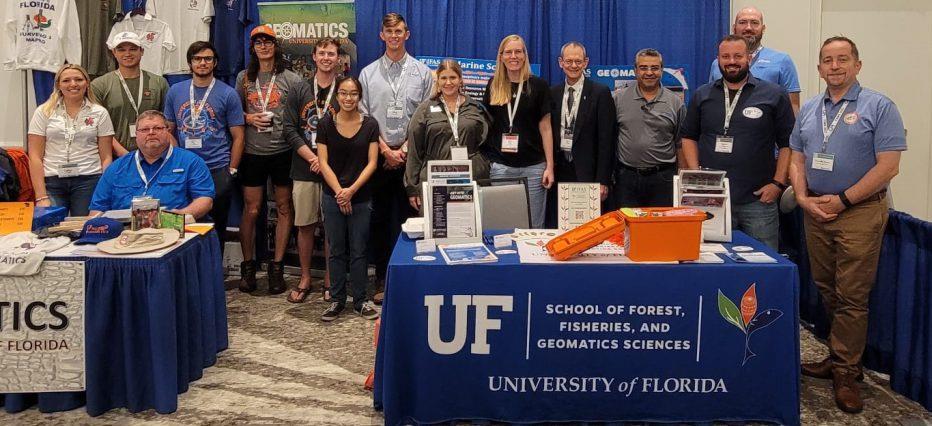
UF Geomatics at the 67th Annual FSMS Conference in Palm Beach Gardens in July 2022
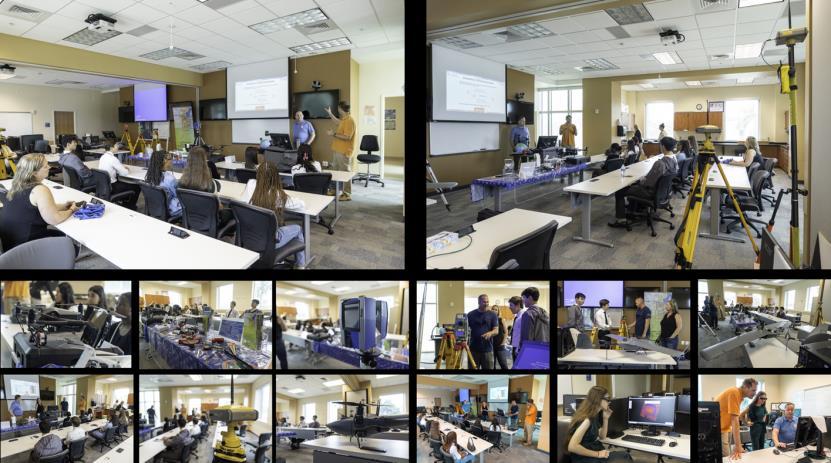
UF Geomatics hosted a workshop for a group of dual-enrollment senior students from South Broward High School in November 2022
Dual-enrollment students from South Broward High visiting UF Geomatics facilities
UF Geomatics @ Fort Lauderdale Newsletter December 2022
Get-STEM NSF Scholarships
We are pleased to announce that UF’s Geomatics program has awarded the first GeT-STEM project scholars for the 2022/2023 academic year.

A Message to Prospective Undergrad Students
The FLREC offers a 4-year, ABET accredited degree, the Bachelor of Science in Geomatics, which fully prepares graduates for professional licensure in the state of Florida and beyond. We are located 1 mile off Interstate 595 in the NW corner of the South Florida Education Center (Directions).
Our program is designed for both full-time and working students. Students registered at our campus can participate in on-site field work and join live or recorded lectures from the home/office via video conferencing technology Our lab courses, which typically occur in the evenings or on Saturdays, are flexible to accommodate student work schedules.
We recommend that students:
1. Obtain an Associate of Arts degree (AA) from a Florida college to complete all UF general education requirements

2. Satisfy their AA with the prerequisite courses required for admission to the Geomatics Program (listed on the right.) By taking these courses while earning their AA, students can be admitted faster into the Geomatics Program.
Geomatics courses can be taken as either a certificate or non-degree seeking student prior to degree admittance but some limitations apply. Please contact us to find out if the certificate or non-degree seeking route will work for you.
Each semester students can apply for various college scholarships and internships. We encourage all students to apply for our local scholarships as well as those at the regional and national levels (e.g., FSMS, ASPRS, & NSPS scholarships). So, what are you waiting for? Contact us today to see how we can change your future!
UF GEM @ FLREC Benefits
• UF degree (BS, MS, PhD), undergraduate and graduate certificates without going to Gainesville
• Numerous scholarships & internships
• Modern equipment & software
• Flexible scheduling

• Reduced fees
• Ability to take distance education courses from the comfort of home
• Well-connected to local industry
Undergrad Geomatics Admission Prerequisites
1. SPC2608 – Public Speaking
2. PHY2053/PHY2053L – Gen. Physics 1 + Lab (or PHY2048/PHY2048L)
3. PHY2054/PHY2054L – Gen. Physics 2 + Lab (or PHY2049/PHY2049L)
4. STA2023 – Statistics
5. MAC 2311 – Calculus I (or MAC1114 + MAC2233 –Trigonometry + Business Calculus)
6. ECO2013 – Macroeconomics (or ECO2023 –Microeconomics)
7. COP#### – Advisor Approved

Programming Course (Python, C++, Visual Basic, Java, etc.)
Areas of Study
• Professional Surveying
• Geospatial Analysis
• Photogrammetry & LIDAR
• Unmanned Aerial Systems
• GIS & Remote Sensing
• Cartography
• Cadastral Science
• Spatial Analysis
• Land Development
• Geospatial Intelligence
If you do not wish to receive further newsletters from the Fort Lauderdale Research & Education Center Geomatics Program, please send an e flrec@ifas.ufl.edu

Contact: E-mail: geomatics-flrec@ifas.ufl.edu Phone: (954) 577-6378 @ufgeomatics
To All the Graduates of The 2022 Geomatics Programs


the State Around
NW FL Chapter Christmas party
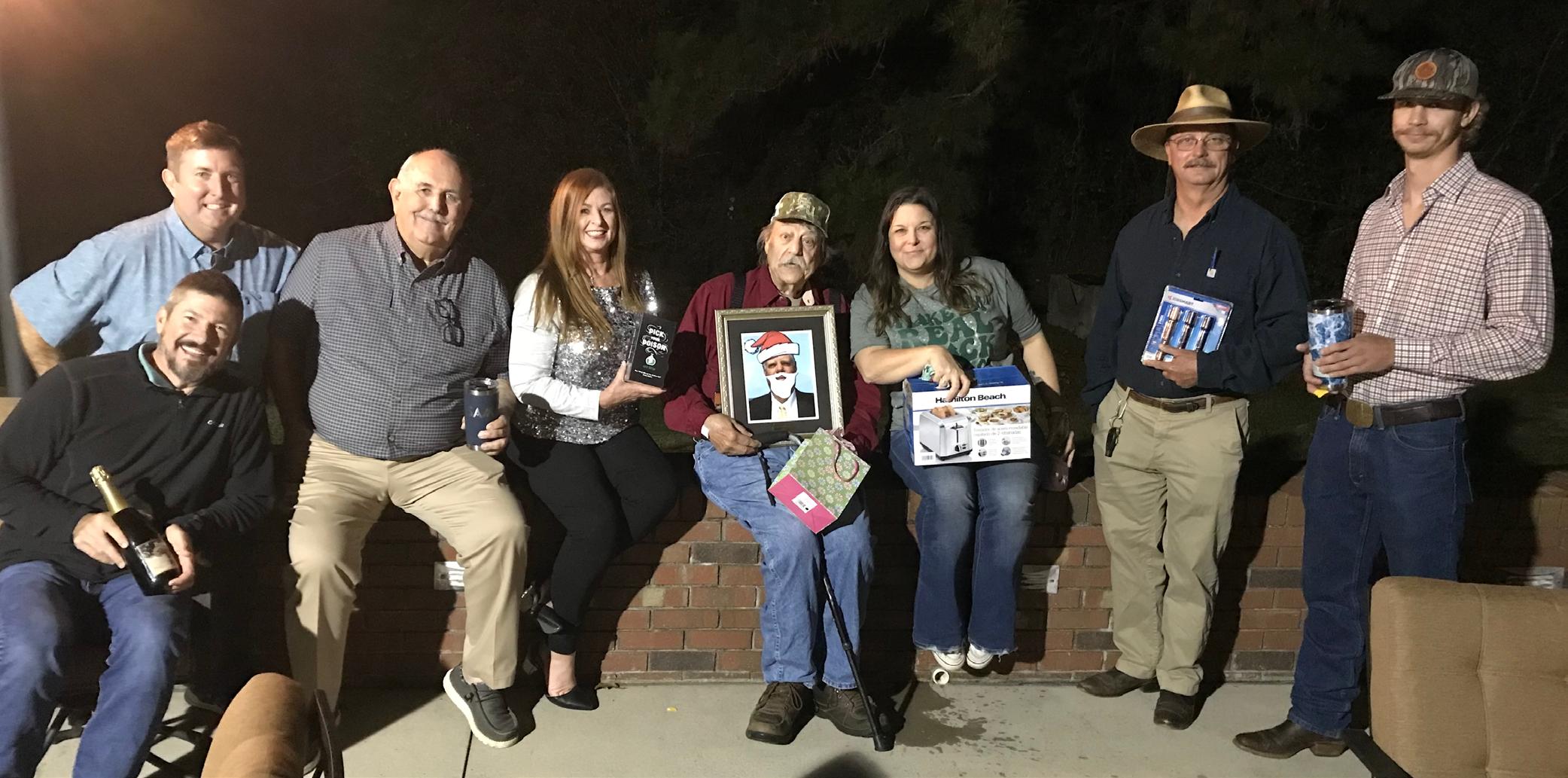

Pam Nobles opening her “ Secret Santa ” gift during the NW FL Chapter Christmas party.
Below: NW FL Chapter members posing with their “Secret Santa” gifts.
The Florida Surveyor Page 37
Why Join FSMS?
LegisLative support –
The Legislative Committee and our Lobbyist are committed to keeping the Public and the Surveying and Mapping Profession protected
educationaL Benefits –
With recently updated courses, getting your CECs has never been better
networking –
Attend our Annual Conference to meet other professionals and meet vendors with all the latest equipment sociaL Benefits –
Attend local chapter meetings to meet individuals with common professional goals
Florida Surveying & Mapping Society
1689 Mahan Center Blvd. Suite A Tallahassee, FL 32308 www.fsms.org (850) 942-1900
January 2023 Page 38 Aug/Sept 2021 30
CLICK HERE TO JOIN!
Join NGS at the 2023 FIG Working Week in Orlando, Florida
NGS is excited to announce that we will be presenting a full-day’s worth of content on the National Spatial Reference System (NSRS) Modernization during the FIG Working Week 2023 meeting, taking place at the end of May 2023 in Orlando, Florida. For the first time in over 20 years, this annual gathering of the International Federation of Surveyors will be taking place in the United States, hosted by the National Society of Professional Surveyors (NSPS). Click here to register now!

“The International Federation of Surveyors (FIG) is a United Nations and World Bank recognized non-governmental international professional organization. FIG was founded in 1878 and represents national associations of surveying, cadastre, valuation, national mapping professionals, geospatial experts and quantity surveyors working in both the public and private sectors, in the scientific, research and academic community, as well as from technology innovators and industry from more than 120 countries around the world.”
The 2023 Working Week will be an exciting week-long conference that brings the international community of surveying and geospatial professionals together for a mix of technical sessions and workshops, a trade exhibition and a variety of side events and
The Florida Surveyor Page 39
social functions.
On Wednesday, May 31, 2023 , NGS Director Juliana Blackwell will give a keynote address to the full conference and NGS staff will host a series of sessions on our efforts to modernize the U.S. National Spatial Reference System. More information will be posted to the NGS FIG 2023 webpage as it becomes available.

We encourage you to attend as much of the Working Week as you can, and be sure to join us on the Wednesday after Memorial Day to talk to NGS staff about NSRS Modernization.

January 2023 Page 40
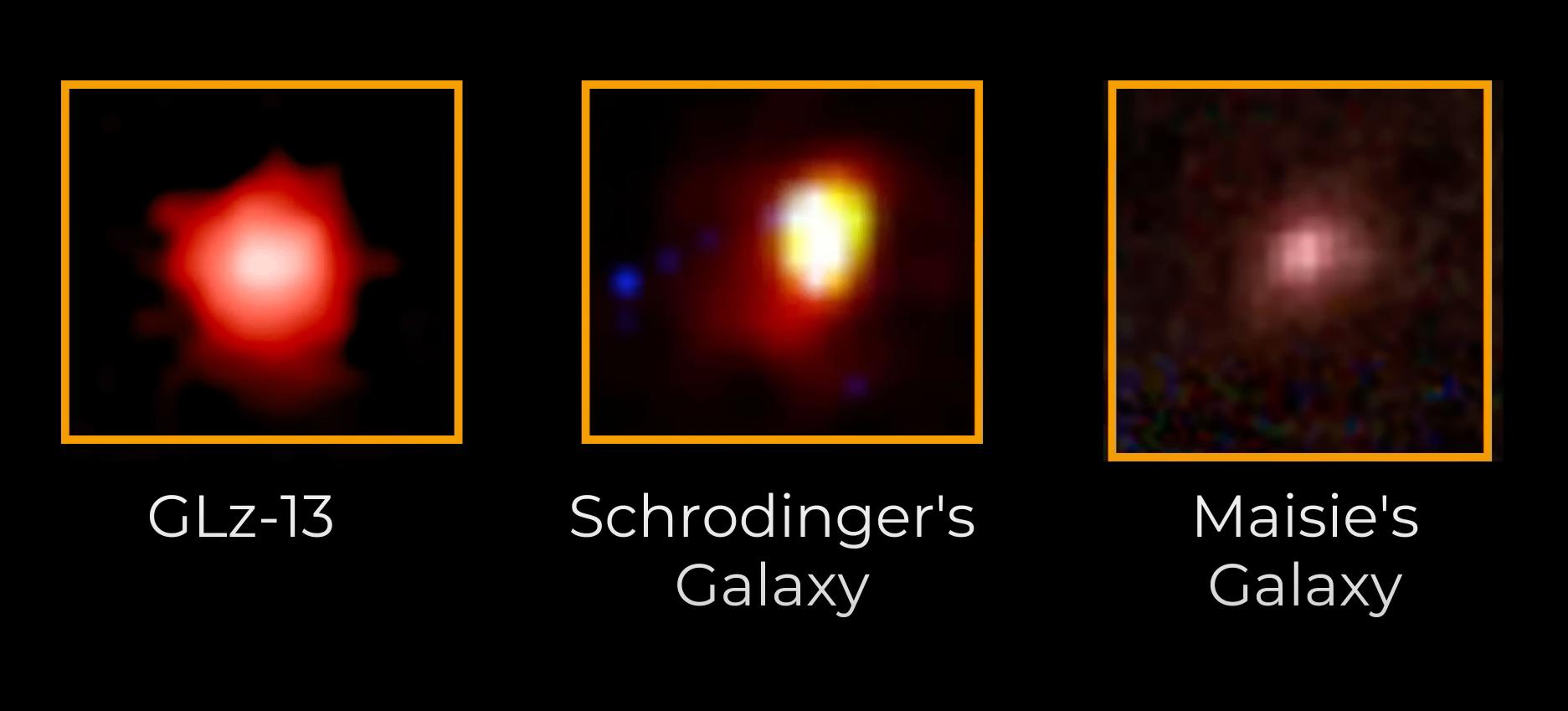
Biggest Breakthroughs in Astronomy and Physics from 2022


The Florida Surveyor Page 41
LAND WATER
With the help of Frontier Precision, places you once couldn’t imagine measuring are now a daily reality. Frontier Precision leads the way in Unmanned technology – through the air, land, and underwater. Every place on earth is now reachable – with UAS from DJI, Autel, Parrot, Ascent, and ROVs, Pipe Crawlers, and Utility Crawler solutions from Deep Trekker. Count on us to deliver the latest technology to help you get your job done e ciently and accurately while driving your profits. Today, no mission is out of reach.


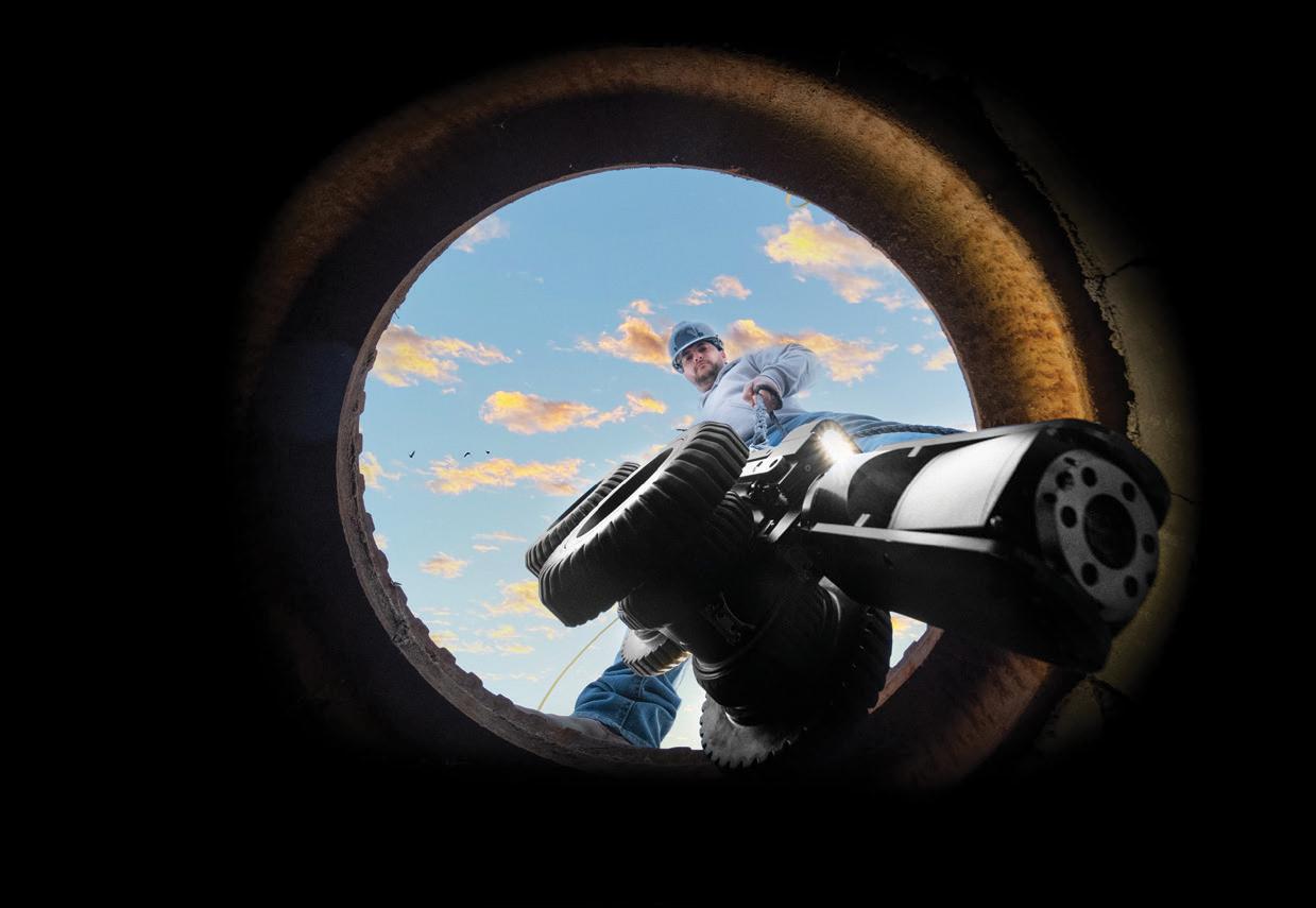
FRONTIER PRECISION | JACKSONVILLE
8301 Cyprus Plaza Drive, #107 Jacksonville, FL 32256
OU T M O RE A T : W W W .FRO N T IE
C
/ U N M
D P R O DUCTS | T R AINING | RE PAIR | REN TA L S | T
A
SE R
S
FIND
RPRE
IS I ON.CO M
A NN E
ECHNI C
L
VICE
AIR
ARCHIVES FROM THE
The Florida Surveyor Page 43
The Map as a Talisman— Different Ideas in Early Mapping
by Dr. Irene K. Fischer
When the emperor visited the legendary goddess of the West and saw there the important, top-secret “Map of the True Topography of the Five Sacred Mountains,” he begged and persuaded her to give it to him. He was told that it had been made by “The Highly Exalted Taoist Adept of the Three Heavens” to aid the holy immortals. It showed the differences in length and width among the rivers and seas; the differences in height among hills and mountains; and the central position of Mt. Khun-Lun where the immortals dwell. By the use of the carpenter's square and compass the rivers and their upper reaches had been measured and the mountains drawn with curving lines. The height and extent of the mountain slopes were shown by lines turning and curving that looked like written characters. Thus, the written names of the mountains were determined by their natural shapes. The diagrams of these shapes were kept secret, serving as charms and talismans among the immortals to pass safely over mountains and rivers .
—Paraphrased and abbreviated from a 4th century Taoist story called “Inside Story of the Emperor Han Wu Ti.” After J. Needham.
(Originally published June 1982 in Surveying and Mapping.)
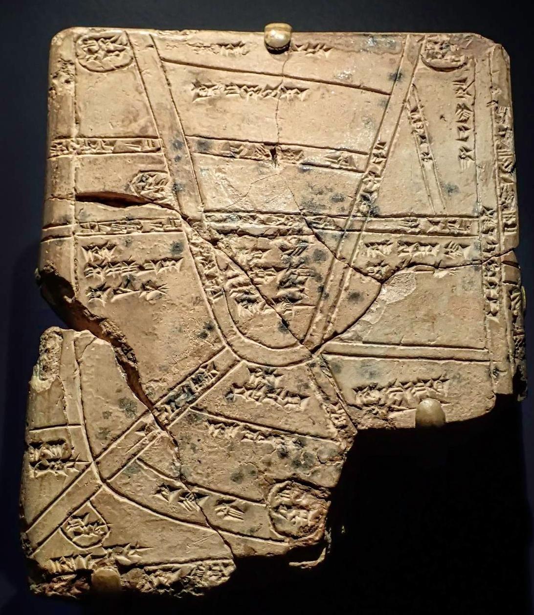
The Oldest Maps
Among the excavations at Nuzi (in Iraq) by the Harvard-Baghdad School Expedition in 1930-31, a clay tablet with a map on it was found, dating from the late 3rd millennium: the oldest map discovered so far. Its edges are marked “east,” "north,” “west,” but the fourth side is broken off. A big river, named “the fructifier” runs through the middle of the map, and its tributaries are shown as well as two mountain ranges approximately parallel to the river on either side. There are four circles indicating cities. The one in the middle of the map next to the river
is accompanied by the information that an area of a specified size is “cultivated land belonging to Azala.”
Of the city names inscribed within the circles, only the one in the northwest corner near a shoreline is completely preserved and legible as “Settlement of the fortress of Ebla.” The area shown on the map was unidentifiable at the time and taken to be possibly somewhere in the vicinity of Nuzi. Several decades later, the spectacular finds at the excavations of Tell Mardikh near Aleppo, about 400 mi. west of Nuzi, identified that Tell as the seat of an ancient powerful empire Ebla. About
January 2023 Page 44 of ancient surveyors, geodesists, mapmakers, explorers and their maps
The Map as a Talisman— Different Ideas in Early Mapping
20,000 tablets of the 3rd millennium have been unearthed there in the 1970s, but only a small fraction has yet been deciphered; enough, though, to let Ebla emerge as an important cultural and political center with farflung connections. This incredible find of the royal archives contains lists of geographical place names. It stands to reason that somewhere among these not yet processed treasures, maps also will appear which locate these place names and which must have served as aids to know the roads and landmarks for trade as well as military purposes. Since Ebla was destroyed by the end of the 3rd millennium, the date of such maps would seem clear.
The British Museum has an example
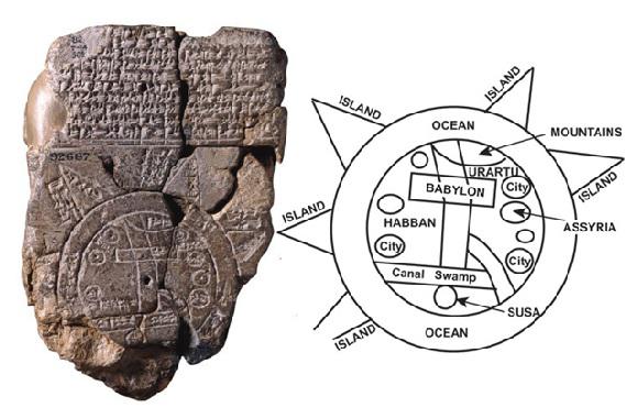
of an ancient Babylonian map (7th cent.) of a very different type. Near its center there is a rectangle marked Babylon; another rectangle, roughly perpendicular to the first and slightly bent in the middle, is not marked but might possibly represent the Euphrates; on either of its ends, there is a simple indication of mountains and a swamp, respectively. On the remaining sides, there are several small circles representing cities without names, one circle indicating “Assyria.” The whole is enclosed in a wide circular ring representing the ocean, beyond which there are a few triangular extensions called “zones,” and some distance information between them. The text on the back of the tablet speaks of seven zones between this earthly ocean and
The Florida Surveyor Page 45
Babylonian World Map (6th-7th century) courtesy of The British Museum
the heavenly ocean. They are marked: “where the sun is not seen,” dwelling of a “hostile horned bull,” “where the sun rises,” “semi-obscurity reigns,” etc. This highly stylized world map is representative of ancient so-called discoidal (disk-like) world maps or wheel-maps. Obviously, its purpose is different from that of the Ebla map: It is not to give travel information on how to go from, say, Babylon to another city, what landmarks to look for, where to expect mountains or rivers, i.e., practical information that would be improved with more travel experience; but it is to teach you the place of your neighborhood within the universe and how to picture that universe. Naturally, what you know best, your country is near the center of the universe, the ends of which are lost in the earthly and heavenly waters.
The third type of ancient maps in our possession are those of local scope: district maps, town plans, estate or field plans, canals, ground plans of houses, etc. (3rd mill.), some only in fragments but with identifiable features. Among the Babylonian maps there is, for instance, a clay tablet representing part of the city of Nippur, apparently the temple area of the earth god Enlil It shows the winding surrounding wall with several gates, a terrace and a moat beyond the wall, a canal further out and another across the middle, and the location of a few important houses. Another map shows
part of a ground plan of a building, maybe a royal palace, with specific measurements. Ancient building plans with measurements should not surprise us since we know of the numerous mathematical survey exercises on Babylonian cuneiform tablets of the 3rd millennium. Egyptian survey exercises are contained in the Rhind Papyrus (2nd mill., British Museum) and there exist papyri with plans of the Nubic gold mines and of a small region in Lower Egypt.
The pictographic character of Chinese writing and specifically the very ancient signs for mapping objects such as mountains (three peaks), a river (flowing water), fields (subdivided rectangles), country boundaries (mouth and dagger-axe, meaning eaters and
January 2023 Page 46
Dr. Irene K. Fischer
Babylonian Clay Tablet courtesy of Mary Harrsch

The Florida Surveyor Page 47
defenders), etc., make it plausible that an innate inclination towards visual response and recording encouraged early Chinese mapping. Ancient geographical-historical texts are so detailed and specific that they suggest the one-time existence of an underlying map.
Chinese mapmaking seems to go back to the 2nd millennium. One of its most impelling incentives was the need to regulate the flow of the Yangtze and the Huang-Ho or Yellow River, and to discover and record the connections between several branches. Regulation of the waterways including the construction of an adequate canal system for irrigation in an agricultural economy was one of the most important responsibilities of the ancient Chinese emperors and, as under the similar conditions of Mesopotamia, conferred power to the administrators, the representatives of the emperor or the priests respectively. The fundamental importance of the water systems is acknowledged and beautifully expressed in the deification of “Yü the Great,” a semi-legendary hydraulic engineer emperor, credited with inspecting one after another of the traditional nine provinces to set them right, as well as mastering the waters by regulating specific rivers, tracing out the high mountains, felling trees to utilize forests, and putting lands to their proper use according to their soils.
From the responsibilities of the administrators evolved the need for a widespread bureaucracy charged with recording —mapping— the local geographic details (local physical features and land use) and reporting them back to the central authorities. Local maps were combined with maps of provinces and these formed the bases for comprehensive world maps showing the most important geographic features and the extent of the then-known Chinese world. A. Herrmann reconstructed such a world map from the text of the “Yü-Kung” (Tribute of Yü), an ancient, surprisingly detailed geographical document of disputed age (at least 5th cent.) but of pervasive influence throughout the ages.
Another ancient book (7th cent.) has been regarded as the text connected with the “Nine Cauldrons,” symbols of sovereignty, which Yü the Great had cast with pictures or maps of various distant regions and the strange things found there; the Nine Provinces had contributed the metal. In this way, travelers would learn beforehand what to expect in those regions and thus could avoid adversities from and offenses against the various local material and spiritual things both good and evil, as well as travel in peace and without fear. The cauldrons were in the possession of the kings and stayed with them if they were virtuous and carried out the will of Heaven.
January 2023 Page 48
Mapping
The Map as a Talisman— Different Ideas in Early
The Map as a Talisman— Different Ideas in Early Mapping
The intriguing idea that maps giving advanced information about the wild unknown, and are endowed with the protective power of a talisman, is even more explicitly told in the story of the topography of a mountain becoming its written name.
The Wheel-Map Tradition
The two different types of ancient Babylonian mapping mentioned earlier, such as the city and palace plans with measurement information versus the discoidal world map (wheel-map) with Babylon at its center, have been characterized as quantitative or prescientific cartography versus symbolic or religious cosmography. Their intent and purpose were clearly different: In one case, practical information was given to help you find your way or give instructions to a builder, while in the other case the mapping objects were indicated only symbolically; no attention was paid to proportions or completeness which seemed irrelevant when contemplating the universe with particular stress on the inaccessible “beyond.” These two types of ancient mapping are not just interesting by themselves but are significant as precursors of two traditions that continued through many centuries in both the East and the West, though with a different emphases at different times.
In Europe, the wheel-maps were represented in numerous examples
during the Middle Ages to the exclusion of scientific cartography. These strange mappa mundi (maps of the world) are just as schematized as the old Babylonian wheel-map. In many of them, the so-called “T O maps,” the Mediterranean Sea is shown as just a vertical line in the lower half of the wheel, East (and sometimes pictures of the Paradise) being at the top of the map. Together with the rivers Don and Nile shown as one horizontal straight line from north to south, this forms a T within the O of the wheel. Often Jerusalem, in lieu of Babylon, is at or near the center. T-O maps were still around in the 17th century. Arabian T-O maps were often centered on Mecca and highly schematized to the point where all resemblance to actual geographic features was lost.
In East Asia, the religious wheelmaps centered around one or more legendary sacred mountains, mainly Mt. Khun-Lun (north of Tibet) and Mt. Meru or Kailas (Trans-Himalayas). The concept of the sacred mountain is of very ancient religious significance representing the mysterious potency of the earth as personified in the earth deity. In Mesopotamia, the earth god Enlil rather than the sky god Anu had emerged early as the supreme god, the god of the soil, the source of fertility. His most sacred shrine was the ziggurat at Nippur, of which a map is preserved as described above. Other city deities such as Marduk of Babylon or Tammuz,
The Florida Surveyor Page 49
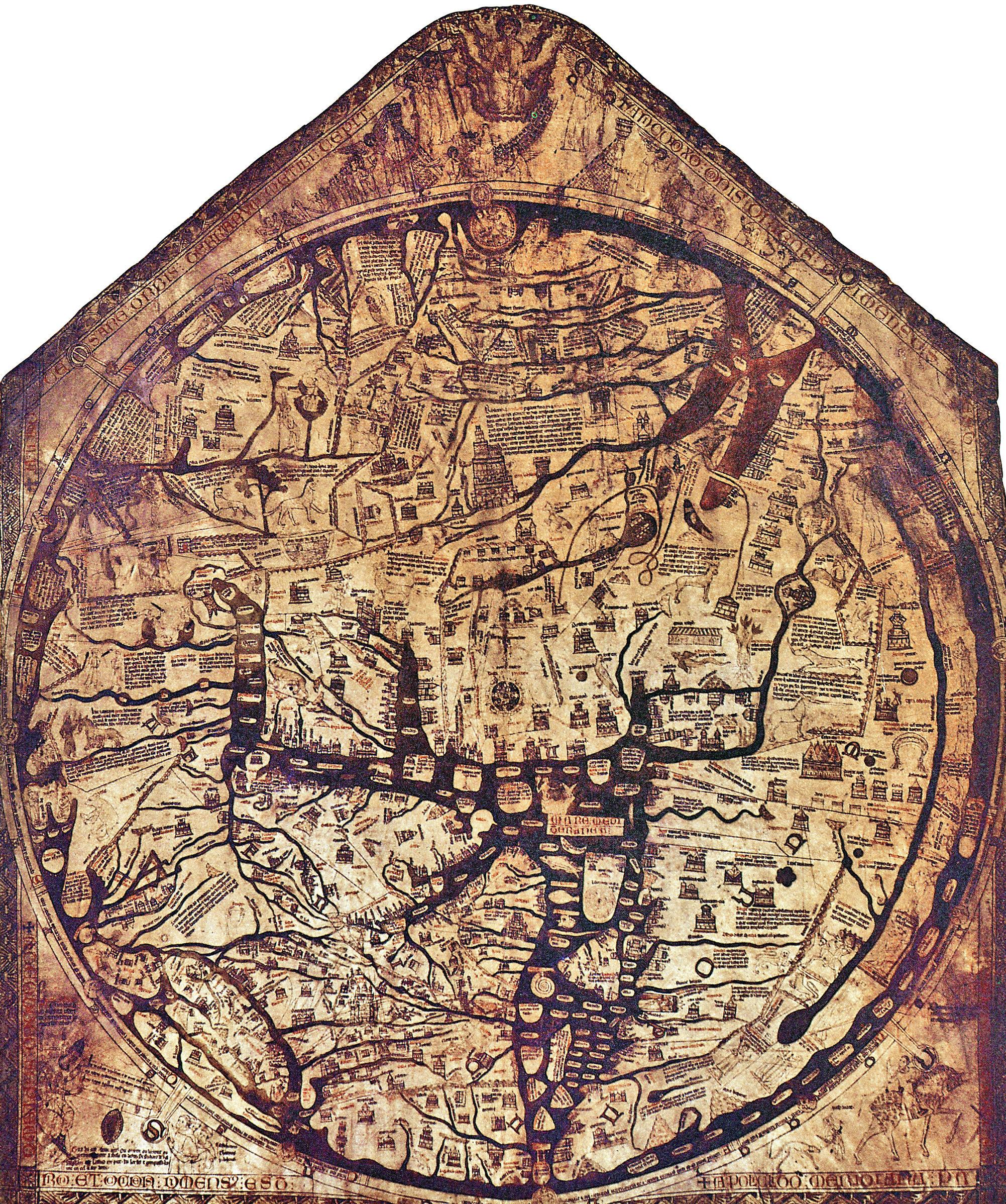 Hereford Mappa Mundi
Dr. Irene K. Fischer
Hereford Mappa Mundi
Dr. Irene K. Fischer
Map as a Talisman— Different Ideas in Early Mapping
were essentially local manifestations of Enlil Ziggurats were sometimes called “Mountain of God” or “House of the Mountain,” signifying them to be reduced symbols for the actual mountain. They were not originally, as sometimes said, means to worship gods in “high places” in the sense of nearer to heaven, but an artificial mountain in lieu of the mountainous place of concentrated activities of the chthonic forces.
In India, the earth god Siva bears the significant name of mountain lord, and his spouse the name of the daughter of the Himalayas, connecting soil and fertility with a sacred mountain, Mt. Meru. Ancient Chinese worship of the chthonic powers took the form of worship of the First Ancestor, and of mounds accessible to the people and a private one for the ruler, all symbols for Mt. Khun-Lun. The fundamental importance of the earth's energies is complemented by the great life-giving rivers originating in these sacred mountains; the Yellow River and the Yangtze from Mt. Khun-Lun, and the Ganges, Brahmaputra, and Indus from Mt. Kailas, still today a center of pilgrimage. The Babylonian parallel is the biblical story of the river flowing out of Eden and separating into four branches: Pishon, Gihon, Tigris, and Euphrates.
Reconstruction of Hecataeus' Map (550-476 BC) courtesy of digitalmapsoftheancientworld.com
While the significance of the sacred mountain was common in ancient East Asia, the wheel-maps of Babylonia by far the oldest, may have inspired that tradition in the West as well as in the East, reaching India, then China, and then Korea and elsewhere.
Early Scientific Cartography in the West
The story of early mapping in the West is well-known to our readers. It may suffice to briefly recall a few of the milestones and the direction of purpose in order to have a reference of comparison with the less well-known developments in the East.
The Florida Surveyor Page 51
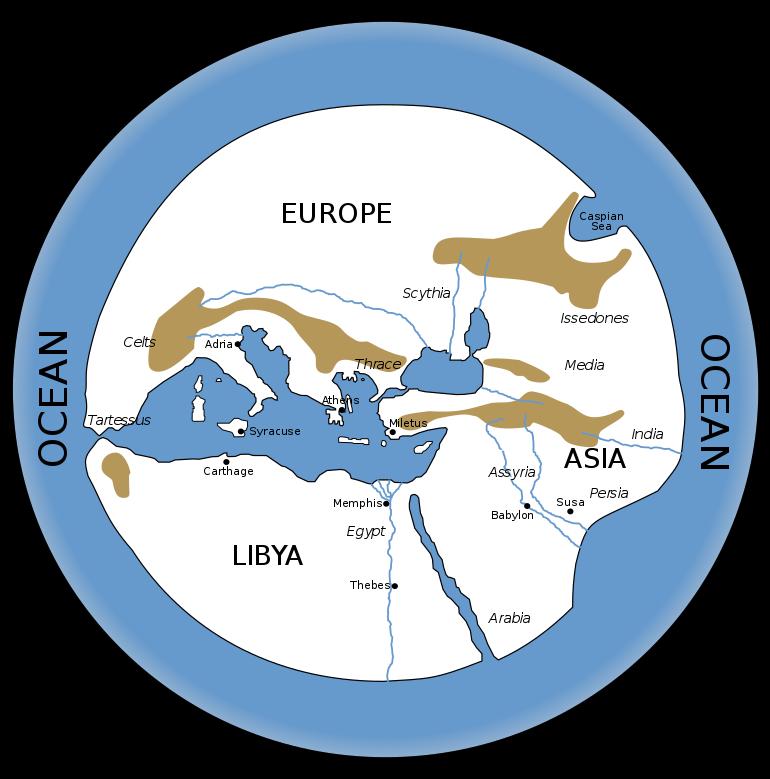
The
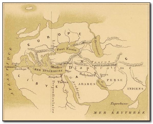
Anaximander of Miletus (6th cent.) is credited with producing the first map of the earth or rather of the oikumene as known at his time: It comprised the Mediterranean region from the Pillars of Heracles to the Caspian Sea, with the center at Delphi, Greece, the site of the “navel of the earth.” More geographic information beyond its eastern end is shown on the map by Hecataeus of Miletus (c. 500) which reached India and thus moved the map's center eastward from Delphi to Byzantium. More information from north and south, accumulated from tales of travelers, was pieced together for improvements and expansions in later maps of the known world. Dicaearchus of Messina (4th cent.) first organized this material by drawing an east-west reference line through various known places along the Mediterranean shore. Eratosthenes (3rd cent.), with whom the story of scientific geodesy usually
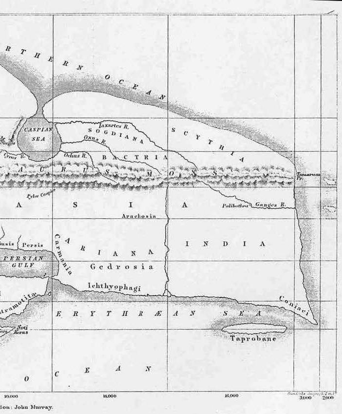
is said to begin, compiled his map of the earth systematically with respect to the backbone of two principal lines: Dicaearchus' east-west line and, intersecting it at Rhodes, a principal north-south line through Lysimachia, Rhodes, Alexandria, Syene, and Meroe. He calculated the size of the oikumene section by section along these lines and found it to be about twice as long in the east-west extent than in its north-south width. These dimensions were therefore called “longitude” and “latitude,” which is Latin for “length” and “width” respectively. He also used three more major parallels, namely the equator and the two tropics, and a number of auxiliary meridians and parallels through known places.
The most significant aspect of Eratosthenes' mapping was the same basic approach as in his famous determination of the earth's circumference: The correspondence between a celestial arc measured by an angle of astronomical latitude difference, and the terrestrial arc underneath measured in linear units (“stadia”) produced a conversion factor between the two related distances. The usefulness of such a conversion factor for mapping new information collected in one or the other form is quite obvious yet burdened with the variety of stadia in use (comparable to
January 2023 Page 52
Dr. Irene K. Fischer
World According to Dicaearchus of Messana
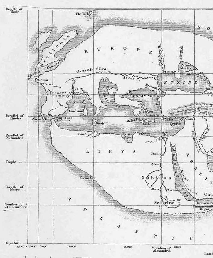
The Florida Surveyor Page 53
The World According to Eratosthenes of Cyrene
January 2023 Page 54
Antique Map
World by Ptolemy
World by Ptolemy Antique Map
The Florida Surveyor Page 55
of
of
of the Ancient Ptolemy (1730) of the Ancient Ptolemy (1730)
January 2023 Page 56
our own jungle of feet, statute miles, nautical miles, meters, yards, etc.).
Hipparchus (2nd cent.) tried to overcome the nuisance of different stadia by proposing the first uniform world coordinate system for drawing the map of the earth: Astronomical latitudes and longitudes should be the defining
parameters for every place, and he began collecting and tabulating such data, including the celestial phenomena visible at the inhabited places at various latitudes. He also was the one who introduced the Sumerian system of 360 degrees in a circle in lieu of the 60 hexacontades which Eratosthenes had used. And he also suggested the use of a conical projection.
The Florida Surveyor Page 57
Marinus of Tyre (1st and 2nd cent.) introduced a further milestone into mapping: A rectangular frame of straight-line meridians and parallels at regular intervals (one hour or 15 degrees in longitude and probably half an hour in length of the longest day in latitude) with an appropriate ratio of stadia to a degree along the parallels.
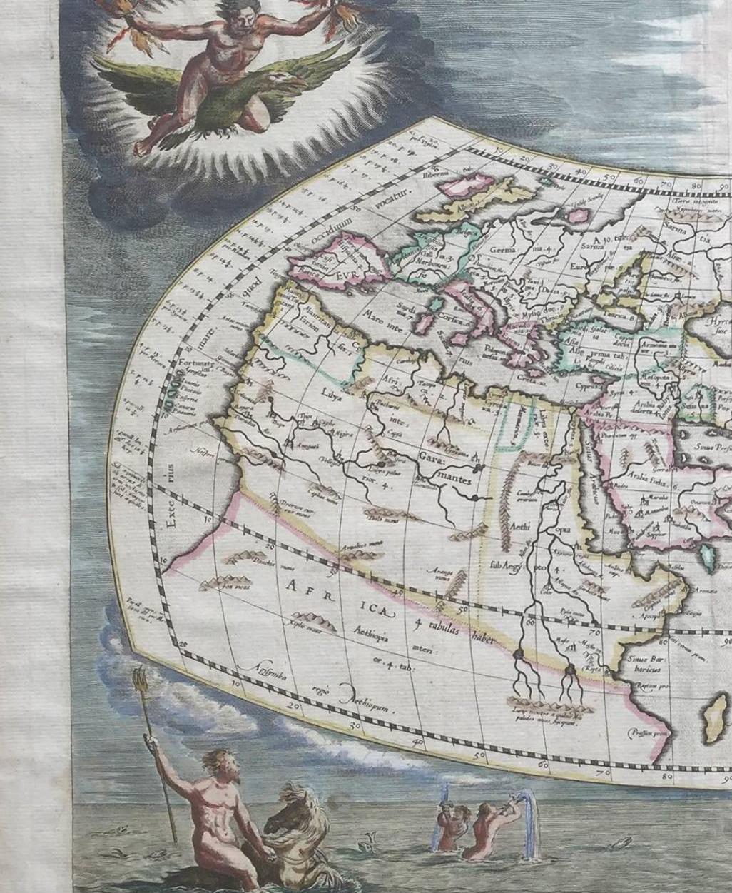
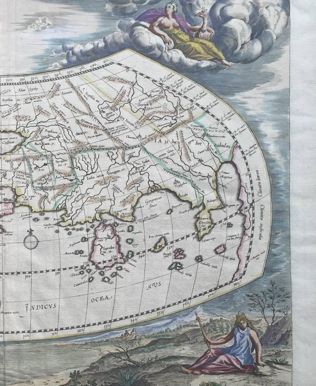
He also extended his map coverage east-ward by including information from merchants traveling the Old Silk Road from China. Ptolemy (2nd cent.) refined Marinus' map by analyzing and correcting distance reports as to the credibility of their sources (especially reducing Marinus' overestimate of Asia's length), and by extracting map
January 2023 Page 58
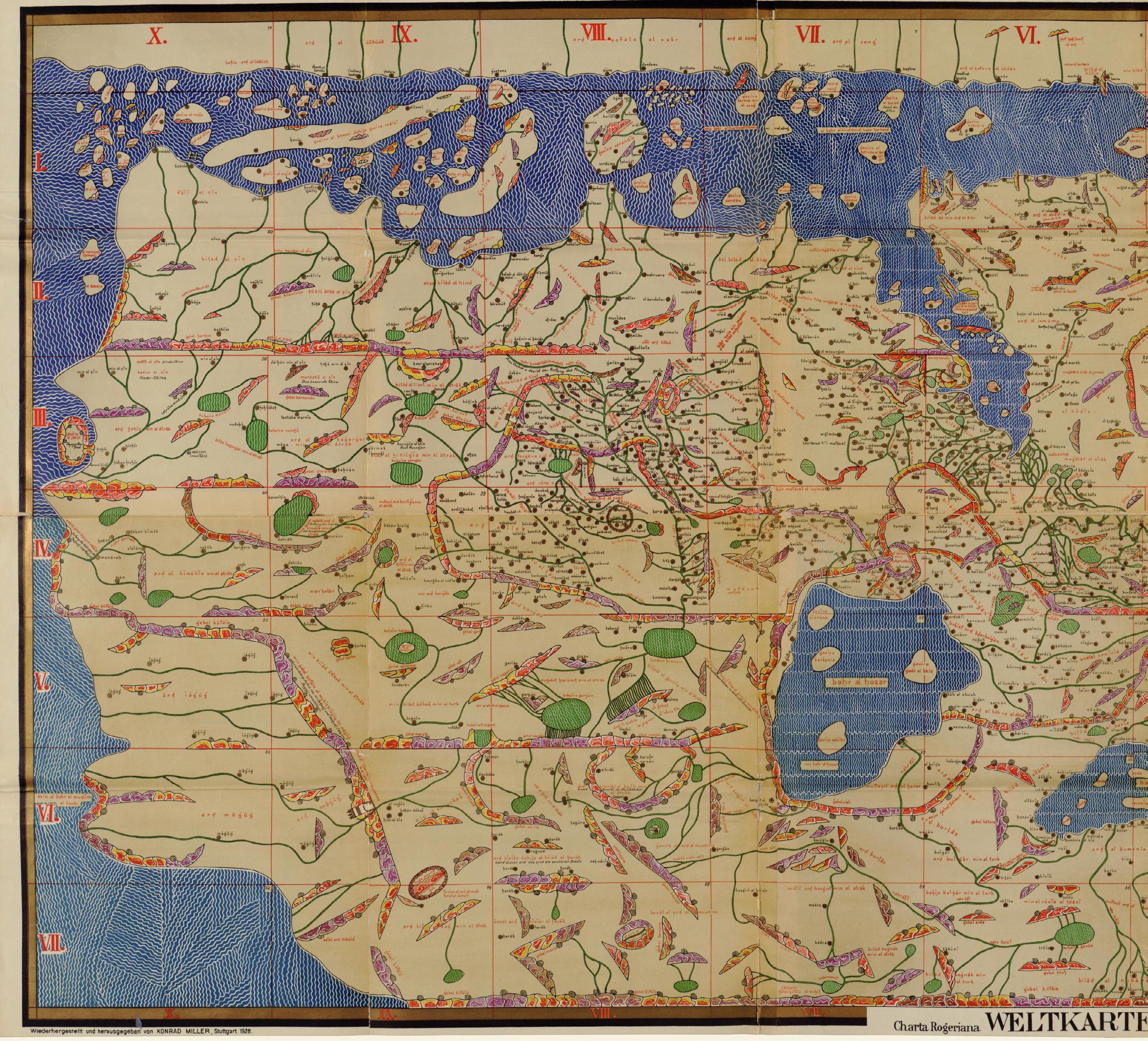
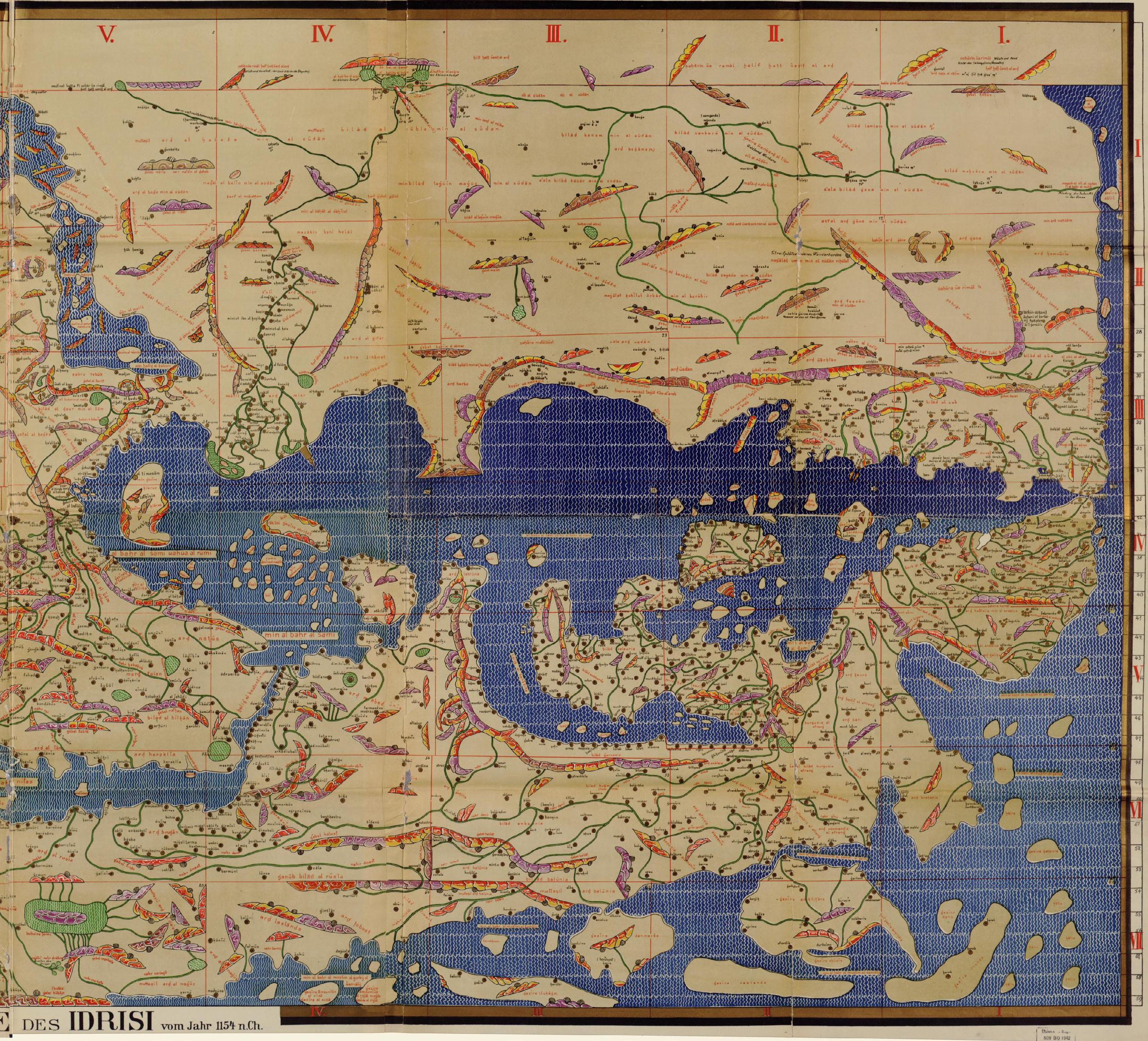
The Islamic World Map of 1154; courtesy of Library of Congress
Map as a Talisman— Different Ideas in Early Mapping
distances from nonlinear travel routes. He also tried Hipparchus' suggestion of using a map projection with curved-line meridians and parallels in his largest world map but retained Marinus' rectangular grid for smaller areas.
The cartographic problem of mapping the curved surface of the earth on a sheet of paper was much discussed, as one can tell from Strabo's elaborations in his Geography. “To represent the world correctly,” he writes, “one needs a globe of at least ten podes (Greek feet) in diameter. Otherwise, on a plane surface of at least seven podes, one could draw straight lines to represent the circles of the parallels and meridians. It does not matter that meridians converge to the pole while shown as straight lines perpendicular to the parallels, for our imagination can easily transfer to the globular and spherical surface the figure or magnitude seen by the eye on a plane surface.” But he warns that it takes a certain level of education to understand such maps: “The mere drawing on one and the same plane surface of Iberia and India and the countries between them gives to the man who has previously learned of the arrangement and movement of the celestial bodies and grasped the fact that the true surface of the earth is spherical but that it is depicted for the moment as a plane surface for the convenience of the eye, gives to him
truly geographic instruction, but to the man not thus qualified, it does not.”
The development of cartography in the West was driven by the Greek curiosity about the earth and their goal of drawing a map of its surface. Under the influence of astronomy, a coordinate system corresponding to celestial subdivisions was developed for the earth, whose spherical shape led to the problems of map projections. It was a straightforward development from Anaximander to Ptolemy, which was suddenly interrupted by the rise of Christianity and the exclusive predominance of the religious wheel-maps – no coordinates, no length proportions, fewer and fewer connections between geographic features and symbolic, stylized representations, a total rejection of Greek scientific interest in this world.
It was not until the end of the 13th century that the practical needs of seafarers produced sea charts (socalled portolans) showing shores with ports and coastal towns, as well as a network of compass directions with some scale information serving as a sort of coordinates. Eventually during the Renaissance, the cartographic thread which was cut off after Ptolemy was picked up again.
During the long anti-scientific era in the West, it was the merit of the Arabians to preserve some of the
The Florida Surveyor Page 59
The
achievements of antiquity, as in various cultural disciplines so also in cartography. The name of Caliph alMamum (9th cent.) is well known to geodesists because of his recalculation of the earth's circumference by Eratosthenes' method, having ordered to measure with special care one latitude degree in the plain of the Euphrates near Baghdad for the purpose. He also ordered to have lists drawn up of places with their latitude and longitude location following Hipparchus' proposal. The famous world map of al-Sharif al-Idrisi of 1150 continued the Marinus and Ptolemy tradition with nine parallels and 11 meridians, but on a flat earth; oriented with South on top, it included new information about the East, gathered from itineraries of the 9th and 10th centuries, but China beyond the Great Wall was still a blank. A set of 14thcentury maps of Iran show rectangular grids as used in China, and give place names instead of geographical features, the so-called “Mongol style” maps, indicating connections between East and West. Parallel to these developments, there also were a great number of Arabic T-O wheel-maps, some extremely stylized without any connection to real geographic features. Most were centered at Mecca (instead of Jerusalem, Mt. Khun-Lun, or Mt. Meru).
Cartographic Beginnings in the East Chinese mapping also produced the
two strands of pre-scientific maps and religious wheel-maps, but the latter never became so dominant as to interrupt the development of the former. Some of the earliest maps such as the two mentioned earlier (the topography of a sacred mountain, and the nine cauldrons) may in a fashion be counted as precursors for both strands, considering that their intended content was real geographic information while the medium of transmitting it took the form of spirits and talismans.
There are several significant differences between early eastern and western cartography. Both cultures had derived the spherical or at least curved shape of the earth from astronomy: The Greeks by noting the change in visible celestial phenomena when traveling relatively short distances northward, and the Chinese by noting the circumpolar stars turning around the celestial axis, and by extending the same motion to the other stars to complete their rotational orbits below the earth. But only the Greeks made the connection between the spherical earth and cartography, getting involved in the problems of mapping a spherical surface on a flat sheet of paper. Chinese cartography was based on a flat earth and thus not bothered with these problems. The reason was certainly not a lack of understanding but a difference in purpose and a practical sense of what is needed for that purpose.
January 2023 Page 60
Fischer
Dr. Irene K.
The Map as a Talisman— Different Ideas in Early Mapping
The purpose of the Greeks and of the West later on (Académie Royale des Sciences, 17th cent.) was to draw a map of the world for its inherent scientific interest. Maps of smaller areas were steps toward this larger goal. The purpose of the Chinese was to collect and record detailed geographic and economic information of the feudal principalities for administrative and military use, enhancing the power of the emperor to carry out “the mandate of Heaven.” An ancient text (“Records of the Rites of Chou”) tells, for instance, that when the emperor went on a tour of inspection, the Geographer Royal in charge of provincial maps was riding close to the imperial vehicle to explain the characteristics of the country and its products.— Another story tells how, after a battle in the 3rd century, while some generals were pillaging, one general searched the secretarial offices for all ordinances, reports, and maps, since such would be of inestimable advantage to the new rulers. (That sounds very modern, indeed; nothing on that scale is found in the West at that time.)— Underlining their importance as instruments of power, maps were part of court ceremonies as ceremonial symbols of sovereign authority. For example, maps of the empire were submitted to the emperor as part of the ceremonial investiture of three of his sons as feudal princes. And the possession of the ancient legendary Nine Cauldrons with their powerful quasi-maps was linked to the
righteousness of the ruling dynasty as a condition for its survival, as already mentioned earlier.
There were voices in either culture questioning the purpose and its legitimate scope. Strabo criticized Eratosthenes rather severely for starting his Geography with inquiries about the earth as a whole and what was outside the oikumene, thus wasting his time when he should have concentrated on describing the accessible countries around us. As the Chinese counterpart, we read of a criticism contained in a 1st-century report that ordinary scholars do not understand the vastness of Heaven and Earth, and the Tao of the universe, which is why the First Emperor wanted to reach the Nine Continents and the Great Ying Ocean. These scholars only worry over the affairs of their own small lands and have no idea of the great world of the empire. —In defense the scholars quoted Confucius: “People who do not know how to manage human affairs, how should they know about the affairs of the gods and spirits? Those who have not yet attained knowledge of that which is near at hand, how should they know about the Great Ying Ocean? Therefore, one should have nothing to do with things that are of no practical use. What is not concerned with government matters one should not investigate.”
Despite these refreshing symphonies
The Florida Surveyor Page 61

The Map as a Talisman— Different Ideas in Early Mapping
of opinions, the major trend persisted: The Greeks and the West were fascinated by studies of the world as a whole, while the Chinese wanted to support an efficient administration for the economic benefit of the people.
Since detailed local and regional administrative maps were the major cartographic objectives, a flat earth with a simple square grid was appropriate for the purpose. Also, the West (Marinus of Tyre, Ptolemy) used simple rectangular grids for areas of a limited extent, but these were deliberate approximations of the curved lines on the spherical earth. The Greeks' preoccupation with map projection problems stemmed from their predilection for abstract consistent systems with an eye toward comprehensive world maps. For the practical Chinese that goal was extraneous, and the difference in accuracy at that time was irrelevant for limited areas. Chinese cartography thus began and continued without interruption with rectangular grids, based on terrestrial distances in li, the linear unit.
Also, the names of the map coordinates are revealing: “ching” and “wei” are the terms for textile warp and weft. Maps were drawn on silk and the textile threads may well have been the means to locate a point for the correct painting. Such a map played a role in a dramatic assassination attempt
in 227: The king was to be presented with a district map, but a dagger was hidden in it as it was brought in, rolled up in its map case. (Relax! The attempt failed.) In a 3rd-century story, a girl mapmaker is mentioned who introduced improvements: The emperor was looking for an expert painter for a military map showing mountains, rivers, etc. The younger sister of the prime minister was recommended to him, and she suggested embroidering the map because painted colors would fade.
Weaving the map sheets may not have been the only reason for the use of rectangular coordinates. There seemed to have been an early tendency to use rectangular frames in general. Ancient land allotments were made in coordinate terms and the ancient written character for “field” was a little square subdivided into four equal sub-squares. In ancient Babylonian and Chinese mathematics, basic use was made of rectangular tabulation of numbers. The multiplication table, the “9 times 9,” is mentioned in an ancient Chinese text as the basis for everything else: “The combination of the right angle with numbers is what guides and rules the ten thousand things.”
There were also rectangular counting boards using columns for a place-value system in at least the 4th century. Such prevalence of thinking in rectangular modes makes it understandable that a schematic description of the spread of
The Florida Surveyor Page 63
Advertise With Us!
Benefits: Full color; hyperlinks added to your webpages as well as email addresses.
Requirements: Contracts for one year (11 issues) receive 10% discount if paid in advance; 15% for Sustaining Firms. (Ads should be in jpeg, pdf, or png format) New ads and/or changes are due by the 25th of each month.

Please email communications@fsms.org to notify us of upcoming events.
All advertisements contained within the publication are published as a service to readers. Publication of the advertisements does not imply or express any endorsement or recommendation by FSMS.
Size 1 Issue 2-11 Issues Full Page $720 $395/issue 1/2 Page $575 $320/issue 1/4 Page $290 $175/issue
civilization given in the classical “Yü Kung” (the oldest geographical survey) is traditionally interpreted in terms of concentric proportional rectangles (rather than in concentric circles as we might do): At the center is a rectangle representing the royal domains, surrounded in outward succession by the lands of the tributary feudal princes, then the “zone of pacification” (spreading Chinese civilization), then the zone of allied barbarians, and then the zone of cultureless savages. Also, the Greeks and Romans considered distant countries outside their own civilization as barbaric or savage (though not in a schematic rectangular distribution). Apparently, neither the East nor the West could imagine that trade connections from abroad might originate in an equally high civilization independent of their own.
The difference in Greek and Chinese cartographic objectives (global versus administrative and military) is expressed also in the much greater Chinese concern for detail. This is evident already when comparing the two oldest documents in both cultures. The map underlying the classical survey of the “Yü Kung” is much more elaborate than the roughly contemporary map of Anaximander. Concern for the great economic and strategic importance of the waterways and water conservation produced a detailed description of 137 rivers already in the 1st century,
Yü Chi T’u (Map Tracing the Tracks of Yü) 1136 80 x 79 cm (2’9” x 2’8.25”)
The map is carved into a monumental stone (stele). North is at the top. The grid was here used as a measure of the distance between administrative nodes. Rivers and mountains are named, prefectures from the past to the late 11th century are also marked. The stele is in the Shaanxi Provincial Museum, Xi’an, China.
in “The Waterways Classic.” It was enlarged 40 times its scope in the early 6th century in “The Waterways Classic Commented.” According to J. Needham's judgment, this important work has no parallel in Europe before the 16th century. Exploring and mapping rivers, lakes, and canals continue to play an important role in the following centuries. The source of the Yellow River was a repeated object of exploration in remote regions in the 7th, 9th, and 13th centuries. There also exists a great amount of
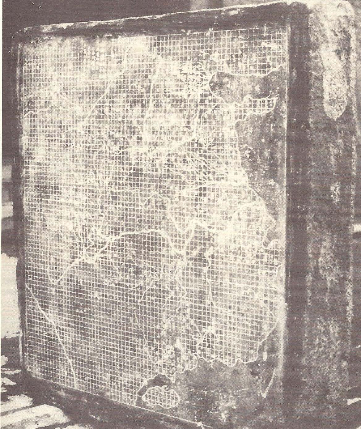
The Florida Surveyor Page 65
A “rubbing” of Yü Chi T'u (Map of the Tracks of Yü the Great), 1137 A.D. A rubbing from map carved in stone, actual size is about 3 feet square. Each square on the grid represents 100 li, or about 50 kilometers.
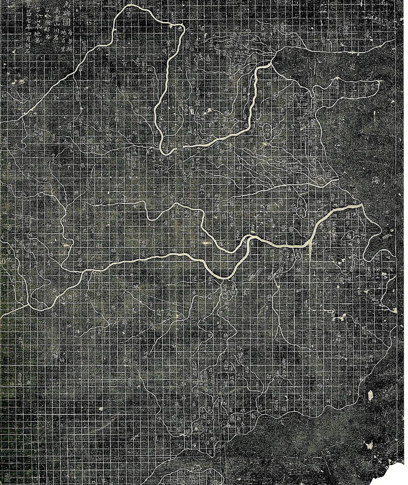
early topographical descriptions, “gazetteers,” that may or may not have been accompanied by maps; but a Map or Szechuan is mentioned as dating from about 150. At least since about 610, officials all over the country were ordered to produce local maps with their reports on local customs and products and to present them to the imperial secretariat.
Phei Hsiu (3rd cent.) is considered the father of Chinese scientific cartography. He made a critical study of the ancient texts and compiled a map (on silk!) in 18 sheets of what
he considered reliable information, though always with deference to the revered “Yü Kung,” and he presented it to the emperor who promptly locked it up as “secret.” (How modern!) Phei Hsiu explains and insists on certain principles for correct mapmaking: graduated divisions indicating the scale, a rectangular grid, pacing out the sides of right triangles (along the grid lines) to determine the distance between two points, and measuring elevations, angles, and curves according to the terrain in order to extract map distances on a plane surface.
Comparable discussions of proper cartographic procedures in the West might be associated with the names of Eratosthenes, Strabo, Marinus of Tyre, and Ptolemy, that is, already several centuries earlier. But while the Western cartography of rectangular grids and map projections broke off after Ptolemy for more than a millennium, the Chinese continued their cartographic tradition in 437, maps were inscribed in stone steles in the 6th century, and a grid map of the Western Kingdoms, dated 605 became famous. Other maps of that time are mentioned in the literature but were lost. In the 8th century, the eminent cartographer Chia Tan was commissioned by the emperor to prepare a map of the whole empire. This famous map (on silk), begun in 785 and completed in 801, was entitled “Map of both Chinese and Barbarian
January 2023 Page 66
The Map as a Talisman— Different Ideas in Early Mapping
Peoples within the Four Seas.” It was 30 ft. long and 33 ft. high, probably covering Asia on a 1:2 000 000 scale. Another map of that time showed all the fortified points and strategic locations north of the Yellow River and was hung up in the imperial baths so that the emperor could consult it daily. In 1137 two maps were carved in stone, about 3 ft. square in size; both still exist. One is entitled: “Map of China and the Barbarian Countries,” which has no grid, and represents the barbarian countries only by text; it may have been a partial reproduction of the previously mentioned 8th-century map by Chia Tan The other stone map is incomparably better. It is called: “Map of the Tracks of Yü the Great,” which has a grid, firm coastlines, and extraordinarily correct river systems. It appears to surpass in cartographic quality and also the contemporary famous Arab map by al-Idrisi of 1150. The first Chinese printed map is dated 1125, the oldest printed map anywhere. It is a map of West China, showing the river systems and the Great Wall. By contrast, the first European printed map is dated 1475 (Lucas Brandis in Lübeck) and is still of the T-O wheel type with no real geographic content.
Cultural Connections
The differences and similarities of cultural achievements in the East and West invite the question of whether a significant influence can be traced in one or the other direction. To
clarify such a question, one would distinguish between the physical possibility and likelihood of data and/ or concept transmission and the use of such transmitted information. For example, we may remember that Thales of Miletus traveled in Egypt and elsewhere where he learned some geometry from the Egyptian priests and heard of Babylonian astronomical observations; but he utilized this knowledge from abroad in starting a new specifically Greek edifice of geometry and astronomy.
Similarly in mapmaking, one can compare the type and quality of ancient maps as we know them or know of them from ancient texts and wonder to what extent they may have been influenced from outside. In the case of the wheel-maps where the typical features stayed more or less the same throughout the centuries except for adaptation to the various cultural symbols, without cartographic developments, it seems reasonable to assume a transmission along time sequence from Babylonia (known there since 3rd millennium) to India (1st mill.), and from there with the spread of Buddhism to China and further to Korea (until 18th cent.); and also from Babylonia to the West (5th to 17th cent.) and to the Arabians. In the eastern transmission line, Babylon as the center of the wheel was replaced in India by the sacred mountain Meru, and in China and Korea by the sacred
The Florida Surveyor Page 67
Dr. Irene K. Fischer
mountain Khun-Lun, both reflecting the significance of the mountain in ancient Asiatic religion. These maps show North on top. The Western transmission line replaces the city of Babylon with the city of Jerusalem. The orientation of the Babylonian maps conformed to the direction of the winds and have East on top. The maps centered on Jerusalem are oriented towards the biblical Eden in the East, showing it on top with pictures of the Paradise. An interesting crossconnection between the East and the West seems to appear in the “Christian Topography” by Cosmas Indicopleustes (540) who had traveled in India. He attacked “the wicked folly of the Greeks in geography” and made a highly stylized map of the universe with a huge mountain in the North (meaning Mt. Meru?) which hides the sun's path between setting and rising. Also, the Arabians provided a cross-connection. Though preserving some knowledge of Hellenistic cartography, they nonetheless produced geometricized wheel-maps (8th to 13th cent.) with East on top, often centered on Mecca or on a mythical city “Arim” (some 10° east of Baghdad), which they called “the cupola of the earth” suggesting an echo of Mt. Meru.
The development of the so-called quantitative or scientific cartography (in distinction to the religious wheelmaps) started several centuries earlier in the West than in the East. At about
the time of Ptolemy when the western development attained a certain height and then stopped in the face of the wheel-map predominance, the eastern development seemed to “take over” by gaining momentum in systematic procedures and critical analysis of data. Was that a coincidence in timing or a transmission? Trade communications and cultural exchanges between the Mediterranean area (Egypt, Greece, Phoenicia, Asia Minor, Rome) and the Near Eastern area (Mesopotamia, Persia, India) had intensified in the centuries before the common era. Indian trade is mentioned already in early Indian hymns; it led to cultural contacts and the spread of Buddhism beyond the borders in the 3rd century and became an important link in the international network of trade routes by land and by sea. The Far East with its autonomous culture had contact first with the steppe cultures of central Asia, whose nomadic people were involved in many far-roaming migrations reaching Europe, Persia, and India. Their conflicts with China ended with China's penetration into Central Asia in the 2nd century and the increased role of trans-Asiatic roads. Two roads across the Great Wall allowed trade with the West; the oases along the caravan routes served as commercial posts and naturally, also trafficked in ideas. The Chinese silk traders on the Old Silk Road communicated between East and West, as did the sea traders between Rome
January 2023 Page 68
The Map as a Talisman— Different Ideas in Early Mapping
and China via India. Chinese silk was well known and appreciated in Rome in the 1st century (first mentioned by Horace). Ptolemy knew of the various trade routes and included the information in his Geography Marinus of Tyre before him had already incorporated into his map information from traders across Asia. The first two centuries of the common era have been characterized as the first period in world history when Eurasia formed one great commercial area, which did not happen again until the 13th century in the Mongol period.
Thus, the physical possibility of transmitting Western cartography to China certainly existed; but even if Marinus' and Ptolemy's work had been known in China, it did not influence the Chinese tradition of rectangular grids which was essentially different from the Hellenistic use of rectangular grids; straight lines in linear terrestrial distance units versus straight lines as convenient approximations of curved parallels and meridians based on astronomical angle units. Considering the fact that the Chinese were excellent astronomers, they must have decided consciously or unconsciously, not to link the two types of measures, each of which had its advantage in its own realm. Such a conclusion is underlined by the further fact that the Chinese were well acquainted since most ancient times with the shadow-casting pole (gnomon) and used it for rough
north-south distance calculations but not for systematic cartography as did the Greeks.
With the decline of the Roman empire and the increasing insecurity of the roads, the lively east-west trade declined and trickled down to occasional contacts. Marco Polo's travel to East Asia in the 13th century is well known; less well known in Western literature are the several Chinese travels to Persia and Afghanistan in the same century, resulting in detailed descriptions of the journeys through Mongolia and Central Asia. The role of the Arabians as cultural intermediaries during the 9th to 14th centuries has been mentioned above. It is possible that the Arabians were also instrumental in transmitting the 8th-century Chinese invention of the magnetic compass to Europe where it became known around 1200 and made the 13th-century portolan maps possible.
The fact that the Chinese carried on the banner of scientific cartography through the centuries of Western decay was unknown to the West until the time of the Jesuits in the 16th and 17th centuries when Western Renaissance cartography reached China and Chinese geographical information reached the West. Curious about western data, the Chinese asked the Italian Jesuit Matteo Ricci in 1583 to draw for them a map of the world
The Florida Surveyor Page 69
While this map showed America which the Chinese had not known before, they were apparently less impressed by the curved meridians and hesitated to give up their traditional grid system which had served them so well for millennia. Many 19thcentury Chinese maps still show simultaneously rectangular grid lines along with latitude-longitude lines. Matteo Ricci's work has often been called an “enormous contribution to Chinese cartography,” but J. Needham thinks that this would not be fair to the Chinese. Such overvaluation may rather be another instance of a Western feeling of superiority in the face of a non-Western and different way of doing things.
References
Berger, H. (1903), Geschichte der wissenschaftlichen Erdkunde der Griechen, Leipzig, reprinted Berlin 1966.
Berger, H. (1906), “Die Lehre von der Kugelgestalt der Erde im Altertum,” Geographische Zeitschrift, 12. Brown, L. A. (1949), The Story of Maps, Little, Brown & Co., Boston. British Museum, Cuneiform Texts from Babylonian Tablets, Vol. 22. Herrmann, A. (1924), “Die ältesten Chinesischen Weltkarten,” Ostasiatische Zeitschrift, Vol. 11, Heft 2. Herrmann, A. (1930), “Marinus von Tyre,” Petermanns Mitteilungen, Ergänzungsheft Nr. 209, Gotha, Justus Perthes.
Karlgren, B. (1950), “The Book of Documents,” Bull. Of Museum of Far Eastern Antiquities, Stockholm, Vol. 22, 1. Maloney, P. C. (1978), “Assessing Elba,” Biblical Archeology Review, Vol. IV, Mar. Meek, T. J. (1935), Excavations at Nuzi, Harvard Univ. Meek, T. J. (1936), “The Orientation of Babylonian Maps, Notes and News,” Antiquity, 10. Mzik, H. V. (1938), “Des Klaudius Ptolemaios Einführung in die darstellende Erdkunde,” Klotho, Historische Studien zur feudalen und vorfeudalen Welt, Bd. 5, Wien. Needham, J. (1959), Science and Civilization in China, Cambridge Univ. Press, Vols. II and III Neugebauer, O. and A. Sachs (1945), Mathematical Cuneiform Texts, New Haven, Conn. Pareti, L. (1965), “The Ancient World,” History of Mankind, UNESCO, Vol. 2. Randles, W. G. L. (1980), De la Terre Plate au Globe Terrestre, Cahiers des Annales, Librairie Armand Colin, Paris.
Strabo (1917), Geogräphy, Eng. Transl. by H. L. Jones, G. P. Putnam’s Sons, New York.
Unger, E. (1935), “Ancient Babylonian Maps and Plans,” Antiquity, Vol. 9. Wales, H. G. Qu. (1953), “The Sacred Mountain in the Old Asiatic Religion, Jour. Royal Asiatic Soc. Woolley, C. L. (1928), Vor 5000 Jahren, Stuttgart, 12th ed., p. 69.
January 2023 Page 70
Fischer
Dr. Irene K.


The Florida Surveyor Page 71 Executive Director Rebecca Porter director@fsms.org Communications Coordinator Justin Ortiz communications@fsms.org Regional Coordinator Cathy Campanile seminolecc84@gmail.com Education Director Samantha Hobbs education@fsms.org ADMINISTRATIVE Staff
Past Presidents
1956
H.O. Peters
Harry C. Schwebke John P. Goggin
R.H. Jones
1960
Hugh A. Binyon Russell H. DeGrove Perry C. McGriff Carl E. Johnson James A. Thigpenn, III Harold A. Schuler, Jr. Shields E. Clark Maurice E. Berry II William C. Hart Frank R. Schilling, Jr.
1970
William V. Keith James M. King Broward P. Davis
E.R. (Ed) Brownell E.W. (Gene) Stoner Lewis H. Kent
Robert S. Harris
Paul T. O’Hargan
William G. Wallace, Jr. Robert W. Wigglesworth
1980
Ben P. Blackburn William B. Thompson, II John R. Gargis Robert A. Bannerman H. Bruce Durden Buell H. Harper Jan L. Skipper Steven M. Woods Stephen G. Vrabel W. Lamar Evers
1990 Joseph S. Boggs Robert L. Graham Nicholas D. Miller Loren E. Mercer Kent Green Robert D. Cross Thomas L. Conner Gordon R. Niles, Jr. Dennis E. Blankenship W. Lanier Mathews, II Jack Breed
2000 Arthur A. Mastronicola Michael H. Maxwell John M. Clyatt
David W. Schryver
Stephen M. Gordon Richard G. Powell
Michael J. Whitling Robert W. Jackson, Jr. Pablo Ferrari Steve Stinson
2010 Dan Ferrans Jeremiah Slaymaker Ken Glass
Russell Hyatt Bill Rowe Dale Bradshaw Lou Campanile, Jr. Bob Strayer, Jr. Dianne Collins
2020 Don Elder Hal Peters Lou Campanile, Jr.
Page 72
