UK | USA | Canada | Ireland | Australia
India | New Zealand | South Africa
Penguin Books is part of the Penguin Random House group of companies whose addresses can be found at global.penguinrandomhouse.com
Penguin Random House UK , One Embassy Gardens, 8 Viaduct Gardens, London SW11 7BW penguin.co.uk
First published by Penguin Michael Joseph 2024
Published in Penguin Books 2025 001
Copyright © Jack Cornish, 2024
The moral right of the author has been asserted
Penguin Random House values and supports copyright. Copyright fuels creativity, encourages diverse voices, promotes freedom of expression and supports a vibrant culture. Thank you for purchasing an authorized edition of this book and for respecting intellectual property laws by not reproducing, scanning or distributing any part of it by any means without permission. You are supporting authors and enabling Penguin Random House to continue to publish books for everyone. No part of this book may be used or reproduced in any manner for the purpose of training artificial intelligence technologies or systems. In accordance with Article 4(3) of the DSM Directive 2019/790, Penguin Random House expressly reserves this work from the text and data mining exception
Map illustration © Ian Moores, 2024
For picture credits see page 364
Set in 11.64/14.30pt Bembo Book MT Pro Typeset by Jouve (UK ), Milton Keynes
Printed and bound in Great Britain by Clays Ltd, Elcograf S.p.A.
The authorized representative in the EEA is Penguin Random House Ireland, Morrison Chambers, 32 Nassau Street, Dublin D 02 YH 68
A CIP catalogue record for this book is available from the British Library
ISBN : 978–1–405–95129–6
Penguin Random House is committed to a sustainable future for our business, our readers and our planet. This book is made from Forest Stewardship Council® certified paper.
This book is dedicated to all those who fight for public access and to preserve our paths – past, present and future.
And to my nephews, Max and Charlie – I look forward to walking alongside you, whatever path you choose in life.


Botallack Mine
Irish Sea


Newcastle
Keswick
Irton
Ambleside
Borwick
Treborth Botanic Garden
Liverpool 0
Manchester
Bangor
Llanberis
Town/village
Monument/landmark
RAF base
City North Sea
She eld York
Hull
Julian’s Bower
Fairbourne Llansant raid-ym-Mechain Bonsall
Nottingham
RAF Folkingham
Aberystwyth
RAF St Davids
Efailwen
Swansea
Cardi
Port Eynon
Birmingham
Ravenser Odd
Norwich
Seething Kettering
Droitwich Spa Daventry
Ely Cathedral Newmarket Racecourse
Oxford
Bath
Chittlehampton
Plymouth Exeter
Tintern Abbey Stonehenge
Avebury Henge Hailes Abbey
Southampton
Ansty
English Channel
Wotton Underwood
Berkhamsted Castle
Cambridge London
Canterbury
Crawley
Pevensey Castle
The Lost (and Not So Lost) Paths of England and Wales
Short path/point of interest City
At first glance, it’s not exactly the most exciting photograph I’ve ever taken. A photo of my trousers, dew-soaked from earlymorning walking through a wheat field, and my boots, moulded and cracked to the shape of my feet. But at this very spot, on a scree-strewn grey lane near the English–Welsh border, I’d walked exactly 500 miles. Behind me, a trek which had taken me along high cliffs, through woodlands, down valleys, over punishing hillsides and along city streets. Standing on that Shropshire lane, my feet were a bit sore, but I felt truly, overwhelmingly happy – a moment worth capturing.
That summer I walked a total of 1,550 miles, over 100 days, on a looping and meandering journey from Land’s End to John O’Groats. In England and Wales, my guides through unfamiliar land were the green dashes of rights of way shown on my Ordnance Survey map (although I stepped foot on just a tiny fraction of this 140,000-mile network).1 These public rights of way didn’t magically appear on our maps. In 1949, the National Parks and Access to the Countryside Act was passed, a piece of legislation described by one Member of Parliament as ‘an epoch-making measure . . . a charter for the British people after their very long struggle to obtain rights of access to the natural beauty of this country’.
1 Rights of way come in a variety of flavours: footpaths (just for walking), bridleways (for walking, horse riding and cycling), restricted byways (for walking, horse riding, cycling and driving a horse and cart) and byways open to all traffic (including motorized vehicles).
Rights of way have existed for centuries, passages for people to negotiate their landscapes. But they were undrawn, kept in the minds of locals – walkers, riders and landowners. It wasn’t until the 1949 Act that these paths were required to be legally recorded. The legislation compelled councils to create ‘definitive maps’, to set down our paths on paper. To ensure that the public knew their rights and that these rights could be stoutly defended from obstruction or encroachment.
The creation of these maps was a great communal effort. From the early 1950s, civic society swung into action. Groups of ramblers could be seen out on the ground, carefully mapping the paths they used. They were joined by cyclists, horse riders, boy scouts, anglers, countryside protection societies and ordinary members of the public. It wasn’t just paths in use at the time which were considered – from the archives were pulled tenfoot-square tithe maps drawn and painted on parchment, railway plans many feet long were unrolled, and hundreds of years of parish records were leafed through. Committees and subcommittees were formed which pored over the evidence. Local newspapers reported on parish council meetings across the country. On the agendas, alongside requests to repair the seats around the cricket pitch, local plans to celebrate the Festival of Britain, the installation of street lamps and the provision of bus shelters, was public access to the countryside. Local people were invited to schoolhouses and village halls to discuss and claim their paths. Thousands of miles were walked and thousands of miles were mapped, but many paths were missed, often through accident, with some as the result of deliberate subversion.
The origins of this book can be traced back to my walk across the country, to the hundreds of individual paths – the footpaths, country lanes, moorland tracks, wide bridleways and urban alleyways. Coming home on the Caledonian Sleeper, I contemplated what to do next. A strangely perfect answer came a few
months later when I saw an opportunity to work at the Ramblers, Britain’s walking charity. To help in some small way to protect the paths which had served me so well.2 I set up and ran a new project – Don’t Lose Your Way – an effort to right the wrong, to put back on the map and reclaim for public use paths which had been forgotten in England and Wales.3 This work was all the more vital ahead of a government-imposed deadline for recording our historic paths. I met a band of inspirational volunteers, dedicated to preserving and protecting public access, and I fell in love with the extraordinary which can be found in the most ‘ordinary’ of paths.
Years ago, I came across a phrase from the American writer Alfred Barron: ‘an old path electrifies . . . weary legs’. It’s stuck around inside my head and propelled me to walk the paths, to discover and rediscover their long history. This book is the result. It is an account which, like our path network, branches and diverts and doesn’t follow a strictly linear timeline. Our history can be told along our paths – a messy, interleaved story of creation, transformation, loss and reclamation.
2 You can read more about the Ramblers in the Appendix on page 367.
3 The recording of rights of way on definitive maps applies to England and Wales, hence why this book neglects Scotland, where the majority of access to the countryside comes from a right of responsible access (often called the right to roam). There are many wonderful books written, and surely more yet to come, about the paths of Scotland.
Solemn, enigmatic monuments lay scattered and stand proud across the ground of England and Wales. Traces of a remote past –the Stone, Bronze and Iron Ages.1 Sites which attract the curious, the nostalgic and the spiritual. To pace the breadth of stone circles or clamber up grassy mounds, the remains of long-abandoned forts. Grand prehistoric landscapes can be found in remote places, seemingly frozen in time, free from the developments of the modern world. On Dartmoor, where circles, menhirs, cairns and cists rise from plains and slopes of grass and heather. In Wiltshire, at Avebury, a whole land of stones, arranged in circles and avenues; and earth and rock piled up high like at Silbury Hill, the largest man-made mound in Europe. A day’s walk south, the world-famous Stonehenge, imperiously grounded next to a busy A-road. Near-neighbours are the Iron Age fortifications which crouch and dominate, such as the vast complex of Hambledon Hill, where walkers climb the encircling ramparts to gaze down across Dorset. Other prehistoric imprints are perhaps less famous and less obvious to the casual observer. Dips and gullies, ranging in subtlety, have left their mark on the ground. Crop marks hazily shine through the surface when the conditions are just right. All these features, big and small, offer tantalizing glimpses
1 The Stone Age is broadly defined as running from 12,000 BC to 2200 BC and is split up into the Palaeolithic, Mesolithic and Neolithic. The Bronze Age is from 2200 BC to 800 BC and the Iron Age from 800 BC to AD 43. These times are collectively defined as prehistory, before written language, before the Roman invasion of Britain.
into how our ancestors once lived with and worked the land, telling stories of ritual, strife and community.
The intended purposes of these landmarks is remote from life today. The ramparts and battlements of Iron Age hill forts no longer serve as protection from warring neighbours. Henges, circles and standing stones have, for the most part, ceased to be places of worship or ceremony. Instead, it is the paths leading to, between and around these monuments that continue to act as a connection between our present and this distant past. Paths are the oldest part of our collective heritage still in use for their original purpose. The humble act of walking reveals a remarkable legacy stretching back to prehistory.
Any study of prehistoric England and Wales which only surveys or maps preserved archaeological sites, the stone circles and impressive fortifications overlooks the place of movement. It leaves the story of prehistoric individuals and groups on foot largely untold, ignoring, in the words of anthropologist Tim Ingold, the unfurling of life that can be found ‘not in places, but along paths’.
Wild animals were the first path makers. When hunting for food and water, animals push, shove and break through long grass and thick vegetation, finding the easiest contours, the best places to cross and negotiate difficult terrain and rivers. The earliest humans in Britain were able to follow in their wake. These Palaeolithic and Mesolithic people lived in a patchwork landscape. Much more wooded than modern Britain but interspersed with open land and scrub.2 The lives of these largely nomadic hunters and gatherers were vitally linked to the animals which
2 This was also a time when Britain wasn’t an island but was joined to continental Europe. This connecting land, known as Doggerland, was flooded entirely by 6500 BC . Patterns of movement and settlement are now washed
rustled through undergrowth and grazed the grassland.3 Our ancestors used the animal tracks, which became, over time, people tracks, and along these paths they collected nuts, seeds, herbs and berries and followed these slight paths to water, where fish could be caught and shellfish gathered. From the paths they stalked, trapped and killed their prey, including deer, elk, hares and seals.
These earliest paths are the most difficult to tease out, having been lost in the noise of subsequent generations. In a few extraordinary places, though, the precise footsteps of our ancestors have been captured and preserved. In 2014, at Port Eynon in the Gower Peninsula in Wales, a storm stripped back the sand to reveal a layer of hidden peat. First whole tree trunks emerged, then a series of slightly irregular rounded impressions on an ancient surface. These are the imprints of feet left in boggy ground by a group of adults and children, placed some 7,000 years ago. Running alongside the human footprints were traces of wild animals – red deer, boars and young aurochs (and a solitary print from a wolf or dog).4 The animal and human prints are moving in the same direction, the remains of a Mesolithic hunting party.5 under the North Sea and the Channel, ground which saw some of the very earliest loss of paths.
3 Recent excavations have uncovered concentrations of artefacts associated with the Mesolithic period, which suggest that people did stay in some places for short periods of time. So perhaps some of these people were not entirely nomadic, but by no means could they be described as settled. It is likely that they may have moved between sites on a seasonal basis.
4 The aurochs are the extinct oxen of Europe, from which our modern cattle are most likely descended.
5 Happisburgh in Norfolk takes the prize for the oldest footprints in Britain – in fact, the oldest hominid footprints anywhere in the world outside Africa. By analysing pollen samples, we can demonstrate that prints left here between
Around 4000 BC , Britain saw the first widespread domestication of plants and animals, the production of pottery, the building of monuments and nomadism starting to give way to settlement. The monuments of this age served as fixed points in the landscape of prehistoric communities, significant places along the paths. Avebury henge, a massive complex at nearly three quarters of a mile around, is formed of a series of banks and ditches which swaddle a later medieval village. Inside, Britain’s largest stone circle comprises ninety-eight standing stones. There are four breaks in the henge, through which modern roads run. Two of these have long processional paths leading up to them – old ways flanked with standing stones (the West Kennet and Beckhampton Avenues). The break in the east aligns with an old track called Greenstreet, which carries on up to a ridge one and a half miles away – evidence that Avebury henge was specifically placed at a crossroads. The exact purpose of the henge, and of the paths so intimately connected to it, continues to be a source of speculation and discussion. Given the huge amount of work involved in its construction (the outer circle has stones that weigh up to 40 tonnes), the henge almost certainly played an important ritual or ceremonial role in the lives of the people who walked the paths to come here.
And yet, from this age of settlement we also start to see more concrete evidence of mobility and the first tentatively datable paths. In the late 1990s there was a fight over the decision to build a second runway at Manchester Airport. Protestors, dubbed ‘ecowarriors’ by the press, set up camp at the proposed site, chaining themselves to treetops while digging (and living in) a network of underground tunnels and chambers. This battle was ultimately lost, but before the contractors started work, archaeologists came 850,000 and 950,000 years ago were made not by Homo sapiens but by the early human species Homo antecessor.
in to survey and dig the site. They excavated a path, worn down by the passage of centuries of feet, at the very bottom of which lay objects from the Bronze Age – a clear indication that the erosion by people had taken place before these items had collected there. This distinctive, dated path from the Neolithic is now buried somewhere under a two-mile concrete runway, lost for ever.
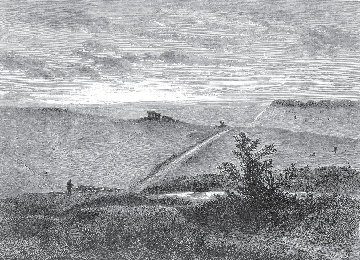
The village of Ansty is spread along a road which runs through the chalk hills of central Dorset: a well-ordered ribbon of housing where you can’t quite work out where one village stops and another begins. Ansty means ‘path for one’ or ‘narrow track’ – an appropriate place to venture out to walk one of the reputed (and disputed) great highways of prehistoric England. It is midmorning, and this walk begins like many others being undertaken on this bright June day across the country. I walk alongside my friend Liv, dodging the occasional car, from green lane to bridleway and then footpath. Fields, untidy hedgerows, tarmac and grass. We stop to greet two long-faced rams and then, turning at a farm gate, we press on straight, directly up the face of the chalk hill to the top of an escarpment.
Behind us is the verdant Blackmore Vale, the land of Tess of the d’Urbervilles, Hardy’s ‘engirdled and secluded region, for the most part untrodden as yet by tourist or landscape-painter’, where ‘the fields are never brown and the springs never dry’. Looking north we are facing the direction of some of the islands of prehistoric settlement which dot Dorset. Under two miles away is Bulbarrow Hill, the remains of an Iron Age hill fort, and five miles further still over the downland, the assertive features of Hambledon Hill.
Facing away from this vale, we look south into a valley of chalk, scooped out like the bowl of a dessert spoon. Across this amphitheatre a thin corona of cloudy summer sun tops the distant
hills, a glowing line across the horizon. We make our way along the narrow hilltop and I can see where recent walkers have made their own paths, negotiated their own ways, step by step along the steep bank. I choose the wrong route, larger steps required to overcome thick solid tussocks, although it does mean that I stumble across, and almost on, a heath spotted orchid, pink-hearted and creamy white against the dusky green grass. Moving along this escarpment, on the strip of land between two valleys, we are walking the path which for centuries was most associated with prehistoric people on foot: a ridgeway.
This route is marked out on the Ordnance Survey map as the Wessex Ridgeway, and occasionally on posts by the path with plastic waymark discs emblazoned with an upright, seriouslooking dragon/serpent hybrid (perhaps a nod to where this path begins, on the south coast near Lyme Regis, where it climbs directly up Dragons Hill). This long waymarked path is part of a much longer posited ridgeway, a sash that splits south and eastern England – from the Dorset coast to the East Anglian Wash. This longer path has been named the Greater Ridgeway (sometimes the Greater Icknield Way). Under this Greater umbrella, a meandering line has been traced on the map, a collection of modern long-distance leisure paths.6
The idea of this long prehistoric path captured the imagination of romantics, writers, poets and antiquarians of the nineteenth and early twentieth centuries. They regarded this Greater
6 This long chain of paths starts with the Wessex Ridgeway, and then connects with the Ridgeway National Trail near Avebury in Wiltshire. The Ridgeway then runs through four counties to Buckinghamshire at which point the Icknield Way takes over, ending just outside Thetford in Norfolk. The ‘Greater Ridgeway’ then makes a distinct northward turn. Here it becomes what looks like a straight line through the landscape on a path called the Peddars Way (or perhaps on an alignment roughly parallel to the Peddars Way), which reaches the North Sea.
Ridgeway as the primordial path. Travel writer H. V. Morton, when addressing the East Anglian stretch of the path, writes of it being ‘planned before history began’. A path which has seen ‘the stone weapon give way to metal’, which has ‘nursed the dawning of civilisation . . . first a savage trail, then a road’. For the Victorian writer Richard Jefferies, it was a special path for significant journeys in prehistory:
A broad green track runs for many a long, long mile across the Downs, now following the ridges, now winding past at the foot of a grassy slope, then stretching away through cornfield and fallow. It is distinct from the waggon-tracks which cross it here and there, for these are local only . . . The origin of the track goes back into the dimmest antiquity; there is evidence that it was a military road when the fierce Dane carried fire and slaughter inland, leaving his ‘nailed bark’ in the creeks of the rivers, and before that when the Saxons pushed up from the sea. The eagles of old Rome, perhaps, were borne along it, and yet earlier the chariots of the Britons may have used it – traces of all have been found; so that for fifteen centuries this track of the primitive peoples has maintained its existence through the strange changes of the times.
Many of these romantic writers pieced together this path, hundreds of miles long, from what they could see in the landscape. They plotted barrows, stone circles and henges, ascribing them a significance in relation to the Greater Ridgeway – monuments as ritual markers on the path. They saw prehistoric man (and it always was ‘man’) striding along the ridges, passing these sacred places and avoiding marsh, bog and swamp in the valleys below.7 Perhaps this man would be carrying a small collection
7 The idea of prehistoric swamps perhaps came down to these romantics from the Roman historians. Herodian writes that ‘most of the regions of Britain are
of stone axes, or some other valuable items, in his bag to trade at the furthest end of this long continuous track. To poet Edward Thomas these men were ‘early nomads’ walking from island to island of high ground on a path which ‘ran along the back of each one and branched over the spurs . . . highways of great length, like that trodden by Launcelot, “far o’er the long backs of the bushless downs” to Camelot’.
Considering this ancient track, I turn towards the trees at the end of the escarpment, where a series of terraces has been cut into the ground next to the path. These are strip lynchets (from the Old English hlinc – ‘ridges’, ‘bank’ or ‘rising ground’).8 They have been formed over many years for cultivating the ground, either deliberately created or through the action of hundreds of years of ploughing and pushing the earth down into lines which band the side of the hill. These distinctive marks help define the features they surround, exposing the shape of farmsteads, enclosures and their paths – the trackways of this small community. This chalk landscape holds indentations well, and there are further features scattered around this area which give clues to prehistoric settlement. Along the ridge is the ghost of Nettlecombe Tout, another Iron Age fort, formed with a long rampart and a ditch ten feet deep.9 The top of the next valley along is braided by a series of cross dykes which cut across the valley ridge. These Iron Age earthworks were likely to have been marshy, since they are flooded continually by the tides of the ocean’ and that ‘the barbarians are accustomed to swimming or wading through these waistdeep marsh pools’. Cassius Dio writes that the tribes of Britain ‘inhabit wild and waterless mountains and desolate and swampy plains’.
8 The same word, via Scots, leads to ‘links’ to describe a golf course.
9 The prominent fort also features briefly in Tess of the d’Urbervilles : ‘If Tess were made rich by marrying a gentleman, would she have money enough to buy a spy-glass so large that it would draw the stars as near to her as Nettlecombe Tout?’
defensive, blocking the approaches to the fort, or perhaps marking the territory of the people who inhabited this area.
And beyond, over the gently rippling chalk downland to the south-east, eight miles towards the fractal inlets of Poole Harbour, can be found the largest unenclosed pre-Roman settlement in Britain. Archaeologists have uncovered a community who lived together in the late Iron Age, in hundreds of densely packed roundhouses alongside outbuildings and animal pens. This settlement is named Duropolis after the local tribe. The Durotriges were, like most Iron Age people, farmers and probably controlled a territory which stretched from the River Axe in the west to the Avon in the east. The location of Duropolis is important in giving more complexity and nuance to the picture of prehistoric Britain than the idea of the Ridgeway implies. It is not high up at the top of the hills but set on gently sloping ground. When the Romans came, they found people spread widely across a varied landscape, not just encamped on high ground.
On the ridge above Ansty, we leave the sun, plunging into leafdarkened woodland and an extraordinary meeting of paths. Here there is a depression in the escarpment and the Wessex Ridgeway joins us again, dipping briefly with the ridge. There is a disorientating star-shaped junction of paths known as the Dorsetshire Gap. On the map, four clear rights of way come together, but spinning around from one to the other it is difficult to keep track of them. They are deep holloways, natural geological depressions greatly aided in their depth by the pounding and scraping of generations of feet and hooves. Corridors galleried with moss-creeped beech and ash wind away from the Gap, sinking out of sight. Wooded depressions in the soil that recall a line from George Eliot’s Adam Bede : ‘hollow-shaped, earthy paths . . . paths which look as if they were made by the free will of the trees and underwood, moving reverently aside’.
This is a world almost turned upside down, a place where you look up, not down, to see tree roots; where the beginnings of the undergrowth and leaf litter is ten feet above your head, and the ground slants at extraordinary angles. Climbing carefully to the top of one of the banks, taking the obvious way where someone or something has gone before, I take some photos of Liv, her figure far below, dwarfed by the immensity of the surroundings. It feels as though the sun may never reach the furthest depths of the holloways, that the leaves, if it weren’t for the free-draining chalk soil, would never fully dry. The actual walked paths are thin at the bottom of the holloways, hemmed in by just-wilting wild garlic. The V-shape of these deep paths suggests that they have been formed by the passage of single people (or perhaps small groups) or horses rather than carts or herds of animals.
We walk back and forth down the paths, always drawn back to the centre of the Dorsetshire Gap. This is a meeting point of paths, a place for continuing journeys. The settlements that have been uncovered in the neighbouring lonely valleys and beyond suggest a landscape which, at least in the Iron Age, was alive with activity, with people moving between farmstead and field and between settlements and fortifications. Rather than a point on a signature ancient highway which stretched unimpeded across southern England, the Dorsetshire Gap is part of this complex prehistoric network – local, regional, national and international.
Our understanding of this web of paths emerges more clearly with the aid of modern archaeological techniques. We no longer have to rely on mapping large impressive monuments in the landscape to piece together our prehistoric history. Through analysing the isotopes found in bone and teeth, we can see evidence that animals were driven across Britain, over significant distances, to henges in Dorset and Wiltshire, and that a man buried close to Stonehenge in the third millennium BC had journeyed from what
is now Germany. Analysing DNA has enabled us to see indications that early Neolithic farmers had genetic links with central Europe and the Iberian Peninsula. We also understand much more about the economies and societies of our prehistory. A stone axe would be unlikely to travel from Norfolk to here in Dorset on one long journey but instead made its way slowly across England, passed between people over years and sometimes generations. An object which would be used to cement relationships between a succession of neighbouring groups – exchanged from one hand to another, carried along one path to the next.
In the Dorsetshire Gap we are all alone, hidden in the trees, the only walkers seemingly for miles. But a plastic box to the side of this crossroads bears witness to others having come before. Alongside an abandoned beer bottle, a notebook has been left, a record of visits to the Dorsetshire Gap. This is one notebook in a long chain which goes back to at least the 1970s, taken away when full to be stored carefully somewhere. The recent notes record long attachment to the Gap (‘I have been coming here for forty years or so, on and off. It’s always beautiful. Always healing’) and discovery of this place (‘Londoners enjoying the air, the view, the peace and a walk with our kids’). There are touching messages in the time of Covid, intrusions of the world away from these woods: ‘Good luck and good health’, ‘stay safe’ and ‘I’m writing this with gloves on’, and a more worrying one: ‘DO NOT TAKE THE BILL GATES CHIPPED VACCINE – IT WILL BE THE MARK OF THE BEAST ’. To this last one, I can only agree with the comment left in the book by a subsequent visitor: ‘NEED ANY MORE TINFOIL ?’10
Perhaps it was the realities of modern pandemic Britain that broke the spell keeping us in the Dorsetshire Gap. Taking a
10 I received my second vaccine exactly thirty-seven days after visiting the Dorsetshire Gap, a wonderful blast of Pfizer.
bridleway south-west, if anything the path drops even more impressively into the earth, and for 800 feet or so we are walking in a hart’s-tongue-fern-lined canyon, emerging into the open air in the bottom of this scoop of land. The recorded rights of way run along and up the bulging and swirling contour lines, smooth serpentine paths. But even around the Dorsetshire Gap, paths have disappeared from the map.
The Ordnance Survey map from 1900 shows lost bridleways and footpaths on these chalk hills. One of these lost paths heads straight for the deserted medieval village of Melcombe Horsey and the manor of the same name. This land used to belong to the Binghams, who give their name to the parish, a family which married into the Turbervilles, the surname claimed, with a slight change, by Hardy for the eponymous Tess. We are now standing where the old path came down from the escarpment, where a community disappeared maybe 600 years ago. A large farmhouse with a scattering of outbuildings is all that remains, next to the neat plot of complex lumps and pitted earth. The whole abandoned village lies under a grass coat. An access road now runs from the farm out of the valley. The modern tarmac is to the right of two lines of trees which appear to mark the course of an older path. This leaves a wide high bank of grass stained with soft lines of where people have walked before, under the shade of russet copper beeches.
‘Once a highway, always a highway’; this legal maxim governs the saving of lost and forgotten paths. All public rights of way are highways – footpaths just as much as your local high street or the A1. A landowner who blocks a seemingly inconsequential stretch of footpath is obstructing the King’s Highway.11 To
11 Upon the death of Elizabeth II in 2022, the Queen’s Highway automatically became the King’s Highway, in the same way that senior lawyers went from
legally reclaim our lost paths we need to demonstrate use by the public in the past, evidence of use that can stretch back to time immemorial. However, the past has its limits. The term ‘time immemorial’ feels like it should describe something so distant in the past that we can’t quite grapple with it, something indubitably ancient. In fact, the Statute of Westminster of 1275 defined time immemorial to a precise date, 6 July 1189, when Richard the Lionheart acceded to the throne. Any evidence of use before this date is disregarded in efforts to save and reclaim lost paths.12
The path from the abandoned medieval village of Melcombe Horsey heads directly to the Dorsetshire Gap, a meeting of two prehistoric paths – part of the same network but separated by thousands of years. Continuity comes from human instinct. In one island, 80,000 miles square, people have settled in not too dissimilar places and they have needed to communicate, hunt, farm
being QC s to KC s. The King’s Highway has an interesting intersection with the mythology of the Greater Ridgeway. The Icknield Way section of the Greater Ridgeway can trace its foundational legend back to the twelfth century, when historians turned their thoughts to the history of our paths and tracks. Henry of Huntingdon, in his Historia Anglorum, writes of ‘four highways’ of England, with regal protection ‘on which no one should dare attack his enemy’. Three of these are identifiably Roman roads: Ermine Street, the Fosse Way and Watling Street, and the fourth is the mysterious ‘Ichenild’. Geoffrey of Monmouth, writing in the same decade, embellishes the legend of Icknield Way further. He assigns the creation of the ‘four highways’, as physical routes and zones of protection, to Dunwallo Molmutius, a mythical ruler who ‘excelled all the kings of Britain in valour and gracefulness of person’. The protection that these highways supposedly offered was part of an entirely mythological package of fundamental laws laid down by King Molmutius.
12 There is a certain irony that this date for claiming public rights of way was set at the beginning of the reign of a king who hardly ever rode the paths and roads of England. It is estimated that on becoming king he only spent about six months in the country.
and trade. Our oldest paths are spread across the map, in the valleys and on the ridges – paths used in prehistory folded into and under our current rights of way and road network. ‘Modern’ paths we follow for a summer stroll in Dorset may have under them strata of thousands of years of movement, reaching much further back than time immemorial.
The meadow is broad, and drifts of common bent grass give a purple-hued smudge to the horizon. We create our own path through, heading towards a ten-foot-wide woodland-flanked track. The woods are reassuringly thick – coppiced oak alongside maple, aspen, birch and hawthorn. Along with my friend Anna, I am searching for two things: the grey scaly bark and spiked leaves of the wild service tree, growing somewhere in these ancient woodlands, and a lost, almost forgotten lane. This is a small surviving patch of Bernwood Forest, in Buckinghamshire’s Vale of Aylesbury. A royal hunting ground established by the Saxon kings. In my mind this ancient forest would have extended for hundreds of miles just like this: thick, green and dense. Monumental. In reality this land was more akin to a royal reserve, with woods of varying density interspersed with open ground, the perfect environment for the royal pursuit of deer and wild boar.1 It is from Bernwood Forest that we have the earliest surviving depiction of an English village.2 It’s a map which puts hunting at its heart (older sources link the village’s name, Boarstall, to this hunting; however, more modern historians trace its derivation to the Old English for ‘the site of a stronghold’ – burh-stall). Shown are a church and a tower, some fields, a small network of roads and houses in hedge-ringed plots. To the sides are the surrounding great forest, deer walking and resting amid the trees. Several oversized figures are depicted in
1 The etymological root of ‘forest’ is foris, which just means ‘outside’.
2 The map is dated to at least 1444 but may be much older still.
the foreground. One is kneeling: Nigel the Forester of Bernewode. He is presenting the head of a fearsome boar impaled on a sword. A beast which had terrified the people of the forest. The man accepting this bloody gift: Edward the Confessor.
Bernwood Forest was Edward’s favourite hunting ground; Kings Henry II and John were also fans. This was a place reserved for them, land for the king’s use. The royal connections persist in its place names. To the west is Kingswood. There are myths and memories of a track between the trees somewhere near this hamlet, a path called Rosiman’s Waye – named after the supposed mistress of Henry II , Rosamund Clifford. It is said that Henry built a complicated maze in the park at Woodstock in Oxfordshire to hide his beautiful mistress from Queen Eleanor (who was pregnant with Henry’s seventh child when the affair is reputed to have begun in 1165), but the queen found out and managed to negotiate the twisting paths of what was known as the Bower of Fair Rosamund. She confronted her rival and forced her to choose death by dagger or a bowl of poison. Rosamund took the poison and died at the heart of Henry’s maze. The tale of Rosamund’s death is almost certainly a fantasy, a slandering of Eleanor as a callous murderer by later chroniclers. It’s a fairy-tale archetype – the jealous older queen poisoning her younger rival, set in a landscape of folk horror, shadowy woods and dark labyrinthine paths.
This part of Bernwood is today called Ham Home Wood, one of the patches of the royal forest which survives in Oxfordshire and Buckinghamshire. As important as their historical significance is, their role now as precious habitat islands – small niches which support rare hoverflies, moths, butterflies and beetles. The wood clings to the north side of Akeman Street, a Roman road linking up with Watling Street and the Fosse Way, a connection between the Roman settlements at Cirencester (Corinium Dobunnorum) and St Albans (Verulamium). Along
the eastern side of the wood, there is a narrow strip of land which runs clear of the trees and northward up Oving Hill – marked on my Ordnance Survey map as ‘Oxford Lane (Track)’. The border between wood and lane has all but disappeared, with blackthorn drifting across the boundary and grey willow suckering on both sides. I can’t get up the lane; a dense thicket of nettles and a gate now bar the way to public access. Yet hundreds of years ago this lane, passing through the venerable Bernwood, would have been thundering with the sound of hooves, my view from this roadside obscured in a swirl of dust. The Oxford Lane was once a local drove road, intended for transporting animals, one of hundreds of similar paths that connected pasture and field to village, town and city.
I’ve been led here by Bruce Smith, who has been ‘collecting’ (and walking) drove roads across England and Wales since 2005. Bruce has traced sections of the Oxford Lane cutting across Northamptonshire, Oxfordshire and Buckinghamshire – some now major and minor roads, others recorded public rights of way and others simply lost. Turning from the gate, we venture towards Wotton Underwood village to see if we can find any continuation of the Oxford Lane south of Akeman Street.3 It’s a hunt in the landscape for part of this old path, to walk in the footsteps and hoof prints which have come before. The area is crossed by recorded public rights of way, patterns of movement from the last few centuries which have stood, captured in time, on the map and on the ground. We walk on a concrete path through the centre of the community, the fluffy seeds from a row of poplar trees turning the path from grey to white. A small smattering of houses and a church collect around the grand
3 The ‘Underwood’ is a further sign of the parish’s relationship with Bernwood. Previous names for this community include ‘Wotton juxta Bernewode’ and ‘Wotton subtus Bernewode’.
Wotton House, a solid rectangular manor. This doesn’t have the feel of a typical English village; the homes are huddled together but isolated from the rest of the world at the centre of this grand estate, in their own secluded bubble. Along this path once stood a row of cottages and smallholdings. In the early eighteenth century, the lord of three local manors, Richard Grenville, built the first Wotton House, overseeing hundreds of farmers on his sprawling lands. Three decades later, his son of the same name was elected to Parliament and obtained an Act to enclose the land. Some 1,668 acres of ‘common fields, Lawns, Wastes and uninclosed [sic] Grounds’, along with many of the residents, were swept away.
People’s homes and livelihoods were replaced with a new, fashionable ‘natural’ landscape, in this instance a wide avenue, grotto and lake designed by the most in-demand landscaper of the time, Lancelot ‘Capability’ Brown. A later owner of the Wotton Estate, the third Duke of Buckingham and Chandos, revived the village somewhat by building a school and a post office.4 He also used the estate to indulge his passion for railways, building several lines across it (one of these lines, the Brill Tramway, would become part of the London Underground for two years in the 1930s before it closed for good). On our walk we stumble across a narrow-gauge track, part of the Wotton Light Railway – a private line owned and operated by a high court judge as a hobby.
Given so many centuries of change, it is no wonder we can’t find a trace of the Oxford Lane. Perhaps it did run here before
4 The school was closed in 1968 after a further period of decline for the village. A plaque in the church bitterly describes the change: ‘This school and its predecessor served Wotton children from 1790 until 1968. After 1948, when the estate was sold, the character of the village entirely changed. Most of the villagers were unwillingly turned out of it, and the number of scholars diminished until the school could no longer continue.’
the land was enclosed, or maybe it linked into the network at Akeman Street. The lane’s ultimate destination, thirteen miles to the south-west, was Oxford, a city whose fortunes had, by the seventeenth century, become intertwined with the university. Indeed, it is likely that the final destination for the animals was to be the tables of Oxford college dining halls.5 But first, they had to go to the city’s slaughterhouses. Originally the killing and butchery would have happened right on the street, specifically the prime pedestrianized shopping avenue of Oxford – Queen Street (then, unsurprisingly, known as Butcher’s Row). By the fourteenth century, the butchers had been relocated away from the city centre streets. First to the shambles just outside the city walls, where they slung the ‘entrails of Beasts’ into a nearby stream (an act described as an ‘extreme negligence’), and then to Oxford’s new covered market.6
We are hidden away from the gory slaughter of the animals we eat and also from how they are transported to our plates. In an age when our food arrives by lorry, plane and delivery van, it is difficult to imagine the sheer number of animals that were being moved on the ground in past centuries and the impact they had on the everyday rural landscape. Drovers’ roads are most associated with great herds of cows but they also carried sheep for their wool (and meat), and geese and turkeys, with their feet protectively dipped in tar and covered in sand – driven to London from August onwards in time for the Christmas dinner table. Pigs struggled up the paths, barely managing to walk ten miles a day, and donkeys were ferried over from Ireland to join
5 Perhaps they were served alongside the turbot in lobster sauce, veal pie and fruit fool at the legendary banquet given for the Duke of Portland at Christ Church College in 1793.
6 ‘Shambles’ is an archaic name for a slaughterhouse, a word preserved in the name of a famously picturesque street in York. The Shambles of York, like Queen Street in Oxford, no longer has any butcher shops.
the menagerie.7 Sometimes drovers rode on horseback (the cowboys of Britain) and they usually travelled with dogs to keep the animals in check. Welsh drovers favoured corgis, a breed chosen for their comical closeness to the ground, which meant they could avoid the kick of a bullock. There are even tales of drovers travelling home by coach and letting their dogs find their own way back across the country, where, along the way, they would be fed and watered in the drovers’ inns. One dog, Carlo, was recorded as being sent back to Wales with a pony’s harness on its back, his owner having sold the pony, and a note for innkeepers asking for him to be looked after on the way. The skills of the drover’s dog are evident in an incident relayed by Delabere P. Blaine in his Encyclopaedia of Rural Sports, which saw a dog drive a pack of sheep and oxen nine miles to market in Alston in Cumbria – completely unaccompanied.
The number of animals involved is staggering – almost 19,000 cows alone passed through Carlisle in 1663; Daniel Defoe recorded 150,000 turkeys travelling from Norfolk to London in 1724; and a single tollbooth in Wiltshire registered payment for over 14,000 pigs in 1830. These great forced migrations would have been unmissable in the open countryside. In Far from the Madding Crowd, Thomas Hardy describes the experience of sheep converging on a fair: ‘When the autumn sun slanted over Greenhill this morning and lighted the dewy flat upon its crest, nebulous clouds of dust were to be seen floating between the pairs of hedges which streaked the wide prospect around in all directions.’ To add to the visual spectacle would be the noise: the cries of the beasts, the barking of dogs and the cracking of 7 Another animal which perhaps used the Oxford Lane was the famous Aylesbury duck, flocks of which were driven the forty miles to London from their homeland in the Vale of Aylesbury.
whips.8 The sound of the drovers themselves was described in one account as ‘something out of the common, neither shouting, calling, crying, singing, hallowing or anything else, but a noise of itself . . . made to carry and capable of arresting the countryside’.
Now, in slightly quieter times, I am exploring the suburbs of Daventry in Northamptonshire. Five thousand years ago, the Scots pine was driven out of England by a warming climate and retreated to its native Scotland as well as more remote parts of Wales (as John Evelyn wrote in Sylva, his 1664 treatise on forestry, ‘the worst land in Wales bears (as I am told) large pines’). Standing in front of a nursing home in Daventry, I’m looking up at two Scots pines which appear to be well over 200 years old. With their tall evergreen canopies rising high above the more common deciduous trees, these pines are an indication that there was once an inn for drovers here, the Wheatsheaf. The cones of these trees may have been carried in the pockets of the drovers on journeys from Wales or Scotland. Pines were planted as welcome waymarkers, letting fellow drovers know they could stop for the night (or planted to signal good pasture and safe river crossings). Inside an inn such as this, drovers could expect to find a comforting fire, a hot meal (on one drove road leading to a fair, the inn had ‘vast stores of provisions, notably gigantic pies with standing walls of crust of preternatural toughness and thickness’) and ale (the financial accounts of a drover in 1841 record a pint costing 3p). After a meal and drink, the head drover would retire to bed, but the lowlier members of the droving party would often not stay inside, banished to spend the night in a nearby barn or huddled up under a hedge.
8 While whips were used on large animals, such as cattle and donkeys, sticks would have been used to ‘persuade’ sheep along. The 1890 census lists quite a few ‘ankle beaters’, the men who wielded the sticks.