Roanoke County | Comprehensive Safety Action Plan
Prepared by Timmons Group
February 2025

Safe Streets and Roads for All


Prepared by Timmons Group
February 2025
A special thank you to all our partners who contributed to this Comprehensive Safety Action Plan:
Roanoke County
Philip Thompson, Director of Planning
Megan Cronise, Assistant Director of Planning
Isaac Henry, Principal Planner
Nathan Grim, Transportation Planner
The Town of Vinton
Botetourt County
Timmons Group
Thomas Ruff
Lauren Delmare
Zachary Holder
Rachel Moon
Emily Routman
Between 2015 and 2023, there were 47 fatal non-interstate traffic crashes in Roanoke County. In the same nine-year time-frame, there were 494 serious injury crashes on our transportation network. That represents an average of five fatal and 55 serious injury crashes each year. These severe crashes are preventable tragedies that can be reduced or eliminated through innovative design, strategic policies, and committed local leadership.
This Comprehensive Safety Action Plan is part of Roanoke County’s commitment to enhancing roadway safety under the Federal Safe Streets and Roads for All (SS4A) program. The plan outlines targeted strategies to improve road safety, reduce crashes, and promote a culture of responsible driving. Fatal and serious injury (FSI) crashes are analyzed due to their severity. Fatal crashes result in one or more deaths and serious injury crashes involve incapacitating injuries, beyond visible injuries such as bruising, abrasions, swelling, or limping; serious injury crashes may be life-altering. By implementing engineering solutions, enhancing enforcement measures, and fostering community education, Roanoke County can create a safer, more reliable roadway system for all.
In 2022, the US Department of Transportation (USDOT) awarded $280,000 to Roanoke County, Botetourt County, and the Town of Vinton. With a $70,000 match from the localities, these funds were used to develop a comprehensive safety action plan as part of the Safe Streets and Roads for All (SS4A) Grant Program. The SS4A program funds regional, local, and Tribal initiatives throughout the country through grants to prevent roadway deaths and serious injuries. The program focuses on the development of a comprehensive safety action plan and its implementation for all users of a jurisdiction’s highways, streets, and roadways, including motorists, bicyclists, pedestrians, and more.
According to USDOT, an Action Plan is required to have the following aspects:
1. Leadership and goal setting: A high-ranking official and/or governing body in the jurisdiction publicly committed to an eventual goal of zero roadway fatalities and serious

“The greatest benefit of the Safe Streets and Roads For All Comprehensive Safety Action Plan has been highlighting the roadway intersections and corridors where our worst crashes are occurring. With additional insight into why the crashes are taking place, we can now focus on leveraging our limited County resources to improve safety and save lives in these high crash areas.”
-Richard Caywood, County Administrator
Our goal is to reduce roadway fatalities and serious injuries by 50 percent by the year 2045.
The Roanoke County Planning Department led the SS4A Action Plan process and development, in close partnership with the Town of Vinton and Botetourt County. The creation of this action plan could not have been possible without the guidance and collaboration provided by stakeholders including elected officials, the Planning Commission, Police, Fire and EMS, Engineering and Public Works staff, Public Schools staff, the Roanoke Valley-Alleghany Regional Commission (RVARC), and the Virginia Department of Transportation (VDOT).
SMART SCALE Funded Diverging Diamond Interchange Project
See page 114 for more details
The Safe System approach, developed and adopted by the USDOT, is a framework that guides safety efforts. It works by building and reinforcing multiple layers of protection to both prevent crashes from happening in the first place and minimize the harm caused to those involved when crashes do occur. It is a holistic and comprehensive approach that provides a guiding framework to make places safer for people.
This is a shift from a conventional safety approach because it focuses on both human mistakes AND human vulnerability and designs a system with many redundancies in place to protect everyone.
The Safe System Approach is arranged around five complementary objectives: safe road users, safe roads, safe vehicles, safe speeds, and post-crash care. Together, these objectives help steer safety programs to a future with reduced roadway fatalities and serious injuries in Roanoke County, Botetourt County, and the Town of Vinton.
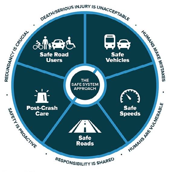
Safe System Approach. Source: FHWA
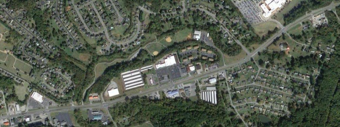
The safety analysis is informed by a historical crash analysis within Roanoke County. Historical crash data, from January 1, 2015, to December 31, 2023, was reviewed to evaluate patterns and trends within the crash data such as crash types, crash locations, and contributing circumstances. Crashes on interstates I-81 and I-581 were excluded from the analysis in order to focus improvements on roads where Roanoke County is most able to affect change; interstates fall wholly under Virginia Department of Transportation (VDOT) purview. Crashes within the City of Roanoke, the City of Salem, and the Town of Vinton were also removed from the dataset. The scope of this Safety Action Plan is non-interstate crashes located within Roanoke County.
This analysis focused primarily on the 541 non-interstate severe crashes in the nine-year time period that resulted in fatal and serious injuries. Within Roanoke County, there were 47 fatal crashes and 494 serious injury (FSI) crashes reported during the study period.
Figure 1 illustrates the non-interstate severe (fatal and serious) crashes reported by year within the county. Though some variation occurred year-to-year, the number of fatal and serious crashes in the county remained relatively steady.
Figure 1. Severe Crashes by Year, Roanoke County (2015-2023)
Roanoke County
47
severe crashes resulting in fatality
494
severe crashes resulting in serious injury
60.1
average annual severe crashes
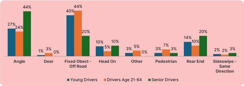
The most common crash type among the fatal and serious injury (FSI) crashes reported in the nine-year analysis period was fixed object off-road crashes, which accounted for approximately 37 percent (37%) of all fatal and serious injury crashes in Roanoke County. Angle crashes (28%), rear-end crashes (13%), and headon crashes (7%) were the next most common crash types reported. Figure 2 summarizes the fatal and serious injury (FSI) crashes reported during the nine-year analysis period by crash type.
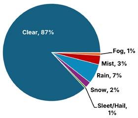
The vast majority of severe fixed object off-road crashes occurred during clear weather conditions (87%), and most commonly occurred during the day.
Fatal and Serious Injury Crashes Only Roanoke County (2015-2023)
The environmental factors contributing to crashes can highlight potential areas for improvement in the roadway network to better serve the traveling public. Factors such as lighting and weather were analyzed for the 541 crashes reported in Roanoke County.
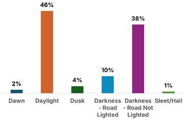
Figure 5 illustrates the impact of changing lighting conditions on roadway safety. When fatal and serious injury (FSI) crashes occur at night, they are significantly more likely to occur when the road is not lit, compared to when it is lighted.
Overall the environmental factors contributing to crashes were consistent with statewide trends. 31% of Roanoke County’s severe crashes occurred at night compared to 38% in all of Virginia, 9% of Roanoke County’s severe crash occurred during rain compared to 10% in all of Virginia, and 14% occurred during wet roadway surface conditions compared to 14% statewide.
9% of severe crashes occurred during rain
31% of severe crashes happened at night
14% of severe crashes happened during wet surface conditions Figure 5. Crash Types by Lighting Conditions, Roanoke County (2015-2023)
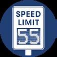
Higher driving speeds lead to higher collision speeds. Higher driving speeds also make crashes more difficult to avoid because high speeds provide less time to process information and to act on it, and require longer break distance. 56% of fatal and serious injury crashes occurred on roads with speed limits of 45 mph or higher. High speeds are especially dangerous for road users outside of a vehicle. According to the FHWA, pedestrians have a 90% chance of surviving a crash involving a vehicle traveling 20 mph or below, and less than a 50% chance of surviving a crash with a vehicle traveling 30 mph or above
Exceeding the posted speed limit further heightens the risk of a severe crash. In Roanoke County, 29% of fatal and serious injury crashes involved speeding, similar to the 32% of crashes statewide.
According to the National Highway Traffic Safety Administration (NHTSA), every day, about 37 people in the United States die in drunk-driving crashes. In 2022, 13,524 people died in alcohol-impaired driving traffic collisions.
Drivers with a Blood Alcohol Concentration (BAC) .08 (the legal limit) are approximately 4 times more likely to crash than drivers with a BAC of zero. At a BAC of .15, drivers are at least 12 times more likely to crash than drivers with a BAC of zero.
In Roanoke County, 24% of fatal and serious injury crashes involved drugs or alcohol, compared to only 17% statewide.
Distracted driving is defined as any activity that diverts attention from driving. According to the NHTSA, in 2022, 3,308 people died in traffic collisions that involved distracted drivers. Such distractions may include talking or texting on the phone, eating or drinking, or adjusting the audio navigation system. Sending or reading a text takes a driver’s eyes off the road for 5 seconds. At 55 mph, that is equivalent to driving the length of an entire football field.
In Roanoke County, 17% of fatal and serious injury crashes involved distracted driving, compared to 19% statewide. Note that distracted driving is often underreported and the actual number may be higher.
One of the safest and simplest choices drivers and passengers can make is to buckle up. Research on passenger cars has shown that seatbelts reduce the risk of fatal injury to front-seat occupants by 45 percent and the risk of injury by 50 percent. However, according to the NHTSA 2022 report on seat belt use, Virginia has the lowest use rate of any state in the U.S. at 75.6%.
In Roanoke County, severe crashes are twice as likely to be fatal if the occupants are not buckled up. 18% of serious injury crashes involved unbelted occupants, but in 40% of fatal crashes the occupants were not wearing seatbelts
29% of cars in severe crashes were speeding
24% of severe crashes involved drugs or alcohol
17% of severe crashes involved distracted driving
40% of fatal crashes involved not wearing a seatbelt
Crashes involving seniors (age 65+) and young drivers (ages 15-20) were analyzed due to the unique challenges and risk factors associated with each group.
Drivers aged 65 and older were involved in 21% of all severe crashes in Roanoke County. Residents that are 65 years or older make up 22% of the County population (2022 American Community Survey 5-year Estimates). Of all crashes on Principal Arterials, seniors were involved in one-third of crashes. Principal arterials are major highways intended to serve large amounts of traffic traveling relatively long distances at higher speeds. The most common collision type for senior drivers was angle crashes (42%).
Drivers aged 15 to 20 were involved in 20% of all severe crashes. Residents that are 15 to 20 years of age make up 6% of the County population (2022 American Community Survey 5-year Estimates). Young drivers were 50% more likely to be in a severe crash when speeding was a factor. The most common collision type for young drivers was with a fixed object off the road (35%)
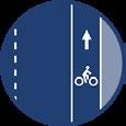
Although motorcyclists, bicyclists and pedestrians represent a small minority of overall road users, they are overrepresented in fatal and serious crashes. The figure below illustrates the relative risk of a crash resulting in serious or fatal injury for different roadway users. Less than 6% of car crashes cause severe harm, but 43% of motorcycle crashes and 46% of bicycle or pedestrian crashes result in a serious or fatal injury. Motorcyclists are 12 times more likely to be killed in a crash compared to motorists, and pedestrians and bicyclists are 18 times more likely to be killed in a crash compared to motorists.
Crash Severity of Motorists
Crash Severity of Motorcyclists
Crash Severity of Bicyclists & Pedestrians
Among the 541 fatal and serious injury (FSI) crashes, there were 25 pedestrian crashes and three bicycle crashes recorded within Roanoke County during the nine-year analysis period. Among these incidents, five of the pedestrian crashes resulted in a fatality; all three of the bicycle crashes resulted in serious injury.
A majority of the pedestrian crashes (56%), occurred during the night time under dark conditions. Eight of the bicycle and pedestrian crashes (32%) involved drugs or alcohol. Almost half of the pedestrian crashes (44%) occurred on 45 mph roads. Most of the bicycle and pedestrian crashes occurred where bicycle or pedestrian facilities are not present.
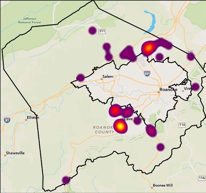
Figure 7 shows these crashes throughout the region. Hotspot locations include Brambleton Avenue in the vicinity of Cave Spring Middle and Elementary School, Peters Creek Road in the vicinity of Burlington Elementary School, and Williamson Road. 25 pedestrians killed or injured in crashes
3 bicyclists injured in crashes
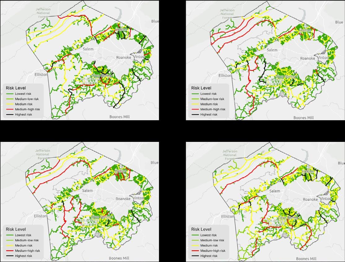
In addition to understanding historical trends, it is important to locate the places where people are most likely to be injured in a crash. This effort utilized the ESRI Traffic Crash Analysis Solution to better understand and map out the areas with the highest incidence of serious injury and fatal crashes – along with crashes of other severity types.
The Traffic Crash Analysis solution provides a range of capabilities designed to analyze crash data using methodologies outlined by the United States Road Assessment Program (usRAP) and the Federal Highway Administration (FHWA). usRAP uses a risk-mapping protocol to create maps that show variations in the level of crash risk across a road network. These maps can guide the prioritization of highway infrastructure improvements and targeted enforcement strategies. The tool creates roadway segments, assigns crashes to the segments, and creates risk maps.
For Roanoke County, the usRAP Analysis was used to generate the following maps:
1. Crash Density: Crashes per mile of road. Emphasizes road segments that are associated with the highest rate of severe crashes. These segments represent areas where there may be the greatest opportunity to reduce crashes.
2. Crash Rate: Crashes per 100 million vehicle miles of travel. Illustrates the risk to an individual motorist while traveling through a given road segment.
3. Crash Rate Ratio: Risk expressed as the ratio of the crash rate for a particular analysis segment to the average crash rate for all segments of the same roadway type. Emphasizes segments that have above average crash rates for their roadway type.
4. Potential Crash Savings: Estimate of the number of crashes per mile that would be reduced if the crash rate for the road segment could be reduced to the average crash rate for similar road segments.
Each map includes five color coded risk levels. The risk categories include Highest Risk (top 5 percent of system), Medium-High Risk (10 percent of system), Medium Risk (20 percent of system), Medium-Low Risk (25 percent of system), and Lowest Risk (bottom 40 percent of system). Click on each map to launch a detailed map viewer in a new browser.
Note that only corridors with 3 crashes or more in the 9-year study period were placed in the two highest risk categories.
The crash risk data from the four maps generated by the usRAP analysis was combined to assign each roadway a single risk score. The result is a High-Injury Network ranking every roadway in Roanoke County.
The High-Injury Network (HIN) is a collection of streets and roadways where a disproportionate number of severe car crashes, resulting in fatalities or serious injuries, occur. While increasing safety is important on every street, identifying a HIN assists local leaders in focusing their efforts on improvements on areas that will have the greatest impact and save the most lives.
The HIN in Figure 9 shows areas where the risk score is the highest and most in need of transportation investment in red, lower scoring areas are shown in orange, and places with lowest risk score are shown in yellow.
The corridors scoring in the highest 10% of Roanoke County’s entire roadway network are highlighted and shown in a bold red. The corridors account for almost 60% of all fatal and serious crashes in Roanoke County. A few notable findings about these corridors are summarized below:
• 40% are in rural areas
• 50% are along 40-45 mph roadways
• The two most common crash types are:
• Fixed Object Off Road: 31%
• Angle Crash: 30%
Roanoke County Roadways
10% of County roads experience FSI crashes (shown in bold red in Figure 9)
Fatal & Serious Injury Crashes
59% of FSI crashes have occurred on only 10% of County roads (non-interstate roadways)
41% of FSI crashes on other County roads (non-interstate roadways)
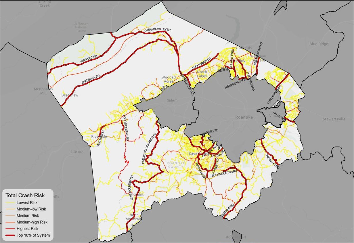
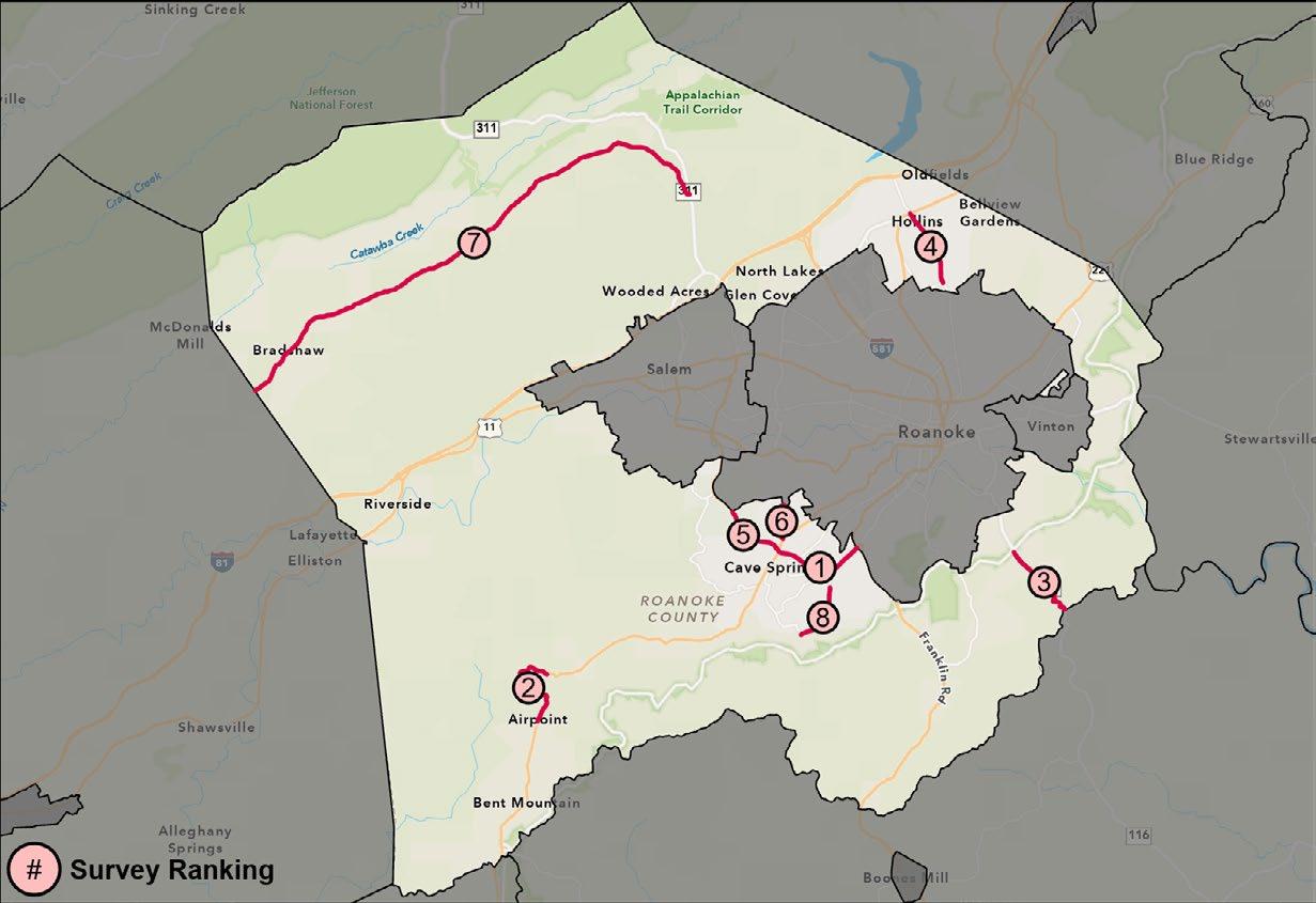
Figure 10. Priority Corridors
Map Labels A

The overall high injury network was further refined to include only the top 10 corridors. These 10 corridors represent less than 30 miles of roadway, approximately 7% of Roanoke’s non-interstate roadways, but account for 30% of all severe crashes in Roanoke County.
Refining the High Injury Network to the top 10 priority corridors ensures that Roanoke County can focus its limited resources on the areas with the greatest potential for reducing severe crashes. This approach not only enhances road safety but also improves the quality of life for all road users. By using data-driven strategies, community input, and proven safety measures, Roanoke County can make measurable progress toward the goal of zero fatalities.
These ten corridors established a preliminary list that was reviewed by elected officials, locality staff, and the public to ensure the selection aligned with broader safety and mobility goals.
Figure 10 shows the locations of the 10 highest crash corridors. Table 1 lists each corridor’s road name(s) and number of crashes.
30% of severe crashes in Roanoke County between 2015-2023 occurred on the Top 10 Priority Corridors
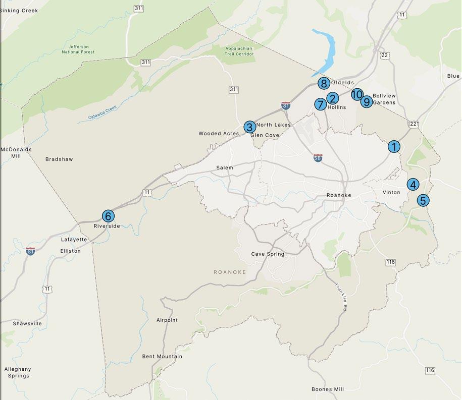
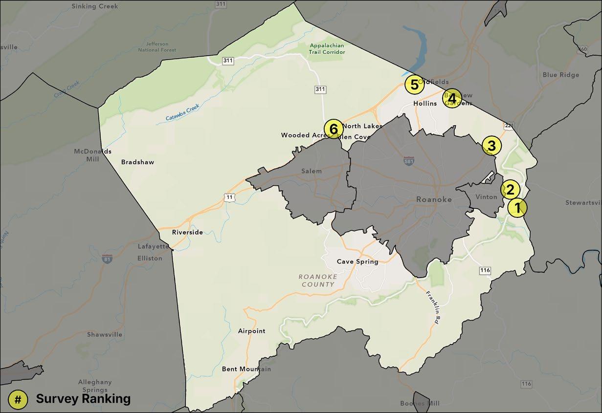
11. Roanoke County Priority Intersections Map Labels A
Fatality occurred in 2024
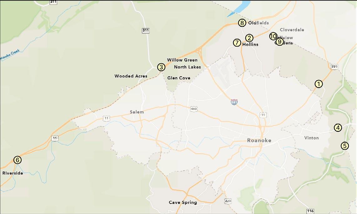
In addition to the systemic corridor analysis preformed for all Roanoke County roadways, individual intersections were analyzed to find hot spots. All intersections with fatal and serious injury crashes within 250 feet of the intersection were compiled and ranked by the number of crashes. The 10 intersections with the most severe crashes were selected for further review.
Figure 11 shows the location of the 10 highest crash intersections.
Table 2 lists each intersection’s road names and number of crashes.
Community engagement and feedback played a critical role in ensuring the development of this Action Plan was done using an inclusive and representative process. Community engagement for the initiative included holding community meetings, gathering survey responses, and distributing project information through local news campaigns, social media marketing, and online resources (such as StoryMaps and interactive dashboards). The project team also routinely collaborated with an identified stakeholder group, that consisted of representatives from the Virginia Department of Transportation (VDOT), local police, fire, and emergency response, the Town of Vinton, Roanoke County Public Schools, and other Roanoke County departments.
The first round of community meetings took place in April/May 2024. The April/May community meetings were an opportunity to introduce the project and its goals to County residents, as well as gather feedback on the identified fatal and serious injury crash locations. With feedback from the community, the project team moved forward in developing both location-specific and systemic recommendations. The September meetings presented these findings to the community and collected their thoughts and comments (see page 38 for Fall 2024 community responses).
Following each of the meetings, community members could share their on-road observations and experiences, as well as their comments on the recommendations by attending the in-person meetings or completing a paper or online survey.
The meetings were held in a variety of different locations across Roanoke County to ensure more people had an opportunity to contribute to the plan and to better target those less likely to attend meetings.
1,000 total community members reached* Over Spring 2024 Meetings Fall 2024 Meetings
235 survey responses recorded
33 total attendees at in-person meetings
• Monday, April 29th from 5-7 pm: Roanoke County (South) at the Brambleton Center Gymnasium
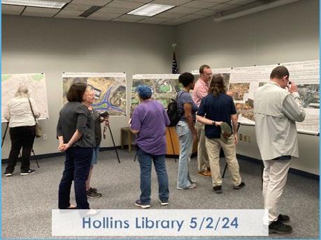
• Thursday, May 2nd from 5-7 pm: Roanoke County (North) at the Hollins Library
• Thursday, September 5th: Roanoke County (North) at the Hollins Library
• Monday, September 9th: Roanoke County (South) at the South County Library
* Includes Roanoke County, Botetourt County, and Town of Vinton Spring and Fall survey respondents and meeting attendees, observation app respondents, AGOL Dashboard views, and AGOL StoryMap views
Public outreach and participation have added a much-needed component to the evaluation and decision-making process for this project. Residents provide invaluable first-hand experiences with transportation safety issues.
To ensure that Roanoke County staff and the project team had the benefit of the public knowledge and support, a website and survey were presented to local residents to understand where they believe targeted transportation investment is needed most. The website was available for public access and comment from April 25 to May 25, 2024. Roanoke County staff worked to initiate outreach efforts on social media and other resources to share the website and survey links.
There were a total of 121 responses to the on-line survey as part of the public outreach. The survey asked respondents to rank the priority locations in order of their level of concern, and provided an opportunity to comment on the location.
Please Rate the Top Crash Intersections: (by level of concern)
AVERAGE SCORE:
Challenger Avenue & Valley Gateway Boulevard
Williamson Road & Plantation Road
Electric Road & I-81 Southbound Ramps at Exit 141
Washington Avenue & Food Lion Access (East Vinton Plaza Shopping Center)
Hardy Road & Feather Road
West Main Street & Dow Hollow Road
Peters Creek Road & Barrens Road
Plantation Road & McDonald's/Days Inn Access
Shadwell Drive & Sanderson Drive
Shadwell Drive & Hollins Road
AVERAGE SCORE:
Challenger Avenue Roanoke City Line to Botetourt County Line
Electric Road East
Brambleton Avenue to Roanoke City Line
Electric Road West
Brambleton Avenue to Glen Heather Drive
Plantation Road
Williamson Road to Roanoke City Line
West Main Street
West River Road to Pleasant Run Drive
Starkey Road
Benois Road to Merriman Road
Garst Mill Road
Brambleton Avenue to Roanoke City Line
Bent Mountain Road
Tinsley Lane to Back Creek Orchard Road
Jae Valley Road
Blue Ridge Parkway to Franklin County Line
Bradshaw Road
Catawba Valley Drive to Montgomery County Line
Please Rate the Top Crash Corridors: (by level of concern)
The responses from the community survey can be grouped into several categories based on the concerns and suggestions provided by the respondents. Below is a detailed summary of each category:
Many respondents expressed concerns about the lack of pedestrian and bicycle infrastructure in the county. Key points include:
• Need for more sidewalks and bike lanes on a variety of roads. Specific roads mentioned include Brambleton Avenue, Electric Road, Garst Mill Road, Stoneybrook Road, Feather Road, Hardy Road, Plantation Road, Washington Avenue, Williamson Road, Hershberger Road and Blacksburg Road
• Importance of prioritizing pedestrian access to commercial and community services
• Desire for improved pedestrian crossings near public facilities, such as Burlington Elementary and the Roanoke County Hollins Library on Peters Creek Road. Improvements could include installing high-visibility crosswalks or rectangular rapid flashing beacons
• Concerns about the safety of cyclists on roads with rural character such as Route 311, Twelve O’ Clock Knob Road, Carvins Cove Road, and Roselawn Road
Respondents identified several intersections of concern:
• Colonial Avenue and Electric Road near North Cross School: Speeding concerns
• Electric Road between Chaparral Drive and Colonial Avenue: Speeding concerns; Access concerns to/from Promenade Park and Electric Road
• West Main Street and Dow Hollow Road: Speeding concerns; Driver behavior concerns
• Challenger Avenue and W. Ruritan Road: Flashing yellow left turn light concerns
• Peters Creek Road and Barrens Road: Pedestrian access concerns, specifically connections to the school and library
A few respondents touched on broader issues related to public transportation and land use:
• Limit further development along congested corridors like Route 460, as existing infrastructure cannot handle increased traffic
• Improve public transportation options to reduce reliance on personal vehicles
Some respondents provided suggestions for road design improvements, both system-wide and for specific locations:
• Washington Avenue in Vinton: Convert four-lane road to two lanes with a tree-lined median to reduce congestion
• Ramp from Route 419 onto US-220 North: Reconfigure to eliminate the need for merging traffic to shift left
• Implement more traffic circles and traffic calming measures to reduce speeds on residential streets
• Improve street repairs as respondents feel that degraded streets contribute to accidents
Many respondents attributed safety issues to driver behavior rather than road design. Suggestions include increased enforcement and education measures.
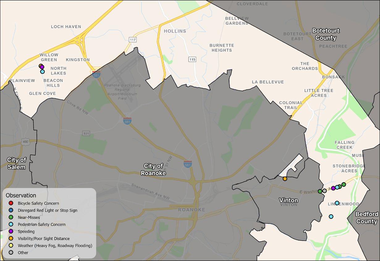
In addition to the public survey questions, participants were also provided with the opportunity to share their experiences by marking locations on a map where they had encountered specific transportation safety concerns. The observations clustered around two areas, summarized below.
Most observations clustered along Washington Avenue from the Town of Vinton to Spring Grove Drive, near the East Vinton Plaza Shopping Center. Respondents reported instances of near-misses, speeding, and the need for pedestrian infrastructure.
In addition, respondents expressed a desire for more sidewalks on the routes that connect to the corridor, such as Feather Road.
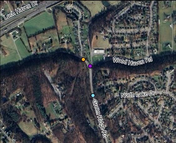
The second grouping of observations clustered around the intersection of Green Ridge Road and Wood Haven Road. Respondents reported issues with speeding and poor sight distance. These concerns, coupled with the lack of pedestrian facilities, have raised concerns about pedestrian safety.
Following the first round of community meetings, the locations of the highest fatal and serious injury crashes were finalized to study further. Locations that currently have an existing process to pursue funding or design were removed from analysis. Project exhibits for the areas already being addressed by the County are viewable in the appendix at the end of this document. The remaining locations were

Following the first round of community meetings, the locations of the highest fatal and serious injury crashes were finalized to study further. Locations that currently have an existing process to pursue funding or design were removed from analysis. Project exhibits for the areas already being addressed by the County are viewable in the appendix at the end of this document. The remaining locations were examined to determine why crashes were occurring and what kinds of crashes were taking place.
A key outcome of the Comprehensive Safety Action Plan is a set of projects and strategies to address specific safety needs that can be implemented to reduce the frequency of fatalities and serious injuries. This section of the Plan highlights proven safety countermeasures and develops potential priority projects from the High Injury Network (HIN) that can positively impact roadway safety. The Safe System Approach encourages designing transportation systems with a multi-layered safety net. If one countermeasure fails, another will help prevent a crash or, in the event of a crash, reduce the likelihood of serious injury or death. The safety net utilizes proven countermeasures designed to protect all road users.
Addressing safety in Roanoke County will require the deployment of proven safety countermeasures across the transportation network, starting with the HIN. To assist communities in taking action, the Federal Highway Administration (FHWA) designed the Proven Safety Countermeasures initiative (PCSi). The PCSi is a toolbox of 28 treatments and strategies that have been proven to reduce roadway fatalities and serious injuries nationwide. Each countermeasure addresses at least one safety focus area – speed management, intersections, roadway departures, or pedestrians/bicyclists – while others are crosscutting strategies that address multiple safety focus areas. Implementing these proven safety countermeasures
within Roanoke County’s top locations for fatal and serious injury crashes can work towards reducing crash incidents as well as crash severity. The Virginia Department of Transportation (VDOT) owns and maintains public roads in Roanoke County, therefore County staff will collaborate with VDOT on selecting and implementing any of these countermeasures.
The FHWA’s Proven Safety Countermeasures are listed below along with hyperlinks to provide a more detailed description of the effectiveness of the full safety countermeasure. The countermeasures represent a menu of possible safety improvements, and not all measures may be recommended for implementation.
Bicycle Lanes
Crosswalk Visibility Enhancements
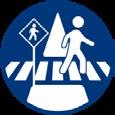
Medians and Pedestrian Refuge Islands

Road Diets (Roadway Reconfiguration)

Pedestrian Hybrid Beacons
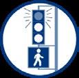
Leading Pedestrian Interval
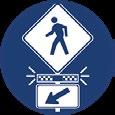
Rectangular Rapid Flashing Beacons

Sidewalks
Roadway Departure
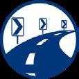
Enhanced Delineation for Horizontal Curves
Roadside Design Improvements at Curves


Longitudinal Rumble Strips and Stripes on Two-Lane Roads

Median Barriers

Wider Edge Lines

Backplates with Retroreflective Borders

Reduced LeftTurn Conflict Intersections

Yellow Change Intervals

Corridor Access Management

Roundabouts

Dedicated Left- and Right-Turn Lanes
Systemic Application of Multiple Low-Cost Countermeasures at Stop-Controlled Intersections
Crosscutting
Lighting

Local Road Safety Plans

Pavement Friction Management
Road Safety Audit
THIS PAGE IS INTENTIONALLY BLANK
In September 2024, public outreach was directed towards collecting comments on the location-specific and systemic recommendations for the intersections and corridors with the highest number of fatal and serious injury crashes.
An online survey was available from September 3 to September 30, 2024. There were a total of 114 responses as part of the public outreach. Respondents were asked how much they would be willing to spend to improve each of the priority locations, and were then asked to rank and comment on a set of potential improvements for each priority location.
The table below shows the spending prioritization for each corridor in order of their average score. The mapped ranking is shown in Figure 16.
A detailed summary of the responses to each corridor is provided on the following pages.
How would you rank the proposed improvements?
How would you rank the proposed improvements?
Conduct a multimodal corridor study Conduct
Free responses included support for more bicycle and pedestrian infrastructure along this corridor and suggested a deeper analysis on the crash patterns along this corridor. Respondents also suggested traffic calming measures to slow down traffic.
Free responses describe that as a high-volume commercial corridor, attention should be focused in this area to improve traffic flow and access to businesses while discouraging undesirable or illegal driving behavior. The intersection of Electric Road and Colonial Avenue is noted as an area of interest among respondents that warrants a focused study.
$
IF YOU WERE IN CHARGE, HOW MUCH MONEY WOULD YOU BE WILLING TO SPEND TO IMPROVE THIS INTERSECTION?
IF YOU WERE IN CHARGE, HOW MUCH MONEY WOULD YOU BE WILLING TO SPEND TO IMPROVE THIS INTERSECTION?
Conduct a corridor study or a road safety audit for Electric Road (from Bower Road to Brambleton Avenue) Consider installing centerline or
Evaluate Restricted Crossing U-Turn (RCUT) improvements at select intersections
Evaluate
Free responses echoed concerns about specific intersections and access along the Electric Road corridor. Some commented about the curvature of the roadway and challenging sight distance contributing to the difficulty of these intersections.
Free responses and community meeting attendees expressed support for the rumble strips; however, both in-person and online feedback indicates that shoulder rumble strips prohibits bicyclists from utilizing the shoulder and noise generated by centerline rumble strips startles cyclists and prevents drivers from crossing them. Shoulder and centerline rumble strips are most effective in areas with significant roadway departure crashes and little bicycle traffic.
How would you rank the proposed improvements?
Evaluate condition and spacing of existing chevrons; consider signage upgrades Consider
While the free responses generally supported the recommendations, others reported speeding along these corridors; because of this observation, some respondents expressed hesitation against the installation of HFST along the corridor as this may inadvertently encourage more speeding along curves.
How would you rank the proposed improvements?
Although the free responses agreed with pursuing a multimodal corridor study, respondents suggest allocating less funding towards this corridor, likely due to the recent completion of the Starkey Road & Buck Mountain Road roundabout. Commenters describe seeing speeding along this corridor, which could be discouraged with bicycle-pedestrian infrastructure, reducing lane widths, or increased enforcement.
$
IF YOU WERE IN CHARGE, HOW MUCH MONEY WOULD YOU BE WILLING TO SPEND TO IMPROVE THIS INTERSECTION?
Free responses predominately expressed a desire for pedestrian infrastructure along this corridor, especially for access to the Cave Spring Corners Shopping Center. 05101520253035
IF YOU WERE IN
HOW MUCH MONEY WOULD YOU BE WILLING TO SPEND TO IMPROVE THIS
Similar to comments on the Bent Mountain Road corridor, free responses and community meeting attendees expressed support for centerline rumble strips, but not for shoulder rumble strips. Responses describe that shoulder rumble strips prohibits bicyclists from utilizing the shoulder and noise generated by centerline rumble strips startles cyclists and prevents drivers from crossing them. Shoulder and centerline rumble strips are most effective in areas with significant roadway departure crashes and little bicycle traffic.
The September 2024 survey additionally sought information about the priority intersections. Respondents were asked how much they would be willing to spend to improve each intersection, and then were asked to rank and comment on a set of potential improvements.
Understanding the public’s willingness to spend on improving specific intersections is important in highlighting the community’s priorities and the perceived value of these improvements. This information can guide decision-makers in prioritizing projects, allocating budgets effectively, and focusing resources on the intersections that matter most to the public. It also helps identify areas with the greatest perceived safety risks, allowing for targeted interventions that align with community needs.
The table below shows the summary of the responses for each intersection, provided on the following pages.
Washington Avenue & East Vinton Plaza
How would you rank the proposed improvements?
Consider
Conduct a speed study
Hardy Road & Feather Road
Free responses called for (1) adding bicycle and pedestrian infrastructure; (2) extending turn lane storage into East Vinton Plaza; and (3) increased enforcement. Notably, with the close proximity to William Byrd Middle and High School, any interventions should account for school zone safety and encouraging safe driving practices by young drivers.
How would you rank the proposed improvements?
Evaluate a
Free responses voiced (1) both support and opposition to roundabouts; (2) speed limit reductions; (3) increased enforcement; (4) adding bicycle and pedestrian infrastructure; and (5) improving sight distance.
How would you rank the proposed improvements?
Evaluate intersection reconfiguration to reduce I-81 median, shortening the turning distance for northbound left turns
Evaluate reducing southbound approach to one through lane
Plantation Road & McDonald’s/Days Inn Access
Free responses included that the three signals along North Electric Road (including the signal at the I-81 ramps) need to be reviewed and coordinated, especially for peak hour volumes; moreover, potentially removing one of the southbound through lanes could further exacerbate driver frustration and aggressive behavior.
How would you rank the proposed improvements?
Free responses included that the intersection could benefit from a speed study and traffic calming measures. Additionally, commenters suggested exploring ways to minimize distracted driving. Evaluate extending the existing
Shadwell Drive & Sanderson Road/ Hollins Road
Free responses expressed concern about development projects in the pipeline that will create more volume at this intersection. Respondents were generally supportive of the recommendations.
Challenger Avenue & Valley GatewayBoulevard
IF YOU WERE IN CHARGE, HOW MUCH MONEY WOULD YOU BE WILLING TO SPEND TO IMPROVE THIS INTERSECTION?
How would you rank the proposed improvements?
Review signal timings; potentially longer allred times
Evaluate moving existing stop bar and extend existing concrete median closer to intersection
Consider lowering speed limit from City boundary to this intersection
agreeI'mnotsureIdisagreeNoresponse
Many responses described risky driving behavior due to driver frustration; coordinating timings between nearby signals and increasing all-red times could improve flow of through traffic and discourage running red lights.
THIS PAGE IS INTENTIONALLY BLANK
Brambleton Avenue to Roanoke City Line
improvements
planned improvements
Brambleton Avenue to Roanoke City Line
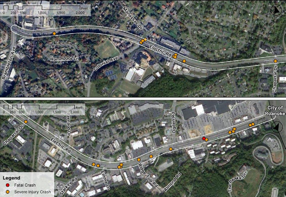
Electric Road is a major commercial corridor on the southern edge of the City of Roanoke. Electric Road provides an important connection between the City of Roanoke and Roanoke County. The corridor provides access to multiple shopping centers including Tanglewood, Promenade Park, and West Village, as well as industrial sites off of Starkey Road.
Several improvements have recently been completed along this eastern portion of Electric Road, between Ogden Road and the Route 220 interchange in 2021; a third lane was added between Ogden Road and Route 220 Southbound, with sidewalks and bicycle lanes on both sides of the road. Pedestrian signals and crosswalks were also installed on Electric Road, at South Peak Boulevard/Tanglewood Center Entrance, Elm View Road/Tanglewood Center Entrance, and Ogden Road.
In addition to the recently completed projects, a Diverging Diamond Interchange improvement at Route 220 is currently in progress.
There was one pedestrian crash at Atlantis Boulevard. The crash injured 2 pedestrians.
Safety Analysis Potential Strategies
The severe crashes are predominately angle crashes on this roadway and indicate a pattern of conflicts arising from drivers turning to and from the commercial accesses and side streets along the corridor.
Limit: 35 mph / 45 mph
2015-2023 Number of Lanes: 4 lanes / 6 lanes
Severe Injury Crashes: 27 Fatal Crashes: 1
Prevalent Crash Characteristics
Community Survey Rank: #2
Evaluate Restricted Crossing U-Turns (RCUT) or Thru-Cut improvements east of Colonial Avenue
• Because of the pattern of angle crashes at unsignalized intersections, RCUTs or thru-cuts east of the Colonial Avenue intersection could improve traffic safety and efficiency by reducing the number of conflict points.
• Additional study is required and should be evaluated following the construction and installation of the proposed improvements east of Starkey Road.
Consider an intersection study of Electric Road and Colonial Avenue
• The Electric Road and Colonial Avenue intersection has experienced a cluster of severe crashes. Due to the existing grade, the existing intersection angle, nearby school operations, and the proximity to the Manassas Drive intersection, a focused intersection study is required to provide comprehensive improvement recommendations at this location.
Glen Heather Drive to Brambleton Avenue
Electric Road is a major commercial corridor on the southern edge of the City of Roanoke. Electric Road provides an important connection between the City of Roanoke, the City of Salem, and Roanoke County. The corridor provides access to multiple shopping centers, including the Cave Spring Corners Shopping Center and Oak Grove Plaza, and connects to many residential communities.
Several improvements are already funded along the corridor, including pedestrian improvements at Postal Drive and Brambleton Avenue, and Restricted Crossing U-Turns at Glen Heather Drive and Stoneybrook Drive. Additionally, a SMART SCALE funded sidewalk project is in progress, from Glen Heather Drive to Grandin Road Extension, which will provide pedestrian access to Oak Grove Plaza.
The severe crashes are predominately angle crashes on this roadway and indicate a pattern of conflicts arising from drivers turning to and from the commercial accesses and side streets along the corridor.
Average Daily Traffic: 23,000 vehicles/day
Speed Limit: 45 mph
2015-2023
Severe Injury Crashes: 17
Fatal Crashes: 1
Prevalent Crash Characteristics
Number of Lanes: 4 lanes
Community Survey Rank: #3
Conduct a corridor study or a road safety audit for Electric Road (from Bower Road to Brambleton Avenue)
• A corridor study or Road Safety Audit (RSA) could be performed, south of the proposed RCUT improvements at Glen Heather Drive and Stoneybrook Drive. A study may be utilized to gather additional information, especially for hotspot locations that have experienced a cluster of serious crashes, for example, Cordell Drive and McVitty Road.
Evaluate Restricted Crossing U-Turns or Thru-Cut improvements
• This corridor currently has planned Restricted Crossing U-Turns to be installed at Glen Heather Drive and Stoneybrook Drive. Following construction, if crash severity and frequency is improved, similar implementations could be pursued at other intersections with additional study.
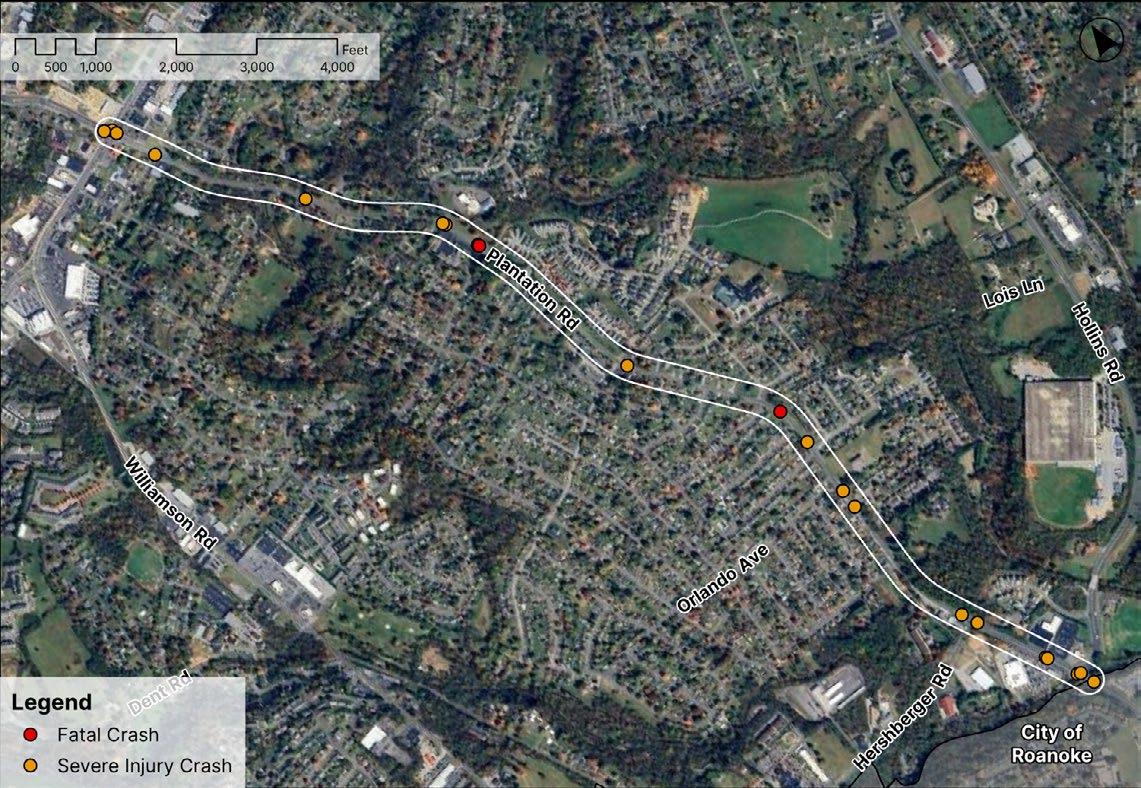
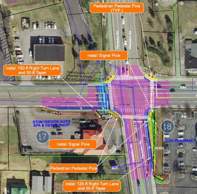
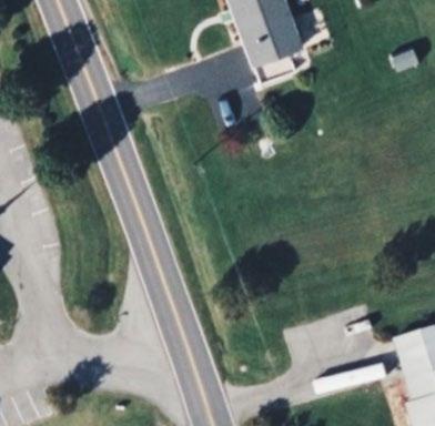
Williamson Road to Roanoke City Line
Plantation Road is a minor north-south arterial in Roanoke County. This corridor serves a primarily residential area lined by homes and churches. Plantation Road also provides access to Mountain View Elementary on Plantation Circle. There have been 20 serious crashes and 2 fatalities since 2015. The associated crashes are a mix of angle crashes, rear end collisions, and run off-road crashes; one third of the crashes occurred at night. Two of the serious crashes were bicycle or pedestrian collisions. Additionally, 6 of the 22 fatal and serious injury crashes involved drugs or alcohol, and 5 involved speeding.
Prevalent Crash Characteristics
Angle Crashes
Pedestrian1 Speeding
Safety Analysis Potential Strategies
Conduct a multimodal corridor study
Average Daily Traffic: 8,400-9,700 vehicles/day
Speed Limit: 40 mph
2015-2023
Severe Injury Crashes: 20
Fatal Crashes: 2
Number of Lanes: 2 lanes
Community Survey Rank: #4
Fixed Object Off Road Alcohol/Drugs
Given the varied nature of the crash patterns, a more focused corridor study is necessary for this segment of Plantation Road.
• Considering the residential surroundings, presence of Mountain View Elementary School, and an existing lack of bicycle/pedestrian facilities along Plantation Road, there could be an opportunity to promote active transportation in the corridor. Installing these facilities and associated traffic calming could eliminate bicycle and pedestrian collisions in this location and improve overall roadway safety. A future corridor study is required to specifically evaluate Plantation Road, as well as residents’ experiences, priorities, and overall vision for this segment.
Consider increasing enforcement along the corridor
• There is a prevalent pattern of crashes related to drugs, alcohol, or speeding. Increasing traffic enforcement along the corridor may help alleviate this issue.
Benois Road to Merriman Road
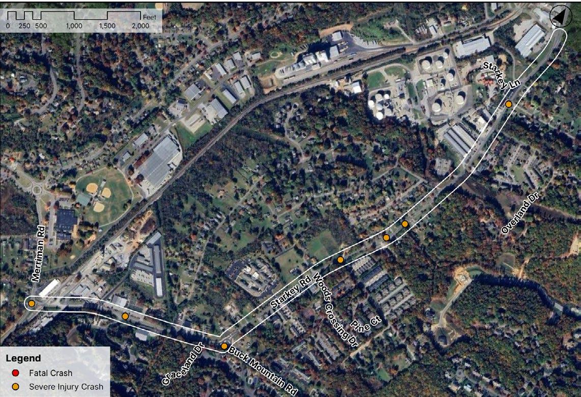
Completed roundabout at Starkey Road & Buck Mountain Road
Completed roundabout Road & Buck Mountain Road
Benois Road to Merriman Road
Starkey Road is a major north-south collector in southern Roanoke County. This section of Starkey Road is predominately surrounded by a mixture of residential and industrial uses, with few commercial businesses; many residences have driveway access directly on Starkey Road. A roundabout was recently completed at the intersection of Starkey Road and Buck Mountain Road.
Given that the type of severe injury crashes are varied and do not cluster in any particular locations along the Starkey Road segment, a corridor study is needed to examine the existing conditions of Starkey Road and develop specific safety opportunities. There is potential to implement multimodal transportation through this corridor with traffic calming measures, if desired by the surrounding communities.
Average Daily Traffic: 7,000-8,500 vehicles/day
Speed Limit: 35 mph
2015-2023
Severe Injury Crashes: 7
Number of Lanes: 2 lanes
Community Survey Rank: #6
Crashes along this corridor are typically angle crashes, rear end crashes, and involve senior drivers. Crashes do not cluster at a specific location and instead, are dispersed along the roadway.
Conduct a multimodal corridor study
• Given that the type of severe injury crashes are varied and do not cluster in any particular locations along the Starkey Road segment, a corridor study is needed to examine the existing conditions of Starkey Road and develop specific safety opportunities. Particularly with the recent completion of the Starkey Road and Buck Mountain Road roundabout, a corridor study would establish the existing conditions of Starkey Road, inclusive of the new roundabout, and other complementary implementations to improve the number and severity of crashes.
• A corridor study would provide an opportunity to collect user experiences along Starkey Road, determine commercial and industrial businesses’ operational needs, and compile residents’ goals for transportation in this area.
Roanoke City Line to Brambleton Avenue
Garst Mill Road is a major north-south collector in Roanoke County, leading into the City of Roanoke. The corridor runs through a predominantly residential area, with single-family detached and attached homes, as well as apartments. Garst Mill Road provides access to Garst Mill Park, the Cave Spring Corners Shopping Center, and the Brambleton Avenue commercial corridor.
There is a present demand for a sidewalk connection from the surrounding multifamily communities to the Cave Spring Corners Shopping Center and Brambleton Avenue.
With the surrounding residences and existing lack of bicycle and pedestrian facilities along Garst Mill Road, there is an opportunity to create multimodal connections along this corridor.
Average Daily Traffic: 6,800 vehicles/day
Speed Limit: 35 mph
2015-2023
Severe Injury Crashes: 7
Fatal Crashes: 1
Fixed Object Off Road
Number of Lanes: 2 lanes
Community Survey Rank: #7
Evaluate and install pedestrian improvements, specifically for a pedestrian connection to the Brambleton Avenue commercial corridor
• At a future time, additional sidepaths, bike lanes, or similar facilities could be considered as well, with complementary traffic calming interventions. Providing multimodal infrastructure along Garst Mill Road could prevent bicycle and pedestrian collisions in the future and promote active transportation options for these neighborhoods.
Back Creek Orchard Road to Tinsley Lane
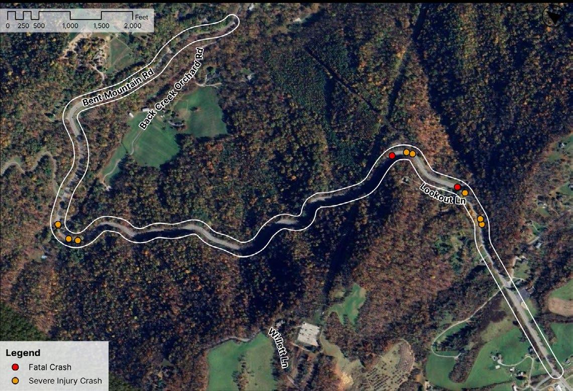
Back Creek Orchard Road to Tinsley Lane
Bent Mountain Road is a mountainous north-south corridor in southwestern Roanoke County. The roadway has sharp curves and steep elevation changes. The corridor experienced 47 total crashes from 2015 to 2023 and over 25% resulted in a fatal or serious injury. The fatal and serious injury crashes are predominately single-vehicle run off-road crashes, and all occurred at curves in the roadway.
Prevalent Crash Characteristics
Fixed Object Off Road Speeding Motorcycle
Safety Analysis Potential Strategies
Average Daily Traffic: 7,000 vehicles/day
Speed Limit: 55 mph
Severe Injury Crashes: 10
Fatal Crashes: 2
2015-2023
Number of Lanes: 2 lanes / 3 lanes
Community Survey Rank: #8
The severe crashes on this roadway are predominately the result of vehicles leaving the roadway.
Evaluate condition and spacing of existing chevrons; consider upgrades (such as reflective yellow strips) as necessary
• According to the VDOT Preferred CMF List, upgrading chevrons with fluorescent sheeting has a Crash Modification Factor of 0.65. Chevrons are present along much of the roadway, however, their condition should be evaluated in dim or dark conditions, and they may not be spaced to optimally delineate curves.
Consider shoulder or centerline rumble strips
• Installing shoulder or centerline rumble strips have associated CMFs of 0.83 and 0.55, respectively and could prevent run off-road collisions.
• Application of shoulder or centerline rumble strips should be limited to locations where there are significant roadway departure crashes and little, if any, bicycle traffic
Consider tree cutting at select curves, where possible (existing steep topography adjacent to roadway)
• Some of the curves are surrounded by thick foliage which may obscure the road ahead. Select tree cutting may help drivers better judge the severity of upcoming changes in roadway alignment and adjust their speed accordingly.
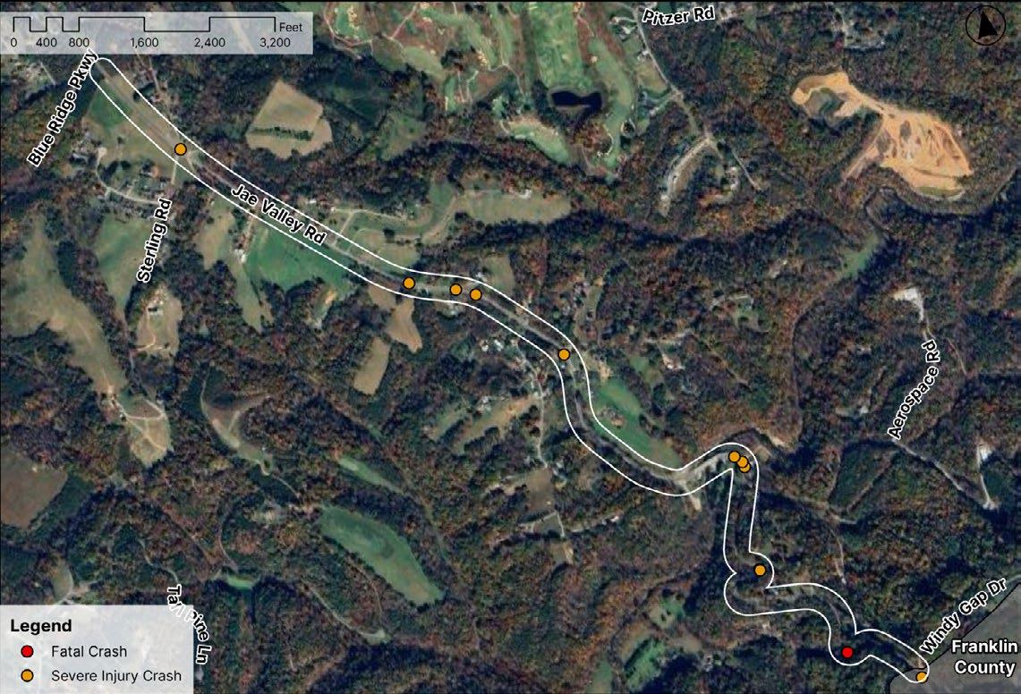
Blue Ridge Parkway to Franklin County Line
Jae Valley Road is a mountainous north-south corridor with steep elevation changes and sharp curves in southeastern Roanoke County. The fatal and serious injury crashes are predominately single-vehicle run off-road crashes. While these crashes are somewhat distributed along the corridor, three of the 12 serious crashes occurred at one sharp curve, near Jae Valley Park.
Prevalent Crash Characteristics
Fixed Object Off Road Speeding Rain
Safety Analysis Potential Strategies
Average Daily Traffic: 7,900 vehicles/day
Speed Limit: 55 mph
Number of Lanes:
2 lanes
Severe Injury Crashes: 11
Fatal Crashes: 1
2015-2023
Community Survey Rank: #9
The severe crashes on this roadway are predominately the result of vehicles leaving the roadway.
Evaluate condition and spacing of existing chevrons; consider upgrades (such as reflective yellow strips) as necessary
• According to the VDOT Preferred CMF List, upgrading chevrons with fluorescent sheeting has a Crash Modification Factor of 0.65. Chevrons are currently present along some of the roadway, however it does not appear that the current signage has fluorescent sheeting.
Consider installation of high friction surface treatment (HFST) at select curves
• High friction surface treatments (HFST) are pavement treatments that directly address crashes associated with friction demand issues, such as wet conditions or sharp roadway curves. FHWA reports show that HFST is estimated to reduce wet crashes by 83 percent and total crashes by 57 percent. HFST involves the application of high quality aggregate to the pavement using a polymer binder to restore and/or maintain pavement friction at high crash areas. The higher pavement friction helps motorists maintain better control in both dry and wet driving conditions. This corridor should be further studied to evaluate whether HFST would be an appropriate countermeasure; where over 70% of the 11 fatal/serious injury crashes were fixed object, run off-road collisions, improving driver control and braking capacity could reduce overall crash severity.
Catawba Valley Drive to Montgomery County Line
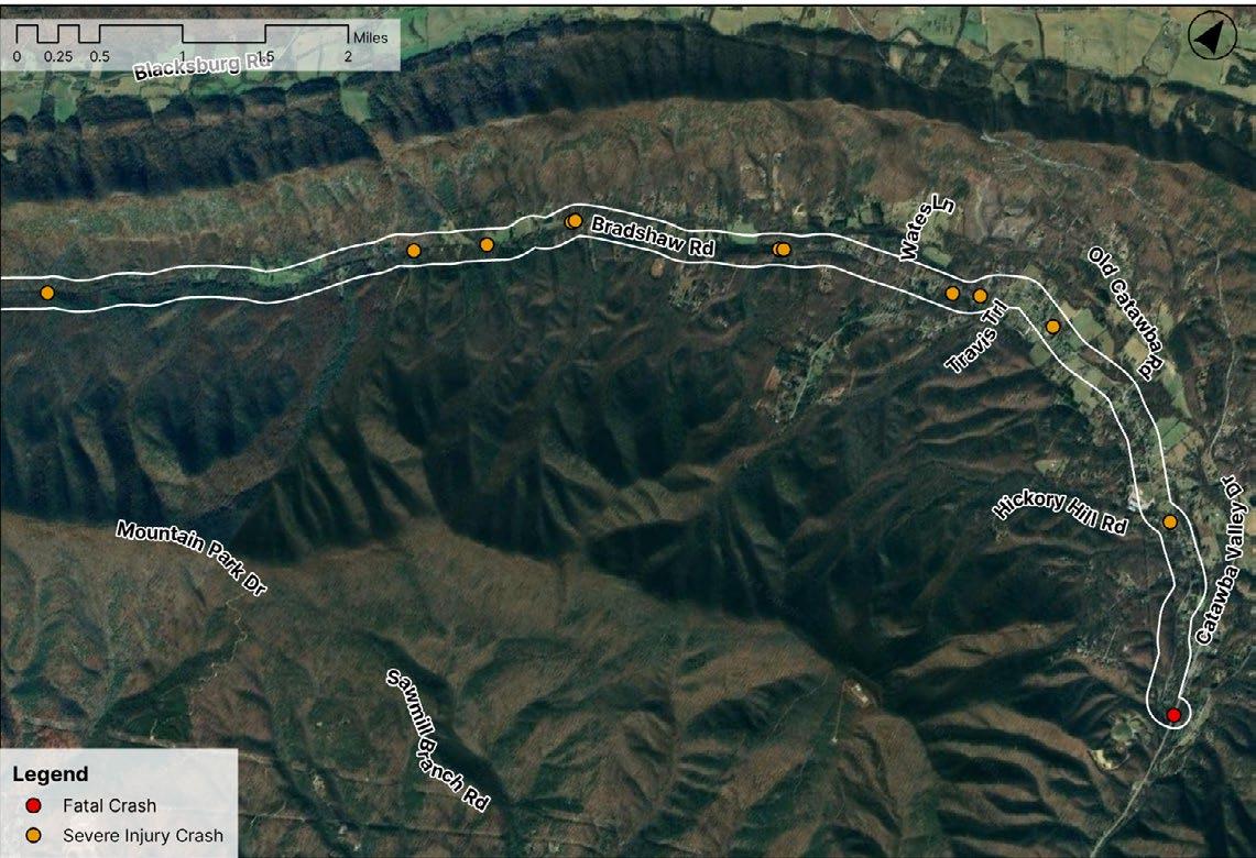
Catawba Valley Drive to Montgomery County Line
Bradshaw Road is a rural corridor in the northwestern portion of the county. The roadway is narrow and lacks a shoulder. The road is typically straight which may encourage speeding, and crashes tend to cluster around curves.
Safety Analysis Potential Strategies
Crashes are predominately the result of vehicles leaving the roadway.
(1) pedestrian crash at Fire Station #10
Average Daily Traffic: 2,700 vehicles/day
Speed Limit: 40 mph / 55 mph
Severe Injury Crashes: 11
Fatal Crashes: 1
2015-2023
Number of Lanes:
2 lanes
Community Survey Rank: #10
Evaluate condition and spacing of existing chevrons; consider upgrades (such as reflective yellow strips) as necessary
• The most common severe injury crashes along this corridor are from colliding with a fixed object, off road. If existing signage is in need of improvement, upgrades could better alert drivers of changing road conditions.
Consider installing centerline or shoulder rumble strips
• At the community meetings, several residents noted that bicyclists frequently travel on this corridor. Because they use the shoulder to allow vehicles to pass, bicyclists recommended against shoulder rumble strips. If shoulder rumble strips are considered, additional shoulder width beyond the rumble strip could accommodate bicycle travel.
• If additional shoulder width beyond the rumble strip cannot be achieved, application of shoulder or centerline rumble strips should be limited to locations where there are significant roadway departure crashes and little, if any, bicycle traffic.
• At the community meetings, several residents noted that bicyclists frequently travel on this corridor. Due to the length of the corridor, the use of bicyclists, and the pedestrian collision, this roadway would benefit from a corridor study to better understand the existing conditions and appropriate implementations for Bradshaw Road.
THIS PAGE IS INTENTIONALLY BLANK
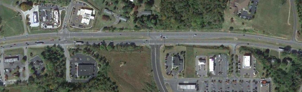
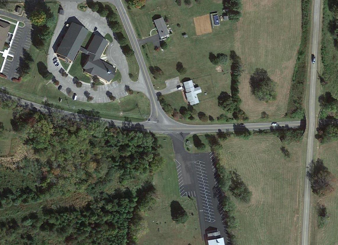
Challenger Avenue (Route 460) is a principal arterial in the northeastern portion of Roanoke County. Challenger Avenue provides an important connection between the City of Roanoke, Roanoke County, Botetourt County, and other locations to the east and west across the state.
From Challenger Avenue, Valley Gateway Boulevard provides access to the Kroger Shopping Center, as well as industrial businesses off of Integrity Drive. Since 2015, there have been 86 crashes at the Valley Gateway Boulevard intersection, including 3 severe injury crash and 1 fatal crash; three of the four severe injury crashes involved drivers running the red light.
Average Daily Traffic: 34,000 vehicles/day
Speed Limit: 45 mph
2015-2023
Severe Injury Crashes: 3
Fatal Crashes: 1
Prevalent Crash Characteristics
Number of Lanes: 4 lanes
Community Survey Rank: #1
Angle Crashes Distracted Red-Light Running
Review signal timings for Challenger Avenue corridor for potentially longer all-red times
• The crash data indicates a pattern of red-light running at this intersection. Increasing the all-red time at a signalized intersection provides safety benefits by creating a buffer period during which all approaches to the intersection display a red signal. This reduces the likelihood of collisions caused by red-light-running, as it gives drivers who inadvertently enter the intersection late additional time to clear it before cross-traffic starts
Conduct a speed study to evaluate lowering the speed limit from the city boundary to this intersection
Three of the four crashes involved redlight running, including the fatal crash
• Conducting a speed study on a corridor provides safety benefits by identifying prevailing vehicle speeds and patterns of speeding behavior. This data helps determine whether speed limits are appropriately set, promoting uniform travel speeds and reducing crash risks. The study also highlights areas requiring interventions, such as traffic calming measures or enforcement strategies, to enhance safety for all road users, including pedestrians and cyclists
Evaluate moving the existing Valley Gateway Boulevard stop bar and extending the existing concrete median closer to the Challenger Avenue intersection
• Moving the stop bar and median further into the intersection would reduce the distance to turn left from Valley Gateway Boulevard onto Challenger Avenue, which may reduce crashes
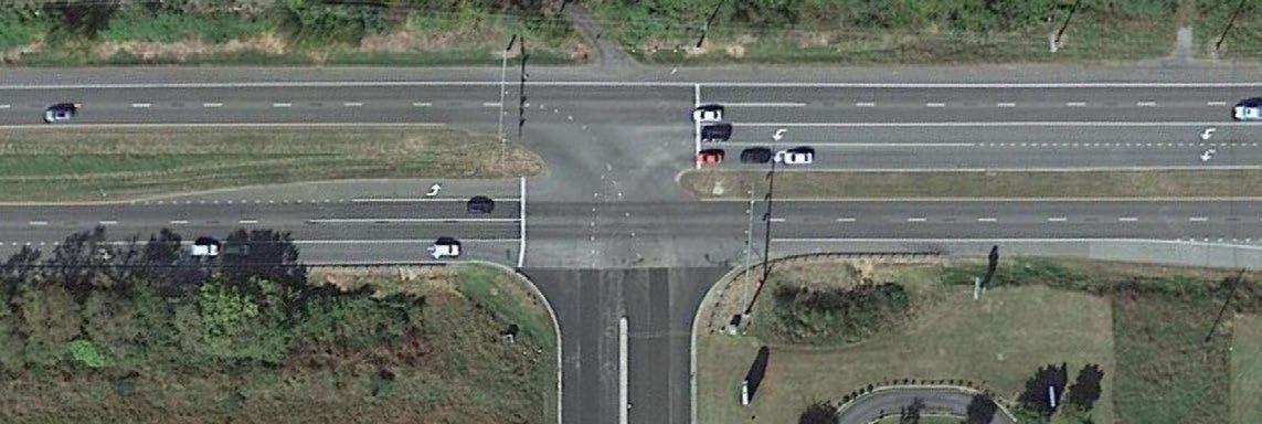
Context
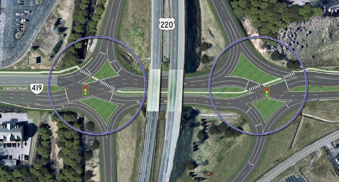
North Electric Road is a major corridor and principal arterial that serves much of Roanoke County. The signalized intersection has seen 33 crashes since 2015, including 4 serious injury crashes. The serious injury crashes are from angle crashes associated with northbound vehicles on Electric Road, making the left-turn maneuver onto I-81.
Prevalent Crash Characteristics
Average Daily Traffic: 7,800 vehicles/day
Speed Limit: 45 mph
2015-2023
Severe Injury Crashes: 5
Fatal Crashes: 0
Number of Lanes: 3 lanes
Community Survey Rank: #3
Safety Analysis Potential Strategies
Consider reconfiguration of the intersection to reduce the width of the I-81 median, shortening the turning distance of NB left-turning movements
• Existing intersection configuration is excessively wide with long crossing distances and times, which is likely a contributing factor to angle crashes
• Northbound vehicles making the left turn may not fully account for the median length in addition to crossing the southbound lanes
All four severe injury crashes were angle collisions
Evaluate reduction of southbound approach to one through lane
• Further north, beyond the Loch Haven Drive intersection, a second through lane is added to the southbound approach
• Maintaining only one through lane would reduce size of the intersection and allow drivers to more quickly clear the intersection
• Feedback from the Fall 2024 community meeting describes high peak hour volumes in this area and that the signal timings for the Loch Haven intersection and the Exit 141 intersection should be reviewed (especially if reducing southbound approach is studied)
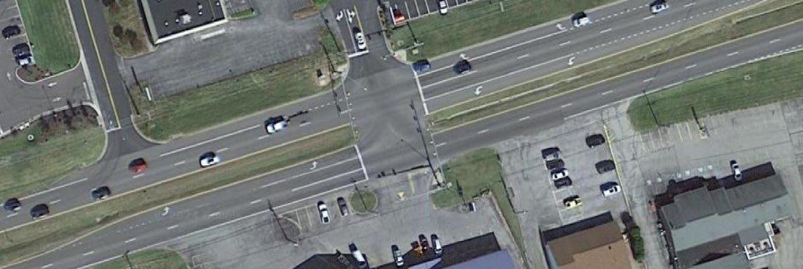
Washington Avenue is as a major east/west corridor that serves as a primary entrance and thoroughfare for the Town of Vinton. The signalized intersection with the East Vinton Plaza shopping center has seen 51 crashes since 2015. The crashes are mostly angle crashes associated with left-turning movements, predominately from eastbound vehicles turning into the shopping center.
Prevalent Crash Characteristics
Five out of six severe injury crashes were angle collisions
Average Daily Traffic: 19,000 vehicles/day
Speed Limit: 45 mph
2015-2023
Severe Injury Crashes: 6
Fatal Crashes: 0
Number of Lanes: 4 lanes Community Survey Rank: #4
Consider increasing left-turn lane offset to improve visibility for eastbound vehicles turning left into the East Vinton Plaza
• According to the VDOT Preferred CMF List, increasing the left-turn lane offset has a Crash Modification Factor of 0.644 across all crash types
• Increasing the offset improves driver visibility of oncoming traffic and reduces the time and distance a turning vehicle spends in the intersection
Consider access management improvements of commercial parcel on south leg of intersection
• There are three driveways to commercial properties in close proximity of the intersection. Access management improvement enhance safety by reducing conflict points, such as left-turns and driveways near the intersection, which lowers the risk of crashes. These changes also improve traffic flow by minimizing disruptions, reducing delays, and enhancing overall operational efficiency. Additionally, better access management can support safer pedestrian and cyclist movements and create a more predictable driving environment
Conduct a speed study of the Washington Avenue corridor
• Conducting a speed study on a corridor provides safety benefits by identifying prevailing vehicle speeds and patterns of speeding behavior. This data helps determine whether speed limits are appropriately set, promoting uniform travel speeds and reducing crash risks. The study also highlights areas requiring interventions, such as traffic calming measures or enforcement strategies, to enhance safety for all road users, including pedestrians and cyclists
Context
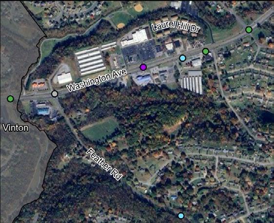
Hardy Road is as a major east/west corridor that serves as a primary entrance and thoroughfare for the Town of Vinton. The unsignalized intersection has seen 21 crashes since 2015. The associated crash profiles indicate a pattern of drivers turning onto Hardy Road from Feather Road without yielding to oncoming traffic.
Prevalent Crash Characteristics
Average
Four of the six crashes were angle collisions from drivers traveling south on Feather Road disregarding the stop sign or not appropriately yielding and colliding with a vehicle on Hardy Road.
Install sight distance improvements
• At the NE corner, the existing trees are present on an upward slope that could inhibit sight distance of westbound traffic on Hardy Road
• Addressing this issue by trimming the obstructive trees or regrading the slope is crucial to improving safety at this busy intersection
Add advanced warning signage
• Advanced warning signage could be installed to alert oncoming traffic on Hardy Road about the upcoming intersection and traffic entering the roadway from Feather Road
• This advanced warning helps drivers prepare to slow down, stop, or yield, reducing the likelihood of crashes caused by sudden braking or failure to notice the intersection. It enhances awareness and reaction time, benefiting all road users
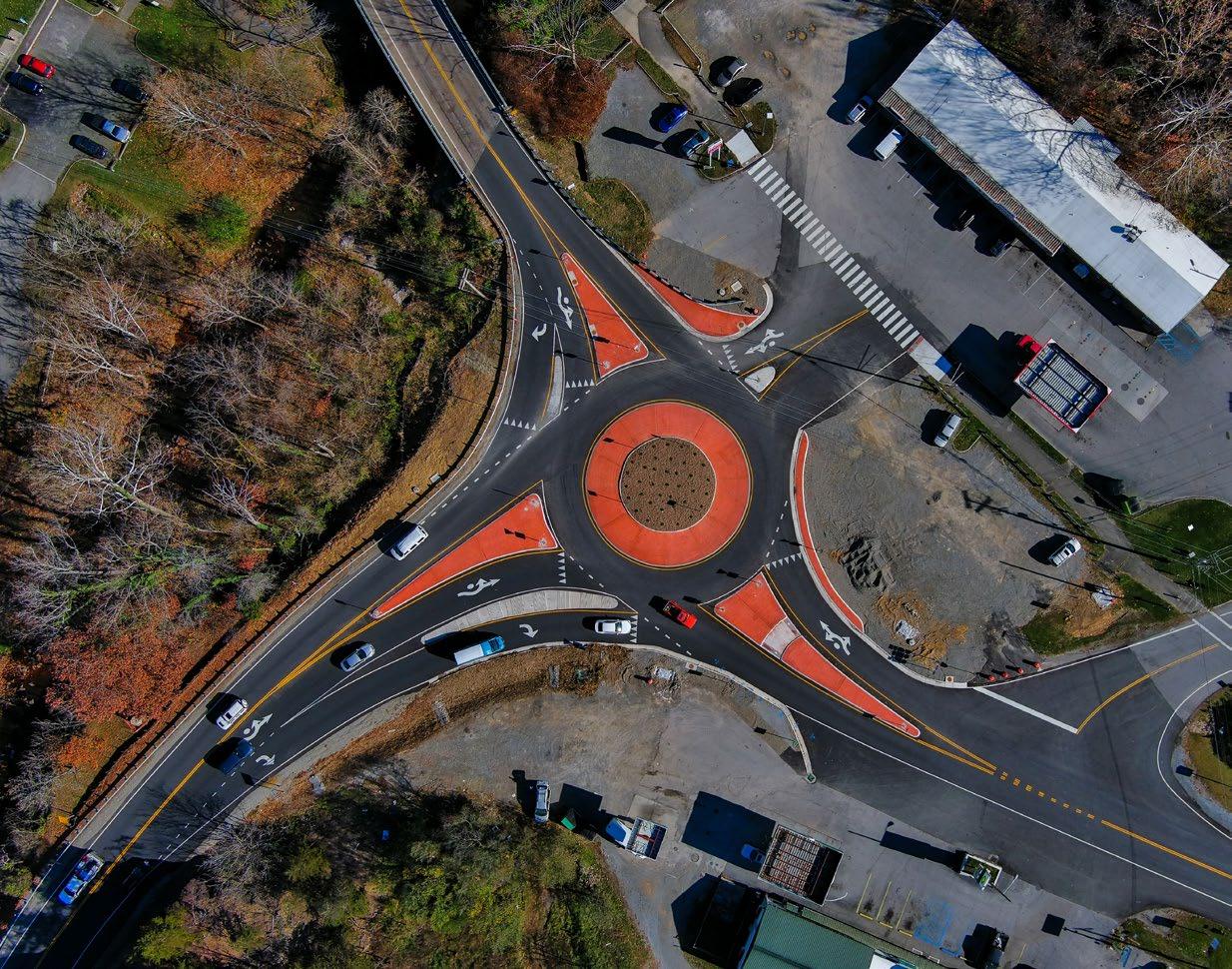
Evaluate a roundabout improvement
• A roundabout would provide a reduction in necessary sight distance, a traffic calming measure through the intersection, and the ability to alert drivers in all directions to the presence of the intersection
• The circular design of a roundabout forces vehicles to slow down, lowering the likelihood of highspeed collisions. Roundabouts also reduce the potential for severe crashes, such as T-bone and head-on collisions, and improve pedestrian safety by shortening crossing distances and providing refuge islands
Context
Plantation Road is a principal arterial and major connection between I-81 and northern Roanoke County. The unsignalized intersection has seen 33 crashes since 2015, including 4 serious injury crashes. The associated crash profiles indicate a pattern of conflicts arising from drivers turning to and from the multiple commercial entrances.
Prevalent Crash Characteristics
Angle Crashes
Safety Analysis
Average Daily Traffic: 12,000 vehicles/day
Number of Lanes:
Speed Limit: 45 mph
2015-2023
Severe Injury Crashes: 4
4 lanes with a TwoWay Left-Turn Lane
Community Survey Rank: #8
Three of the four severe injury crashes were angle collisions from drivers turning into a commercial entrance
Potential Strategies
Evaluate extension of the existing two-way left-turn lane (TWLTL) further north
• There is an existing TWLTL on Plantation Road that begins to taper off 150’ from the intersection. Extending the TWLTL will remove left-turning vehicles from the through lanes and store those vehicles in the median area until a safe gap in opposing traffic is available to complete the turn.
• According to the VDOT Preferred CMF List, the addition of a TWLTL on a four lane road has a Crash Reduction Factor of 55%.
Consider opportunities for access management
• There are currently 6 full-access commercial driveways in close proximity in the vicinity of the intersection. The abundance of access points introduces undue opportunities for crashes and creates excessive conflict points.
• In addition, the existing driveways do not meet VDOT access management design standards which mandate a minimum distance of 1,320’ between the end of an interchange off-ramp and fourlegged intersections. Limiting the number of commercial driveways will improve safety and bring the intersection closer to current VDOT standards.
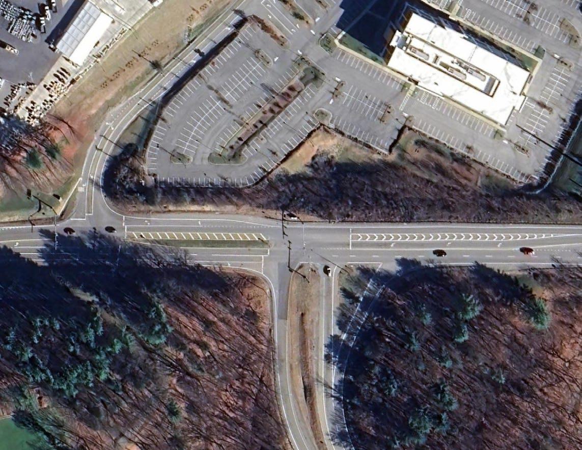
Shadwell Drive, Sanderson Drive, and Hollins Road are major collectors that serve the north end of Roanoke County. The unsignalized intersections have seen 35 crashes since 2015, including 4 serious injury crashes. The 4 severe crashes were angle crashes and collisions with fixed-objects, off-road. Both angle crashes occurred on Shadwell Drive, with vehicles turning out of Hollins Road or Sanderson Drive; collisions with a fixed object occurred on each side of the railroad crossing.
A nearby October 2024 rezoning included a proffered condition indicating the developer would work with Roanoke County to construct a left turn lane from Sanderson Drive onto Shadwell Drive to help mitigate additional traffic that the new development will generate. A plan, timeline and funding for this improvement has not yet been determined.
Safety Analysis Potential Strategies
Two of the four severe injury crashes were angle collisions
Two of the four severe injury crashes involved hitting a fixed object, off road
Angle & fixed object - off road crashes
Variety of crash types
Average Daily Traffic
Shadwell Drive: 7,200 vehicles/day
Sanderson Drive: 5,600 vehicles/day
Hollins Road: 5,300 vehicles/day
Speed Limit: 40 mph
Severe Injury Crashes: 4
Prevalent Crash Characteristics
Consider installation of a left-turn lane on Shadwell Drive onto Sanderson Drive
• The installation of a left-turn lane could reduce collisions by providing a designated space for vehicles waiting to turn.
Sight distance improvements
• Hollins Road and Sanderson Drive would both benefit from tree cutting to improve driver visibility when turning onto Shadwell Drive.
Consider guardrail installation
• Guardrails act as a barrier to shield motorists from more severe outcomes in the event of a crash, reducing the risk of collisions with fixed objects. They also provide a visual cue to guide drivers and improve awareness of potential hazards.
Evaluate a peanut roundabout installation
• A peanut roundabout would directly address angle collisions while providing a traffic calming effect to this intersection.
Conduct a speed study and evaluate a speed limit reduction
• Lowering the speed limit to 35 mph can lead to fewer and less severe crashes, as lower speeds provide drivers with more time to respond to road conditions and other vehicles. Currently the speed limit drops from 45 to 40 mph as drivers travel west through the intersections.
Consider bicycle and pedestrian accommodations as part of improvement projects at this intersection
• A variety of crash types occur at this intersection. With future development, existing and new residents will be served by this intersection. Incorporating bike-ped infrastructure as part of the intersection improvement could contribute to traffic calming and slow down approaching vehicular traffic, as well as provide alternative transportation means.
The Safe Streets and Roads for All Notice of Funding Opportunity (NOFO) defines equity as:
Equity is the consistent and systematic fair, just, and impartial treatment of all individuals, including individuals who belong to underserved communities that have been denied such treatment, such as Black, Latino, Indigenous and Native Americans, Asian Americans and Pacific Islanders, and other persons of color; members of religious minorities; lesbian, gay, bisexual, transgender, and queer (LGBTQ+) persons; persons with disabilities; persons who live in rural areas; and persons otherwise adversely affected by persistent poverty or inequality.
Several federal tools are available to help identify disadvantaged communities, including the USDOT’s Equitable Transportation Community (ETC) Disadvantaged Areas dataset and the Council on Environmental Quality’s Climate and Economic Justice Screening Tool (CEJST).
The ETC dataset, managed by USDOT, uses census tracts to identify communities facing transportation insecurity and other transportation-related disadvantages. This tool provides insights into how limited access to transportation impacts marginalized communities, helping guide decisions toward more equitable solutions. According to USDOT, transportation insecurity occurs when “people are unable to get to where they need to go to meet the needs of their daily life regularly, reliably, and safely.” The dataset incorporates data from the 2020 Census to assess the effects of transportation underinvestment on communities. Indicators from five areas of disadvantage serve as the basis of the ETC. The indicators include:
• Transportation Insecurity
• Environmental Burden
• Social Vulnerability
• Health Vulnerability
• Climate and Disaster Risk Burden
Each census tract is given an overall index score based on these indicators. A community is considered disadvantaged if the overall index score places it in the 65th percentile of all census tracts.
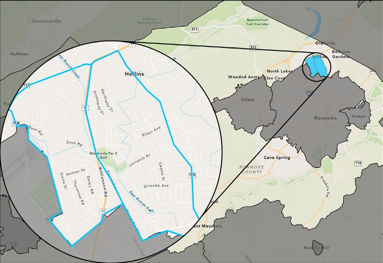
Figure 18 highlights disadvantaged communities in Roanoke County in blue, according to the ETC. The Plantation Road corridor and associated intersections fall in the highlighted area.
According to the explorer, there are 6,600 people in Roanoke County living in a disadvantaged census tract, approximately 7% of Roanoke County’s 96,929 residents.
The CEJST is an alternative tool utilized to define disadvantaged populations. Developed by the Council on Environmental Quality, the dataset also uses 2020 Census data and census tracts to find indicators of overburdened or underserved communities. These communities are either located on Federally Recognized Tribal Lands or meet at least one of the eight burden categories, which include:
• Climate Change
• Energy
• Health
• Housing
• Legacy Pollution
• Transportation
• Water and Wastewater
• Workforce Development
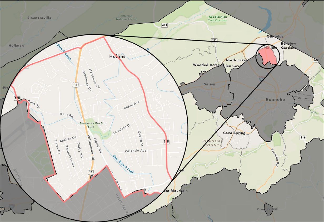
Figure 19 highlights areas considered underserved by CEJST. In this instance, the ETC and CEJST areas overlap. Approximately 6,600 of the 96,929 residents in Roanoke County live in disadvantaged Census tracts, approximately 7%.
The Safe Streets and Roads For All NOFO includes people living in rural areas as individuals who belong to underserved communities. A rural area is defined as located outside of a U.S. Census-designated urban area with a population of 200,000 or more.
Figure 20 highlights the areas that do not fall into the U.S. Census urban areas, thus are defined as rural areas. Many of the High-Injury Network corridors and the priority project locations are located in rural areas. Approximately 19,000 of the 96,929 people in Roanoke County (or 20%) live in rural areas, according to the 2020 American Community Survey.
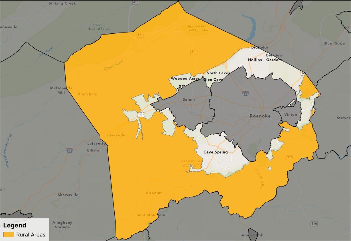
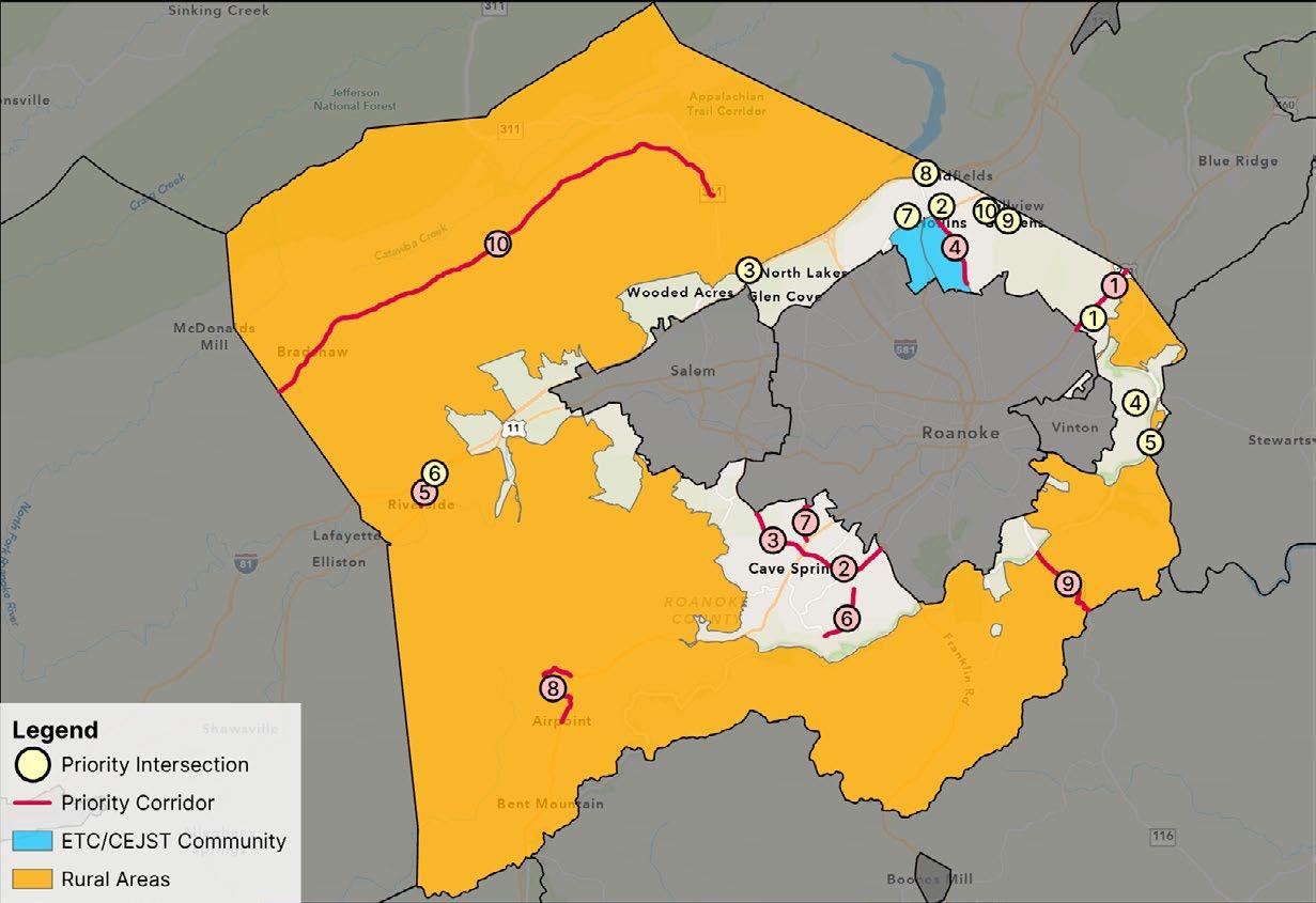
Figure 21 shows the intersection of the priority project locations based on this Safety Action Plan, feedback from the community surveys, and underserved communities. Three priority locations target areas identified by the Equitable Transportation Community Explorer and the Council on Environmental Quality’s Climate and Economic Justice Screening Tool. Seven priority locations are in or closely border rural areas.
As part of the Safe Streets and Roads For All (SS4A) process, it is important for Roanoke County to review its current plans and policies to identify opportunities for improvements. There are several regional plans that contribute to the development of Roanoke County’s transportation system.
Adopted by the Roanoke County Board of Supervisors in September 2024, the Roanoke County 200 Plan represents the first significant update to the Roanoke County Comprehensive Plan since 2005. The 200 Plan provides recommendations to guide natural and cultural resources, community facilities, land use and housing, and transportation in Roanoke County through the County’s bicentennial anniversary in 2038. The 200 Plan contains numerous formal recommendations for improving the safety and functioning of Roanoke County’s transportation system, including specific recommendations for each of Roanoke County’s eleven (11) Community Planning Areas. These recommendations come in the form of both broad strategies and specific projects.
Prepared and adopted by the RVTPO with significant input from localities, the Roanoke Valley Transportation Plan serves as the federally required Long Range Transportation Plan (LRTP) for the RVTPO service area. The latest version of the Roanoke Valley Transportation Plan was adopted in 2023, with a plan horizon of 2045. This plan outlines regional transportation needs and priorities and serves as the foundation for the development of the RVTPO’s Transportation Improvement Program (TIP).
Safety is discussed throughout the RVTP. Safety data trends since 2017 are shown with a focus on fatal and serious crashes as well as bicycle and pedestrian crashes. The Roanoke Valley Transportation Plan also includes a list of all transportation projects currently
funded in the RVTPO service area, and a list of short-term and longterm priority projects for localities and public agencies to pursue in the future. The plan identifies over 100 projects that align with the goal of SS4A to eliminate fatalities and reduce injuries on a multimodal transportation system. An opportunity is available to supplement this list with projects found in the SS4A Comprehensive Safety Action Plan.
RVTPO’s 2015 Regional Pedestrian Vision Plan provides a coordinated and strategic approach for advancing walking as a means of transportation in the Roanoke Valley. This plan identifies where pedestrian infrastructure is most needed in the RVTPO service area based on the potential for residents, employees, shoppers, diners, and other visitors to access nearby destinations. The primary goal of the Pedestrian Vision Plan is listed as improving safety for pedestrians, and projects are provided that work towards this goal. The studies and projects recommended by this Action Plan can expand upon the Pedestrian Vision Plan and move Roanoke County towards a safer transportation network.
The 2012 Bikeway Plan was prepared and adopted by the Roanoke Valley Area Metropolitan Planning Organization (RVAMPO), the precursor to RVTPO. This plan provides a coordinated and strategic approach to developing a regional bicycle network in the RVTPO service area. The Bikeway Plan provides recommendations for bicycle infrastructure that would advance bicycling as a means of transportation in the Roanoke Valley by enhancing connectivity between activity centers, cultural resources, and other points of interest.
The 2020 Rural Bikeway Plan was prepared and adopted by the Roanoke Valley-Alleghany Regional Commission (RVARC), as RVTPO only serves the urbanized area of the Roanoke Valley. This plan identifies bicycle infrastructure improvements for localities to consider in the rural parts of the RVARC service area. The Rural Bikeway Plan also identifies why people bicycle in these rural areas, where exactly they are bicycling, and the quality of existing bicycle facilities.
In addition to their existing plans, Roanoke County may look towards implementing additional policy and process changes to gather focused data at specific locations, encourage appropriate driver behavior, and initiating changes to land use.
Goal: Discourage undesirable or illegal behaviors that are not necessarily addressed through engineering countermeasures.
Increasing law enforcement patrol would discourage or address dangerous or illegal driver behaviors. However, local law enforcement is constrained (with staffing shortages, budget, etc.) and additional collaboration is needed to identify feasibility and limitations.
Based on survey responses and discussions with community meeting attendees, there is a high concern for speeding on County roadways. At the time of this report, Virginia legislation only permits speed cameras in school zones and work zones. The installation of speed cameras in these locations would provide enforcement without the physical presence of law enforcement and could encourage drivers to be more aware of their speeds elsewhere. Additional budget will need to be allocated to review and process violations. This recommendation will necessitate
changes to County Code and will require discussion with Roanoke County Police before adopting.
As described with reviewing signal timings, Roanoke County residents are very concerned with red-light running behavior at intersections. Red light cameras are permitted in Virginia localities, however, the quantity of cameras is restricted by population. Additional budget will need to be allocated to review and process violations. This recommendation will necessitate changes to County Code and will require discussion with Roanoke County Police before adopting.
Goal: Dedicate time and budget for a focused and nuanced study of a specific intersection or corridor.
Where an intersection or corridor experienced a high number of fatal and serious injury crashes without a clear crash pattern, further study is needed for developing recommendations. A specific intersection or corridor study would gather additional information about roadway conditions and learn about resident experiences, priorities, and future goals for that particular location.
Speeding is a top concern for Roanoke County residents, and high vehicle speeds lead to more severe crashes. A speed study in select locations could identify areas where drivers tend to excessively exceed the posted speed limit and could serve as an element of project prioritization for design solutions. Changes to the roadway design and the implementation of traffic calming measures can also be used to facilitate lower speeds where speed limit reductions are needed.
Goal: Coordinate with property owners to create safer conditions around high-priority intersections
Where several entrances are present near an intersection, there is an opportunity to consolidate these access driveways to reduce the number of conflict points. Ease of access would improve traffic flow of nearby intersections. Better access management would benefit not only drivers, but adjacent property owners and businesses. Implementation would require ongoing coordination and negotiation with private property owners.
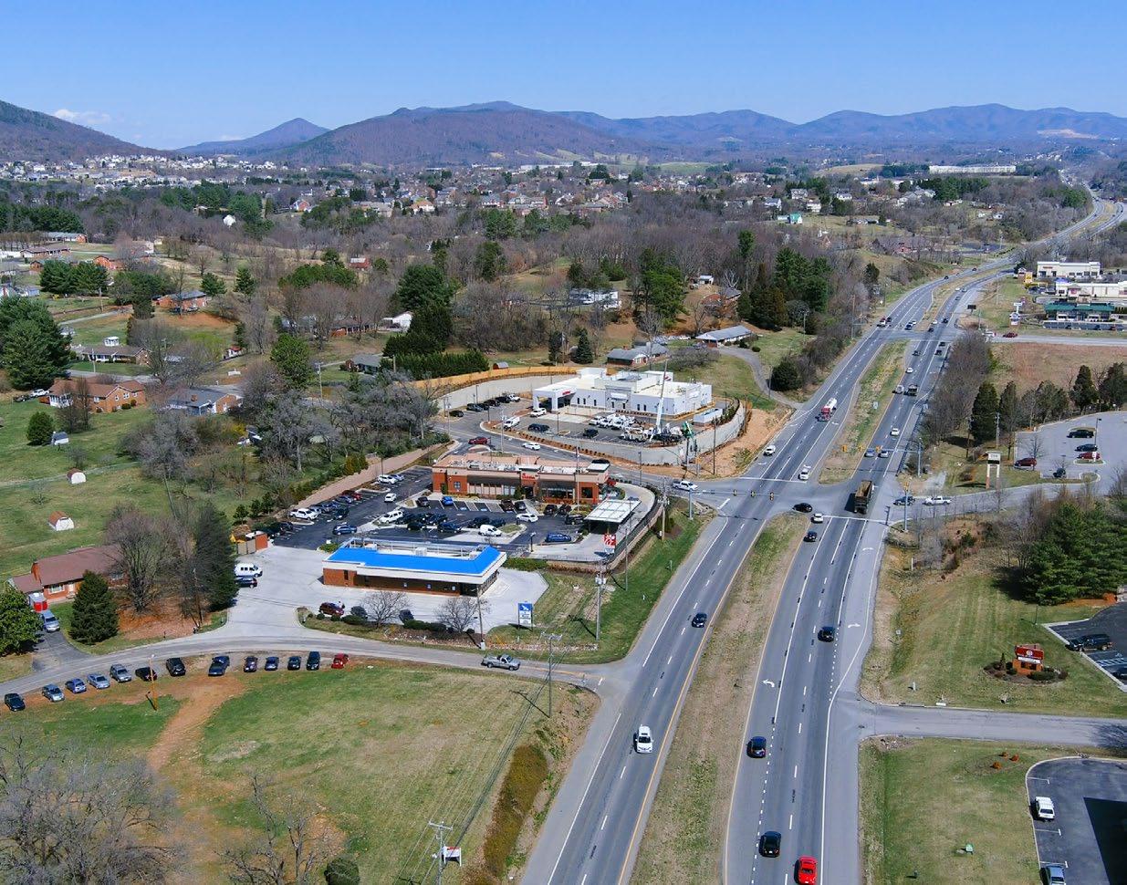
Route 460 Challenger Avenue
The built environment plays a major role in roadway safety. This chapter highlights potential improvements to road and intersection design in Roanoke County, and provides a list of potential projects to address safety concerns at locations identified in this study.
Goal: Improve roads and intersections to increase driver visibility, encourage drivers to slow down and be aware of their surroundings, and facilitate safe bicycle and pedestrian movement.
Installation of new signage or improving existing signage may alert drivers of upcoming road conditions. Signage improvements could include increasing the size of existing signs, adding flashing lights, or adding reflectivity to improve visibility to drivers.
Adequate sight distance is vitally important in creating safe intersections and entrances. In certain locations, there are short-term opportunities for improving sight distance by cutting back trees and landscaping. Improving sight distance through grading or other design interventions would require further study and additional coordination with involved parties.
Intersections are often hotspots for collisions, as an area of changing traffic conditions. Safety can be improved at intersections through smaller projects (such as adding sidewalk, curb bumpouts, etc.) or larger projects (such as reducing the size of the intersection, installing a roundabout/Restricted Crossing U-Turn (RCUT)/Thru-Cut, etc.). Redesigning an intersection may vary in scope but should ultimately slow down drivers, improve visibility, and accommodate different modes of transportation, as applicable.
Adding a turn lane or improving an existing turn lane could improve traffic flow and reduce collisions. Where there is not currently a turn lane, adding a turn lane would allow a vehicle to wait in a designated location before turning when there is adequate time to clear an intersection. An existing turn lane could be improved with the installation of a left-turn offset, which could improve visibility at intersections where the turning vehicle must yield to oncoming through traffic.
Where the majority of the fatal and serious injury crashes were run off-road incidents, the installation of a guardrail would be a direct solution for preventing future crashes at key locations. Similarly, the installation of centerline or shoulder rumble strips would alert drivers of lane departure and promote correction. Rumble strips should only be applied in areas where there are significant roadway departure crashes and little, if any, bicycle traffic. If bicycle traffic is present, additional shoulder width beyond the rumble strip should be considered.
Reviewing and revising signal timings could improve traffic flow and alleviate pressure at certain intersections. Based on community input, uncoordinated signals may be contributing to driver frustration and potentially increasing risky and dangerous behavior. Along corridors with coordinated signals such as Challenger Avenue, the existing timing plan should be reviewed. Additionally, many survey respondents and community meeting attendees observed frequent red-light running behavior; longer all red timings could improve crashes due to red-light running. Enforcement and policy should additionally be considered to discourage dangerous driver behavior.
(Brambleton Avenue to Roanoke City Line)
Starkey Road
(Benois Road to Merriman Road)
Garst Mill Road
(Roanoke City Line to Brambleton Avenue)
Bent Mountain Road
(Back Creek Orchard Road to Tinsley Lane)
Evaluate and install pedestrian improvements, specifically to the Brambleton Avenue commercial corridor
Consider installing centerline or shoulder rumble strips (Includes evaluating bicycle traffic and widening shoulder width beyond rumble strip area)
Jae Valley Road
(Blue Ridge Parkway to Franklin County Line)
Consider tree cutting at select curves, where possible2 $ Short
Review signal timings; potentially longer all-red times1
Consider lowering speed limit from City boundary to this intersection
Evaluate moving existing stop bar and extend existing concrete median closer to intersection
Consider reconfiguration of the intersection to reduce the width of the I-81 median, shortening the turning distance of NB left-turning movements
Evaluate reducing southbound approach to one through lane
Consider reviewing signal timings for the Loch Haven intersection and the Exit 141 intersection, especially if reducing the southbound approach is studied Free response feedback from the Fall 2024 community meeting describes high
Consider potential coordination with City of Roanoke
Under the Safe Streets and Roads For All (SS4A) grant program, localities may apply for funding to explore supplemental planning and demonstration activities. Planning activities aim to gather more information through studies, plans, or audits and demonstration activities include implementations related to infrastructure, behavior, or technology. Infrastructure activities could include conducting temporary ‘quick-build’ projects, temporary street or lane closures (road diets), or MUTCD engineering studies. Localities that would like to address driver behavior and education may pilot educational campaigns, provide training (such as focusing on bus drivers and bike-pedestrian awareness), or develop projects around Safe Routes to School, encouraging best practices in student pick-up and drop-off. A variety of technological implementations could be pursued, such as signal timings and upgrades for bike-pedestrian prioritization or signal preemption for emergency vehicles, installation of red-light and speed cameras, and data collection.
Road & Colonial Avenue (intersection)
Electric Road
(From Bower Road to Brambleton Avenue)
Corridor/intersection study or road safety audit
Speed study
Plantation Road
Starkey Road
Bradshaw Road
Washington Avenue
(Area around the East Vinton Shopping Center and William Byrd School campus)
High incidences of crashes at this intersection, however, no clear crash pattern. Intersection study required to collect and analyze data
Planned RCUTs towards City of Roanoke, however, no current plans for Electric Road from Bower Road to Brambleton Avenue
Pattern of FSI crashes involve speeding as well as involving a pedestrian. Corridor study to gather information on bicycle-pedestrian needs of predominately residential area.
Consider corridor study to evaluate if newly constructed roundabout at Buck Mountain Road improved crashes along this corridor
Feedback from community members described bicyclists frequenting this corridor. Corridor study to gather information regarding this rural corridor, bicyclist routes, and other challenges/opportunities (see sheet X for more information).
If warranted by speed study, consider speed limit reduction in the area approaching intersection; see sheets 60-61 for Washington Avenue and sheets 66-67 for Shadwell Drive Shadwell Drive & Sanderson Drive/Hollins Road (intersection)
Use flex-post and/or temporary curb to extend existing concrete median on Valley Gateway Boulevard closer to intersection; see sheets 56-57 Requires coordination with and approval by VDOT
Pattern of senior drivers involved in the FSI crashes
Opportunities include education, training and information on the CORTRAN program which is a curb-to-curb rideshare program for Roanoke County residents who are 65 or older or who are disabled.
of motorcyclists involved in the FSI crashes
Pattern of speeding in FSI crashes as well as involving pedestrians
Collect data on vehicle speed and pedestrian counts/ location (only short segment of sidewalk on Plantation Road)
Review signal timings at this intersection and adjacent intersections (including southern intersections in City of Roanoke) Requires coordination with VDOT and the City of Roanoke
Review signal timings at this intersection & Loch Haven Drive
coordination with VDOT
Administering
VDOTSMART SCALESMART SCALE evaluates proposed transportation projects based on certain criteria (improving safety, reducing congestion, increasing accessibility, contributing to economic development, promoting efficient land use, and affecting the environment). The scored criteria determines prioritization of funds.
Highway Safety Improvement Program (HSIP)
The Highway Safety Improvement Program (HSIP) is intended to facilitate the goals of the Strategic Highway Safety Plan. The purpose of this plan is to implement safety improvements in Virginia.
Roanoke County is ineligible to apply directly for HSIP funds and must work with VDOT to request VDOT submit projects on behalf of Roanoke County
• Highway improvements
• Transit- and rail-capacity expansion
• Bicycle and pedestrian improvements
• Transportation Demand Management (Park & Ride facilities) Federal and State NoVaries based upon the application year
• Projects consistent with Virginia’s Strategic Highway Safety Plan
• Correcting or improving a hazardous road location or feature, or address a highway safety problem
• Projects based on crash experience, crash potential, crash rate, or other relevant safety data
• Curve delineation
• Pedestrian Crossings
• Edge/centerline rumble strips FederalNoNo maximum, but award amount likely under $1M
VDOTHSIP (cont.)
• Be listed under 23 U.S.C. 148(a)(4)(B) or (a)(11); and
• Comply with other Title 23 requirements
Transportation Alternatives Program (TAP)
Expanded under the Bipartisan Infrastructure Law (BIL), the Transportation Alternatives Program (TAP) is intended to provide funding for nonmotorized transportation.
• Projects pertaining to nonmotorized transportation
• Expand travel choice for daily needs, strengthens local economy, improves quality of life, and protects the environment
Federal Yes, 20% Funding awards between $200,000 and $600,000
(Part
The Safe Routes to School (SRTS) initiative is part of the VDOT TAP program. SRTS program’s purpose is to encourage students, including those with disabilities, to walk or bike to school, by establishing safer bike-ped connections and reducing traffic
Revenue Sharing VDOT’S Revenue Sharing program enables localities to match investment with the state, in order to fund construction and/or improvement of highway systems
• Walkabout mini-grants to assess existing walking and biking conditions
• Program grants
• Infrastructure grants
FederalThe Virginia SRTS Program is a locallyadministered reimbursement program. For new applicants, provides 100% of total funding with no match required. However, applicants are still encouraged to leverage funding from other sources. Varies
• Bicycle and pedestrian improvements
• Corridor widening and stormwater management improvements
• Traffic calming
• Green infrastructure
State Yes, 50% A locality may apply for a maximum of $10M per biennial cycle (or $5M per fiscal year) and the maximum lifetime matching per project is $10M. This limitation includes any allocations transferred to the project.
Up to $2.5M per fiscal year of these requested funds may be specified for maintenance projects.
DMV Virginia Highway Safety Office (VAHSO)
USDOT & Local MPO Surface Transportation Block Grant (STBG) Program
The intent of the VAHSO grant program is to reduce the number of fatalities, injuries, and related economic losses from traffic collisions in Virginia.
Initiatives to:
• Reduce alcohol/impaired driving
• Promote occupant protection
• Reduce aggressive driving and speeding
• Collect and analyze traffic records/data
• Promote bicycle-pedestrian safety
• Promote motorcycle safety
• Promote roadway safety
As part of the Bipartisan Infrastructure Law (BIL), the Surface Transportation Block Grant (STBG) program provides flexible funding for transportation improvement needs.
• Installation/deployment of current and emerging intelligent transportation technologies
• Protective features, including natural infrastructure, to improve the experience of an eligible facility
• Projects to enhance travel and tourism
FederalNoFunding is based on population ratio
Carbon Reduction Program (CRP)
As part of the Bipartisan Infrastructure Law (BIL), the CRP provides funding to develop carbon reduction strategies and for projects to reduce transportation carbon dioxide emissions. Strategies must be developed in consultation with MPOs.
• Bike lanes
• Traffic management
• Public transportation
• Pedestrian facilities
• Alternative fueling/charging infrastructure
FederalNoVirginia is expected to receive nearly $166 million in C R P funding from fiscal year (F Y) 2022 to F Y 2026. Funds are awarded in proportion to population.
Administering Agency
American Infrastructure with Sustainability and Equity (RAISE) Grant
As part of the Bipartisan Infrastructure Law (BIL), the Rebuilding American Infrastructure with Sustainability and Equity (RAISE) program provides investment towards transportation initiatives that create a significant local or regional impact.
• Highway, bridge, or other road projects
• Public transportation projects
• Any other surface transportation infrastructure project that the Secretary considers to be necessary to advance the goals of the program
Safe Streets and Roads For All (SS4A)
Supplemental Planning and Demonstration Activities Grant
Safe Streets and Roads For All (SS4A) Implementation Grant
See sheets 100-101 for expanded description and possible activities directly applicable to this Safety Action Plan
Federal Yes, 20% Varies significantly
The SS4A Implementation Grant provides funding towards project and strategy implementation as outlined in this Action Plan.
Federal Yes, 20% Varies significantly
THIS PAGE IS INTENTIONALLY BLANK
The Roanoke County Comprehensive Safety Action Plan is a commitment along with strategies and actions to reduce fatal and serious injury crashes on roadways across the County. This Plan can serve people across agencies, departments, organizations, and interest groups to unite around the importance of roadway safety and a positive traffic safety culture.
Action items identified by this plan should be used by the County and partners on projects, policies, and programs. Additionally, the County should consistently measure how actions are making roadways safer and saving lives.
Roanoke County should monitor the progress and impact of individual actions related to each strategy. Evaluation is essential for the data-driven approach of the Comprehensive Safety Action Plan. There must be accountability to the commitment of eliminating traffic deaths and severe injuries. If certain actions are not successful, not moving fast enough, or not working for another reason, the County and partnering agencies should assess and modify actions as needed. Measuring progress and success can be accomplished using a data dashboard. Routine updates can be made to the dashboard when new projects are funded, designed, and implemented to highlight changes and mark milestone efforts related to increasing roadway safety. This tool can provide insight into a number of metrics, including, but not limited to:
• Number of fatal and serious injury crashes
• Total Crashes
• Crashes along the HIN and changes in crash rates over time
• Crashes involving bicycles and pedestrians
• Crashes resulting from high posted speeds
• Crashes occurring during particular weather conditions
• Crashes in each context area (Urban, Rural)
The dashboard is available for public viewing here, or by using the following link:
https://www.arcgis.com/apps/dashboards/ a85a20fee3104a60b8355544a654578f
Along with tracking several performance measures and the use of a data dashboard, annual reporting will provide the County an opportunity to reflect on accomplishments and communicate steps toward eliminating fatal and severe injury crashes.
Roanoke County will publish an annual report on the progress of the SS4A Comprehensive Safety Action Plan. The report will be published in January or February of each year and may include the following:
• Updated crash statistics with a focus on fatal and serious injury crashes
• Projects completed or beginning construction
• Proven Safety Countermeasures deployed
• Funding associated with safety projects
Roanoke County has developed the Comprehensive Safety Action Plan with the goal of full transparency. The Action Plan will be publicly available on Roanoke County’s website. Interim documents like the annual report will also be posted on the website.
https://www.roanokecountyva.gov/
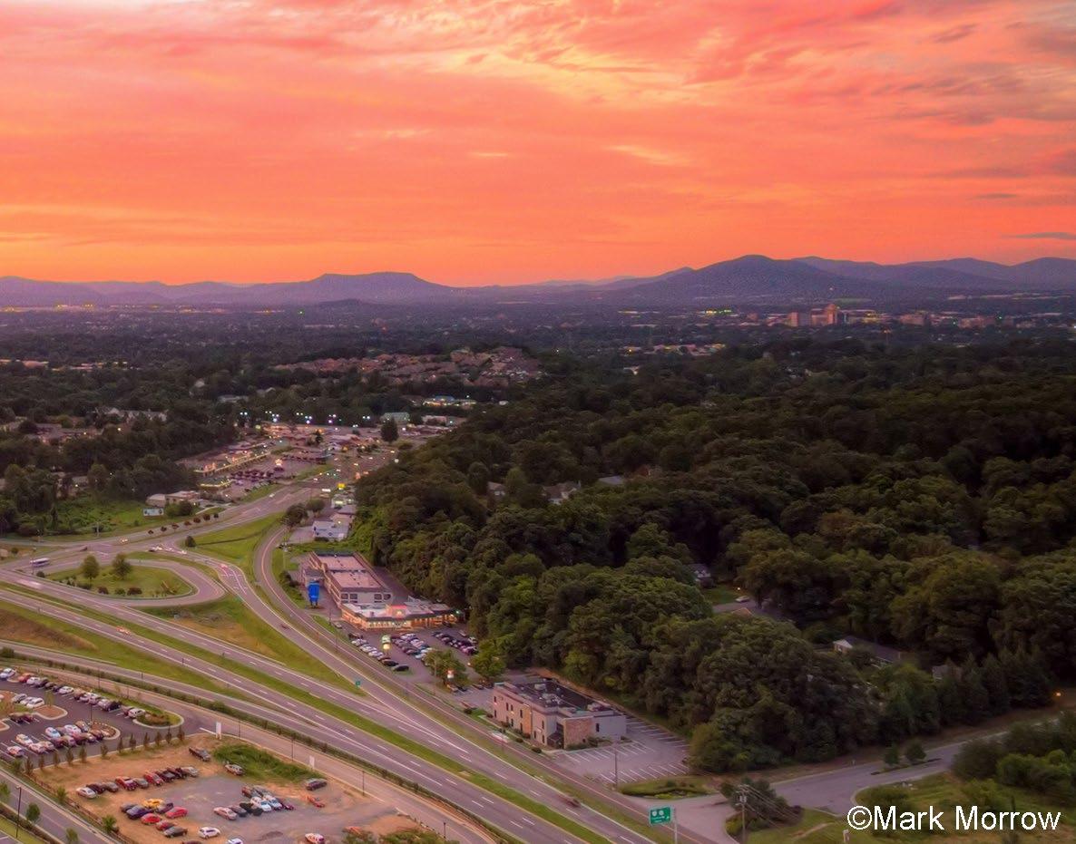
Priority Corridor #1
Challenger Avenue (Route 460) - Roanoke City Line to Botetourt County Line
Three projects along this corridor were funded in 2021:
1. Route 460 at West Ruritan Road Intersection Improvements: $7.5 million SMART SCALE/STBG award
2. Route 460 Intersections from Carson Road to Huntridge Road: $2.8 million SMART SCALE/STBG award
3. Route 460 and Alternate Route 220 Intersection Improvements: $21.8 million SMART SCALE/STBG award
Construction for all projects is anticipated in 2026 and 2027.
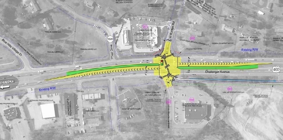
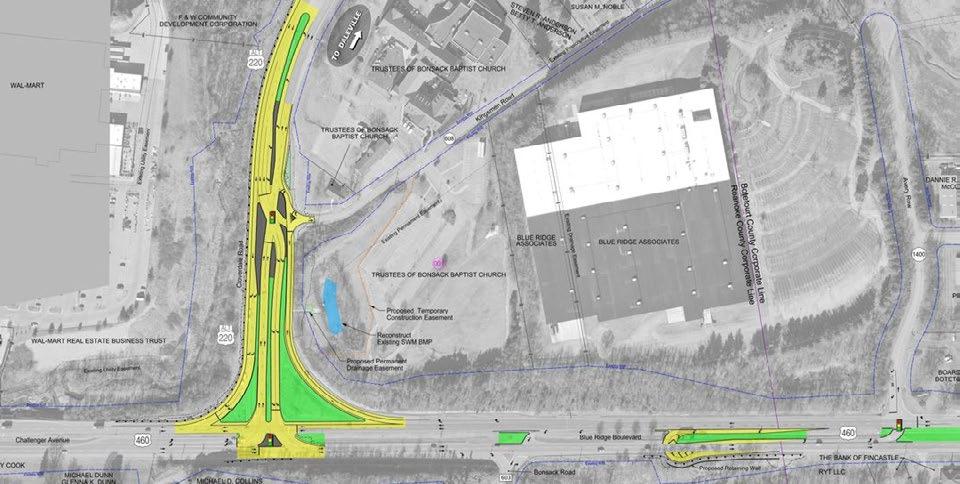
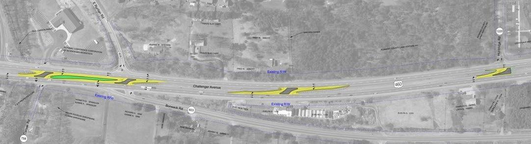
Priority Corridor #2
Electric Road (Route 419) - Brambleton Avenue to the Roanoke City Line (East)
Three projects along this corridor were funded in 2019 and 2021:
1. Route 419/Route 220 Diverging Diamond Interchange: $17.5 million SMART SCALE/STBG award
2. Route 419 Streetscape Improvements, Phase 2 (Ogden Road to Starkey Road): $18.5 million SMART SCALE/STBG award
Construction for the Diverging Diamond Interchange is anticipated in early 2025 and construction for the streetscape improvements is anticipated in 2026.
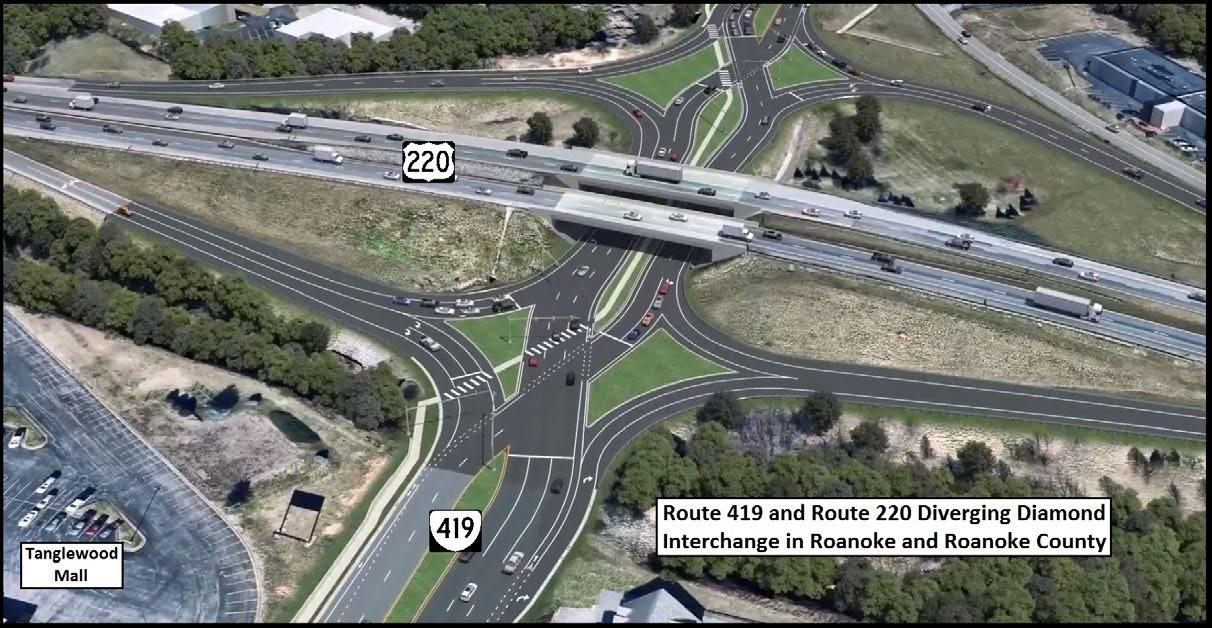
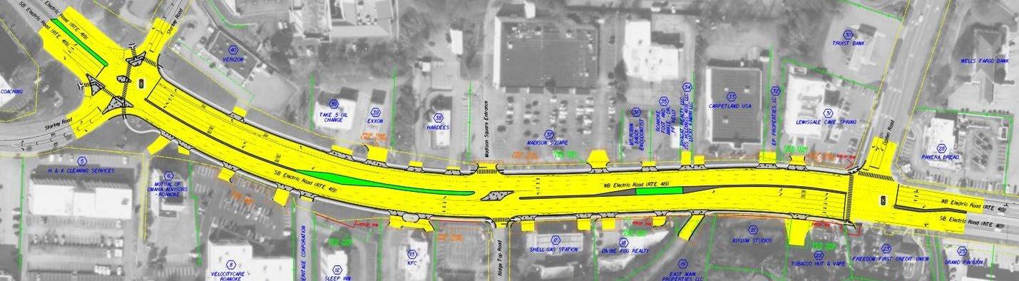
Electric Road (Route 419) - Brambleton Avenue to Glen Heather Drive (West)
Three projects along this corridor were funded in 2023:
1. Route 419/Electric Road Safety Improvements (Stoneybrook Drive to Grandin Road Extension): $6.6 million SMART SCALE award
2. Route 419 Pedestrian Crossing Improvements at Brambleton Avenue and Postal Drive: $3.9 million SMART SCALE award
Construction for all projects is anticipated in 2027.

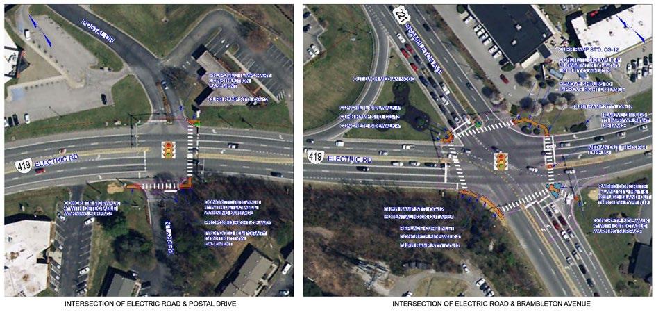
Starkey Road - Benois Road to Merriman Road
Construction is completed on a project to convert the previously existing “T” intersection at Starkey Road and Buck Mountain Road to a roundabout.
Total project funding: $5.8 million in Surface Transportation Block Grant, Revenue Sharing, Secondary Six-Year Program and SMART SCALE funding
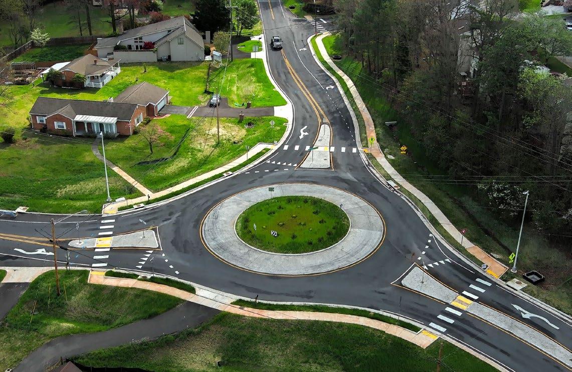
Priority Intersection # 1/Corridor #5
West Main Street - West River Road to Pleasant Run Drive
SMART SCALE application submitted in August 2024 for West Main Street (Route 11/460) at Dow Hollow Road Safety Improvements
STBG Leverage: $4 million | SMART SCALE Request: $36.1 million
Total Estimate: $40.1 million
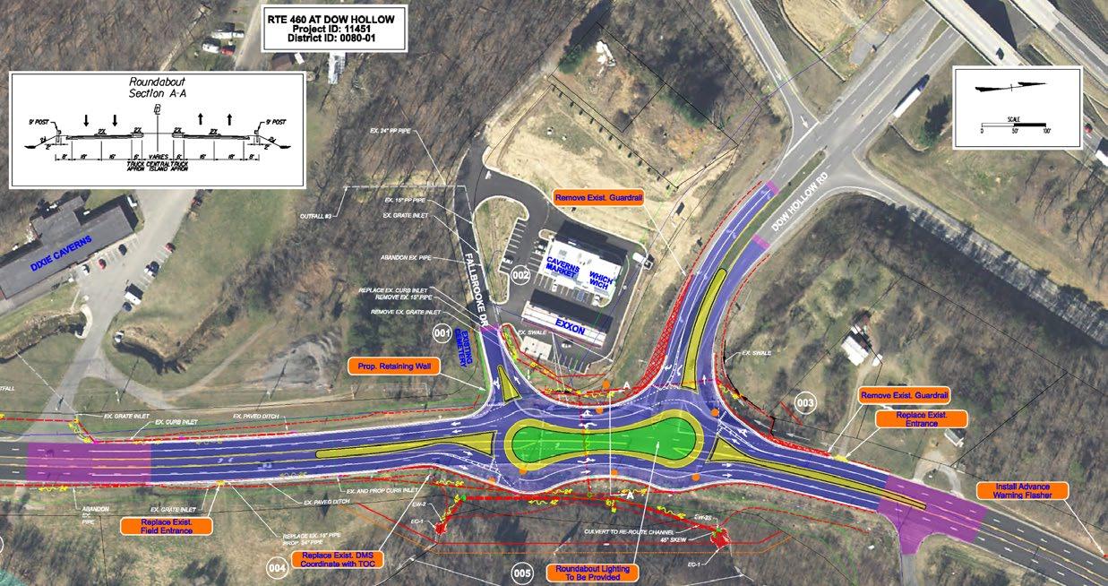
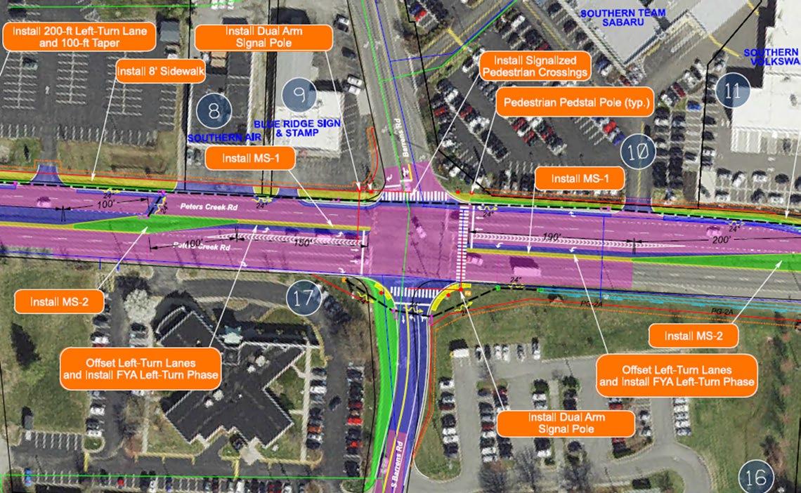
Plantation Road - Williamson Road to Hershberger Road
SMART SCALE Application submitted in August 2024 for Peters Creek Road/ Williamson Road Multimodal Safety Improvements (Wood Haven Road to Plantation Road) including the Peters Creek Road/Barrens Road and Williamson Road/ Plantation Road intersections.
Total estimate: $107.7 million