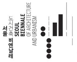
Land Architecture, Land Urbanism: City of Mountain Ranges, Waterways, and Wind Breezes - Drawing of the Seoul’s Next 100 years
DATES
01.09.2023
29.10.2023
PLACES
Songhyeon Green Plaza
Seoul Hall of Urbanism & Architecture
Seoul Citizens Hall
DIRECTOR
Byoung Soo Cho (General director)
Noh Hee Young (Director of Opening Ceremony and Marketing)
GLOBAL STUDIOS CURATORS
Eui Young Chun (Thematic Exhibition Curator)
Jinyoung Lim (Guest Cities Exhibition Curator)
Sang Hoon Youm (Guest Cities Exhibition Curator)
Sara Kim (On-site Project Curator)
Leif Høgfeldt Hansen (Global Studios Curator)
WEBSITE 2023.seoulbiennale.org
LEIF HØGFELDT HANSEN
Dear Professor Orazio Carpenzano, I hope this letter finds you well. You have previously been involved in arrangements connected to the Seoul Biennale for Architecture and Urbanism. I am writing to you as the current Global Studios Curator for the 4th Seoul Biennale in 2023.
Seoul Biennale for Architecture and Urbanism is, as you probably are aware, one of the most significant events in Asia for displaying architectural ideas and projects –and this time, it is directed by South Korean architect Byoung Soo Cho (See attached introduction video).
I would be pleased to invite you, with students in the Architectural section at the Sapienza Università di Roma, to participate in the Global Studios section of the biennale. Global Studios is a part of the biennale that unifies studios from 40 universities worldwide to discuss the future of megacities. This time it focuses on the part of a biennale master plan for a future sustainable green Seoul that links North and South with green bridges. Currently, studios from Cooper Union, Harvard University, Pratt Institute, Aalto University, IAAC Barcelona, Tongji University, SUTD Singapore, University of Tokyo, Monash University and several others are joining the 2023 biennale in Seoul.
According to the ambition of the biennale of making a future overall ‘Green’ plan for Seoul for the coming 100 years, the Global Studios has to do the type B assignments of the master plan: 3 bridges (1000-1500 meters long) crossing the Hangang river.
The bridges should be a sustainable future vision of connecting green public areas from the southern to the northern parts of Seoul by designing bridges with public functions, which can contain future mini-city and park environments with ‘soft’ traffic. In this future vision, transportation is managed by AI. (See brief)
The material will be exhibited during the biennale from 1st September to 1st November 2023, published on the net, and in a book/ catalogue. I enclose a link to the overall video, the brief for the biennale and a master plan map for Seoul’s potential 100 years of ‘green’ development.
For now, I think the enclosed material is enough for you and other professors to discuss if it has an interest for the Lab. at the university. It will be possible to do the assignment during the spring semester of 2023.
I will send more detailed material if you are interested.
SBAU 2023
Global Studios Curator
Hope to hear from you, and please feel free to ask any questions.
Kind regards,
Leif Høgfeldt Hansen
Global Studio Curator 4th Seoul Biennale for Architecture and Urbanism 2023
ORAZIO CARPENZANO
Sapienza University of Rome - Studio Leader
Dean of the Faculty of Architecture
Frame, Weft, Fabric.
Architecture of a Bridge for Seoul
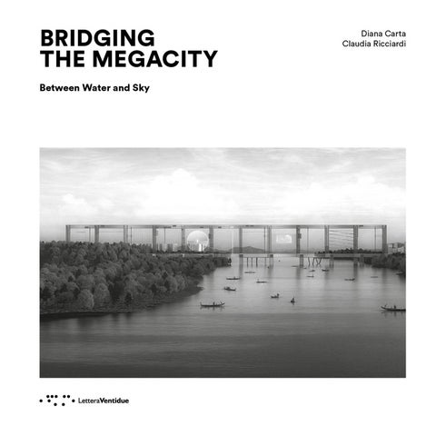
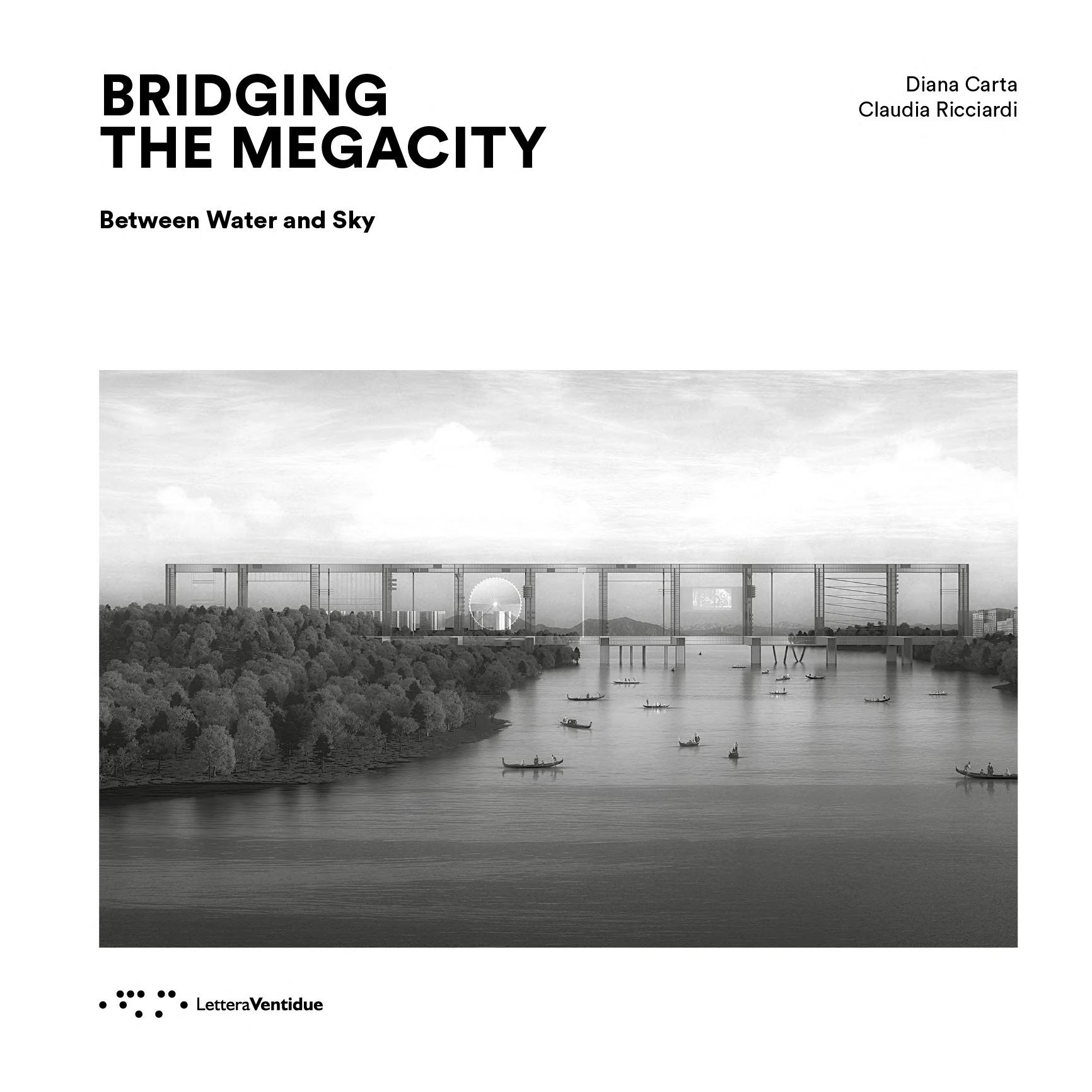
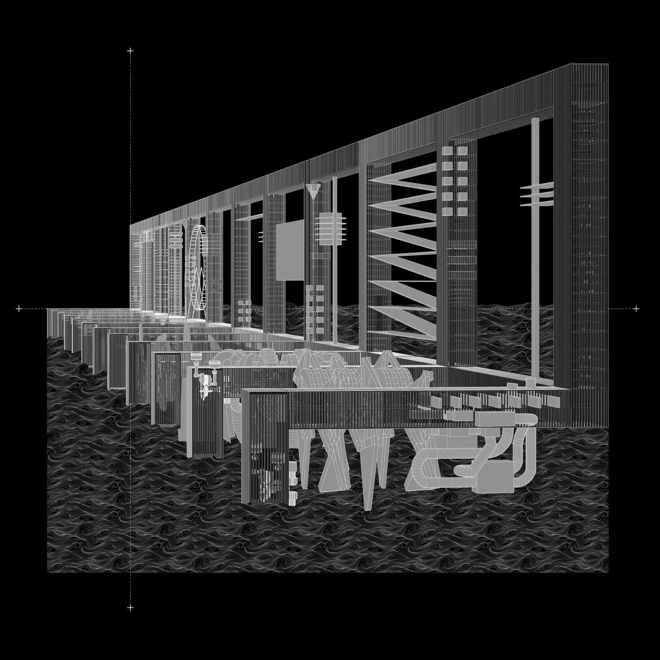
Eleven grand structural frameworks, each measuring 150 meters per side, forge a permeable relationship between the city and the landscape. This connection embodies a significant and essential facet of Seoul’s urban vision in its singular transition between artifice and nature, mediated by the fluid vector of the Hangang. At the same time, the beam – conceived as a sieve –intercepts and captures substantial mechanical fragments, potential pieces of a future landscape. Within this envisioned panorama, playful and spiritual elements merge, while energetic forces intermingle with social currents.
Within the vast landscape frames, the expansive structure accommodates devices harnessing renewable energies such as wind and water, thereby fostering conditions for the emergence of vegetative, natural, or agriculturally productive ecosystems. Simultaneously, the immutable character of the beam transforms into a body inhabited by ephemeral, adaptive, and mutable presences which collectively animate the urban narrative and embrace the essence of a ‘city-event’. In relation to the vibrant surface of the Han River, the
beam is duplicated and inverted, thus affording the possibility of articulating an authentic aquatic city – both floating and suspended. In doing so, the grand square-meshed beam kneels upon the river and descends upon the water, both physically and symbolically. The pillars, therefore, serve not merely structural ends but also create anchorage points that integrate a diversity of river-related activities.
Thus emerges a habitable condition, where the lacunar structure of the bridge permits the fusion of water and sky, yielding an atmospheric architecture in which entities intermingle and coexist.
The linear trajectory of the beam accommodates both pedestrian and vehicular movements. Vertical elements, coupled with an overhead linear system, form the basis for residential spaces, services, and communal areas that, from a panoramic perspective, partake in the osmotic relationship between city and nature. The bridge is a Hyper-lieux, open to both a synthetic interpretation and a slow, richly layered reading replete with multiple decipherments: linear, areal, and punctual components that encapsulate a potent iconic essence while simultaneously permitting
Telaio, Trama, Ordito.
Architettura di un Ponte per Seoul
Undici grandi telai strutturali, ciascuno di 150 metri per lato, creano una relazione permeabile tra la città e il paesaggio. Questa connessione rappresenta un aspetto significativo ed essenziale della visione urbana di Seoul nella sua peculiare transizione tra artificio e natura, mediata dal vettore fluido dell’Hangang.
Allo stesso tempo, la trave, concepita come un setaccio, intercetta e cattura grandi frammenti meccanici, potenziali pezzi di un paesaggio futuro. All’interno di quest’ultimo, elementi ludici e spirituali si fondono, mentre le componenti energetiche si mescolano con quelle sociali.
All’interno delle grandi cornici paesaggistiche, l’ampio telaio ospita dispositivi per l’utilizzo di energie rinnovabili, come il vento e l’acqua, e crea le condizioni per la presenza di ecosistemi vegetali, naturali o legati alla produttività agricola. Al contempo, la struttura invariabile della trave diventa un corpo abitato da presenze temporanee, adattive e mutanti che, tutte insieme, danno vita alla narrazione urbana e abbracciano la dimensione dell’“evento-città”. In relazione alla superficie vibrante del fiume Han, la trave viene duplicata
e invertita, offrendo così la possibilità di articolare una vera e propria città acquatica, galleggiante e sospesa. In questo modo, la grande trave a maglia quadrata si inginocchia sul fiume e si abbassa sull’acqua, sia fisicamente sia simbolicamente. I pilastri, dunque, non servono soltanto per ragioni strutturali, ma anche per creare punti di approdo, integrando diverse attività legate al fiume.
Si definisce così una condizione abitabile, e la struttura lacunare del ponte consente la fusione di acqua e cielo. Ne deriva un’architettura atmosferica, in cui le cose si mescolano e coesistono. La traiettoria lineare della trave può accogliere sia movimenti pedonali sia veicolari. Gli elementi verticali, insieme a un sistema lineare in sommità, costituiscono la base per spazi residenziali, servizi e luoghi comunitari che, in un’ottica panoramica, partecipano al rapporto osmotico tra città e natura.
Il ponte è un iperluogo, interpretabile in modo sintetico ma anche attraverso una lettura lenta, ricca di decifrazioni multiple: componenti lineari, areali e puntuali, che racchiudono una forte concentrazione iconica e, al contempo, dilatazioni fantastiche, capaci di alterarne radicalmente la forma e rovesciarne il senso in termini di spazio, tempo e misure.
PREMESSA
shaping the evolving relationship between the river and its surrounding metropolitan fabric8. The interplay between Seoul and its riverfront has unfolded through successive phases of transformation. As early as the 1960s, the city witnessed the large-scale development of residential complexes, followed in later decades by the Hangang Renaissance Project (2006) and the Yongsan International District Plan (2008), the latter conceived for the central section of the northern bank but ultimately left unrealized.
construction of additional concrete embankments and two major highways – Gangbyeonbuk-ro and Olympic-daero – which, running parallel to the Han, ultimately reinforced its detachment from the city, further eroding its original function as a vital and cultural space for Seoul’s inhabitants.
8. S.J. Jinhyun, Op. cit., p. 11. 9. Ivi., p. 9.
10. S.H. Cho, G.S. Jeong, S.W. Kim, J.M. Won, Strategic Management of the Policy for Seoul City’s Hangang Renaissance, in Journal of the Korean Institute of Landscape Architecture, vol. 39, n. 1, 2011, p. 5.
11. J.H. Mok, The Han River Renaissance: Prospects and Tasks for the Improvement of the Waterfront View of The Han River: Centered on the Comparison of the View and Usage of the Waterfront Space of London and New York, in International Journal of Urban Science, vol. 11, n. 2, 2007, pp. 186-187.
12. Seoul development institute, Seoul development institute Research for the Activation of Hangang Cultural Historic Heritage, Seoul development institute, Seoul, 2010, p. 16.
13. J. Jinhyun, Op. cit.
14. J. Jinhyun, S. Minkyung, Study on the Redevelopment of the Hangang River Waterfront from an Urban Resilience Perspective, in Sustainability, vol. 15, n. 19, 2023, https://doi. org/10.3390/su151914249.
During the 1970s, Seoul’s urban expansion shifted toward the southern bank of the Han, necessitating the construction of extensive embankments to prevent flooding and the development of massive, high-density residential districts on both sides of the river, with plots exceeding two hundred meters per side. This large-scale transformation drastically curtailed public accessibility to the river. The remaining riverbanks were designated for commercial, educational, industrial, and recreational purposes, while other areas – such as the aforementioned Yongsan International District –remained underutilized9.
In the 1980s, in preparation for the Asian and Olympic Games, Seoul’s metropolitan government undertook a series of environmental improvements based on the Hangang General Development Plan, including the construction of wastewater treatment plants – aimed at counteracting decades of severe industrial pollution – and the creation of new public parks along the river’s edge. Yet, these efforts were accompanied by the
A significant shift occurred in 2006 with the launch of the Han River Renaissance Project, which placed the rehabilitation of the riverfront at the core of urban discourse10. The initiative aimed to transform disused industrial areas into accessible public spaces and establish eleven parks along the riverbanks11, reimagining the Han as an environmental infrastructure integrated into the urban fabric. However, challenges persist, particularly regarding the river’s limited accessibility and the imperative to replace concrete embankments with ecological solutions that promote biodiversity and enhance flood resilience through natural water drainage systems.
Despite its centrality within the city’s urban structure and the presence of hundreds of historical sites –ranging from prehistoric settlements to modern heritage landmarks –located just a few kilometers from its banks12, the Han’s potential remains largely untapped, constrained by the aforementioned limitations13.
The enhancement of these areas necessitates strategic interventions capable of overcoming the infrastructural barriers that currently impede access14.
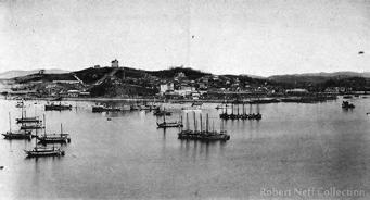
A hand-colored postcard of the port of Jemulpo, 1910-1920s, Robert Neff Collection.
hanno influenzato in prima linea la pianificazione urbana della capitale, contribuendo alla definizione delle relazioni tra il fiume e il tessuto urbano circostante8.
L’interazione tra Seoul e il suo lungofiume ha attraversato diverse fasi di trasformazione. Già negli anni Sessanta iniziò un imponente sviluppo di complessi residenziali su larga scala, seguito dall’Hangang Renaissance Project nel 2006 e dal piano per il Distretto Internazionale di Yongsan nel 2008 – quest’ultimo previsto per l’area centrale della riva settentrionale, ma rimasto inattivo9.
L’espansione urbana degli anni Settanta ha comportato un significativo spostamento della crescita edilizia verso la riva meridionale dell’Han, determinando la necessità di realizzare nuovi argini, per prevenire inondazioni, e di edificare imponenti complessi residenziali ad alta densità su entrambe le sponde, con lotti di oltre duecento metri per lato. Questo processo ha comportato una drastica riduzione dell’accessibilità pubblica al fiume. Le aree residue lungo le rive sono state destinate a funzioni commerciali, scolastiche, industriali, sportive o lasciate inutilizzate – tra queste ultime, il già citato Yongsan International District.
Negli anni Ottanta, in preparazione ai Giochi Asiatici e Olimpici, il governo metropolitano di Seoul ha promosso una serie di interventi volti al miglioramento della qualità ambientale del fiume, basati sul Piano Generale di Sviluppo dell’Hangang. Tra le principali azioni intraprese si ricordano la
costruzione di impianti di trattamento delle acque reflue – fortemente inquinate a causa dell’intensa attività industriale – e la creazione di parchi pubblici lungo il corso d’acqua. Al contempo, sono stati però realizzati ulteriori argini in cemento e due nuove arterie stradali – la Gangbyeonbuk-ro e la Olympic-daero – che, sviluppandosi parallelamente al fiume, hanno sancito il suo definitivo isolamento, compromettendone ulteriormente l’originaria funzione di spazio vitale e culturale per la città.
La situazione si modificò nel 2006 con l’Han River Renaissance Project che pose al centro delle questioni la riqualificazione del lungofiume10. Il piano prevedeva la trasformazione delle aree industriali dismesse in spazi pubblici all’aperto e la creazione di undici parchi lungo le sponde dell’Han, riconvertendo l’area fluviale in un’infrastruttura ambientale accessibile alla cittadinanza11.
Ad oggi persistono, comunque, alcune criticità legate alla limitata accessibilità delle rive e alla necessità di sostituire gli argini in cemento armato con soluzioni ecologiche che favoriscano la biodiversità e il drenaggio naturale delle acque in caso di inondazioni. Sebbene il fiume Han costituisca un elemento centrale nella struttura urbana di Seoul e comprenda centinaia di siti di interesse storico – dalla preistoria all’epoca contemporanea – situati a breve distanza dalle sue sponde12, il suo potenziale rimane in gran parte inespresso a causa delle limitazioni sopra menzionate13.
La valorizzazione di queste aree richiede strategie mirate a superare
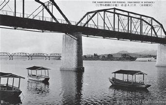
Above: small boats pass under the pedestrian bridge and the railroad bridges in the background, 1930s, Robert Neff Collection.
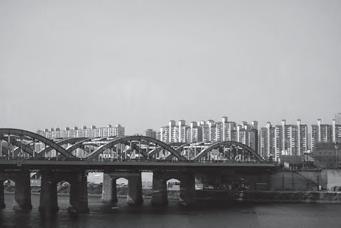
Below: Residential Development Along the Han River, 2020.
SEOUL. A GLIMPSE FROM THE HAN RIVER
When Seoul was founded 600 years ago, it embodied an ideal urban landscape that followed the natural flows of mountain ranges, rivers, and winds. Seoul has always been an ecologically planned city: it is shielded from the cold winter winds by Bugaksan and Bukhansan mountains in the north; it faces an open space towards the south; and is traversed by a river that facilitates the flow of cool breezes during the summers.
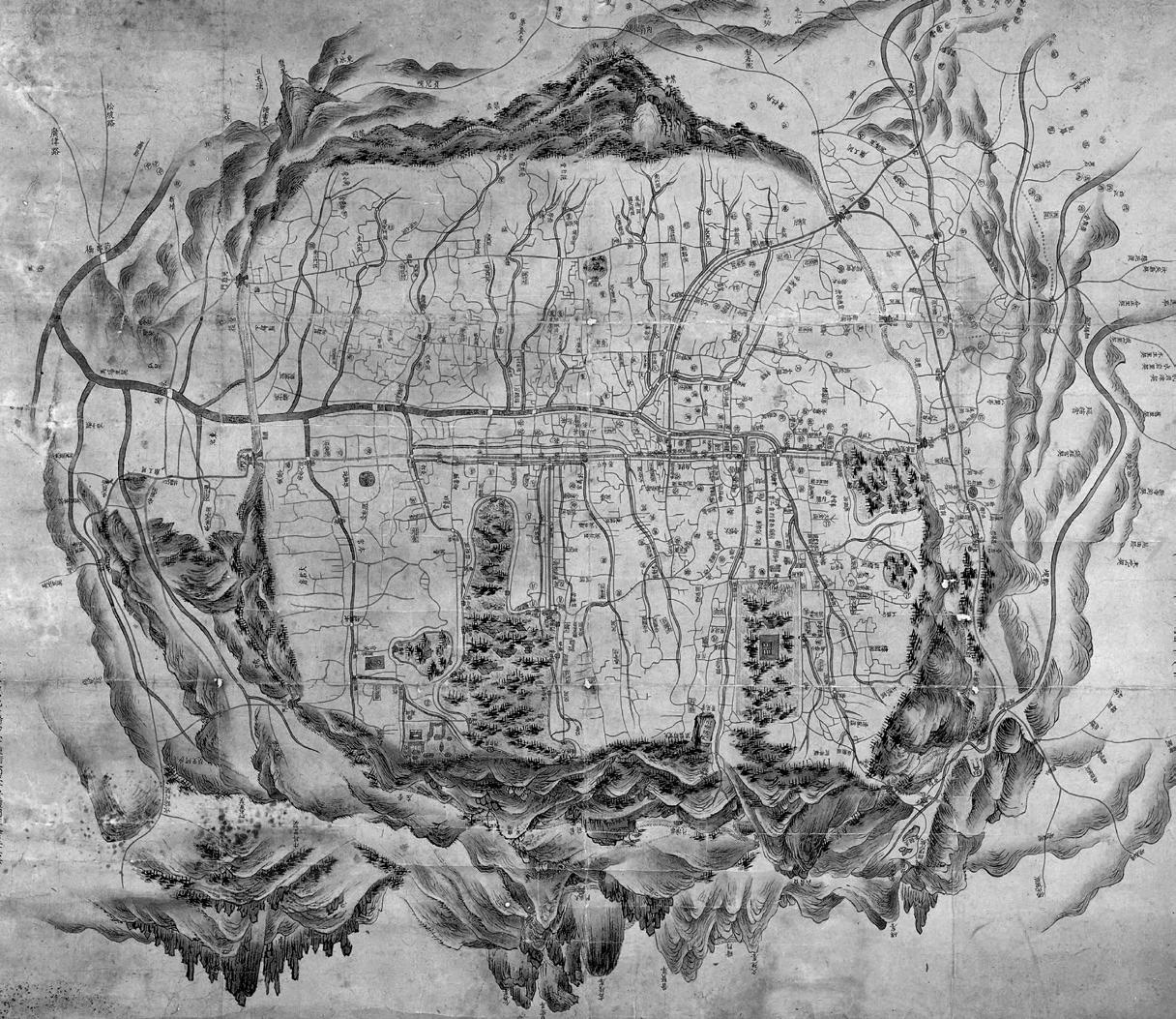
Left: Doseong dae jido (Great map of the Capital, Seoul) Late 18th century, Seoul Museum of History.
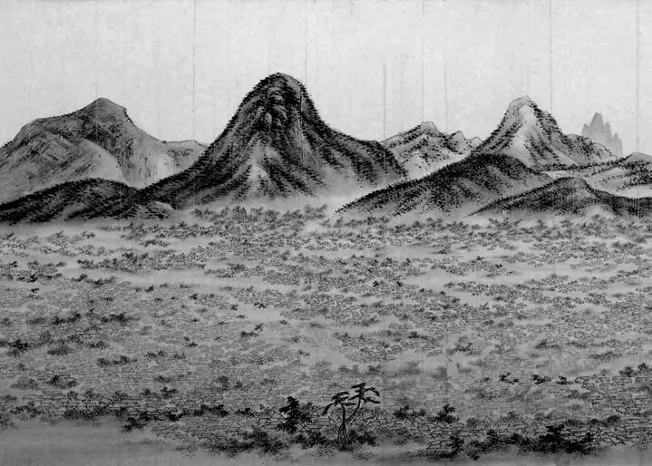
Above: the painting depicts the northwest area of the capital city viewed from Mt. Naksan in the east. The city is comfortably nestled in a basin with mountains rising high in the north. Hanyang (Gyeong seong do) Joseon Dynasty, National Museum of Korea.
The decline of this archetype – coinciding with the massive demolition of inhabited bridges for health reasons as well as new urban planning strategies during the 18th century – is almost antithetically countered by its rise in an idealized form in paintings and illusory projects, becoming both a tool for critical reading and a means for urban imagination.
Such visions are understood, in this sense, as the anticipation of a possible future through the definition
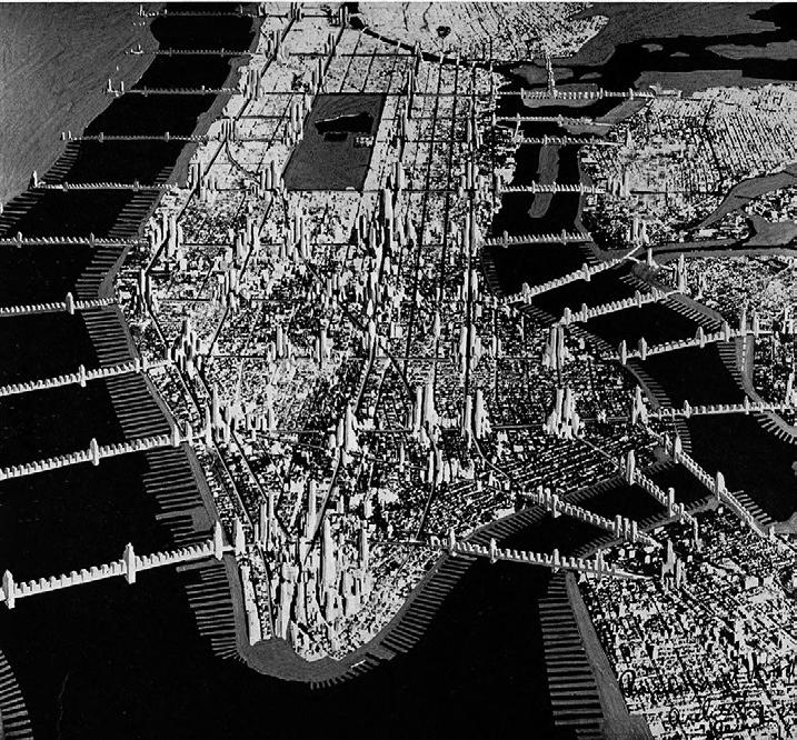
of a spatial and social model, pushing the limits of urban design to critically grasp the development threads. The comparison between the representations of the inhabited bridges of Île de la Cité in early 18th-century Paris and the vision of Manhattan 1950, connected by ‘suspended bridges laden with apartment houses’4 presented by Raymond Hood in the 1930s, proposes understanding the ambiguity of the bridge as an opportunity to investigate a body-system both through historical testimony and the
4. ‘The bridges of Hood are like drawbridges surrounding a fortress. They mark the entrances to Manhattan. […] A hermetic Manhattan, a Manhattan without exits.’ Rem Koolhaas, Delirious New York. A Retroactive Manifesto for Manhattan, The Monacelli Press, London, 1978.
Una risposta speculativa alla crescente necessità di densificazione che proponeva di sfruttare spazi prima “inabitabili”.
Al declino di tale archetipo –coincidente con la massiccia demolizione di ponti abitati per ragioni di salubrità oltre che per nuove strategie di pianificazione urbana nel corso del Settecento – corrisponde quasi per antitesi la sua ascesa in forma idealizzata nelle pitture e nei progetti illusori, facendosi strumento di lettura critica e al contempo di
immaginazione urbana. Tali visioni sono intese, in questo contesto, come l’anticipazione di un futuro possibile attraverso la definizione di un modello spaziale e sociale, portandosi al limite dell’indagine sul progetto urbano per coglierne criticamente le trame di sviluppo.
L’accostamento tra la rappresentazione dei ponti abitati dell’île de la Cité della Parigi di inizio Settecento e la visione di Manhattan 1950 collegata da “ponti sospesi carichi di case per appartamenti”4
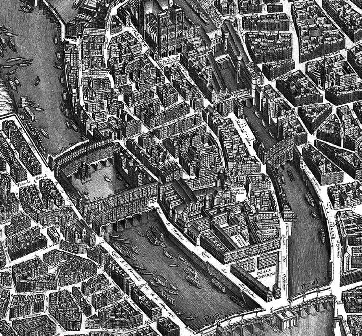
Previous page: Louis Bretez, L’île de la Cité and its bridges on Turgot’s map, 1739.
This page: Raymond Hood, Manhattan 1950, 1930.
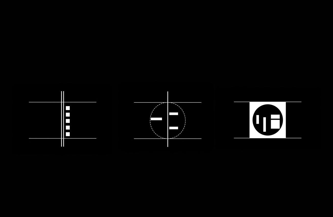
SIX SCENARIOS
1 | Tower and Linear bridge
2 | Circular bridge
3 | Fabric circular bridge
Among the activities of the research conducted, the architectural project becomes a tool for experimentation through which themes and techniques are investigated. In this context, both conceptual and practical activities were carried out, resulting in a project that takes shape as a research work.
An experimental spectrum of six different scenarios was developed for the project area assigned by the Seoul Biennale program in order to explore the operational field and derive conceptualizations and qualitative
measurements regarding the themes and figures at play. Therefore, the six trans-projectual elaborations virtually explore the theme of the inhabited bridge within the urban scenario of the contemporary megalopolis. The articulation of this theme in the six different proposals allowed working with theoretical tools and contents of design, using the project as both a cognitive and operational tool. The final result is thus the outcome of a process that can be verified through the interpretative models adopted in its generative process.
Tra le operazioni della ricerca condotta, il progetto di architettura diviene strumento di sperimentazione attraverso il quale investigare temi e tecniche. In questo quadro, si è condotta indistintamente un’attività sia concettuale sia pratica che ha prodotto un progetto che si configura come lavoro di ricerca.
Si è sviluppato uno spettro sperimentale di sei differenti scenari per l’area di progetto assegnata dal programma della Biennale di Seoul al fine di esplorare il campo operativo e trarre concettualizzazioni e misure qualitative
in ordine ai temi e alle figure in gioco. Pertanto, le sei elaborazioni trans-progettuali esplorano virtualmente il tema del ponte abitato all’interno dello scenario urbano della megalopoli contemporanea.
L’articolazione di tale tematica nelle sei differenti proposte ha consentito di lavorare su strumenti e contenuti teorici della progettazione e di usare il progetto come strumento cognitivo e operativo. Il risultato finale risulta quindi essere l’esito di un processo verificabile attraverso i modelli interpretativi adottati nel proprio processo generativo.
4 | Slab bridge
5 | Linear City and Linear bridge
6 | Fabric linear bridge
ORAZIO CARPENZANO
ALFONSO GIANCOTTI
FABIO BALDUCCI
DANIELE FREDIANI
MANIFESTO
Bridging the Megacity
In continuity with the Italian tradition on the topic of inhabiting water through architecture, the proposed project for the city of Seoul does not intend the bridge solely as a physical structure for crossing a body of water – which is usually resistant to transverse passage. Instead, it defines, in a broader sense, the possibility of going beyond the model of a compact and speculative city, with the idea of suggesting and consolidating different scenarios, inhabited through new perspectives. This entrusts the bridge with the task of reaffirming and reactivating connections: those between
MANIFESTO
Bridging the Megacity
In continuità con la tradizione italiana sul tema dell’abitare l’acqua attraverso l’architettura, il progetto proposto per la città di Seoul non intende il ponte esclusivamente come struttura fisica per l’attraversamento di uno specchio d’acqua – solitamente resistente al passaggio trasversale. Definisce invece, in senso più ampio, la possibilità di andare oltre il modello di città compatta e speculativa, con l’idea di suggerire e consolidare scenari diversi, abitati attraverso nuove prospettive. Ciò affida al ponte il compito di riaffermare e riattivare le connessioni:
PAOLO MARCOALDI
LUCA PORQUEDDU
DIANA CARTA
DOMENICO FARACO
ROBERTA MANNO
FABRIZIO MARZILLI
ANDREA PARISELLA
CLAUDIA RICCIARDI
man and nature, artifice and nature, individual and society, between old and new generations. The proposed bridge is a structure of physical and figurative connection, conceived as a large perforated beam. Eleven large structural frames – 150 meters x 150 meters each –create a permeable relationship between the city and the natural landscape. This connection is a significant and essential aspect of Seoul’s urban vision, which becomes artificial and leads towards the mountains landscape. At the same time, the beam is conceived as a sieve, it intercepts and captures large mechanical
quelle tra uomo e natura, artificio e natura, individuo e società, tra vecchie e nuove generazioni. Il ponte proposto è una struttura di connessione fisica e figurativa, concepita come una grande trave forata. Undici grandi telai strutturali – 150 metri x 150 metri ciascuno – creano un rapporto permeabile tra la città e il paesaggio naturale. Questa connessione è un aspetto significativo ed essenziale della visione urbana di Seoul, che diventa artificiale e conduce verso il paesaggio montano. Allo stesso tempo, la trave è concepita come un setaccio, intercetta
Paolo Marcoladi
The bridge serves as a locus of human connections. Constructing a bridge involves creating an artificial unity where nature had established distinctions. Beyond physically uniting, this artificial connection also assumes a metaphysical dimension, as bridges, by linking people, ideas, and cultures, become catalysts for interaction and mutual understanding. Wilhelm Dilthey envisages the entirety of human reality as a dynamic
Connections Connessioni
Il ponte è il luogo delle connessioni umane. Costruire un ponte significa creare un’unità artificiale laddove la natura aveva stabilito delle differenze. Oltre a unire fisicamente, questa connessione artificiale assume anche una dimensione metafisica, poiché i ponti, collegando persone, idee e culture, diventano catalizzatori di interazione e di comprensione reciproca. Wilhelm Dilthey concepisce l’intera realtà umana come una rete dinamica di
network of connections, in which each part retains its autonomy while contributing to the overall meaning. Dilthey emphasizes the teleological nature of human actions – how human endeavors are directed towards goals and the realization of values, distinguishing them from the mere causal connections typical of natural phenomena. ‘The human world must be understood as a dynamic connection [...] This
connessioni, in cui ciascuna parte mantiene la propria autonomia pur contribuendo al significato dell’intero. Dilthey sottolinea il carattere teleologico delle azioni umane, ossia il modo in cui le attività umane sono orientate verso scopi e realizzazioni di valori, distinguendole così dalle mere connessioni causali tipiche dei fenomeni naturali. “Il mondo umano dev’essere inteso come una connessione dinamica […] Questa connessione dinamica si distingue
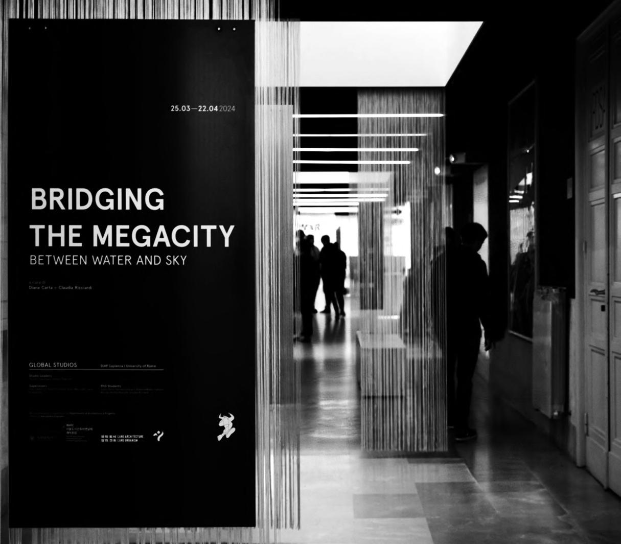
EXHIBITION IN ROME
The results of the research project coordinated by Orazio Carpenzano and Alfonso Giancotti were presented from March 25 to April 26, 2024, at the Exhibition Gallery of the Faculty of Architecture of La Sapienza University, located in Valle Giulia, Rome.
The exhibition, titled Bridging the Megacity. Between Water and Sky, was structured to illustrate the research method adopted during the different phases of the work.
The exhibition is divided into three sections, each defined by three respective light boxes placed in the Gallery, within which tripolina diaphragms are set up to guide the physical and immersive path of the entire installation.
The first section frames the theme and the international context of the Global Studios, related to the 4th Seoul Biennale, with which the Faculty of Architecture of La Sapienza engaged. It narrates, through a gallery of physical and virtual images, the reconstruction of a taxonomy illustrating the state of the art on the theme of inhabited bridges.
The second box follows, containing the Six Scenarios produced and developed by the research group to arrive, through a detailed study, at the definition of the project.
The third and final part presents the design outcome of the research, highlighting the complexity of the functional program proposed by the inhabited bridge project, where the dynamic and flexible aspect of the entire system is represented by drawings and images projected onto the panels. Throughout the entire path of the exhibition, specific panels feature fragments of the history of the city of Seoul and its intimate relationship with the natural context in which it arose in ancient times.
The journey concludes with a video of the project manifesto presented by the research group.
The exhibition was curated by Diana Carta and Claudia Ricciardi.
Gli esiti del progetto di ricerca coordinato da Orazio Carpenzano e Alfonso Giancotti sono stati presentati dal 25 marzo al 26 aprile 2024 presso la Galleria Espositiva della Facoltà di Architettura della Sapienza, nella sede di Valle Giulia, a Roma.
La mostra, intitolata Bridging the megacity. Between water and sky, è stata strutturata in modo da illustrare il metodo della ricerca adottato durante le differenti fasi del lavoro.
L’esposizione si articola in tre sezioni definite da tre rispettive campane luminose presenti nella Galleria, nelle quali sono allestiti diaframmi in tripolina che guidano il percorso fisico e immersivo dell’intera installazione.
Nella prima sezione si inquadra il tema e il contesto internazionale del Global Studios, relativo alla IV Biennale di Seoul, con la quale la Facoltà di Architettura della Sapienza si è confrontata. Viene qui narrata, attraverso una quadreria di immagini fisiche e virtuali, la ricostruzione di una tassonomia che illustra lo stato dell’arte sul tema dei ponti abitati.
Segue la seconda campana che contiene i Sei Scenari prodotti ed elaborati dal gruppo di ricerca al fine di poter giungere, attraverso uno studio di dettaglio, alla definizione del progetto.
Nella terza e ultima parte si espone l’esito progettuale della ricerca mettendo in evidenza la complessità del programma funzionale proposto dal progetto del ponte abitato, dove l’aspetto dinamico e flessibile dell’intero sistema è rappresentato da disegni e immagini proiettate sulle tavole. Lungo l’intero percorso della mostra vengono riportati, su specifici pannelli, alcuni frammenti della storia della città di Seoul e del suo intimo rapporto con il contesto naturale nel quale è sorta nei tempi più remoti. Il percorso si conclude con il video del manifesto del progetto esposto dal gruppo di ricerca.
La mostra è stata curata da Diana Carta e Claudia Ricciardi.