
Pothole Detection using IoT, Android and iOS
Shreya Ghute1 , Xavier Dsouza2 , Srushti Satardekar3Abstract - Duetovarious reasons, potholesarecreated which causes problems in day to day lives of the people. The objective of this project was to make transparency between people and provide updates about potholes in their travel route. This project was focused on getting the datafromaclouddatabase,reportedbytheuser,andthat data could be accessed through the mobile application. Projecthasachieved detectingthe potholesand reporting thepotholessuccessfullyonthedatabase.Peoplecanview the current pothole conditions and can report a pothole manuallywhichisakeyfeatureoftheapp.TheIoTdevice candetecta potholeandlocationwiththehelpofsensors like accelerometer, GPS, Arduino. The detected latitude, longitude, z axis values are sent to the cloud database for reporting. The future scope is to detect depth of the pothole to get accuracy in data and solve the problem moreefficiently.
Key Words: Accelerometer, GPS sensor, sensing, potholes,detection,location
1. INTRODUCTION
Potholes have always been a menace and are one of the biggestproblemswhichpeoplefaceona dailybasiswhile they travel. There is presently no such system to track potholes on the road in India [1]. Our approach to detect potholes is using an IoT device fitted in cars. Users can also report manually through Android and iOS applications. This system can track and record the potholes in a centralized system. It displays the pothole’s progress on the map. This system will aid to reduce accidentsandfatalitiesonroadsduetopotholes
2. RELATED WORK
A. A pothole detection system was created using various Android smartphones with accelerometers. They worked withaccelerometerspresentinvarioussmartphonesusing variouspotholedetectionalgorithmstodeploythissystem [2].
B. There are various systems that use mobile sensing technology for detection of potholes. This part provides a shortexplanationaboutdifferentmechanismswhichwere implemented on various resources. There is an image recognition method which Yu and Salari proposed for
pothole detection is based on laser imaging technique, which collects the road information using algorithms like Artificialneuralnetwork[3].
C.AnothermethodbyresearchersLinandLiuusedusinga vector machinealgorithmcouldprovidehigh accuracy.[4] This has high accuracy but requires more computational power.
3. TECHNICAL REQUIREMENTS

The following technical requirements were chosen as a basisforpotholefindersystem:
1. System should be able to detect potholes along with its location while driving in a passenger car. Two-wheeler vehicles such as motorcycles and scooters are not considered.
2. System should be able to detect potholes in real time. Collection of raw data will be stored in a local SD card in the system.
3. Data will be then pushed into a cloud database, and processedandstoredintoit.
4. A smart-phone is required with Android OS or IOS to access the application for viewing the pothole.
5. An authenticated phone number is required to report throughthemobileapplication.
6. System available on mobile should be able to display potholesonitslocations.
7.Internetconnectivityforviewingdatainmobile.
4. ARCHITECTURAL DESIGN
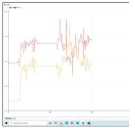
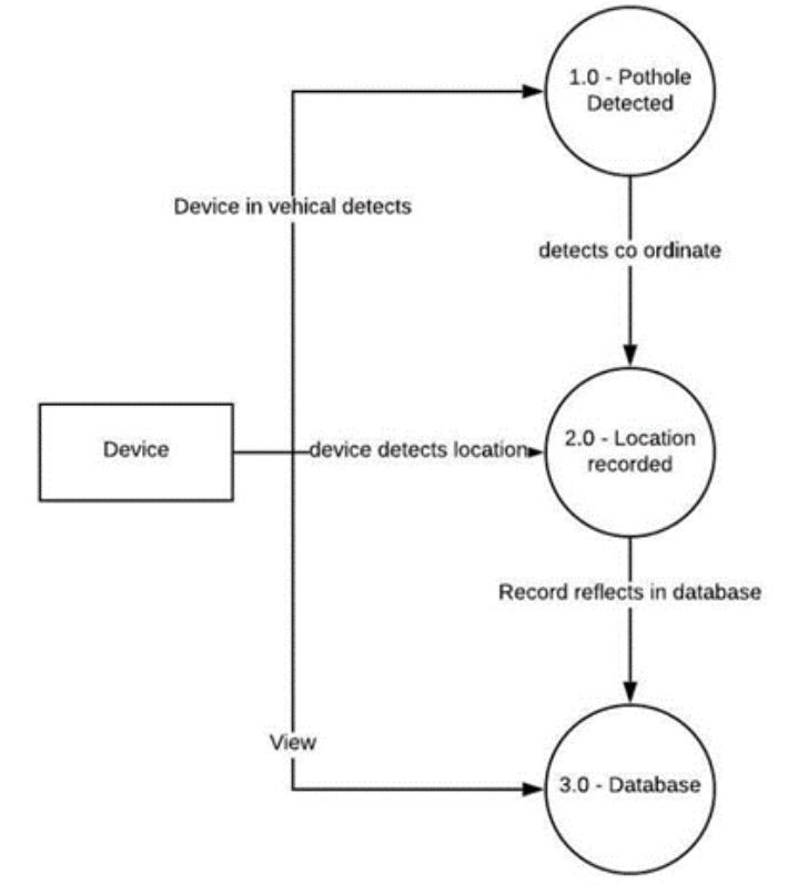
The device is based on Arduino which is connected with sensors consisting of a 3-axis accelerometer ADXL345 usedtodetectaverticalforce(pothole)usingz-axis[5]and keeping a note of device positioning using x-axis. Accelerometer was tested at different sensitivities, using at 4g and 8g no accuracy was obtained as shown in fig.1. Using16ginADXL345accuracywasobservedasshownin fig.2. A GPS module, Ublox NEO-6M GPS [6] is used to recordthelocationofthepothole.
GPS sensor positioning is at 2.5m with starting time 27 sec.Whenapotholeisdetected,thealgorithmwillcapture the location of the pothole. It records the latitude and longitude along with the vertical force on the z-axis. This data will be pushed in a cloud database to display on a GUI.ButfirstitisstoredlocallyonthedeviceinaMicroSD cardasdatamightbelostwhilebeingtransferredintothe databasethroughaWi-Fimodule

After storing locally a Wi-Fi module in the device will transfer data through the internet into a cloud database. In the database, the algorithm will check the data and no recurringdatawillbeadded.Thisdataisthenfetchedinto Mobileusingtheinternet.
The algorithm will detect the pothole and its location and record the information in the database as shown in diagramfig.3.
Onlyauthenticateduserswill beabletoaccessthemobile application.Userswillrequiretoregisterinordertologin into the app as shown in fig.4. After login, users can view potholes on map as shown in fig.5. Users can also report potholesmanuallyasshownFig.6.

TheSystemarchitecturediagramisasshowninfig.4.7.It gives the structure of the system. Data will be collected fromDeviceandsenttoaclouddatabaseandthenfetched into a mobile application where it will be displayed on a GUI.

5. RESULTS
This section explains the results and experiments on the approachesofpotholedetection. Thisresultconsidersthe data based on the sensors and data reported by the users IoTdeviceusingvarioussensors.
A. IoT device using various sensors. The IoT device consists of sensors which assist the car to detect and reportapothole.TheIoTdeviceiswellfittedinsidethecar allowingittoberigid.
The device contains an accelerometer, GPS Sensor, SD card.
B. Application using Android and IoS. The application allowsuserstoreportandviewthepotholelocationusing a cloud database. Users can report data and view the progress of the pothole. As shown in the fig. 6. After the pothole is reported, the database will show the status of the pothole. The database updates the status of the pothole when the pothole is reported, currently in progressorcompleted.
6. CONCLUSION AND FUTURE WORK
This paper describes algorithm for finding pothole and using the data, providing information to people. People can use their smartphones to track the potholes in their route.


The future work includes detection of the size of the pothole to get more accurate data and use it to solve the issueseasily.
ACKNOWLEDGEMENT
This project was supported by Prof. Prasad Padalkar, We would like to thank him for helping and guiding us throughouttheproject.
REFERENCES
[1]MumbaiMirrorArticle[Online].Available:
https://mumbaimirror.indiatimes.com/mumbai/other /photos-roads-full-of- potholes-across-mumbai- enragecommuters/articleshow/70460342.cms
[2] Artis Mednis, Girts Strazdins, Reinholds Zviedris, Georgijs Kanonirs, Leo Selavo. (06 June 2014). Real Time Pothole Detection using Android Smartphones with Accelerometers.[Online] Available https://www.researchgate.net/publication/22425315
4_Real_Time_Pothole_Detection_Using_Android_Smartpho nes_with_Accelerometers
[3] X. Yu and E. Salari, “Pavement pothole detection and severity measurement using laser imaging,” in Proceedings of the IEEE International Conference on Electro/Information Technology (EIT ’11), pp. 1–5, Mankato,Minn,USA,May2011.
[4] J. Lin and Y. Liu, “Potholes detection based on SVM in the pavement distress image,” in Proceedings of the 9th International Symposium on Distributed Computing and Applications to Business, Engineering and Science (DCABES’10),pp.544–547,HongKong,August2010.
[5] Accelerometer, (1 March 2019) W3C Process Document[Online].
Available : https://www.w3.org/TR/accelerometer/#accelerometerz
[6]GPS[Online]Available:https://www.electroschematics.c om/neo-6m-gps-module/