Framing Statement
Overview & Purpose
Existing Conditions
Proposed Plan
Recommendations
References


Framing Statement
Overview & Purpose
Existing Conditions
Proposed Plan
Recommendations
References
Growing up with family members who have contributed to urban planning, civil engineering, and real estate development, I have naturally cultivated a passion for becoming an urban planner, designer, and analyst. As an aspiring professional in the city planning field, my goal is to create inclusive environments where groups with different values and socio-economic backgrounds can come together to benefit and preserve their communities, while being mindful of the environment they live in. I am dedicated to addressing the negative impacts of urban consolidation on human and environmental well-being and building the knowledge necessary to pursue environmental planning focused on public spaces and streets.
Starting my Master of City Planning (MCP) with an Urban Design Concentration at the University of Pennsylvania has allowed me to explore the interdisciplinary reach of my interests, particularly in streets, public infrastructure, and multi-modal planning and design, with a special focus on bike facilities. In this document, I have summarized a GIS spatial analysis and site planning project analyzing the constraints of current bike infrastructures in Philadelphia and proposing a new comprehensive bike infrastructure master plan for 2035 to develop more equitable, accessible and safe bike connections in the city of Philadelphia.
Bike infrastructures promote cycling as a sustainable transportation mode, mitigate traffic congestion, reduce pollution, and enhance cyclist safety, encouraging more people to choose biking for commuting and recreation. However, despite the growing interest in measuring the safety of bike lanes, Bicycle Level of Traffic Stress (BLTS), and the analysis of bike route choices, there remains a limitation in the current research regarding where bike infrastructures actually exist in urban spaces in Philadelphia, how they are distributed across different neighborhoods reflecting socio-economic and ecological conditions, and what type of design elements is applied on the bike lane.
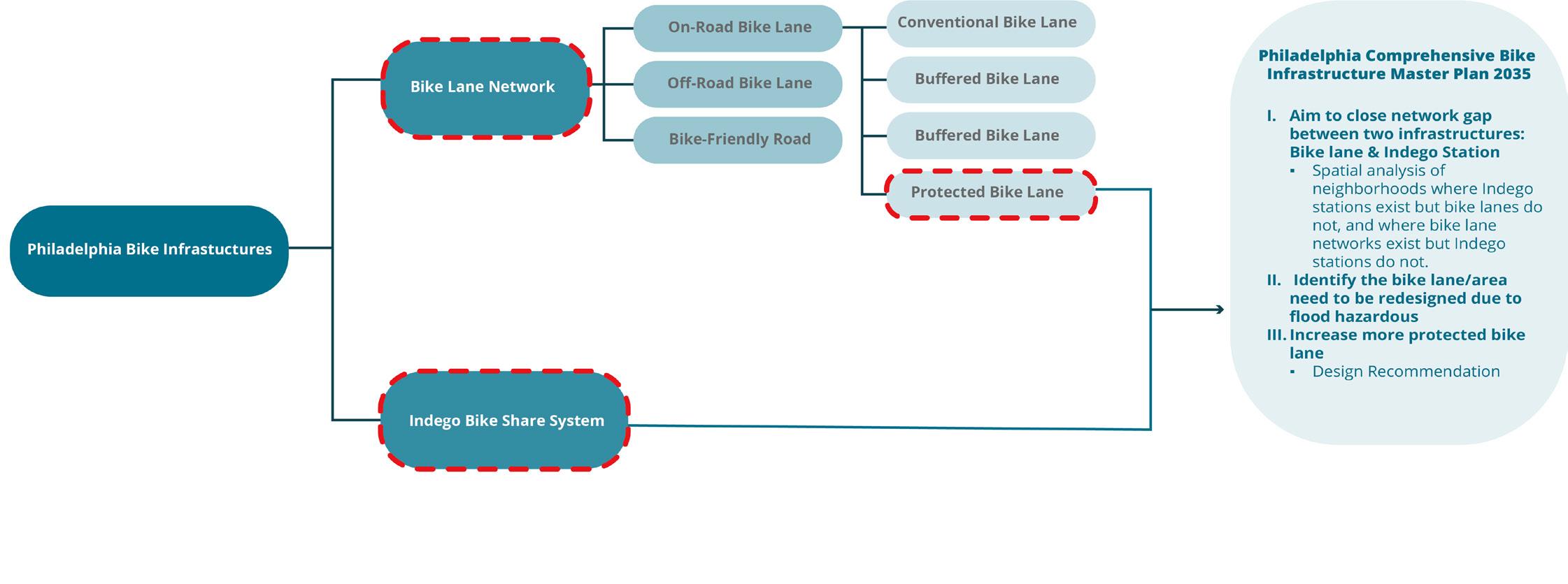
The master plan focuses on analyzing the relationship between current bike infrastructure in Philadelphia, including the bike lane network and the Indego bike share system. The objective is to bridge the network gap between these two systems by implementing more bike lanes around Indego stations and adding Indego stations in neighborhoods with bike lanes but no stations. Additionally, the proposal identifies areas that require bike lane redesign due to flood hazards by 2035. Focusing on the city government’s commitment to constructing more protected bike lanes, the proposal also contains feasible design recommendations that can be applied to the city with different phases, from buffer lanes to protected bike lanes. Therefore, the proposal identifies the neighborhoods that need more bike infrastructures or redesign of facilities and suggests guidelines and analysis for each category. Ultimately, these initiatives will improve the equal distribution of bike infrastructure, encourage safe bike lane design, and thereby promote cycling as a safe and accessible mode of transportation in Philadelphia.
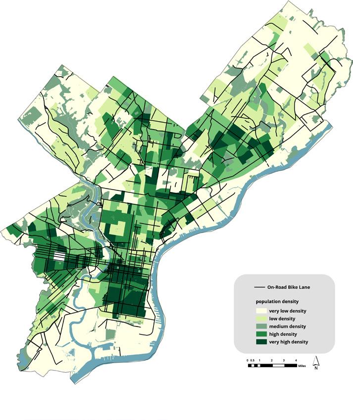
Philadelphia, one of the country’s most bike-friendly cities, boasts an expanding bike lane network and public bike share stations, ensuring safe and efficient cycling. The city has been actively developing its bike lane network with a mix of on-road, off-road (trail), and bike-friendly roads (streets without any bike facilities but where cyclists can bike safely) to connect neighborhoods, parks, and key destinations such as Center City, University City, Schuylkill River, and Delaware River. Additionally, the city’s bike-share program, Indego, launched in 2015, offers substantial ridership through convenient short-term rentals at numerous strategically placed docking stations for commuters, residents, and visitors. As a result, as of 2022, 17,000 workers use bikes for commuting among the 739,072 workers in the city, indicating a 33% increase in bike commuters from 2012 to 2022. This steady increase in bike commuters reflects the city’s successful efforts to expand bike lanes and the widespread Indego bike share program, promoting cycling as a viable and attractive mode of transportation.
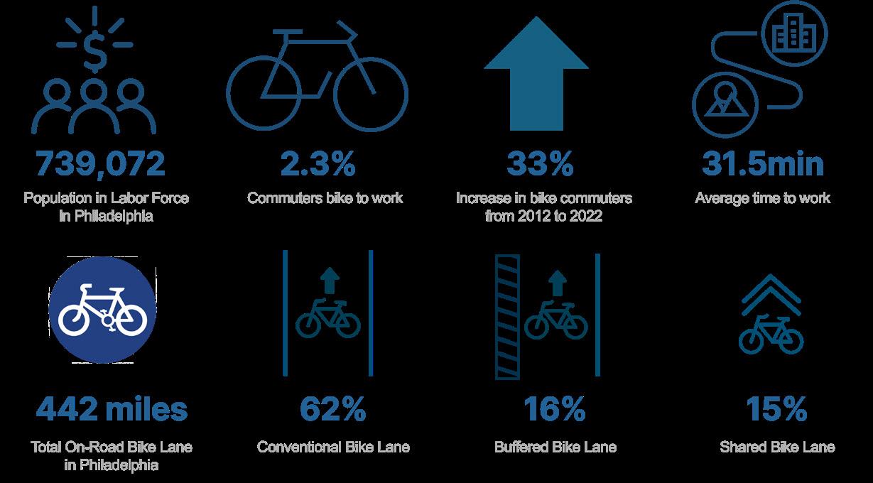
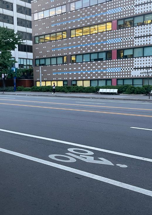
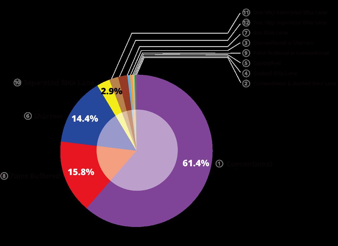
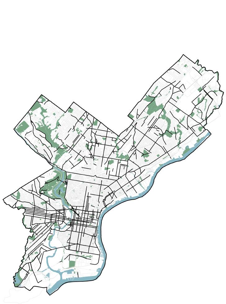
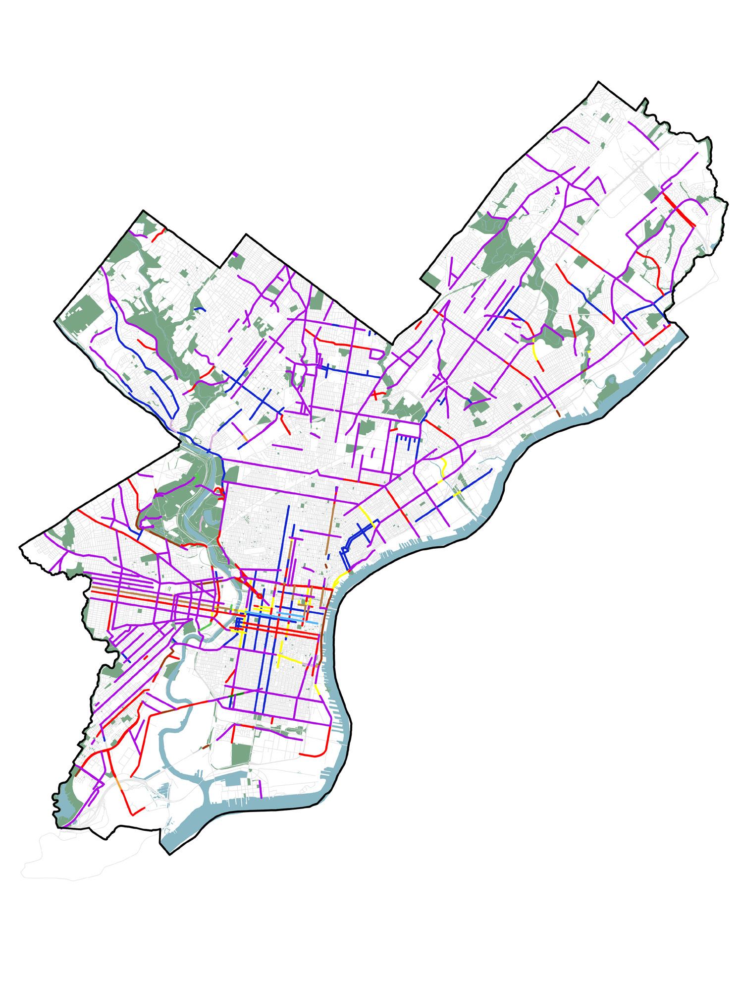
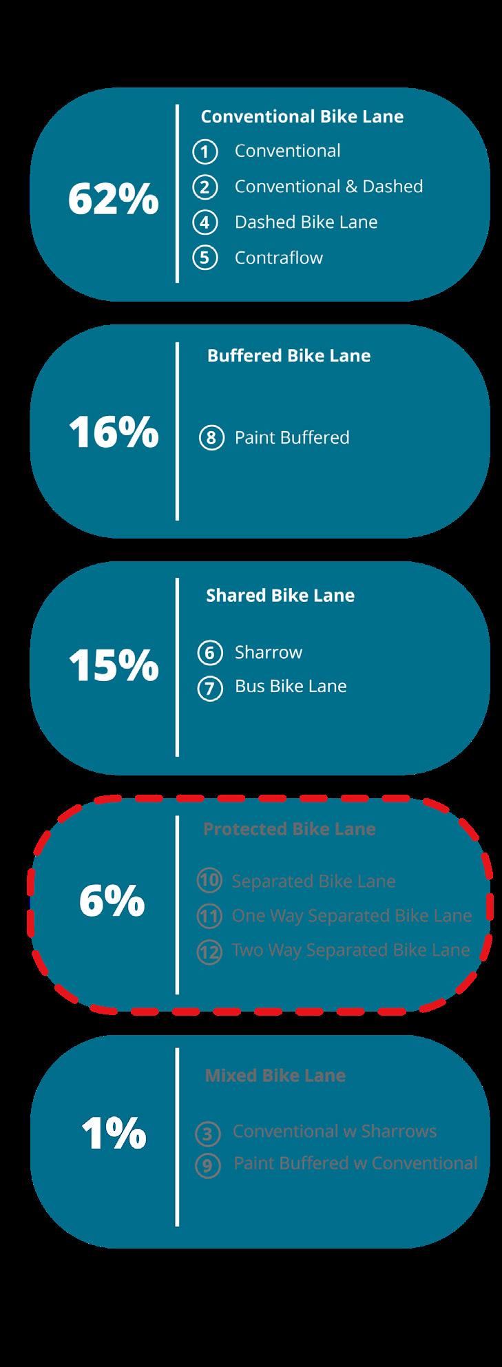
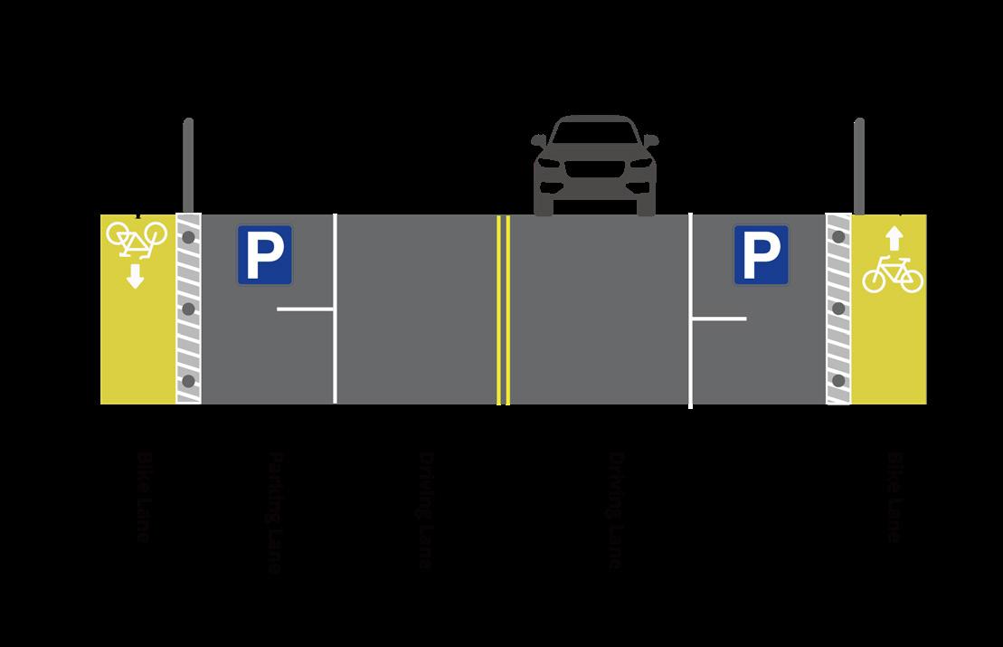
Philadelphia has made significant strides in developing its on-road bike lane network, having constructed approximately 442 miles of lanes by 2023, with primary bike typologies including 17.8 miles of painted buffer lanes, 9.8 miles of protected bike lanes, and 0.8 miles of sharrows. Figure 5 illustrates twelve on-road bike lane typologies, showcasing the city’s reliance on existing conventional lanes and the recent construction of buffer lanes. Figure 10 delineates the five primary lane groups in the urban area, highlighting a shift towards prioritizing protected lanes: conventional (62%), buffered (16%), shared (15%), protected (6%), and mixed bike lanes (1%). The city’s recent bike master plan for 2021, proposed by the Managing Director’s Office of Transportation, Infrastructure, and Sustainability, underscores this shift, emphasizing not only the distinction between off-road and on-road lanes but also a commitment to expanding protected bike lanes. This focus aligns with data from the 2023 Vision Zero Annual Report, which revealed that areas with separated bike lanes experienced 17% fewer total injury crashes and saw a doubling in the number of bike riders, indicating the effectiveness and importance of investing in protected infrastructure for cyclist safety and mobility. Expanding protected bike lanes is emphasized for their potential to reduce crash rates among motor vehicle drivers, cyclists, and pedestrians, particularly at mid-block locations where injuries tend to be most severe, but also to provide a more comfortable experience for less-skilled riders while improving access
to various destinations such as schools, jobs, major commercial districts, and essential services. With the city’s commitment to expanding on-road bike lanes, particularly by implementing more protected bike lanes for safety purposes, there is a need for additional installations of on-road bike lanes to close the gap between other bike infrastructure and increase connectivity, as well as conversions of existing lanes to protected ones to enhance safety.
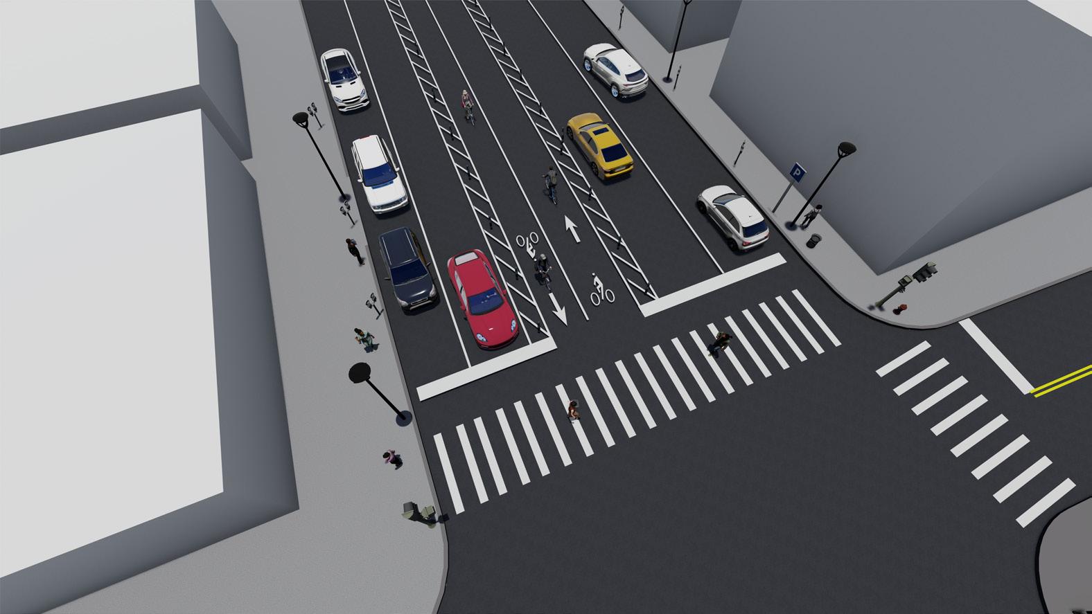
Conventional Bike Lane
Buffered Bike Lane
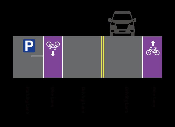
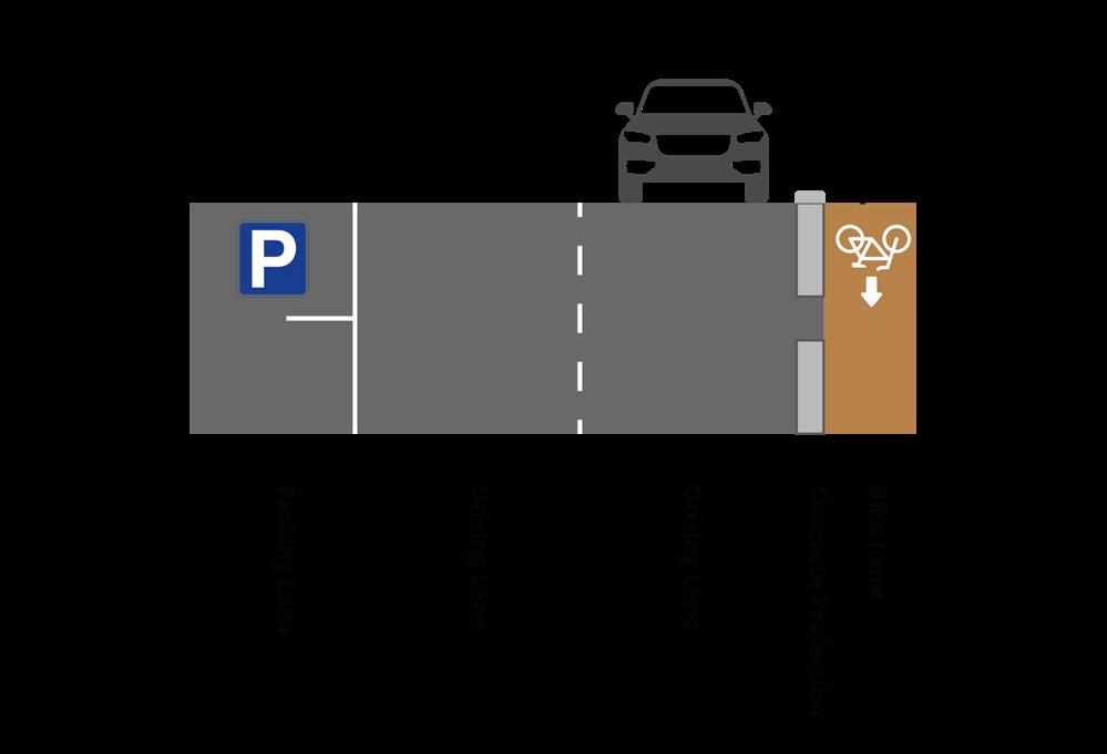
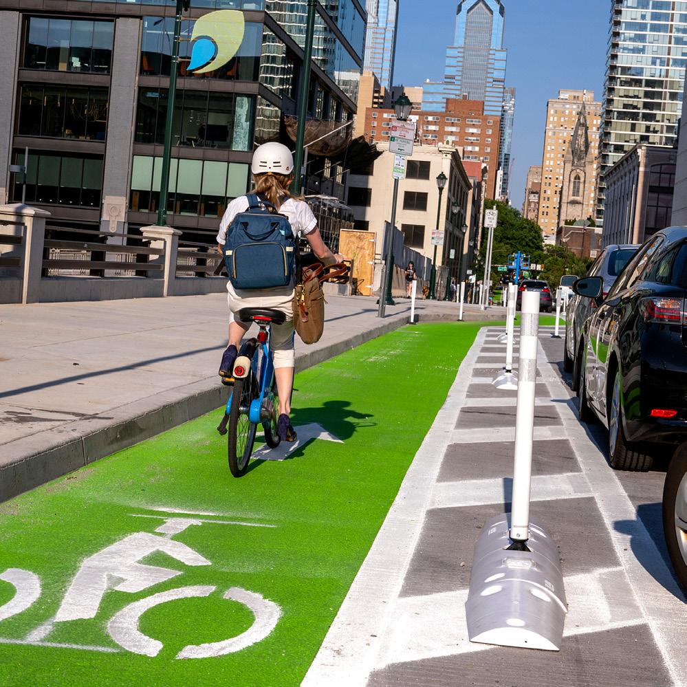
1. Parking-Separated Bike Lanes (PSBLs) Protected Bike Lane
Shared Bike Lane
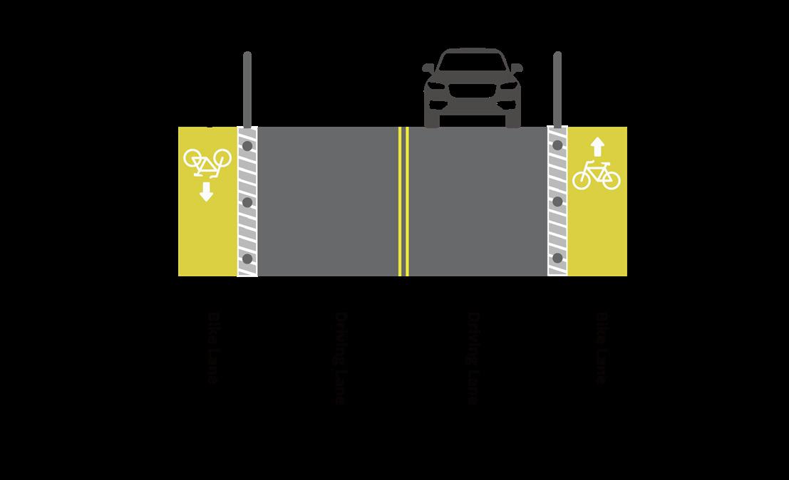
As of December 31, 2023, Philadelphia has steadily increased its network of protected bike lanes, reaching a total of 29.8 miles. The city is also actively converting conventional, buffered, and sharrow lanes into protected ones with each phase. Among the common protected bike lanes in Philadelphia are Parking Separated Bike Lanes (Fig 15), postseparated bike lanes (Fig 16), concrete protection lanes (Fig 17), and two-way raised bike lanes (Fig 18). PSBLs are on-road bikeways separated from moving motor vehicle traffic by a parking lane and a buffer area with delineator posts. Post-separated bike lanes feature a buffer lane with delineator posts separating bike lanes from driving lanes. Concrete protection lanes, featuring a 0.5-foot high protective barrier between the bike lane and vehicle road, were newly implemented mainly on American Street and will also be installed on Market Street between 2nd and 6th streets. Two-way raised bike lanes are usually implemented along wide streets with high motor vehicle volumes and/ or speeds, with a raised median as a separator, and can be primarily found on Christopher Columbus Boulevard.
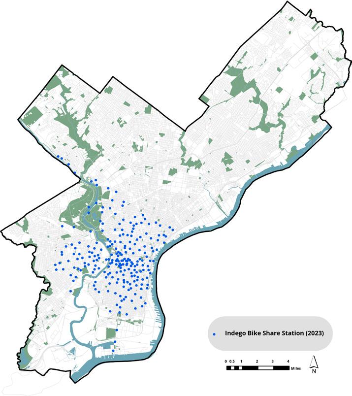
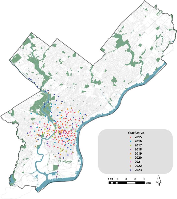
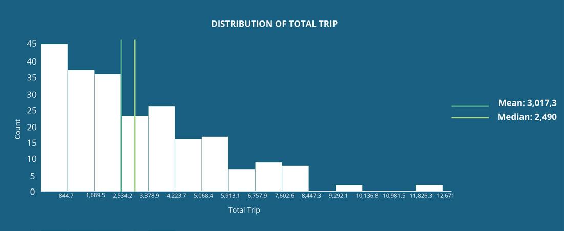
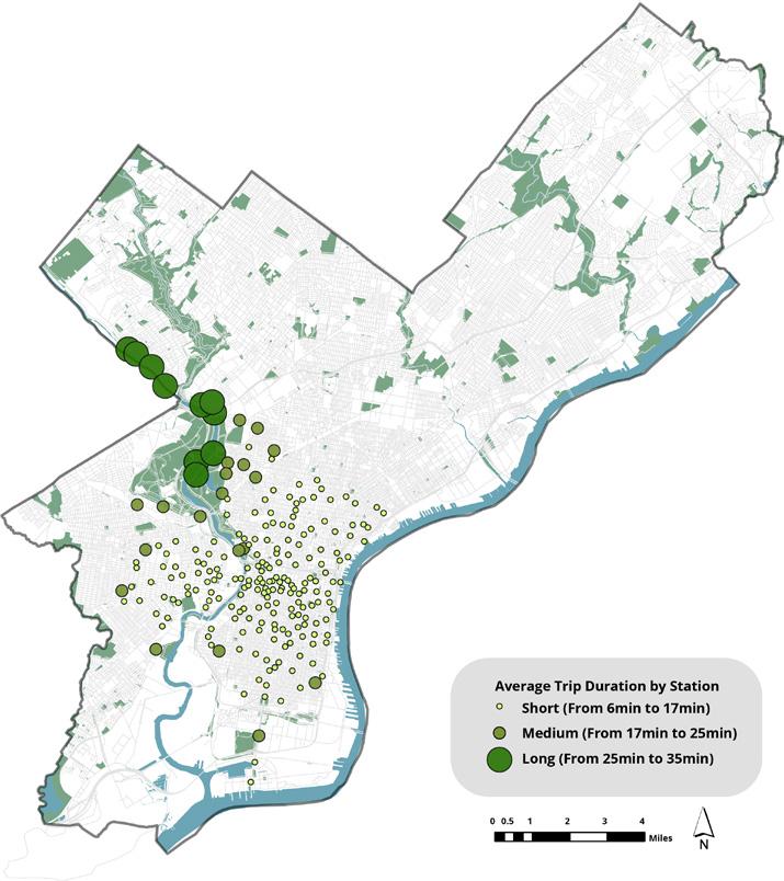
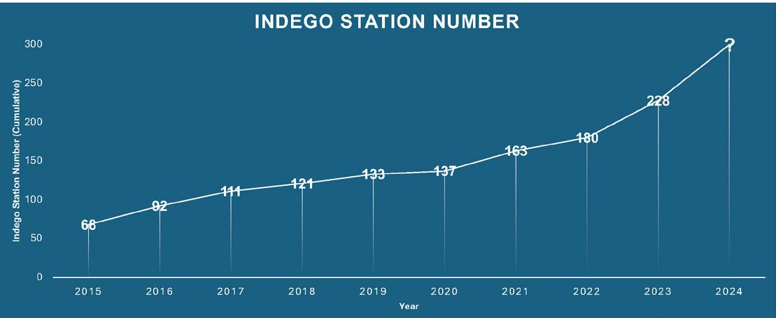
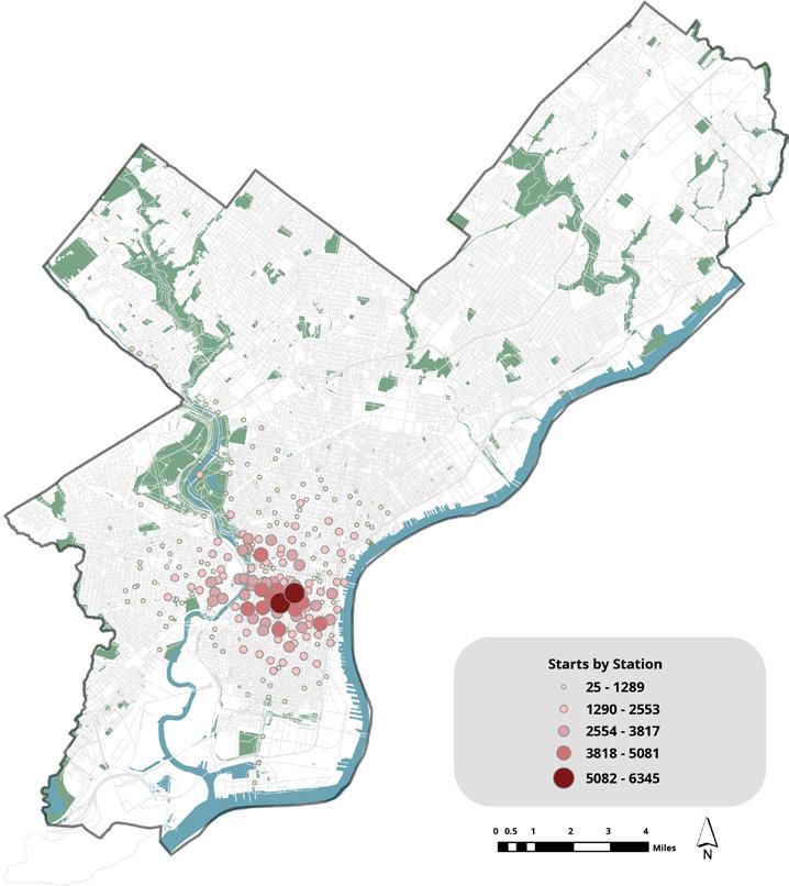
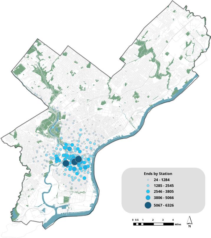
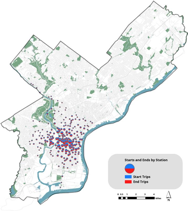
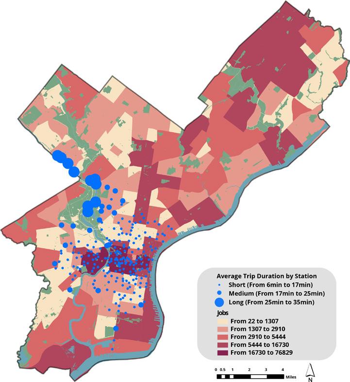
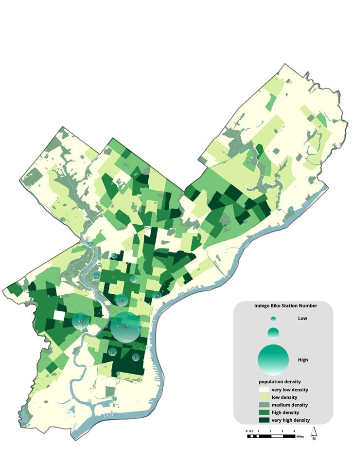
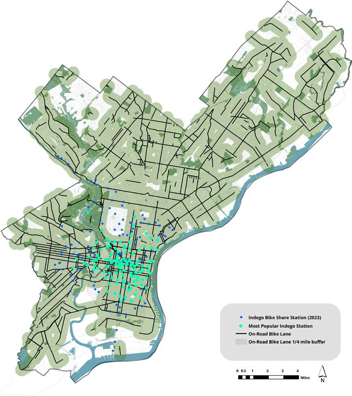
Since 2015, the development of new Indego stations has been ongoing, with a focus on expanding coverage, particularly in regions further from Center City. Despite minimal additions in 2020, likely due to the impact of COVID-19, the expansion from 2020 to 2023 aimed to broaden access to the Northern and Southern areas. An analysis of Indego stations by the number of start and end trips reveals a consistent trend: as stations move away from downtown Philadelphia, trip numbers decrease, with the highest concentrations clustered around the city center (Fig 24 & 25). However, the ratio of start-to-end trips remains balanced across all stations, indicating equitable usage throughout the network (Fig 26). Average trip duration increases as stations move away from downtown, with medium durations often observed along the Schuylkill River bank, suggesting recreational use (Fig 21). Lastly, in 2023 Q3 (July-September), the median trips per one Indego Station stood at 2,490, with approximately 50% of stations recording trips above this median (Fig 22). This data underscores the successful expansion and utilization of the Indego bike share system in Philadelphia, with higher ridership downtown and increased trip durations further out, reflecting both commuting and recreational purposes.
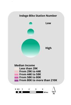
Median Income & Bike Lane
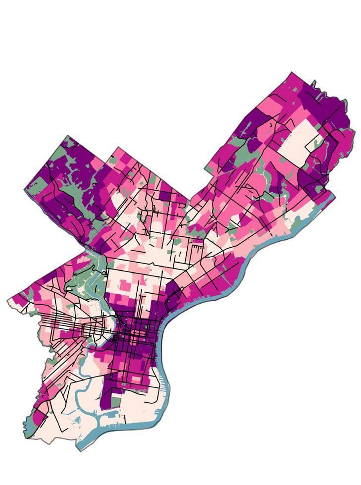
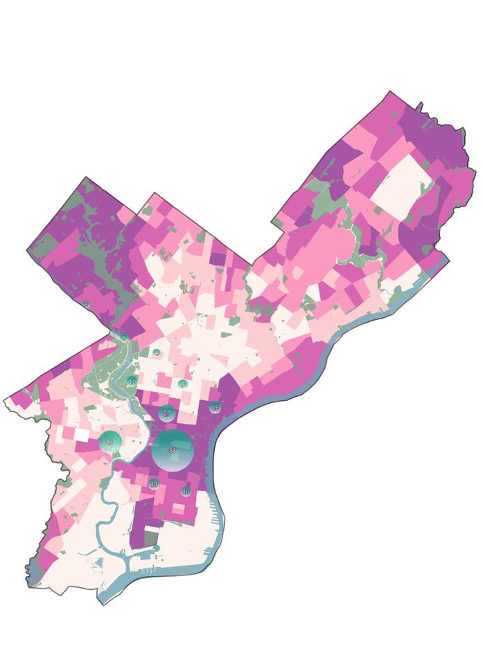
Center City and affluent neighborhoods like Rittenhouse Square, Society Hill, and Chestnut Hill typically boast higher median incomes due to factors like education levels and job opportunities. Initially, Indego stations built in 2015 were highly centralized in Center City Philadelphia, but recent expansions in 2023 have extended stations further to South Philadelphia, West Philadelphia, and North Philadelphia, aiming to extend facilities to marginalized neighborhoods. However, compared to Indego, bike lanes are evenly distributed across the Philadelphia area, irrespective of income disparities.
Center City and surrounding areas like Rittenhouse Square, Washington Square West, and University City are characterized by dense populations and diverse transportation infrastructure, including bike facilities. The distribution of bike lanes and Indego stations mirrors this pattern, concentrating in areas with high population density, transportation demand, and cycling activity, particularly in Center City. Specifically, the top three stations with the highest number of starts and ends are all in Center City: 3010 15th & Spruce, 3295 12th & Chestnut, and 3032 23rd & South Stations.
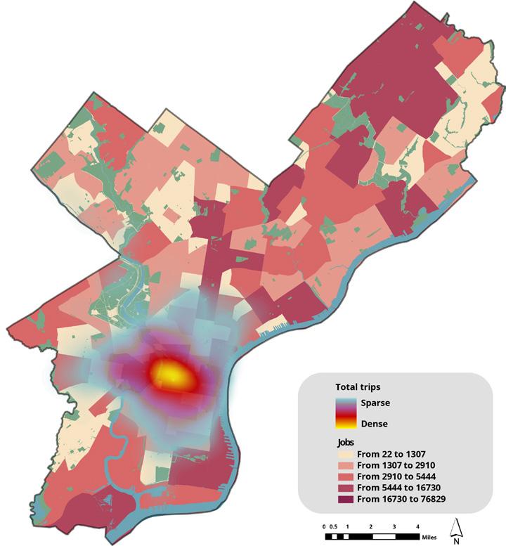
Jobs are concentrated in Center City, the Stadium District, Philadelphia International Airport, and Northeast Philadelphia Airport. As stations move away from downtown Philadelphia, start trips decrease in correlation with job numbers. Stations with the highest start trips, like Rittenhouse, University City, Logan Square, Washington Square, and Graduate Hospital, cluster indicating high job numbers around the center city. Additionally, stations like 3307 27th & Clearfield, 3281 Lindbergh & Wheeler, and 3338 54th & Cedar exhibit longer trip durations, indicating that they are further from the city center, which is the center of employment.
The proposed bike infrastructure master plan primarily analyzes the physical relationship between the bike lane network and Indego stations in Philadelphia. It studies areas with Indego stations but no bike lanes, as well as areas with bike lanes but no Indego stations, to offer a more seamless network for commuters, residents, and visitors. Additionally, the plan includes areas needing redesign based on flood risk areas. Finally, the proposal contains protected bike lane design recommendations that can maximize the safety and connectivity of the bike infrastructure network and can be applied to the Philadelphia urban area.
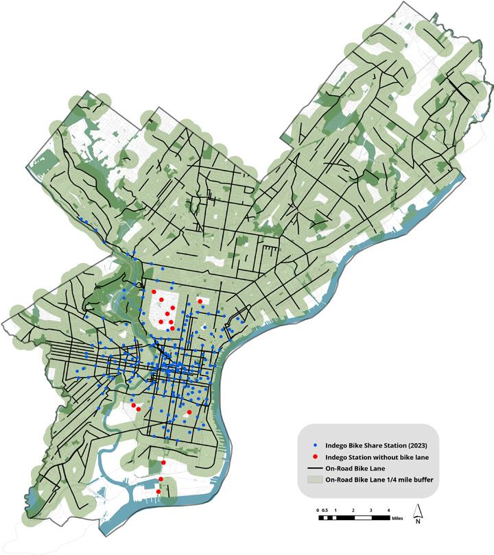
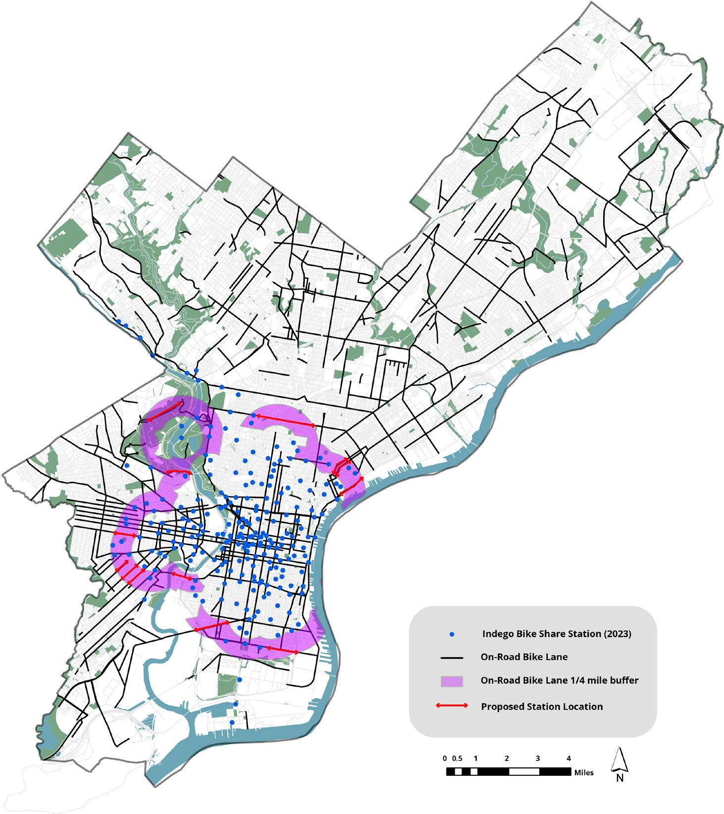
1. New bike lanes should be installed outside of the current bike lane 1/4 buffer area to maximize the connection of the infrastructure network.
2. New bike lanes should be installed in the 1-minute cutoff area of Indego stations which are not located within the bike lane 1/4 buffer area, as these stations are not receiving bike lane services.
3. Within these conditions, new bike lanes should connect surrounding commercial corridors to maximize the connection and ease of movement for residents and commuters.
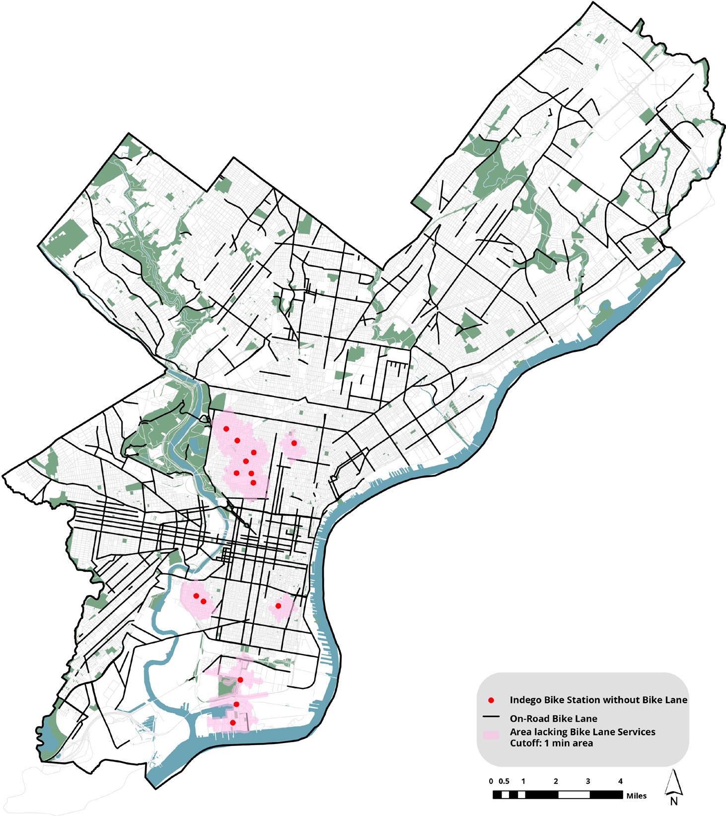
1/4 mile Bike Lane Buffer Area
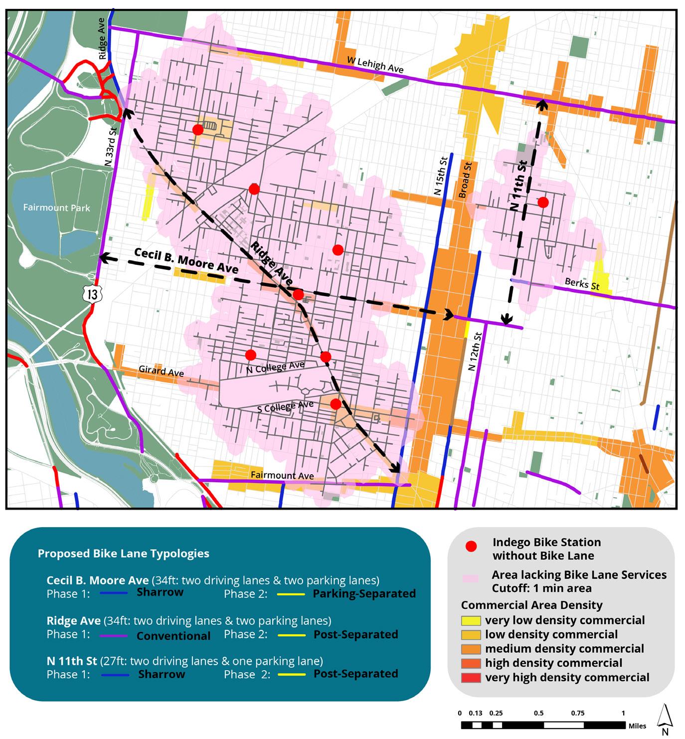
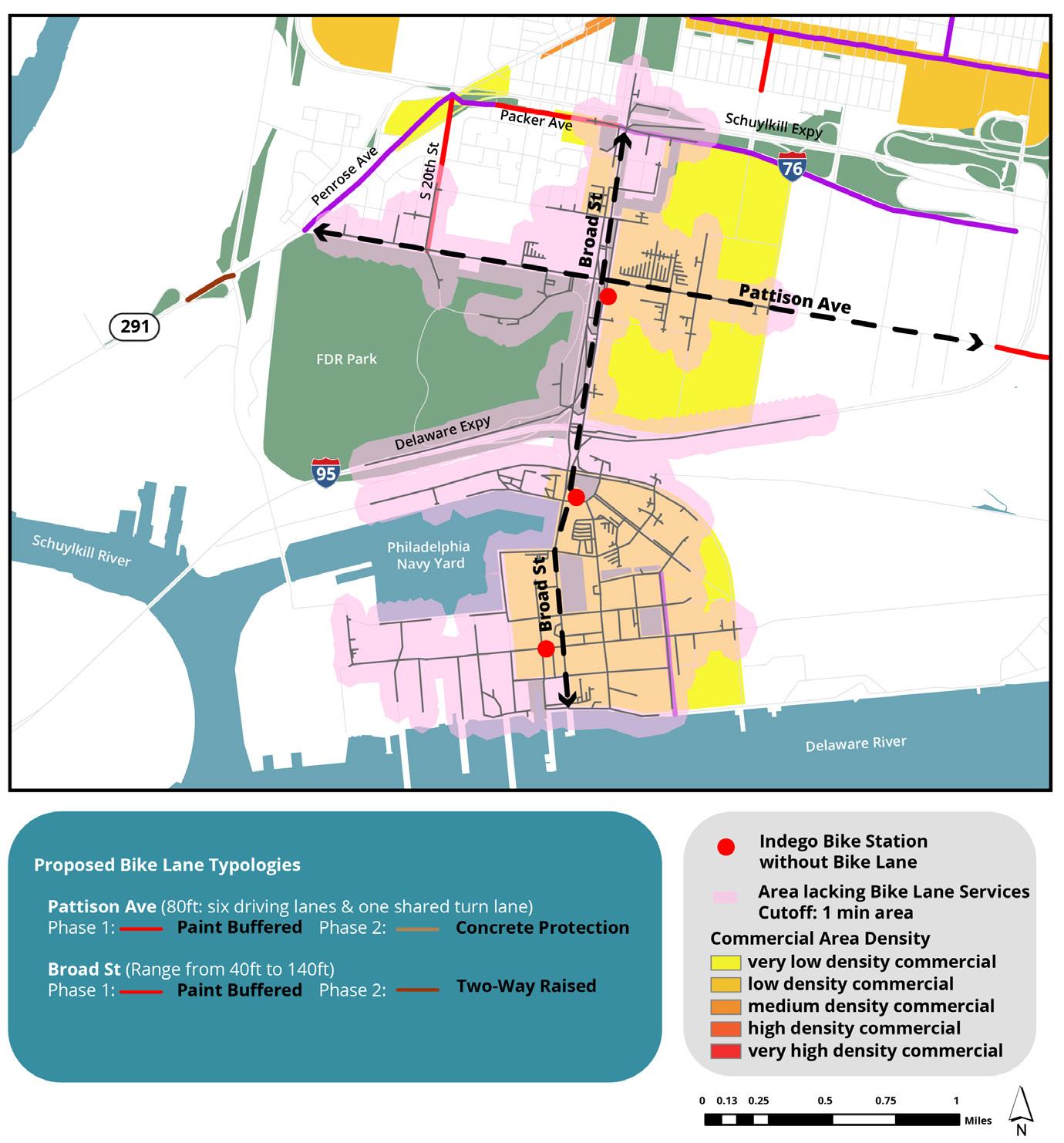
In Figure 33, a total of 14 Indego stations are not receiving bike lane service and connection, as they are situated outside the 1/4 mile buffer area of bike lanes. Based on the 15-minute city theory, the calculation of a 1-minute cutoff area, assuming bike users traveling at an average speed of 15 mph in the urban area, highlights a 1/4 mile distance. This distance represents regions where users experience difficulty biking from the station when there is no bike lane or even access to the station from the surrounding area where no bike lane exists. Thus, the pink 1-minute cutoff area indicates a lack of bike lane services around Indego stations not receiving existing bike lane connections and signifies potential areas where bike lanes need to be constructed to bridge the gap between bike share stations and the existing bike lane network. Through spatial analysis shown in Figure 34, three primary neighborhoods requiring bike lanes to close the gap between Indego stations and existing bike lanes were identified: Brewerytown, Navy Yard, and Grays Ferry.
Brewerytown, an emerging residential neighborhood attracting young professionals, features a blend of residential and commercial areas. However, eight Indego bike stations in the area lack access to bike lane networks. Among the potential roads for improvement, Ridge Ave and Cecil B. Moore Ave, with 34ft width of two driving lanes and two parking lanes, geographically intersect the town respectively from northwest to southeast and west to east, connecting key destinations and corridors mainly ranging from N15th to Broad St. Additionally, N 11th St can connect existing bike lanes in the part of Cecil B. Moore to W Lehigh Ave while crossing medium-density commercial areas. Thus, the bike lanes on these three roads can function as connecting bike lanes, offering a route from the station to major bike lanes and providing a transportation mode for commercial corridors.
Navy Yard, renowned for its commercial and recreational offerings, reveals a deficiency in bike lane connectivity near Indego stations, particularly along main roads like Pattison Ave and Broad St. These roads intersect FDR Park and the four main stadiums, boasting approximately 100 feet with over six lanes of driving traffic managed by PENNDOT. Both hold significant potential for bike lane expansion due to their current location connecting respectively west to east and center city to Navy Yard. Especially, both roads are currently classified as bike-friendly by the city of Philadelphia, where cyclists can bike, but no infrastructure is installed, causing safety concerns. Thus, both roads could be painted buffered bike lanes for the first phase but could be changed to protected bike lanes for the second phase. Pattison Ave could connect to existing lanes at Penrose Ave and S 20th St, while Broad St could provide central city to Navy Yard connectivity.
Grays Ferry, known for its mix of industrial and residential areas, benefits from its geographical position between Center City and South Philadelphia, but it shows a lack of connectivity to Center City, University City, and the Navy Yard due to insufficient bike lanes. Many of its streets, located in a one-minute cutoff area, mostly pass through residential neighborhoods and consist of a single driving lane and two parking lanes. Transforming these streets, initially with shared lane markings (sharrows), and later into parking-separated bike lanes by removing one parking lane, could promote biking as a new transportation mode for residents. This has the potential to bring economic vibrancy to the area by enhancing connectivity and accessibility to surrounding commercial corridors. Addressing the lack of connection to the main economic center in Philadelphia through improved bike infrastructure could rejuvenate the neighborhood and enhance its role within the broader city context.
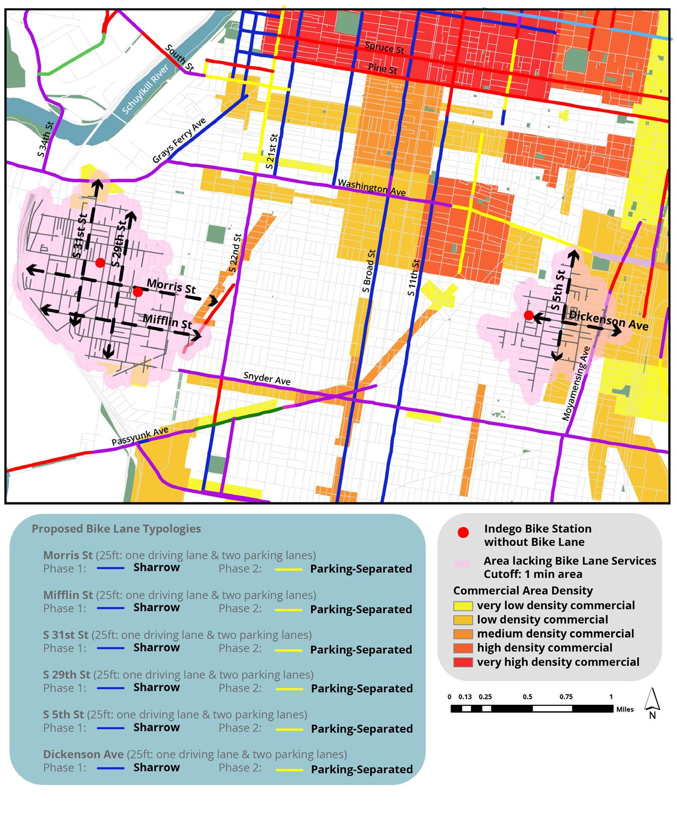
Figures 35, 36, and 37 indicate potential bike lane expansions in Philadelphia’s Northern, Central, and Southern neighborhoods, showcasing the role of new bike lanes in each neighborhood as connectors from Indego stations to the existing nearby bike lane network. Additionally, the bike lane expansions consider crossing commercial corridors or bridging between main corridors to facilitate ease of commute, movement, or travel. The proposed streets with the potential to close the gap between Indego stations and the existing bike lane network include Cecil B. Moore Ave, Ridge Ave, and N 11th St in Brewerytown; Pattison Ave and Broad St in Navy Yard; and Morrison St, Mifflin St, S 31st St, S 29th St, S 5th St, and Dickenson Ave in the Grays Ferry Area. The bike lane expansions will ensure accessible and smooth transitions for bike riders starting trips from the station or ending trips from nearby bike lanes.
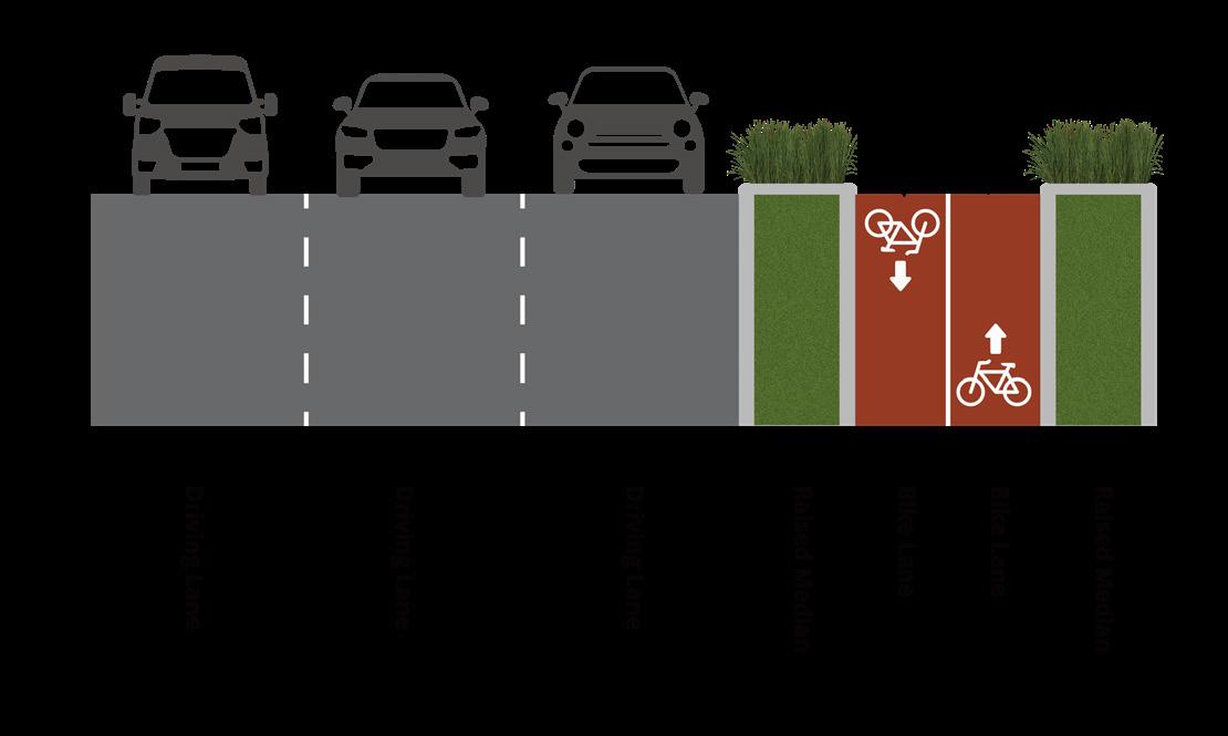
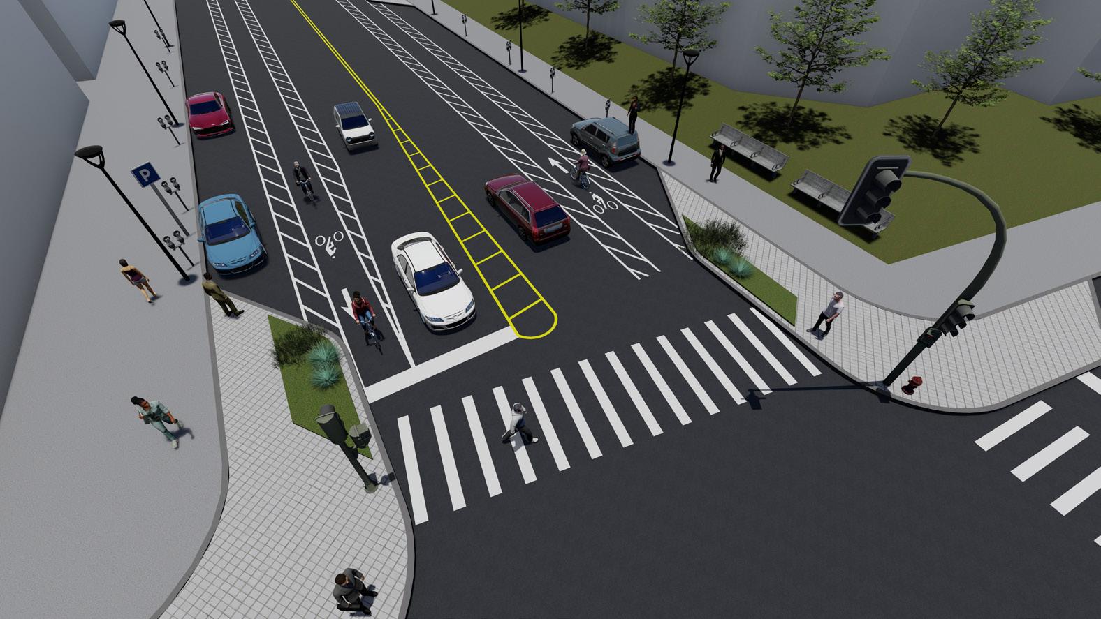
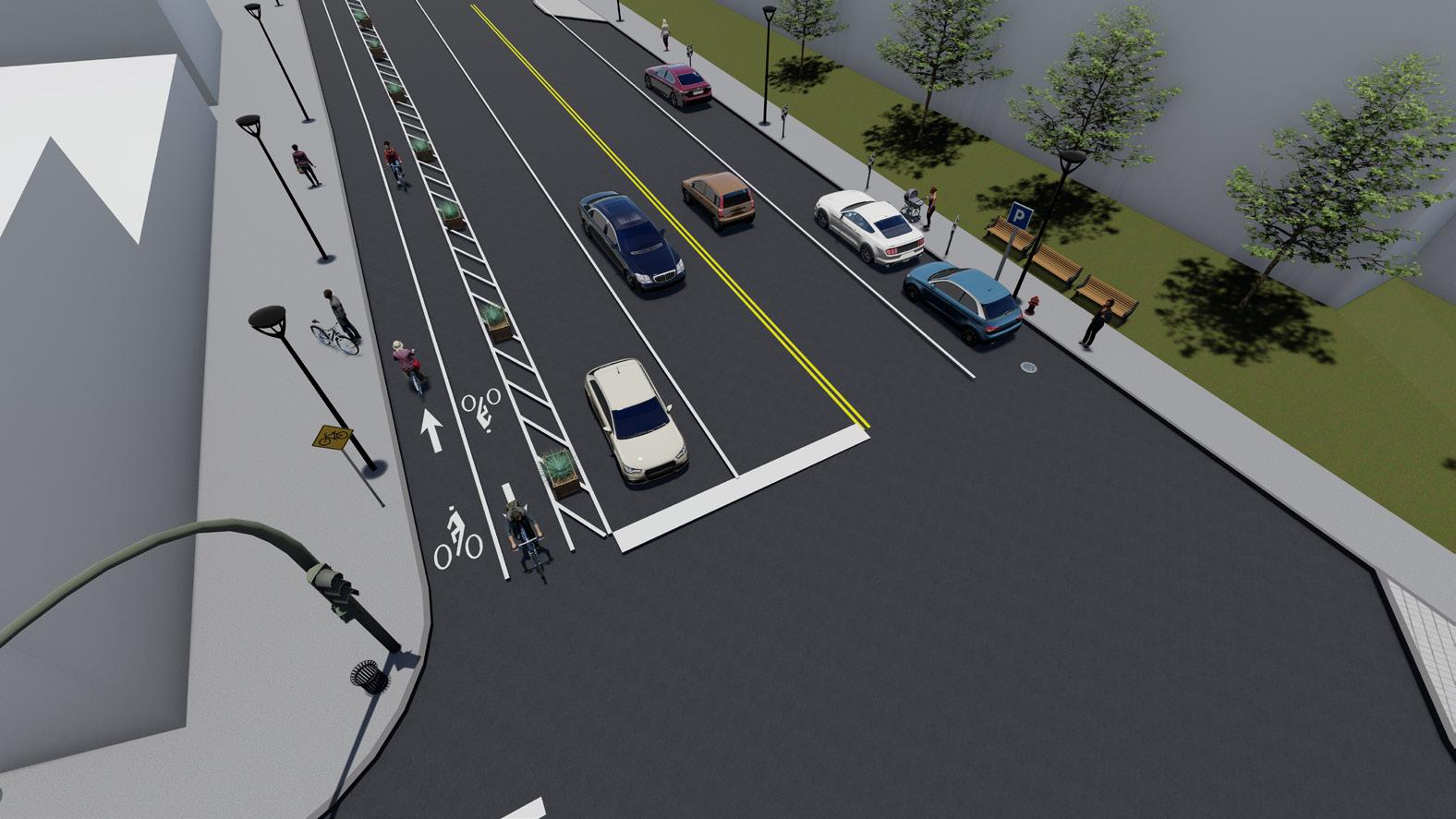
Additionally, the design implementation phase of each bike lane was distinguished based on current road conditions and street width. While adhering to the city’s commitment to expanding more protected bike lanes, the development of bike lanes faces restrictions regarding road ownership, city budget, and funding. The proposed strategies suggest painted buffer lanes, sharrows, or conventional markings for Phase 1 (2030), achievable through bike lane signage or paintwork, considering budget, funding, and timeframe constraints. For Phase 2 (2035), various types of protection installations are recommended to address safety concerns. Notably, the most common protected bike lane type in Philadelphia, PSBLs, was highly focused on throughout Phase 2 to enhance the safety of the bike lane. As the PSBLs complement existing painted buffered lanes, which still pose safety issues with the bike lane positioned between the parking lane and driving lane, the proposed approach suggests placing the bike lane near the sidewalk and utilizing the parking lane and buffered area as separation. While the majority of proposed bike lanes aim to end with PSBLs in Phase 2, Broad St and Pattison Ave at the Navy Yard are proposed as two-way raised bike lanes with raised medium, such as Christopher Columbus Boulevard
1. New Indego Stations are placed within a 1/4 mile distance of a bike network for accessibility and safety concerns.
2. New Indego Stations should be within a 1/2-1 mile distance from the most frequently used existing stations to avoid creating duplicates while also supplementing existing infrastructure to accommodate higher ridership.
3. New Indego Stations should not be installed in identical on-road bike lanes as existing Indego stations, regardless of their current usage, to avoid infrastructure surplus.
Based on the analysis of Indego bike share stations’ usage across Philadelphia in 2023 Q3 (July-September), the median of total trips is used as a benchmark instead of the mean, considering the large range and inconsistent distribution of total trips by stations. Current Indego stations with total trips above the median, totaling 115, serve as key reference points. Then, the 1/2-1 mile zone from these main 115 stations is p roposed as the optimal distance to maximize ridership and transfer efficiency. Additionally, optimal placement dictates that bike lanes and stations should be within a 1/4 distance (1-minute cycling and 5-minute walking), contributing to the concept of a 15-minute city by promoting more walkability and cycling rate but reducing dependence on cars.
1/4 mile Bike Lane Buffer Area & Popular Indego Stations
1/2-1mile Distance from Popular Indego Stations
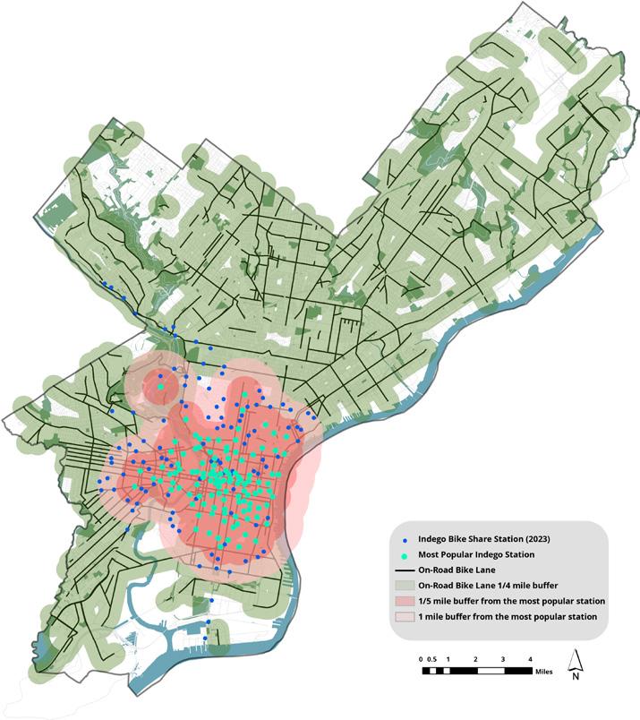
Figure 40 indicates potential expansions of Indego Stations into Philadelphia’s Northern, Western, and Southern neighborhoods, installing bike stations throughout residential heavy areas, commercial corridors, or park where there are bike lanes but lack stations for increased usage of both infrastructures. The proposed areas for future Indego station construction to bridge the gap between the bike lane network and Indego stations include W Lehigh Ave, Tulip St, Memphis St, and Delaware Ave in Fishtown; Spruce St, Passyunk Ave, Oregon Ave in South Philadelphia; Grayferry Ave, Kingsessing Ave, Springfield Ave, Florence Ave in Grays Ferry; and Chamounix Dr and Lansdowne Dr in Fairmount Park.
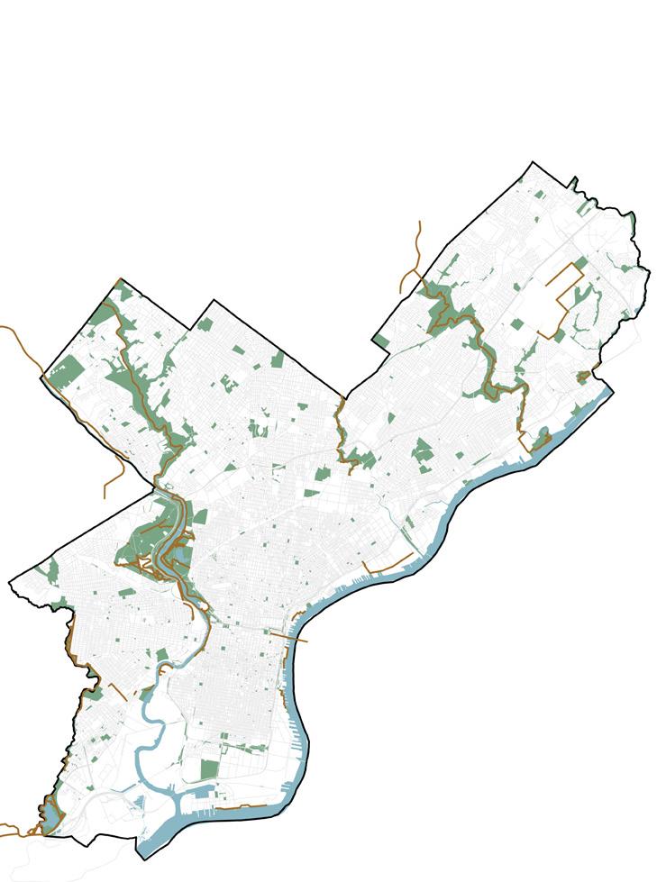
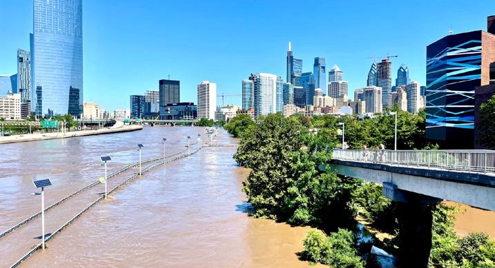
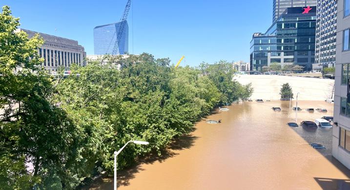
In addition to installing bike infrastructure, including bike lanes and Indego stations, in neighborhoods lacking services or connections, the proposal also involves revising existing on-road bike lanes to address vulnerability to floods and the need for redesigning bike lanes or surrounding facilities. Given the increasing flood risk and heavy rain due to climate change in the Philadelphia region and its impact along tidal rivers or flash flooding on inland roads, the studies also focus on areas where on-road bike lanes overlap with the 100year floodplain and 500-year floodplain.
1. On-road bike lanes and surrounding facilities located on a 100-year floodplain should be redesigned for safety and sustainability concerns.
2. Bike lanes planned for construction in flood-prone areas should follow flood risk-mitigating design strategies.
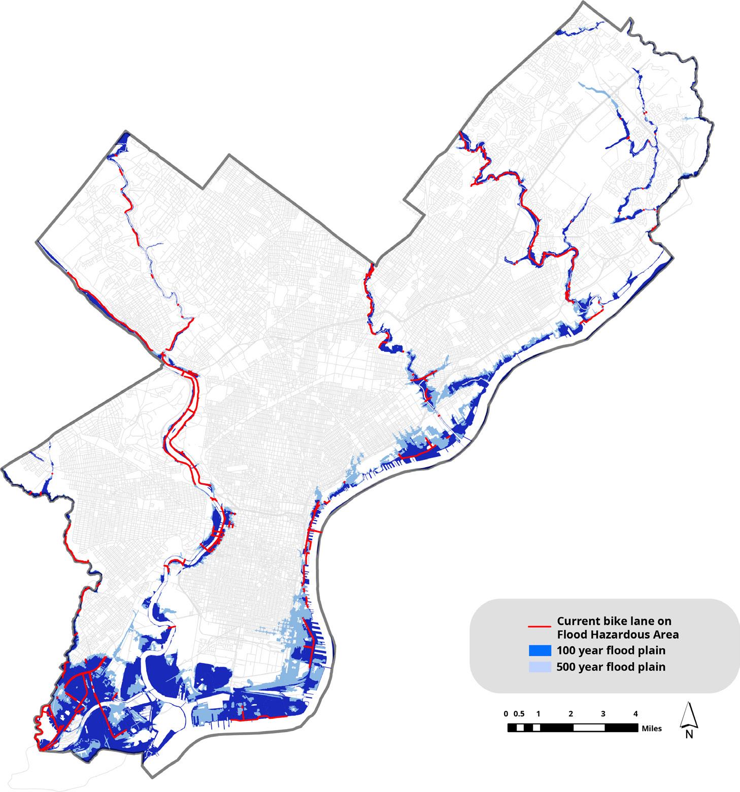
Figures 43 indicate the presence of existing bike lanes situated within the 100-year floodplain in the Philadelphia region, notably clustered around areas such as the Schuylkill River, Delaware River, Philadelphia International Airport, Tacony Creek, and Pennpack Creek. Given Philadelphia’s susceptibility to intense rainfall and flooding, implementing various flood mitigation strategies directly within or near bike lane facilities becomes crucial. These strategies encompass elevated bike lanes, permeable pavement, and green infrastructure like rain gardens and bioswales on raised medians. Elevated bike lanes provide protection from rising waters by situating lanes on elevated platforms or bridges. Permeable pavement, when combined with green infrastructure elements, allows water to permeate through, thus reducing runoff and the risk of flooding. Additionally, incorporating flexible design features such as easily removable barriers, bollards, and signage enables adaptation to changing flood conditions, ensuring cyclist safety during emergencies. By integrating these flood management strategies into bike lane design facilities, the impact of flooding on cycling infrastructure can be effectively mitigated, thereby enhancing resilience and safety for cyclists in flood-prone areas. For these strategies to be effectively implemented, city governments must commit to flood-resilient design and extend protected bike lanes. Policies should prioritize such infrastructure, offering funding and incentives to encourage its implementation. These incentives could support developers in incorporating green infrastructure into their designs or assist in the construction and maintenance of flood-resilient bike lanes. Additionally, policies can incorporate flood-resilient features into protected bike lane regulations and zoning ordinances to ensure comprehensive flood mitigation measures.

2035
Double Buffered/Separated Bike Lane (Optional: Curb Extension with Raised median or Swales)
Buffer to reduce door zone conflict
Travel Side Buffer Configuration
Parking Side Buffer Configuration
Optional: Bioswale to mitigate heavy raining/flooding
Optional: Curb Extension to enhance pedestrain safety and decrease vehicle speed
Two-Way Buffered/Separated Bike Lane (Optional: Planters)
Travel Side Buffer Configuration
Optional: Planter for separation and aesthetic elements to the streetscape
Painted Buffer for Phase 1 & Protectors (Planters, post, or concrete curb) for Phase 2
Two-way Bike Lane protecting space for bicyclists and enhancing comfort
Center Orientated buffered/Separated Bike Lane (Optional: Post, Concrete protection, or Raised Median)
Travel Side Buffer Configuration
Optional: Delineator Post for separation
Painted Buffer for Phase 1 & Protectors (Planters, post, or concrete curb) for Phase 2
Center-Oriented Bike Lane
“What targeted strategies can Philadelphia implement by 2035 to ensure equitable, safe, and sustainable access to bike infrastructure across all neighborhoods?”
Philadelphia Comprehensive Bike Infrastructure Master Plan 2035
• Develop new bike lanes near Indego stations
• Maximize protected bike lanes
• Implement new Indego stations near the bike lane network
• Redesign bike lane on flood risk area to improve safety and sustainability
Create seamless network between bike infrastructures to create connectable, equitable and safe city network (Creating 15-min city)
• Three design strategies—doublebuffered/separated bike lane, two-way buffered/separated bike lane, and center-oriented buffered/separated bike lane
In conclusion, with the city government’s commitment to boosting the bike network, the proposal contains three recommendations: constructing bike lanes near Indego stations where bike lanes do not exist, implementing Indego stations near bike lanes where none exist, and redesigning bike lanes in flood risk areas. Particularly, areas were identified where Indego stations lacked connectivity to the existing bike lane network, and vice versa, highlighting the need for strategic implementations to bridge their gap. Analysis of their physical relationship revealed key reference points for future expansions, emphasizing the importance of optimizing placement for maximum ridership and efficiency. Additionally, flood risk design strategies and policies for bike lanes located in flood-prone areas should be actively implemented by the government, as well as protected bike lanes, due to safety and environmental sustainability issues. Finally, the design recommendations guide the step and phase for a protected bike lane design implementation, indicating feasible ways of transitioning from a painted buffer bike lane to a separated lane with protectors from phase 1 to phase 2. Three proposed design strategies—double-buffered/separated bike lane, twoway buffered/separated bike lane, and center-oriented buffered/separated bike lane—can be implemented based on road conditions or each phase. The proposal places a strong emphasis on achieving equal connectivity through diverse infrastructures and integrating safety measures, thereby enhancing urban mobility throughout the suggested Philadelphia neighborhood area. Overall, the proposal aims to create a more accessible and interconnected biking infrastructure in Philadelphia, promoting sustainable transportation and enhancing the city’s livability.
Alvaro Caviedes and Miguel Figliozzi. “Modeling the Impact of Traffic Conditions and Bicycle Facilities on Cyclists’ on-Road Stress Levels.” Transportation Research Part F: Traffic Psychology and Behaviour 58 (2018): 488–99. DOI: 10.1016/j.trf.2018.06.032.
Bicycle coalition of Greater Philadelphia. “Philadelphia Releases a Bike Lane Expansion Report for 2023.” Accessed Jun 7, 2024. https://bicyclecoalition.org/philadelphia-releases-a-bike-lane-expansion-report-for-2023/
Billypenn. “Philly’s first curb-protected bike lanes are planned for Market Street in Old City.” Access May 25, 2024. https://billypenn.com/2023/05/19/curb-protected-bike-lane-philadelphia-east-market-street/
City of Philadelphia. Accessed May 20, 2024. https://www.phila.gov/
City of Philadelphia. “Philadelphia Parking Separated Bike Lane Study.” Access Jun 1, 2024. https://www.phila. gov/2022-04-01-philadelphia-parking-separated-bike-lane-study/
DVRPC Bicycle LTS & Connectivity Analysis.
Indego Bike Share. Accessed Jun 10, 2024. https://www.rideindego.com/ Loukaitou-Sideris, A., Liggett, R., Sung, H., Boudreaux, M., & Ratzkin, R. (2005). “Death on the Crosswalk: A Study of Pedestrian-Automobile Collisions in Los Angeles.” UC Berkeley: University of California Transportation Center. Retrieved from https://escholarship.org/uc/item/7pc652ws.
U.S. Census Bureau. “5-Year 2021 American Community Survey for Philadelphia, PA.”
U.S. Census Bureau. “5-Year 2012 American Community Survey for Philadelphia, PA.” Tables B08141.
U.S. Census Bureau. “5-Year 2022 American Community Survey for Philadelphia, PA.” Tables B08141.
U.S Department of Transporation Federal Highway Administration. “SEPARATED BIKE LANE PLANNING AND DESIGN GUIDE.” Accessed May 25, 2024. https://nacto.org/wp-content/uploads/2016/05/2-4_FHWA-Separated-Bike-LaneGuide-ch-5_2014.pdf