Aaron Marcavitch, Director of Economic & Community Development
Laurie Whitten, Director of Planning
Georgienna Driver, Assistant Planner
Stephen Hiney, Assistant Planner
Kristy Koistinen, Community Development
Specialist
AMERICAN PLANNING ASSOCIATION
URBAN DESIGN & PRESERVATION
DIVISION
Kris Krider, Chair*
Marianne Stuck, Chair-Elect
Hadley Peterson, Secretary/Treasurer
Marcel Acosta, Immediate Past Chair
Shannon Cilento, DPRAT Coordinator*
Nour ElZein D-PRAT Scholar*
*in person volunteer
IN-PERSON VOLUNTEERS
Peter Erwin (Group 1 Lead)
Stefan Pellegrini (Group 2 Lead)
Caitlin Palmer (Group 3 Co-Lead)
Heidi Samokar (Group 3 Co-Lead)
Keith Woodcock (Youth Engagement Lead)
Dagmar Noll
Hailey Hyun
Jacob Knowlton
Jerald Berry
Weizi Yu
VIRTUAL VOLUNTEERS
Andrea Cruz Mejia
Ashley Sukalski
Bennett Smithhart
Bhavya Iyer
Brad Wolf
Brian Foote
Bryan Leyba
Caroline Hedlund
Chris Carlberg
David Goodman
Dwight Merriam
Isa Enriquez
Ishita Ghosh
Jacqueline Vanegas
Leon Darren Harper
Maisha Tyler
Margarita Saldana
Maria Rubio
Onam Bisht
Ryan Auer
INTRODUCTION
IN-PERSON WORKSHOP
Site Visit
Open House: Stakeholder Session
Visual Preference Survey
Design Session & Presentation
YOUTH ENGAGEMENT
GROUP 1: WATERFRONT & TRANSPORTATION HUB
The information provided within this D-PRAT report is for general informational purposes only. While we try to share up-to-date and correct information, there are no representations or warranties, express or implied, about the completeness, accuracy, reliability, suitability or availability with respect to the information, suggestions, services, or related graphics contained in this report for any purpose. Any use of the methods described within this report are the individual contributor’s personal thoughts. They are not intended to be a definitive set of instructions for Enfield and do not represent the policies or positions of the American Planning Association.
“You can’t pay for heart…because their hearts are in it…because they want to make a difference…these people really cared…”
Mayor Ken Nelson Jr. March, 17, 2025
“The Ideabook will be a transformative tool that the Town of Enfield can used to lift up Thompsonville for its second act.”
Aaron Marcavitch, Director of Economic & Community Development
Marie Pyzner, Deputy Mayor – “DPRAT is a wonderful program.”
Michael Ludwick, Councilmember – “The American Planning Association…it is great to see an association that actually takes the time to put great work together pro bono.”
“Folks should really appreciate the amount of work that you…put into it…”
01 INTRODUCTION
INTRODUCTION
The Urban Design and Preservation Rapid Assistance Team (D-PRAT) is a pro-bono program supported by the American Planning Association (APA) and the Urban Design and Preservation Division within the APA. The purpose of the D-PRAT is to quickly support under-resourced communities and organizations in their efforts to collaboratively plan for the future with a focus on the urban design of the public realm and preservation. The fourth D-PRAT program began in the fall of 2024, working with the Town of Enfield, Connecticut, with a focus on the Thompsonville area.
The Town of Enfield applied for the program and identified that they were looking for technical expertise to help identify opportunities and solutions for the village of Thompsonville. Their objective was to ask the D-PRAT to provide information and guidance on the three areas in Thompsonville: the Waterfront & Transportation Hub, Main Street Corridor & Freshwater Brook, and the Historic Central Business District. This plan aims to transform these areas by creating a vibrant transit-oriented hub, encourage investment to support mixed-use development, enhance public space with streetscape redesign, and build a resilient town core. The Enfield D-PRAT was assembled as a collection of volunteer urban designers and historic preservation experts after a call for interest among Division membership. The
Enfield D-PRAT program consists of a virtual technical assistance team that supported project work before and during the in-person Design Workshop. The Urban Design and Preservation Division funded volunteers to travel and be in-person on October 21st and 22nd, 2024. Together three groups collaborated to develop this Ideabook.
BACKGROUND & DESCRIPTION
The Town of Enfield, Connecticut, is a suburb located in Hartford County, 18 miles north of Hartford, Connecticut, and 8 miles south
of Springfield, Massachusetts. Enfield was named and incorporated by the Colony of Massachusetts in 1683 and annexed to Connecticut in 1749. The town is 33.8 square miles with a current population of approximately 45,246.
The Town of Enfield is seeking planning assistance for re-envisioning the Thompsonville village between the Thompsonville Transit Center/Connecticut River to the west, and Enfield Street. This village was once home to the Bigelow-
Town of Enfield
Thompsonville
Map of Enfield, CT
Hartford Carpet Mill, which closed in the 1970s. Thompsonville is one of the more compact neighborhoods in Connecticut. After this closure, the Town embarked on a process of urban redevelopment, which largely failed. Since then, the Town has struggled to redevelop this area. The mill was converted to apartment housing, but the surrounding neighborhood has not received the same redevelopment interest. This disinvestment has led to blight, infrastructure failure, and a lack of community pride. It has also resulted in a higher frequency of health issues (asthma/heroin use).
Many studies have been done for Thompsonville over the last thirty years, with limited success in implementation. With the CTrail Hartford Line passenger rail station in design phase (construction proposed to start in late 2025), and at least two new significant developments proposed for the area (coupled with a major “dead mall” redevelopment project adjacent to the area) there seems to be new momentum. The specific goal of this project is to develop a vision that will allow the community to see the potential for the area and build some community pride. Proposed interventions are focused on the ability of it to be implemented quickly. Throughout this Ideabook the groups examined strategies to make the area accessible and inviting, sought placemaking strategies, and created visuals to emphasize simple modifications that can be implemented quickly.
Youth Engagement
In addition to the geographic and sitespecific projects, the team worked with local high school(s) on a PhotoVoice project and develop cognitive maps of the community. Students used an aerial map to mark areas they like, where they hang out, areas to be improved, and areas to avoid.
GOALS & PROJECT STATEMENTS
Group 1: Waterfront & Transportation Hub
Group 1 focuses on transforming the Connecticut Riverfront and proposed Thompsonville Transit Center into a vibrant, connected transit-oriented hub which encourages private investment. Key initiatives include enhancing the boat launch; reimagining area connectivity; developing a “river view” pier; creating public amenities; mixed-use development opportunities and
Map of Thompsonville Group Study Areas
integrating multi-modal transportation options. The goal is to create a dynamic and activated space where transit and tourism meets health and community needs.
Group 2: Main Street Corridor & Freshwater Brook
Efforts in this area aim to revitalize Main Street and reconnect the hidden scenic areas along Freshwater Brook. The plan includes reviewing options to implement portions of a previously shelved bike access project, upgrading streetscaping for a cohesive look (wayfinding, street sign design), public arts, complete streets, and improving access to Freshwater Brook and the Mill Pond. This will create a more inviting and connected environment for residents and visitors alike.
Group 3: Historic Central Business District
The focus in this area is on rejuvenating the downtown core by looking at infill redevelopment and building preservation opportunities, creating public amenities, wayfinding, improving storefronts, and upgrading parking. A prior study indicated that the area was over parked, but future developments (Transit Center, new housing) may change that analysis. This area has the potential for community amenities and an improved visitor experience.
On-ground team during the 2-day Workshop
02 IN-PERSON WORKSHOP
IN-PERSON WORKSHOP
SITE VISIT/STAKEHOLDER SESSIONS/VISUAL PREFERENCE SURVEY/DESIGN
SESSION/COMMUNITY PRESENTATION
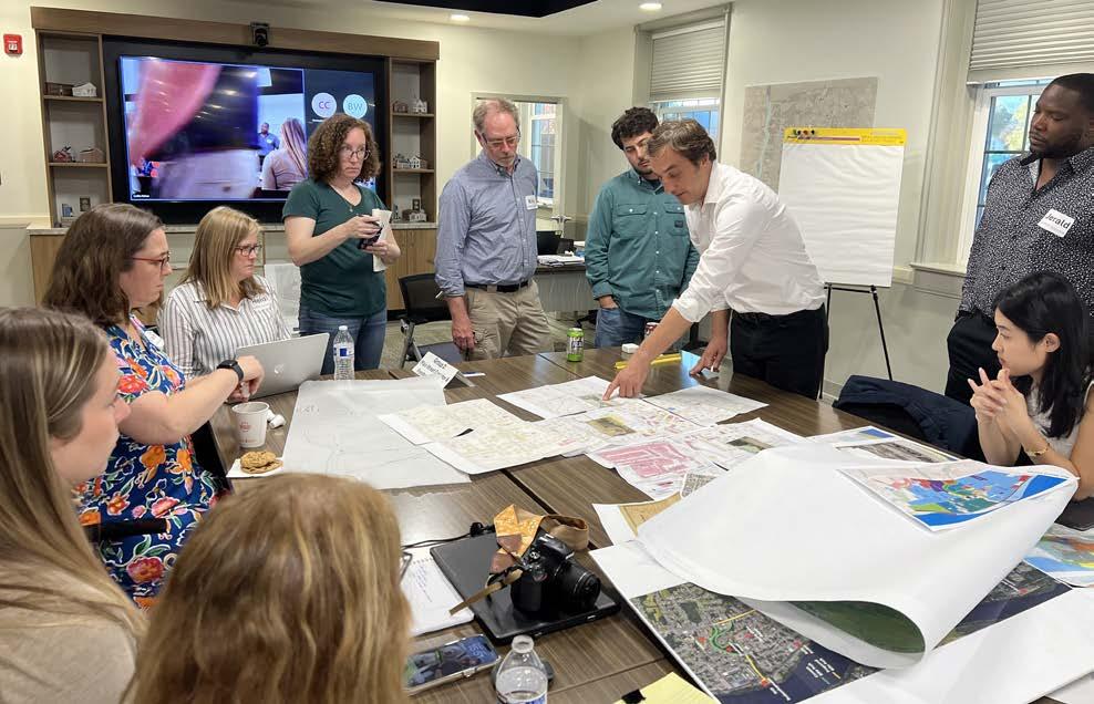
The Design workshop was hosted in Enfield Town Hall for two days on October 21st & 22nd, 2024 where both local and D-PRAT professionals explored Thompsonville, met with stakeholders, surveyed residents, and proposed ideas to residents.
On the first day of the workshop, teams were introduced to the site with a walking tour guided by Aaron Marcavitch through all three proposed areas, visiting key locations that allowed each group to identify critical points of interest. Then each team began to analyze their initial observations, and prepare for the Open House. Stakeholders then joined the workshop at Town Hall, interacted with each team’s station, gave valuable local input, and engaged with the visual preference survey. Teams continued drawing until the Open House where local residents were welcomed to add additional input, present their visions about each site, and engaged with the interactive stations.
On the second day of the workshop, teams debriefed on their findings from Day 1, revisited each of their sites with a focus on site issues, started to refine their design recommendations and ideas for a town presentation. Additional stakeholders and residents were also welcomed by teams to add input. Teams finalized their initial recommendations and findings and presented them to the town. Community
members then reacted to the proposals and giving input and expressing optimism for the future vision of Thompsonville.
Youth Engagement was integrated throughout the on-the-ground portion of the program, both at the open workshops and at youth centered locations within Thompsonville. See page 20 for the youth engagement summary.
GROUP 1:
Waterfront & Transportation Hub
GROUP 2:
Main Street Corridor & Freshwater Brook
GROUP 3:
Historical Central Business District
Top to bottom: Looking north toward remaining bridge piers, N. Main underpass and entrance to public boat launch.
Top to bottom: View north of Bigelow Commons, Freshwater Brook, group shot on the walking tour.
Top to bottom: View from N. Main toward Pearl St., from Asnuntuck Street, & east corner of Alden & Church St.
STAKEHOLDER SESSIONS
+ OPEN HOUSE
On Day 1, teams interacted with locals in Stakeholder Sessions to gain a better understanding of residents’ perspectives on each section of Thompsonville, and identified critical issues that are faced at each site.
On Day 2, teams held an Open House to gather more input from community members and continue to ideate about the sites.
Each team also had the opportunity to engage with the community through interactive stations designed to elicit local recommendations on site-specific inquiries.
GROUP 1
HOW WOULD YOU LIKE TO CONNECT WITH THE RIVER?
GROUP 2
WHAT TYPES OF ACTIVITIES WOULD YOU LIKE TO SEE MORE OF IN THE MAIN ST. CORRIDOR?
HOUSING THAT REFLECTS THE ORIGINAL MIXED USE AND ARCH. CHARACTER OF THOMPSONVILLE BIKE ACCESS
HOMELESS & MORE LIGHTS
CONNECT TO WINDSOR LOCKS RIVERSIDE CANAL TRAIL
UNUSED HOUSES + EMPTY NEIGHBORHOOD
PERMANENT HOMELESS SHELTER
GROUP 3
PLACE OF IMPRESSION IN THOMPSONVILLE (HISTORIC BUILDING, PUBLIC SPACE, SHOP, ETC...)
HOW FAR ARE YOU WILLING TO WALK FROM YOUR CAR TO YOUR DESTINATION? (IN THOMPSONVILLE) LED SIGN FARMERS MARKET SMALL BUSINESSES CROWD XX MIXED USE SCHOOL FISH AND CHIPS SHOWCASE
WALKING & BIKE PATHS
ALONG RIVER
PATH ALONG THE EAST SIDE OF THE RIVER BOARDWALK / PAVILION WITH TABLES
BOAT LAUNCHDEFINE LEDGE AREA PICK UP LITTER LANDSCAPING LIGHTING
DEFINED PATHWAYS
DOG PARK & COFFEE SHOP
PROJECTS SHOULD BE CONTIGUOUS IN NATURE, RATHER SPOT ZONED
WHERE IS THE HEART OF THE TOWN?
WHAT WOULD ATTRACT YOU TO THOMPSONVILLE? (BUSINESS, SERVICE, EVENT/ PROGRAM, ETC...)
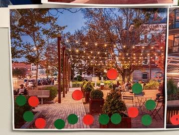
VISUAL PREFERENCE SURVEY
Community outreach included a visual preference survey set up in the Town Hall hallway, as an interactive station inviting participants to mark their preferred
precedent images across 14 different categories. The results were compiled and ranked according to the number of votes each visual activity received (category results are documented in the Appendix).
VISUAL PREFERENCE SURVEY TOP RESULTS
DESIGN SESSION & PRESENTATION
During the design sessions, each team engaged their virtual team members, analyzed key site images, aerials, maps and historic images to define their goals, and sketch their design ideas. From these the first workshop days and the design sessions, teams prepared their presentation slides with different visual media to present their concepts to Thompsonville community members. During brainstorming sessions, teams defined the specific goals and ideas they wanted to address in the town, each team member took responsibility over a particular segment in their group focus area and then team members compiled these ideas together that were presented to community members.
Aside from the site visit, design ideas were also based on town reports, plans and other documents that were developed over the past several years. Some of the documents teams referred to are below.
At the end of the workshop, community members were introduced to the D-PRAT team and the overall process, followed by reports on initial findings and ideas by each team. This initial community presentation was held at the town hall and attended both in-person and virtually.
Some of the slides from the Design Presentation, the teams represented their ideas through mixed media
The presentation initiated a critical conversation with community members, which addressed the problems and notions that people shared during the various sessions. The teams received positive feedback and excitement from the public on the outcome of this initiative.
The session ended with a Q&A where the public was open to add any comments or questions for the teams. The groups gained additional information and insight into how they would keep evolving their ideas and plans for the final report.
CENTRAL ENFIELD
Three Nodes representing interlocking 5 minute walk radii in Central Enfield - Train Station, Historic Downtown, and Town Green. Primary connectors (in green), mixed-use nodes (in yellow) and key opportunity sites (in pink)
03 YOUTH ENGAGEMENT
Youth engagement is important because their views, issues, and concerns are often not included in discussions about their neighborhoods. As a result, community design solutions may not address their needs. Youth were asked to locate on a map the areas that they considered to be dangerous (red dot), areas that needed improvement (yellow dot), spots that they liked (green dot), and places they hang out (blue dot).
It was interesting that several youth found the parking lot off High Street in front of the small strip mall to be an area they liked with one saying it was their hangout (Area 3). When asked why this location, it was reported by the youth that this is where the school buses pick up and drop off students heading to class. It was learned from the students that apparently the school attendance boundaries for the Thompsonville area use Freshwater Creek to determine which schools the students attend. The students said that this was one of the few areas where they can gather in the mornings to see their friends before heading to school. There are no schools within either walking or bicycle distance in Thompsonville as they are all on the east side of the interstate. It is not until high school that they are able to attend together. With regards to Freshwater Pond (Area 4), several youth reported that they enjoyed the ducks and other wildlife that frequent the pond (six). However, three also cited that the pond occasionally has objectionable odors. Other issues included homeless people or
There are five areas of note. The youth were very positive about the Enfield Town Green (Area 1 on the map) with six indicating they like the Green and six saying the Green was their hangout. The sole yellow dot at Enfield City Hall was from a youth that said their grandmother had difficulty using the entrance stairs to City Hall.
A second area (Area 2) that the youth cited was the Community Center with 11 saying this was their hangout and three marking it was a spot they liked.
those that drink make the area feel unsafe. Pearl Street between High and Main Street was cited as dangerous or needing improvement primarily due to car speeds and safety concerns when crossing the street. Youth also said they felt unsafe at night because of the general lack of street lighting. Youth did like the grocery store and restaurant on Pearl Street. The photo shows the evening lighting conditions.
The boat launch ramp (Area 5) was described as needing improvements by three youth, dangerous by two and either a place they liked or a hangout by two. The improvements mentioned included constructing a safe swimming area away from boats and better fishing sites. The dangers cited were people launching boats and noise and commotion.
A small number of youth found the Pearl Street Library to be an area they liked (two) and for one it was their hangout. However, other youth said that it was a to far to walk or bike to it from their homes
Youth also noted locations within Thompsonville that were noted to be unsafe for a variety of reasons including fights, dogs, traffic, and others.
Kids in town have a few hubs they have mentioned.
• The Boat launch/riverside for fishing
• The Basketball Courts and Playground behind Town Hall
• The Alcorn School activity center
These hubs seemed to provide spaces for shared experiences amongst younger kids
in the area. Active play seems to be big for them. Other active forms of play should be considered when considering youth in future plans. Ideas like skateparks, natural playground parks, boardwalk amenities by the river and activity centers are all great examples of elements that could enhance the experience of youth in the area.
Other things to note. There is significant activity from kids in the area, specifically kids on bikes traveling down the hill to reach the basketball courts or pond by the Town Hall. Safe bike facilities such as dedicated lanes and complimentary amenities like easy access bike racks or bike repair stations should also be considered in the near future.
Center on Main Street was a major disap pointment.
While the new Community Center is well liked, the old center was considered to be more central and had better access to their homes.
common area was observed to be in high demand during early evening hours. Youth playing basketball on a Friday evening were included better bleachers so more friends can come and watch, better lighting, and a second court. The photo of the youth playing shows the conditions of the basketball court that the youth had issues with. One youth also said an important thing that is missing
youth. He stated that he felt it was hard to get to the area on the east side of the interstate where there seemed to be more job
FRESNO STATE, CA INVOLVEMENT
Students in the Introduction to Urban Design class California State University Fresno were also engaged in developing potential design interventions.
For their projects, the students chose one of three strategies: Designing a Tactical Urbanism solution, Applying Kevin Lynch’s principles from his book Image of the City by identifying Pathways, Edges, Districts, Nodes, and Landmarks withing Thompsonville, or Implementing a design solution by applying Triangulation (the conjunction of people, location, and activity). The Fresno State student’s work is found in an appendix to this document.
04 GROUP 1
WATERFRONT & TRANSPORTATION HUB
CONTEXT
HISTORY
The Connecticut River shoreline at Thompsonville was shaped during the nineteenth and early twentieth centuries by freight and passenger rail, industrial mills and factories, and the bustling ThompsonvilleSuffield bridge.
Today, land use is divided between aging utility power facilities and private residences, leaving the waterfront neighborhood quiet and this section of river serene.
In 2018, new T.O.D zoning regulations provided an opportunity to revive the economic output of the neighborhood by allowing multifamily and mixed-use development.
With one 157-unit residential project underway and another similar project proposed, the Town now seeks to manage this growth and respond to the public’s desire for river access.
Historic Riverfront view detail.
CONTEXT
CHALLENGES AND OPPORTUNITIES
Future Train Station
Connecticut Department of Transportation (CTDOT) plans to build a new commuter train station in Thompsonville in 2025. Rail connections to Boston and New York could appeal to new residents and increase real estate values. The train station should also increase visitorship to Thompsonville, especially on weekends. Transit access could provide a rationale to lower or waive parking requirements for nearby transit-oriented developments (TODs).
Conversely, station parking at adjoining sites could preclude or hinder more productive or valuable land uses at those sites. Increased vehicular traffic could create a bottleneck at the Main Street underpass and restrict safety and accessibility for pedestrians and cyclists. Finally, in order to reinforce the rail line for more trains and longer stops, CTDOT intends to close the existing Asnuntuck Street underpass.
Image of the location of Future commuter train station.
Image of the Station of Thompsonville.
A range of transformative ideas to revitalize the Riverfront district are proposed and focused on key areas. Along Main Street, from River Street to Shoreline, a new pier and mural at the smoke stack could serve as a regional landmark and anchor for a future river walk developed through private investment. Restaurants facing Main Street and contiguous public boardwalks could create a vibrant promenade while preserving
river views through strategic building designs. Enhancements to the boat launch, including low-cost programming, would attract visitors, generate revenue, and offer valuable open space for residents. Improved pedestrian and cyclist amenities at the Main Street underpass, coupled with keeping the Asnuntuck underpass open, would connect the riverfront to regional biking routes. Finally, introducing a one-time fee
in lieu of on-site parking at transit-oriented development (TOD) sites could fund muchneeded structured parking downtown.
Sketch Diagram showing opportunities and future interventions
OBJECTIVES BASED ON LOCAL INPUT
What we heard from Enfield community members during our Open House on 10/21:
• Officials and residents supported private residential developments in the riverfront area.
Objectives based on these inputs were developed respectively:
• Propose ways to make the Riverfront neighborhood more marketable by encouraging a sense of place, preserving historic architecture, and addressing a perceived lack of parking and public safety.
IDEAS FOR THE RIVERFRONT DISTRICT
Based on the history, challenges, objectives, and opportunities, we developed a set of ideas for the Riverfront district. Each idea is presented more fully in the sections below:
WATER AND NATURE CONNECTION
• Smokestack
• Pier & River walk
• “Once people arrive by train, how will they know where they are or which way to walk?”
• Residents prefer leisure activities at the riverfront, such as walking, biking, and fishing, or organized sports, power boats, and more active recreation.
• Improve visibility and circulation between the riverfront and downtown (at Main Street and Pearl Street).
• Leverage private developments to preserve and improve upon existing public access to the Connecticut River.
• Main Street
• Boat lunch activation
HISTORIC PRESERVATION AND INTEGRATION
• Historic walk & River walk
• Smokestack restoration
• Historical interpretive signs
FOSTERING PARTNERSHIPS
• Retail along Main Street
• Leverage private developments
• Connect to future and existing projects
GROUP 1 RECOMMENDED INTERVENTIONS
1. Main Street from River Street to Shoreline
A new pier and mural at the smoke stack could create a regional attraction and wayfinding point. The pier should anchor a “riverwalk” constructed by private developments over time.
2. Private Development Sites
Restaurants should face Main St. to create an active promenade; developments should create a contiguous new public boardwalk; Town could dictate building envelopes to preserve river views.
3. Boat Launch
Low-cost programming could attract visitors and provide revenue to help maintain and improve the boat launch. Over time, urban design enhancements could make this site an important open space amenity for new residents.
4. Connections to Downtown
Provide pedestrian and bicyclist amenities at the Main Street underpass to ensure that the riverfront is connected to regional recreational biking routes. We also advocate for keeping the Asnuntuck underpass open for pedestrian and cyclist use.
5. Parking Policy
A one-time fee in lieu of on-site parking at TOD sites could help fund structured parking downtown.
OVERALL STRATEGIC PLAN
The Town of Enfield should prioritize three essential public amenities when approving new developments at the River Street sites.
First, commercial and restaurant spaces should be positioned to face Main Street, fostering a lively pedestrian promenade that connects River Street to the shoreline.
Second, a continuous north-south boardwalk should be developed along the coastline in partnership with private developers. This boardwalk will provide a pedestrian- and cyclist-friendly pathway, linking Main Street to the public boat launch and the newly planned pedestrian street.
Third, design guidelines must be established to protect the views from the downtown area and the CTRail platform towards the river. Furthermore, the riverfront boardwalk could integrate with a shared-use trail along River Street, creating a circular walking route that accommodates activities such as dog walking, jogging, and leisurely strolls.
These identified points highlight areas where crossings require intervention to become more pedestrian-friendly. Enhancements at these locations will ensure better connectivity between the pedestrian trail and South River Street.
The pedestrian trail should be constructed using environmentally friendly materials that promote a seamless connection between residents and nature. Inspired by the Austin Pedestrian Trail along the lake, this approach emphasizes creating spaces on the new boardwalk that encourage lingering and engagement, rather than simply passing through. Incorporating open, shaded structures will enhance the experience, providing comfortable areas for relaxation and interaction while maintaining harmony with the natural surroundings.
It is crucial to establish clear guidelines for housing development near the waterfront to maintain and enhance the connection between the town and the river. Buildings in this area should be designed to create spaces that foster interaction between the urban environment and the waterfront, rather than obstructing access. Public walkways should remain accessible and be complemented with street trees and enhanced landscaping to improve the pedestrian experience. These measures will help ensure that the waterfront remains a welcoming and vibrant public space.
This re-purposed space will serve as a vibrant destination, inviting visitors to explore the rich history of Thompsonville. Anchored by the iconic smokestack, a proud landmark, the restaurant will honor the area’s heritage while fostering a welcoming and dynamic gathering place for the community. Additionally, the space will include areas for retail and services, further supporting the lively atmosphere of the newly extended Main Street and enhancing its appeal as a hub of activity and connection.
Along the path, public art installations and informational posters will showcase the rich history of the area, creating an engaging and educational experience for visitors.
The Main Street and Asnuntuck underpasses can be transformed and serve as pedestrian passages, providing improved access to the waterfront projects. To enhance their usability and safety, they will require thoughtful lighting interventions.
G1-1 // MAIN STREET FROM RIVER STREET TO SHORELINE
Boardwalk
The Town should begin implementing a contiguous boardwalk providing a public right-of-way linking the boat launch, the pier and promenade at Main Street, and the northern end of the riverfront district, where a secondary railroad crossing could be constructed in the future. Private developers can construct sections of the boardwalk as successive parcels both north and south of the boat launch are approved for development.
• Main Street from River Street to the shoreline should be pedestrianized.
• Commercial, retail, or restaurant spaces within new developments at this intersection should face onto the pedestrian street.
• The existing smokestack should be preserved to enhance visibility from downtown at Pearl Street and anchor this new district. The smokestack provides a unique canvas for a commissioned mural or art project.
• The pedestrian street should connect to north-south boardwalks along the river constructed by the proposed private developments.
• The pedestrian street should terminate at a viewing platform or new pier at the former location of the Thompsonville-Suffield Bridge.
Walkable
transit connection
The block of Main Street between River Street and the Connecticut River could become a vibrant pedestrian promenade leading to the new Thompsonville pier. The Town should encourage private developments to the north and south to locate parking entrances on River Street away from this intersection, and create commercial frontages on Main Street (discussed further under Idea #2).
Portions of this new public space could be licensed for outdoor dining and live music; the central corridor would bring visitors out to the pier and boardwalk.
Schematic layout showing a north-south boardwalk providing a pedestrian- and cyclist- friendly right-of-way along the shoreline connecting with Main Street and the new pedestrian street.
Sketch of an accessible path leading from future rail platform to River Street development, attractions and the riverfront area.
Pedestrian Street/Promenade
The block of Main Street between River Street and the Connecticut River could become a vibrant pedestrian promenade leading to the new Thompsonville pier. The Town should encourage private developments to the north and south to locate parking entrances on River Street away from this intersection, and create commercial frontages on Main Street. Portions of this new public space could be licensed for outdoor dining and live music; the central corridor would bring visitors out to the pier and boardwalk.
possibilities of retail development warehouse
Image of the current local business to showcase
Left to right: existing streets and details that are integrated on the promenade highlighting local culture
Imagining a pedestrian street at Main Street from River Street to the shoreline, with new developments on the north and south frontages.
The new pier should utilize the historic bridge pilings. Respondents to the visual survey identified with the Bridge of Flowers in Shelburne, Massachusetts as a precedent. Varied elevations could create spaces for walking and spaces for sitting to enjoy the northward view of the Connecticut River.
Reference Image Imagining the north-south boardwalk
Pier launch boat activation collage
Eversource Smokestack
Any mixed-use development of the Eversource site should preserve the iron smokestack and capitalize on its prominence as an iconic wayfinding point and artistic canvas. The smokestack is visible from near the downtown intersection of Main Street and Pearl Street. Therefore, illuminating it could indicate the route to the train station and riverfront for pedestrians downtown. Engaging with local artists could create a distinct mural that complements the new promenade and anchors the pier.
Photo of existing smokestack
Historic Image from Main Street looking east toward the Freshwater Pond
Imagining the view of the smokestack from Main Street, drawing visitors toward the water.
Reference Image: Smokestack Redevelopment
History walk
Precedent image:
Historic preservation and adaptive reuse at former creamery site in Bloomington, IN.
Create “history walk” along shoreline highlighting former building sites that were part of the mill operations. Interpretive signs would foster a sense of place in this new mixed-use district. The walk could also highlight the remnants of a historic bridge, incorporating the remaining pilings as tangible links to this legacy. Interpretive signage would offer engaging historical context, fostering a strong sense of place and connection in this emerging mixed-use district.
G1-2 // RIVER STREET PRIVATE DEVELOPMENT SITES
In approving new developments at the River Street sites, the Town of Enfield should seek three public benefits: (1) commercial frontages on Main Street to create a pedestrian promenade; (2) continuous northsouth boardwalk along the shoreline past the public boat launch; (3) designs that preserve the viewshed from the CTRail platform.
Additional Guidance:
• Commercial or restaurant space in new developments should face a new pedestrian promenade on Main Street between River Street and the shoreline.
• The Town should work with developers to construct a continuous north-south boardwalk linking to the Boat Launch site.
• Design guidelines could help protect the viewshed from downtown and the train station toward the river.
• The riverfront boardwalk could connect with a “shared use trail” along River Street to allow for a circular walking route through the neighborhood, a convenience for dog walking, jogging, and leisure.
Reference Image: River Walk
Using historical maps and images to create interpretive signs (the “history walk”)
An example of a floating restaurant and dock able to withstand flooding on the Ohio River in Lawrenceburg, IN
G1-3 // BOAT LAUNCH ACTIVATION
We recommend the following urban design concepts to create a true public space amenity at the boat launch site for visitors, existing residents and residents of the new mixed-use district:
• Right-size parking by reducing spaces where possible
• Preserve existing trees and expand tree wells
• Add overlook with seating areas between parking and beach,
• Create connection with shoreline boardwalk
• Create connection with Asnuntuck underpass
• “Floating trees” in the river could create safe area for non-motorized boaters
Boat launch activation design proposal plan, check next page for the legend of the different elements
Access via the Asnuntuck Street underpass can be preserved for those on foot and bike, improving access to local amenities. Planned improvements include murals, benches, bioswales, and trees to enhance the underpass.
Pedestrian crossing to enhance the crossing of pedestrians from South River Street and Asnuntuck Street.
Add wayfinding signs at the intersection of South River Street and Asnuntuck Street.
Trail and trailhead to increase the connectivity to the boat launch to the train platform, riverwalk front, and Asnuntuck Street underpass. Squared trailhead includes benches, trash cans and bioswales.
Existing buildings should be saved for later use; for example, housing, small shops (seasonal or coffee), and bathrooms.
The area around the buildings can be activated with tables and a children’s playground.
This parking lot serves regular users of the activated areas and trails which incorporate bioswales and expanded tree coverage.
The design for the truck and boat parking lot will incorporate bioswales and expanded tree canopy.
The active areas will feature playgrounds designed for kids.
A boat launch overlook would provide a place for people to visit, walk, watch boating activity, and enjoy daytime views of the Connecticut River. Improvements include the addition of benches and colorful native plants and trees, with the preservation of as many existing trees as possible.
Despite not requiring immediate reconstruction, the boat ramp may be a candidate for a future project. When reconstructed, a ramp with eco-friendly materials could help filter pollutants from trucks and boats.
Floating trees will safeguard the shoreline from boats, create a home for aquatic wildlife, and act as a natural barrier between the boat launch and the ecosystem.
Pedestrian access will be separate from vehicle access (cars, trucks, and boats), ensuring safe crossings.
We will maximize the preservation of existing trees and supplement with native trees to increase beauty and canopy cover.
Closing the Asnuntuck Street underpass will minimize the positive impacts of planned bike and pedestrian improvements along the riverfront by closing off one of the only two access points to that side of the community. The image below illustrates that, even if the underpass were closed to vehicular traffic for safety or structural reasons, it could still be an important pedestrian and cyclist amenity with proper lighting and maintenance.
Main Street/Train Station
Plans for the CTRail Enfield Station include, in a later phase, a southbound platform on the west side of the tracks and a “pedestrian overpass tower” (Enfield Railroad Station
Environmental Assessment, May 2024). We believe the overpass and second platform are important visitor amenities that will improve the riverfront neighborhood significantly.
The Town of Enfield could seek to create paths and amenities allowing pedestrians to use the overpass as a safe means to access not just southbound trains, but the riverfront. This would help relieve the Main Street tunnel bottleneck.
Future crossing
In designing a comprehensive neighborhood strategy, the Town could plan for a future rail crossing to the north at Whitworth Street to provide convenient circulation.
PARKING POLICY
Structured parking can cost between $20,000 - $40,000 per space to construct. At the riverfront development sites, building parking could be even more expensive due to difficult access and flooding. Structured parking inhibits pedestrian-oriented design features. Meanwhile, these sites will benefit from direct access to public transit. Accordingly, these sites are suitable candidates for lower required parking ratios and off-site parking. Rather than requiring developers to build two spaces per unit on site, the Town could consider accepting a fee in lieu of parking, payable upon site plan approval. This would create a revenue source that the Town could dedicate to building structured parking downtown, where it is most needed. Residents at the riverfront sites could buy permits.
Existing railroad crossing connection with mural enhancement from the riverfront, and existing from the town side.
Existing railroad crossing connection near Bigelow Commons, Main Street underpass.
05 GROUP 2
MAIN ST CORRIDOR & FRESHWATER BROOK
GROUP 2 RECOMMENDED INTERVENTIONS
This chapter outlines strategies and projects to help revitalize Thompsonville’s downtown core. Recommendations include infill strategies for key downtown parcels, street improvements to Main Street, and public space improvements in and around the Freshwater Brook.
OVERALL GOALS
• Provide opportunities for new walkable, mixed-use housing in the downtown core that can leverage future TOD investment at Enfield station and demand for downtown commercial activity.
• Establish strong multi-modal connections through the area connecting Enfield Station, downtown Thompsonville, and other key destinations in the core.
• Stabilize and enhance the Freshwater Brook corridor to make it more safe and welcoming.
• Encourage adaptive reuse and reinvestment of key historic assets.
• Consolidate and manage a central core of parking in the downtown for businesses.
PROPOSED INTERVENTIONS
• Work to stabilize distressed rental properties in and introduce new, “missing middle” housing to the Cottage Green neighborhood. 1. Freshwater Brook/Park Revitalization 2. 78 and 92 Main Street Infill and Preservation 3. 2-4 Pleasant St Infill 4. Main St Streetscape/Urban Design Plan 5. Pop Ups/Tactical Infill 6. Pearl/Asnuntuck/High St Redevelopment 7. Freshwater Pond Trail Improvements 8. Cottage Green/Keller Avenue Pocket Neighborhood
9. Multi-modal Network
G2-1 // FRESHWATER BROOK RESTORATION PLAN
Over the years, the creek has suffered from pollution, erosion, and overgrowth, becoming an underutilized asset in the heart of the town. The program recommends that the Town apply for a creek restoration program in order to clean the freshwater brook, stabilize its banks, and introduce native vegetation, creating a healthier ecosystem that benefits both wildlife and residents. By addressing environmental concerns, the project seeks to reduce flooding risks, improve water quality, and enhance the aesthetic appeal of the area. A restoration effort is envisioned as a cornerstone for sustainable urban development, aligning with broader goals of environmental stewardship and climate resilience.
In addition to ecological improvements, it is recommended that the restoration initiatives integrate recreational amenities to maximize community enjoyment of the space. A thoughtfully designed network of walking and biking trails, picnic areas, and
educational signage about local flora and fauna would transform the creek corridor into a vibrant public space. These features would provide opportunities for outdoor activities, encourage healthier lifestyles, and foster a stronger sense of community.
Potential Funding Sources:
• Federal Grants: Programs like EPA’s Clean Water State Revolving Fund, USFWS’s Partners for Fish and Wildlife, NOAA’s Community-Based Restoration Program, and NRCS initiatives (e.g., EQIP) support creek restoration.
• State Funding: Connecticut DEEP offers grants like the Open Space and Watershed Land Acquisition Program and Habitat Restoration Grants, alongside the Connecticut Clean Water Fund.
• Local and Municipal Sources: Municipal budgets, stormwater utility fees, and community fundraising can provide local funding for restoration efforts.
• Private Foundations and Nonprofits: Organizations like the National Fish and Wildlife Foundation (NFWF) and The Nature Conservancy, along with corporate sponsorships, often fund conservation projects.
• Community and Academic Partnerships: Contributions from local land trusts, universities, and volunteer initiatives can supplement funding and provide technical support.
San Geronimo Creek
Muskegon River Bridge
ALIGNMENT OF CREEK RESTORATION WITH ENFIELD’S TOWN GOALS
A creek restoration initiative in Thompsonville, Enfield, Connecticut, aligns closely with several objectives outlined in the town’s key planning frameworks, including the 2023 Plan of Conservation and Development (POCD) and the Municipal Stormwater Management Program. These efforts support the town’s broader vision of sustainable development, natural resource conservation, and enhanced community amenities.
The 2023 POCD emphasizes the importance of protecting and enhancing natural resources as a cornerstone of Enfield’s
future growth. Creek restoration directly contributes to this goal by rehabilitating natural habitats, improving water quality, and preserving ecological balance. Additionally, the restoration of creeks can enhance recreational opportunities, creating vibrant public spaces that improve the quality of life for residents and attract economic investment. By integrating sustainable land-use practices, this initiative supports the town’s commitment to preventing environmental degradation while fostering a harmonious relationship between development and nature.
Image of Freshwater Brook
Images of Freshwater Brook
BREATHING FRESH LIFE INTO THOMPSONVILLE
A historic postcard from 1907 featuring the former pedestrian bridge over Freshwater Brook in Thompsonville, Enfield, CT.
The Freshwater Brook acts as a crucial 1/4 mile natural corridor for the Thompsonville community, linking Freshwater Pond and its trail in the downtown area to the Connecticut River waterfront along River St.
This green-blue corridor is strategically positioned amidst dense residential and commercial/downtown activity, while also serving as a connection to nearby multimodal corridors, including the existing rail network, sidewalks, and bike trails.
A comprehensive site assessment and user needs was determined along the Brook to recommend following interventions identified on the map below.
Banks of Freshwater Brook, looking towards Asnuntuck and Prospect St.
Area for providing additional parking for by Main St. along Brook corridor.
A topographic study of Freshwater Brook with recommended programming.
Opportunities for Pedestrian access along Pearl St. and Asnuntuck St.
View of Freshwater Brook from culvert along Pearl St.
FRESHWATER BROOK PROGRAMMING
The programming for Freshwater Brook involves extending pedestrian pathways from the Freshwater Pond trail, across the street from Pearl, to continue along Main St. and Asnuntuck, with key points of interest and stream access along the channel.
Where Pearl, Main, and Asnuntuck intersect at the junction of an architecturally notable culvert, there is a unique opportunity to draw pedestrians to the stream (1). This could be achieved through an accessible ramp and stairs, leading to a brook-side plaza, while also restoring the historic charm of a pedestrian bridge (2) that connects to the community gardens.
The community gardens (3) provide an opportunity to draw people to the brook by designing pathways weaving through the gardens, while expanding the gardens into terraced forms to create a natural connection with the stream, serving as a natural source of irrigation.
The open space along Main St across from Bigelow Commons (5), provides an opportunity to provide parking and serving as trailhead and bike parking for Freshwater brook visitors; along with stream lookout. The parking lot will feature green infrastructure in form of permeable paving and bioswales to capture run-off.
With the cooperation of residents along the brook on Asnuntuck St. (6), there is an opportunity to remove the existing concrete channels and restore the stream’s natural banks, thereby reestablishing its natural flow and ecological function.
FRESHWATER BROOK IMPROVEMENTS: ALONG WEST
ASNUNTUCK
SIDEWALK
G2-3 // DOWNTOWN CORE INFILL
Freshwater Brook bordered by North Main, Pearl, and Asnuntuck Streets
Core
Opportunities for infill in and around the downtown core include:
• Infill at 4 Pleasant (corner of Pleasant and North Main)
• Adaptive reuse/renovation of 78 North Main
• Adaptive reuse/renovation of 86-92 Main
• Infill/redevelopment of vacant parcels between Asnuntuck, Pearl, High, and Prospect Streets
Key Public Improvements Include:
• North Main bike/ped improvements
• Intersection improvements at North Main and Pearl
• Freshwater Brook pedestrian access and circulation improvements
4 Pleasant Infill
Pear/Asnuntuck Block Infill
Plaza
Dam
Asnuntuck St
Main St
Downtown
G2-4 // MAIN STREET ACTIVATION
TEMPORAL TO PERMANENT
Temporary and/ or permanent activation can help incentivize social interaction within the community, create new places that Thompsonville residents can relate to, and bringnew activity and attention to the area. Community events can help draw people from other areas and support other efforts like vacant building revitalization in creating a more active and inclusive community. Flexible design allows for a variety of activity
types and sizes, while the different activation areas can work as “rooms” along Main Street where a variety of programing can happen. Using low cost elements like paint and bollards can help improve pedestrian crossings and create a more walkable and inviting public realm.
The map below shows some areas where potential activation can happen and initial ideas for programing.
Activation Opportunities
Modular Play Features
Outdoor Patio with movie night and pop up event space
Pop up space for farmer’s stand(s) or farm-totable modular
Lawn games/ chairs/ summer concerts
Food Truck Plaza
A new pedestrian crossing increases accessibility from the north residential side of Main Street to some of the activated areas.
Painted buffer - 2’min.
Enhanced pedestrian intersections create a more welcoming environment and establish a gateway to the area.
Activation along Main Street : Temporal to Permanent
A modular temporary structure along Main Street, designed for all ages and abilities, can serve as a catalyst for long-term urban activation. By integrating adaptable elements such as outdoor picnic areas, play zones, temporary bike racks, and platform hangout spots, the space fosters community engagement and enhances walkability. Its modular design allows for easy replication in other locations, creating a network of vibrant public spaces that can evolve into permanent fixtures based on community needs and success. This approach not only revitalizes underutilized areas but also promotes a more inclusive and interactive streetscape.
Image: Main Street Perspective After Activation
Precedent : On a Fence, NY by Chat Travieso
Image: Location of future commuter parking lot near station. Temporary Bike Rack
Modular Play Area
Modular Picnic Tables
Map : Key Map of Main Street Activation
G2-5 // Outdoor Patio
Transforming a vacant infill space between historic buildings into a dynamic, temporary activation zone can enhance the vibrancy of Main Street. By introducing a flexible platform with an edge wall, integrated planting, and a trellis, the space can accommodate various community-driven activities. Popup markets, outdoor dining, play areas, and evening movie nights can bring life to the site, fostering social interaction and a sense of place. This adaptable design not only maximizes underutilized urban space but also supports local businesses and enriches the pedestrian experience, creating a welcoming and engaging destination.
Image: Evening Activation Perspective
Map: Key Map of Main Street Activation
Image: Existing conditions
Image: Morning Activation Perspective
The team developed 3 scenarios to guide the redevelopment of the vacant/underutilized block bordered by Asnuntuck, Pearl, High, and Prospect Streets.
The block’s central location provides a strong opportunity for downtown housing and ground floor retail uses that can build on existing businesses and recent investment along Pearl Street.
The block includes the following underutilized parcels totaling 1.82 acres:
24-46 (town-owned parking lot)
24-69 (town sewer easement)
24-97 (21 Prospect St - privately owned)
24-84 (26 Pearl St - privately owned)
24-83 (83 Pearl St - privately owned)
In addition to a multi-unit house at 25 Prospect and a former church at 25 High Street.
Pearl/Asnuntuck: Scenario 1
SCENARIO 1
This scenario assumes that the town could work with existing property owners to improve individual parcels:
• 2-3 stories, mixed-use residential over retail fronting Asnuntuck on existing parking lot (A, B)
• Adaptive reuse of 26 Pearl Street with rearyard outdoor dining area (C, C-1)
• 2-3 stories, mixed-use residential/office over retail fronting Pearl Street (D-1)
• Surface improvements to provide approx. 69 off-street parking spaces for shared commercial use (G, D)
• Adaptive reuse of church at 25 High (E)
• Maintain sewer easement
PROGRAM SUMMARY
• 14,000sf new retail
• 20-25 dwelling units
• 6,000sf office
• 69 off-street parking spaces
• 1.5 parking spaces/unit
Net density: 14 du/a
Building Height: 2-3 stories
This scenario assumes that parcels could be consolidated and that the town could partner with one or more developers in order to centralize a shared parking lot at the core of the block.
The existing sewer easement could be shifted out to Asnuntuck (or down to High St) as part of a larger upgrade strategy in the neighborhood.
• 2-3 stories, mixed-use residential over retail fronting Asnuntuck on existing parking lot (A, B)
• Adaptive reuse of 26 Pearl Street
• 2-3 stories, mixed-use residential over retail fronting Pearl Street
• Surface improvements to provide approx. 70 off-street parking spaces for shared commercial use (G, D) in central location
• Adaptive reuse of church at 25 High (E)
• Shift sewer easement out to Asnuntuck or to High St.
Pearl/Asnuntuck Scenario 2
PROGRAM SUMMARY
• 15,000sf new retail
• 48 dwelling units including 12 live/work spaces
• 70 off-street parking spaces
• 1.2 parking spaces/unit
Net density: 26 du/a
Building Height: 2-3 stories
This scenario assumes that parcels could be consolidated and that the town could partner with one or more developers to deliver a shared parking structure at the core of the block.
A shared parking structure could provide spaces for shared commercial uses as well as transit riders who can be attracted to patronize downtown businesses convenient to their commute.
Two additional floors of parking could be reserved for residents with any surplus made available to other downtown developments.
The existing sewer easement would also be shifted out to Asnuntuck (or down to High St) as part of a larger upgrade strategy in the neighborhood.
• 4-6 stories, mixed-use residential over retail fronting Asnuntuck and Pearl Streets
• Demolition of 26 Pearl Street
• 132 parking spaces for commercial and transit uses on ground floor
• Adaptive reuse of church at 25 High (E)
• Shift sewer easement out to Asnuntuck or to High St.
PROGRAM SUMMARY
• 30,000sf new retail
• 153+ dwelling units
• 132 off-street parking spaces for commercial/transit
• 229 off-street parking spaces for residential/district
Net density: 84+ du/a
Building Height: 4-6 stories
Pearl/Asnuntuck Scenario 3 - Site Plan at Ground level (Elev. 95’)
Scenario 3 Site Plan at Level 1 (Elev. 105’)
Scenario 3 Site Plan at Level 2 (Elev. 115’)
Pearl/Asnuntuck Scenario 3 Site Plan @ Level 4 (Elev. 135’)
Pearl/Asnuntuck Scenario 3 Site Plan @ Level 5 (Elev. 145’)
Pearl/Asnuntuck
Pearl/Asnuntuck
Church Adaptive Reuse - Church Brew Works, Pittsburgh, PA - https://churchbrew.com/
Permeable pavers for parking areashttps://www.stormwater.com Live/Work Dooryards - Seaside, FL
Scenario 3 Cross section between Asnuntuck and High Streets looking West toward the river.
3-story Live/Work prototype - Hercules, CA
3-story Mixed Use prototype - Kentlands, MD
3-story Mixed Use prototype - Louisville, KY
G2-7 // FRESHWATER BROOK INTERIM HIKING TRAIL
CONCEPT PLAN
The proposed interim hiking trail along the freshwater brook in Thompsonville, CT, presents a unique opportunity to connect the community with nature. This project aims to construct interim hiking trails as a quick-start initiative, which can be executed by public works staff or a community organization. The
trail will feature an ADA-accessible design, utilizing crushed rock surface , grading, and clearing to ensure incivility. Boardwalk sections may be installed over parts of the creek where the terrain does not allow for a natural path. Additionally, the trail can include fencing to ensure compatibility with the neighborhood, solar lighting, and clear signage. To enhance accessibility and safety,
the trail will provide well-marked signs, rest areas, and railings where necessary. It is recommended that town staff and community stakeholders actively participate in the planning process to guarantee that the trail aligns with community and recreational goals.
TRAIL CROSS-SECTION
Creating a community hiking trail involves careful planning and efficient implementation to ensure a safe, accessible, and enjoyable experience for all users. The steps below outline the key phases of construction, starting from site preparation and continuing through ongoing maintenance. The trail is anticipated to be built by public works staff and can be completed in phases. Some sections may require consulting design professionals or constructing boardwalks to manage challenging slopes.
Steps to Build the Interim Hiking Trail:
• Survey the site to map the trail and mark areas needing work.
• Clear debris while preserving natural features.
• Grade the trail for accessibility and proper drainage.
• Add a compacted crushed rock surface for stability.
• Build boardwalks over difficult terrain or water features.
• Install solar lights, signs, guard rails, and fencing.
• Conduct a final inspection with town staff and community groups to ensure safety.
Sub-Grade Preparation
Crushed rock
Aggregate base
Aggregate sub-base Prepared subgrade
Boardwalk on Steep Slope
Ashland Trolley Line
Duplex, Park DuValle, Louisville, KY
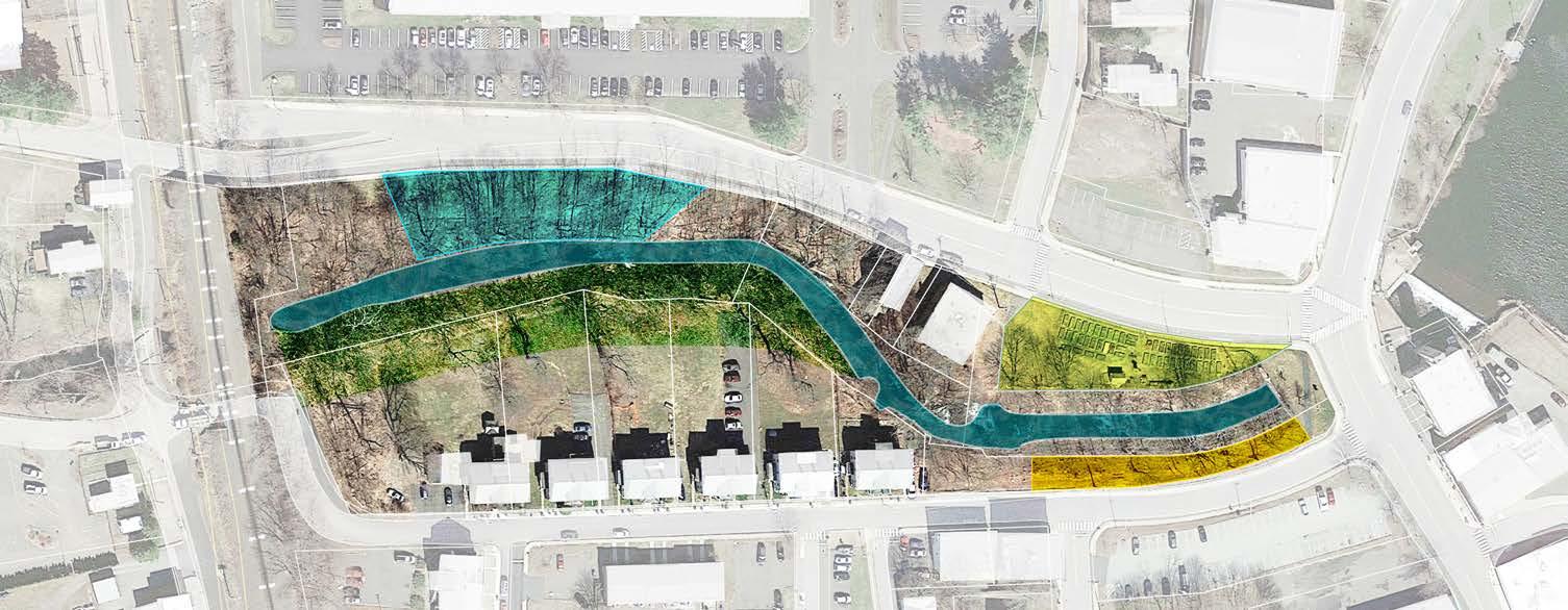
G2-8 // COTTAGE GREEN
The Cottage Green neighborhood can benefit from additional connectivity, especially if the Asnuntuck underpass is closed to vehicular traffic.
The 1.07-acre Town-owned property at 52 Prospect St (24-22, Buildings and Grounds Maintenance Division) could be leveraged to connect Keller Avenue to Cottage Green. Connecting to Keller Avenue would provide additional ingress/egress for emergency vehicles and The site could be developed as a “pocket neighborhood” that arranges cottages around a common open space. Market rate - or middle-income housingcould help to stabilize the Cottage Green neighborhood and serve as a component of a larger neighborhood revitalization strategy, including rehabilitation of Cottage Green houses, streetscape, and signage improvements.
The diagram illustrates how Keller Avenue can connect to Thompson Court and an improved Town Park at 38 Asnuntuck (2438), with a new sidewalk along the park closing the gap between Asnuntuck and Thompson Court, all the way to South Street where an existing at-grade railroad crossing connecting to River St could perhaps be formalized.
Cottage Green Neighborhood - Keller Avenue Connector
Asnuntuck St
Cottage Green
Thompson Court Keller Avenue
Prospect St
High St
South St
Cottage
Keller Court Pocket Neighborhood
The team developed 2 scenarios illustrating a pocket neighborhood at 52 Prospect Street. The concept incorporates the respective adjacent parcels at 1 (24-11) and 14 (24-12) Keller Avenue which appear to be vacant/ underutilized. 46 Prospect (24-27) may also provide an adjacent development opportunity.
Scenario 1 illustrates duplexes arranged around a common pedestrian green space with a meandering drive providing vehicular and emergency access.
Scenario 2 illustrates a central common green space (a “close”) with a one-way loop drive around it.
Both scenarios could utilize permeable pavers and other material changes to help control traffic speeds and maintain pedestrian orientation. The scenarios illustrate duplexes sized similarly to those found in the historic Hartford/Bigelow neighborhood and could be either 2-story townhouses or 1 1/2 story cottages.
PROGRAM SUMMARY
• 25 dwelling units
• .1 acres common open space
• Off-street parking
Net density: 19 du/a
Building Height: 1-2 stories
Scenario 1 - Common Pedestrian Green
Scenario 2 - Central Park Mews
Thompson Ct
Housing precedents for the Cottage Green neighborhoood include historic duplexes in Enfield as well as historic “pocket neighborhoods” oriented to community open spaces in Louisville, Kentucky.
IMPLEMENTATION STRATEGIES FOR INFILL HOUSING
Many of the recommendations outlined above can be funded or incentivized, through various mechanisms including, but not limited to:
• A portion of increment gained from private development created within the TIF district
• Increment shared with a private developers through Shared Equity Agreements in accordance with the TIF Master Plan
• If there is a need for workforce housing in the area, residential development on
second floors could be enhanced through housing tax credits. Note: tax credit units can be designed to fit into mixed-use buildings. They are also a welcome asset to a community attracting business in the retail and service sector
• State and Federal grant programs along with philanthropic support can help support a potential rehabilitation of the former church building
• If possible, seek Enterprise Zone
designation for Thompsonville as a Targeted Investment Community or other designation. This will help create potential incentive systems to attract business to newly redeveloped units in downtown. Once this designation is achieved, and if the community wishes to support entertainment areas downtown, considering pursuing entertain district designation under the CT enterprise zone program.
Duplexes, Columbus, OH
Carriage House, Norfolk, VA
Duplexes on Hartford Avenue, Enfield
Duplex, Park DuValle, Louisville, KY
St. James Court, Louisville, KY
Mews Neighborhood - Louisville, KY
G2-9 // MULTIMODAL NETWORK
MULTIMODAL NETWORK
In order for any one bicycle route to be successful, it needs to be part of a larger network that connects people to places they already want to go.
This proposed network for the Thompsonville area combines on-street routes (turquoise) with off-street trails that can (and should) be shared with pedestrians.
On-street bicycle facilities can have the added benefit of calming traffic, which makes streets safer for everyone: People walking, biking and driving.
1. RAILROAD TRACKS
New paths along one or both sides of the railroad tracks can be built as part of redevelopment in this area.
FRESHWATER BROOK
Build trails along both sides of Freshwater Brook and connect them at the ends to create a great mile-long recreational loop.
RIVER STREET
River Street is already set to be a great bicycling corridor. No changes necessary. All it needs are new connections at either end and some lighting.
SOUTH RIVER STREET
Extend South Street across the railroad tracks with a proper bicycle and pedestrian crossing. Improving safety and providing a valuable additional connection to River Street at the same time.
RIVER STREET
Today, River Street is a dead end. Future River St could be extended to the Franklin Street Bridge for bicycle and pedestrians only. Retaining its quiet character, while also becoming a great community asset.
6. PEARL & PROSPECT STREET
Prospect Street and Pearl Street can become useful north-south bike routes by restriping travel lanes and clearly designating parking areas. No construction necessary. With the added benefit of calming traffic without creating congestion.
7. ENFIELD STREET
Enfield Street (route 5) can become a useful north-south bike route by working with CDOT to build side paths along its ROW and redesigning intersections to shorten crossing distances and slow down turns.
8. ELM STREET
A one-mile ride on protected bike lanes (PBL) along Elm Street connects central Thompsonville with Enfield Square stores without needing to drive.
9. I-91 & HAZARD AVE
New trails along the I-91 and Hazard Avenue Rights-of-Way (ROW) help to create a 3-mile loop trail around the perimeter of Thompsonville.
Proposed Multi-Modal Improvements
Main Street between the fire house and the train station is approximately 43 feet wide. Currently, the lanes lack edge lines, making them feel much wider than they need to be, fostering speeding and discouraging parking. Simply re-striping Main Street with more appropriate lane widths would create 29 safe parallel parking spaces along the south side of the street and still have room left over for a protected two-way bikeway all the way to the train station.
If needed for more parking, the bikeway could be re-envisioned as a 10 foot wide shared sidewalk on the north sides of the street, with the Freshwater Brook trail serving the south side of the street.
MAIN ST: AFTER
In front of Bigelow Commons
The current narrow angle split and the similar one proposed for the train station create an unsafe environment for anyone traveling through to River Street. A safer geometry like the one shown here, “tees up” the railroad connection into a proper intersection. Such a configuration will improve sight lines for those coming from River Street towards town and shorten crossing distances for pedestrians. With the addition of stop signs, this location becomes a safe connection for people biking and walking between the Freshwater Brook trail and the train station as well as the start/end of a possible Main Street 2-way protected bike lane (PBL).
MAIN ST
MAIN ST: In front of Bigelow Commons, going towards River St.
Intersection Improvements at North Main and Pearl
INTERIM TRAFFIC MANAGEMENT
Small, relatively inexpensive interventions, using flexible plastic bollards and highfriction asphalt paint can increase a feeling of safety. These simple and effective strategies are now part of most traffic engineer’s toolkits:
1. Formalize it as an all-way stop and install supplementary centerline stop signs.
2. Extend the centerlines up to or even past the crosswalks and mark their ends with vertical bollards. This safely channelizes turns, slowing down drivers and prevents cutting corners.
3. Narrow travel lanes to 10-12 feet max. This shortens pedestrian crossing distances and creates proper parallel parking spaces.
4. The town should observe behavior for a few seasons and adjust as needed to improve traffic operations and safety.
PERMANENT TRAFFIC MANAGEMENT
After a layout is set, consider replacing and supplementing these temporary materials with more permanent/attractive ones.
1. New concrete curbs can replace painted edge lines and bollards, freeing up space behind the curbs for new street trees and landscaping. New street lights can also improve visibility at the crosswalks.
2. Also, consider raising the intersection itself to curb-height using asphalt or
concrete. This excellent traffic calming measure also eliminates the need for pedestrian ramps.
3. Finally, consider painting the raised portion.
All of these aesthetic improvements reinforce the idea that this is a place to slow down and drive carefully.
INTERIM TRAFFIC MANAGEMENT
PERMANENT TRAFFIC MANAGEMENT
06 GROUP 3
HISTORIC CENTRAL BUSINESS DISTRICT
INTRODUCTION
The focus of this chapter is revitalizing the downtown core through activities and interventions that draw visitors and locals to Thompsonville and visualizing potential longterm infill opportunities near the downtown core. Having a critical mass of both residents and visitors in Thompsonville reinforces a sense of community and supports local business development. We focused on the downtown core on Pearl Street (roughly from South Street north), a portion of Pleasant street, and one parcel on North Main Street (Loaves and Fishes).
During our on-site visit and meetings, the following themes emerged:
Revitalization is more than development. There is a need for opportunities to socialize and reestablish a sense of community. We responded by illustrating events and pop-up attractions that can draw visitors and be an amenity to current residents.
Revitalization supports current residents and businesses. Be inclusive of current Thompsonville residents and established institutions. We include housing recommendations to minimize displacement and encourage a range of housing types for all income levels. Many of the pop-up activities and events would benefit residents of all ages and income levels. Redevelopment plans encourage continuing social service provisions.
Revitalization can preserve or complement historic buildings and architecture. We responded by preparing a mapped database of historic resources and showing how facade improvements can restore or complement historic architectural features.
Revitalization requires a balanced land use approach. A balanced approach of housing, retail and other uses will bring pedestrians downtown. Additionally, too much parking contradicts the goals of the Thompsonville districts and makes development difficult.
Revitalization requires a balanced parking approach. While there is currently adequate parking, there were concerns that new development will require more parking. How can Thompsonville balance realistic parking needs with overall design goals for a walkable downtown.
Based on these themes, we identified projects to meet the following goals:
• Illustrate projects that can make Thompsonville a destination with lively streetscapes, engaging activities, vibrant programming, and a welcoming community spirit.
• Show how the town can foster an appreciation of Thompsonville’s historic assets through preservation, restoration, and re-use.
• Adopt practical, phased solutions to parking concerns while minimizing the impact of surface lots on Thompsonville’s walkable downtown.
• Help ensure that housing meets current and future needs of Thompsonville’s residents and create a robust housing market that supports business.
• Show how historic patterns of development and architecture can be reestablished to better emulate a traditional main street (i.e., buildings closer to road, etc.).
We have arranged this chapter based on whether the suggested interventions can be accomplished in the short-term, long-term or somewhere in between. Obviously, the availability of funding or new opportunities can influence when projects may be implemented.
GROUP 3 RECOMMENDED INTERVENTIONS
Short-Term Projects (Purple)
1. Pop-Up Events: 5 N. Main St., 30 Pearl St.
2. Art and beautification: 26 Pearl St.
3. Outdoor Dining: Sylvia’s, Pearl and High St.
4. Parklets: 23 N. Main St.
5. 23 N. Main Pop-Up Space
6. 95 High St. Activity Space
Mid-Term Projects (Blue)
7. Freshwater Overlook
8. Historic Resource Preservation
9. Facade Program
10. 47 Pearl St. Facade
11. Diana’s Bakery
12. 11 Pearl St. Adaptive Re-Use
13. Green Retrofits
Long-Term Projects (Red)
14. 26-30 Pearl St.
15. 95 High St. Parking Lot
16. 23 N. Main St. Resiliency Hub
17. Pleasant Street Revitalization Plan
18. 2 Pleasant St. Infill
19. Bigelow Parking Lot Infill
20. Pearl St. Reviatlization Plan
21. Pearl St. Town Square
22. Policy and Regulatory Approaches
SHORT-TERM PROJECTS
For little to no cost, a number of projects that can spur revitalization in Thompsonville can start now! These are projects that can be implemented in less than 1-2 years. Low-cost programming and interventions can begin in the short-term to draw visitors Thompsonville through events and art. Additionally, underutilized spaces (e.g. vacant lots, front and side yards, excess pavement) provide opportunities to experiment with activities to attract people to visit and linger in Thompsonville. These types of projects, often referred to as “Quick Builds”, incur minimal costs and minimal commitment beyond a“let’s try it” phase.
Key short-term initiatives not illustrated in this chapter but of critical importance to ensuring Thompsonville is accessible, safe, and attractive include:
• As shown below (in the before & after), stripe on-street parking spaces along N. Main, Pearl St. and Main St. to better indicate parking availability. This low cost solution can start to address the perception of a lack of parking while calming traffic.
• Fix and maintain sidewalks. This includes ensuring curb ramps are ADA accessible.
The Short-Term Projects highlighted in this chapter are non-exhaustive. There are many other ideas that the Town can pursue and passionate, interested residents and businesses may be willing to participate, thus increasing capacity for additional interventions. The below project types are illustrated on the following pages:
• Pop-up events
• Art and beautification
• Outdoor Dining + Parklets
• Additional programming
and after of striping on Pearl Street to encourage on-street parking while slowing down vehicle speed.
G3-1 // POP UP EVENTS
Pop-up events are temporary installations or experiences such as markets, art shows, or food festivals. Pop-up events can be as short as a few hours or can last longer, a few days or even months. The can bring energy and excitement by attracting foot traffic of all ages. These events create opportunities for local businesses, artists, and entrepreneurs to showcase their offerings, and build community spirit. By transforming underutilized spaces with lowcost interventions, pop-ups breathe new life into downtowns and create a vibrant hub of activity.
9 North Main Street
The parking lot and side corner of N. Main and Main (abutting Pleasant Street) presents an opportunity for pop-up uses. It is across from the Community Garden and wellsuited for a Summer Farmer’s Market. 2025
Farmer’s Market Week is Aug 3rd-5th, 2025 and would be a perfect time to introduce the Farmer’s Market. The corner also provides an opportunity to create synergy with the streetscape utilizing through communal art. Influenced by artist-planner, Candy
The existing site has potential for short term activation and long term as a building addition.
Chang, the “Magic Mural” invites community members to share ideas for community revitalization on a giant blackboard centered in the new pocket park.
Rendering of a summer farmer’s market
Rendering of a community chalk board.
Rendering of a community chalk board.
Candy Chang’s “Before I Die” Project, influences the “Magic Mural” as it invites community members to share ideas for community revitalization on a giant blackboard. This blackboard is strategically located on underutilized properties within communities that are in the process of redevelopment efforts. The visioning process is interactive and centers the community within the art (mural making).
Quick Builds + Street Art
Quick builds are projects that are installed within the public right-of-way that use temporary, lower-cost materials to more quickly install a wide variety of projects. To the extent that they incorporate color and art is only limited by budget and ability. The budget-friendly and iterative nature of quick build projects have made them a popular intervention because they accelerate project delivery, provide a platform for experiential public engagement, and help towns make the paradigm shift towards safer, more complete streets.
Quick builds projects can take a variety of forms depending on community needwhat are you trying to accomplish? Adding interest and art, create additional space for pedestrians, spur economic development and placemaking, and/or increase safety for all road users? Quick builds can accomplish this and can be tailored to meet a certain time frame whether they’re installed for just a day, weeks, or even years.
Examples include curb extensions (reducing crossing distances makes pedestrians safer and slows traffic), bus lanes, pedestrian plazas, protected bikeways, intersection art. These are just a few examples of how these types of projects can be implemented in a community.
To create low cost solutions to create separation between traffic and pedestrians, use saw cutting, plastic delineators, direct mount curbing and paint in medians and on- street parking. Trees can either be planted or in large oversize pots. Collectively they will slow vehicle speeds, encourage on street parking while increasing pedestrian safety and stormwater drainage capacity.
Main St. is 43ft wide and with no traffic calming, vehicles travel at high rate of speed.
Passaic, NJ intersection art enhances pedestrian safety, alerts drivers, is a focal point & can involve residents.
Precedents
A wide variety of pop-up events can be established at these and other locations throughout Thompsonville, your imagination is your only limitation!
• Food Truck Festival
• Outdoor Music Venue
• Temporary Ice Skating Rink
• Flea Market
• Farmer’s Market
• Public Engagement
• Craft Fair
• Beer Garden
• Seasonal Holiday Sales
• Movie Night
• Playspace
Examples of pop-up events, from left to right: farmers market, mini golf, pumpkin patch, Christmas tree sales, beer garden,and movie nights.
This 10,500 sf parking lot could be activated with temporary installations, cultural events, and could accommodate vendors with larger footprints. Use concepts range from harvest festival markets in the fall months, to minigolf course installations in the spring. Given the larger lot size, areas could be devoted to vendor vehicles, equipment, or temporary structures while maintaining parking for customers of nearby businesses.
Additionally, the town-owned parking lot located just up the street at 21 Pearl is perfectly situated to provide additional parking in proximity to pop-up events at 30 Pearl. Alternatively, the town lot could be used in the immediate short term as a more rapid installation for some of these types of events.
G3-2 // ART & BEAUTIFICATION
Art can act as a powerful tool for revitalizing a community by visually enhancing neglected spaces, fostering a sense of pride and identity, attracting visitors, boosting local businesses, and promoting community engagement through the creation of vibrant public art, thus transforming a previously rundown area into a more attractive and lively space.
Mural Program
Murals are an effective and increasingly popular mechanism to introduce art into a downtown. Murals on historic buildings may also necessitate a set of reasonable standards to manage the placement and maintenance of murals on historic structures in order to preserve the structures for the future. This could limit murals on unpainted masonry or other best practices.
Examples for program administration, including a call for interested property owners and artists, as well as potential partners, can be found here:
• Mural Makeover
• Public Art | RiseUP for Arts | Connecticut
Food trucks with seating can create an informal gathering place and help small business grow.
The centrally located vacant site in the center of the historic downtown holds promise for short and long term uses.
30 Pearl Street, NW corner of Pearl & High
Pop-up plaza in Arlington Co. VA was created in a parking lot for less than $10,000 including furniture & custom artwork.
Many buildings around Thompsonville would make excellent locations for murals. Murals can be installed simply and add beauty and interest, can be located to complement the use of pop-up event spaces, and are often temporary until redevelopment efforts materialize.
Precedents
To increase urban resiliency and cooling, murals could be completed using sun- and UV-reflecting cooling paint to lower the temperature of historic buildings. New Haven, CT has successfully completed two “cooling” murals in collaboration with Yale Planetary Solutions and the city’s mural apprenticeship designed for Black and Latine artists.
Learn more at: Armory Welcomes City’s Second “Cooling” Mural and Urban Cooling: The Power of Paint in Reducing the Heat Island Effect | PCI Magazine
Hundreds of outdoor murals exist in CT such as the first example shown in Manchester, CT completed by RiseUP for Arts but murals are being used across the nation, see other inspiration images shown.
A wall mural from Davidson, N.C. was a top vote getter at the workshop visual preference survey.
Open Streets
For open street events, streets are closed to vehicular traffic for a day. Streets are closed to vehicular traffic for a day. People bike or walk around the area and engage in activities such as drawing with chalk in the streets. There may be vendors, food trucks, etc. There might be a group ride that begins elsewhere in Enfield and ends in the “open street” location (Thompsonville). Some cities or towns have open streets on an annual basis, while others open streets monthly or even weekly.
Why:
• Builds on other bike path initiatives in Thompsonville and larger Enfield community.
• Creates safe atmosphere to explore Thompsonville by bike or foot.
• Gets people, including children, more comfortable getting around on a bicycle and might build support for additional bicycle and pedestrian improvements.
• Brings people to Thompsonville.
Fire Hydrant Painting Competition
This is a fun, competitive activity to build community spirit and draw visitors to Thompsonville. The Town and/or Thompsonville Fire Department would identify hydrants to be painted and establish an application and hydrant design approval process. Selected participants have a deadline to finish painting the hydrant, culminating with judges selecting winning hydrants.
Utility Box Art Installation
Another fun, low-cost way to add whimsy and interest to Thompsonville is using art on utility boxes. This type of infrastructure, while necessary, is often regarded as an eyesore.
Highlights:
• Can couple well as part of another event (e.g., announce winners at the Fourth of July Town Celebration).
• Prior to announcing winners, it draws visitors to Thompsonville to see hydrants.
• Theme ties in with having a new and old fire station in Thompsonville.
• All ages can participate.
The Town can open this to interested residents and businesses or take a more formal approach and issue a Request for Proposals to artists. An interesting idea could be to allow various artistic styles but ask that a common theme is integrated into the box, e.g. “textiles” as an homage to the Bigelow Carpet history.
Top left to bottom: Dublin, CA; Claremont, CA; Walnut Creek, CA.
Concord Township, OH
West Hartford, CT.
ADDITIONAL PROGRAMMING
Holding community events in the center of Thompsonville can help build appreciation of Thompsonville’s historic buildings and streetscapes, bring foot traffic to businesses, and hint at its potential for revitalization, all while having fun. Enfield currently holds a number of community events, including a Fourth of July Town Celebration, but few if any are located in the heart of Thompsonville. In addition to more traditional events like historic walking tours, the Town could program a number of Thompsonville-focused events that draw residents from Enfield and the greater region.
Kids Storywalk®
A Storywalk® Program engages children by coupling physical activity (e.g., walking) with a children’s book. There are a number of Storywalk® programs in Connecticut, hosted by the CT State Library and by municipal libraries. Multiple boards are installed along the designated walking route and books that “fit” the length of the route are selected and pages installed, with the story changing periodically through the seasons.
Highlights:
• Combines education, nature, and physical activity for children.
• Can introduce children to Thompsonville in a fun, engaging way.
• Can tie to Thompsonville history.
• Program can be designed to use volunteers to “install” the story.
Historic Scavenger Hunt
The Town, Historical Society or a class at the schools could create a scavenger hunt based on an inventory of historic features, facades, buildings, and sites in Thompsonville. Winners receive prizes (e.g., gift card to a Thompsonville business). The Town has conducted children’s nature scavenger hunts in the past.
Highlights:
• Educational; could tie into school curriculum.
• Fun, while showcasing Thompsonville’s historic assets and building an appreciation for them.
• May lead to greater support for historic preservation.
• All-ages.
G3-3 // 95 HIGH STREET
Public engagement with youth revealed that neighborhood kids frequently hang out at this location after school but there isn’t much for them to do here. The parking lot in this large commercial plaza, which contains Serapes and other retail businesses, offers opportunities for infill (see next section), but in the short term could provide a safe space for youth activities such as basketball.
Simple striping in the parking lot can provide a place for kids to play basketball after school. Safety in this scenario is paramount, speed bumps could be added on either side of the basketball striping area and high-vis safety signs. Additional signage could be added to encourage patrons to utilize the other spaces before using the basketball areas; if the lot is busy the basketball area simply would not be available.
G3-4 // OUTDOOR DINING
Activating the downtown can be done immediately by introducing interventions like parklets and outdoor dining which encourage pedestrians to sit and linger, create unique spaces to meet up with friends, or provide a place to enjoy the outside while eating a meal. Permitting these accessory uses through zoning is a critical first step but the Town can further encourage these uses by two methods. 1) Establish a grant program to help create a high quality collection of program brand furnishings that are purchased in bulk by the town and removed seasonally. 2) Create a streamlined, low fee and easy submission process, set design standards, safety and construction requirements. Since these are potentially located in the public rights of way, any exclusive private benefit such as restaurants should obtain an encroachment permit from the town.
Outdoor Dining
Outdoor cafés can bring benefits to both businesses and customers, including creating an inviting atmosphere for people to gather, having extra seating during peak hours, and improving storefront visibility. Outdoor dining spaces can utilize on-street or off street parking spaces, an underutilized wide sidewalk, or alleys between buildings. These are typically established by a commercial business for the use of their patrons. Parklets on the other hand can be sponsored by public or private entities and are intended
to be used by any member of the public, essentially as an extension of the Town’s pedestrian realm. See the Appendix for additional guidance on outdoor dining and
parklets. The following images illustrate various locations before (left) and after (right) outdoor dining has been added.
Outdoor dining concept on Pearl St. near High St.
Existing condition: on Pearl St. near High St.
Outdoor dining concept for Sylvia’s on Pleasant St.
Existing condition: Sylvia’s on Pleasant St.
G3-5 // PARKLETS
While outdoor dining is associated with a private business, parklets and pop-ups are usually temporary spaces offering a place to sit and relax. Parklets are publicly accessible seating areas that serve as extensions of the sidewalk by converting curbside parking spaces into vibrant public spaces. Parklets and pop-ups are social platforms for the community and are often developed through a partnership between local government, local businesses, and neighborhood organizations.
Despite their size and atypical location, parklets can contribute to the public space network and overall sidewalk experience by providing places to sit, relax or socialize. Parklets must be open for use by all members of the public and cannot be reserved for the exclusive use of individual businesses.
G3-6 // 23 N. MAIN POP-UP SPACE
This 0.81 acre property is home to a soup kitchen which serves meals seven days a week (2023 - served over 50,000 meals). The one-story building was built in 1970. The underutilized front lawn area presents opportunities to activate North Main Street, while keeping with the mission of the property:
• Ideas include seating areas, tables used to provide on-the-go meals, and outdoor growing areas for herbs and vegetables.
• Portions of the parking area could also be temporarily reclaimed and used for gathering.
Reclaim underutilized parking areas with parklets like this example in front of the Loaves and Fishes site at 23 North Main Street.
Example of and edible landscaping, New London, CT
Example of hand painted benches, Rutland, VT
Option 1, maintain curb cut and activate frontage along N. Main St.
Option 2, reclaim frontage along N. Main St. by replacing wide curb cut with narrower driveway entry.
MID-TERM PROJECTS
Mid-Term projects entail some level of investment, but often shy away from a full redevelopment and will take slightly longer to implement, anywhere from 1-5 years. These projects can take longer to materialize based on availability of funding and capacity. Knowing mid-term priorities in advance will allow the Town to anticipate and plan for these challenges. The Town can work to identify potential funding sources for the various projects highlighted in this section, including grant opportunities; identify partners and organizations that increase local capacity for grant application, program assistance or oversight; develop relationships with private property owners to prioritize sites and partner on a town-supported RFP redevelopment process; and even consider hiring or training staff with additional expertise that the town might not currently have but would be necessary to implement some of these programs.
Mid-Term Projects:
• Freshwater Overlook
• Historic Resource Preservation
• Facade Program
• Reuse
• Green Retrofits
G3-7 // “FRESHWATER OVERLOOK”
The underutilized space (“Freshwater Overlook”) in front of the Freshwater Pond dam offers a tremendous opportunity to foster a connection between the pond, the brook, and create a focal point. Activating the space will essentially create an extension of the park, which then extends across Main Street to the planned improvements on the west side (per the Connecticut River Access Project), and creates a green corridor from Downtown to the Connecticut River.
The green space surrounding the foot of the dam could be activated with viewing deck, movable seating, and signage enhancing the existing overlook experience of the dam. Installing decking in this area can provide a general gathering location for visitors and residents. This new overlook also can host a variety of smaller events and gatherings, e.g. yoga, acoustic music, outdoor classroom. The deck could include interpretive signage with historical information regarding the history of
Thompsonville and the pond. Adjacent areas, including underutilized land next to the former fire station and fenced-in areas, could present future opportunities to expand the Overlook amenities.
The town should explore alternative methods for safety and security of the dam. Removing the chain link fence and using materials such as panels of safety glass would make the space more. inviting and improve views to the dam and the pond.
Dam area after improvements, view from street/ Photo rendering
Freshwater pond
Dam
Dam area after, view from street / Photo rendering
Existing dam area near sidewalk.
Dam area plan/ Photo rendering
Dam area with outdoor seating and interpretive displays., View from sidewalk/ Photo rendering
G3-8 // HISTORIC RESOURCE
PRESERVATION
The Thompsonville Historic Resource Inventory Map can be a vital tool that links public engagement with the management of historic resources by the municipality. Utilizing the features of an ArcGIS Online map can enhance community participation and the town’s operations in preserving and leveraging Thompsonville’s rich historical assets. This justification underscores its importance by highlighting its benefits to both public users and municipal functions alike.
ArcGIS Online Historic Resource Inventory Map for Town/Internal Use:
• Assess Building Conditions: Identify and monitor deterioration levels of structures to prioritize preservation and maintenance efforts.
• Plan Future Historic Districts: Understand the scope of proposed or potential historic districts to effectively guide planning and resource allocation.
• Manage Town-Owned Historic Properties: Streamline the oversight of historic properties under town control, ensuring proper maintenance and compliance with preservation standards.
• Streamline Historic Structure Permitting and Updates: Offer easily obtainable information on historic structure permits, updates, repairs, and certificates of appropriateness to improve efficiency in town operations.
• Identify Data Gaps: Determine future data collection needs to improve decisionmaking and maintain comprehensive records of historic resources.
ArcGIS Online Historic Resource Inventory Map for Public Use:
• Explore Area History with Ease: Access historic photos and detailed building histories to better understand the rich heritage of your community.
• Engage with Existing Conditions: View up-to-date information about current structures and opportunities for business development within the community.
• Interactive Learning: Use the map as a guide to walk through the area, gaining a deeper perspective by connecting historical context to the environment around you. Use map or QR code on-site.
• Community Involvement: Experience history hands-on by engaging with the map and the physical spaces it represents, making local history more accessible and relatable.
Explore the Thompsonville ArcGIS mapping tool!
https://arcg.is/1CjP5O2
Technology and the advent of mobile apps allows our phones to become a personal tour guide, which is what the Tallahassee based app SmartGuide has created. Mapping and documenting historic assets can have a future as app with a self-guided tour, audioguide, offline city maps.
Designed by tohamina on Freepik
G3-9 // FACADE PROGRAM
Reestablish the town facade program. The town previously had a facade improvement program that is no longer active. Amazing historic “bones” exist throughout Thompsonville, both commercial and residential. Commercial facade improvement programs help small businesses and commercial property owners improve their building’s exterior and storefronts through financial incentives, such as matching grants, loans, and/or design assistance. Programs can focus on properties in both historic and non-historic areas. These types of programs are designed to assist with the revitalization of commercial properties by encouraging the rehabilitation and renovation of commercial buildings.
The benefits of improving your commercial district streetscape through a facade program are numerous. Here are just a few:
• Send a signal. Improving facades demonstrates an investment in your commercial district, tangibly demonstrating with financial incentives that the Town is a partner in the success of your commercial area.
• Invest in small businesses. Participating in the program financially helps existing businesses stay in town and can help encourage new businesses to come to town. This partnership can be especially beneficial for smaller businesses who might have a more difficult time finding capacity or capital to invest in enhancements all on their own.
• Eliminate blight and disrepair. In addition to addressing potential health / safety hazards, eliminating “eye sores” has a positive economic and psychological benefit not just for the property in question but other businesses, residents, and customers as well.
• Improve aesthetics. It’s simple, but effective. People (aka customers) enjoy spending time in places that are attractive and interesting. Facade programs work to enhance existing spaces, building on strong historic “bones” or adapting to newer cultural trends that we find attractive (but keeping in mind that trends come and go, so designing a program that focuses on enhancements that can stand the test of time).
Types of Facade ImprovementsConsiderations:
Facade programs can restore historic facades, modernize others, or address code issues. Typical types of enhancements include new windows, improved signage and lighting, paint, replacing inappropriate materials (e.g. doors, OSB boards, etc.) and more. Many programs exist nationally and within Connecticut that can be used to guide the financial framework, program structure, and eligible and ineligible activities.
Windows. There are many instances of inappropriate “infill” of storefront window. This is particularly evident with historic structures where the “new” windows were often smaller and out-of-scale with the rest of the structure. Replacing these and re-enlarging the window openings not only addresses the scale issue but more importantly increases “ground floor transparency” and in doing so, adds street level interest for customers and pedestrians, fostering a place where people enjoy spending time.
Facade after renovation
Facade before renovation
Removal of transparency “barriers”. Just like the benefits of adding appropriate scaled commercial windows, there are many instances in Thompsonville of existing window openings that remain but are blocked. Removing paint, boards, signage, and solid security grates are all additional ways to drastically increase ground floor transparency.
Lighting. Improved lighting can dramatically enhance a facade, improve safety, or draw your attention to an entrance. External lighting sources to illuminate signage is often encouraged, especially in older commercial districts but where warranted, modern lighting and lighting of the facade can add interest even after hours.
Signage. In an older commercial area like Thompsonville, newer sign types such as illuminated box signs feel out of place. Facade programs can help fund more appropriate signage - awning signs, vinyl or etched window signs, blade signs, painted signs, or externally illuminated signs, etc. Placement of signage is also critical, and when possible should be located on the original signage band, particularly for historic structures.
Paint. Paint can either be a great way to freshen up a facade or can be used to help communicate a businesses brand. This type of facade enhancement could - but doesn’t have to - be separate from a public art program that could be utilized to install wall murals.
Materials. Use of high-quality materials and commercial grade materials is needed to withstand the wear-and-tear seen by businesses. Inappropriate materials degrade faster and contribute to a feeling of disinvestment.
82 Pearl Street.
PROPOSED FACADE PROGRAM INITIATIVES
G3-10 // 47 PEARL ST.
The original historic architecture at 47 Pearl with the rock face block along the sides and above the original signage area. Vinyl was introduced at some point to enclose the storefront with a window and door that feel out of scale.
Strategies
Paint transforms! Whether for a more traditional space or something more fun and funky
Reestablish and utilize the sign band
New, expanded windows, window transoms, and a glass door drastically increase the transparency of the ground floor
Repeat architectural details from the decorative panel below the new windows
Top: Existing storefront (Google maps).
Bottom: Historic photos showing original storefront windows.
G3-11 // DIANA’S BAKERY & CARONA’S MARKET
Formerly Diana’s Bakery, this single story structure on a key retail corridor in Downtown Thompsonville could eventually be replaced by a 3+ story structure more suitable to its corner location. That said, the current building is quite large and likely has
an existing commercial kitchen, therefore it is entirely possible that the existing structure may be reused. With that in mind the current structure is in need of some facade improvements - the vinyl was an inappropriate addition and the substantial roof overhang is in disrepair and feels “heavy,” especially on a single-story building.
Stacked brick detail can provide inspiration for a modernization of the facade. Likely this continues under the existing vinyl.
Top: Existing storefront / Bottom Left: Historic photo early 1900s of original three-story, gabled, residential-like structure. / Bottom Right: Historic photo later half of the 20th century post 3-story structure was demolished to a 1-story structure.
Modern touches with glass awning and sconce lights
Add a sense of height with some rooftop seating and string lights, if feasible (slightly beyond a typical facade program)
Increased ground floor transparency with transform and sidelights around door.
Removal of the roof overhang make the facade feel “lighter” and will reveal its true height
Renovated clocktower. A historic preservation priority to repair clocktower and windows, potential to add a light feature inside.
Activate the current “blank wall” leading to the park by providing seating with shade
Add additional interest with the use of murals (shown in the bricked in windows) and planters
Showing a landscaped bump-out on the corner of Pearl/Central. Extend use of trees down Central to help create a “green” connection to the park.
25 Pearl - Caronna’s Market and Clocktower
G3-12 // REUSE OF 11 PEARL ST.
The reuse of existing buildings has played and will continue to play a key role in economic revitalization. That is part of the evolution of any downtown - businesses come and go and the interior and exterior of buildings are modified and updated to accommodate the next use. This process breathes new life into structures while preserving the character and heritage that define downtown Thompsonville.
11 Pearl Street, Fire Station
Here, we focus on the re-use of a visible, notable building in the heart of Thompsonville: the former fire station. Re-purposing the Old Fire Station at North Main and Pearl Streets as a gateway development:
• Converting the site into a microbrewery, coffee shop, or music venue, creating a “third space” for social and cultural activities (The Hot Topic Micro-Brewery).
• Drawing from examples like Ocala, Florida’s fire station-to-brewery transformation,
• Emphasize catalytic development to meet community needs and address a lack of local gathering spaces.
Recommendations:
• Facade improvements/signage to make the site more inviting
• Remove parking stripes
• Add plantings
• Add outdoor seating area(s)
• Add canopy
• Connection to adjacent pocket park
• Preserve/repair the iconic fire station tower as a critical component of this gateway site for visual and way-finding purposes.
G3-13 // GREEN RETROFITS
Adding greenery, even small amounts, in Thompsonville improves air quality by filtering pollutants and producing oxygen, reduces urban heat, can enhance mental well-being, and can help reduce stormwater runoff. There are opportunities to retrofit parking lots and add greenery to buildings themselves. Longer term, the town may wish to create a greening plan for Thompsonville.
Greening with Vines
Vining utilizing trellises and supports that do not increase damage potential while not obscuring architectural details is a possibility for buildings that are not good candidates for public art but still require some beautification.
Vines may provide cooling and shade in less time than it takes a tree to grow tall. The US Department of Agriculture is currently studying the cooling potential of vines in urban areas to determine which vines increase aesthetic appeal the most while reducing water usage and increasing shade.
Exterior: Micro-Brewery (Rendering) Alternative facade and interior treatments could transform the former fire station into a hub of activity in the heart of historic Thompsonville.
Parking Lot Retrofits
Parking areas are scattered throughout the Bigelow Commons site. With few exceptions the grounds, including parking areas, are attractively landscaped. Two parking areas - on the northeast and southeast corners of the site - may provide an opportunity to improve landscaping and drainage with “green infrastructure” retrofits without losing the total number of parking spaces.
Green infrastructure:
• reduces impervious surfaces (possibly counting towards the town’s MS4 disconnect requirements)
• improves the appearance of parking lots
• helps mitigate heat
• is an opportunity to educate people about stormwater management
General Concept:
• Retrofit to provide bioretention (shallow, landscaped areas for temporary storage of stormwater) and infiltration. Reduces the amount of and/or rate of stormwater leaving the site.
• Existing aisle are +/- 22 feet. Make one-way allowing for reduced aisle widths. Reclaim center for vegetated bioretention area.
• Concepts can be used for any lot
I t is recognized that this it is private parking lot and currently there are no requirements or incentives for property owner to spend money on a retrofit. Recommendations are subject to soil suitability / ability to allow for on-site infiltration.
The existing Bigelow Commons parking lot is a great candidate for green infrastructure.
Water harvesting serves multiple benefits like cooling and cleaning water before it reaches the river.
This rain garden in Arlington, VA holds water during a storm and slowly drains
Green Infrastructure is “the range of measures that use plant or soil systems, permeable pavement or other permeable surfaces or substrates, stormwater harvest and reuse, or landscaping to store, infiltrate, or evapotranspirate stormwater and reduce flows to sewer systems or to surface waters.” - US Congress, 2019.
LONGER-TERM / ON-GOING
Revitalization is an on-going, multifaceted process, and some key projects are inherently long-term in nature. Long-term projects often require significant capital investment, a clear vision, and dedicated stakeholders, including investors, property owners, the town, and the broader community. They require careful planning, sustained effort, and unwavering local commitment; it takes time to build this level of support.
On-going projects are those initiatives that do not have a defined endpoint or “completion” date. For example, updating and enforcing zoning regulations may begin in the short term (and is currently underway) but will require continual review, adjustment, and improvement. Conversations around housing goals and policy can be challenging, but are necessary since having a sustainable housing supply in Thompsonville is key to creating a successful local economy. Achieving visible success with smaller, more manageable efforts—such as streetscape improvements, community events, or façade upgrades—can build momentum, foster public trust, and create a ripple effect that attracts greater support for the larger, more complex revitalization goals.
Thompsonville presents a number of infill opportunities on vacant or underutilized lots. Concepts for a few of those sites are presented here.
G3-14 // 26-30 PEARL STREET
Chapter 5 (beginning on page 50) provided three redevelopment concepts for this site. Here we explore additional concepts as shown in plan later on page 93. Infill over the long term could entail a mixed use 3-4 story building with commercial uses on the first floor and residences above. The lot will include parking spaces to accommodate
The vacant lot at 30 Pearl Street offers infill opportunities in the heart of the historic district and become a catalyst to its revitalization.
This sketch envisions a 3 story mixed use and a one story adjacent building on High Street to transition in scale to the residential neighborhood. The image also depicts potential outdoor dining across the street within the parking area in front of 53 Pearl Street.
G3-15 // 95 HIGH ST PARKING LOT
The lot appears to have excess parking spaces, combined with its ideal location in proximity to the pond and walking paths makes this an intriguing potential site for future additional development. The existing retail can remain while new housing with tucked-in parking at the rear can be built along the street frontage on Central.
Current parking requirements would need to be evaluated. Based on current uses, it is estimated that approximately 37 spaces are required for Serapes restaurant and 53 spaces for the retail uses, a total of 90 spaces for the current development. Future housing along Central could remove roughly 30-40 spaces from the current ~99 off-street parking
Top right: Existing parking lot at Serape (image courtesy Google Maps). Bottom left: approximate location of potential future housing, fitting roughly 7 townhomes. Bottom right: rendering of scale and placement of housing from High Street looking northwest to the pond. spaces. Note, that an additional 10 spaces could be striped along the street, which could be counted toward the site development.
Conceptual Plan of seven infill townhomes.
Conceptual rendering street view of seven infill townhomes.
G3-16 // 23 NORTH MAIN STREET
RESILIENCE HUB
Over the long term, 23 North Main Street may be ripe for redevelopment, in a form and site layout that reinforces Thompsonville’s walkable character. The existing building is set back approximately 50 feet from North Main Street, with a parking lot located between North Main Street and the building entrance. This large setback creates a “gap” in the streetscape, as neighboring buildings to the northeast are all set closer to the street. Redevelopment should continue the important mission of serving the community.
One idea is to create a “Resilience Hub” - a community-serving facility the help residents before, during, and after a disruption/ emergency.
It could:
• Serve as warming and cooling center
• During a disaster, provide shelter, showers, phone charging
• During non-emergencies, be a place to obtain supportive services and information
• Be hosted by a trusted organization (e.g., Loaves & Fishes)
• See https://resilience-hub.org/
Redevelopment Considerations:
• Minimum building height of 2 stories
• Building closer to North Main Street, similar to frontage of other buildings along North Main Street
• Reduce width of or eliminate curb cut on North Main Street
Resilience Hubs are community-serving facilities augmented to support residents, coordinate communication, distribute resources, and reduce carbon pollution while enhancing quality of life. (resilience-hub. org)
Images from Future of Small Cities Institute.
Top to bottom: Site location ket map / Eye level view / Concepts for redevelopment.
G3-17 // PEARL ST TOWN SQUARE
Pearl Street Town Square at the intersection of High and Pearl is a generational placemaking opportunity to create a central public space in the center of the historic downtown. The big idea is to combine existing historic buildings, vacant parcels, new infill and the public right of way into a destination supported by an infusion of private investment, new residents and civic infrastructure. As shown in the concept plan, on the Southeast corner, the existing St. Patrick Church and tower serves as the main architectural feature and anchors the space. Two existing vacant parcels diagonal from one another are transformed into flexible outdoor “living rooms”, offering wifi, movable seating, play areas, public art, interpretive signage and support like power, utilities and waste disposal for temporary events to kiosks and food trucks. New development would fund their adjacent streetscapes and contribute to the town square as a way to support their future retail and residents. The new shared streets could have bollards; easy to raise for events but open during off peak for parking and deliveries.
On the left, I’on Town Square in Mt. Pleasant, South Carolina is a similar scale to the proposed Pearl Town Square. On weekends it hosts events and the nearby restaurants use it for outdoor dining while play equipment gives kids something to do.
On the right, Cady’s Alley in Georgetown is a shared street which allows pedestrians and cars to share the same area safely. Brick and cobblestone with speed bumps, planters and narrow width keeps cars moving at a walking pace.
G3-18 // PEARL STREET
Pearl Street is the historic commercial center of Thompsonville and retains many of the important characteristics needed to revitalize. Historic buildings remain, ready to be renovated for another century of use. Several properties are for sale or under common ownership. Infill sites create opportunities to re-introduce new residential and commercial investment.
A parking strategy utilizing the existing public and St. Patrick’s Church parking lots is central to the success. The town should partner with the church to provide extensive upgrades in exchange for public use.
We recommend a comprehensive rebuilding of Pearl St. to allow for updating infrastructure, street lighting, trees and curb extension to improve the walkability and comfort.
G3-19 // PLEASANT STREET REVITALIZATION PLAN
Before and after of 2 Pleasant Street: 3-Story mixed use concept.
Before and after of Bigelow parking lot infill concept for 3-Story townhouses with rear loaded garages.
Pleasant Street Revitalization Plan
Commons Infill Concept: 3-Story townhomes with garages accessed from existing parking lot.
The successful redevelopment of the historic mill to Bigelow Commons coupled with the arrival of a commuter rail station station steps away affords the owner to expand the number and type of units without additional parking. One idea is to infill 45 townhomes along Pleasant St. and Witworth St. that can screen the existing parking, retain views of the historic mill and have rear access garages. Other ideas including tree planting, curb extensions, striping and outdoor cafes. At the corner of Pleasant and Main Street a 3 story mixed-use building can support the growing demand for housing and with shared parking, help revitalize the two historic buildings across the street under the same ownership.
Bigelow
G3-20 // POLICY & REGULATORY APPROACHES
Policy and regulatory changes are on-going, iterative conversations in part because they change over time with new local leadership, new or changing community priorities, and new information or recognized best practices. Additionally, “change” can be difficult so these conversations require time.
In Connecticut, and elsewhere, conversations around housing and zoning can quickly become contentious - these types of policies and regulations can evoke strong emotional responses. This section focuses on housing and zoning approaches, but recognizes that this is not an exhaustive list of policies and topics that the town needs to discuss further.
Thompsonville’s residential vitality was drastically altered in the 1960s, when some neighborhoods were replaced with larger projects. Long-term residents were displaced and sense of community in Thomsponville was impacted. Revitalization efforts New housing policies can be mindful to not induce displacement through development or policies.
Lastly, zoning sets the framework for redevelopment. The town is currently updating its zoning regulations. Past studies have outlined numerous zoning amendments to achieve a vision for revitalization, including the recent 2024 Economic Development Strategic Plan. In this report we highlight a few additional areas for consideration as the town continues this work.
Housing Strategies for a Strong, Resilient Community
In the almost 25 years since the town commissioned the report “Setting the Stage for Thompsonville’s Revitalization”, housing remains a primary issue for Thompsonville. Specifically, addressing the complex challenges of housing affordability, displacement, and development requires a comprehensive and inclusive approach. In addition to maintaining and stabilizing existing housing stock—much of which is historic—there is need for developing additional housing. The population is aging, and there is a need for promoting growth, adding population. In addition, there is a need for affordable housing, supportive housing for those unhoused residents, and stabilization for both homeowners and renters.
The additional housing stock that does need to be built must be sustainable, and resilient—this means adding density in certain areas more conducive for it (i.e., along transit corridors, and paired with (locallycentered) commercial development.
To mitigate NIMBYism and/or public dissention over creating (much needed) affordable housing, emphasize centering placekeeping. That is building for the future needs of current residents (i.e., ensuring they have housing at 25, 55, 75…) The emphasis is maintaining stability and growth across generations, demographics, socio economic condition for the benefit of Thompsonville’s collective future.
The following recommendations outline a three-point plan for housing stabilization and growth. By centering the “YOU” in housing, these recommendations aim to create a framework for sustainable and equitable growth, ensuring that housing initiatives prioritize the needs of diverse community members while fostering stability and opportunity for all. In addition, a program to address absentee landlords–similar to Detroit’s recently enacted Rental Property Compliance Ordinance, that mandates that all landlords obtain a certificate of compliance (remediate all major compliance issues) to collect rent in the city.
(A) Connecticut has the 4th highest rate of foreclosure in the US. As Enfield continues to grow it may want to institute a Long Time Owner Occupants Program (LOOP). This protects homeowners who have lived in Thompsonville for at least 10 years and are income qualified from sharp increases in their tax burden. The LOOP was originated in Philadelphia, PA. Learn more about each program here: https://www.hud.gov/ program_offices/comm_planning/htf
(B) Establish a housing trust fund to develop future and maintain current affordable housing. Communities that create HTF’s may be eligible to apply for grant funding from HUD. Here: https://www.hud.gov/program_ offices/comm_planning/htf
(C) Encourage creative density: gentle density for new developments in neighborhoods with high historic inventory, where demand is predicted to rise.
(D) Explore additional policies to prevent the loss of existing housing through neglecte.g. demolition delay ordinances, evaluating and strengthening the Town’s existing blight ordinance - and assess staff capacity to proactively engage in building and health code enforcement.
2. Anti-Displacement (Development without Displacement)
(A) Form a housing taskforce that includes key stakeholders old and new residents, the homeless, faith-leaders, community service organization, elected officials, youth,
developers, landlords and tenants and homeowners. The purpose of the housing taskforce will be to identify and vet policies that combat displacement, preserve current housing (especially affordable housing), areas for additional development of affordable, supportive and senior housing.
(B) Conduct a thorough public engagement process including charrettes and surveys to determine community needs that will help shape a Community Benefits agreement. Care should be made to include marginalized populations such as the homeless, lowincome (residents earning under 30% of area median income AMI), Senior Citizens (age 55 and older), the disabled, and Veterans.
3. Housing Development + Building New Housing Units
(A) Identify areas suitable for micro-housing units/gentle density or Accessory Dwelling Units (ADUs) that co-locate services specifically for chronically unhoused residents who may find it difficult to find traditional accommodation and require onsite support or counseling for addiction. An example is the Second Wind Cottages in Ithaca, NY/ here: https://www. secondwindcottages.org/
There are a number of small, vacant commercial out-buildings (see middle photo on next page) in Thompsonville, which may be well-suited for conversion to a small, affordable ADU if commercial use is no longer viable.
Existing historic gothic buildings
(B) In historically significant areas (i.e. Cottage Green, top image) focus on creating (rather than building new) housing stock. For example, encourage diversification of existing housing stock within the existing typology (see, “Missing Middle Housing”): Duplexes, Triplexes, fourplexes. (i.e. repurposing, and restoring existing housing suitable for additional units).
(C) Encourage greater housing density surrounding nodal hubs, transit and commercial corridors.
(D) Propose pairing underutilized parking lots with proposed development (i.e., incentivize development that does not create additional parking, but incorporating existing lots into to new development).
(E) “Pocket Neighborhood” Design to build “gentle density” into Cottage Green while maintaining historic character. (See Group 2 design)
As noted, the town is currently reviewing zoning regulations and intends to update the document in its entirety. The following could be taken into consideration as it works on these updates:
• The existing purpose statement for the Thompsonville Districts is “to encourage transit-oriented development in proximity to the planned commuter rail station at Main and North River Streets and to leverage and protect the unique historical and natural features of this area.”
» Recommendation: The key to a vibrant TOD downtown will be a mix of retail and housing, with special emphasis on housing to create a natural clientbase of retail and the rail station. The first step to achieve your vision is people, therefore a statement on the importance of housing should be an added focus in the purpose statement.
• The town is fortunate to have past studies for Thompsonville which offer specific zoning updates that remain relevant:
Zoning Updates
Financial feasibility for new residential and mixed use projects depend on higher densities, structured parking, and a variety of retail uses (per the 2018 Thompsonville Economic Development Strategy). Zoning policies and regulations should help facilitate these goals.
» Recommendation: ;Implement recommendations of the 2013 Thompsonville Zoning Study, including but not limited to regulation changes to accommodate higher residential densities, F.A.R., update the minimum & maximum parking requirements (see next note on parking).
• There are inconsistencies between various regulatory and non-regulatory documents.
This can cause confusion and delay for applicants during an approval process.
» Recommendation: Ensure consistency between various documents, such as the Thompsonville zoning development standards and the town’s Historic Rehabilitation Standards & Guidelines (e.g., restrictive policies regarding building height, form & massing, roofline, setbacks, etc.).
» Recommendation: Assess guidelines for “requirements” and integrate those into the zoning regulations. Ideally, both documents work together to increase predictability of the approval process and the design itself, enabling structure to meet functional, aesthetic, and safety expectations consistently.
» Mixed-Use Business/Residential use is allowed by Special Permit in both the TD-4 and TD-5 zones.
» Recommendation: If this is the ideal use the town wants to see, strongly encourage the town to make this a Site Plan approval instead of a Special Permit (and consider a square footage size threshold that would trigger a switch to Special Permit).
• Outdoor dining in Thompsonville use table is not listed as a permitted use like other zoning tables in the regulations.
» Recommendation: Add outdoor dining and similar uses - parklets, for exampleto an accessory use table for TD zones.
• Financial Institution is a permitted use in the TD-4. Is this a sensible principal use for this part of Thompsonville?
» Recommendation: Perhaps this is based on a specific, existing use, but generally allowing this as a principal use might not be necessary in this district, and the need to access cash for residents in and around this zone could be accommodated by an ATM accessory use.
• Currently, mixed use development is encouraged throughout TD-5 but is required in certain locations - “The first floor of all building space that fronts Main Street, North Main Street, or Pearl Street must be occupied by retail, restaurant, service, recreation, office, or municipal uses. Residential uses are encouraged on upper floors. The intention of this restriction is to provide an active pedestrian environment which provides access to goods and services.”
» Recommendation: The focus on where retail/active ground floor uses are required seems appropriately limited. The town could consider limiting where mixed-uses are permitted (aka, reducing the amount of TD-5 zoning) to further guide/force retail along your priority commercial corridors. [See Map on next page]
of these regulations is encouraged” and references Appendix B- Preserving a Community Historic Rehabilitation Standard Guidelines for The Village of Thompsonville.
» Recommendation: The current language is confusing - which adoption date is being referred to? When the Thompsonville regulations were adopted? The year the Town first adopted zoning? Additionally, it is unclear if preserving “any structure” is truly the intent. Consider identifying a specific date to help preserve the architecture you truly are interested in keeping.
• Currently the Town sets a variety of height requirements, depending on zone, ranging from 35 feet to 55 feet and permits density bonuses that would allow for increased height.
» Recommendation: Current height limitations seem acceptable but the Town should consider minimum height requirements - e.g. 2-story minimum - in key locations (e.g. Main and Pearl).
» Recommendation: Consider development incentives that might be more effective, e.g. parking requirement reductions and even elimination for development along prime retail streets.
• Currently the regulations state that “The preservation of the exterior of any structure in existence as of the date of the adoption
• The zoning regulations do not contain any ground floor “transparency” requirements. “Transparency” is the amount of glass including doors and windows (nonreflective, not blocked, etc.) that can be measured relative to the overall area of a commercial building’s face.
» Recommendation: Potentially looking to existing buildings that are a model of what is wanted in Thompsonville, add a ground floor transparency requirement to the zoning regulations, a minimum of 50% but possibly higher - 70-80%.
Transparency requirements help ensure that streets don’t have excessive blank
Current TD-5 district
Current TD-4 district
Potential locations to remove TD-5 designation
walls, which are counterproductive to the vision of an active and engaging downtown. Transparency also better “invites” customers to visit and visibility can improve safety.
• Currently, residential uses of 2-units, 3-4 units, and 5+ units are allowed in the TD-5 zone by Site Plan but none are permitted in the TD-4 zone.
» Recommendation: Consider further restricting lower density residential that is permitted in the TD-5 zone (e.g. 4 units or less would no longer be permitted), recognizing that there
TD-5 parcels that require ground floor retail along these street facades Currently “gaps” but potential future ground floor retail requirements
would be some existing units that would be made nonconforming.
» Recommendation: Consider modifying the Use Table to permit 5+ residential uses in the TD-4 zone to encourage residential uses in proximity to station (aka, potential riders). Currently the only residential uses permitted in the TD-4 zone are those which are part of a mixed-use development.
Current TD-4 and TD-5 Zoning Districts
Small Reduction in TD-5 Zoning District
*Possibly no nonconforming uses created
More Substantial in TD-5 Zoning District
*Minimum 3 nonconforming uses created
• The regional housing market within and around Enfield has a need for thousands of new housing units for households with incomes of $75,000 or more, according to the 2021 Housing Needs Assessment (included in Enfield’s 2023 Affordable & Fair Housing Plan). New units will then free up the existing housing supply for use by lower-income households.
» Recommendation: Consider allowing 5+ residential uses in the TD-4 zone (i.e., not just “Mixed use with Residential”).
• Housing for Elderly and Senior Residential Development is not permitted in either TD-4 or TD-5 zones.
» Recommendation: It is unclear why these uses are not permitted when other large-scale developments are allowed. Elderly populations, in particular, can benefit from proximity transit (especially when they may no longer be able to afford to own or safely drive a vehicle) and to everyday destinations (e.g. pharmacy, grocery, Town Hall, etc.) within walking distance. Ground floor activation with complementary uses, such as a senior center or pharmacy, would be a nice complement if “active” uses along the street are a concern.
» Additionally, with parking being a common concern, housing for seniors
is a good option as it typically requires (should require) fewer parking spaces to house the same amount of residents that would otherwise desire parking for a similarly sized project.
• Thompsonville has an excessive supply of parking, per the 2015 Thompsonville Parking Study. Prioritizing more parking should not be the primary consideration when contemplating future zoning and housing policy decisions.
» Recommendation: Consider updating regulations to eliminate parking minimums.
» Recommendation: As a first step, consider reducing parking requirements for retail and commercial uses by as much as 50% to encourage a compact,
walkable commercial district and mixed-use projects. Having a shared parking strategy can help achieve this goal.
» Recommendation: Studio and onebedroom units (such as townhomes and apartments) should require no more than 1 space per unit. Residential guest parking spaces can be shared with commercial/retail businesses, especially in compact downtown areas and mixed use developments.
» Recommendation: Consider strategically incentivizing development in key locations (potentially for select uses, e.g. uses with ground floor retail) through parking - even the elimination of parking requirements as an incentive.
07 IMPLEMENTATION
G3-1 Pop-up Events
G1-1 Main @ River Interventions
Boardwalk
Walkable Transit Connection
Pedestrian Street/Promenade
Eversource SmokestackMid
term CTDOT
G1-2 River Street Private Developments
G1-3 Boat Launch
G1-X Other recommendations
Railroad Crossings
G2-1 Freshwater Brook Restoration Plan
Stream Bank RestorationLong term TOE
Access
Pedestrian Bridge
Community Garden Revitalization
Shared Use Path
Permeable Parking Lot
G3-3 Ou95 High St
G3-4 Outdoor Dining
G3-4
G3-5
G3-X Additional Programming
term TOE
term TOE
G2-2 Freshwater Brook ImprovementsLong term TOE
G2-3 Downtown Infill
G3-11
G3-12
G3-13 Green Retrofits
G2-4 Main Street Activation
G2-5 Outdoor Patio
G2-6 Pearl & Asnuntuck
G2-7 Freshwater Brook Interim Hiking Trail Mid term TOE
In general, “CTECO has a lot of GIS resources that may have what you are looking for” Map and Image Services | Connecticut Environmental Conditions Online (uconn. edu)
Heat island effect – Can be generated from Landsat 8 thermal infrared sensor data. “I have a lab that could guide you through the process, easy to do once you have the imagery which can be downloaded from…” https://earthexplorer.usgs.gov/
Bathymetric data – CT Eco has lake bathymetry (may not be what you need)
Town of Enfield/Cunningham Preservation Associates LLC. (2009). Historic Rehabilitation Standards and Guidelines for Thompsonville. https://www.enfield-ct.gov/ DocumentCenter/View/14107/Appendix-BThompsonville-Design-Guidelines-PDF
The Cecil Group/Fitzgerald, Halliday Inc. (2013). Enfield/Thompsonville Zoning Study. https://www.enfield-ct. gov/DocumentCenter/View/24970/ Thompsonville-Zoning-Study-2013-08-27--Cecil-Group
OF THOMPSONVILLE
Nelson/Nygard. (2015). Thompsonville Parking Study Final Report. https://www. enfield-ct.gov/DocumentCenter/View/24974/ Thompsonville-Parking-Study-FINALREPORT_062415
Town of Enfield. (2016). Connecticut River Access Project Presentation. https://www. enfield-ct.gov/DocumentCenter/View/24971/ River-Access-PP-2016
Greatblue/4Ward Planning. (2017). Report of Findings of Thompsonville Market Assessment. https://www.enfield-ct.gov/ DocumentCenter/View/14110/GreatBlue--4ward-Planning-Thompsonville-Enfield-CTMarket-Assessment-Study--October-2017
4Ward Planning (2018). Thompsonville Economic Development Strategy. https://www. enfield-ct.gov/DocumentCenter/View/13905/ Thompsonville-Economic-DevelopmentStrategy---June-2018
Town of Enfield/BL Companies. (2018). Connecticut River Access Multipurpose Path Presentation. https://www.enfield-ct.gov/ DocumentCenter/View/24972/River-AccessPresentation-2018
Fitzgerald & Halliday Inc. (2018). River Gateway Zoning Study Presentation. https:// www.enfield-ct.gov/DocumentCenter/ View/12603/River-Gateway-Study---April2018-PDF
Connecticut Department of Transportation/ WSP. (2019). Hartford Line TOD Action Plan. p.99-111. https://portal.ct.gov/-/media/dot/ tod/hartford-line-tod-action-plan--part-2report-final-pages-102219.pdf
Gorman & York. (2023). Enfield Plan of Conservation and Development. https://www. enfield-ct.gov/DocumentCenter/View/23330/ CT-Enfield---Plan-of-Conservation-andDevelopment---Final-Adopted-Plan-withMap-Book-Effective-5_31_23?bidId=
Town of Enfield. (Varies). Various Plans and Concepts for the Community Collected by ECD. https://www.enfield-ct.gov/ DocumentCenter/View/24981/VariousDevelopment-Concept-Planning
Town of Enfield. (2024). Economic & Community Development Strategic Plan. https://www.enfield-ct.gov/ DocumentCenter/View/24964/Dept-of-EconComm-Dev-2024-Strategic-Plan
• Public Use
» The Thompsonville Historic Resource Inventory Map empowers the public to engage with local history in a significant and accessible way. By providing detailed information on historic photographs, building histories, and their current conditions, the map invites residents and visitors to delve into the community’s heritage. This interactive platform lets users navigate Thompsonville, connect with the surrounding history, and gain new insights. It also highlights opportunities for business development within historic properties, thereby promoting community revitalization and economic growth. Furthermore, the map fosters deeper community involvement by offering easily accessible and engaging historical information, nurturing a sense of connection and pride in the town’s heritage.
• Town/Internal Use
» For the municipality, the Thompsonville Historic Resource Inventory Map is an essential resource for managing and planning historic preservation efforts. It allows the town to assess building conditions and track deterioration levels, thereby prioritizing maintenance and preservation tasks. Additionally, the map provides a comprehensive overview of proposed or potential historic districts, supporting future planning and resource allocation. With readily accessible data on town-owned historic properties and permitting processes, the map simplifies the management of historic structures, ensuring that preservation standards are met while enhancing operational efficiency. Moreover, the tool aids in identifying gaps in existing data, enabling the town to plan future data collection initiatives to maintain a comprehensive inventory of historic resources.
• Data Sources and Limitations
» The data for the Thompsonville Historic Resource Inventory Map was collected from both the National Register for Historic Preservation, managed by the National Park Service, and the Connecticut SHPO’s Connecticut Cultural Resources Information System (ConnCRIS) databases. The National Register provided district polygons and related data, while ConnCRIS contributed site locations and additional information. It is important to note that this map is not exhaustive and remains a work in progress, with ongoing efforts to expand and enhance the available data.
» The Thompsonville Historic Resource Inventory Map is crucial for preserving the town’s historic character while encouraging public engagement and ensuring effective city management. By providing a user-friendly platform for both the public and city officials, it bridges the needs of community members and municipal stakeholders, ultimately supporting Thompsonville’s long-term preservation and development objectives.
HISTORIC MAPS
WORKSHOP VISUAL PREFERENCE SURVEY RESULTS
MURALS
WATERFRONT
STREETSCAPE PARKS PLAZA & PEDESTRIAN MALLS
Sidewalk
Sidewalk
HOUSING
FLORA & LANDSCAPING
Large
2.5/3-story
FRESNO STATE URBAN DESIGN STUDIO
California State University Students
California State University. Fresno
CRP 115 Introduction to Urban Design
Thompsonville, CT Design Projects
Alejandro Barajas
Eric Cephus
Piper Collins
Clara Corl
Aidan Crick
Lizbeth Dominguez
Brenda Gutierrez Mora
Daegan Flannery
George Hernandez
Sydney Macabeo
Jeremiah Munguia
Sean Nunes
Ayanna Perales
Fernando Perez
Teslla Ramirez
Martha Rangel Calvillo
Jonathan Reyes
Vanessa Rodriguez
Catalina Segovia
Curtis Simmons
Dylan Simmons
Richard Vega
Jace Williams
Introduction:
The CRP 115 Class, Introduction to Urban Design, was tasked with developing design interventions for Thompsonville, CT. The students could select one of three urban design strategies:
1. The use of Tactical Urbanism
2. Apply Kevin Lynch’s Image of the City by mapping Edges, Nodes, Pathways, Districts, and Landmarks
3. Use Triangulation (the conjunction of People, Place, and Activity)
The student’s work follows in the digital version only.