
FINAL DRAFT MARCH, 2024

FINAL DRAFT MARCH, 2024
CITY OF NORTH MIAMI
PAULA CHRISTINA VIALA,SUSTAINABILITY ADMINISTRATOR
JEFF GEIMER, INTERIM ASSISTANT PUBLIC WORKS DIRECTOR
DEBBIE LOVE, AICP
AMERICAN PLANNING ASSOCIATION
URBAN DESIGN & PRESERVATION DIVISION
MARIANNE STUCK
KRIS KRIDER
BRADLEY WOLF
ANDREA CRUZ MEJIA (D-PRAT SCHOLAR)
IN PERSON VOLUNTEERS
DAVID GOODMAN
JEFFREY SHUMAKER
SHANNON CILENTO
RAQUEL SAMAROO
HADLEY PETERSON
SONIDE SIMON
KEITH WOODCOCK
REGIONAL RESILIENCY AND HISTORIC PRESERVA -
TION PARTNERS
KARLA EBENBACH
JANE GILBERT
JAMES DUNCAN
ROBERT COLON
CHRISTIAN KAMRATH
NANCY JACKSON
SARAH CODY
TAMARA MCDONALD
VIRTUAL VOLUNTEERS
BRIAN FOOTE
BRYAN LEYBA
CHAOCHEN FAN
DON GIARD
HAILEY HYUN
IPEK KAYNAR ROHLOFF
JASMINE BROWN
MARGARITA SALDAÑA
ONAM BISHT
STEFAN PELLEGRINI
The information provided within this D-PRAT report is for general informational purposes only. While we try to share up-to-date and correct information, there are no representations or warranties, express or implied, about the completeness, accuracy, reliability, suitability or availability with respect to the information, suggestions, services, or related graphics contained in this report for any purpose. Any use of the methods describe within this report are the individual contributor’s personal thoughts. They are not intended to be a definitive set of instructions for North Miami and do not represent the policies or positions of the American Planning Association.
The Urban Design and Preservation Rapid Assistance Team (D-PRAT) is a pro-bono program supported by the American Planning Association (APA) and the Urban Design and Preservation Division within the APA. The purpose of the D-PRAT is to quickly support under-resourced communities and organizations in their efforts to collaboratively plan for the future with a focus on the urban design of the public realm and preservation. The third D-PRAT program began in the fall of 2023, working with the City of North Miami, Florida.
The City of North Miami applied for the program and identified that they were looking for technical expertise to help reinforce designing streetscapes that accommodate green infrastructure like bioswales and shade-providing trees, while also incorporating eco-friendly modes of transportation. At the same time they are interested in the solutions which include the use of native plants as a part of the city’s streetscape design solutions while taking into consideration the unique climate of South Florida. The city is specifically

seeking streetscape design solutions that exhibit resilience to the prevailing climatic conditions, characterized by heat, humidity, and frequent flooding.
The D-PRAT Workshop in North Miami consisted in both an on the ground team and virtual team. The in-person workshop in North Miami was held over two days on November 13th and 14th, 2023. There was also a collaboration between North Miami High School and Cal Poly, California Urban Design seminar to engage youth as part of the project.
North Miami is a suburban municipality located in the northeastern region of Miami-Dade County, characterized by a median income below the national average. Strategically positioned between the Miami and Fort Lauderdale metropolitan areas, the city has strategically situated itself to gain access to valuable markets and destinations. Furthermore, North Miami enjoys the advantages conferred by a well-developed regional roadway network, further enhancing its connectivity and accessibility. As with all of South Florida, North Miami is community facing challenges posed by climate-related threats including rising sea levels, which are anticipated to become more frequent and severe in the future.
The changing environment is also a concern with regard to preservation of historic resources in the area. Understanding the existing built environment and its the historic resources will further goals to foster a stronger connection and sense of pride for the community developed through green street initiatives and other measures. By considering the existing built en-
Map of North Miami showing the frequency of flooding. A large portion of North Miami lies within the historic watershed of the Arch Creek Basin. This former waterway is known as a Transverse Glade, a hydrological formation that naturally channels water from the Everglades to Biscayne Bay. (Meeder and Harlem 2019)
vironment through a high level survey of resources this project folds in recommendations underscoring overarching goals of the MIami-Dade County Preservation office to further document historic structures in North Miami and identify opportunities through which preservation tools can be leveraged to meet community needs.
At present, there‘s a strong desire to expand the mitigating effects of various corridors within the city, with a particular emphasis on advancing and safeguarding the well-being of its residents through green infrastructure initiatives. This underscores the vital role of these corridors, as they serve as a tangible link connecting their rich historical heritage to the promising prospects of a more resilient future. As well, enhance the urban landscape by enhancing incorporating native plants and transforming the streets into vibrant and aesthetically captivating corridors, using green infrastructure such as bioswales and integrating alternative modes of transportation such as bicycle infrastructure.
North Miami wants to activate community pride and identity through the implementation of green street initiatives, particularly in areas vulnerable to flooding. As a result, the community can be empowered to actively engage in the care and stewardship of these newly established green resilience spaces, fostering a profound sense of belonging and ownership within the community. Passive green spaces and underutilized areas, such as street dead ends, warrant thorough examination to discern their potential for ac-
tivation and the implementation of effective stormwater management strategies. Recognizing the significance of integrating these spaces into the broader green infrastructure framework of the city, there should be a commitment to endow these park areas with a distinctive sense of place.
Existing historic resources may lend themselves to projects that support green infrastructure initiatives by integrating these resources into future projects highlighting historic neighborhoods, main streets and individual resources while maintaining the historic character that has defined some areas of North Miami for generations, there by retaining the sense of history and legacy that has been established there.
The exploration of opportunities within historic preservation areas and buildings is deemed essential to foster a accessible community. The preservation of existing housing, the adaptive reuse of historic buildings, and thoughtful infill strategies can reinforce and enhance the character of the existing community.
Adaptive reuse poses a particular point for consideration as it would allow planning aimed to fulfill existing housing needs with already available resources that can be re-purposed to support those initiatives. By preserving historic resources and implementing measures to support adaptive reuse and rehabilitation of these structures North Miami can support long term preservation goals for the area with contemporary planning measures.


D-PRAT ground team members (left to right):
-Keith Woodcock, Lecturer of Urban Planning Cal Poly San Luis Obispo and Fresno State University, CA
-Shannon Cilento, Planned and Community Development in Sullivan 180
-Christina Viala, Sustainability Administrator, City of North Miami
-David Goodman, Active Transportation Program Manager, Jacobs
-Bradley Wolf, City Historic Preservation Officer, City of Kansas City, MO; and Secretary-Treasurer Urban Design & Preservation Division
-Sonide Simon, Community Planner
-Raquel Samaroo, Community Planner
-Hadley Peterson, Community Planner
-Andrea Cruz, Student scholar, University of Texas at Austin
-Marianne Stuck, Associate at Design Workshop, Aspen, CO; and D-PRAT Coordinator for Urban Design & Preservation Division
-Kris Krider, Urban Design Supervisor, Arlington County, VA, Chair-Elect Urban Design & Preservation Division
-Jeffrey Shumaker, Adjunct Professor, Columbia GSAPP (not pictured)
During our site tour, we were guided by our host Paula Christina Viala, Sustainability Administrator for the City of North Miami. She adeptly led us through key locations that illuminated the urban fabric and identity of North Miami. The sites included 131st arch and fountains, Pioneer Boulevard, 125th Street, The Biscayne Canal, the passive parks, the 7th corridor, Joe Celestin Center, Enchanted Forest Park, and Oleander Park.
This experience proved invaluable for our team, as it provided a tangible connection to the previously discussed places. Witnessing these locations in person offered a fresh perspective, allowing us to better comprehend their significance and recognize their potential. Christina’s guidance was instrumental in enhancing our understanding of the urban landscape and contributed substantially to our overall comprehension of North Miami’s character.


The stakeholder meeting was a pivotal moment in our understanding of the many opportunities and challenges facing the city in a time of change. These conversations provided a strategic platform and basis for essential components of our ideas.
A deliberate effort was made to convene key individuals integral to the future of North Miami. This including private sector developers, community advocates, elected officials and leadership staff representing departments crucial to the project’s success. Representatives from the City Manager’s Office, Public Works, Planning and Transportation Department provided key insight. We were privileged to be joined by several Miami-Dade County staff representing, Historic Preservation office, Resilience Office. Joining online were DPRAT virtual volunteers who participated remotely.
On the concluding day of the initial workshop session, we engage with the community. To facilitate this, distinct boards were established to gain comprehensive insights. Each station board was divided in focus groups, each assigned a specific area of exploration.
The first focus group analyzed the passive parks, exploring creation of spaces that foster a distinct sense of community identity and connectivity.
The second focus group was dedicated to examine of the 7th WE street, as having potential for redesign to enhance pedestrian-friendliness.
The third focus group identifying elements perceived as lacking in the city and prospects of refill development, involving the revitalization or re-purposing of existing spaces to better serve the needs of the community.


On the subsequent day, we conducted an intensive design workshop. This session was dedicated to translating the community’s expressed thoughts and concerns into conceivable strategies and ideas for design implementation. Our main aim was to come up with initial designs that could really meet the community’s needs. During the workshop, we made sure to get quick feedback from the community at the end of the day. This ongoing process was all about making sure our ideas aligned with what the community actually wanted.
By the end of the workshop, we shared our design ideas, and the feedback we got from the community was absolutely vital in kickstarting the creation of practical interventions. This collaborative back-and-forth represent highlights insights and perspectives of the community are essential to the decision-making process.


sli de s f ro m th e pre s en t a i on s t o th e co mm un it y


In addition to the workshops and meetings conducted by the City of North Miami and the D-PRAT team, a goal of the Youth Engagement component included hearing from youth, whose opinions and observations are often overlooked by traditional outreach activities. The Youth Engagement activities included a site visit to meet students at North Miami Senior High School and engaging middle school students attending volleyball workouts at the Scott Galvin Community Center.
North Miami High School students provided feedback on what they consider important to them regarding the future of North Miami
After a short introduction about the D-PRAT program and why their responses were important to the City, the students were queried if they have been asked if they felt their voices mattered or what their views were regarding the City, the response from the high school students was a resounding NO.
The students were asked: If North Miami was a person, who would that person be? What is needed in North Miami to be more sustainable? What is missing in North Miami, and What are your favorite places in North Miami?


Students welcomed the opportunity to share their thoughts and engage in mapping activities.


At North Miami Senior High School, in addition to the above questions, students were engaged in a mapping exercise. While the exercise was originally planned to be a city-wide perspective, the students were more interested in looking at the area surrounding the high school. One student remarked, ‘this is where we spend most of our lives’.
What also started as using colored dots to note whether an area was a hang-out (blue or green dot), needed improvement (yellow dot), or was dangerous (red dot), the students wanted other observations to be included and so made notations on the map.
A take away was that the Library, shown with multiple blue dots, was very well liked by the students. Safety was a primary concern for the students. Having greater recreational activities and opportunities outside of high school athletics and sports was also high on the minds of the students.


Concurrent with the workshop in the adjoining room, we visited with middle school age youth engaged in volleyball practice. After a short introduction about the D-PRAT program and why their responses were important to the City, the students were queried if they have been asked if they felt their voices mattered or what their views were regarding the City, just like the high schoolers, the response was also a resounding NO.
These students were also asked the same questions: If North Miami was a person, who would that person be? What is needed in North Miami to be more sustainable? What is missing in North Miami, and What are your favorite places in North Miami?


In reviewing the responses to these questions from the middle school students, a curious reoccurring answer was given: Frozen Yogurt! On the face of it, this may be over looked or explained away as, ‘they’re only 11 or 13’. However, when questioned about why frozen yogurt, it became apparent that the students were expressing a desire for places to hang-out and socialize with friends.
Several commented that they felt there were not enough places in North Miami for their age group to get together.


Transform underutilized parks and open spaces in North Miami into vibrant, resilient spaces by prioritizing active and passive recreation, integrating stormwater management, and fostering community engagement for sustainable use.
Develop and implement strategies addressing stewardship, stormwater management, funding, and maintenance to ensure the successful realization and long-term viability of recommended park designs in North Miami.
Help the City develop a public education campaign focusing on stormwater management, climate resilience, and native plantings to foster community awareness, engagement, and a sense of responsibility towards sustainable park practices in North Miami.
These goals were studied through the lens of 4 geographic case studies, including Oleander Park on the City’s west side; Good Neighbor Stormwater Park on NE 144th Street; Set of 6 passive park spaces in the historic Griffing Parks Estates neighborhood; and the spaces on either side of the NE 131st Street pedestrian bridge.

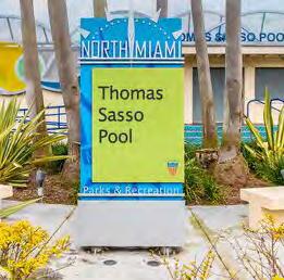
Oleander Park is a part of five diamond-shaped parks in west North Miami. Conversations with residents revealed that these parks were once popular destinations for children and families in the area, equipped with sportsfields and other activities. Presently, three of the five diamond parks are utilized for parks and recreation purposes. The Sunkist Grove Community Center provides a playground and basketball court, the Thomas Sasso Pool, and Kiwanis Park which provides the Youth Education through Sports building, a playground, and open space. The two remaining diamond parks are the Norman Winson Water Treatment Plant and Oleander Park.
The streetscape surrounding the parks is automobile oriented. The roadway directly around the diamond parks measures roughly 20 feet for one-way traffic with no traffic calming elements. This means that cars are likely to speed through the area, endangering the lives of pedestrians and bicyclists. Additionally, cars can be found parked over curbs or on the grass in the area. This leaves less space for pedestrians, as the sidewalks that do exist are often obstructed by vehicles. Signs and other wayfinding mediums are lacking or poorly maintained. The D-PRAT ground team noted multiple signs that are rusting, damaged, or difficult to read.


Focusing on Oleander Park, the park was formerly a baseball or softball diamond. This is conveyed not only through conversations with residents, but also through the baseball/softball backstop and floodlights that are still present in the park. These are the only structures that remain in the park, apart from above-ground utilities and a rusting, damaged chainlink fence that encloses the park. Oleander Park presently is unused and under-utilized, in need of significant improvements to aid the community and City of North Miami.
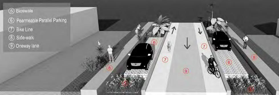
(1) As part of the effort to activate Diamond parks, especially Oleander Park, we propose improving the streetscape so people can walk or bike around and to the four Diamond+ parks. Therefore, the walkability will improve to create opportunities for people to be physically, socially, and mentally healthy. (2) The intent of this network created in the Diamond Parks area will connect to the proposed Bike Boulevard Network. (3) We suggest delineating pedestrian street crossing for safe walking. (4) Add street wayfinding for better orientation of people. (5) (6) As we can see on the existing condition images, people tend to park in green areas; thus, we recommend delineating areas such as green areas and putting in bioswales to infiltrate stormwater runoff from streets and (6) defining parallel parking lots utilizing permeable pavement. (7) (8) (9). Also, add a bike lane, reduce local streets to oneway lanes, and define and fix sidewalks. See images for examples.


In discussions with North Miami residents, there is a desire for a space to gather as a community; Oleander Park can become that space. Features such as site furniture and a covered performing area can be added to facilitate this desire. To further activate the park and increase accessibility, it’s recommended that sidewalks and paved crosswalks are created into and around the park, and that the existing fence is upgraded and maintained. Other elements intended to activate the park include shade trees to protect against harsh sunlight and heat and lighting structures to increase safety and usability of the park at night. The covered performance area and shade trees also increase accessibility and usability by enabling use of the park during extreme heat or rain.
Due to North Miami’s tendency to rainfall flooding and groundwater intrusion, landscaping in the form of rain gardens, bioswale, and alternative planting areas is recommended to mitigate flooding. Additionally, this landscaping adds aesthetic and visual appeal to the park, encouraging residents to use and visit the space.


The park is appropriate to its function, brings people into the park, and is representative of the City of North Miami and its residents. Fences were noted as a staple structure in the City. The fence and gate surrounding Oleander Park should be upgraded to have a design and maintained to avoid rust and extreme signs of wear. The three utility structures should be screened using hedges or opaque fencing to so that users of the park do not need to see them, as these utility structures can be seen as “eyesores.”
As Oleander Park is a part of three other diamond parks (excluding the water treatment plant) design elements should be matched so that the park is recognizable as a part of the diamond park system, and as belonging to the City of North Miami. These elements include features such as signage, site furniture, light structures, and the performing area.


The D-PRAT team looked to the successful transformation of the median on Northeast 135th Street, near The Fairmont House (herein referred to as the “Fairmont House median”), for the activation of Oleander Park. The Fairmont House median was mentioned by a resident as a “passive park” that residents took pride in, and that increased a feeling of community and connectivity with one another. The improvements included a walking path that runs down the middle of the median, seating, trash receptacles, shade trees, and rain gardens. Similar features can be used to reactivate Oleander Park.
The recommended improvements to Oleander Park include sidewalks and walkways, including a walking path through a rain garden, site furniture including benches and tables, a covered performance area, increased landscaping including shade trees and a rain garden, lighting structures, trash receptacles, and defined park entrances. Features such as walkways, site furniture, and defined park entrances activate the park in the simplest manner, by letting users know that this is a space they are welcome in. Entrances can be “defined” by locating signage strategically or using unique elements such as public art to indicate entrances. The major features being recommended are the site furniture and the performance area. These features are the primary elements that will create the gathering area that residents have communicated about. Shade trees are also a feature deemed important to increase protection against heat and sunlight, as City staff has indicated to the D-PRAT team that there has been an increase in heat-related hospitalizations.
Accessibility of Oleander Park must be considered when discussing reactivating the park. It is recommended that paved crosswalks across the roadway and a sidewalk around the park are installed. Paved crosswalks increase pedestrian prioritization on the road and serve as a traffic calming tool, reducing automobile speeds around the park. Parked cars on grass or curbs were noted as a frequent occurrence in the neighborhood. Parallel parking spaces should be provided to accommodate this lack of spaces and number of automobiles used by residents.
North Miami has been noted as being prone to rainfall flooding, groundwater intrusion, and storm surge. To mitigate flooding in Oleander Park, it’s recommended that rain gardens and other planting material that mitigate flooding is used, as well as the installation of a bioswale. Parking space – as mentioned before – and sidewalk and walkway material should be made of impervious material. An additional improvement includes the performance area roof. By slanting the roof, rainfall can fall down the roof into the bioswale.
The passive open spaces the DPRAT team studied are within some of the oldest areas of North Miami. They are framed by Biscayne Canal on the west, Commercial areas on the east along 6th Avenue, the main east west corridor of 125th St. and on the north by the proposed 131st St. east west bike corridor.
The area lies midway between stormwater utilities. As shown in the Zoning map the neighborhood abuts older commercial areas where transitions from single family to commercial by-right zoning is abrupt with little transition except right at the rear property line. These areas behind the businesses are paved parking, storage, loading and trash services which tends to cut off the neighborhood from the main shopping areas and other destinations. The future land use map shows future mixed-use development potential into the neighborhood and should be reviewed for unwanted encroachment.


The passive open spaces were conceived with the original subdivision maps in the 1920’s. They provide welcome breaks in the grid pattern of streets and are centerpieces for the surrounding houses encircling the oblong shaped open spaces. The spaces are usually bisected by streets which separate the two and are rather wide and have large turning radii onto side streets. This promotes speeding and hinders pedestrian safety. The tree canopy in these areas are primarily non-native species.
The current condition of the passive spaces is largely grass with occasional plantings and shrubs to screen some of the utilities. On occasion these spaces are also used by residents for passive use such as dog walking.
The passive open spaces are primarily used to convey utilities, both above and below ground. These utilities have been added over thge decades are were not the original purpose of the open spaces.
Due to the flat topography, extensive amount of asphalt and the compacted soils where vehicles tend to park the open areas of the passive open spaces do not contribute to site drainage. Water tends to frequently pool in low lying areas and can become stagnant.


The existing conditions of the passive open spaces are generally maintained for grass areas only. Existing signage and low posts limit use and access to prevent vehicles from using the area for parking. Surrounding ROW is used for scattered parking and obscures access to the pedestrian passageways at each corner. Several non-native palm trees dot the landscape.


3. Sidewalk/Shared-use path
4. Stream

CALMING MEASURE to slow the speed of traffic while connecting the open spaces and enhancing pedestrian comfort. Green infrastructure such as curb extensions with rain gardens and medians can double as stormwater detention and native plant habitats while improving appearance.

5. Native plants
6. Pathways
7. Open grass
8. Existing/Proposed trees
9. Parallel Parking


Research shows a strong connection to nature is important to our physical and mental health. Biophilic design is an approach that reinforces that connection. The “escape to nature” park concept seeks to allow any stormwater runoff from adjacent roads and houses to naturally weave through the parks as an intrinsic design feature. There are natural pathways that runs parallel to the stream, as well as green spaces with native planting and open grass as picnic and/or seating areas.
Most of the passive open space areas are only serving for utility access and do not provide stormwater retention, active uses or native plantings. As illustrated, these areas can be transformed into beautiful spaces to manage periodic flooding, provide shade and habitat for more bio-diversity. This example shows many Low Impact Development techniques which can mitigate the impacts of stormwater run-off while activating the passive areas..
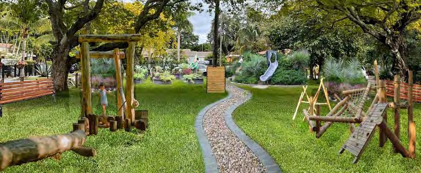
This rendering shows a residential passive park transformed into a children’s oasis. A winding path meanders down the center of the park, with natural wooden playground equipment on either side. On the right toward the rear is a hill formed from soil excavated from the stormwater catchment basins, planted with Florida natives and crowned with a slide. On the left toward the rear is a community garden, consisting of raised vegetable beds in a sunny spot. On either side of the park are bioswales with permeable pavers for parking cars. The bioswales lead stormwater to a series of circular pollinator gardens located between the existing mature trees, beneath which benches offer quiet spots for visitors to rest and contemplate.

1. Speed Table
2. Bioswale/Green Infrastructure
3. Sidewalk/Shared-use path
4. Stream
5. Native plants
6. Pathways
7. Open grass
8. Existing/Proposed trees
9. Parallel Parking


Good Neighbors Stormwater Park is a joint venture between the City of North Miami, the Van Alen Institute, and Urban Impact Lab to transform a flood-prone lot to a usable community space that can retain stormwater and serve as a model for future projects. An international design competition was held, and the winner was the Department Design Office’s “Good Neighbor” design. The park is intended as a pilot for other future similar neighborhood parks and is part of a broader effort to create stormwater resiliency throughout the City.
The park has a retention pond large enough to hold stormwater from 20 surrounding properties, boasts diverse flora from four different local ecosystems, and has a winding path that leads visitors around the pond.
One of our primary recommendations is more regular maintenance to help activate the park and attract visitors while educating residents on the importance of not compacting the soil in the swales adjacent to the park. Cues to care such as trimming plants that encroach on paths, weeding out non-native and invasive plants such as wedelia, maintaining the path, and mulching regularly will signal to the community that this space is valued.
Additional engagement is needed to have more buy-in and support. Based on community feedback, it is presently not highly valued or understood by the residents.


A simple archway can better define the entrance to the park and prepare visitors for a distinct experience.

The bare concrete pad at the entrance could be transformed by a colorful mural, such as an artist’s rendering of a wetland scene or a color block mural created by engaged residents.
Colorful signage that can withstand the elements will educate visitors about the purpose of Stormwater Park and the local ecosystems. Lower, interactive signs can appeal to children, while trilingual signs geared toward adults can go into more scientific detail.

The existing water gauges are fun and colorful, but don’t clearly portray the water depth. New gauges with numerical markings (perhaps paired with the artistic gauges) can better demonstrate the depth of water captured on site.


Stormwater Park contains a wide variety of plant species. Adding a small variety of colorful, flowering plants in dense blocks will provide striking seasonal color.
SCULPTURE
A small, creative sculpture visible from the street would provide visual interest and a source of fun for visiting children

EXISTING CONDITIONS ANALYSIS
The passive parks are bordered on the east and west by NE 2nd Ave and Griffing Blvd, and connect NE 131st St over the Biscayne Canal. The park paths are between four and five feet wide and connect to sidewalks that run along both roads. Both intersections are marked with pedestrian crossings. The current bridge that connects these two parks is narrow and made of metal, with steep steps and a small bike ramp. Currently, both parks sit vacant as grassy plots of land that are unused beyond being maintained by the city. They sit along the 131st Corridor, which this plan is recommending be completely redeveloped as a new multimodal corridor with improved pedestrian and cycling infrastructure. As such, the parks present the perfect opportunity to implement enhanced flood and heat mitigation strategies, while activating an underutilized space for the community and city to use and enjoy.


Excess water will flow into the rain gardens where it is retained and filtered through layers of soil and filtering material.
Maintenance paths will serve as a boundary between two sections of grass, clearly breaking up the landscape while also providing maintenance crews with easier access and pedestrians with a fun path to follow.
More complex bioretention systems can be installed amongst some or all of the rain gardens to directionally remove and sequester water in a specific manner. This could be combined with other design strategies, such as varying the size and placement of the rain gardens to achieve the most effective flood mitigation design.


Bioswales, similar to rain gardens, help capture, absorb, and filter excess water from the streets or the canals. They are built in linear or curved paths, often along curbs and in parking lots, and can be planted with grasses, shrubs, trees, and other vegetation. Local and native plant species should be used. Bioswales should be built to separate the park and the street on both the west and east sides of the park. The bioswales will collect excess water draining from the parks and streets, and using improved treatment design features will enhance the bioswale’s ability to filter pollutants.
Rain Gardens, either with or without bioretention, can capture, absorb, and filter excess water from the canal and streets. They are built as circular or elongated depressions in the landscape that are meant to mimic the natural ways water flows and can be planted with grasses, shrubs, trees, and other vegetation. Local and native plant species should be used.
The design for the parks implements numerous rain gardens spread throughout both parks that are meant to mimic the tree islands of the Everglades. Although the rain gardens are depressed features of the parks compared to raised features in the Everglades, they should be planted with a dense amalgamation of native species that also have beneficial filtering/ treatment characteristics. They will serve as the primary strategy for retaining and filtering excess flood water, while the increase in vegetation will also serve to mitigate urban heat.
Special consideration should be given to increasing the urban canopy of the parks, as this will contribute greatly to mitigating heat and improving the pedestrian experience. In order to accomplish this, additional trees should be planted outside of the rain gardens to provide much needed shade for the path.
The parks should be divided into sections, each planted with a different type of native grass. The sections could either lie along a single elevation or could be raised/lowered so that each section sits at a different elevation than the others. The latter strategy could provide added benefits in more intentionally directing and filtering excess water. The grasses should be divided in a clean and aesthetically pleasing manner, whether in an angular pattern as visualized in this plan, or utilizing a curvier pattern such as Yanweizhou Park, from which this plan took inspiration.
Maintenance paths should be installed to break up the grass sections. Paths should be at least two to three feet wide and made up of a permeable material such as stone or pavers.
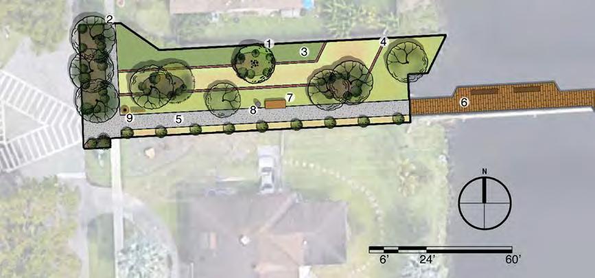
1. Rain Gardens
2. Bioswales
3. Native Grass Sections
4. Maintenance Paths
5. Shared Path
6. Pedestrian Bridge
7. Seating - 7, Lighting
8. Trash, Signage
9. Bike Oasis

The path should be widened to at least 10 feet in order to provide ample space for pedestrians and cyclists of all abilities. Permeable sidewalk material should be installed in place of all existing sidewalks. Materials to be used could be porous asphalt, pervious concrete, or permeable interlocking concrete pavement. Special consideration should be made to choose materials that perform well in hot climates.
A new pedestrian bridge should be installed that will be wider and provide new seating areas for guests to enjoy the park and canal. The new bridge should meet the ADA standards for accessible design, and special consideration should be made to use materials that perform well in hot climates.
Installing new seating areas will provide pedestrians with places to rest and enjoy the park. Special consideration should be made to choose bench materials that perform well in hot climates.
New wildlife-friendly and dark sky compliant lighting should be installed along the path and pedestrian bridge.
New signage should be installed that includes improved wayfinding for the 131st Corridor, as well as educational material that provides information on the risks of a changing climate, such as increased flooding and urban heat, and the strategies that can be used to help mitigate and adapt to them. It is also an opportunity for educative signage on wildlife in the area. This information could be connected to the local context of Florida and discuss how the plants and landscapes of places like the Everglades provide the state and city with numerous benefits. Trash cans with helpful reminders about the benefits of keeping the waterways clean outfitted with sensors when full.
A shaded “bike oasis” should be installed that provides cyclists with bike racks, a pump, and tools. This will provide cyclists utilizing the 131st Corridor with much needed cycling resources.

direction of water flow using slope and swales leading to rain gardens.


Establish a low-stress bicycle network focusing on 131st Street as the primary E/W corridor “spine” with intersecting N/S connections to access other parts of the City

Improve east/west connections under I-95. Focus on 131st Street as the primary E/W opportunity, but could be extended to any of the others. Intention is to re-knit the two parts of the community using the handful of existing connections.


Soften the harsh environment along NW 7th Ave/US-44 for making this corridor feel safer to cross and travel along.
Reclaim swales in residential areas for improved stormwater management.


North Miami's current bike lane network, based on FDOT’s arterial bike lanes, do not meet the public’s need for low-stress bikeable networks. Bicycle Level of Traffic Stress (BLTS) has become the key determinant of whether people ride bikes and how much.
Fortunately, North Miami’s well-connected grid of streets offers a strong framework for building an equitable transportation system that can accommodate driving, biking and walking without extensive, costly modifications.
Establish an east/west and north/south bicycle boulevard through the heart of North Miami. NE131 St street connects the east side to the west under I-95 and over Biscayne Canal pedestrian bridge. Improvements to these key linkages and the design of 131st St. are provided. The north/south link along 8th Ave. provides a pedestrian and bicycle focused corridor to key public destinations such as city Hall, the high school and middle school.
The key to a successful network in North Miami is to build upon the NE/NW 131st Street corridor as one of the City’s new Bike Boulevards. Bike Boulevards are bicycle and pedestrian-priority corridors that put the needs of people biking and walking ahead of cars. 131st Street as the only road that passes beneath I-95 without an interchange as well as the only non-roadway crossing of the Biscayne Canal, naturally lends itself to this designation. No place in the City is more than about ½ mile from this spine.
East of I-95, NE 8th Avenue, connecting the commercial corridor of 125th Street to the High School, public library, the Junior High and Arch Creek Elementary schools, serves as the City’s corresponding north-south Bike Boulevard.
Over time, the City can fill in more of its bicycle network to reach more neighborhoods. Extended to the City boundaries, it can even serve as a framework for adjoining communities to connect their own low-stress bicycle networks to.
This drawing represents Phase 1 with two new bike boulevards through the heart of the city. Phase 2 of the bicycle network will extend access to all neighborhoods, parks and commercial areas within North Miami.


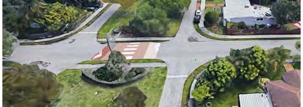
A short trail link will bring the corridor to Arch Creek Road, where a new roundabout provides a safer and easier to navigate alternative to the current collection of awkward lane crossings.
As this concept illustrates, re-designing intersections can make them safer for all modes, reduce speeds and impervious area, cost less to maintain and be more attractive.


Today, the width of this intersection constrains the ability to cross it safely and comfortably. Rebuilding it with a dedicated bike & pedestrian-only crossing2 will improve people’s mobility without adding car traffic.


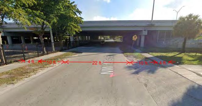
The underpass area where I-95 Expressway goes over NE 131ST corridor is characterized by a 200 feet width overhang coverage of the two-way highway infrastructure with a six-lane expressway on each. The two sides of the NE 131st have some dirt patch and an impervious strip used as a pedestrian walkway. Overall, the underpass area is dimly lit with no artificial light or daylight penetrated from the infrastructure above or reflectors on the concrete surfaces. These conditions make the area unappealing and unsafe. The northern side of the underpass, which is the area adjacent on the westbound 131ST Ave is a large parking lot with a continued overhang of the highway infrastructure. This parking lot appears to be in service of Saint James Catholic Church on the west and the school affiliated with the church on the east. This parking lot, the pedestrian walkways on both sides of 131st Ave, and the road constitute a large impervious coverage and make the highway underpass prone to stormwater flooding in heavy rain.


This section proposes a partial transportation corridor and public space activation for the I-95 Express Highway underpass area where NE131ST Ave intersects.
Among the connectivity and walkability challenges throughout the City of North Miami. One of the concerns the city officials expressed is that the west side of the city remains isolated from the core, and this issue was raised by the communities living there. Indeed, this separation is partially due to the elongated shape of the city territory where the 125th corridor discontinues after intersecting with the NW 7th Ave right west of the I-95 Express Highway. Indeed, the highway creates an edge isolating the west side from the rest of the city because it is both a visual and physical barrier for any modes of movement and transportation in the transverse direction.
As long as I-95 Express Highway infrastructure remains, this effect of I-95 Express Highway could only be remedied by enhancing A sense of connectivity through the highway underpass areas. The underpass at the intersection of NE 131st Avenue presents a good potential for this kind of improvement.
D-Prat team proposes to apply this concept and reactivate the north-side underpass that currently appears to be used jointly as a parking lot by the church and the affiliated school. Our observation on the site suggests this area is seldom used for a parking lot, even though parking space markings suggest that usage. Therefore, a better use of this space could be a play area to be utilized by community members or school-age children as an extended program of the Saint James Catholic Church and the associated school. If the city, department of transportation, and these church and school organizations could reach an governance arrangement, it is conceivable that this space could be used inclusively by all community members with access from the westbound pedestrian walkway of NE 131st Avenue.
NE 131ST Avenue has been one of the focus areas for which the D-Prat team studied. In the D-Prat Team’s planning proposal, NE 131st corridor has been proposed as a bike-path connector between the east and west sides of the city, with the idea of a new bridge over the Biscayne Canal that bike paths can cross. This proposal envisions NE 131ST Avenue accommodating vehicular traffic in both west- and east-bound directions that overlap with bike paths that could be used by both bikes and vehicles alternatingly. This road design continues in the underpass area as well, along with green patches and/or bioswales continuing on both sides. Special consideration could be given to bioswales, and stormwater could be managed along the drainage design between the bike path and the green path strip on both sides.
STORMWATER DRAINAGE DESIGN STRATEGIES


Design Sketch: Public Art concept for surfaces and elements of the underpass area.


1.Bioswales with pedestrian and bike paths
2.Green retaining walls
3.Bioswales by the road
This proposal also envisions activation of the underpass parking lot with a new design combining permeable ground cover, and surface design for community street-games and play area, along with placement of movable play equipment. The new concept for this area as a community play area is inspired by a few other public space activation projects. One of these projects is The Pass, recreational area created in a pedestrian zone below an elevated freeway in San Antonio, Texas. The 8,800 sq ft space underused underpass area near the Market Square in San Antonia, Texas. The Pass reactivates the 8,800-square-foot space, owned by the Texas Department of Transportation (TxDOT), and the concept offers brightly painted and described as an urban gathering space designed for relaxation and play. The Pass includes new lighting, a shaded basketball court, ping pong tables, large picnic tables, wrap-around seating areas, two sets of swinging chairs and long benches. (Source: “Underused underpass near Market Square now an urban recreational space ,“ By Shari Biediger and Raquel Torres, San Antonio Report, August 21, 2023)
Complementary to the 131st Ave road design and activated underpass area, our team proposes a public and environmental art design for highway infrastructure elements. The structural elements of the highway infrastructure, such as structural beams running across the 131ST Ave, columns arrayed along the avenue and repeating in the underpass parking lot area could be painted brighter colors. The installation of wildlife-friendly lighting is a critical aspect of reactivating the underpass area and improving visibility, hence the sense of safety. Additional ideas are bat boxes, green retaining wall and bioswales design for the parts that was originally impervious.


Turning 131st Street into the city’s primary east-west bike & pedestrian can take many forms, depending on the City’s priorities and resources. This series of transformation images show how different streetscape elements can be mixed and matched or built out incrementally over time.

Large canopy trees would not only provide much needed shade, making the corridor more comfortable to use during all hours of the day. But they also create “visual friction” that slows drivers and protects swales by helping to delineate parking areas. Reinforcing the edges of the swales will protect them from compaction by parked cars that reduces their ability to absorb rainwater. Specific sections of swales can be set aside for car parking as needed.

Widening the sidewalks from 4 ft. to 6ft. would vastly increase their functionality. 6ft. will allow two people to easily walk side by side or pass each other without having to step off. It also allows people riding bicycles to use it without forcing pedestrians off the path.

Cars drive down the middle of the pavement except when faced with another oncoming car. To pass each other, both drivers shift over into the bike lane when it’s safe to do so.
Yield streets are a strategy where the extra pavement is typically used for onstreet parking. In this case, it’ll be used for a marked bike lane. These “advisory” bike lanes would be there for those who want to use them. Painting bike lanes green can reduces double parking and other bike lane violations.


Existing Street Condition: NE 137th ST

Proposed Street Section: NE 137th ST


Many of the discussions with residents and staff focused on the high traffic speeds and volumes when I-95 is at a standstill. Residents stated they didn’t always feel safe and would like to see better pedestrian lighting while cyclists were interested in better connections to neighborhood destinations. All agreed there needs to be more shade and pedestrian crossings. Several intersections were noted for a high number of crashes.
DPRAT observers noted the frequency of curb cuts and the use of the shallow parking lots creates several pedestrian and vehicle conflicts. The width and traffic volume on 7th Ave. and the immense scale of I-95 with few physical connections effectively separates the west side of North Miami from the rest of the city.


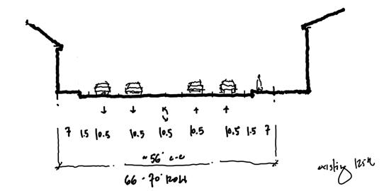
The existing street includes two lanes in each direction with a center turn lane and median. While this is an improvement over the prior condition (three lanes in each direction with a turn lane), the corridor is still dominated by asphalt and vehicles. While the street does include bike lanes that are well marked, these lanes are directly adjacent to high speed travel lanes, discouraging use. Additionally, the corridor lacks sufficient street trees, providing little shade for pedestrians and intensifying the urban heat island effect.

This illustration demonstrates how 7th Ave can be improved without changing the existing curbs. For example, the bike lane is shifted to the curb line and the on-street parking now serves as a buffer to protect bike riders. Extensive street trees have been proposed along the edges of the sidewalk and within the existing median to provide a sense of enclosure and adequate shade for pedestrians and bike riders. Additionally, our team has recommended using the existing building setback area for more pedestrian-oriented uses such as outdoor seating.


Conduct a historic resource survey of historic commercial district and Sunkist Grove neighborhood
Designate commercial area to National Register of Historic Places to take advantage or 20% histoic rehabilitation tax credit and as a local historic district to take advantage of County tax exemption.
Retain historic buildings (or facades at a minimum) to maintain the scale and character of the streetscape while incorporating higher density buildings. Highlight the historic William Bryan School as part of any future transit-oriented development, uncluding redesigning the public sidewalks and fencing.
Explore missing middle housing types as a transition for higher density to single family areas and to provide more diverse housing options.
Develop robust urban design guidelines for streetscapes, infill and new redevelopment. Objective is to increase stormwater capacity, improve the pedestrian experience, provide additional shade and require stepbacks to maintain scale.

Encourage the retention of local businesses in the NW 7th Ave corridor. Incentivize the reuse of parking areas for outdoor cafes, product displays, pop ups and public art


A Historic Resources Survey gathers information on the buildings and history of an area to determine which parts may be eligible for listing on the National Register of Historic Places. This information is the basis for historic preservation planning and allows a community to make decisions to pursue formal historic listing or create strategies to preserve historic structures and neighborhoods.
The Sunkist Grove neighborhood is a post war development that features approximately 2300 homes and apartments with the majority dating from the 1940s to 1970. The community has four parks, a community center and is also the location of the city’s water plant. There are businesses along the periphery of the neighborhood along NW 7th and NW 119th Streets. This area was segmented from the areas of North Miami to the east by the construction of I-95. The area has been recommended as the first residential area for survey because of the unequal investment in this area of the city compared to areas to the east and the potential for deterioration of the building stock. Recognizing the historic significance of an area allows a community to advocate for preservation of its distinct character through a variety of preservation strategies.
Excerpt from Miami Dade County MPO Community Background Reports, “Sunkist Grove,” 01 Jan 2011.
World War II Veterans from Pennsylvania and Iowa relocated to Sunkist Grove (formally known as Westside) in 1947. The “Westside” neighborhood stretched west of I-95 between NW 7th and 17th Avenues and 119th and 135th Streets. As the neighborhood began to grow, large Polish, Italian, and Greek populations migrated from New York. This neighborhood was heavily segregated; once North Miami became a municipality, laws were enacted to keep racial groups segregated. As Miami-Dade segregation laws were dismantled in the mid 1960’s, Sunkist Grove and other North Miami neighborhoods were slow to integrate. For a short period of time, white real estate agents would collectively buy homes from anyone who wished to sell to African Americans as a way to keep the neighborhood segregated. It was not until 1968 that the first African American family, headed by a drug store owner, moved into Sunkist Grove.
Many city officials, including council members and mayors, lived in Sunkist Grove. As the demographic begin to change, the more affluent members of the community moved to the eastside of the city or outside of Miami-Dade County. In 1980, only five percent of residents in this neighborhood were African American. By 1990, the U.S. Census reported 32 percent of residents in North Miami were African American, with many living in the “Westside” community. The area was renamed to Sunkist Grove in 2006. The Sunkist Grove Homeowners Association has been active for almost 25 years, though for the first 20 it was known as Westside Homeowners Association.
North Miami started as a farming community with a stop on Flager’s East Coast Railway at the Arch Creek Railroad Depot. A building boom occurred in the 1920s that was hampered by the depression in the 1930s. After World War II, the city experienced exponential growth and was one of the fastest growing cities in 1951. The commercial district reflects the variety of commercial building types that supported the growing community from the early 1900s through the post war boom of the 1950s and 60s. Survey of the commercial district along NE 125th street and Dixie Highway will assess which buildings and area meet the criteria for listing and allow the city to decide on preservation strategies.


• Improve street scape in front of William J. Bryan School to highlight the historic buildings and provide a welcoming space for the community.The school was built in 1928 and design in the Mediterranean Revival style by architects Robertson and Patterson. It features vaulted ceilings and open corridors surrounding a beautiful courtyard that was designated a historical landmark. The museum students are being inspired to write a book about the restoration and past renovations of the WPA fountain in the center courtyard.
The following recommendation will highlight the historic character of the school.
• Remove chain link fencing and install compatible fencing or walls.
• Increase width of sidewalk to 10 feet (Multi use)
• Construct new fencing or wall that is compatible with the character of the school with planting area in between sidewalk and fencing/wall
• Continue student planting project on the west side of lawn or art project.

Historic Post Office Building (at NE 125th & Dixie Highway)
• Historic Post Office Building ( At NE 125th & Dixie Highway)
• Become part of Main Street Program
• The national Main Street Program is a common-sense, strategy driven framework that guides community-based revitalization efforts. North Miami could build off their existing success by integrating the Main Street approach to promoting the historic commercial core.


NE 125th Street functions as an historic “Main Street” for North Miami. Important civic and cultural buildings are located along it including City Hall, the Museum of Contemporary Art, and the now-vacant historic post office building. The D-PRAT team, along with representatives from North Miami, identified the area around the post office building, at the intersection of NE 125th and W Dixie Highway, to illustrate our urban design and planning goals for the entire downtown core.
Many of these goals were previously identified in the 2013 Downtown Development and Major Corridor Master Plan. The D-PRAT team recommends updating any relevent zoning and urban design guidelines to match these goals as well as those identified on the next page. Once updated, local officials and political leadership should utilize these planning tools to better leverage new private development in making N. Miami’s “Main Street” and downtown core a more walkable and lively destination.


1. Retain historic buildings to maintain the scale and character of the streetscape while incorporating new higher density buildings
2. Explore missing middle housing types as a transition from higher density apartments to single-family homes.
3. Create urban design guidelines for mid- to high-rise development to better integrate with existing context.
4. Incorporate public art throughout including murals and sculpture.
5. Add more trees, green space and infrastructure to manage stormwater runoff and beautify the public realm.
6. Redesign 125th Street as a more walkable Main Street to better connect the downtown core Precedents (from left to right)


- Griffing Gardens: N. Miami example of middle housing, a small-scale 3-story building of townhouse units.
- Liberty Gardens Park: N. Miami example of integrating public space, native lanscaping and a public art mural.
- ChopHouse Row, Seattle: An example of integrating an existing building (previous automobile repair shop) into a new mixed-use development of office, retail and apartments.
- Collection 14, Washington DC: Another example of integrating existing buildings into a mixed-use development, maintaining the human scale and historic character of the existing street.

The surface parking lots at 7th street are unattractive, uncomfortably hot, poorly lit and not well maintained. Many encroach into the public right of way, depriving pedestrians the right to buffer areas, shade and safer sidewalks.
To become a destination for people and businesses on 7th Avenue must transform it into a main street environment with sidewalks that are comfortable and interesting places that encourage people to walk along 7th Avenue and also it will provide lower cost retail, restaurant and service activities which serve local needs.


As an interim measure, we recommend conversion of these areas to outdoor cafes, landscaped buffers and wider sidewalks as also described in Group 2.7th Avenue can adapt over time. In the short term, consider ways to incentivize property owners to clean up and expand the use of these areas with more customer friendly and profitable settings such as outdoor cafes, pop up place-making and food trucks. Outdoor cafés provide activity for many hours of the day and are increasingly seen as business essentials by restaurants. To get started, we recommend adding shade structures to brighten up and protect people from the sun. Add string lights to brighten the mood and improve nightime safety. Close off curb cuts to reduce conflicts and expand the quantity of on street parking. Move the bike lanes close to the curb where it’s safer. Move on-street parking toward travel lane to buffer pedestrians and cyclists.
Any future vision for 7th Avenue should integrate what works today and what it aspires to be as a both a main street for growth, but also a way to stitch back together and reunify the neighborhoods I-95 and 7th Avenue cut off, thus reconnecting the west side to the rest of North Miami. Interim measures such as these both preserve what’s working and what matters as well as help gradually evolve the corridor into a more beneficial future for current residents, businesses, property owners as well as new investors and residents.
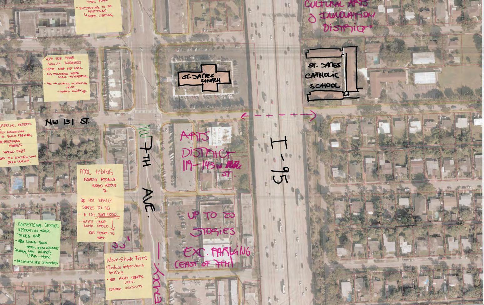
The 7th Avenue corridor has the opportunity to become a center of both new investment and the preservation of lower scale retail buildings and local businesses. These businesses are generally doing well, in part due to their lower rents in older one story buildings. These businesses embody the culture and diversity of North Miami and should be encouraged to remain. The lower scale of these buildings serves as a transition to the single family neighborhoods to the west and preserves a pedestrian scale at the street. During focus group and open house community engagement sessions residents, staff and elected officials expressed a wide range of views. Many were in favor of redevelopment and encourage the city to create an architectural vision. There were suggestions of establishing a cultural arts and innovation district and Chinatown.
The city has zoned the area east of 7th Avenue up to 20 stories, while there is a 55 foot height limit for by-right development on the west side of the street. 7th Avenue is positioned to be a high growth area in the coming decades. Careful attention should be made to preserve the high number of local businesses which embody the character of this diverse community. Every attempt should be made to transition in scale to the adjoining neighborhoods, introduced more housing opportunities and create a complete street, enjoyable for all users.


1. Reconstruct the existing shallow parking lots into one way frontage lanes and encourage activation through lighting, landscaping and "streeteries" - outdoor dining in a parking space.
2. As redevelopment occurs, require a 10' setback to expand the shade, native landscape, stormwater management and pedestrian experience.
3. Rebuild and expand the median to support bio-retention swales, habitat, native plants and shade.
4. Add additional pedestrian crossings along 7th Avenue to facilitate access to surrounding businesses, transit stops and neighborhood destinations.
5. Install curb extensions with green infrastructure to improve pedestrian safety, calm traffic, provide stormwater run-off and shade.
6. Add native species street trees to transform 7th Avenue into a shady, walkable environment to mitigate noise and air pollution and improve appearance.
7. Construct separated bike lanes curbside with on street parking adjacent to traffic.
8. Continue to limit the greatest height and massing to the area between 7th Avenue and I-95.
9. Preserve alleys on both sides for loading, access to parking and a transition to single family neighborhoods.
10. Leverage redevelopment of city fire station site to rebuild station with additional density above.


EXISTING SECTION through NW 7TH AVE. to I-95

Zoning allows up to 35 feet
Zoning allows up to 55 feet
FUTURE SECTION through NW 7TH AVE. to I-95
Zoning allows up to 20 stories
I-95
1. Create urban design guidelines for mid- to high-rise development to better integrate with existing context.
2. Incorporate public art throughout including murals and sculpture.
3. Add more trees, green space and infrastructure to manage stormwater runoff and beautify the public realm.
4. Redesign NW 7th Avenue as a complete street with wide sidewalks a minimum of 15 feet wide including cafe zones, minimum 8 feet clear path, 5 feet wide planters for street trees, 5 feet separated bike lane and on-street parking. The median should be widened and converted to a bio-retention swale with native plantings to provide stormwater retention during flooding and shade during hot summer months.
6. Require 10ft min. stepbacks at 20-25ft and 55ft to establish a pedestrian scale.
7. Establish build-to-lines that require all new development to provide 10 foot setback to improve public realm


Area today includes a mix of apartments and services transitioning to single-family neighborhoods on either side of NE 125th St. Sidewalks are narrow and unshaded, with a lack of connectivity in particular around the train tracks.
A good part of this area is zoned with the North Miami Transit Station Overlay District that allows new buildings up to 200ft tall and residential projects up to 150du/acre.
Proposed TOD station and overlay zoning creates opportunities to enhance multimodal connectivity in this area, bringing people to and from the station, and to stimulate economic, transit-oriented development. The new station platform is expected just north of NE 125th St.


Precedent from Masonic Avenue, SF
Design guidelines and/or standards for new development on streets with existing narrow sidewalks, like NE 125th St, could require public frontage improvements (setbacks or build-to lines) resulting in wider sidewalks (at least 15’) and space for continuous street trees and even shaded, arcaded frontage.
Large and/or consolidated development parcels could require enhanced connectivity through the introduction of new pedestrian streets or paseos when redeveloped, providing enhanced connectivity
Exiting section of 25th street

and increased pedestrian access to the station and to nearby neighborhood amenities.
Large developments could also require the inclusion of new public, or publicly accessible civic space to create new centers of activity in the neighborhood and provide additional capacity for stormwater retention and flood management.
Height reductions or strong regulating lines at 4-6 stories could be considered to help maintain the existing historic scale and character of the area in particular around William J Bryan Elementary School.


The following pages identify key steps to implement the various project ideas presented in this report. Coupled with targeted incentives, phasing can initiate change and showcase early success in key locations. The city should consider implementing some of the low-investment ideas in the public realm as this can serve as a catalyst for future change and will allow the community to understand the impact some of these interventions can have on the long term. For successful implementation of these ideas, initial efforts must focus on the development of partnerships and the securing of potential funding sources.
The following strategies for implementation and sustainability of the plans for the 4 case study areas are recommended by Group 1, in addition to site-specific recommendations made previously in this section.
1. Implement Parkland Fees for Developers to fund ongoing parks maintenance and improvements.
Recognizing the importance of sustainable park development and maintenance, we propose the implementation of parkland fees for developers operating within the City of North Miami. Developers often contribute to the demand for public amenities and green spaces through their projects. Parkland fees serve as a mechanism to ensure that new developments contribute to the enhancement and maintenance of public parks.
Develop a clear and transparent program that requires developers to pay a fee based on the size and nature of their projects. This fee will contribute directly to the improvement, maintenance, and expansion of public parks, aligning with the city’s goals for revitalization and resilience. Define a fair and equitable methodology for calculating parkland fees, taking into account the scale and impact of each development on the demand for public green spaces. Create a dedicated fund specifically for park improvements, ensuring that the collected fees are allocated directly to the enhancement of parks outlined in the revitalization plan.
Communicate the direct benefits of the Parkland Fee Program to the community, emphasizing how the funds will be reinvested in creating vibrant, sustainable, and accessible public spaces. Encourage developers to actively engage in the community’s vision for park revitalization by contributing to the improvement of the local environment. This collaboration can foster a sense of shared responsibility for sustainable urban development. Work closely with developers, city officials, and community stakeholders to ensure that the Parkland Fee Program is transparent, fair, and aligns with the city’s broader goals for park revitalization.
2. Where appropriate, reallocate maintenance responsibilities for these spaces to the City Parks Department in collaboration with City Utilities.
To ensure the ongoing care and vitality of the reimagined public spaces in North Miami, we recommend a thoughtful assignment of maintenance responsibilities. Specifically, where applicable and appropriate, the City Parks Department should assume primary responsibility for the maintenance of these spaces. The Parks Department possesses specialized expertise in maintaining green spaces, landscaping, and recreational facilities. Transferring maintenance responsibilities to this department aligns with the nature of the proposed park revitalization plan and fosters a more cohesive and efficient approach to sustaining these community assets.
Evaluate the type and purpose of each public space to determine the most suitable entity for maintenance. While utilities may still play a role in specific aspects, such as stormwater management infrastructure, the Parks Department should take the lead in overall park upkeep. Collaborate with utility departments where necessary, particularly in cases where stormwater management or other utility-related infrastructure requires joint oversight. Establish clear lines of communication and collaboration to address shared responsibilities.
If needed, invest in capacity building within the Parks Department to accommodate additional maintenance responsibilities. This may include training programs, resource allocation, and recruitment of skilled personnel. Periodically review the effectiveness of the maintenance arrangement, considering feedback from both the Parks Department and utility departments. Adjust responsibilities as needed to optimize maintenance efficiency.
3. Invest in a full-time Arborist on the City staff.
Recognizing the critical role of shade trees in enhancing the aesthetics, environmental benefits, and overall health of city parks and streetscapes, we recommend that the City invest in hiring a full-time arborist dedicated to the care and maintenance of these valuable trees. The designated arborist will be responsible for assessing, monitoring, and ensuring the health of important shade trees within city parks and streetscapes.
Important shade trees, particularly mature specimens, contribute significantly to the urban canopy and environmental resilience. An arborist can implement strategies to preserve and extend the life of these trees. Work collaboratively with city planners and landscape architects to select appropriate tree species for new plantings in parks and streetscapes. Consider factors such as soil conditions, climate resilience, and compatibility with the urban environment. Additionally, an arborist can conduct educational programs and workshops for the community on the importance of trees, proper tree care practices, and the environmental benefits of a robust urban canopy. They could engage with local schools, community groups, and residents to raise awareness about the value of trees and encourage community participation in tree-related initiatives. Finally, the arborist could collaborate with the Parks Department to integrate treerelated activities and educational sessions into community events. Use these opportunities to showcase the significance of trees in the urban landscape.
Investing in a full-time arborist is a proactive measure that reflects the City’s dedication to preserving and enhancing the natural beauty and environmental benefits of its urban landscape.
4. Create a schedule of events in City Parks that invite the community to engage with City staff and public spaces in new and educational ways.
To further enhance community involvement and foster a sense of ownership over the reimagined public spaces, we recommend that the City actively host events in these parks. These events will serve as opportunities for residents to connect, enjoy the transformed spaces, and develop a sense of stewardship.
Organize a series of community events, such as educational programs, picnics, outdoor concerts, art festivals, and recreational activities, to attract diverse demographics. Collaborate with local artists, performers, and community groups to create engaging and inclusive events.
Integrate educational components into events, focusing on the unique features of the reimagined parks. Use these occasions to inform the public about sustainable practices, native plantings, and the significance of stormwater management in enhancing community resilience. Collaborate with local environmental organizations, schools, and experts to provide informative sessions and workshops during events.
Adapt event themes and activities based on the evolving needs and preferences of the community.
Hosting events in the reimagined parks is a powerful strategy to build a sense of community, encourage public participation, and instill a collective responsibility for the well-being of these shared spaces.
1. Create a NW 7th Avenue commercial corridor Zoning Overlay.
a. Eliminate on-site parking requirement for parcels smaller than 10,000sf.
b. Create a commercial reinvestment fund
c. Connect landlords and tenants with professional assistance to incentivize tenants to make their own improvements. This is know as a Percentage Lease:
A percentage lease is a lease agreement where the tenant pays a base rent plus a percentage of their gross sales or revenue. This type of lease is common in retail or hospitality properties, where the landlord wants to benefit from the tenant’s performance and success. A percentage lease can also be used to incentivize tenants to make improvements that increase their sales or revenue, such as expanding their floor space, enhancing their signage, or upgrading their equipment. As a landlord, you can offer a lower base rent or a higher percentage rate to the tenant if they agree to make certain improvements that boost their business and attract more customers. You can also include a clause that allows you to audit the tenant’s sales or revenue records to ensure that they are reporting accurately and paying the correct amount of rent. (Source) https://www.linkedin.com/advice/1/how-can-youstructure-lease-agreement-incentivize-8exzc?trk=public_post_main-feedcard_feed-article-content
2. Designating by Ordinance specific “Bike Boulevard” corridors. (Starting with 131st Street and NE 8th Avenue). Think of them as the public ROW equivalent of a zoning overlay. Bike Boulevards would then be allowed to have their own special traffic operations priorities that are different than the rest of the city or FDOT corridors. These could include:
a. 25mph speed limit
b. No right-on red onto BB streets
c. Increased fees for parking violations
d. Bicycle-priority at all stop signs (ie: “Idaho Stop”)
e. Passive detection at traffic signals
f. Wayfinding signage
3. Consider Tactical Urbanism Projects to enhance existing areas.
FDOT Notable Practices Guide – Provides an overview of tactical urbanism in Miami-Dade County with additional program and design details.
“Tactical urbanism projects illustrate a relatively low-cost countermeasure that relies on community engagement and delivers a visually stimulating outcome with tangible impacts that improve the community. These case examples provided examples of how other agencies can use resources such as the Tactical Urbanism Guide and Toolkit to implement flexible and innovative interventions to local communities’ distinct safety and mobility challenges. There is potential for using such tactical and temporary projects within the planning methodology by measuring the impact of an intervention and using pilot projects as a form of community consultation where citizens can experience a project
instead of being shown a rendering. Agencies should plan to implement such projects on right-of-way that is owned/controlled by the agency for easier access and to potentially avoid a long approval process if there is a time constraint. Finally, hosting community events provides a better understanding of the community needs and leads toward acceptance of long-term implementation of demonstrated efforts.”
and utility costs associated with the project. It can be used on FDOT rights-of-ways but can extend onto adjacent publicly owned property in some instances.
4. Consider Small Scale Infrastructure Interventions at key locations.
Miami-Dade Quick Build Program – An ongoing collaboration of Street Plans, Green Mobility Network, and the Miami-Dade County Department of Transportation and Public Works (DTPW) dedicated to making it easy for citizens to make meaningful improvements to their neighborhoods. In addition to getting infrastructure projects in the ground, the overarching objectives of the program include: empower Miami-Dade County residents to voice their own ideas for transportation projects; form a working relationship with the Department of Transportation and Public Works to enable easier delivery of citizen-proposed projects in the future; and foster partnerships between residents, advocacy groups, agencies, and government entities.
Bloomberg Initiative for Cycling Infrastructure: This grant funding was announced by Global Designing Cities Initiative Grant Program in 2022 and is ongoing. The grant fosters catalytic change in city cycling infrastructures by helping cities implement cycling projects and setting a precedent for what is possible. The grant is mainly designed for cities with 100,000 or more residents who show the capacity for implementing transformative cycling infrastructure improvements.
4. Consider Landscape Beautification at key locations.
FDOT Beautification Grant: https://www.fdot.gov/designsupport/ highwaybeautification/grants.shtm This reimbursable grant can be used for landscape beautification like planting, including soil amendments and irrigation systems. The city would be required to accept all maintenance
Specific subsequent tasks will include updates to the City’s zoning regulations, design guidelines, and other Planning policy documents.The following strategies for implementation are recommended by Group 3:
1. Amend zoning regulations to update the development standards for commercial districts and corridors, such as:
• Maximum building setbacks
• Implementation of Build-To Lines
• Lot frontage standards for all street-facing sides
• Implement architectural design guidelines on all sides of buildings
• Implement appropriate transitioning of building massing and forms
• Sensitivity to and special development standards where adjacent to single-family districts
• Placement of surface parking lots to the rear of buildings
• Multi-modal transportation network improvements
• Pedestrian-friendly amenities such as trees, shade, street furniture, etc. If staff resources are unavailable for this task, retain an architectural firm that has experience with form-based codes to update the zoning regulations.
2. Update lists of uses in the Commercial Districts to be more permissive and encourage mixed uses that are most compatible with residential neighborhoods.
Some of these uses could include retail stores and services, restaurants, personal services, entertainment uses, neighborhood-serving uses, and small-scale offices. They should also include higher density residential or density bonuses. Staff may prepare this update if resources are available, or retain an architectural or planning consultant familiar with mixed uses, form-based codes, or transit-oriented development.
3. Identify a political champion, community leader, or an administrative driver.
Identify a political champion, community leader, or an administrative driver who will push the necessary City actions that will implement the Planning strategy, zoning code changes, budget priorities and transportation system improvements.
4. Develop a comprehensive economic development strategy.
This will help spur industry, job creation, and development that implements the City’s zoning and planning goals. Seek business leaders to participate in and champion strategies to strengthen the economic vitality of the city and empower the private sector to grow from within.
5. As part of economic development, incentivize and attract local developers to bring projects that authentically support North Miami residents and businesses. During new development, seek to retain and enhance the neighborhood’s existing culture and prevent displacement of residents and businesses.
6. As part of economic development, organize a Business Improvement District (BID) or Property and Business Improvement District (PBID).
This will allow to organize private business efforts and raise funds for streetscape beautification and placemaking. Possible locations for a BID or PBID include downtown, the NW 7th Avenue corridor, in the North Miami Transit Station Overlay District, and other corridors identified in the Planned Corridor Development Overlay.
Many of the concepts and recommendations contained in the 2013 Downtown Development and Major Corridor Master Plan remain applicable to the planning area, many of which have been incorporated in the City’s 2036 Comprehensive Plan. The Design-Preservation Rapid Assistance Team strongly concurs with all previous recommended actions contained in the 2013 Downtown Development and Major Corridor Master Plan.
A sample of relevant policies from the 2036 Comprehensive Plan are provided in the table below (note that there are numerous other pertinent Objectives and Policies, but only a few are listed for reference). Adequate policy framework currently exists to achieve the planning vision, but a critical factor for implementation will be continued and persistent efforts by City staff with support from the political leadership. Specific subsequent tasks will include updates to the City’s zoning regulations, design guidelines, and other Planning policy documents that will ensure the community’s vision will be realized.
Objective 1.10
The City shall implement the vision of the Downtown Development and Major Corridor Master Plan as well as the associated Concept and Action Plans by guiding future development and redevelopment within the downtown core and major corridors, and by working in concert with city regulations, visual guidelines, and code compliance to portray its full potential.
Policy 1.10.2
Policy 1.10.3
The City shall examine the current land use and zoning district designation limitations for potential revisions for an enhanced pedestrian-friendly design that encourages people to walk from place to place along major corridors and the downtown.
The City shall incorporate design features into their land development code that include buildto-lines (BTL) for redevelopment, which means that buildings would be built at the edge of the right‐of‐way line and would be more accessible for pedestrians and transit users. Other pedestrian‐oriented design standards that will be considered include wider sidewalks, and streetscaping, such as vegetation for shade and benches for resting, human ‐scale signing, and street lighting.
Policy 1.10.4
Policy 1.10.15
Policy 1.10.16
Policy 1.10.17
Objective 1.16
Policy 1.16.2
The City of North Miami shall create the Planned Corridor Development Overlay, which would be applied to all corridors identified within the Downtown Development and Major Corridors Master Plan. The associated zoning regulations shall outline specific requ irements for building scale, massing, build-to-lines, uses, etc., as detailed in Objective 1.16.
The City should consider land assembly activities and continue façade enhancements along NE 125th Street, West Dixie Highway, and 6th Avenue.
The City shall study the feasibility of increased density and height along major corridors, transit supportive areas and the downtown core.
The City shall explore possible aggregation of land along the downtown corridors and increase the depth of the corridors with land use/zoning changes to provide parcels of sufficient size for redevelopment.
Transitional compatibility zones shall be provided for orderly transition from higher to lower buildings to protect the character of existing single -family neighborhoods outlying new redevelopment, including areas such as the NRO and the Planned Corridor D evelopment (PCD) Overlay.
The Land Development Regulations shall be amended to review parking requirements to reduce for mixed-use buildings that offer bicycle parking and electric charging stations within the NRO and PCD. Land development regulations shall specifically address the reduction. Shared parking between adjoining buildings or off-site parking and centralized parking should be allowed.
Policy 1.16.5
All redevelopment shall be sensitive to the community character enhancement, specifically transit, pedestrian friendliness and the integrity of single-family residences adjacent to the NRO and PCD corridors. Interconnected sidewalks and shade from trees, awnings, canopies or other shading devices are paramount.
Policy
1.17.2
Policy
1.17.3
Mixed-use shall be encouraged along the main corridors within the Neighborhood Redevelopment Overlay, and the Planned Corridor Development (PCD) Overlay. To this end, the land development regulations shall specify ground floor design to accommodate retail, service and entertainment uses and mixed-use parking garages. Upper floors of mixed-use development should contain at least one additional use. All buildings on lots with main corridor frontage should contain at least two fully inhabitable floors.
Mixed-use is required at the five-point intersection/quadrant within the Neighborhood Redevelopment Overlay, wherein ground floor uses shall be limited to commercial retail, service or entertainment, and upper floors shall contain at least one additional u se. All buildings on lots with main corridor frontage shall contain at least two fully inhabitable floors.
Objective
1.18
Policy
2A.6.2
The Planned Corridor Development (PCD) Overlay shall be provided along the following major corridors: the eastern portion of NW 7th Avenue, NE 6th Avenue, NE 125th Street, West Dixie Highway and Biscayne Boulevard excluding those areas on the east side of Biscayne Boulevard, as depicted on the Future Land Use Map. The PCD will create a compact, high-intensity mix of residential, commercial, employment, and civic/institutional uses to maximize the use of transit, reduce the use of single -occupancy vehicles, increase pedestrian activity, and improve access and mobility. The policies in this objective encourage an eventual update to the land development code that will implement a more intense and efficient use of land, with increased densities, to promote the mutual reinforcement of public investments and private development of land.
The City will implement the recommendations of the 2005 Transportation Master Plan and Downtown and Major Corridors Master Plan (2013).and include improvements for the pedestrian environment in the City’s Capital Improvement Plan.
Policy
2C.1.4
Policy
3A.3.3
The City shall implement the recommendations of the City of North Miami Transit Oriented Development (TOD) Feasibility Study (2005) and Downtown Development and Major Corridors Master Plan (2013). The City will designate specific geographic areas within th e City as TOD districts. The City will create Transit Oriented Design projects. The City will include transit supportive strategies into its Land Development Regulations and coordinate with MiamiDade Transit, the Office of Public Transportation Management and the MiamiDade County MPO to ensure adequate transit service is focused in TOD districts. Ideally, these TOD districts would evolve into having a 24-hour presence by providing housing; capitalizing on City assets; strengthening existing retail, restaurants, and cultural activities; incorporating parks, plazas, and pedestrian friendly corridors; promoting a diversified retail mix; and promoting livable and complete streets (bike lanes/ on-street parking/ pedestrian friendly/ shaded trees/ awning/ etc.) to encourage use beyond working hours and create a sense of place within the community.
The City shall implement a historic preservation program for the preservation of units identified in the City’s inventory of significant housing and establish land development regulations to guide the preservation, rehabilitation and demolition of historically significant housing units.