WESTERN

INFORMATION MEMORANDUM.
HEAD OFFICE 18-20 Russell St, Melbourne SOUTH EASTERN OFFICE 2 Brandon Park Dr, Wheelers Hill
EASTERN OFFICE Suite 2, 5 Corporate Blvd, Bayswater
OF INTEREST:
OFFICE Suite 102, 3 Little Boundary Rd, Laverton North POINT
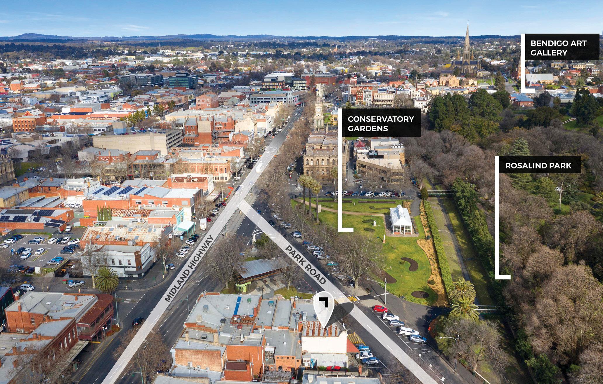
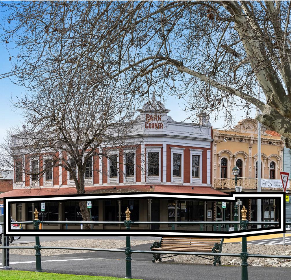
Park Corner, 4-10 Howard Place, Bendigo.
CONTENTS 01 POINT OF INTEREST 02 POINT OF VIEW 03 PROPERTY FEATURES 04 LOCATION 05 CITY PROFILE 06 PROPERTY PARTICULARS 07 CONTACT DETAILS 08 APPENDICES ▪ FLOOR PLAN ▪ TITLE PLAN ▪ ZONING AND PLANNING OVERLAYS

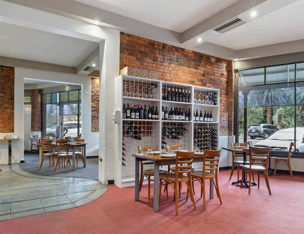
01 4-10 HOWARD PLACE, BENDIGO INFORMATION MEMORANDUM WWW.CVA.MELBOURNE 01 POINT OF INTEREST PARK CORNER, 4-10 HOWARD PLACE, BENDIGO. BUILDING AREA 700 sqm* LAND AREA 544 sqm* ZONING Commercial 1 zone TENANCY Ground floor - FOS Kitchen & Bar First floor - Vacant possession METHOD OF SALE Private Sale SALE TERMS 10% deposit, balance 60/90 days
02 POINT OF VIEW
— DANIEL PHILIP DIRECTOR - SOUTHERN REGION
Bendigo’s history and deep cultural heritage is a big part of the region’s strength. These iconic buildings are a major part of the region’s history.
Two iconic, two-level freehold buildings positioned in the heart of Bendigo.

Irreplaceable corner location overlooking the Conservatory Gardens and the magnificent 60 acre Rosalind Park.
Historic buildings over 100 years old.
Located 100 metres from the Visitor Information Centre, ready to direct business to your door.
Bendigo Train Station is walking distance from the property, through the CBD.
The rear land is capable of 8 on-site car spaces.
Convenient Midland Highway position.
JOHN NOCKLES DIRECTOR - AGENCY
02 4-10 HOWARD PLACE, BENDIGO INFORMATION MEMORANDUM WWW.CVA.MELBOURNE
“Park Corner, an historic Bendigo freehold with buildings that present an array of options for you to reimagine and redefine their legacy.”
“With ground floor income and a vacant first floor this is one of the best repositioning assets Bendigo has seen.”
03 PROPERTY FEATURES
IMPROVEMENTS
The current improvements comprise 700 sqm* and feature a 46.3 metre* frontage.
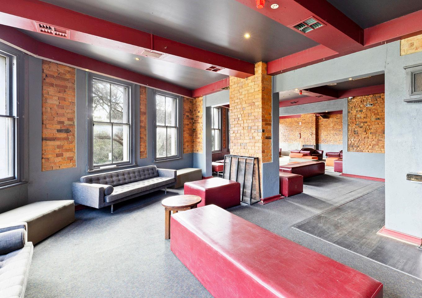
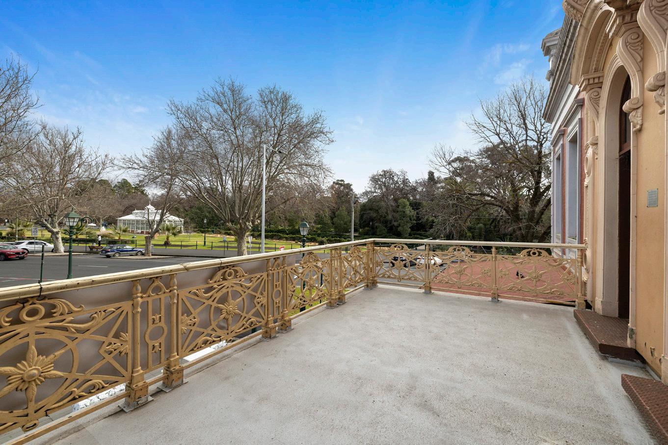
The ground floor is a 350sqm* fully fitted restaurant with commercial kitchen and dual separate entrances and the first floor a 350sqm* open space area with front and rear access and a magnificent 35sqm* balcony overlooking the Conservatory gardens and Midland Highway.
AND THE POINT?
It took a century for the chance to get Bendigo’s best. Only bound by your ambition, we’re imagining repurposing these premium two storey corner buildings with private balcony, overlooking the palms and ferns of Conservatory Gardens, into one of Bendigo’s most talked about venues.
03 4-10 HOWARD PLACE, BENDIGO INFORMATION MEMORANDUM WWW.CVA.MELBOURNE
35 sqm* cast-iron balcony overlooking the Conservatory gardens and 60 acre Rosalind Park.
First floor previously occupied for 17years as Bendigo’s best nightclub.
LOCATION
ALL SIGNS POINT TO: BENDIGO.
These historic buildings, known as “Park Corner” at 4–10 Howard Place, are in a prized location in the centre of town.
The corner draws a high volume of foot traffic being surrounded by major tourist attractions including the famous Bendigo Art Gallery, Golden Dragon Museum, Historic Talking Tram Tours and the adjoining new Vintage and Classic Motorbike Museum.
The property overlooks Bendigo’s premier Rosalind Park, noted for its historic trees, statues, magnificent buildings and landscapes that are reflective of Bendigo’s golden past.
Rosalind Park also attracts tourists, locals and garden lovers to visit its imposing Lookout Tower, the Victorian Fernery with water features and the ancient river red gums of historical significance.
Within Rosalind Park is The Conservatory Gardens featuring an ornate 19th century glass Conservatory building with rose gardens and heritage sculptures. Erected in 1897, it is the last building of its type in a public park in Victoria, with magnificent foliage and floral displays on show throughout the year. A major highlight is the annual Tulip festival attracting hundreds
to the area to enjoy seeing more than 50,000 tulips in bloom and an annual Spring Festival to celebrate the event.
Park Corner is footsteps from Bendigo’s Arts and Theatre precinct housing not only the renowned Bendigo Art Gallery, but also two major live performance and concert venues with 120+ major events annually. The city offers a broad range of dining and is the first of only two cities in Australia to be honoured as a” UNESCO Creative City of Gastronomy”.
The city of Bendigo is connected to Melbourne and other regions by high-quality road and rail infrastructure. The property is conveniently located on Midland Highway, which is the main arterial that takes you into Melbourne’s centre in under two hours. In terms of public transport, bus routes are within arm’s reach and can take you straight to Bendigo railway station, getting you directly into Melbourne on one line.
Bendigo airport (recognised in 2019 as Victoria’s Best Regional Airport), has daily flights directly in and out of Sydney, with the airport expansion project currently underway due for completion in the second half of 2023.
04 4-10 HOWARD PLACE, BENDIGO INFORMATION MEMORANDUM WWW.CVA.MELBOURNE
04
LOCATION
ALL SIGNS POINT TO: BENDIGO.
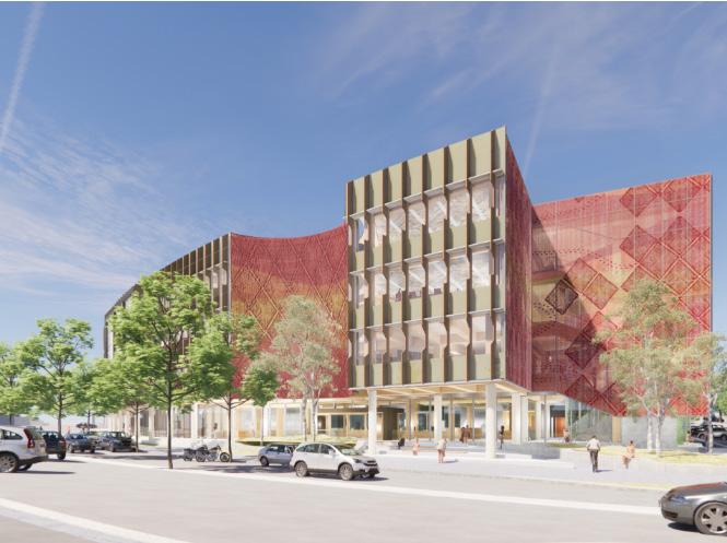
Under construction approximately 50 metres away from Park Corner, 4-10 Howard Place, is a brand new, state-of-the-art GovHub building. This unique, four storey building is a one-stop-shop for community services and a hub for the local community. It will be home to 2000 government employees in 2023.
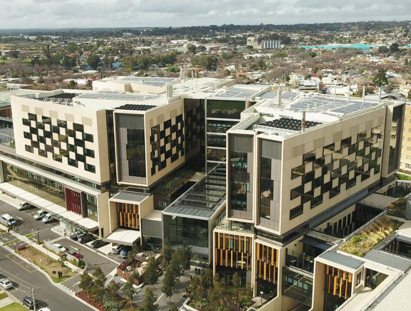
Park Corner, 4-10 Howard Place, is close to Bendigo’s health precinct, including Bendigo Hospital (pictured), which has had the largest regional hospital development in Victoria with $630 million spent on state-of-theart construction.
05 4-10 HOWARD PLACE, BENDIGO INFORMATION MEMORANDUM WWW.CVA.MELBOURNE
04
05 CITY PROFILE
ON THE MAP: BENDIGO.
Situated about 150km northwest of Melbourne, Bendigo is the third-most populous city in regional Victoria and an important city for the central Victorian economy.
Bendigo is one of Australia’s fasted growing regional cities, with a population set to reach 200,000 by 2050 (400,000 in the wider region). It is Victoria’s third largest urban economy, with more than $400 million in new government building investment confirmed.
Bendigo, voted VICTORIA’S TOP TOURISM TOWN IN 2022, draws millions of visitors each year with its trove of gold rush era architecture and numerous art and cultural festivals, including those celebrating Bendigo’s large Chinese community especially at Easter and Chinese New Year.
As the largest regional centre in the Loddon Mallee region, the city is expected to experience a relatively high growth rate compared to other parts of the region and regional Victoria as a whole.

Bendigo Art Gallery is known as Australia’s best regional art gallery, with a reputation for delivering internationally recognised block buster exhibitions. Most recently, Elvis: Direct From Graceland saw 219,000 attendees, 80% were from outside of Bendigo.
Bendigo is one of regional Victoria’s most progressive and contemporary cities and is located in the heart of the Goldfields region.
Greater Bendigo is a great place to live and invest. It is a highly liveable, growing regional centre with nearly 2,000 additional people calling Greater Bendigo home every year.
FUTURE GROWTH.
Voted Victoria’s Top Tourism Town in 2022, Bendigo will also be host to a number of events for the 2026 Commonwealth Games.
By 2030 more than 140,000 people will be calling Greater Bendigo home. The city will have a notable track record. It will be renowned for a strong, robust, innovative and diversified workplace that creates long term jobs.
The Strategy’s vision for 2030 is to ‘shape an inclusive, sustainable and prosperous community where all people can thrive’.
The plan is for Greater Bendigo to be much more widely recognised as a great liveable city. By 2030 Bendigo will have built further on their strengths, be more known nationally and globally for welcoming and caring for all and are living sustainably within our environmental setting.
The $400 million of State Government investment in community and business facilities in the next three years will further consolidate the city centre’s role and add further jobs.
The City of Greater Bendigo has secured all funds to complete the City of Greater Bendigo’s priority project, the expansion of the Bendigo Airport terminal and adjoining business park of 21 lots. It is expected that the project will support 49 jobs during the construction phase and create five full times jobs in the first year of operation and up to 19 jobs by 2030.
06 4-10 HOWARD PLACE, BENDIGO INFORMATION MEMORANDUM WWW.CVA.MELBOURNE
SOURCES: A STRONGER GREATER BENDIGO, EDCONOMIC DEVELOPMENT STRATE GY 2020-2030, BENDIGO.VIC.GOV.AU, BENDIGO TOURISM
Bendigo Art Gallery
KEY HIGHLIGHTS AND INDUSTRIES OF BENDIGO AS AT FEBRUARY 2020
Total output: $16.691 billion
Tourism output: Estimated at $297.568 million
Number of jobs: 47,905
Key industries: Manufacturing, Construction, Financial and Insurance, rental, hiring and real estate services.
Gross Regional Product total: $7.503 billion
1.3 million overnight visitors. (92% growth over the past 10 years)
2.6 million visitor nights. (89% growth over the past 10 years)
3.2 million day trip visitors. (42% growth over the past 10 years)
Recent facts show that the median age for home occupiers is 43 years and the median household size is 2.4 people. The average number of bedrooms per occupied private dwelling is 3.2. 92.3% occupy a separate house in this suburb and 6.3% are semi-detached.
MEDIAN RESIDENTIAL PRICES
07 4-10 HOWARD PLACE, BENDIGO INFORMATION MEMORANDUM WWW.CVA.MELBOURNE 05
$1,164
CITY PROFILE FAMILY HOUSEHOLD INDIVIDUAL WEEKLY INCOME $1,432
100% 5,652 RESIDENTS 20.6% 1,163 RESIDENTS 66.5% 3748 RESIDENTS 12.9% 726 RESIDENTS BETWEEN 15-65 UNDER 15 OVER 65 POPULATION $577,500.00 $705,000.00 HOUSE UNIT
SOURCES: A STRONGER GREATER BENDIGO, EDCONOMIC DEVELOPMENT STRATEGY 2020-2030, PROPERTYDATA.COM.AU, AUSTRALIAN BUREAU OF STATISTICS, CENSUS 2021, REMPLAN.COM.AU
$729
04 CITY PROFILE
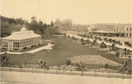
HISTORY OF BENDIGO.
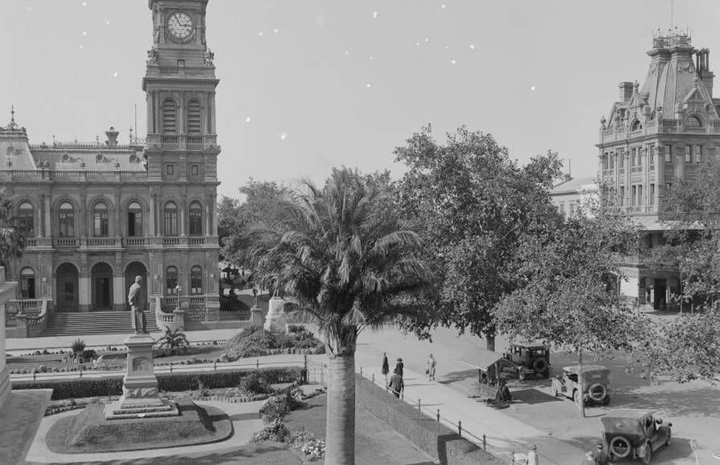
Conservatory Gardens (1899) Looking directly at 4-10 Howard Place, Bendigo.
Charing Cross, Soldiers Memorial Institute Military Museum and Pall Mall (1945)
The Conservatory Gardens features an ornate 19th century Conservatory building, rose gardens and heritage sculptures. The Conservatory building was erected in 1897 and is the last building of its type in a public park in Victoria. A highlight is the floral and foliage displays that are on show throughout the year, including the spring tulip display.
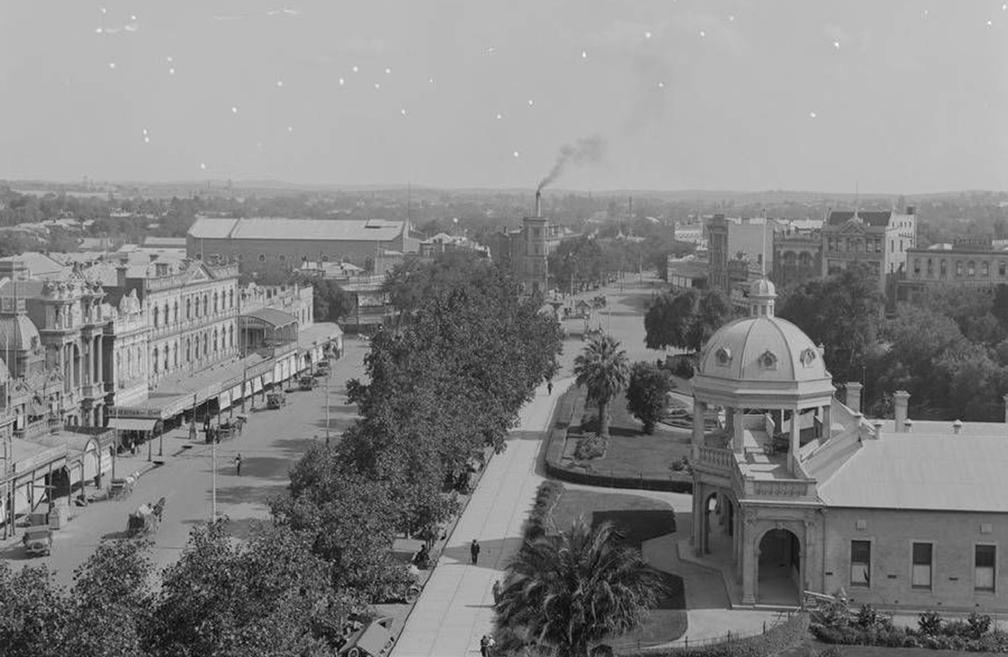
Charing Cross is a major junction centrally located in the city of Bendigo. It stands at the busiest and most prominent intersection of four of Bendigo’s main streets: High Street, View Street, Pall Mall and Mitchell Street.
Soldiers Memorial is a significant landmark both for the residents of the City of Greater Bendigo and for visitors. The Museum was recently redeveloped and officially reopened on November 15 2018, exactly 97 years after the initial opening of the building in 1921.
Pall Mall, featuring Shamrock Hotel and old post office (Date unknown)
Pall Mall is one of the main streets of the Bendigo central business district. It forms a 500-metre section of the Midland Highway, one of Bendigo’s main thoroughfares.
Since the 1860s, Pall Mall has been regarded as “one of the most charming thoroughfares in Australia” and the collection of Victorian-era buildings in the Second Empire architectural style, gardens and statuary either side of the wide tree-lined streetscape is unparalleled in regional Victoria.
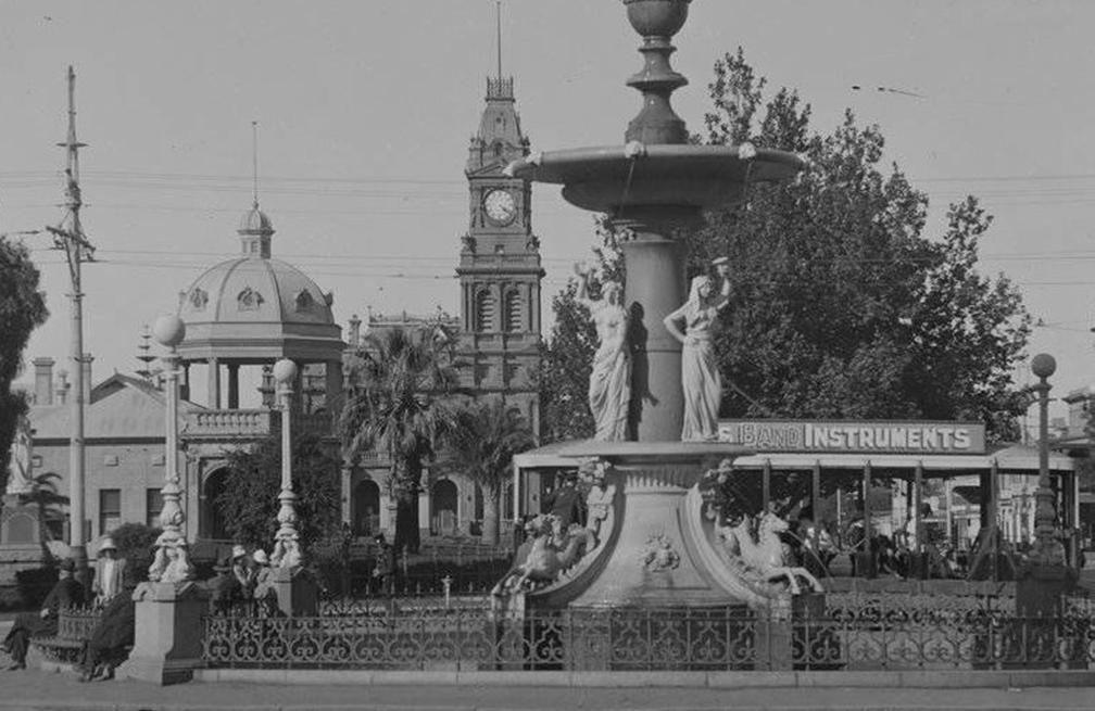
Alexandra Fountain in the Australian city of Bendigo, Victoria, is regarded as one of the city’s most prominent landmarks and monuments. The fountain was named in honour of Alexandra, Princess of Wales. It is the largest and most ornate municipal fountain in Victoria.
08 4-10 HOWARD PLACE, BENDIGO INFORMATION MEMORANDUM WWW.CVA.MELBOURNE
Alexandra Fountain (1920-1954)
PROPERTY PARTICULARS
PRINCIPLE OUTGOINGS
SITE DETAILS
Council rates: $2,101.70 per annum*
Water rates: $4,547.08 per annum*
Land tax: $835.00 per annum*
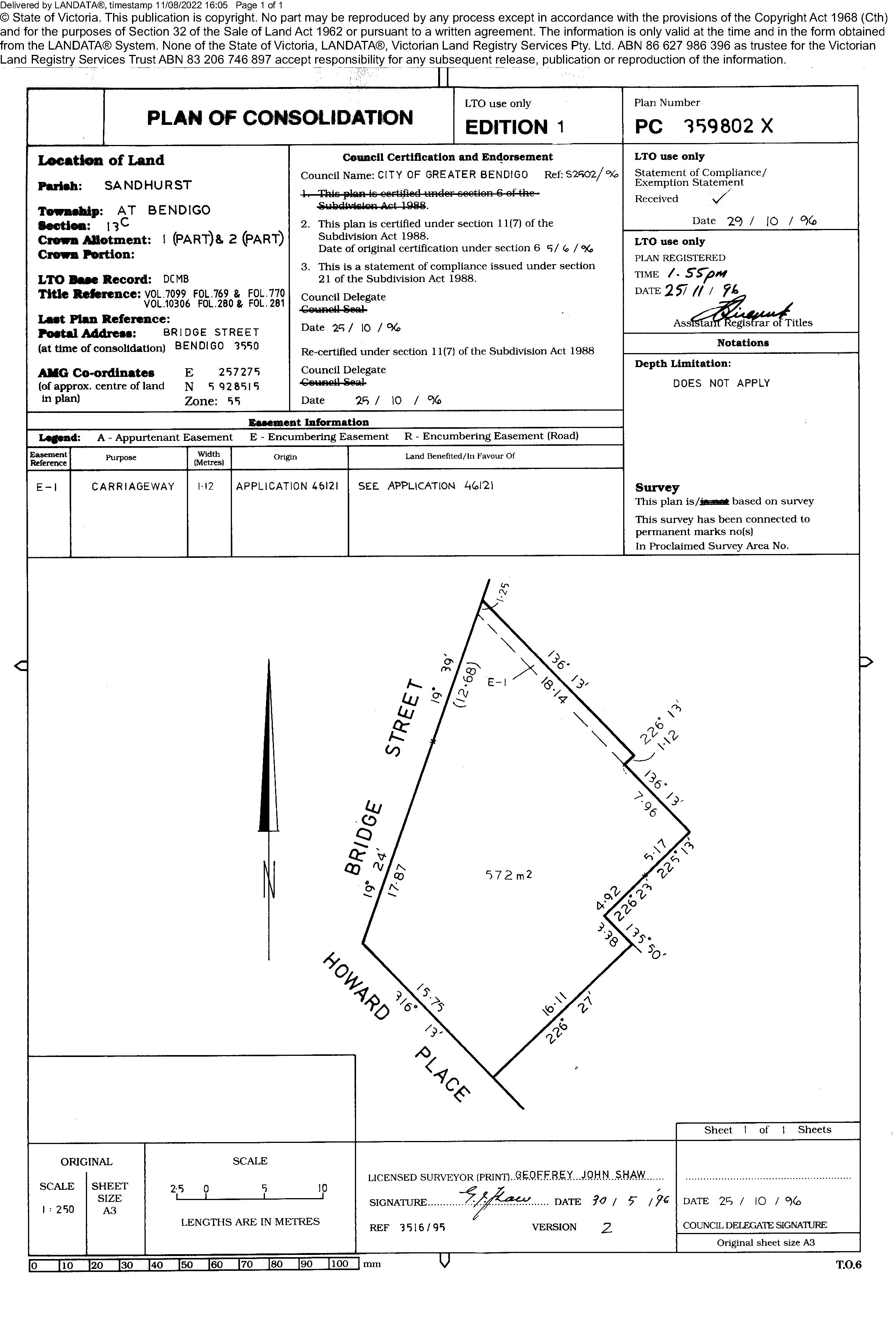
Frontage to Park Road: 31.2 metres*
Frontage to Howard Place: 13.9 metres*
Eastern side boundary: 28.7 metres*
Southern side boundary: 26.7 metres*
Total site area: 544.00 square metres*
TITLE PARTICULARS
Certificate of Title — Volume 10307 Folio 789
ZONING
Commercial 1 Zone (C1Z)
PLANNING OVERLAYS
Design And Development Overlay — Schedule 5 (DD05
Heritage Overlay (Ho160)
Land Subject To Inundation Overlay - Schedule 1 (LS1O1)
Parking Overlay - Precinct 1 - (PO1)
09 4-10 HOWARD PLACE, BENDIGO INFORMATION MEMORANDUM WWW.CVA.MELBOURNE
06
FOS KITCHEN & BAR

A short stroll from shady Lake Weeroona Park is Bendigo’s authentic Greek destination FOS Kitchen & Bar. Inside, a rustic setting of exposed brick, tiled floors and spacious arches provide a trendy backdrop for the inner-city foodies and new visitors that come looking for flavoursome, traditional Greek and Mediterranean fare.
10 4-10 HOWARD PLACE, BENDIGO INFORMATION MEMORANDUM WWW.CVA.MELBOURNE TENANT FOS Kitchen and Bar
RENTAL $65,000.00 p.a. + outgoings per lease LEASE TERM Three (3) years FURTHER TERM
DATE
RENTAL REVIEWS Annual CPI OUTGOINGS Payable by tenant as per lease TENANCY DETAILS
CURRENT
Further term of four (4) years, commencing October 2022 COMMENCEMENT
20 October 2013
06 PROPERTY PARTICULARS
DETAILS
PHILIP DIRECTOR
POINT OF INTEREST:
An agent that turns first impressions into lasting commitments. Since the early days of his career, Daniel has established a level of service that is defined by in-depth market knowledge, expert advice and responsive communication. Committed to creating value in the commercial real estate opportunities he matches with his clients’ objectives, and the ability to think outside the square. Especially if that extends well beyond Melbourne’s inner-city grid.

- SOUTHERN REGION
POINT OF VIEW:
“Commercial real estate is underpinned by longevity. In the loyal client partnerships we establish and the value we create on a trusted basis, it’s a partnership that starts here, but sees each individual reach their own objectives.”
NOCKLES DIRECTOR - AGENCY
POINT OF INTEREST:
John’s experience in commercial real estate is now pushing a decade and over that time he’s proud to see change when it comes to property in Melbourne. By adopting a lateral approach within a linear industry, John understands success within Melbourne’s commercial real estate market occurs by looking beyond what has been done, to what can be. It’s an approach that mirrors this city’s originality, commercially—and with it, creativity that extends beyond St Kilda Road.
POINT OF VIEW:
“The Melbourne commercial property market has always been about rationale in dollars and cents. But, when working with rising land values and changes in the way that occupiers use commercial property, the market now requires those that will help shape it to be more creative than ever.”

11 DISCLAIMER: THIS REPORT HAS BEEN COMPILED ON THE BASIS OF INFORMATION AVAILABLE. THOUGH EFFORTS HAVE BEEN MADE TO VERIFY OR ESTABLISH THE ACCURACY OF THE MATERIAL, IT IS NOT POSSIBLE TO WARRANT THAT IT IS ACCURATE. SOME PREDICTIONS ARE ESTIMATES ONLY AND NECESSARILY BASED ON ASSUMPTIONS WHICH MAY NOT OCCUR. ALL PARTIES SHOULD MAKE THEIR OWN INDEPENDENT ENQUIRIES WITH REGARD TO ALL THE INFORMATION CONTAINED IN THIS REPORT. THE REPORT IS INTENDED TO BE GENERAL INFORMATION ONLY AND WILL NOT FORM PART OF ANY CONTRACT NOR IS IT TO BE TAKEN AS ANY FORM OF ANY REPRESENTATION, WARRANTY OR INDUCEMENT. THE AGENTS AND REPRESENTATIVES DO NOT ACCEPT ANY RESPONSIBILITY FOR AND WILL NOT BE LIABLE IN RESPECT OF ANY OF THE CONTENTS OF THIS REPORT. *APPROXIMATELY 4-10 HOWARD PLACE, BENDIGO INFORMATION MEMORANDUM WWW.CVA.MELBOURNE 07 CONTACT
M: 0439 977 121
DANIEL
M: 0404 530 393
E: daniel.philip@cva.melbourne
JOHN
E: john.nockles@cva.melbourne
12 4-10 HOWARD PLACE, BENDIGO INFORMATION MEMORANDUM WWW.CVA.MELBOURNE 08 APPENDICES
4-10 HOWARD PLACE, BENDIGO WWW.CVA.MELBOURNE
FLOOR PLAN
4-10 HOWARD PLACE, BENDIGO WWW.CVA.MELBOURNE
TITLE PLAN
ZONING & PLANNING OVERLAYS
4-10 HOWARD PLACE, BENDIGO WWW.CVA.MELBOURNE
34.01 31/07/2018 VC148
COMMERCIAL 1 ZONE
Shown on the planning scheme map as B1Z , B2Z , B5Z or C1Z
Purpose
To implement the Municipal Planning Strategy and the Planning Policy Framework.
To create vibrant mixed use commercial centres for retail, office, business, entertainment and community uses.
To provide for residential uses at densities complementary to the role and scale of the commercial centre.
Operation
A schedule may apply under this zone to a planning scheme outside of metropolitan Melbourne. That schedule may: specify the maximum leasable floor area for office
■
34.01-1 26/05/2020 VC175
■ specify the maximum leasable floor area for shop (other than restricted retail premises).
Section 1 - Permit not required
Table of uses Use
Accommodation (other than Community care accommodation, Corrective institution and Rooming house)
Art and craft centre
Child care centre
Condition
Any frontage at ground floor level must not exceed 2 metres (other than a bed and breakfast and caretaker's house).
Any frontage at ground floor level must not exceed 2 metres and access must not be shared with a dwelling (other than a caretaker's house).
Cinema
Cinema based entertainment facility
Community care accommodation
Any frontage at ground floor level must not exceed 2 metres.
Must meet the requirements of Clause 52.222.
Education centre (other than Child care centre)
Exhibition centre
GREATER BENDIGO PLANNING SCHEME
Page 1 of 8
Use Condition
Home based business
Informal outdoor recreation
Office
Place of worship
Railway
Retail premises (other than Shop)
Rooming house
Shop (other than Adult sex product shop)
Tramway
The leasable floor area for all offices must not exceed any amount specified in the schedule to this zone.
The gross floor area of all buildings must not exceed 250 square metres.
Any frontage at ground floor level must not exceed 2 metres.
Must meet the requirements of Clause 52.232.
The leasable floor area for all shops must not exceed any amount specified in the schedule to this zone.
Any use listed in Clause 62.01 Must meet the requirements of Clause 62.01.
Section 2 - Permit required
Use Condition
Adult sex product shop
Must be at least 200 metres (measured by the shortest route reasonably accessible on foot) from a residential zone or, land used for a hospital, primary school or secondary school or land in a Public Acquisition Overlay to be acquired for a hospital, primary school or secondary school.
Agriculture (other than Animal production and Apiculture)
Grazing animal production
Industry
Must not be a purpose listed in the table to Clause 53.10.
GREATER BENDIGO PLANNING SCHEME
Page 2 of 8
Use Condition
Leisure and recreation facility (other than Informal outdoor recreation, Major sports and recreation facility and Motor racing track)
Place of assembly (other than Carnival, Cinema, Cinema based entertainment facility, Circus, Exhibition centre and Place of worship)
Utility installation (other than Minor utility installation and Telecommunications facility)
Warehouse
Any other use not in Section 1 or 3
Section 3 - Prohibited
Use
Must not be a purpose listed in the table to Clause 53.10.
Must not be a purpose listed in the table to Clause 53.10.
Animal production (other than Grazing animal production)
Corrective institution
Major sports and recreation facility
Motor racing track
34.01-2
15/07/2013
VC100
Use of land
A use must not detrimentally affect the amenity of the neighbourhood, including through the:
■
Transport of materials, goods or commodities to or from the land.
■
34.01-3
31/07/2018
VC148
■
Appearance of any building, works or materials.
Emission of noise, artificial light, vibration, smell, fumes, smoke, vapour, steam, soot, ash, dust, waste water, waste products, grit or oil.
Subdivision
A permit is required to subdivide land.
VicSmart applications
Subject to Clause 71.06, an application under this clause for a development specified in Column 1 is a class of VicSmart application and must be assessed against the provision specified in Column 2.
GREATER BENDIGO PLANNING SCHEME
Page 3 of 8
Class of application
Subdivide land to realign the common boundary between 2 lots where:
■
The area of either lot is reduced by less than 15 percent.
Information requirements and decision guidelines
Clause 59.01
■
The general direction of the common boundary does not change.
Subdivide land into lots each containing an existing building or car parking space where:
■
The buildings or car parking spaces have been constructed in accordance with the provisions of this scheme or a permit issued under this scheme.
Clause 59.02
■
An occupancy permit or a certificate of final inspection has been issued under the Building Regulations in relation to the buildings within 5 years prior to the application for a permit for subdivision.
Subdivide land into 2 lots if:
■
The construction of a building or the construction or carrying out of works on the land:
■
■ Has started lawfully.
Has been approved under this scheme or by a permit issued under this scheme and the permit has not expired.
The subdivision does not create a vacant lot.
■
Buildings and works
Clause 59.02
A permit is required to construct a building or construct or carry out works. This does not apply to:
The installation of an automatic teller machine.
■
■
An alteration to an existing building façade provided:
The alteration does not include the installation of an external roller shutter.
■
■
■
At least 80 per cent of the building facade at ground floor level is maintained as an entry or window with clear glazing.
An awning that projects over a road if it is authorised by the relevant public land manager.
An apartment development must meet the requirements of Clause 58.
VicSmart applications
Subject to Clause 71.06, an application under this clause for a development specified in Column 1 is a class of VicSmart application and must be assessed against the provision specified in Column 2.
GREATER BENDIGO PLANNING SCHEME
34.01-4 31/07/2018 VC148
Page 4 of 8
34.01-5 16/01/2018 VC142
Class of application Information requirements and decision guidelines
Construct a building or construct or carry out works with an estimated cost of up to $500,000 where the land is not:
■
Within 30 metres of land (not a road) which is in a residential zone.
■
■ Used for a Brothel or Adult sex product shop.
Used for a purpose listed in the table to Clause 53.10.
Clause 59.04
34.01-6 01/07/2021 VC203
Transitional provisions
Clause 58 does not apply to:
■
An application for a planning permit lodged before the approval date of Amendment VC136.
■ Maintenance
An application for an amendment of a permit under section 72 of the Act, if the original permit application was lodged before the approval date of Amendment VC136.
All buildings and works must be maintained in good order and appearance to the satisfaction of the responsible authority.
Neighbourhood and site description and design response
An application for any of the following must be accompanied by a neighbourhood and site description and a design response as described in Clause 54.01 or 55.01, as appropriate:
■
Construction or extension of one dwelling on a lot of less than 300 square metres.
■
■
Construction of a dwelling if there is at least one dwelling existing on the lot.
Construction of two or more dwellings on a lot.
■
■
Extension of a dwelling if there are two or more dwellings on the lot.
Construction or extension of a dwelling on common property.
■
Construction or extension of a residential building.
Clause 34.01-5 does not apply to an apartment development.
Satisfactory neighbourhood and site description before notice and decision
If the responsible authority decides that the neighbourhood and site description is not satisfactory, it may require more information from the applicant under Section 54 of the Act.
The responsible authority must not require notice of an application to be given or decide an application until it is satisfied that the neighbourhood and site description meets the requirements of Clause 54.01 or 55.01 and is satisfactory.
This does not apply if the responsible authority refuses an application under Section 52(1A) of the Act.
Application requirements
GREATER BENDIGO PLANNING SCHEME
Page 5 of 8
Use
An application to use land must be accompanied by the following information, as appropriate:
■
The purpose of the use and the types of activities which will be carried out.
■
■
The likely effects, if any, on adjoining land, including noise levels, traffic, the hours of delivery and despatch of goods and materials, hours of operation and light spill, solar access and glare.
The means of maintaining land not required for immediate use.
■
If an industry or warehouse:
■
■
The type and quantity of goods to be stored, processed or produced.
■ Whether a Development Licence, Operating Licence, Permit or Registration is required from the Environment Protection Authority.
■ Whether a notification under the Occupational Health and Safety Regulations 2017 is required, a licence under the Dangerous Goods Act 1985 is required, or a fire protection quantity under the Dangerous Goods (Storage and Handling) Regulations 2012 is exceeded.
The likely effects on adjoining land, including air-borne emissions and emissions to land and water.
Buildings and works
An application to construct a building or construct or carry out works must be accompanied by the following information, as appropriate:
■
A plan drawn to scale which shows:
The boundaries and dimensions of the site.
■
■
Adjoining roads.
■
■
The location, height and purpose of buildings and works on adjoining land.
Relevant ground levels.
■
■
The layout of existing and proposed buildings and works.
All driveway, car parking and loading areas.
■
■
Proposed landscape areas.
All external storage and waste treatment areas.
■
■
■
■
Areas not required for immediate use.
Elevation drawings to scale showing the colour and materials of all buildings and works.
Construction details of all drainage works, driveways, vehicle parking and loading areas.
A landscape layout which includes the description of vegetation to be planted, the surfaces to be constructed, site works specification and method of preparing, draining, watering and maintaining the landscape area.
An application to construct or extend an apartment development, or to construct or extend a dwelling in or forming part of an apartment development, must be accompanied by an urban context report and design response as required in Clause 58.01.
Exemption from notice and review
An application to subdivide land or construct a building or construct or carry out works is exempt from the notice requirements of section 52(1)(a), (b) and (d), the decision requirements of section 64(1), (2) and (3) and the review rights of section 82(1) of the Act. This exemption does not apply to land within
GREATER BENDIGO PLANNING SCHEME
34.01-7 31/07/2018 VC148
Page 6 of 8
34.01-8
20/12/2021 VC174
30 metres of land (not a road) which is in a residential zone, land used for a hospital or an education centre or land in a Public Acquisition Overlay to be acquired for a hospital or an education centre.
Decision guidelines
Before deciding on an application, in addition to the decision guidelines in Clause 65, the responsible authority must consider, as appropriate:
General
■
The Municipal Planning Strategy and the Planning Policy Framework.
■
The interface with adjoining zones, especially the relationship with residential areas.
Use
■
■ The drainage of the land.
■
The effect that existing uses may have on the proposed use.
The availability of and connection to services.
■
■
The effect of traffic to be generated on roads.
The interim use of those parts of the land not required for the proposed use.
Subdivision
■
Provision for vehicles providing for supplies, waste removal and emergency services and public transport.
■
The effect the subdivision will have on the potential of the area to accommodate the uses which will maintain or enhance its competitive strengths.
Building and works
■
The movement of pedestrians and cyclists, and vehicles providing for supplies, waste removal, emergency services and public transport.
■
The provision of car parking.
■
■ The storage of rubbish and materials for recycling.
■
The streetscape, including the conservation of buildings, the design of verandahs, access from the street front, protecting active frontages to pedestrian areas, the treatment of the fronts and backs of buildings and their appurtenances, illumination of buildings or their immediate spaces and the landscaping of land adjoining a road.
Defining the responsibility for the maintenance of buildings, landscaping and paved areas.
■
■
Consideration of the overlooking and overshadowing as a result of building or works affecting adjoining land in a General Residential Zone, Neighbourhood Residential Zone, Residential Growth Zone or Township Zone.
The impact of overshadowing on existing rooftop solar energy systems on dwellings on adjoining lots in a General Residential Zone, Mixed Use Zone, Neighbourhood Residential Zone, Residential Growth Zone or Township Zone.
■
■
The availability of and connection to services.
The design of buildings to provide for solar access.
■
■
The objectives, standards and decision guidelines of Clause 54 and Clause 55. This does not apply to an apartment development.
For an apartment development, the objectives, standards and decision guidelines of Clause 58.
GREATER BENDIGO PLANNING SCHEME
Page 7 of 8
Transitional provisions
The objectives, standards and decision guidelines of Clause 55 of this scheme, as in force immediately before the approval date of Amendment VC136, continues to apply to:
■
An application for a planning permit lodged before that date.
■
An application for an amendment of a permit under section 72 of the Act, if the original permit application was lodged before that date.
Clauses 55 and 58 of this scheme, as in force immediately before the approval date of Amendment VC174, continue to apply to:
■
An application for a planning permit lodged before that date.
■
34.01-9
31/07/2018
VC148
An application for an amendment of a permit under section 72 of the Act, if the original permit application was lodged before that date.
Signs
Sign requirements are at Clause 52.05. This zone is in Category 1.
GREATER BENDIGO PLANNING SCHEME
Page 8 of 8
1.0
18/12/2020 C245gben
SCHEDULE TO CLAUSE 34.01 COMMERCIAL 1 ZONE
Maximum leasable floor area requirements
Land
Epsom Village Centre, known as 1640 Howard Street and 176-196 Midland Highway, Epsom
Bendigo Marketplace Shopping Centre, known as 116-120 Mitchell Street and Railway Place, Bendigo
Bendigo CBD Plan 2005 Precinct DCrystal Ice and Gillies Pie Factory site, known as 93, 95, 97, 123 & 125131 Garsed Street, Bendigo
Evergreen Waters Retail Hub, known as Part of 184 Jobs Gully Road, Jackass Flat
Maximum leasable floor area for Office (square metres)
Maximum leasable floor area for Shop (other than Restricted retail premises) (square metres)
None specified 2000
None specified 26,000
None specified 8000
None specified 1200
GREATER BENDIGO PLANNING SCHEME 03/10/2013 C192
Page 1 of 1
43.01 31/07/2018
VC148
HERITAGE OVERLAY
Shown on the planning scheme map as HO with a number (if shown).
Purpose
To implement the Municipal Planning Strategy and the Planning Policy Framework.
To conserve and enhance heritage places of natural or cultural significance.
To conserve and enhance those elements which contribute to the significance of heritage places. To ensure that development does not adversely affect the significance of heritage places.
To conserve specified heritage places by allowing a use that would otherwise be prohibited if this will demonstrably assist with the conservation of the significance of the heritage place.
Scope
The requirements of this overlay apply to heritage places specified in the schedule to this overlay. A heritage place includes both the listed heritage item and its associated land. Heritage places may also be shown on the planning scheme map.
43.01-1
17/02/2022 VC200
Permit requirement
A permit is required to:
Subdivide land.
■ Demolish or remove a building.
■
■ Construct a building or construct or carry out works, including: Domestic services normal to a dwelling if the services are visible from a street (other than a lane) or public park.
■
■
A solar energy system attached to a building that primarily services the land on which it is situated if the services are visible from a street (other than a lane) or public park.
■ A fence, if the fence is visible from a street (other than a lane) or public park.
A rainwater tank if the rainwater tank is visible from a street (other than a lane) or public park.
■ Roadworks which change the appearance of a heritage place or which are not generally undertaken to the same details, specifications and materials.
■ Buildings or works associated with a railway, railway station or tramway constructed or carried out by or on behalf of the Head, Transport for Victoria.
■ Street furniture other than:
■
■
■
■ speed humps, pedestrian refuges and splitter islands.
traffic signals, traffic signs, bus shelters, fire hydrants, parking meters, post boxes and seating.
A domestic swimming pool or spa and associated mechanical and safety equipment, if the swimming pool or spa and associated equipment are visible from a street (other than a lane) or public park.
■
■
A pergola or verandah, including an open-sided pergola or verandah to a dwelling with a finished floor level not more than 800mm above ground level and a maximum building height of 3 metres above ground level.
A deck, including a deck to a dwelling with a finished floor level not more than 800mm above ground level, if the deck is visible from a street (other than a lane) or public park
■
Non-domestic disabled access, excluding a non-domestic disabled access ramp if the ramp is not visible from a street (other than a lane) or public park.
GREATER BENDIGO PLANNING SCHEME
Page 1 of 6
■
■
An electric vehicle charging station if the charging station is visible from a street (other than a lane) or public park.
■ Externally alter a building by structural work, rendering, sandblasting or in any other way.
Services normal to a building other than a dwelling, including chimneys, flues, skylights, heating and cooling systems, hot water systems, security systems and cameras, downpipes, window shading devices, or similar, if the works are visible from a street (other than a lane) or public park.
■
Construct or display a sign.
■
■
Externally paint a building if the schedule to this overlay specifies the heritage place as one where external paint controls apply.
Externally paint an unpainted surface.
■
■
Externally paint a building if the painting constitutes an advertisement.
Internally alter a building if the schedule to this overlay specifies the heritage place as one where internal alteration controls apply.
■
■ Remove, destroy or lop a tree if the schedule to this overlay specifies the heritage place as one where tree controls apply. This does not apply:
■
Carry out works, repairs and routine maintenance which change the appearance of a heritage place or which are not undertaken to the same details, specifications and materials.
To any action which is necessary to keep the whole or any part of a tree clear of an electric line provided the action is carried out in accordance with a code of practice prepared under Section 86 of the Electricity Safety Act 1998
■
If the tree presents an immediate risk of personal injury or damage to property.
VicSmart applications
Subject to Clause 71.06, an application under this clause for a development specified in Column 1 is a class of VicSmart application and must be assessed against the provision specified in Column 2.
Class of application
■
Subdivide land to realign the common boundary between 2 lots where the area of either lot is reduced by less than 15 percent and the general direction of the common boundary does not change.
Information requirements and decision guidelines
Clause 59.07
■
Subdivide land into lots each containing an existing building or car parking space where:
■
The buildings or car parking spaces have been constructed in accordance with the provisions of this scheme or a permit issued under this scheme.
■
An occupancy permit or a certificate of final inspection has been issued under the Building Regulations in relation to the buildings within 5 years prior to the application for a permit for subdivision.
Subdivide land into 2 lots if:
■
■
The construction of a building or the construction or carrying out of works on the land is approved under this scheme or
GREATER BENDIGO PLANNING SCHEME
Page 2 of 6
■
by a permit issued under this scheme and the permit has not expired.
The construction or carrying out of the approved building or works on the land has started lawfully.
The subdivision does not create a vacant lot.
■
43.01-2
■
■
■
■
■
■
■
■
■
■
■
■
Demolish or remove an outbuilding (including a carport, garage, pergola, verandah, deck, shed or similar structure) unless the outbuilding is specified in the schedule to the Heritage Overlay.
■ Demolish or remove a fence unless the fence is specified in the schedule to the Heritage Overlay.
■ Externally alter a non-contributory building.
■ External painting.
Construct a fence.
Construct a carport, garage, pergola, verandah, deck, shed or similar structure.
Construct and install domestic services normal to a dwelling.
Construct and install a non-domestic disabled access ramp.
Construct a vehicle cross-over.
Construct a domestic swimming pool or spa and associated mechanical equipment and safety fencing.
Construct a rainwater tank.
■ Lop a tree.
Construct or display a sign.
Construct or install a solar energy system attached to a dwelling.
Construct and install an electric vehicle charging station.
Construct and install services normal to a building other than a dwelling, including chimneys, flues, skylights, heating and cooling systems, hot water systems, security systems and cameras, downpipes, window shading devices, or similar.
Places in the Victorian Heritage Register
A heritage place which is included in the Victorian Heritage Register is subject to the requirements of the Heritage Act 2017 .
Permit requirement
A permit is required under this overlay to subdivide a heritage place which is included in the Victorian Heritage Register. This includes the subdivision or consolidation of land including any building or airspace.
Referral of applications
An application to subdivide a heritage place which is included in the Victorian Heritage Register must be referred to the relevant referral authority under Section 55 of the Act in accordance with Clause 66 of this scheme.
GREATER BENDIGO PLANNING SCHEME
21/11/2017 VC141
Page 3 of 6
43.01-3
21/11/2017
VC141
No permit required
No permit is required under this overlay:
■
For anything done in accordance with an incorporated plan specified in a schedule to this overlay.
■
■
To internally alter a church for liturgical purposes if the responsible authority is satisfied that the alterations are required for liturgical purposes.
For interments, burials and erection of monuments, re-use of graves, burial of cremated remains and exhumation of remains in accordance with the Cemeteries and Crematoria Act 2003
■
43.01-4
31/07/2018
VC148
To develop a heritage place which is included in the Victorian Heritage Register, other than an application to subdivide a heritage place of which all or part is included in the Victorian Heritage Register.
Exemption from notice and review
An application under this overlay for any of the following classes of development is exempt from the notice requirements of section 52(1) (a), (b) and (d), the decision requirements of section 64(1), (2) and (3) and the review rights of section 82(1) of the Act:
■
Demolition or removal of an outbuilding (including a carport, garage, pergola, verandah, deck, shed or similar structure) unless the outbuilding is specified in the schedule to this overlay.
■ External alteration of a building.
■
Demolition or removal of a fence unless the fence is specified in the schedule to this overlay.
■ External painting.
Construction of a fence.
■
■
■ Domestic services normal to a dwelling.
Construction of a carport, garage, pergola, verandah, deck, shed or similar structure.
■
■ Internally alter a building.
■
Carry out works, repairs and routine maintenance.
Non-domestic disabled access ramp.
Construction of a vehicle cross-over.
■
■
■
Construction of a domestic swimming pool or spa and associated mechanical equipment and safety fencing.
Construction of a tennis court.
Construction of a rainwater tank.
■
■
■ Lopping of a tree.
Construction or display of a sign.
■ Roadworks.
■
Construction of seating, picnic tables, drinking taps, barbeques, rubbish bins, security lighting, irrigation, drainage or underground infrastructure, bollards, telephone boxes.
■
■
An electric vehicle charging station.
Services normal to a building other than a dwelling, including chimneys, flues, skylights, heating and cooling systems, hot water systems, security systems and cameras, downpipes, window shading devices, or similar.
GREATER BENDIGO PLANNING SCHEME
Page 4 of 6
43.01-5
24/01/2020
VC160
Statements of significance
The schedule to this overlay must specify a statement of significance for each heritage place included in the schedule after the commencement of Amendment VC148. This does not apply to:
■
A heritage place included in the schedule to this overlay by an amendment prepared or authorised by the Minister under section 8(1)(b) or section 8A(4) of the Act before or within three months after the commencement of Amendment VC148.
■
43.01-6
31/07/2018
VC148
43.01-7
31/07/2018
VC148
43.01-8
24/01/2020
VC160
■
A registered heritage place included in the Victorian Heritage Register established under Part 3 of the Heritage Act 2017
A heritage place included in the schedule to this overlay on an interim basis.
Heritage design guidelines
The schedule to this overlay may specify heritage design guidelines for any heritage place included in the schedule. A heritage design guideline must not contain any mandatory requirements.
Application requirements
An application must be accompanied by any information specified in the schedule to this overlay.
Decision guidelines
Before deciding on an application, in addition to the decision guidelines in Clause 65, the responsible authority must consider, as appropriate:
■
The Municipal Planning Strategy and the Planning Policy Framework.
■
■
The significance of the heritage place and whether the proposal will adversely affect the natural or cultural significance of the place.
Any applicable statement of significance (whether or not specified in the schedule to this overlay), heritage study and any applicable conservation policy.
■
■
Any applicable heritage design guideline specified in the schedule to this overlay.
Whether the location, bulk, form or appearance of the proposed building will adversely affect the significance of the heritage place.
■
■
Whether the location, bulk, form and appearance of the proposed building is in keeping with the character and appearance of adjacent buildings and the heritage place.
Whether the demolition, removal or external alteration will adversely affect the significance of the heritage place.
■
■
Whether the proposed works will adversely affect the significance, character or appearance of the heritage place.
Whether the proposed subdivision will adversely affect the significance of the heritage place.
■
■
Whether the proposed subdivision may result in development which will adversely affect the significance, character or appearance of the heritage place.
Whether the proposed sign will adversely affect the significance, character or appearance of the heritage place.
■
■
Whether the lopping or development will adversely affect the health, appearance or significance of the tree.
Whether the location, style, size, colour and materials of the proposed solar energy system will adversely affect the significance, character or appearance of the heritage place.
GREATER BENDIGO PLANNING SCHEME
Page 5 of 6
43.01-9
31/07/2018
VC148
Use of a heritage place
A permit may be granted to use a heritage place (including a heritage place which is included in the Victorian Heritage Register) for a use which would otherwise be prohibited if all of the following apply:
■
The schedule to this overlay specifies the heritage place as one where prohibited uses may be permitted.
■
■
The use will not adversely affect the significance of the heritage place.
The benefits obtained from the use can be demonstrably applied towards the conservation of the heritage place.
Decision guidelines
Before deciding on an application, in addition to the decision guidelines in Clause 65, the responsible authority must consider the effect of the use on the amenity of the area.
43.01-10
31/07/2018
VC148
Aboriginal heritage places
A heritage place specified in the schedule to this overlay as an Aboriginal heritage place is also subject to the requirements of the Aboriginal Heritage Act 2006
GREATER BENDIGO PLANNING SCHEME
Page 6 of 6
43.02 31/07/2018 VC148
DESIGN AND
DEVELOPMENT
OVERLAY
Shown on the planning scheme map as DDO with a number.
Purpose
To implement the Municipal Planning Strategy and the Planning Policy Framework.
To identify areas which are affected by specific requirements relating to the design and built form of new development.
43.02-1
19/01/2006 VC37
43.02-2 31/07/2018 VC148
Design objectives
A schedule to this overlay must contain a statement of the design objectives to be achieved for the area affected by the schedule.
Buildings and works Permit requirement
A permit is required to:
■
Construct a building or construct or carry out works. This does not apply:
■
If a schedule to this overlay specifically states that a permit is not required.
■
■
To the construction of an outdoor swimming pool associated with a dwelling unless a specific requirement for this matter is specified in a schedule to this overlay.
Construct a fence if specified in a schedule to this overlay.
Buildings and works must be constructed in accordance with any requirements in a schedule to this overlay. A schedule may include requirements relating to:
■
Building setbacks.
■
■
Building height.
Plot ratio.
■ Landscaping.
■
Any other requirements relating to the design or built form of new development.
A permit may be granted to construct a building or construct or carry out works which are not in accordance with any requirement in a schedule to this overlay, unless the schedule specifies otherwise.
VicSmart applications
Subject to Clause 71.06, an application under this clause for a development specified in Column 1 is a class of VicSmart application and must be assessed against the provision specified in Column 2.
Construct a fence. Clause 59.05
Construct a building or construct or carry out works for: Clause 59.05
GREATER BENDIGO PLANNING SCHEME
Class of application Information requirements and decision guidelines
Page 1 of 4
Class of application
■
A carport, garage, pergola, verandah, deck, shed or similar structure.
Information requirements and decision guidelines
An outdoor swimming pool.
■ The buildings and works must be associated with a dwelling.
Construct a building or construct or carry out works with an estimated cost of up to $1,000,000 where the land is in an industrial zone.
Construct a building or construct or carry out works with an estimated cost of up to $500,000 where the land is in a commercial zone or a Special Use, Comprehensive Development, Capital City, Docklands, Priority Development or Activity Centre Zone.
Exemption from notice and review
Clause 59.05
Clause 59.05
A schedule to this overlay may specify that an application is exempt from the notice requirements of section 52(1)(a), (b) and (d), the decision requirements of section 64(1), (2) and (3) and the review rights of section 82(1) of the Act.
Subdivision Permit requirement
A permit is required to subdivide land. This does not apply if a schedule to this overlay specifically states that a permit is not required.
Subdivision must occur in accordance with any lot size or other requirement specified in a schedule to this overlay.
A permit may be granted to subdivide land which is not in accordance with any lot size or other requirement in a schedule to this overlay, unless the schedule specifies otherwise.
VicSmart applications
Subject to Clause 71.06, an application under this clause for a development specified in Column 1 is a class of VicSmart application and must be assessed against the provision specified in Column 2.
Class of application
Subdivide land to realign the common boundary between 2 lots where:
■
The area of either lot is reduced by less than 15 percent.
Information requirements and decision guidelines
Clause 59.01
GREATER BENDIGO PLANNING SCHEME
43.02-3 31/07/2018 VC148
Page 2 of 4
Class of application
■
The general direction of the common boundary does not change.
Subdivide land into lots each containing an existing building or car parking space where:
■
The buildings or car parking spaces have been constructed in accordance with the provisions of this scheme or a permit issued under this scheme.
Information requirements and decision guidelines
43.02-4
31/07/2018
VC148
43.02-5
31/07/2018
VC148
43.02-6
31/07/2018
VC148
■
An occupancy permit or a certificate of final inspection has been issued under the Building Regulations in relation to the buildings within 5 years prior to the application for a permit for subdivision.
Subdivide land into 2 lots if:
■
The construction of a building or the construction or carrying out of works on the land:
■
■ Has started lawfully.
Has been approved under this scheme or by a permit issued under this scheme and the permit has not expired.
The subdivision does not create a vacant lot.
Clause 59.02
Clause 59.02
■
Exemption from notice and review
A schedule to this overlay may specify that an application is exempt from the notice requirements of section 52(1)(a), (b) and (d), the decision requirements of section 64(1), (2) and (3) and the review rights of section 82(1) of the Act.
Signs
Sign requirements are at Clause 52.05 unless otherwise specified in a schedule to this overlay.
Application requirements
An application must be accompanied by any information specified in a schedule to this overlay.
Decision guidelines
Before deciding on an application, in addition to the decision guidelines in Clause 65, the responsible authority must consider, as appropriate:
■
The Municipal Planning Strategy and the Planning Policy Framework.
■
■
The design objectives of the relevant schedule to this overlay.
The provisions of any relevant policies and urban design guidelines.
GREATER BENDIGO PLANNING SCHEME
Page 3 of 4
■
■
Whether the bulk, location and appearance of any proposed buildings and works will be in keeping with the character and appearance of adjacent buildings, the streetscape or the area.
Whether the design, form, layout, proportion and scale of any proposed buildings and works is compatible with the period, style, form, proportion, and scale of any identified heritage places surrounding the site.
■
■
Whether any proposed landscaping or removal of vegetation will be in keeping with the character and appearance of adjacent buildings, the streetscape or the area.
The layout and appearance of areas set aside for car parking, access and egress, loading and unloading and the location of any proposed off street car parking
■
■
Whether subdivision will result in development which is not in keeping with the character and appearance of adjacent buildings, the streetscape or the area.
Any other matters specified in a schedule to this overlay.
GREATER BENDIGO PLANNING SCHEME
Page 4 of 4
18/12/2020 C245gben
SCHEDULE 5 TO CLAUSE 43.02 DESIGN AND DEVELOPMENT OVERLAY
Shown on the planning scheme map as DDO5
BENDIGO CENTRAL BUSINESS DISTRICT (CBD) AREA
1.0
18/12/2020
C245gben
Design objectives
To allow for increased development densities while ensuring that the heights of new buildings fit reasonably with Bendigo’s character and protect the amenity of public spaces.
To ensure the heights of new buildings are generally consistent with the ‘low rise’ character of the CBD while responding to substantial heritage buildings in some locations.
To protect streets and other public spaces from overshadowing by new development.
To ensure that the built form of new development contributes to the CBD’s physical environment by controlling building front and side set backs.
To promote active frontages to streets, walkways and public spaces.
To ensure street spaces are safe, welcoming and provide weather protection for footpaths in the areas of highest pedestrian activity.
2.0
18/12/2020
C245gben
Buildings and works
The following buildings and works requirements apply to an application to construct a building or construct or carry out works:
Building heights
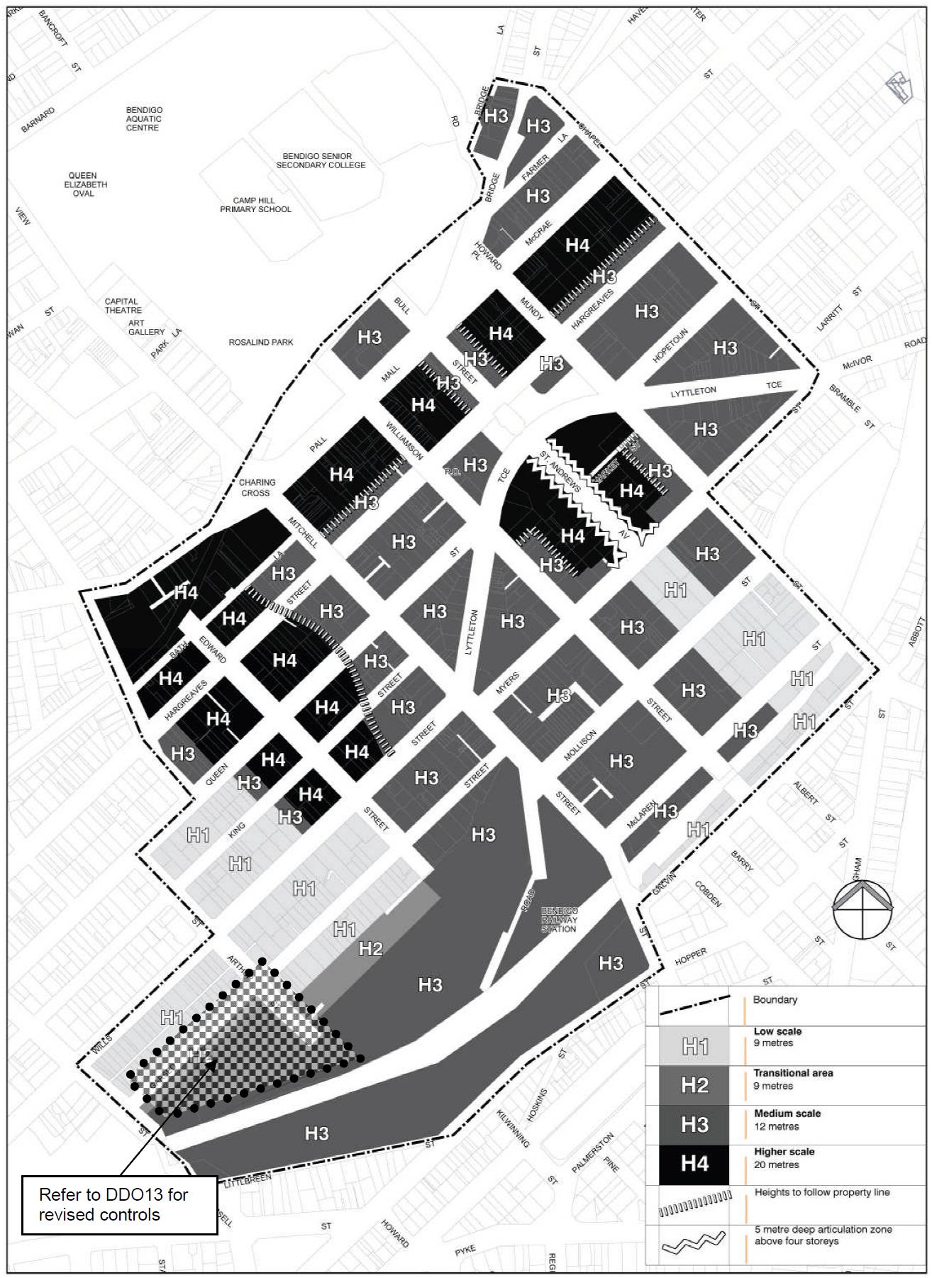
■ Area
New development and/or extensions to existing buildings should comply with the preferred maximum building heights specified in Table 1 and shown on Map 1 Building Heights.
Table 1 - Building heights
Purpose H1 Low scale 9 metres
Maximum height
Development consistent with the traditional low rise character of the area.
To provide a transition to typically lower buildings on adjoining properties. H3 Medium scale 12 metres
Transitional area 9 metres
Any building above 3 storeys should set back upper levels to avoid overshadowing of public streets, laneways, parks or other open spaces at winter solstice.
To avoid overshadowing of properties and public H4 Higher scale 20 metres
GREATER BENDIGO PLANNING SCHEME
H2
Page 1 of 5
Area Maximum height Purpose
spaces beyond what would result from a 12 metre high building, the upper levels of a building must be set back.
Note: Building heights are to be measured from the central point at the adjoining footpath level.
■
A permit may be granted to vary the preferred maximum building height where it can be demonstrated that the variation:
■
Meets the design objectives of this schedule;
■
C245gben
■
■ Achieves the visions and objectives of the Bendigo CBD Plan 2005 .
Protects heritage places on the site or in proximity to the site; and
Building frontages and set backs
New development and/or extensions to existing buildings must provide active street frontages on ground level.
■ Development must comply with the set backs specified below and shown on Map 2 (Building frontages, set backs and weather protection).
S1: Buildings with no front or side setback
■
At ground level:
■
Set buildings to front boundary with no side set back unless a set back is required to protect the heritage place on the site or adjoining site.
■
■
■
Avoid alcoves and recesses that may collect litter or be unsafe.
■ Avoid side set backs unless a pedestrian or service laneway is required.
At first floor level and above:
Provide articulation and modelling of the facade which demonstrates a sympathetic and considered response to the scale, form and detailing of other buildings in the precinct, but particularly those adjoining and in immediate visual connection to the subject site.
S2: Buildings within grounds
■
Provide front and side landscaped set backs consistent with adjoining buildings unless no set back or a non-landscaped set back is required to protect the heritage place on the site or adjoining the site.
Weather protection
■
New development and/or extensions to existing buildings must be designed to provide weather protection, such as verandahs or canopies within the area shown on Map 2 (Building frontages, set backs and weather protection).
Subdivision
The following subdivision requirements apply to an application to subdivide land: Protect existing laneways and arcades in any subdivision application.
■
GREATER BENDIGO PLANNING SCHEME
3.0 18/12/2020
Page 2 of 5
■
4.0
18/12/2020 C245gben
5.0
18/12/2020 C245gben
Encourage the creation of new laneways and arcades in accordance with Map 7 of the Bendigo CBD Plan 2005 in any subdivision application.
Signs
None specified.
Application requirements Buildings and works
The following application requirements apply to an application for a permit under Clause 43.02 to exceed the preferred maximum building height, in addition to those specified elsewhere in the scheme and must accompany an application, as appropriate, to the satisfaction of the responsible authority:
■
6.0
18/12/2020
C245gben
A site analysis plan and a written urban context report documenting how the development will achieve the design objectives of this schedule.
Decision guidelines
The following decision guidelines apply to an application for a permit under Clause 43.02, in addition to those specified in Clause 43.02 and elsewhere in the scheme which must be considered, as appropriate, by the responsible authority:
■
Whether the proposal achieves excellence in architecture and urban design.
■
■
Whether the proposal implements sustainable development principles.
Whether the proposal enhances public and private amenity.
■
Whether the proposal protects the development potential of nearby sites.
Background document
Planisphere, Bendigo CBD Plan: New Visions, New Opportunities, 2005 Map 1 to Schedule 5 to Clause 43.02
Building Heights
GREATER BENDIGO PLANNING SCHEME
Page 3 of 5
GREATER BENDIGO PLANNING SCHEME
Clause 43.02 Building frontages, set backs and weather protection Page 4 of 5
Map 2 to Schedule 5 to
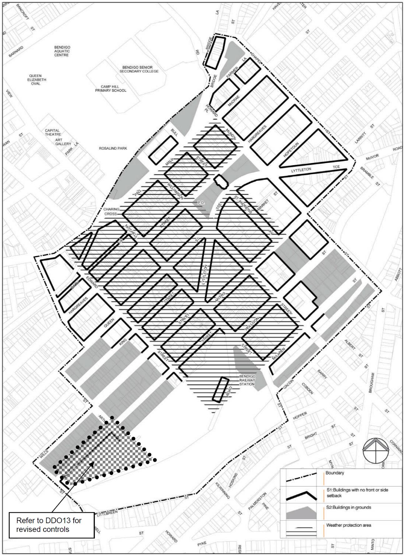
GREATER BENDIGO PLANNING SCHEME Page 5 of 5
44.04
06/09/2021
VC171
LAND SUBJECT TO INUNDATION OVERLAY
Shown on the planning scheme map as LSIO with a number (if shown).
Purpose
To implement the Municipal Planning Strategy and the Planning Policy Framework.
To identify flood prone land in a riverine or coastal area affected by the 1 in 100 (1 per cent Annual Exceedance Probability) year flood or any other area determined by the floodplain management authority.
To ensure that development maintains the free passage and temporary storage of floodwaters, minimises flood damage, responds to the flood hazard and local drainage conditions and will not cause any significant rise in flood level or flow velocity.
To minimise the potential flood risk to life, health and safety associated with development.
To reflect a declaration under Division 4 of Part 10 of the Water Act, 1989
To protect water quality and waterways as natural resources by managing urban stormwater, protecting water supply catchment areas, and managing saline discharges to minimise the risks to the environmental quality of water and groundwater.
To ensure that development maintains or improves river, marine, coastal and wetland health, waterway protection and floodplain health.
44.04-1
24/01/2020
VC160
Land subject to inundation objectives and statement of risk
A schedule to this overlay may contain:
■ A statement of risk.
■
44.04-2
17/02/2022
VC200
Land subject to inundation management objectives to be achieved.
Buildings and works
A permit is required to construct a building or to construct or carry out works, including:
A fence.
■
■
■
Roadworks, if the water flow path is redirected or obstructed.
■ Public toilets.
Bicycle pathways and trails.
■
■
■ Rainwater tank with a capacity of not more than 10,000 litres.
■
A domestic swimming pool or spa and associated mechanical and safety equipment if associated with one dwelling on a lot.
A pergola or verandah, including an open-sided pergola or verandah to a dwelling with a finished floor level not more than 800mm above ground level and a maximum building height of 3 metres above ground level.
A deck, including a deck to a dwelling with a finished floor level not more than 800mm above ground level.
■
■
A disabled access ramp.
A dependent person’s unit.
This does not apply:
■
If a schedule to this overlay specifically states that a permit is not required.
GREATER BENDIGO PLANNING SCHEME
Page 1 of 3
■
■
To roadworks or bicycle paths and trails constructed or carried out by or on behalf of the Head, Transport for Victoria, to the satisfaction of the relevant floodplain management authority.
■
To flood mitigation works carried out by the responsible authority or floodplain management authority.
To the following works in accordance with plans prepared to the satisfaction of the responsible authority:
■
The laying of underground sewerage, water and gas mains, oil pipelines, underground telephone lines and underground power lines provided they do not alter the topography of the land.
■
44.04-3
31/07/2018 VC148
44.04-4 31/07/2018 VC148
44.04-5 31/07/2018 VC148
■
The erection of telephone or power lines provided they do not involve the construction of towers or poles.
To post and wire and post and rail fencing.
Subdivision
A permit is required to subdivide land.
Application requirements
An application must be accompanied by any information specified in a schedule to this overlay.
Local floodplain development plan
If a local floodplain development plan has been developed for the area and has been incorporated into this scheme, an application must be consistent with the plan.
44.04-6 31/07/2018
VC148
44.04-7 31/07/2018 VC148
Exemption from notice and review
An application under this overlay is exempt from the notice requirements of section 52(1)(a), (b) and (d), the decision requirements of section 64(1), (2) and (3) and the review rights of section 82(1) of the Act.
Referral of applications
An application must be referred to the relevant floodplain management authority under Section 55 of the Act unless in the opinion of the responsible authority, the proposal satisfies requirements or conditions previously agreed in writing between the responsible authority and the floodplain management authority.
44.04-8
06/09/2021
VC171
Decision guidelines
Before deciding on an application, in addition to the decision guidelines in Clause 65, the responsible authority must consider, as appropriate:
■
The Municipal Planning Strategy and the Planning Policy Framework.
■
■
■
Any local floodplain development plan.
■ Any comments from the relevant floodplain management authority.
The existing use and development of the land.
■ Alternative design or flood proofing responses.
Whether the proposed use or development could be located on flood-free land or land with a lesser flood hazard outside this overlay.
GREATER BENDIGO PLANNING SCHEME
Page 2 of 3
■
■
■
The susceptibility of the development to flooding and flood damage.
The potential flood risk to life, health and safety associated with the development. Flood risk factors to consider include:
■
The frequency, duration, extent, depth and velocity of flooding of the site and accessway.
■ Tidal patterns.
The flood warning time available.
■ Coastal inundation and erosion.
■
■
The danger to the occupants of the development, other floodplain residents and emergency personnel if the site or accessway is flooded.
The effect of the development on redirecting or obstructing floodwater, stormwater or drainage water and the effect of the development on reducing flood storage and increasing flood levels and flow velocities.
■
■
The effect of the development on river, marine and coastal health values including wetlands, natural habitat, stream stability, erosion, environmental flows, water quality, estuaries and sites of scientific significance.
Any other matters specified in a schedule to this overlay.
GREATER BENDIGO PLANNING SCHEME
Page 3 of 3
18/12/2020
C245gben
1.0
18/12/2020
C245gben
2.0
18/12/2020
C245gben
3.0
10/09/2021
C243gben
SCHEDULE
1
TO CLAUSE 44.04 LAND SUBJECT TO INUNDATION OVERLAY
Shown on the planning scheme map as LSIO1
FLOODING FROM WATERWAYS (DEPTHS UP TO AND INCLUDING 350 MILLIMETRES)
Land subject to inundation objectives to be achieved None specified.
Statement of risk
None specified.
Permit requirement
A permit is not required to construct a building or construct or carry out works as follows:
■
If land has been developed in accordance with a permit, restriction or section 173 agreement requiring its ground level to be finished at least 300 millimetres above the 1 percent Annual Exceedance Probability flood level provided that:
■
Survey plans, to Australian Height Datum, confirm that the ground level has been constructed in accordance with the requirements of a permit, restriction or subdivision; and
■
Any buildings and works do not lower the ground level or result in a finished floor level for a dwelling that is below 300 millimetres above the 1 per cent AEP flood level.
Extensions and alterations to existing buildings
■
An extension to an existing building (not including an outbuilding associated with a dwelling), provided the floor level of the proposed extension is not less than the existing floor level and the gross floor area of the extension does not exceed 40 square metres.
■
■
An upper storey extension to an existing building if there is no increase in the ground floor footprint.
An extension to an outbuilding associated with a dwelling where the floor level is at least 150 millimetres above the 1 per cent Annual Exceedance Probability flood level.
New and replacement buildings
■
A replacement dwelling if it is constructed to at least 300 millimetres above the 1 per cent Annual Exceedance Probability flood level and the additional floor area does not exceed 20 square metres.
■
■
A non-habitable building (including an outbuilding associated with a dwelling) with a floor area of less than 20 square metres and which is the only non-habitable building on the lot.
An outbuilding associated with a dwelling where the floor level is at least 150 millimetres above the 1 per cent Annual Exceedance Probability flood level.
■
■
An agricultural or farm building with permanent openings, such as a hay shed, cattleyard, covered horse stable or other yards.
An agricultural building (other than one used for industrial, retail or office purposes) for the storage of farm machinery, storage of farm vehicles or a workshop associated with a rural use in a rural zone with a floor area of not more than 200 square metres.
■
A relocatable building associated with a caravan park where the floor level is at least 300 millimetres above the 1 per cent Annual Exceedance Probability flood level.
GREATER BENDIGO PLANNING SCHEME
Page 1 of 2
Other buildings and works
■
An open style fence if constructed in accordance with the definition of open style fence in the Bendigo Local Floodplain Development Plan , February 2018 and the Heathcote Local Floodplain Development Plan , May 2021.
■
■
A replacement fence in the same location and of the same type and materials as the existing fence.
A rainwater tank with a capacity of not more than 10,000 litres.
■
■ A carport.
■
A deck, pergola, or verandah, including an open-sided pergola or verandah to a dwelling with a finished floor level of not more than 800 millimetres above ground level and a maximum building height of three metres above ground level.
An inground domestic swimming pool or spa and associated mechanical and safety equipment if associated with one dwelling on a lot, and associated open style security fencing, where the perimeter edging of the pool or spa is constructed at ground level and excavated material is moved outside the 1 per cent Annual Exceedance Probability flood extent.
■
■
■
■ 4.0
10/09/2021
C243gben
5.0
10/09/2021
C243gben
■ Informal outdoor recreation, racecourse or leisure and recreation (with no permanent grandstand or raised viewing area).
A curtain style fence for a tennis court if constructed in accordance with the requirements of the Bendigo Local Floodplain Development Plan, February 2018 and the Heathcote Local Floodplain Development Plan, May 2021.
■ Public toilets
Landscaping, driveways, and vehicle cross overs associated with a dwelling, if there is less than a 50 millimetre change to existing ground levels, or if the relevant floodplain management authority has agreed in writing that the flow path is not obstructed.
Roadworks, footpaths or bicycle pathways and trails carried out by a public authority if there is less than a 50 millimetre change to existing ground levels, or if the relevant floodplain management authority has agreed in writing that the flow path is not obstructed.
Earthworks associated with the construction of a dam, where no fill is imported to the site, the dam is not constructed on a waterway, the dam does not exceed 3 megalitres in capacity and there is no embankment.
Application requirements
The following application requirements apply to an application for a permit under Clause 44.04, in addition to those specified in Clause 44.04 and elsewhere in the scheme and must accompany an application, as appropriate, to the satisfaction of the responsible authority:
■
Evidence of the existing building envelope or footprint of a dwelling that is to be replaced.
Decision guidelines
The following decision guidelines apply to an application for a permit under Clause 44.04, in addition to those specified in Clause 44.04 and elsewhere in the scheme which must be considered, as appropriate, by the responsible authority:
■
Whether the application is consistent with the performance criteria of either of the following:
■
Bendigo Local Floodplain Development Plan , February 2018
■
Heathcote Local Floodplain Development Plan , May 2021
GREATER BENDIGO PLANNING SCHEME
Page 2 of 2
45.09 31/07/2018
VC148
PARKING OVERLAY
Shown on the planning scheme map as PO with a number.
Purpose
To implement the Municipal Planning Strategy and the Planning Policy Framework.
To facilitate an appropriate provision of car parking spaces in an area.
To identify areas and uses where local car parking rates apply.
To identify areas where financial contributions are to be made for the provision of shared car parking.
45.09-1
19/04/2013
VC95
Operation
This overlay operates in conjunction with Clause 52.06.
A schedule to this overlay may:
■
45.09-2
19/04/2013
VC95
45.09-3 25/05/2017
VC133
45.09-4
19/04/2013
VC95
■ Specify additional requirements to the requirements of Clause 52.06 as allowed by this overlay.
Vary the requirements of Clause 52.06 as allowed by this overlay.
■ Specify requirements for the provision of a financial contribution as a way of meeting the car parking requirements of Clause 52.06 or this overlay.
Parking objectives
A schedule to this overlay must specify the parking objectives to be achieved for the area affected by the schedule.
Permit requirement
A schedule to this overlay may specify that:
■
The exemption from the requirement for a permit in Clause 52.06-3 does not apply. If the exemption does not apply, a permit is required for any of the matters set out in Clause 52.06-3.
■
■
A permit must not be granted to reduce (including reduce to zero) the number of car parking spaces required under Clause 52.06-5 or this overlay.
A permit must not be granted to provide some or all of the car parking spaces required under Clause 52.06-5 or this overlay on another site.
■
■
A permit must not be granted to provide more than the maximum parking provision specified in a schedule to this overlay.
A permit is not required under Clause 52.06-3.
Number of car parking spaces required
A schedule to this overlay may:
■
■
Vary the car parking rate and measure for any use listed in Table 1 of Clause 52.06-5.
■ Specify the car parking requirements for any use of land not listed in Table 1 of Clause 52.06-5.
■ Specify maximum and minimum car parking requirements for any use of land.
For any use listed in Table 1 of Clause 52.06-5, apply Column B in the Table to that use.
45.09-5 Application requirements and decision guidelines for permit
GREATER BENDIGO PLANNING SCHEME
Page 1 of 2
25/05/2017
VC133
applications
Before deciding on an application under Clause 52.06-3, in addition to the relevant decision guidelines in Clause 52.06-7, the responsible authority must consider, as appropriate:
■
45.09-6
19/04/2013
VC95
■
The parking objectives of the relevant schedule to this overlay.
Any application requirements and decision guidelines specified in a schedule to this overlay.
Financial contribution requirement
A schedule to this overlay may allow a responsible authority to collect a financial contribution in accordance with the schedule as a way of meeting the car parking requirements that apply under this overlay or Clause 52.06.
A schedule must specify:
■
The area to which the provisions allowing the collection of financial contributions applies.
■
■ When any contribution must be paid.
■
The amount of the contribution that may be collected in lieu of each car parking space that is not provided, including any indexation of that amount.
The purposes for which the responsible authority must use the funds collected under the schedule. Such purposes must be consistent with the objectives in section 4 of the Act.
45.09-7 25/05/2017 VC133
Requirements for a car parking plan
A schedule to this overlay may specify additional matters that must be shown on plans prepared under Clause 52.06-8.
45.09-8 25/05/2017 VC133
Design standards for car parking
A schedule to this overlay may specify:
■
Additional design standards.
■
Other requirements for the design and management of car parking.
Plans prepared in accordance with Clause 52.06-8 must meet any design standards and requirements specified in a schedule to this overlay.
45.09-9 25/05/2017
VC133
Decision guidelines for car parking plans
Before deciding whether a plan prepared under Clause 52.06-8 is satisfactory, in addition to the decision guidelines in Clause 52.06-10, the responsible authority must consider, as appropriate, any other matter specified in a schedule to this overlay.
GREATER BENDIGO PLANNING SCHEME
Page 2 of 2
