Road Map for Improving the Availability, Access and Use of Disaster Risk Information for Early Warning and Early Action including in the Context of Transboundary Risk Management AUC
monitoring phase especially in a system that needs to work smoothly across multiple levels, from the continental to the regional, and the national to the local levels. •
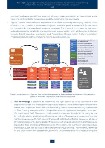
Figure 3 details the workflow of implementation of the system by identifying the four pillars of action that contribute to the overall system and that provide essential information to be consulted by the coordination operation room. The thematic components that need to be developed in parallel to one another and in connection with all the other initiatives include Risk Knowledge, Monitoring and Forecasting; Dissemination & Communication, Preparedness & Response, including raising public awareness.
AUC DREA RECS DRR DRMA
AUC DREA ACMAD RECS CC NHMS
AUC DREA ACMAD DRMA NHMS
AUC DREA DPA DSA PSD RECS DRR DRMA
AUC DREA
African Union Commission DRR Unit and Meteorology Unit
DPA
Department for Political Affairs
DSA
AUC Department for Social Affairs
PSD
Department for Peace and Security
ACMAD
African Center of Meteorological Applications for Development
RECS DRR
Regional Economic Communities Disaster Risk Reduction Unit
RECS CC
Regional Economic Communities Climate Centres
NDRMA
National Disaster Risk Management Agencies
NHMS
National Hydro Meteorological Services
UN System, International Organizations and Governments
Figure 3. Implementation Concept for the Establishment of the Supranational Multi-Hazard Early Warning System in Africa for Early Action and Transboundary Risk
1.
Risk knowledge is essential to determine the right scenarios to be addressed in the preparation phase and to assess the capacity to respond to the different possible scenario realizations. Important investments have already been made in developing national risk profiles. Country level probabilistic risk profiles are a strong asset when applied in support of a continental EWS. They need continuous improvement in order to be ready for use for multiple related applications. Quantitative risk profiles provide a measure of the risk, highlighting areas with high concentrations of potentially affected people, or at risk of physical and economic damages to infrastructures. Fully probabilistic risk profiles analyse all possible flood and drought loss scenarios. These scenarios, eventually used to produce the risk curve, can also be used as a basis for emergency planning. The scenarios, identified for the probabilistic risk assessment, provide a unique reference for understanding the
45


