Abdullah Al Kazaz
Architectural Association 4th Year Elective, Term 1
Tutors: Dr. Michael Weinstock, Dr. Elif Erdine, Dr. Milad Showkatbakhsh
Course Title: Design Science & Ecological Systems 2022

Abdullah Al Kazaz
Architectural Association 4th Year Elective, Term 1
Tutors: Dr. Michael Weinstock, Dr. Elif Erdine, Dr. Milad Showkatbakhsh
Course Title: Design Science & Ecological Systems 2022
Abstract. The research presented in this paper concentrates on the issue of Sand & Dust Storms (SDS) Baghdad, Iraq. The country experiences draughts, desertification, lack of water access, lack of electricity & energy and many more, however, SDS is the most dangerous one in Baghdad, out of all cities, but the country in its entirety as well. The aim of the project at large is to propose an innovative strategy, independent of any Iraq’s domestical issues, that entails the proposition of shield-likestructures spread across the scale of the city where it is most needed, considering important research, variables to measure, and outlining a scientifically and architecturally logical framework that follows a series of sequential steps presented in a workable and replicable manner that is feasible and can be developed in the future to eliminate mortalities due to natural causes and many more
Introduction
Iraq is one of the Middle East's most afflicted countries when it comes to SDS. The frequency of incidence has increased dramatically in the last decade and continues to rise, impacting more and more humans, crops, and quality of living, hence, the need for this study. Summers in Iraq are hot, dry, and dusty. They are caused by the "Shimali" (Arabic for northern) wind 1, which can blow over the Tigris and Euphrates River valleys of central and southern Iraq at any time of year SDS were discovered to be frequently associated with high wind speeds (15-20 ms-1) 2 and were also found to be more prevalent between March and September, particularly during the day (06:00-15:00), and to be short lived (6 hours), with the largest frequency occurring between (0-3 hours). Northern winds can persist for several days, intensifying during the day and diminishing at night, causing deadly SDS
SDS can happen both regionally and locally, where regional occurrences disperse beyond Iraq in various directions, but mainly covers a portion of Syria, crossing Iraqi land towards Kuwait and Saudi Arabia, and sometimes Iran. A primary cause of SDS in the region is climatic change, specifically a severe decrease in the yearly rate of rain fall, as well as environmental changes such as desertification, marsh drying, land degradation.
SDS are mostly created in desert areas by thunderstorm discharges or significant pressure gradients, which induce an increase in wind velocity across a wide area. The vertical extension of the elevated dust or sand is limited mostly by the stability of the atmosphere near the ground as well as the weight of the particles. A low-lying temperature inversion may constrain dust and sand to a relatively shallow layer in some instances. In other cases, dust can be raised up to approximately 6000m.
From 1980 to 2015, Baghdad saw a yearly average of 7.9 days of significant dust storms 3, compared to approximately ten such events since January 2022, each lasting at least two to four days 4 One specific SDS resulted in the hospitalization of 4,000 Iraqis in May 2022, and over 10,000 people in the first half of 2022 5, with at least 5 deaths reported as a result of the SDS that swept through Iraq. As a result of these terrible circumstances, the Iraqi government closed down for many ministerial and provincial employees that year. The SDS even temporarily halted all flights into Iraq's impacted areas, including the capital, Baghdad. In 2019, an extensive study on the economical impact of SDS in Iraq was produced by The World Bank 6 which indicated the economic cost of premature deaths caused by sand and dust inhalation climbed by 123 percent to $141 billion between 1990 and 2013. According to the report, dust in the air caused 10,400 premature deaths in Iraq in 2013, costing the economy over $15 billion, or 3% of the year's GDP. According to a 2019 World Bank research, direct costs from grounded aircraft, lost crops, and output interrupted by government-ordered holidays are estimated to be $13 billion, increasing the MENA region's total economic impact from dust and sandstorms to more than $154 billion per year.
Despite the economic impact explained above, Iraq is one of the middle eastern countries that is already severely suffering from economic instability, availability of clean water (and water generically), availability of electricity and energy. In addition, Iraq is lacking basic night-light coverage (streetlights) where only very recently contracts are starting to be awarded to gradually cover cities with solar-
1 “Shamal | Wind Current.” n.d. Encyclopedia Britannica. https://www.britannica.com/science/shamal
2 Zeyad Ahmed, “Analysis of the Climatology and Transport Pathways of Iraq Dust Storms between 19852014” https://pure.manchester.ac.uk/ws/portalfiles/portal/122873457/FULL_TEXT.PDF
3 Ali A. Attiya and Brian G. Jones, “Climatology of Iraqi dust events during 1980-2015”. https://doi. org/10.1007/s42452-020-2669-4
4 “Weather forecast counts the dust storms recorded since January until today,” Nas News https://www.nasnews.com//view.php?cat=86534
5 “Iraq’s sandstorms are threatening life in the Fertile Crescent”, Atlantic Council https://www.atlanticcouncil.org/blogs/menasource/iraqs-sandstorms-are-threatening-life-in-the-fertile-crescentits-time-the-iraqi-government-takes-a-stance/
6 “(MENA) Region: Sources, Costs, and Solution”, The World Bank https://www.worldbank.org/en/region/mena/publication/sand-and-dust-storms-in-the-middle-east-and-northafrica-mena-region-sources-costs-and-solutions
powered streetlights, the most recent contract being awarded for Al Anbar province 7 (immediately west of Baghdad)
In an ideal situation, a set of trees will significantly reduce exposure of SDS to humans and crops due to their vast surface area (Fig. 1). Since access to water is difficult in Iraq and requires a large amount of energy, planting trees on a scale of a city and larger is not convenient and efficient. In light of the slow replacements of streetlights in the country, my research proposal will focus on the design and positioning of “artificial trees” in Baghdad, the city that is most susceptible to SDS with high population, where it will protect human beings from it. The urban context needs to be studied (including human traffic, vehicular traffic, buildings), as well wind velocities. The strategy behind the proposal will automatically offer a model of an unseen design concept in the streetlight industry, providing an opportunity to erect a new network of streetlights (this will be introduced very briefly) The innovation will set an example of how science, architecture, and engineering can be bridged to tackle 2 problems with 1 solution, as this is very much needed in a country like Iraq
What can be done to shield the people of Baghdad from SDS? What is the process in achieving a positive outcome? What is the viability of such proposal? Which areas of Baghdad are most vulnerable to SDS? These are all questions that are to be considered throughout the proposal.
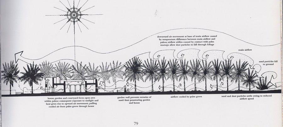
(Fig. 1) General section of a typical traditional Arabian house showing air movement in relationship with the presence of trees https://dragonsrabbitsandroosters.com/2012/02/12/lessons-from-the-najd-how-to-live-in-a-sandstorm/
The overall strategy is sequential in order of what content needs to be studied first, second, third and so on. Each content of the sequence will contribute to every step of the design experiment to maximize the likelihood of a realistic and accurate outcome A positive outcome, when visually represented, should show a similar relationship between air movement and trees as seen in (Fig. 1), excluding the shorter trees (right hand side of Fig. 1). A crucial thought to consistently maintain throughout experimentation is that SDS does not occur daily, therefore, provided that coolness maybe obstructed during hotter days, the design and layout of ATs needs to permit temporary deployment, prior to incoming SDS and after it clears. Another thought to maintain is switching to its secondary function as streetlights when not deployed. Nevertheless, during a SDS scenario, the secondary function is to be activated to enhance illumination. When designing and computing, these parameters and all remaining findings from studies
7 John Lee, “Contract Awarded for Solar Street Lights in Anbar” https://www.iraqbusinessnews.com/2022/08/22/contract-awarded-for-solar-street-lights-in-anbar/
should be inputted individually, contributing to a parametric framework which can be done in Rhino Grasshopper to ensure easiness and efficiency when testing the experiment multiple times Autodesk CFD (or equivalent) will be needed to simulate different wind scenarios to attest to the integrity of the design should Grasshopper not offer CFD plugins. In addition, QGIS is recommended to map specific variables for context analysis, if needed.
First and foremost, it is imperative to study the wind movement and velocities (unit: ms-1) in Baghdad at different heights (10m, 50m, 100m, 150m, and 200m are sufficient) to understand the magnitude of change of speed between one level to the next, starting from the top (200m) as this will heavily influence every step taken moving forward. This can be achieved through Global Wind Atlas 8 . My proposal involves identifying areas within Baghdad that greatly suffers from SDS. As a result, a full context analysis of the city must be carried out The factors to consider are but not limited to; human traffic/ density and vehicular traffic/ density (can be studied from the traffic layer in google maps. Vehicular and human traffic in most cases is directly proportional, therefore higher vehicular saturation = higher pedestrian saturation). In addition, areas with vast openness and areas with relatively low building heights. These are variables that could be mapped in QGIS to have a full overview when concluding findings. Valid areas would be of high human & vehicular saturation combined with areas consisting of a large open space and low buildings. When potential areas have been identified, a study of a more specific level needs to be done. 3D models need to be produced in Rhino as it is compulsory to carry out a wind study of the areas in question at a micro level, understanding wind movement and magnitude, in between buildings and roads, for example. Identifying strategic segments of the areas in question is needed to determine where ATs can be validly placed and have maximum effect. At this stage, roughly pinpointing their locations in the 3D models is valuable. Using the results from the micro wind analysis, the series of ATs need to be wisely extrapolated to cover the entirety of the areas and pinpointing their locations.
Having completed wind analysis on multiple scales, the design, dimensions, and orientation of the ATs should be completely determined by them. Understanding the characteristics of trees is recommended as it could prove useful when this knowledge is considered when designing The main objective of the design is to maximize the effect of the primary function while minimizing the dimensions as much as possible to save material and costs. Achieving this is done by orientating the ATs correctly with respect to wind movement at their immediate locations (this could vary as ATs are not in 1 location). This could also be done by using the structure of leaves to our advantage and make use of its potential while bearing in mind that they must be deployable when needed and retracted when not needed- the leaves are the most important part of the ATs. Iterative design developments are to be expected as constant tests need to be made with Autodesk CFD (or equivalent) to understand the viability of each iteration and determine which design elements are successful and how they might be improved. Note that the height of the overall design should be dependent on the height of the surrounding buildings. The ATs need to be of similar heights with surrounding buildings. This also is another variable that needs to be tested out continuously throughout the experiment. It is possible to end up with a variety of differently sized ATs within the same segment of the area as it could be more materially and spatially efficient, and more effective.
The motivation of this research was to tackle an extremely severe problem that not only Baghdad is facing, but the whole country. The powerful winds are no joke in such a country where draughts and desertification are constantly increasing, affecting humans, crops and others, hence the insistence and the need of this study that is revolved around the generation and presentation of a workable framework that is simple, logical, and does not interfere with the politics of the country. It is vital to understand and realize that having such framework that is independent of any day-to-day problems in the country
8 “Baghdad, Iraq”, Global Wind Atlas. https://globalwindatlas.info/en/area/Iraq/Baghdad
reduces the complexity and increases the validity and feasibility of future developments and implementations, and in a country like Iraq, this accurately is what the country needs.
The framework explained in this paper follows a traditional scientific and architectural approach where a macro context analysis is firstly required before diving to multiple levels of micro analysis, leading to the design phase where studies of the important factors heavily influences the design in favour of maximizing the effect of the proposal, and most importantly the iterative process that is automatically bundled with the framework as a method of assessing and learning from iterations which entails wiser improvements to ensure the proposal’s integrity of the highest level.
The main restriction and obstacle that arise in any environmental-related experiments is the accuracy, integrity, and reliability factors as the method and iteration process in this paper is solely computational and not physical and does accommodate a physical testing component. Undoubtedly, constant physical testing throughout the iteration process is always essential, especially in a proposal like this as integrity can only be accurately determined when simulated in real-life scenarios. Some finer details, such as sudden wind gusts, cannot be predicted by CFD simulation software, provided it is a one-off, random event. Nevertheless, the methodology presented in this paper should prove to be convincingly accurate, and these limitations will be tackled in due course.
5- References
Attiya, Ali. A., and Brian G. Jones. 2020. “Climatology of Iraqi Dust Events during 1980–2015.” SN Applied Sciences 2 (5). https://doi.org/10.1007/s42452-020-2669-4
Dagres, Holly. 2022. “Iraq’s Sandstorms Are Threatening Life in the Fertile Crescent. It’s Time the Iraqi Government Takes a Stance.” Atlantic Council. June 23, 2022. https://www.atlanticcouncil.org/blogs/menasource/iraqs-sandstorms-are-threatening-life-inthe-fertile-crescent-its-time-the-iraqi-government-takes -a-stance/
Editor. 2022. “Contract Awarded for Solar Street Lights in Anbar | Iraq Business News.” August 22, 2022. https://www.iraq-businessnews.com/2022/08/22/contract-awarded-for-solar-streetlights-in-anbar/
“Global Wind Atlas.” n.d. Globalwindatlas.info. Accessed January 11, 2023. https://globalwindatlas.info/en/area/Iraq/Baghdad
“Lessons from the Najd – How to Live in a Sandstorm.” 2012. Tales of Dragons, Rabbits and Roosters. February 12, 2012. https://dragonsrabbitsandroosters.com/2012/02/12/lessons-fromthe-najd-how-to-live-in-a-sandstorm/
“Sand and Dust Storms in the Middle East and North Africa (MENA) Region: Sources, Costs, and Solutions.” n.d. World Bank. https://www.worldbank.org/en/region/mena/publication/sandand-dust-storms-in-the-middle-east-and-north-africa-mena-region-sources-costs-andsolutions
“Shamal | Wind Current.” n.d. Encyclopedia Britannica. https://www.britannica.com/science/shamal.
Wahab, Zeyad. n.d. “Analysis of the Climatology and Transport Pathways of Iraq Dust Storms between 1985-2013.” Accessed January 11, 2023. https://pure.manchester.ac.uk/ws/portalfiles/portal/122873457/FULL_TEXT.PDF
“Weather forecast counts the dust storms recorded since January until today” n.d. Www.nasnews.com. Accessed January 11, 2023. https://www.nasnews.com//view.php?cat=86534.