DESIGNING WITH EMPATHY:
Harnessing indicator species’ perspective for resiliency

Delphine M. Homerowski

Harnessing indicator species’ perspective for resiliency
A capstone design research project submitted in partial fulfillment of the Plan B requirements for the degree of
MASTER OF LANDSCAPE ARCHITECTURE
May 2023 by Delphine M. Homerowski
Capstone committee: Phoebe White, Chairperson
Dr. Regina Ostergaard-Klem, PhD
Keywords: empathetic design, indicator species, ecosystem services, wetlands, hydrological network, landscape ecology, sustainability, urban scape.

I would like to express my gratitude to Phoebe White and Dr. Regina Ostergaard-Klem for their wonderful guidance, support, and encouragement that helped me grow as a designer and craft a project that I am proud of. To my cohort, thank you for making my time at SoA such a wonderful experience. To Hana Fulghum, Kenneth Guillen, Markus Rodriguez, and Bryson Tabaniag, thank you for all the late nights and words of encouragements. Your friendship has been an anchor throughout this journey, and I am so grateful for all of you. To my girls, Jenna Baraki, Lindsey Dugas, Julia Finch (and Mari), Marissa Kunsch, and Gabrielle Lout, your love and support mean the world to me. Thank you for cheering me on every step of the way and reminding me what being part of community means.
Enfin, le plus important, merci à ma famille; ma maman, mon papa, ma marâtre et mon frère qui m’ont encouragée à bien des égards, depuis l’autre côté du globe. Je chéris votre soutien inconditionnel dans toutes mes entreprises et tout votre amour plus que tout.


Definition of key terms in the context of this research
100-yr flood
Describe the probability of an extreme hydrologic event (flood) as having a 100-year recurrence interval. In other words, a flood of that magnitude has a 1 percent chance of happening in any year (U.S. Geological Survey).
Ahupua‘a
‘Land division, usually extending from the uplands to the sea, so called because the boundary was marked by a heap (ahu) of stones surmounted by an image of a pig (pua’a), or because a pig or other tribute was laid on the alter as tax to the chief.’ (University of Hawai‘i).
‘all the benefits that nature provides to humans, through habitats and biodiversity, essentially making and sustaining life.’ (Food and Agriculture Organization of the United Nations) Ecosystem services
Infrastructure
Refers to the traditional stormwater infrastructure found in the built environment, which is usually composed of channelized streams, gutters, drains, pipes, etc. (US EPA)
Systems
Refers to the natural hydrological phenomena relating to the water cycle, such as precipitation and evaporation, as well as the structures that are employed to manage hydrological resources.
Resilience
‘the ability of a system to bounce back, to repair itself , to restore itself to the desired state of health or behaviour.’ (Meadows)
‘Species whose presence or status is representative of the conditions of their surrounding environment or of the state of their ecosystems.’ (Siddig et al.) Indicator species
Urbanization
Concentration of human population into specific geographic areas.
Empathetic design
Design that investigates and harnesses the perspective and needs of fauna and flora species, to create landscape designs that are supportive of the species needs and ecological functions.
The study of spatial patterns, ecological objects, and the ecological processes that exist between them (Forman & Gordon). Landscape Ecology
Wetlands
‘Wetlands are areas where water covers the soil, or is present either at or near the surface of the soil all year or for varying periods of time during the year, including during the growing season.’ (US EPA)
Empathy
Placing one-self in the position of another species to assess and understands its ecosystem needs.
Mostly refers to taro patches, but can also generally refer to irrigated terraces.

At its foundation, this research argues that cities are built with an anthropocentric lens and tend to have little oversight for natural systems. In their present form, urban centers depict little to no consideration for natural systems; cities have been designed atop essential ecosystems and habitats, leading in some cases to near-complete erasure. The loss of these natural systems resulted in the loss of biological functions and services that are critical for ecosystem health and for the resilience of both natural and human systems. The erasure of hydrological systems and wetland habitats, for instance, led to the removal of ecosystem functions that are essential in mitigating weather events, and rendered cities highly non-resilient in the face of climate change-related flooding events. Drawing from these observations, this research argues in general that to mitigate flooding and extreme weather events, a paradigm shift must happen in how cities are designed. More specifically, this project makes the case for a more empathetic design approach. In the context of this research, empathetic design is defined as a design approach that focuses on embracing the intrinsic inclination of natural systems and on making sure that the needs of these system’s protagonists are integrated within the designed landscape. Ultimately, empathetic design aims to create conditions that are conducive to ecosystem functions rather than erasing them.
A design and planning approach that focuses on empathy starts with understanding and considering other the perspectives of species that simultaneously rely on and contribute to the essential ecosystem functions of natural systems.
These species are often referred to as indicator species, and in Hawai‘i wetlands Native Hawaiian waterbirds often assume this role. This research seeks to create a design framework for more resilient cities. This framework focuses on embracing natural hydrological phenomena by re-introducing wetland habitats within the urban fabric. This framework is informed by both landscape ecology concepts as well as the perspective of Native Hawaiian waterbirds’ landscape needs. The concepts allow to create an urban-scale hydrological network that restores natural ecosystem functions that are key in mitigating urban flooding and in creating more resilient cities.

Cities are and have always been great hubs of opportunities for human populations. Over the last century, urban migration has surged. While urban areas provide access to resources, contributing to a higher quality of life for people, their existence/structures have caused significant damage to biodiversity. The sprawl of cities has taken over natural landscapes and habitats, has permanently altered ecosystem dynamics, and rendered these landscapes unsustainable. Wetland habitats are some of the landscapes that have been severely impacted by the trends of urbanization (Ramsar). The erasure of wetland ecosystems has also led to the erasure of the ecosystem services that wetlands provide, one of them being flood mitigation. The looming threat of climate change, paired with the systematic infrastructure failure that climate change causes, has pushed municipalities and private entities alike to prioritize sustainability and draft policies to combat flooding and sea-level rise. The Association of Landscape Architects (ASLA) is one of those organization. In its most recent Climate Action Plan, ASLA establishes new goals all geared towards achieving resilience and aiming to “provide significant economic benefits in the form of measurable ecosystem services, health co-benefits, sequestration, and green jobs.” However, achieving these sustainability targets has been a challenge for most cities due to a lack of understanding of urban dynamics and a fundamental flaw in the paradigm: cities are designed from an anthropocentric perspective, often negating the needs of other living organisms within their realm. Humans must reconcile with the fact that, in their present form, urban environments are largely designed in a rigid structure, going against ecosystems’ natural ability to self-organize and change over time, which hinders on their ability to perform key ecosystem functions that sustain life. To truly create resilient urban centers, a paradigm shift is necessary. Empathy must be put at the forefront of the design process to understand the complexity of ecosystems, as well as to restore their key ecosystem services. In this research, empathy is
defined as placing one-self in the position of another species to assess and understands its ecosystem needs. Empathy is used as a guide to re-envision the intrinsic value of the environment and of all of the life forms that inhabit it. The understanding of natural system serves as the foundation for a more holistic approach to urban planning and design. Ultimately, understanding not only the elements that compose a system, but also the dynamics that exist among those elements is critical to creating resilient systems (Reed and Lister 30).
Based on the notion that empathy must be central to the design process to create resilient systems, this research positions itself at the intersection of ecology, planning, and design to create an actionable framework that challenges landscape architects and planners to rethink how designs of the urban space are crafted. With a focus on empathy as a guide for design, this capstone project aims to investigates the critical role of nonhuman species in sustaining key wetland landscapes, their contribution to local ecosystems, as well as the ecosystem services that they generate. Ultimately, this research aims to create landscape conditions that empathize with nature and its protagonists rather than trying to efface them.
This research draws inspiration from the uniqueness of the Hawaiian archipelago, where challenges of climate change, species extinction, limited resources, and socioeconomic imbalances intersect into a fascinating illustration of the complexity of urbanization dynamics, making it an ideal case study for implementation. By investigating the perspective of four native Hawaiian waterbirds to act as guides for design and as indicator species for the health of the wetland ecosystems, this research seeks to develop a design framework that harnesses the waterbirds’ needs to restore natural hydrological networks and wetland habitats in urban areas that are threatened by systematic and forecasted flooding, ultimately leading to a more resilient future.
Research questions
To guide this research process, this project asks three primary questions:
1. How can a selection of a subset of native Hawaiian waterbirds community act as indicator species to guide the design of urban hydrological systems that allow the species to perform their full range of ecosystem functions?
2. How can restoring natural hydrological networks and wetland habitats using principles of landscape ecology help address climate-related urban flooding?
3. How can designers’ empathy for native Hawaiian waterbirds help craft a more resilient future for urban areas?
Methodology
To create this framework and inform design, this project the project employs a multi-step approach, combining historical research, literature review, and spatial analysis to generate principles for design. First, using historical documents and photographs and Geographic Information Systems (GIS), this project contrasts assumed historic as well as existing hydrological dynamics to identify key intervention areas that are simultaneously of historical hydrological relevance and that are threatened by climate change-related flooding. Second, it investigates concepts of landscape ecology, ecosystem services, and indicator species through a review of the literature to understand the role of landscape systems and their species in crafting resilience. Finally, this research analyzes literature and conservation plans pertaining to a selected community of native Hawaiian waterbirds to build an understanding of their landscape needs to generate a design approach and to inform landscape design moves.
The lessons learned from this investigative process aim to create an urban design framework to reintegrate critical wetland habitats in the urban fabric to alleviate the impacts of climate change and associated flooding and, as a result, increase resiliency potential. The results are compiled in this book.


In the early days of the Industrial Revolution, the only 7% of the world’s population lived in urban areas (Worldbank). However, the pull of opportunities for greater access to resources, financial gains, knowledge, and innovation rapidly made cities an attractive hub for people from rural communities seeking better prospects. Urbanization trends never ceased to grow, so much so that in 2018, the United Nations reported that, for the first time in history, the majority of the world’s population lived in cities, with the number of megacities (cities with over 10 million people) swelling (United Nations, Department of Economic and Social Affairs). To accommodate this growing urban population, cities continue to sprawl outwards, engendering the creation of new urban conditions, from peri-urban to suburban areas, spawning across acres upon acres, and encroaching upon and erasing habitats and biodiverse environments, leaving little untouched by the actions of man (Bai et al. 217).
While the concentration of resources within cities creates a myriad of benefits for humans, it simultaneously puts them at risk from numerous environmental hazards, such as flooding, especially in the context of climate change. Indeed, the concentration of assets and resources into one geographical area increases the risk for higher life and economic loss in the event of an extreme weather event. (United Nations, Department of Economic and Social Affairs; McGranahan & Satterthwaite). However, the way cities have been designed also contributes to the severity of impacts from climate change. Cities have often been designed atop of natural lands, and prioritized gray infrastructure, which has not only erased numerous habitats but also limited the capacity of ecosystems to perform their natural functions (Adla et al.) Cities’ design tends to prioritize human needs and comfort over biodiversity and ecosystem. This fundamentally anthropocentric lens puts so much emphasis on comfort and practicability and tends to negate the existence of natural systems and species, resulting in
vast, densely populated, low-biodiversity areas that exacerbate extreme weather events, making cities disproportionately vulnerable to environmental hazards. Simultaneously, cities have been built atop pristine lands, and acres of natural areas, essentially erasing them and their biodiversity and resulting in the perpetual alteration of natural ecosystem dynamics that would otherwise help in mitigating these extreme weather events (Adla et al.).
Wetland habitats are a great example of this largescale erasure (Ramsar; United Nations Climate Change). Before the Industrial Revolution, wetland habitats were only minimally impacted by human activities, however, as urban growth increased, wetlands habitats started to rapidly disappear; the trends of urban growth and wetland disappearance are in an almost perfectly inverted correlation (Hu et al., United Nations Climate Change). Since the 1800s, over 87% of all the wetlands on Earth have disappeared (Ramsar, 2018). The Hawaiian archipelago is one of the many regions that has seen significant changes to their originally diverse and numerous wetland habitats and their distribution since pre-settlement development. On O‘ahu alone, 65% of wetlands are estimated to have been lost to development (van Rees and Reed). The Waikīkī neighborhood on O‘ahu, is an example of erased wetland habitats to the profit of development. In the 1920s, what is known today as the Ala Wai Canal, was dredged to transform Waikīkī into the tourism engine that it is today; the land was filled, leaving no remnants of the once rich hydrological wetland ecosystems of healthy riparian habitat, estuarine wetlands, agricultural fields, and fishponds that were once thriving at that location (Cocke, 2013).
The shortsighted approach of anthropocentric design comes at a cost, as it hinders natural systems’ ability to perform their natural functions, ultimately reducing their resilience, or ability to bounce back following a disturbance.
Lack of resilience in cities
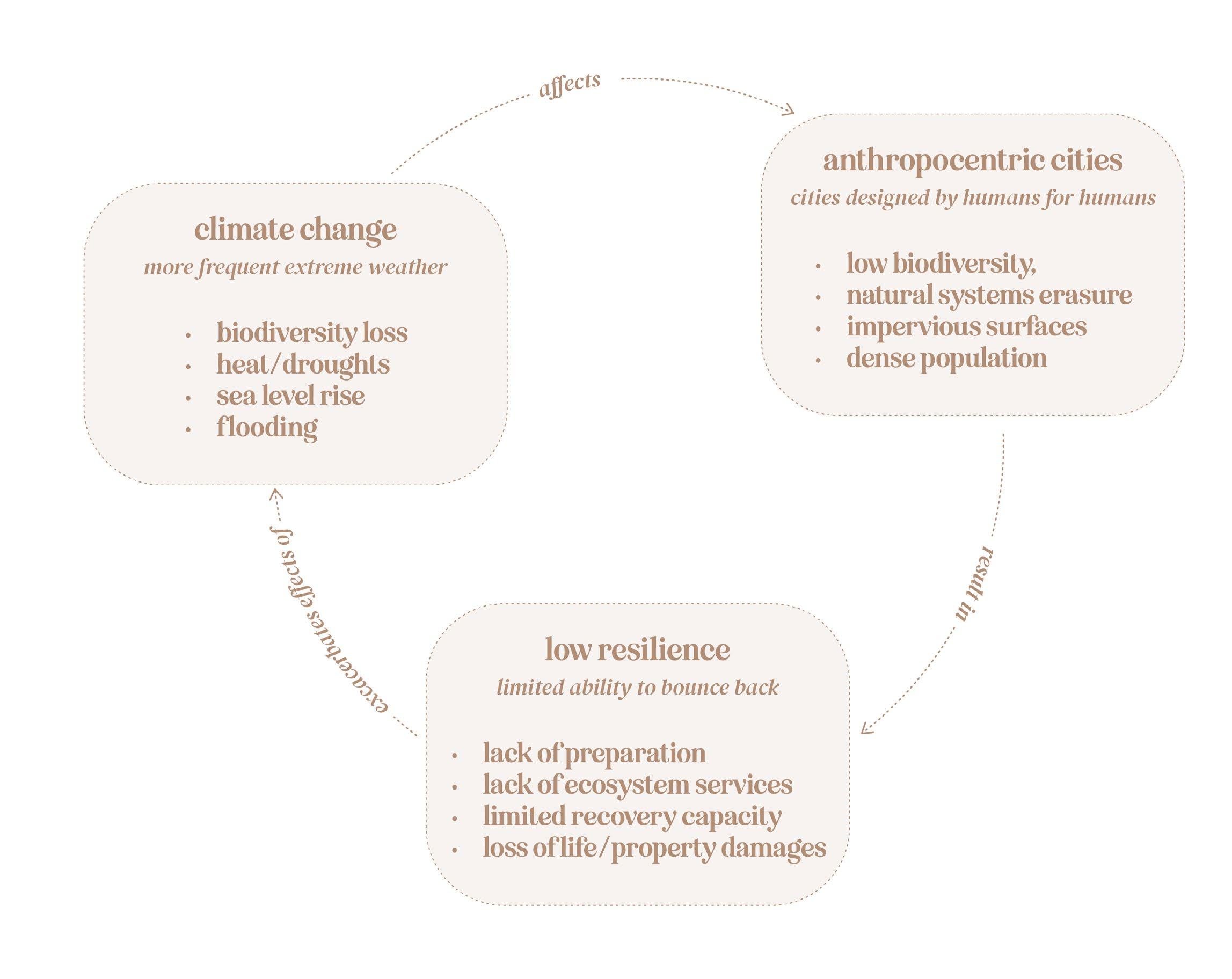
Diagram illustrating the correlation between anthropocentric design, climate change, and low resilience.


Worldwide population per city
The large population size in city reflects the trends of urbanization worldwide.


Wetlands distribution
‘Wetlands are areas where water covers the soil, or is present either at or near the surface of the soil all year or for varying periods of time during the year, including during the growing season.’ (US EPA)
Wetland cover only about 6% of the world’s surface and vary greatly in ecosystem types, but provide invaluable services to human kind (United Nations).


from State of Hawai‘i, Office of Planning.

Throughout history, human populations have always settled by water resources to access direct water supply and sustenance, irrigation for agriculture, and rivers to connect to commerce (Fang and Jawitz). However, an often-overlooked layer of benefits provided by these water resources are known as ecosystem services. Daily defines ecosystem services as “the conditions and processes through which natural ecosystems, and the species that make them up, sustain and fulfill human life” (3). In broad terms, these ecosystem services are all the benefits that nature provides to humans, through habitats and biodiversity, essentially making condition conducive for life and sustaining life.
Ecosystem services are classified under four categories: provisioning, regulating, supporting, and cultural services. Provisioning services usually refer to the goods extracted from nature such as food and water (Millennium Assessment). Regulating pertains to control or mitigation, such as flood or disease control, while supporting services are the underlying cycles that contribute to maintaining conditions for life (e.g. nutrient cycling). Lastly, cultural services are associated with all of the spiritual and recreational practices that humans derive from nature (Millennium Assessment). Wetland habitats provide numerous ecosystem services that span all four categories. From producing food to acting as buffers against storm surges and floods, and supporting filtration and groundwater recharge, wetlands play a vital role in sustaining and protecting millions of people around the world (MacGranahan & Satterthwaite; US EPA).
However, to properly provide these services, the organisms that inhabit wetlands must be able to perform the full range of their ecosystem functions. These functions refer to all of the interactions that take place among organisms as well as the ones that occur between them and the landscape (Millennium Assessment, 2005). From the above definitions of ecosystem services and ecosystem functions, it could be inferred that, to be healthy and generate ecosystem services, ecosystems must contain all of the necessary agents (i.e. fauna, flora) and foundational elements, and ensure that the interactions between these elements are not severed. (de Groot et al.; US EPA)

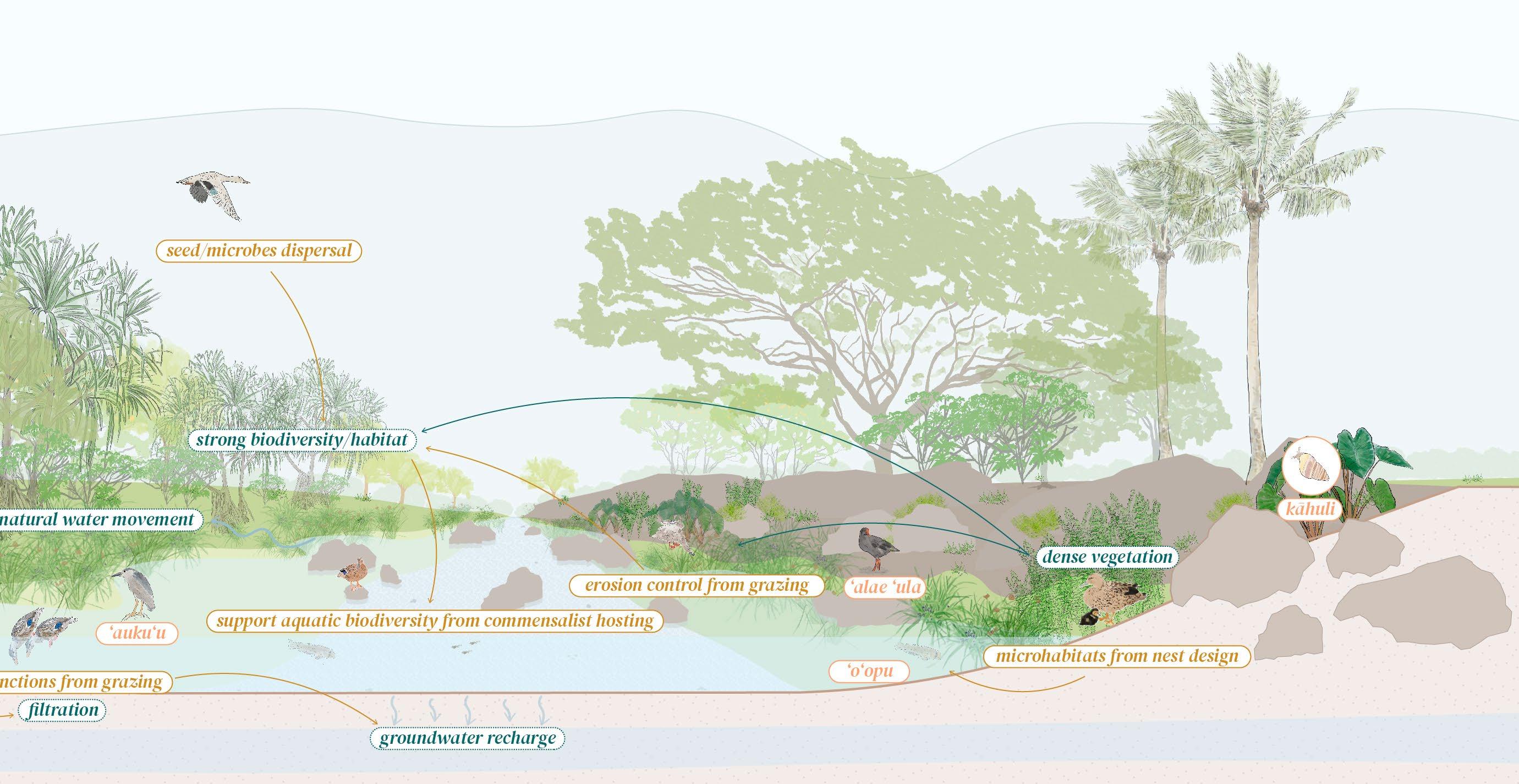
Wetland habitats provide essential ecosystem functions and services. Beyond providing habitat for wildlife, wetlands also provide effective protection against flooding. For instance, the anchoring of the shoreline allows to creation a buffer or protection from tidal and ocean movements. The topography of the wetland itself in a basin allows it to catch and hold stormwater runoff, effectively acting as a flood control barrier.


Waterbirds’ ecosystem services
Waterbirds are direct agents of these ecosystems. These feathered creatures play a direct role in supporting wetland ecosystems by dispersing animal and plant propagules, contributing significantly to biodiversity. Birds also assist in regulating these ecosystems by acting as natural pest control, and play a role in cultural practices by providing recreational and educational opportunities. Birdsong has even been shown to have a calming effect on the human nervous system, directly contributing to our well being (Whelan et al.; Green and Elmberg; Begum).
Beyond their ecosystem functions, waterbirds can also serve as indicator species for the health and productivity of wetland ecosystems. Indicator species are species whose presence and status can provide indication of the conditions of their surrounding environment (Siddig et al. 224; National Geographic).


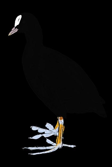
In Hawai‘i, these native waterbirds are important agents of wetland ecosystems and can be considered as indicator species or bio-indicator, for the wetland ecosystems that they inhabit. The community of native Hawaiian waterbirds selected for this research is composed of the ‘Ae‘o (Himantopus mexicanus knudseni), ‘Alae ke‘oke‘o (Fulica alai), ‘Alae ‘ula (Gallinula galeata sandvicensis), and the Koloa maoli (Anas wyvilliana). This waterbird community is of particular significance to both Hawaiian culture and the health of wetland ecosystems.

The presence of these waterbirds informs on the characteristics of the landscape, such as water height, and the presence of other species such as aquatic invertebrates, overall reflecting the ecological conditions of the wetlands (Green and Elmberg).
The presence (or lack thereof) of these species in the landscape provides valuable insights on the health status of Hawaiian wetlands, such as detecting saltwater intrusion through salinity levels, amounts of pollutants in the water, and monitoring the presence of aquatic and riparian plants. For example, all four of the waterbirds cited above are
sensitive to salt concentration in the water. The disappearance of these birds from a given wetland landscape could potentially indicate that salinity levels have increased. These observations can clue scientists and ecologists on possible changes in the ecosystem conditions, and help conservation efforts. Additionally, the waterbirds interactions with the landscape, allow them to perform vital functions that directly support the making of healthy wetlands. For instance, by grazing on wetland edges, the Koloa maoli, can help support natural grassbed functions, subsequently supporting plant growth and nutrient exchange.


In essence, these birds can be considered as guides for the creation of healthy wetlands in Hawai’i, and investigating the connections that exist between them, other species, and their environments helps building an understanding of the requirements for a healthy wetland (Green and Elmberg; U.S. Fish and Wildlife Service; State of Hawai‘i, Department of Land and Natural Resources, Division of Forestry and Wildlife).


Illustrating their primary threats, predators, and diet components. Adapted from State of Hawai‘i

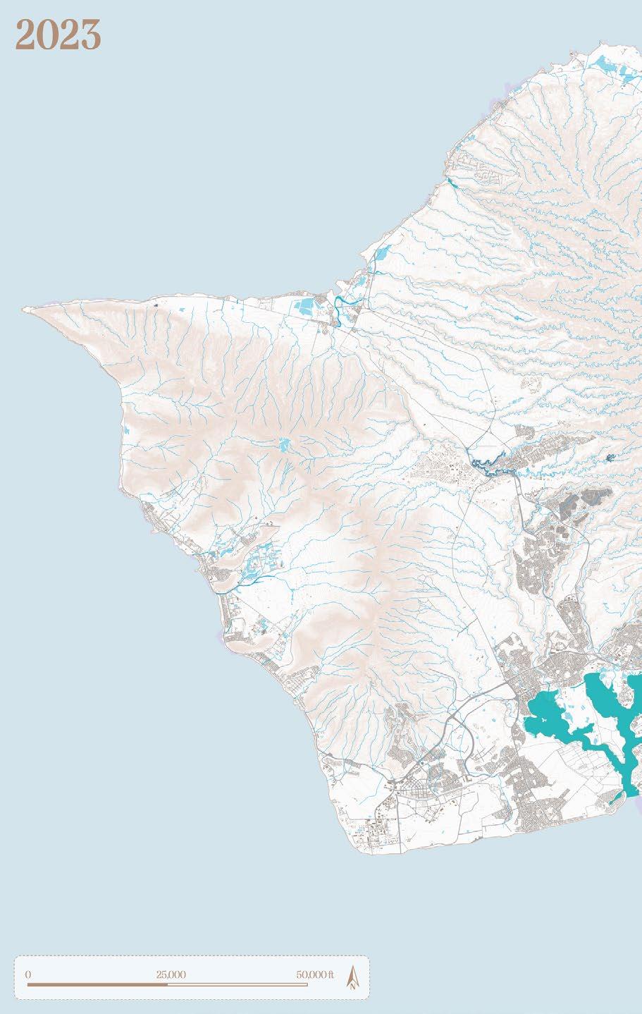
As previously established, the erasure of wetlands across the Hawaiian Islands has been commonplace. Historical accounts, maps, and photographs provide information on the original extent and conditions of these habitats. In the Primary Urban Center (PUC) of Honolulu, which extends from Pu‘uloa (Pearl Harbor) to Lē‘ahi (Diamond Head) and which has consistently been the most developed area across the archipelago, urbanization has left almost no trace of historic wetlands conditions.
The selected community of waterbirds is largely absent from the PUC because it relies on three primary wetland types, palustrine, temporary, and riverine, which either are no longer present or have been severely impaired (U.S. Fish and Wildlife Service).
In the context of climate change and the increased number and intensity of flooding events that are associated with it, impaired streams are a tremendous obstacle to localized and overall resilience (US EPA). Spatial analysis and GIS data of projected sea level rise and 100-year flood events highlights some of the areas that will be the most impacted by a changing climate within urban Honolulu (State of Hawai‘i, Office of Planning and Sustainable Development).
Foreseeably, these areas overlap with precedent locations of riverine and temporary wetlands, which not only confirms the importance of wetlands in creating resilience in urban Honolulu, but also pinpoints opportunity areas for intervention. These high-risk flooding areas must be re-designed and effectively connected to accommodate long- and short-term hydrological fluctuations. Principles of landscape ecology are a design resource that can contribute to address these hydrological challenges and help to create a new framework for hydrological resources in the cityscape.


Adapted from State of Hawai‘i, Office of Planning.

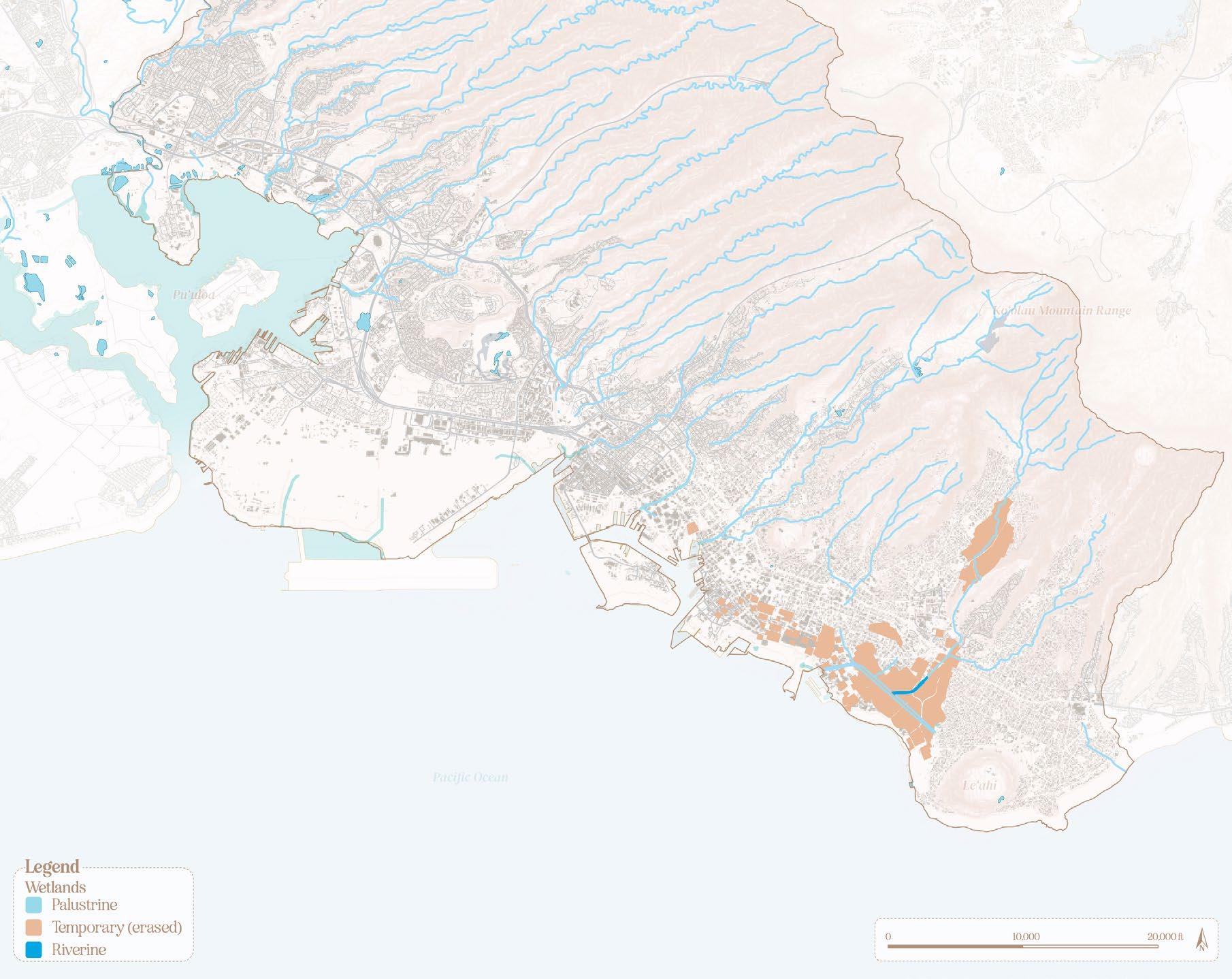
Map of the three primary wetland types, palustrine, temporary, and riverine, that the community of waterbirds relies on.
from

Palustrine wetlands are generally represented by marshes or swamps and are fed by surface water and rainfall. Although not connected to the ocean, palustrine wetlands are often located near coastal waters, benefiting from ocean spray and resulting in a small concentration of salt (Forest Service, USDA; EPA).
adapted from Forest Service, USDA, US EPA. Map adapted from State of Hawai‘i, Office of Planning.


Ideal/historic conditions:
Under ideal/historic conditions, these wetlands slowed down hydrological movement from both tidal variation and rain events acting as buffer for in-land habitats. Their biodiversity was likely rich, where the communities of waterbirds and their companion species were thriving and able to perform a full range of ecosystem functions.


Existing conditions:
Some palustrine wetlands are still found across the area, primarily around Pu‘uloa and provide a glimpse into the ideal characteristics of these wetlands, but their fenced boundaries and fragmented nature limit the waterbirds’ ability to perform their full range of ecosystem functions.


Temporary wetlands, generally referring to agricultural wetlands, have been entirely effaced from the PUC (Hawai‘i State Office of Planning; Wall). These habitats were simple topographic shallow depressions fed by fresh water from other aquatic sources or possibly by engineered traditional hydrological systems. Temporary wetlands, acted as hydrological stepping stones for biodiversity (Calhoun et al.; Lawler).
Diagram adapted from Calhoun et al.; Lawler. Map adapted from State of Hawai‘i, Office of Planning.


Ideal/historic conditions:
In Hawai‘i, temporary wetlands were primarily vegetated by kalo (Colocasia esculenta) and rice (Oryza sativa) and played an significant cultural and economic role in feeding and supporting the population of the islands (Waikīkī Streams; US EPA; Calhoun et al.; Lawler). Waterbirds were direct actors of these wetlands, actively contributing to support farming activity by serving as pest control.


Existing conditions:
Fast forward to present conditions, these wetlands have been filled and replaced by the urban edge, which does not present any of the necessary landscape characteristics for waterbirds to inhabit (State of Hawai‘i, Department of Land and Natural Resources, Division of Forestry and Wildlife).


Riverine wetlands are characterized by freshwater rivers, streams, and riparian edges (State of Hawai‘i, Department of Land and Natural Resources, Division of Forestry and Wildlife; US EPA; (The Nature Conservancy, Conservation Gateway). These habitats are usually associated with an adjacent floodplain varying in size depending on precipitation and surface flow levels.
Diagram adapted from State of Hawai‘i, DLNR. Map adapted from State of Hawai‘i, Office of Planning.


Ideal/historic conditions:
Under historic/ideal conditions, these habitats were healthy waterways, densely vegetated, where the totality of the waterbird community was present and able to perform its full range of ecological functions. Streams also assured the role of hydrological connectors, which allowed them to redistribute both biodiversity and water resources.

Existing conditions:
In 1996, the State of Hawai‘i assessed that about 19% of O‘ahu’s streams had been partially or entirely channelized through gray infrastructure (State of Hawai‘i, Office of Planning and Sustainable Development). These changes in streams’ natural conditions not only rendered them mostly inhabitable for waterbirds, but also impacted stream’s ability to alleviate and mitigate flooding impacts (Wu). In the context of climate change and the increased number and intensity of flooding events that are associated with it, impaired streams are a tremendous obstacle to localized and overall resilience (US EPA).


Spatial analysis and GIS data of projected sea level rise and 100-year flood events highlights some of the areas that will be the most impacted by a changing climate within urban Honolulu (State of Hawai‘i, Office of Planning and Sustainable Development).

Foreseeably, these areas overlap with precedent locations of riverine and temporary wetlands, which not only confirms the importance of wetlands in creating resilience in urban Honolulu, but also pinpoints opportunity areas for intervention.
Adapted from State of Hawai‘i, Office of Planning.


These high-risk flooding areas must be re-designed and effectively connected to accommodate longand short-term hydrological fluctuations. Principles of landscape ecology are a design resource that can contribute to address these hydrological challenges and help to create a new framework for hydrological resources in the cityscape.
LANDSCAPE ECOLOGY PRINCIPLES, AND EMPATHETIC FRAMEWORK
Richard T. T. Forman and Gordon (1986) describes landscape ecology as the study of spatial patterns, ecological objects, and the ecological processes that exist between them. Landscape ecology represents an alternative perspective or paradigm on how to describe and approach the landscape (Wu). In approaching resilience through landscape design, landscape ecology concepts can be particularly helpful in characterizing the components of the hydrological network and laying the foundations for an urban-scale design framework for resilience.
Theories of landscape ecology as presented by Forman describe the landscape as organized in a fundamental structure of patches, corridors, and background matrix. Patches are broadly defined as assemblages of fauna and flora species that are grouped within one spatial area. All patches are recognizable through the contrast of their boundaries against the wider landscape. Forman describes various subcategories of patches: disturbance, remnant, introduced patches, and environmental resources patches. Environmental resource patches differ from their counterparts in that they are not created by disturbance. Indeed, whereas disturbance, remnant, and introduced patches owe their existence to ephemera, disappearance of a given plant species, or to the introduction species, environmental resources are defined as stable environments that are a direct result of spatial conditions, wetland habitats are examples of these patches. Edges conditions of patches are also important in determining patches conditions. Edges are circumscribed as the outer boundary of the resource patch. Edges may simultaneously shelter patches from external natural processes, while also harboring their own ecology. The second structural element of the landscape is corridors. Corridors are strips of land that run from a set of edges and patches to another, and whose
own environmental conditions differ from the ones adjacent to them on either side. Corridors are essentially connectivity agents, moving and filtering other landscape elements. Finally, the background matrix is, broadly speaking, the larger landscape within which each of these patches and corridors operate (Forman & Gordon).
Applying these landscape ecology concepts, to the hydrological conditions of Honolulu, streams, wetlands, and floodplains can be classified as corridors, patches, and edges, respectively. This perspective not only acknowledges the place of streams, wetlands, and floodplains within the larger landscape context, but also sets the premise for a new hydrological network through which new wetland habitats are integrated and interconnected within the urban scape in the pursuit of resilience.
A hydrological network would essentially use these principles to categorize patches and edges zones for flooding mitigation and connect them through newly designed streams. In this configuration, patches would contain excess water, edges would act as buffers from flooding, and streams would redistribute runoff, all three elements working together to diffuse flooding and increase resilience. In their nature of riparian corridors, streams can serve as building blocks for this hydrological network, so consequently design interventions should start with them.

Hydrological network
Under ideal conditions, healthy streams and wetlands represent a hydrological network that not only acts as ecological habitats and redistributes biodiversity and water resources but effectively alleviates and mitigates flooding impacts, making them essential in ensuring localized and overall resilience.

Landscape ecology applied to the hydrological network
Using the field of landscape ecology, streams, wetlands, and floodplains can be characterized as corridors, resource patches, and edges respectively. Understanding of these concepts assists in identifying the components of the hydrological network and lays the foundation for an urban-scale design framework for mitigating flooding.
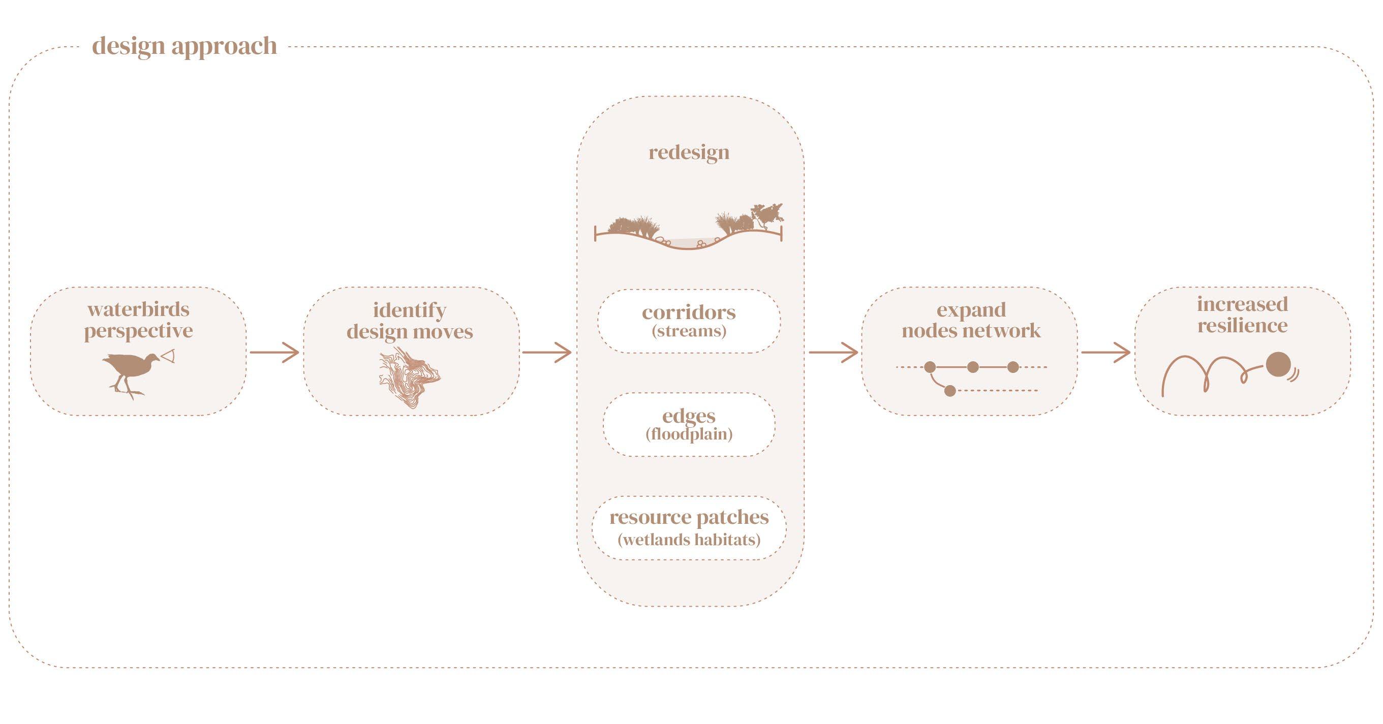
The design approach for this proposed hydrological framework centers empathy for native Hawaiian waterbirds and employs landscape ecology concepts to craft hydrological conditions that foster resilience. Under this approach, the landscape and ecological needs of the Hawaiian waterbirds are put first: these needs a used to inform specific design moves that will allow the waterbirds to perform their full range of ecosystem functions. Being empathetic towards the waterbirds needs, aims to improve hydrological systems at a bird scale, and ultimately aims to increase the urban environment’s capacity to bounce back when facing flooding conditions, i.e. building resilience.
Building resilience through this approach requires operating at various scales, hence, while the overall framework for a new hydrological network derives from landscape ecology concepts, the physical designs emerge from a combination of these concepts and from harnessing the perspective and needs of the native Hawaiian waterbirds community selected for this project. This design approach claims that, at the urbanscape scale, landscape ecology concepts create a network of nodes and corridors for flood diffusion. At the site scale, the landscape needs of the waterbirds are the primary catalysts for design. Under this approach, the primary ecological functions of the waterbirds are first identified: foraging, nesting, and loafing
(i.e. an idle or rest state). The physical landscape conditions and elements that are needed for the waterbirds to perform these ecological functions, are then compiled and used to inform specific landscape design moves.
The overall design strategy was based on two primary goals. First to uncover the natural hydrology by removing some of the constraints on the waterway, and second to champion richness of bio and cultural diversity by remediating erasure of wetland habitats. The design elements identified though analysis of the landscape needs of the community of waterbirds’ were used in concert with concepts of landscape ecology to create


specific design interventions. The result of this process is a gradient of hydrological conditions from stream to natural and cultural patches to floodplain, transpiring through greened streams, new floodplain conditions, wetlands conditions, and vegetated buffers.
The landscape needs of the ‘Ae‘o, ‘Alae ke‘oke‘o, ‘Alae ‘ula, and Koloa maoli, were assessed and drawn from a conversation with experts at the Department of Fish and Wildlife Service, and from the state’s conservation plans and supportive literature (U.S. Fish and Wildlife Service). Overall, all four of these birds depend on dense and emerging vegetation, water levels under 9-12”, changing microtopography consisting of series of mounts and basins, as well as a community of wetland plants to perform their natural ecosystem functions. The waterbird’s landscape needs were interpreted and translated into a series of design elements: expanded floodplain, changing microtopography and hydrology, emergent vegetation plantings, vegetated buffers, and cultural plantings. These design elements aim to support natural ecosystem functions and to ultimately generate ecosystem services.
To study the viability of this approach, this project focused on of Mānoa Valley, specifically Mānoa Stream.

The Ala Wai watershed, in the Waikīkī Ahupua‘a, which extends from the top of the Ko‘olau Mountain Range to Waikīkī, is the primary juncture for current and predicted flooding. Mānoa Stream, which runs across the entirety of Mānoa Valley is nested right at the center of the watershed. Much like the rest of the streams in Honolulu, Mānoa Stream has been substantially modified and channelized, which negates the rich hydrological history of the Valley.
Before European development, rice fields and lo‘i kalo were scattered around the valley, extending from the stream well into the natural floodplain. The stream was likely wider, and vegetated with native plant communities. The erasure of these conditions not only rendered the area vulnerable to frequent flooding but also created a rather homogeneous landscape with little biodiversity. The homogeneity of the landscape simultaneously renders the distinction between patches, edges, and corridors almost impossible and hampers its capacity for resilience.
The proposed design interventions place the streams as the first phase of this new hydrological network to ensure connectivity and serve as the first level for mitigation. The design aspect of the project focuses on utilizing Mānoa Stream as a study site. To do so, the project inventories the various edge conditions along Mānoa Stream and proposes design interventions that re-center the needs of the waterbirds.
The present stream conditions along Mānoa stream can be classified under three primary categories: constrained with an adjacent floodplain, channelized with riparian edges and hard bottom, and entirely channelized flanked by two retaining walls. Repeating the same previous process as for the PUC, spatial analysis of historic and forecasted conditions points to several public areas and parks along the stream that can be used as hydrological nodes to be integrated within this new hydrological network.
The conditions at these parks can be categorized under two primary conditions: a floodplain adjacent to the stream bed, which can be re-designed into a resource patch, within the high-risk flood zone, and a drier edge that may receive intermittent flooding. Mānoa Valley District Park is a public recreational park and is one of the potential resource patches, and The conditions of the park from floodplain to intermittent flooding edges illustrate the typological conditions of landscape nodes that exist throughout the PUC.

The Ala Wai watershed, in the Waikīkī Ahupua‘a, which extends from the top of the Ko‘olau Mountain Range to Waikīkī, is the primary juncture for current and predicted flooding.
Adapted from State of Hawai‘i, Office of Planning.

from State
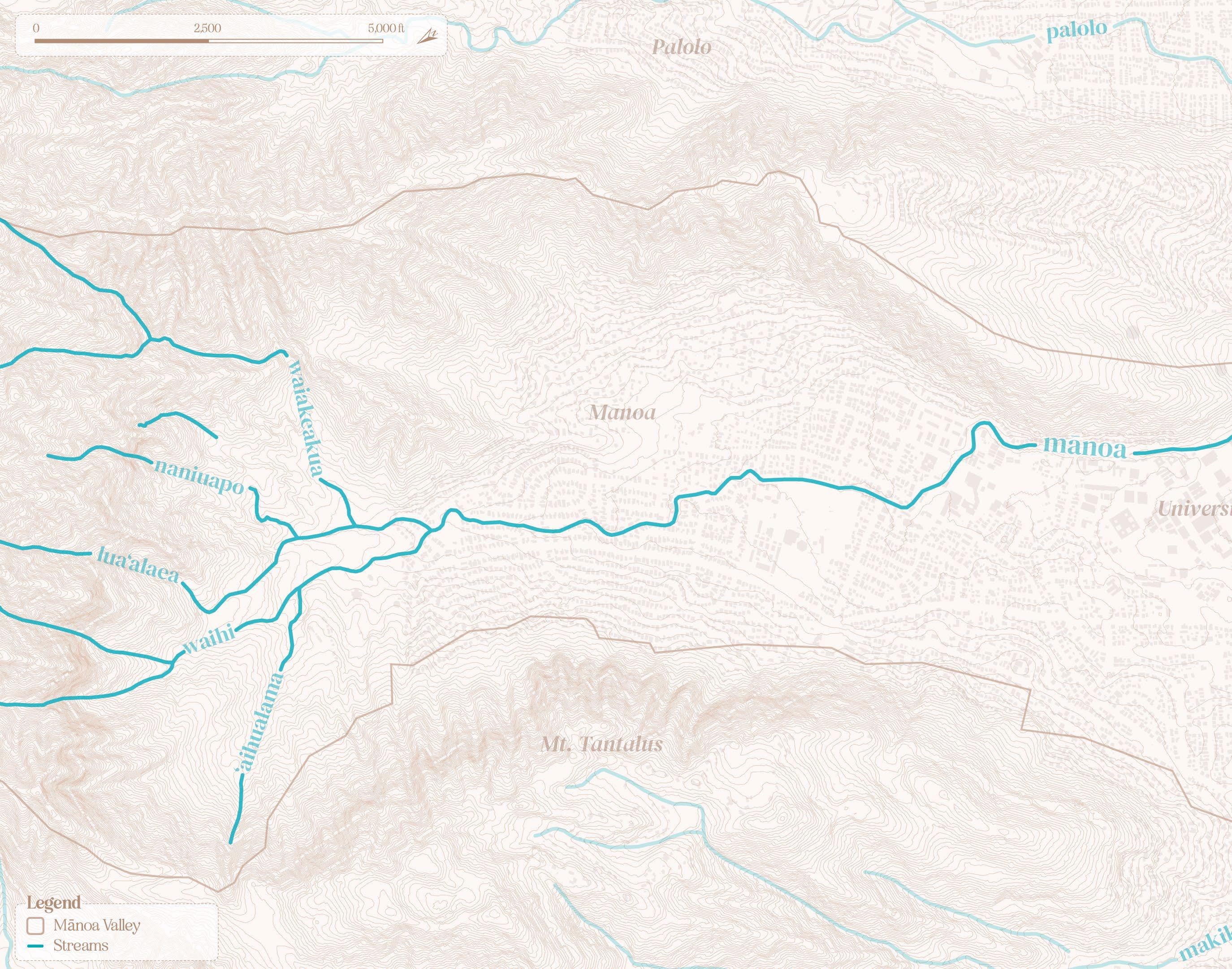

Mānoa Stream
Mānoa Stream runs across the entirety of Mānoa Valley. Adapted from State of Hawai‘i,


Mānoa Valley in 1893
Depicting the presence of lo‘i kalo and rice fields throughout the valley. Adapted from State of Hawai‘i,


Mānoa Valley hydrological fluctuations
Illustration of the impacts of sea-level rise, 100-year floor, and 500-year flood on Mānoa Valley. Adapted from State of Hawai‘i,


Mānoa Valley intervention opportunities location
The objective is to apply the landscape guidelines learned from the study of the Hawaiian waterbirds and the principles of landscape ecology to reenvision Mānoa Stream and Mānoa Valley District Park as corridors and resource patches, respectively.


Public parks around Mānoa Valley
Identifying public parks throughout the valley and along Mānoa stream, and categorizing the different stream conditions: constrained with an adjacent floodplain, channelized with riparian edges and hard bottom, and entirely channelized with retaining wall.

Hydrological network’s plant palette
The proposed plant palette for the new hydrological network would be composed of native wetland vegetation. The plant selection was built around species that the community of native Hawaiian waterbirds relies on.
The proposed design suggests organizing the planting in a gradient of moisture conditions. For basins and stream beds, clusters of floating vegetation, and emergent vegetation would be integrated. Waterbird-specific and culturally specific plants can be integrated into the resource patches, depending on the preferred use.
Riparian clusters can serve as buffers between the resource patches and the dry and native grasses edge.
The canopy would be adapted to elevation but could be composed of six primary trees that would be placed according to their moisture tolerance.


A. Stream conditions: existing constrained stream with adjacent floodplain
The streambed is constrained to a small area. The stream edges are vegetated mostly with invasive plants and little to no native vegetation. Some of the waterbirds may be present, such as hybrid mallardkoloa maoli and ‘auku‘u. The park edge offers little shade and is vegetated with mowed lawn.

Adapted from State of Hawai‘i, Office of Planning

A. Stream conditions: Proposed expanded streambed and floodplain
The proposed design would re-integrate the stream into the hydrological nodes, expanding its edges to allocate space for natural water fluctuations, Microtopography would be integrated to satisfy the waterbirds’ needs, so that they can perform their ecosystem functions and generate ecosystem services that mitigate flooding, such as erosion control. Finally, careful consideration should be brought to the plant palette to ensure that the community of waterbirds can perform the full range of its ecosystem functions. The vegetation should be organized in a gradient, from floating to riparian plants and planted to create a buffer from surrounding land uses. Additional features such as a boardwalk could be integrated for enhanced recreational and educational opportunities.

Adapted from State of Hawai‘i, Office of Planning

B. Stream conditions: Existing channelized stream with naturalized edges
While some vegetation and biodiversity may exist on the edge of the stream, the stream bed is channelized. The concrete bottom prevents natural systems and functions, such as groundwater recharge. The conditions of the stream are also not conducive for waterbirds to perform their ecosystem functions.

Adapted from State of Hawai‘i, Office of Planning

B. Stream conditions: Proposed naturalized stream
Under these conditions the hard concrete bottom would be removed, to re-integrate opportunities for emergent vegetation. The re-introduced vegetation would allow waterbirds to forage and loaf in the stream streambed. A natural stream bed would also allow to restore water percolation and contribute to groundwater recharge. Small in-water islands should be integrated to simultaneously restore biodiversity and slow down the water flow. Riparian edges would be re-vegetated with native plants that are conducive to the waterbirds’ needs.

Adapted from State of Hawai‘i, Office of Planning

C. Stream conditions: Existing channelized stream with retaining walls
The retaining walls and hard bottom present a challenge for waterbirds to perform their natural ecosystem functions. Additionally, the velocity of the water tends to be higher in channelized streams, preventing vegetation to be well-established.

Adapted from State of Hawai‘i, Office of Planning

C. Stream conditions: Proposed greened stream
For the channelized streams where retaining walls cannot be removed, small terraces would be integrated along the wall. These terraces would allow for partial capture and filter non-point source pollution from the urban edge. In areas where landowners may be willing to remove the retaining wall, larger terraces would be integrated to perform similar filtering functions and improve the water quality of the stream. The concrete bottom of the stream would be removed and replaced by small inwater islands to restore biodiversity and slow down water flow.

Adapted from State of Hawai‘i, Office of Planning
Stream conditions: Waterbirds scale
Waterbirds would be the architects of these proposed stream conditions. While the water movement, may not allow to provide the necessary conditions for the birds the perform the full range of their ecosystem functions, the new in-stream islands would allow the waterbirds to forage, graze, and loaf. Creating the appropriate conditions for these waterbirds would result in improved environmental conditions, and ultimately restore ecosystem services.
Adapted from State of Hawai‘i, Office of Planning


Node conditions:
Location of Mānoa Valley District Park, at the intersection of historical wetlands and hydrological floodplain.
Adapted from State of Hawai‘i, Office of Planning; Wall
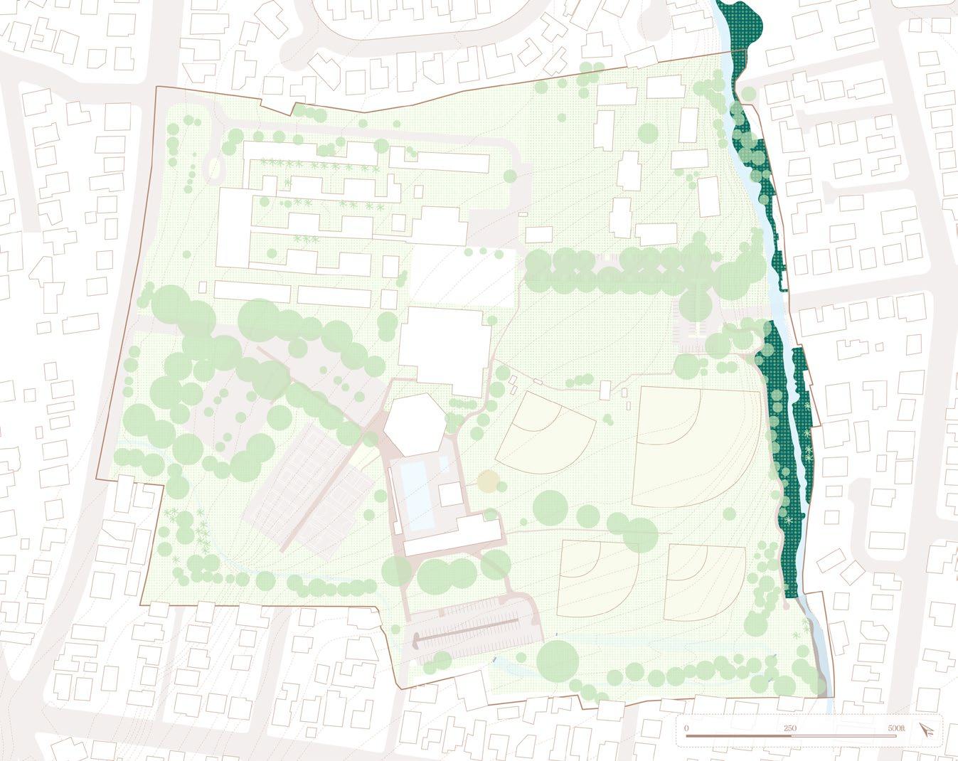

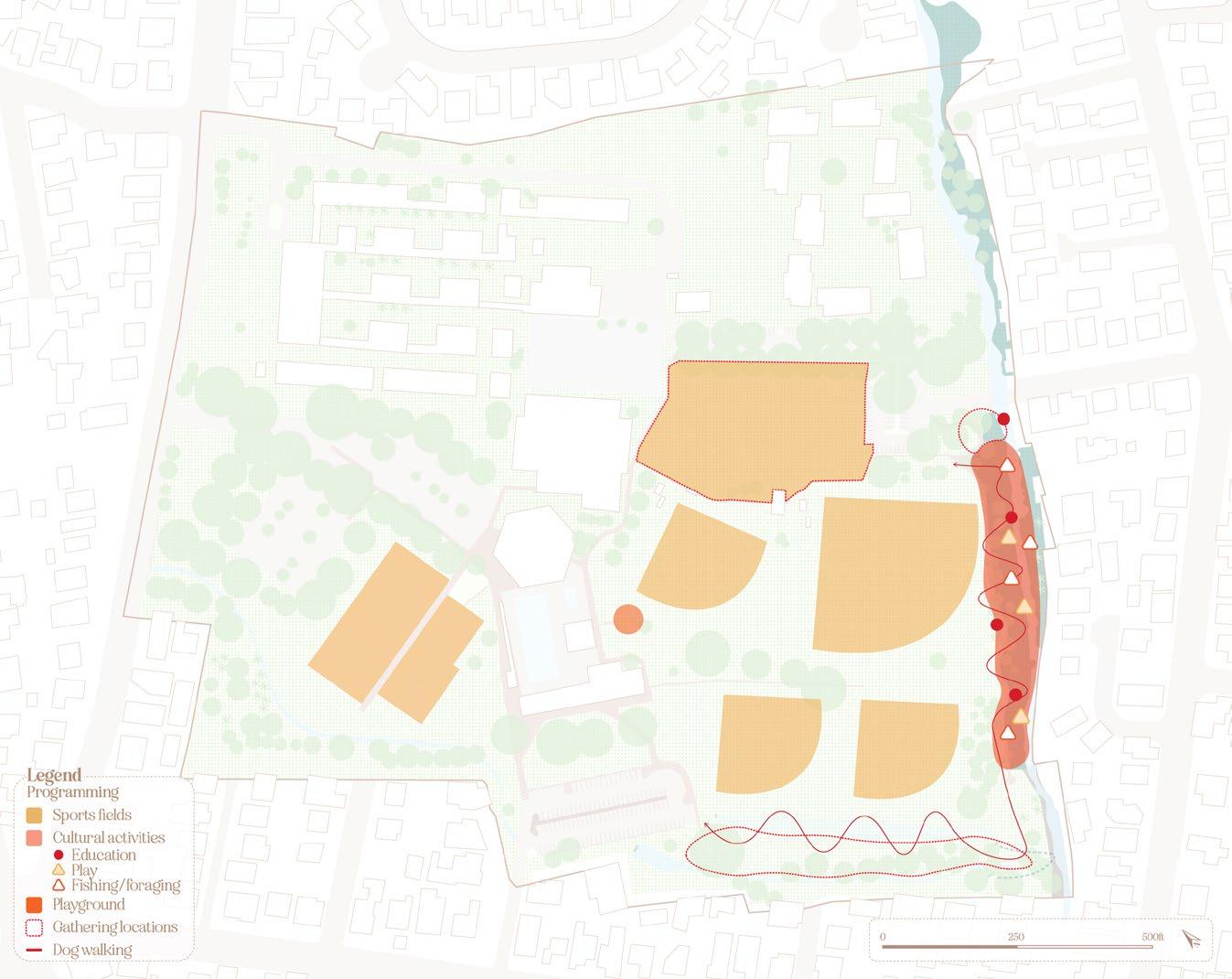


Node conditions: Site analysis
The site analysis of the park revealed a handful of programming types; the site is primarily dedicated to sports fields, with four baseball fields and one open area for soccer within the open lawn area. Other parkgoers will tend to gather on the southwest edge of the site or around the stream for dog walking and to perform cultural and social activities. The site is also often used by schools and the University of Hawai‘i at Mānoa for field visits and other educational opportunities.
However, this programming is almost entirely dissociated from biological or hydrological natural processes. Indeed, the vegetation of the site
is rather heterogeneous, with mowed lawn as the primary ground cover, and a large amount of intruded and invasive plant species around the stream. The stream is also the only primary hydrological resource, sometimes fed by two smaller swales running from the northwest side of the property through a series of culverts. Further analysis of hydrological conditions reveals that the park is located within a high-risk flood zone, with the 100-year rain events’ floodplain taking over about half of the main lawn and the 500-year floodplain almost taking over the entire lawn. Up until the last decade, the probability of extreme rain events was much more accurately represented by the term
“100-year flood”, however, climate change has increased the frequency and probability of these events. Mānoa Stream now experiences flooding rather regularly. The U.S. Geological Survey’s water gauge at Woodlawn Drive recorded an average of 3.5 feet increase in water levels following any rain event, with some events reaching up to almost 8 feet since the beginning of 2023.

Proposed design area
Node conditions: Proposed design
The site analysis for Mānoa Valley District Park, specifically the location of the flood zone, delineated the intervention area. The design of this resource node proposes to reclaim the flood zone as the natural floodplain and create new topographic moves intended to simultaneously provide habitat and allocate space for hydrologic movements. Designing in a gradient from the stream into the site, the stream bed would be redirected and expanded to emulate natural water movement and move riparian conditions further inland. A new natural resource patch, that includes some micro-topography in the form of shallow basins and small mounts, would be integrated to act as a
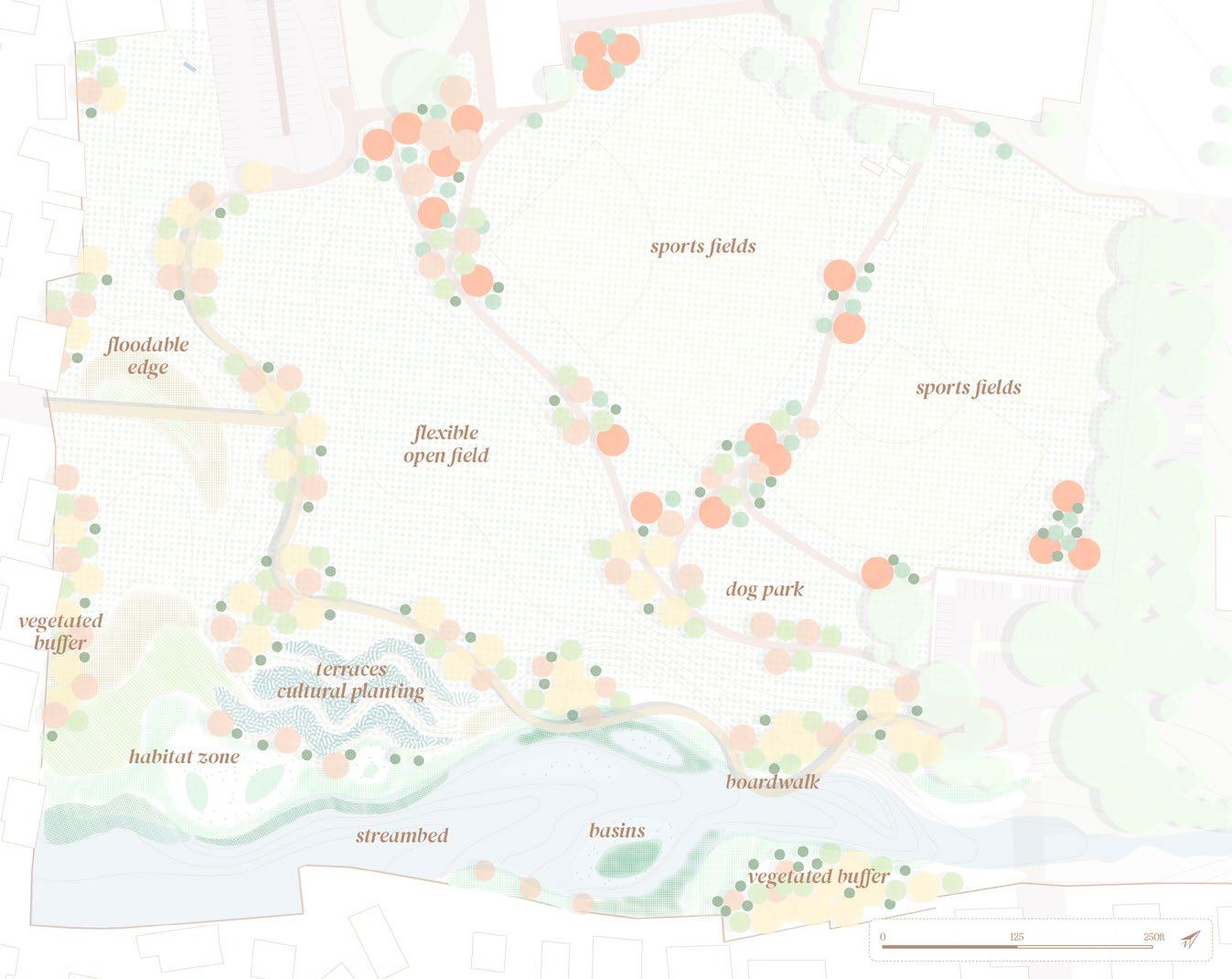
Proposed programming
wetland habitat and buffer park activities. Moving inland a dry edge would be created to emulate the landscape needs of the ‘ae‘o, which prefers lower and drier vegetation, and create a flexible floodable space for large storm events overflow. Right above the stream and resource patch, a new cultural patch would be integrated to support cultural and education practices. It would take the form of three terraces and be vegetated with culturally significant plants. The area above the stream and cultural patch would remain an open field to continue to provide recreational and sports opportunities. Finally, a new dog park would be added to ensure that the natural resource patch retains some
protection from species that are likely to harm the community of waterbirds. Additionally, the design offers new consideration for the channelized part of the stream, by suggesting the removal of gray infrastructure and integration of nature-based solutions in its place.


A. Node conditions: Existing stream-adjacent floodplain
Existing conditions are a rather homogeneous landscape, with mowed-lawn and low biodiversity. The programming consists mostly of open/sports fields, with few opportunities for people and waterbirds alike.

Adapted from State of Hawai‘i, Office of Planning
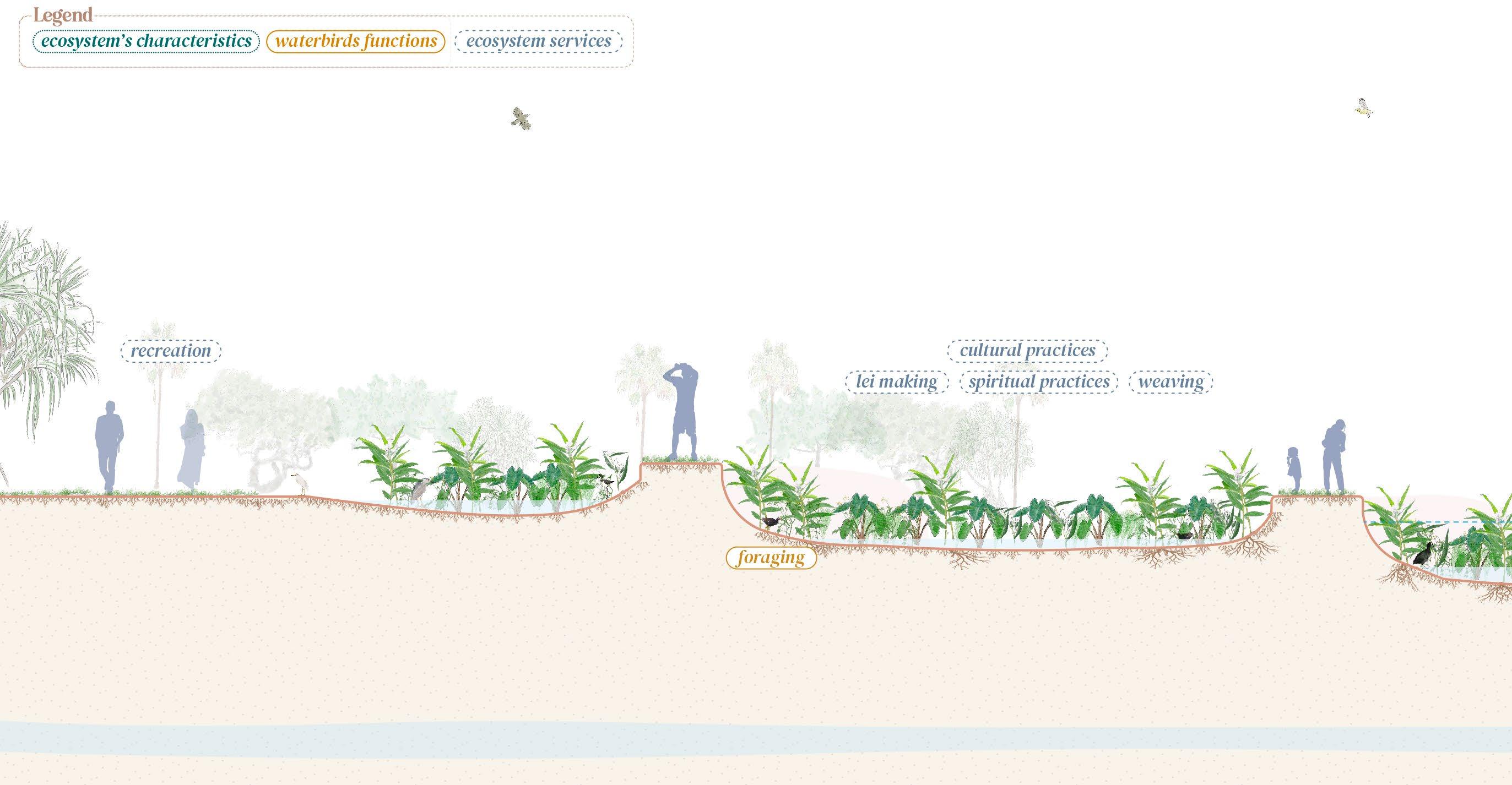
A. Node conditions: Proposed cultural and resource patches
The new cultural and resource patches focus on restoring the ecological functions of the floodplain while providing both habitat and opportunities for cultural practices. The terraces are planted with culturally relevant plants, which offer educational opportunities as well as spiritual and cultural practices opportunities such as weaving or lei making. The terraces can operate as a community garden but also welcome flooding during storm events. The resource patch below is restricted to waterbirds and other wetland land species. It is composed of small basins and mounts to ensure that the waterbirds can nest, forage, graze, and loaf.

Adapted from State of Hawai‘i, Office of Planning
A. Nodes conditions: Cultural patch and terraces
For the channelized streams where retaining walls cannot be removed, small terraces would be integrated along the wall. These terraces would allow for partial capture and filter non-point source pollution from the urban edge. In areas where landowners may be willing to remove the retaining wall, larger terraces would be integrated to perform similar filtering functions and improve the water quality of the stream. The concrete bottom of the stream would be removed and replaced by small inwater islands to restore biodiversity and slow down water flow. ultimately restore ecosystem services.
Adapted from State of Hawai‘i, Office of Planning

A. Nodes conditions: Resource patch
The resource patch would provide all of the necessary conditions for the waterbirds to perform their full ecosystem functions. With dense vegetation for nesting, foraging, and small in-water islands and rocks for loafing. Allowing the waterbirds to perform their ecosystem functions would generate positive outcomes for the ecosystem, such as increased nutrients and biodiversity.
Adapted from State of Hawai‘i, Office of Planning


B. Nodes conditions: Existing dry edge
Existing conditions on the floodplain edge are similar to the rest of the park; centered around sports fields and open mowed lawns. Biodiversity is not rich, and the lack of canopy cover does not make for a welcoming environment for parkgoers.

Adapted from State of Hawai‘i, Office of Planning

B. Nodes conditions: Proposed floodable edge
The new floodable edge allows the preservation of the existing open fields but re-envisions them to provide more flexibility to parkgoers. The new design would allow the open fields to be used for sports events and gathering during dry events but would serve as a retention basin during storm events, allowing to capture and slow down runoff.

Adapted from State of Hawai‘i, Office of Planning
B. Node conditions: Floodable dry edge
For the channelized streams where retaining walls cannot be removed, small terraces would be integrated along the wall. These terraces would allow for partial capture and filter non-point source pollution from the urban edge. In areas where landowners may be willing to remove the retaining wall, larger terraces would be integrated to perform similar filtering functions and improve the water quality of the stream. The concrete bottom of the stream would be removed and replaced by small inwater islands to restore biodiversity and slow down water flow.
Adapted from State of Hawai‘i, Office of Planning


The combination of this research’s design concepts provides new considerations for the management and integration of hydrological resources in the urban fabric. The design process applied throughout this project allowed the revealing of a series of opportunities for the implementation of a new hydrological network centered around addressing climate-change-related flooding and storm events. While some limitations, such as availability of properties, financial cost, or potential pushback from the community remain to be addressed, the study sites began to shed light on the opportunities that are already existing in the urban realm. Manoa Stream and Manoa Valley District Park capture some of the typical conditions of streams and floodplains found around Honolulu, and studying these various typologies allowed us to propose replicable design interventions.
To create this hydrological network, this research argued for the implementation of a more empathetic approach by utilizing the perspective of native Hawaiian birds to inform design. By creating landscapes that are empathetic, and that are inclusive of other species’ needs, designers, planners, and all urban actors can begin to restore ecosystem functions that are essential for resilience. Furthermore, an empathetic approach to design not only encourages the various actors of the urban realm to pay attention to the surrounding biodiversity but also encourages people to appreciate the intrinsic value of these discrete ecosystem architects.

Adla, Kahrić, et al. “Chapter 9 - Degradation of Ecosystems and Loss of Ecosystem Services.” One Health, edited by Joana C. Prata et al., Academic Press, 2022, pp. 281–327. ScienceDirect, https://doi. org/10.1016/B978-0-12-822794-7.00008-3.
Akhtar, Muizz. “Too Many Americans Live in Places Built for Cars — Not for Human Connection.” Vox, 25 Aug. 2022, https://www.vox.com/features/23191527/ urban-planning-friendship-houston-carsloneliness.
Bai, Xuemei, et al. “Linking Urbanization and the Environment: Conceptual and Empirical Advances.” Annual Review of Environment and Resources, vol. 42, no. 1, Oct. 2017, pp. 215–40. DOI.org (Crossref), https:// doi.org/10.1146/annurev-environ-102016-061128.
Begum, Tammana. “How Listening to Birdsong Can Transform Our Mental Health.” Natural History Museum, 8 Oct. 2020, https://www.nhm.ac.uk/ discover/how-listening-to-bird-song-cantransform-our-mental-health.html.
Boix, Dani, et al. Conservation of Temporary Wetlands. 2019. pubs.er.usgs.gov, https://doi. org/10.1016/B978-0-12-409548-9.12003-2.
ByBi and Norwegian Environment Agency. “Pollinatorpassasjen.” Pollinatorpassasjen, http:// www.pollinatorpassasjen.no. Accessed 26 Jan. 2023.
Calhoun, Aram J. K., et al. “Temporary Wetlands: Challenges and Solutions to Conserving a ‘Disappearing’ Ecosystem.” Biological Conservation, vol. 211, July 2017, pp. 3–11. DOI.org (Crossref), https:// doi.org/10.1016/j.biocon.2016.11.024.
Collins, Katie. “Oslo Plants ’bee Highways to Protect Urban Pollinators.” Wired UK | Condé Nast. www. wired.co.uk, https://www.wired.co.uk/article/beehighways-oslo. Accessed 26 Jan. 2023.
Costanza, Robert, et al. “The Value of the World’s Ecosystem Services and Natural Capital.” Nature, vol. 387, no. 6630, 6630, May 1997, pp. 253–60. www.nature.com, https://doi.org/10.1038/387253a0. Daily, Gretchen C. Nature’s Services: Societal Dependence On Natural Ecosystems. Island Press, 1997.
de Groot, Rudolf, et al. A Typology for the Classification Description and Valuation of Ecosystem Functions, Goods and Services. Feb. 2022, https://www. researchgate.net/publication/297563783_A_ Typology_for_the_Classification_Description_ and_Valuation_of_Ecosystem_Functions_Goods_ and_Services.
Erickson, Terrell Ann, and Christopher F. Puttock. Hawai’i Wetland Field Guide: An Ecological and Identification Guide to Wetlands and Wetland Plants of the Hawaiian Islands. U.S. Environmental Protection Agency, 2006.
Fang, Yu, and James W. Jawitz. “The Evolution of Human Population Distance to Water in the USA from 1790 to 2010.” Nature Communications, vol. 10, Jan. 2019, p. 430. PubMed Central, https://doi. org/10.1038/s41467-019-08366-z.
Fernández-Juricic, Esteban, and Jukka Jokimäki. “A Habitat Island Approach to Conserving Birdsin Urban Landscapes: Case Studies from Southernand Northern Europe.” Biodiversity and Conservation, vol. 10, no. 12, 2001, pp. 2023–43. DOI.org (Crossref), https://doi.org/10.1023/A:1013133308987.
Food and Agriculture Organization of the United Nations. “Ecosystem Services & Biodiversity (ESB).” Food and Agriculture Organization of the United Nations, http://www.fao.org/ecosystem-servicesbiodiversity/en/. Accessed 19 Mar. 2023.
Forest Service, USDA. Palustrine Process Group. U.S. Department of Agriculture. Zotero, https:// www.fs.usda.gov/Internet/FSE_DOCUMENTS/ stelprdb5413817.pdf.
GEOBON. “Ecosystem Function.” GEO BON, https:// geobon.org/ebvs/working-groups/ecosystemfunction/. Accessed 7 May 2023.
Green, Andy J., and Johan Elmberg. “Ecosystem Services Provided by Waterbirds.” Biological Reviews, vol. 89, no. 1, Feb. 2014, pp. 105–22. DOI.org (Crossref), https://doi.org/10.1111/brv.12045.
Hawai‘i State Office of Planning. Hawaii Statewide GIS Program. https://geoportal.hawaii.gov/. Accessed 8 Mar. 2023.
Hu, Shengjie, et al. “Global Wetlands: Potential Distribution, Wetland Loss, and Status.” Science of The Total Environment, vol. 586, May 2017, pp. 319–27, https://doi.org/10.1016/j.scitotenv.2017.02.001.
Itzkowitz, Laura. “5 Definitive Ways to Create Better Cities.” Architectural Digest, 1 Mar. 2021, https:// www.architecturaldigest.com/story/definitiveways-create-better-cities.
Landscape Ecology - an Overview | ScienceDirect Topics. https://www.sciencedirect.com/topics/ earth-and-planetary-sciences/landscape-ecology. Accessed 28 Apr. 2023.
Lawler, Sharon Patricia. “Rice Fields as Temporary Wetlands: A Review.” Israel Journal of Zoology, vol. 47, no. 4, Jan. 2001, pp. 513–28. Taylor and Francis+NEJM, https://doi.org/10.1560/X7K3-9JG8MH2J-XGX1.
Lyons, Alexander. Map of Oahu. 1881. UH MAGIS. Manoa Stream at Woodlawn Drive, Oahu, HI. https:// waterdata.usgs.gov/monitoring-location/16241600/. Accessed 29 Apr. 2023.
McGill and World Wildlife Fund. “Wetlands.” Resource Watch, https://resourcewatch.org/data/ explore. Accessed 27 Feb. 2023.
Meadows, Donella. Thinking in Systems: International Bestseller. Chelsea Green Publishing, 2008.
National Geographic. “These Animals Offer Key Clues for Environmental Change.” National Geographic | Animals, 17 Sept. 2021, https://www. nationalgeographic.com/animals/article/theseanimals-offer-key-clues-for-environmentalchange.
Pacific Rim Conservation. Hawaiian Bird Conservation Action Plan: Hawaiian Duck or Koloa Maoli (Anas Wyvlliana). Pacific Rim Conservation, Oct. 2012, https://pacificrimconservation.org/wpcontent/uploads/2013/10/Koloa.pdf.
Pinkham, L. E. Reclamation of the Waikiki District of the City of Honolulu, Territory of Hawaii: Recommendations, Maps, Plans and Specifications. Board of Health, Territory of Hawaii, 26 Feb. 1906.
Pyle, Robert L., and Peter Pyle. Hawaiian Duck, Anas Wyvilliana. Hawaii Biological Survey, Bishop Museum, 1 Jan. 2017, http://hbs.bishopmuseum.org/birds/rlpmonograph/.
Ramsar. “75% of Earth’s Land Areas Are Degraded; Wetlands Have Been Hit Hardest, with 87% Lost Globally in the Last 300 Years | Convention on Wetlands.” Ramsar, 27 Mar. 2018, https://www. ramsar.org/news/75-of-earths-land-areas-aredegraded-wetlands-have-been-hit-hardest-with87-lost-globally-in.
Reed, Chris, and Nina-Marie Lister. Projective Ecologies. Harvard Graduate School of Design, 2014.
Ritchie, Hannah, and Max Roser. “Urbanization.” Our World in Data, June 2018. ourworldindata.org, https://ourworldindata.org/urbanization.
SCAPE Studio. “Public Sediment: Resilient By Design Challenge.” SCAPE, https://www.scapestudio. com/projects/public-sediment-resilient-designchallenge/. Accessed 26 Jan. 2023.
Shull, D. H. “Bioturbation.” Encyclopedia of Ocean Sciences (Second Edition), edited by John H. Steele, Academic Press, 2009, pp. 395–400. ScienceDirect, https://doi.org/10.1016/B978-012374473-9.00656-1.
Siddig, Ahmed A. H., et al. “How Do Ecologists Select and Use Indicator Species to Monitor Ecological Change? Insights from 14 Years of Publication in Ecological Indicators.” Ecological Indicators, vol. 60, Jan. 2016, pp. 223–30. DOI.org (Crossref), https:// doi.org/10.1016/j.ecolind.2015.06.036.
Spencer, Sierra. “Anas Wyvilliana (Hawaiian Duck).” Animal Diversity Web, https://animaldiversity.org/ accounts/Anas_wyvilliana/. Accessed 7 Mar. 2023.
State of Hawai‘i, Department of Land and Natural Resources, Division of Forestry and Wildlife. Hawai‘i’s State Wildlife Action Plan: Koloa Maoli or Hawaiian Duck. State of Hawai‘i, 1 Oct. 2015, p. (7)106(7)108. Zotero, https://dlnr.hawaii.gov/wildlife/ files/2020/07/HI-SWAP-2015-FINAL.pdf.
---. Hawaii’s Wetlands, Mauka to Makai: An Introduction to Wetlands in Hawai‘i. State of Hawai‘i, 2009, https://dlnr.hawaii.gov/wildlife/files/2020/08/ WetlandBrochure.pdf.
---. “Wetlands of Hawai‘i: Mauka to Makai.” Wetlands of Hawai‘i, 5 Mar. 2021, https://storymaps.arcgis.com/ stories/953e394bb1864929bc687b215614aa68.
State of Hawai‘i, Office of Planning and Sustainable Development. Hawaii’s Coastal Nonpoint Pollution Control Program Management Plan. June 1996.
Studio Gang. “Ford Calumet Environmental Center.” Studio Gang | Projects, https://studiogang.com/ project/ford-calumet-environmental-center. Accessed 26 Jan. 2023.
Sturm, Melanie. “Stewardship of Wetlands and Soils Has Climate Benefits.” Natural Resources Defense Council (NRDC), 30 Sept. 2019, https://www.nrdc. org/experts/melanie-sturm/stewardship-wetlandsand-soils-has-climate-benefits.
The Intergovernmental Panel on Climate Change (IPCC). AR4 Climate Change 2007: Impacts, Adaptation, and Vulnerability. IPCC, https://www. ipcc.ch/report/ar4/wg2/. Accessed 5 Mar. 2023.
The Nature Conservancy, Conservation Gateway. Wetland Classification Systems. The Nature Conservancy, https://www.conservationgateway. org/ConservationByGeography/NorthAmerica/ UnitedStates/nevada/water/Documents/wetland_ class_descr.pdf. Accessed 4 Feb. 2023.
“The Pacific Islands: The Front Line in the Battle against Climate Change.” NSF - National Science Foundation, https://beta.nsf.gov/science-matters/ pacific-islands-front-line-battle-against-climate. Accessed 17 Mar. 2023.
United Nations. “World Wetlands Day.” United Nations, United Nations, https://www.un.org/en/ observances/world-wetlands-day. Accessed 8 May 2023.
United Nations Climate Change. “Wetlands Disappearing Three Times Faster than Forests | UNFCCC.” United Nations Climate Change, 1 Oct. 2018, https://unfccc.int/news/wetlandsdisappearing-three-times-faster-than-forests.
United Nations, Department of Economic and Social Affairs. “68% of the World Population Projected to Live in Urban Areas by 2050, Says UN.” United Nations Department of Economic and Social Affairs, News, 16 May 2018, https://www.un.org/ development/desa/en/news/population/2018revision-of-world-urbanization-prospects.html.
---. “World Urbanization Prospects.” United Nations, https://population.un.org/wup/Download/. Accessed 27 Feb. 2023.
---. Green and Gray Infrastructure Research. 5 Jan. 2022, https://www.epa.gov/water-research/greenand-gray-infrastructure-research.
---. “What Is a Wetland? And Eight Other Wetland Facts.” World Wildlife Fund, https://www. worldwildlife.org/stories/what-is-a-wetland-and8-other-wetland-facts. Accessed 5 Mar. 2023.
United Nations, Population Division. “Urban Population (% of Total Population), Data.” The World Bank, https://data.worldbank.org/indicator/SP.URB.
TOTL.IN.ZS. Accessed 5 Mar. 2023.
United States Environmental Protection Agency (EPA). Types of Wetlands. EPA, Sept. 2021. Zotero, https://www.epa.gov/sites/default/files/2021-01/ documents/types_of_wetlands.pdf.
---. Urbanization - Overview. 3 Nov. 2015, https:// www.epa.gov/caddis-vol2/urbanization-overview. University of Hawai‘i. Ahupua’a. https://www2.hawaii. edu/~dhonda/ahupua%27a.htm. Accessed 8 May 2023.
Unknown. Nuuanu Stream. Photograph, https:// digitalarchives.hawaii.gov/item/ark:70111/2ll9. Hawai‘i State Archives, PNL-214-19582. Accessed 6 Mar. 2023.
---. Old Road to Waikiki. Photograph, https:// digitalarchives.hawaii.gov/item/ark:70111/1Fr0. Hawai‘i State Archives, PPWD-19-7-035. Accessed 27 Feb. 2023.
---. Pearl Harbor - 1920’s-1930’s. Photograph, 1930 1920, https://digitalarchives.hawaii.gov/item/ ark:70111/09st. Hawai‘i State Archives, PP-66-5003.
---. Pearl Harbor - n.d. Earliest to 1910’s. Photograph, https://digitalarchives.hawaii.gov/item/ ark:70111/09sl. Hawai‘i State Archives, PP-66-4-011. Accessed 27 Feb. 2023.
---. Stream Bed. Photograph, https://digitalarchives. hawaii.gov/item/ark:70111/2kKk. Hawai‘i State Archives, GPNBAK-6-172. Accessed 6 Mar. 2023. US EPA, ORD. Ecological Condition. 1 Nov. 2017, https://www.epa.gov/report-environment/ ecological-condition.
US EPA, OW. Manage Flood Risk. 1 Oct. 2015, https:// www.epa.gov/green-infrastructure/manage-floodrisk.
---. Why Are Wetlands Important? 9 Apr. 2015, https://www.epa.gov/wetlands/why-are-wetlandsimportant.
U.S. Fish and Wildlife Service. Recovery Plan for Hawaiian Waterbirds.
U.S. Geological Survey. The 100-Year Flood | U.S. Geological Survey. https://www.usgs.gov/specialtopics/water-science-school/science/100-yearflood. Accessed 8 May 2023.
van Rees, Charles, and Michael J. Reed. Wetland Loss in Hawai’i Since Human Settlement. Apr. 2014, https://doi.org/10.1007/s13157-013-0501-2.
Waikīkī Streams. 24 Feb. 2023, https:// imagesofoldhawaii.com/waikiki-streams/.
Wall, W. A. Map of Honolulu and Vicinity. 1883.
Wang, Yanping, et al. “A Global Synthesis of the Small-Island Effect in Habitat Islands.” Royal Society Publishing, no. 285, https://doi.org/10.1098/ rspb.2018.1868. Accessed 30 Jan. 2023.
Whelan, Christopher J., et al. “Ecosystem Services
Provided by Birds.” Annals of the New York Academy of Sciences, vol. 1134, no. 1, 2008, pp. 25–60. Wiley Online Library, https://doi.org/10.1196/ annals.1439.003.
World Wildlife Fund. “Global Lakes and Wetlands Database: Lakes and Wetlands Grid (Level 3).” World Wildlife Fund, https://www.worldwildlife. org/publications/global-lakes-and-wetlandsdatabase-lakes-and-wetlands-grid-level-3. Accessed 27 Feb. 2023.
Wu, Andrew. “Green versus Gray Infrastructure: The Economics of Flood Adaptation in Fiji.” Yale Environment Review, 11 Apr. 2017, https:// environment-review.yale.edu/green-versus-grayinfrastructure-economics-flood-adaptation-fiji-0.
Wu, J. “Landscape Ecology.” Encyclopedia of Ecology, edited by Sven Erik Jørgensen and Brian D. Fath, Academic Press, 2008, pp. 2103–08. ScienceDirect, https://doi.org/10.1016/B978008045405-4.00864-8.