Water in Hilo
The Island of Hawai i, known to many as Big Island, is far removed from the United States, geographically, in terms of climate, and in cultural practices/ ethos. Yet, the issues and grievances with water management are virtually the same. Too much, too little, too dirty.
Too Much
The small town of Hilo, sits on the East side of the island is at the forefront of these unprecedented changes. Its geographical windward positioning results in higher frequency of storms, tsunami risk, and high wind and wave energy exposure. Its bay faces directly into the trade winds and most incoming Northeast swells from the Alaska/ Aleutian Islands region.
In addition to the influence of water from the coastal front, Hilo is the rainiest city in the United States. Raining an average of 260 days of the year and over 130 inches a year in the lower watershed. In the upper reaches of Mauna Kea's forests, it can rain over 200 inches a year. It also has a substantial amount of freshwater reserves in the form of aquifers, springs, and streams. These bodies of water deposit billions of gallons of water and sediment into the bay annually. Groundwater is able to move from its upland aquifers to the bay quickly due to the geology of the island. Composed of mostly basalt, a porous igneous lava rock the Island of Hawai’i allows for infiltration and can hold large quantities of freshwater underground.
Too Little
In an attempt to control these climatic conditions and to further commerce, the lower watershed became impervious. Streams were channeled, aquifers covered,, Bayfront flattened and coastal fronts armored. This landscape scale change in surface cover prevents aquifer recharge, filtration of storm water runoff, and major flooding events. Through the process of paving the watershed we have separated our society from water. Aiming to keep it away from us and move it to the ocean as quickly as possible..
Too Dirty
In an attempt to control these climatic conditions and to further. To complicate this issue, the city's treatment of wastewater is extremely poor. The Hilo Wastewater Treatment Plant was constructed in the 90s and is outdated and in need of repairs. The county awarded the project a $337 million contract which is expected to take five years. Currently, it treats more than 3 millions gallons of wastewater a day and if it were to fail all of the sewage would enter the bay about 4,500 feet offshore. If residents are not connected to city sewer lines leading to the plant, they have cesspools. It's essentially a holding tank, and the waste gradually seeps into the surrounding soil. Unlike septic tanks, cesspools don't break down waste and can contaminate the ground and groundwater. Unfortunately, the geology in Hawai’i does not support conventional cesspools. Instead, the untreated wastewater leaches through the rock and into aquifers. More raw sewage eventually makes its way into the bay. Since the late 1970s, Hilo Bay's waters have failed to meet state water quality standards, particularly for nutrients, turbidity, and fecal bacteria. In 1998, the U.S. Environmental Protection Agency (EPA) officially


Left - Contaminated water warning posted by Department of Health after a sewage spill.
https://www.hawaiitribune-herald.com/201 7/04/05/hawaii-news/officials-continue-to -urge-caution-water-activities-in-several-p osted-areas-around-hilo-bay-still-should-be -avoided-following-monday-sewage-spill/
Above- Wailuku stream during Hurricane Lane in 2018. Photo by Jessica Henricks via AP.
Breakwater Typologies
Rubble Mound
Constructed by layering progressively larger stone or concrete units over a base of smaller rock, forming a sloped, porous structure. Their design effectively dissipates wave energy through internal friction, making them durable and flexible under changing sea conditions. However, they require a significant volume of material and space, which can drive up costs and increase their environmental footprint on the seabed. Navigation-wise, their broad form can obstruct visibility and approach paths, especially if the crest is overtopped in storms. These breakwaters typically use quarried rock, geotextiles, and specialized concrete units like tetrapods or dolosse for wave armor.

Also known as vertical wall breakwaters, consist of large prefabricated concrete boxes placed on a prepared foundation and filled with ballast. These rigid, upright structures occupy less seafloor area and can double as quay walls or roadways, making them spatially efficient and suitable for deep water. Their main drawbacks are high construction costs and a tendency to reflect wave energy rather than absorb it, which can cause turbulent conditions and scouring at the base. In terms of navigation, they provide a stable and clearly defined boundary but may worsen conditions in adjacent waters due to wave reflection. They are usually made of reinforced concrete, steel, and internal rock fill.

Buoyant structures—such as concrete pontoons or plastic modules—anchored to the seabed with chains or piles. They offer a low-impact solution suitable for marinas and sheltered waters, with the advantage of being relocatable and relatively quick to install. Their major limitation is reduced effectiveness in high-energy or storm-prone environments, as they struggle to absorb long-period, large waves. They pose minimal obstruction to navigation, which makes them useful where vessel access and flexibility are essential. Common materials include concrete, steel, rubber, and durable plastic composites.
https://www.webuildgroup.com/en/proj ects/dams-hydroelectric-plants/genoas-new-breakwater/
https://www.poh.usace.army.mil/Missi ons/Civil-Works/Civil-Works-Projects/ Hilo-Harbor/
https://sfmarina.com.tr/en/breakwaters/
Caisson breakwaters
Floating breakwaters
Left- Example of Cassion breakwater in Genoa. Photo by WeBuild.
Left - Rubble mound breakwater in Hilo.
Left- Floating aka concrete pontoons in Sweeden.
Detached breakwaters
Offshore structures built parallel to the shoreline but separated by a gap of open water, allowing waves to break before reaching the coast. Their form is typically a segmented or continuous low-crested structure made of rubble mound or precast concrete units. This design reduces wave energy, encourages sediment accumulation landward of the breakwater, and helps stabilize beaches over time. However, they can be costly to build and maintain, and if poorly designed, they may cause down-drift erosion or disrupt natural sediment transport. Navigationally, they require careful placement to avoid obstructing small vessel routes and must be clearly marked to prevent collisions. Materials commonly used include quarried stone, concrete armor units, and increasingly, eco-modular blocks that support marine life.
Reef breakwaters and 3D Printed Units
Reef balls and modular reef units are made from varying and innovative methods, including 3D printing. They are designed to mimic natural reef forms while providing shoreline protection and habitat enhancement. These units are highly customizable in shape, size, and configuration, making them adaptable to a range of site conditions and ecological goals. The main advantages include their low visual impact, ease of deployment, and ability to support coral growth, fish habitat, and water quality improvement. However, they are less effective than traditional breakwaters in high-energy environments and may require anchoring or grouping to achieve meaningful wave attenuation. Materials are primarily marine-grade concrete, often infused with additives to enhance coral recruitment and biological colonization.
Above- Hydrodynamic function of a submerged breakwater. https://www.researchgate.net/figure/S ubmerged-Permeable-Breakwater-Simu lation_fig1_370533899
Left- Ariel view of Living Breakwater Project Installation by SCAPE. https://econcretetech.com/projects/livi ng-breakwaters/
Submerged
Low-profile or fully submerged structures placed offshore, often designed to mimic natural reef forms. They reduce wave energy before it reaches the shore, with minimal visual impact and the potential to enhance marine habitat. On the downside, they are less effective against large or storm-driven waves and are difficult to monitor and maintain due to their underwater location. If poorly marked, they can also be hazardous to navigation, especially for deep-draft vessels. These breakwaters are typically constructed from rock, concrete, or artificial reef modules designed to support ecological functions.
https://www.reefdesignlab.com/marsii
Left- Modular Artificial Reef Structure II by Reef Design Lab in Melbourne Australia.
Living shorelines
Nature-based coastal protection strategies that use native vegetation, sand, and sometimes organic or structural elements to stabilize the shoreline. Unlike traditional hard structures, they mimic natural systems like marshes, mangroves, or dunes to buffer wave energy, trap sediment, and support biodiversity. The primary benefits include habitat creation, improved water quality, and resilience through self-repair and adaptation over time. However, their effectiveness is limited in high-energy environments or where wave forces exceed the capacity of vegetation to recover. They typically have minimal negative impacts on navigation, as they conform to the natural coastline and rarely extend far into the water column, but their performance depends heavily on local conditions like tidal range and sediment supply. Materials include native plants, coir logs, biodegradable mats, oyster shells, sand fill, and sometimes light structural elements like rock sills or geogrids to provide support during establishment.

Revetment
Sloped coastal protection structures made from precast concrete units, often designed in interlocking or open-cell forms to stabilize shorelines and absorb wave energy. Their structured geometry allows for controlled water infiltration, reducing hydraulic pressure while providing a uniform, durable surface resistant to erosion.
These revetments are highly adaptable for engineered shorelines, offering a cleaner aesthetic and easier installation compared to traditional rubble. Key advantages include structural consistency, scalability, and potential integration with vegetated or modular enhancements. However, they can be rigid in application, offer limited ecological value unless specifically modified for habitat, and may underperform in very dynamic, high-energy settings. Navigational impacts are minimal since they are used alongshore and not in open water, but shoreline access and public interaction require careful design. Materials are typically marine-grade reinforced concrete, sometimes textured or patterned to increase surface roughness and ecological compatibility.
Opportunities and Constraints
Opportunities
Redesigning the Hilo Bay breakwater presents a transformative opportunity for landscape architecture to enhance watershed function, ecological resilience, and cultural connectivity across the bay. By shifting from a rigid, monolithic structure to a more permeable or modular system—such as segmented, low-crested, or hybrid breakwaters—the bay’s hydrodynamic exchange could be partially restored, improving water circulation and reducing eutrophic stagnation nearshore. This creates space for living shoreline strategies, including constructed wetlands, reef-integrated breakwaters, and terraced revetments that filter stormwater, trap sediments, and support native biodiversity. A reimagined breakwater can also act as a cultural landscape— integrating traditional fishpond concepts, canoe access points, and interpretive pathways that reconnect people to the shoreline and its history. Stormwater outfalls from urban Hilo could be redirected into bioretention systems or stepped treatment landscapes that filter runoff before it reaches the bay, turning hard infrastructure into ecological assets. Altogether, modifying the breakwater is not just a coastal engineering decision—it’s a chance to realign Hilo’s shoreline with regenerative watershed principles, climate adaptation, and Indigenous stewardship values.
Constraints
Redesigning the Hilo Bay breakwater presents a complex set of hydrodynamic and regulatory constraints that must be carefully navigated to ensure safety, functionality, and long-term resilience. The current breakwater significantly alters natural wave energy, currents, and sediment transport—creating a calm inner harbor while limiting tidal flushing and contributing to nearshore water stagnation and pollutant buildup. Modifying its structure—whether through segmentation, crest-lowering, or modular, porous elements—offers potential ecological and watershed benefits, including improved circulation and sediment exchange.
Research Questions
How might the reuse of the breakwater serve as a test for developing protocols for ecology-driven, low-carbon, regenerative coastal infrastructure in the Pacific?
Will a reorientation of the Hilo breakwater support multi-functional objectives: wave attenuation, habitat creation, and coastal engagement?
Can adaptive reuse strategies foster more intentional and effective responses to environmental challenges?
Above - Aerial view of the breakwater causing a lack of mixing and hydrodynamic circulation. Photo by
SITE
Background & History
Hawaiian culture and its connection to water has always been strong. Polynesian sailors travelled across vast stretches of the Pacific Ocean to arrive on Hawaii s shores centuries ago. The understanding of the ocean and the forces which control it like wind, rain, currents, tides, and waves are essential to the success of their people. Freshwater systems were quickly preserved and eventually became a source of wealth and identity for their people. Water is life. Ola i ka wa
Sugarcane and the Reshaping of Hilo’s Watershed Sugarcane and the Reshaping of Hilo’s Watershed
The rise of sugarcane in Hilo, beginning in the mid-1800s, fundamentally transformed its landscape and watershed dynamics. Prior to plantation agriculture, Hilo’s watersheds were characterized by dense native forests, permeable volcanic soils, and complex hydrological systems that supported lo‘i kalo (taro ponds), fishponds, and traditional Hawaiian water management practices. These systems were attuned to seasonal rainfall patterns and focused on retention, infiltration, and ecological balance.
With the arrival of industrial-scale sugarcane production —driven by global demand and enabled by the 1875 Reciprocity Treaty with the U.S.—thousands of acres across the Hilo watershed, particularly in lower-elevation areas like Wainaku, Pu‘ueo, and Waiākea, were deforested and converted into monoculture fields. The ecological consequences were immediate: removal of forest cover reduced infiltration, increased surface runoff, and led to heightened erosion and sedimentation in rivers like the Wailuku and Wailoa. Plantation owners diverted entire stream systems through engineered ditches, flumes, and tunnels—like the extensive Hāmākua Ditch system—to irrigate cane fields, permanently altering the natural flow of water across the region.
Impervious Infrastructure and Urban Growth
As Hilo expanded to support plantation labor and infrastructure, the town itself became increasingly urbanized. Roads, rail lines (like the Hilo Railroad), worker camps, processing mills (notably the Wainaku Mill), and eventually larger commercial developments created significant areas of impervious surfaces. By the early 20th century, Hilo had transitioned from a traditional coastal village to a plantation company town, where paved roads, rooftops, and mill complexes disrupted the natural permeability of the watershed.This rise in imperviousness changed the region’s stormwater behavior: where rainfall once filtered slowly through forested terrain, it now rapidly ran off hardened surfaces, contributing to flash flooding and pollutant-laden discharge into Hilo Bay. The town’s drainage systems were largely designed for rapid conveyance rather than filtration or retention, reflecting the industrial priorities of the time. As a result, Hilo became increasingly vulnerable to both flooding and water quality degradation—issues still evident today.

DEEP BREATHS FOR HILO BAY
Above - Timeline of Hilo focused on the sugar cane era, construction of the breakwater, and the injustices of theHawaiian kingdom overthrow.
Water Management: From Extraction to Control
The plantation era introduced a new paradigm of water management based on extraction and control, replacing traditional Hawaiian methods of adaptive stewardship. Stream diversions—like those seen in the Wailuku River watershed—prioritized irrigation volume over ecological flow, reducing stream discharge downstream and disrupting native aquatic ecosystems. Plantation ditches crisscrossed the landscape, sometimes bypassing entire watersheds, leading to long-term degradation of stream health and altered sediment dynamics.
Post-plantation, these systems were largely abandoned or fell into disrepair, but their hydrological legacies remain. Many ditches still redirect flows, and stream channels have been modified with levees, culverts, and concrete revetments to reduce flood risk in downtown Hilo. However, this infrastructure often lacks the capacity or flexibility to manage the compounded effects of legacy plantation runoff, urban development, and climate change-induced rainfall extremes.
https://keolamagazine.com/then-now/hil o-sugar-mill-wainaku-center/
Lasting Impacts and Present-Day Challenges
Today, Hilo faces a complex legacy: sedimentation in Hilo Bay, altered stream ecology, persistent non-point source pollution, and outdated stormwater infrastructure all stem, in part, from the sugar era’s manipulation of the watershed. Much of the bay’s current turbidity and nutrient loading can be traced to upstream erosion and inadequate filtration in urban zones shaped by plantation-era planning.
Efforts are now underway to reintroduce green infrastructure, promote watershed restoration, and integrate Indigenous water knowledge into planning— but these must contend with deeply entrenched systems built for a very different time and purpose. In essence, Hilo’s sugarcane history is not just a story of agriculture—it is a story of landscape engineering on a massive scale, with consequences that continue to shape the city’s hydrology, land use, and environmental resilience
https://www.hawaiitribune-herald.com/202 4/08/27/hawaii-news/tropical-storms-gilm a-hector-weakening/
Photo of Old Hilo Sugar from Mill Ke Ola Magazine.
Photo of the Alenaio Stream Flood Control Project from the Hawaii Tribune-Herald.
Existing Conditions & Risks
General Conditions
Hilo’s coastal and terrestrial terrain is defined by its volcanic origins and rapid transitions in elevation. Bathymetric surveys of Hilo Bay show a shallow nearshore gradient that deepens abruptly near the breakwater. Much of the bay is less than 10 meters deep, with deeper areas (~15–20 m) near the port’s dredged channel [8]. These depths make Hilo suitable for medium-sized commercial vessels, but also indicate that sedimentation is actively filling in the shallows. Inland, elevation rises steeply from sea level to over 500 m within 10 km as one moves upslope toward Mauna Kea’s flank. This steep relief means that rainfall rapidly becomes runoff, driving high-energy stream systems that feed sediment into the bay. The area includes various terrain types: low-lying coastal plains (many of them built on historical lava flows), forested upland slopes, and urbanized terraces. In terms of site conditions, Hilo presents a mix of opportunities and constraints – rich volcanic soils and groundwater are assets, but the low coastal elevation, tsunami history, and high precipitation make the town vulnerable to flooding, siltation, and coastal hazards. These conditions must be integrated into any planning or engineering intervention, especially in climate-sensitive coastal or riverfront areas.


Map of Big Island and its Mokus.
Map of Big Island and its Ahupua'as.
Map of Big Island and its surrounding bathysphere and major elevations with active volcanoes called out.
Today, Hilo faces a complex legacy: sedimentation in Hilo Bay, altered stream ecology, persistent non-point source pollution, and outdated stormwater infrastructure all stem, in part, from the sugar era’s manipulation of the watershed. Much of the bay’s current turbidity and nutrient loading can be traced to upstream erosion and inadequate filtration in urban zones shaped by plantation-era planning.
Freshwater
Rain-
Hilo has an exceptionally wet tropical climate (Köppen Af). Measured at Hilo International Airport, annual rainfall averages about 3.22 m (126.7 inches) [10]. Rainfall occurs on roughly 270–273 days per year [10], as Hilo sits on the windward side of Mauna Kea under the trade winds. Nearly every month sees substantial rain, with peak averages in winter (Nov–Dec). In fact, Hilo is one of the rainiest cities in the United States and world. (By comparison, dry regions of Hawai i receive <250 mm/yr.)
The extremely high and frequent precipitation fuels Hilo’s rainforest vegetation and leads to persistent streamflow year-round. However, it also drives erosion and frequent flooding of coastal and riverfront areas.
Rivers-
The primary rivers in Hilo are the Wailuku and Wailoa. Wailuku River (including its tributaries above Hilo) is Hawai'i’s largest river: about 45 km long, draining ~653 km² [11]. Its mean discharge is on the order of 7.8 m³/s [11], though it spikes in storms. Wailoa River is the short, low-lying reach between Waiākea Pond and Hilo Bay. In addition, dozens of smaller streams cut the windward slopes; a survey (1978) found about 54 perennial streams in the Hilo area, though many have been modified. Approximately 30 stream segments have been straightened or diverted for agriculture, and nearly all of the lowland stream courses drain former sugarcane fields [12].
en.wikipedia.org
. Rainfall occurs on roughly 270–273 days per year en.wikipedia.org , as Hilo sits on the windward side of Mauna Kea under the trade winds. Nearly every month sees substantial rain, with peak averages in winter (Nov–Dec). In fact, Hilo is one of the rainiest cities in the United States and world. (By comparison, dry regions of Hawai i receive <250 mm/yr.) The extremely high and frequent precipitation fuels Hilo’s rainforest vegetation and leads to persistent streamflow year-round. However, it also drives erosion and frequent flooding of coastal and riverfront areas.
en.wikipedia.org
. Rainfall occurs
These waterways collect runoff and sediment from the uplands and empty it into Hilo Bay. In summary, Hilo’s hydrology is controlled by steep, short watersheds: the large Wailuku system provides the bulk of fresh water and sediment, while numerous smaller creeks contribute additional runoff and sediment loads.
Aquifers-
Hilo’s municipal water supply comes almost entirely from groundwater. The city lies within the Northeast Mauna Loa Aquifer Sector, which underlies urban Hilo and adjacent Puna. The County Department of Water Supply notes that the “Hilo Water System is the largest on the island, serving all of urban Hilo…” [13].
Below- Diagram of freshwater inputs. Highlighting Waioloa and Wailuku Rivers, annual rainfall, and aquaifer deposits.
In practice this system pumps from seven deep wells: three in the Piihonua area (Waianuenue Ave) and three in Panaewa (south of downtown), plus one well on Saddle Road [13]. Together these wells provide ~3.75 million gallons per day for domestic use (≈14,200 m³/d) [14], about 63% of the sector’s water use. (Agricultural pumping in the Hilo sector is minimal by comparison.)
Historic spring intakes and tunnels (e.g. from Waiākea and Olaa) are no longer used, reflecting the shift to well-based supply. Because rainfall is ample (Hilo is very wet), the aquifer is generally plentiful, and current extractions roughly match sustainable yield for the area.
In short, Hilo sits atop a robust basaltic aquifer (recharged by orographic rains) that meets the city’s water needs entirely by groundwater.
hawaiidws.org
Marine Factors
. In practice this system pumps from seven deep wells: three in the Piihonua area (Waianuenue Ave) and three in Panaewa (south of downtown), plus one well on Saddle Road
hawaiidws.org
. Together these wells provide ~3.75 million gallons per day for domestic use (≈14,200 m³/d) hawaiidws.org , about 63% of the sector’s water use. (Agricultural pumping in the Hilo sector is minimal by comparison.)
Historic spring intakes and tunnels (e.g. from Waiākea and Olaa) are no longer used, reflecting the shift to well-based supply. Because rainfall is ample (Hilo is very wet), the aquifer is generally plentiful, and current extractions roughly match sustainable yield for the area.
Waves and WindHilo’s coastal climate is dominated by the steady trade winds from the northeast. At Hilo the average wind speed is fairly modest – about 7.4 mph (≈6.4 knots) [15] –with typical gusts up to ~59 mph during storms [15]. These easterly winds blow on ~80% of days, creating persistent ocean swell and shore breezes. Hilo Bay itself is largely sheltered by the harbor’s breakwater, so wave heights in the inner harbor are usually low. Outside the breakwater, exposed beaches (e.g. Honoli i Beach north of town) see seasonal surf: wintertime north–northwest swells often raise waves to ~2–3 m, while summer brings smaller southern swells. Overall, Hilo experiences consistent moderate winds and waves; extreme winds or surf are rare, but the open-coast exposure means storm swells can be significant if onshore.
In short, Hilo sits atop a robust basaltic aquifer (recharged by orographic rains) that meets the city’s water needs entirely by groundwater.


TsunamiHilo has a tragic history of tsunamis due to its vulnerable bay geometry. The 1946 Aleutian Islands tsunami produced runups on the order of 11–17 m on the east Hawai i coast, resulting in 158 deaths statewide (most in Hilo) [16]. Again in 1960, a far-field Chilean tsunami hit Hilo bay hard: the third tsunami wave formed an ~11 m bore that surged up the Wailuku River, inundating ~240 hectares and killing 61 people [17]. These two disasters alone account for ~60% of all tsunami fatalities in Hawai i. More recent tsunamis (e.g. 2011 Japan) still cause strong currents and modest runup (~5 m), damaging boats and shore infrastructure. In response, Hilo constructed a massive breakwater (completed 1950s) to reduce wave energy, but flooding by tsunami surges remains the primary hazard. Today Hilo’s tsunami evacuation zones extend well inland of the harbor. In summary, ocean-front areas of Hilo are at high risk of episodic inundation by distant tsunamis.


Left- Destruction of small Japanese businesses along Bayfront. Photo from Pacific Tsunami Museum. https://www.hawaiinewsnow.com/2021/04 /01/years-ago-most-destructive-tsunami-h awaiis-modern-history-devastated-hilo/
Above- 1946 tsunami was over 3-stories high and caused mass destruction for Hilo Town. Photo from Pacific Tsunami Museum.
Diagrammatic plan of wind angle interaction with Hilo at a Moku scale.
DEEP BREATHS FOR HILO BAY
DEEP BREATHS FOR HILO BAY
Diagrammatic plan of wave direction interaction with Hilo at a Moku scale.
Sea Level Rise (SLR)-
Sea level in Hilo Bay has been rising. Tide-gauge records show that since 1950 local sea level has climbed by ~10 inches (~25 cm) around Hilo [18], likely due to global rise and some local subsidence. Looking forward, climate projections indicate further increases: under moderate-emissions scenarios Hawai i can expect on the order of 0.2 m (8 in) by 2050 and ~1.0 m (3.5 ft) by 2100 [19] (higher if ice melt accelerates). Such rise will exacerbate chronic coastal flooding in low areas of Hilo, converting current high tides into inundations and intensifying erosion of shoreline parks and infrastructure. In combination with storm surge, this means that sea-level rise poses a growing risk to Hilo’s coastal zone.
Development
Urban development
Hilo is the largest city on the island (≈47,000 inhabitants [9]) and the county seat of Hawai i County. The urban area centers on Hilo Bay and spreads several kilometers up the flanks of old lava flows. The Hilo census area covers on the order of 53 square miles of land [10], including dense downtown, suburbs (e.g. Waiākea, Pauka a), and adjacent rural lots. Infrastructure includes Hilo International Airport (near the bay shore) and a deep-water harbor. Surrounding land is largely agricultural (historically sugarcane, now mostly macadamia nuts and pasture) or undeveloped tropical forest. Hilo’s growth in recent decades has been modest (annual growth <1%), and planning efforts (e.g. the EnVision Hilo 2025 master plan) emphasize downtown revitalization and resilience. Because much of the city lies on low-lying coastal flats and recent lava flows, urban development in Hilo must contend with flood risk (from both heavy rains and tsunami inundation) and volcanic hazards.
DEEP BREATHS FOR HILO BAY
Birds eye view of Hilo highlighting urban growth.
Inorganic pollutants-
Sea level in Hilo Bay has been rising. Tide-gauge records show that since 1950 local sea level has climbed by ~10 inches (~25 cm) around Hilo [18], likely due to global rise and some local subsidence. Looking forward, climate projections indicate further increases: under moderate-emissions scenarios Hawai i can expect on the order of 0.2 m (8 in) by 2050 and ~1.0 m (3.5 ft) by 2100 [19] (higher if ice melt accelerates). Such rise will exacerbate chronic coastal flooding in low areas of Hilo, converting current high tides into inundations and intensifying erosion of shoreline parks and infrastructure. In combination with storm surge, this means that sea-level rise poses a growing risk to Hilo’s coastal zone.
Organic pollutants-
Hilo is the largest city on the island (≈47,000 inhabitants [9]) and the county seat of Hawai i County. The urban area centers on Hilo Bay and spreads several kilometers up the flanks of old lava flows. The Hilo census area covers on the order of 53 square miles of land [10], including dense downtown, suburbs (e.g. Waiākea, Pauka a), and adjacent rural lots. Infrastructure includes Hilo International Airport (near the bay shore) and a deep-water harbor. Surrounding land is largely agricultural (historically sugarcane, now mostly macadamia nuts and pasture) or undeveloped tropical forest. Hilo’s growth in recent decades has been modest (annual growth <1%), and planning efforts (e.g. the EnVision Hilo 2025 master plan) emphasize downtown revitalization and resilience. Because much of the city lies on low-lying coastal flats and recent lava flows, urban development in Hilo must contend with flood risk (from both heavy rains and tsunami inundation) and volcanic hazards.


State of Hawaii PacIOOS viewer map set to 3.2 ft of SLR.
Birds eye view of Hilo highlighting urban growth.
Geology
Hilo is built on very young volcanic terrain. The town sits on the flank of Mauna Loa (and to a lesser extent older Mauna Kea deposits): USGS mapping shows Hilo “is situated on lava flows from two of the five volcanoes” forming Hawai i Island [4]. In the Hilo area, 27 distinct Mauna Loa lava flows have been identified, with the youngest dating to the historic 1880–81 eruption and the oldest exceeding 24,000 years in age [5]. These flows are typically pāhoehoe and a ā basalt, often rich in olivine. In practical terms, much of Hilo (including downtown) is literally built on basalt: for example, the city sits atop an 1880–81 flow. The volcanic substrate yields fertile but rapidly weathering soils. Altitude in Hilo rises quickly to the west (toward Mauna Kea) and south (toward Kīlauea’s rift zone), so steep volcanic slopes border the town. Overall, Hilo’s bedrock and soil are basaltic, reflecting its origin on an active shield volcano flank; this geology also means Hilo is subject to volcanic and seismic hazards (future lava inundation from Mauna Loa, earthquakes) inherent to the island.
Sediment
Hilo Bay receives very high sediment loads due to the region’s intense rainfall. In particular, the Wailuku and Wailoa rivers draining Hilo carry large pulses of erosion during storms. A recent study notes that “Hilo Bay receives heavy sediment run-off from the Wailuku River” under the island’s wet climate [6]. Over decades this has filled the bay: surveys found roughly half of Hilo Bay’s nearshore bottom is covered by soft mud and silt [7], indicating chronic riverine siltation. The muddy bay has impaired circulation and habitat (nearly 50% of benthic substrate is “unproductive silt/mud” [7]). Because of ongoing accretion, the U.S. Army Corps of Engineers plans routine dredging: an assessment estimated that on the order of 85,000–233,000 cubic yards of sediment must be removed to maintain the harbor every few decades [8]. These sediments carry nutrients and pollutants (historically leading to degraded water quality in Hilo Bay). In sum, natural erosion of Hilo’s volcanoes, exacerbated by agriculture, drives heavy sediment flux into the bay.
Vegetation
Hilo lies in an extremely wet tropical forest zone (≈3.6 m of rain per year [1]). Native lowland and montane rainforests dominate the surrounding landscape, with canopy trees such as ōhi a lehua (Metrosideros polymorpha) and koa (Acacia koa) supporting rich understories. These forests are multilayered – for example, a typical wet forest in the Hilo Forest Reserve has two overstory layers (~5–30 m tall), a mid-story of tree ferns (~3–5 m), and a fern-dominated understory (~0.5–2 m) [2]. Such wet-forest communities are globally unique but also very fragile: about 75% of Hawai i’s native plant communities are considered endangered by development and invasive species [3]. In Hilo the heavy rainfall sustains lush vegetation, yet urban expansion and agriculture have replaced much of the original forest at low elevations. Conservation efforts (e.g. replanting koa and ōhi a in the Hilo Forest Reserve) aim to rebuild these native forests and their biodiversity.
Hilo Breakwater
Hilo Harbor is protected by a long breakwater on the southeast side of the bay. This breakwater is about 10,080 feet (3,073 m) long and shelters a 35-foot deep navigation basin [8]. It was built in the 1950s to shield the port (and town) from ocean waves and tsunamis. While it succeeds in reducing wave action inside the harbor, the structure also restricts flushing of bay waters. A recent study notes that the breakwater “obstructs circulation, increasing the residence time of contaminants” in Hilo Bay [6]. In practice this means pollutants and nutrients linger longer in the bay. The breakwater also traps sediment: maintenance dredging of the harbor behind it is periodically required to remove up to ~85,000–233,000 cubic yards of accumulated silt and sand [8]. Thus, the breakwater is a critical piece of infrastructure for wave protection, but it also influences sediment and water-quality dynamics in Hilo Bay.
25- Johns, Leeworthy, Bell, & Bonn. (2001). Socioeconomic Study of Reefs in Southeast Florida: Final Report. Retrieved from http:// coralreef.noaa.gov/Library/Publications/ valuemetaanalysis.pdf
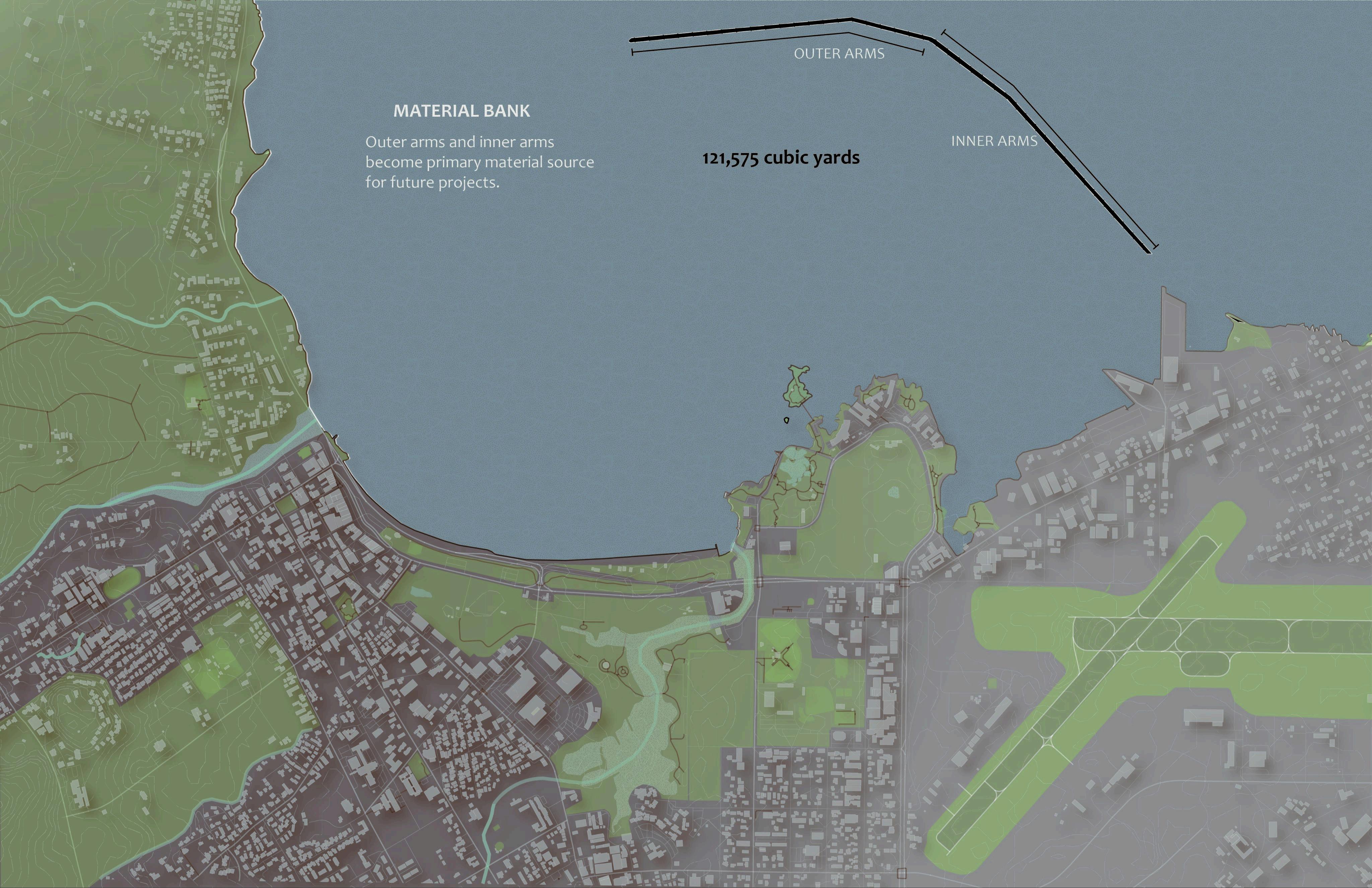
Above- Hilo Bay Breakwater sectional diagram with material, material sourcing and size analysis.
In the context of Hilo Bay, eutrophication refers to the over-enrichment of bay waters with nutrients—mainly nitrogen and phosphorus—from sources like river runoff, agricultural drainage, and urban stormwater. This nutrient loading, especially after heavy rain events via the Wailuku and Wailoa Rivers, fuels excessive growth of algae and phytoplankton. The result is often algal blooms, which reduce water clarity and, when they die off, lead to oxygen depletion as bacteria decompose the biomass. This process can cause hypoxia (low oxygen levels), stressing or killing fish and invertebrates, and degrading water quality further. Hilo Bay’s restricted water circulation, partly due to the breakwater, worsens this problem by trapping nutrients and slowing flushing.
The halocline in Hilo Bay—where fresher river water overlays denser, saltier ocean water—forms a sharp salinity gradient, especially near the river mouths. During heavy rainfall, a pronounced halocline can develop as massive freshwater input sits atop the more saline bay water. This vertical stratification further limits mixing and oxygenation of the deeper layers, compounding eutrophication effects by allowing bottom waters to become stagnant and anoxic. Together, eutrophication and halocline stratification create a feedback loop that impairs ecosystem health and reduces habitat quality for benthic species.
DEEP BREATHS FOR HILO BAY
Above - Sediment engulfing coral - photo by Miami Waterkeeper
Below - Perspective of fish and invertebrates living on and around the breakwater.
Above- Section of tidal change along the wall with specific inter tidal zones identified.
Species Analysis
Fish
Hilo’s marine fauna include both reef and inshore fishes, but habitat limitations constrain local fisheries. Hilo Bay itself has very little live coral or reef; one 1978 survey found that 36.2% of Hawai i’s recreational anglers fished in Hilo Bay, but catch rates there were low and only good around the handful of rocky structures (breakwater and revetment) that have live coral [7]. In effect, most fishing success in Hilo comes from the scarce hard-bottom areas near the harbor wall. Common reef species in the region include surgeonfishes, parrotfishes, goatfishes and snappers (as seen in island-wide reef surveys), while pelagic schooling fish ( ōpelu Decapterus macarellus, akule Trachurus symmetricus, etc.) also enter the bay. However, the heavy silt and limited reef means Hilo’s fish biomass is lower than in clearer-water areas. In summary, Hilo supports a typical Hawaiian reef fish community, but with depressed abundance and diversity due to turbidity and habitat loss.
Invertebrates
Benthic invertebrates in Hilo include reef-building corals, sea urchins, mollusks, and crustaceans, but many are limited by habitat quality. In Hilo Bay the bottom is mostly soft mud, so reef organisms are found only on the few hard substrates near shore. Surveys noted that anchialine pools (brackish volcanic ponds) near Hilo host unique shrimp and crab species, yet these rare habitats have been “disturbed significantly by filling, septic tank seepage, and introduced predators” in developed areas [7]. Similarly, the scarce coral patches (Porites, Montipora, etc.) near the harbor have suffered from sedimentation and bleaching. Essentially, to sustain invertebrates like corals and shrimp, Hilo needs clean hard substrate: where rock or consolidated reef is present, invertebrate communities persist, but where mud or fine sediment dominates, they cannot. Thus invertebrate abundance in Hilo is patchy and tied to the preservation of coarse substrate areas.
Vegetation
Hilo lies in an extremely wet tropical forest zone (≈3.6 m of rain per year [1]). Native lowland and montane rainforests dominate the surrounding landscape, with canopy trees such as ōhi a lehua (Metrosideros polymorpha) and koa (Acacia koa) supporting rich understories. These forests are multilayered – for example, a typical wet forest in the Hilo Forest Reserve has two overstory layers (~5–30 m tall), a mid-story of tree ferns (~3–5 m), and a fern-dominated understory (~0.5–2 m) [2]. Such wet-forest communities are globally unique but also very fragile: about 75% of Hawai i’s native plant communities are considered endangered by development and invasive species [3]. In Hilo the heavy rainfall sustains lush vegetation, yet urban expansion and agriculture have replaced much of the original forest at low elevations. Conservation efforts (e.g. replanting koa and ōhi a in the Hilo Forest Reserve) aim to rebuild these native forests and their biodiversity.
DEEP BREATHS FOR HILO BAY
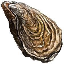
Left- Illustration of Pacific Oyster' Crassostrea gigas.
DEEP BREATHS FOR HILO BAY
Above- Plan analysis of community fishing zones with counts of witnessed interaction.
DEEP BREATHS FOR HILO BAY
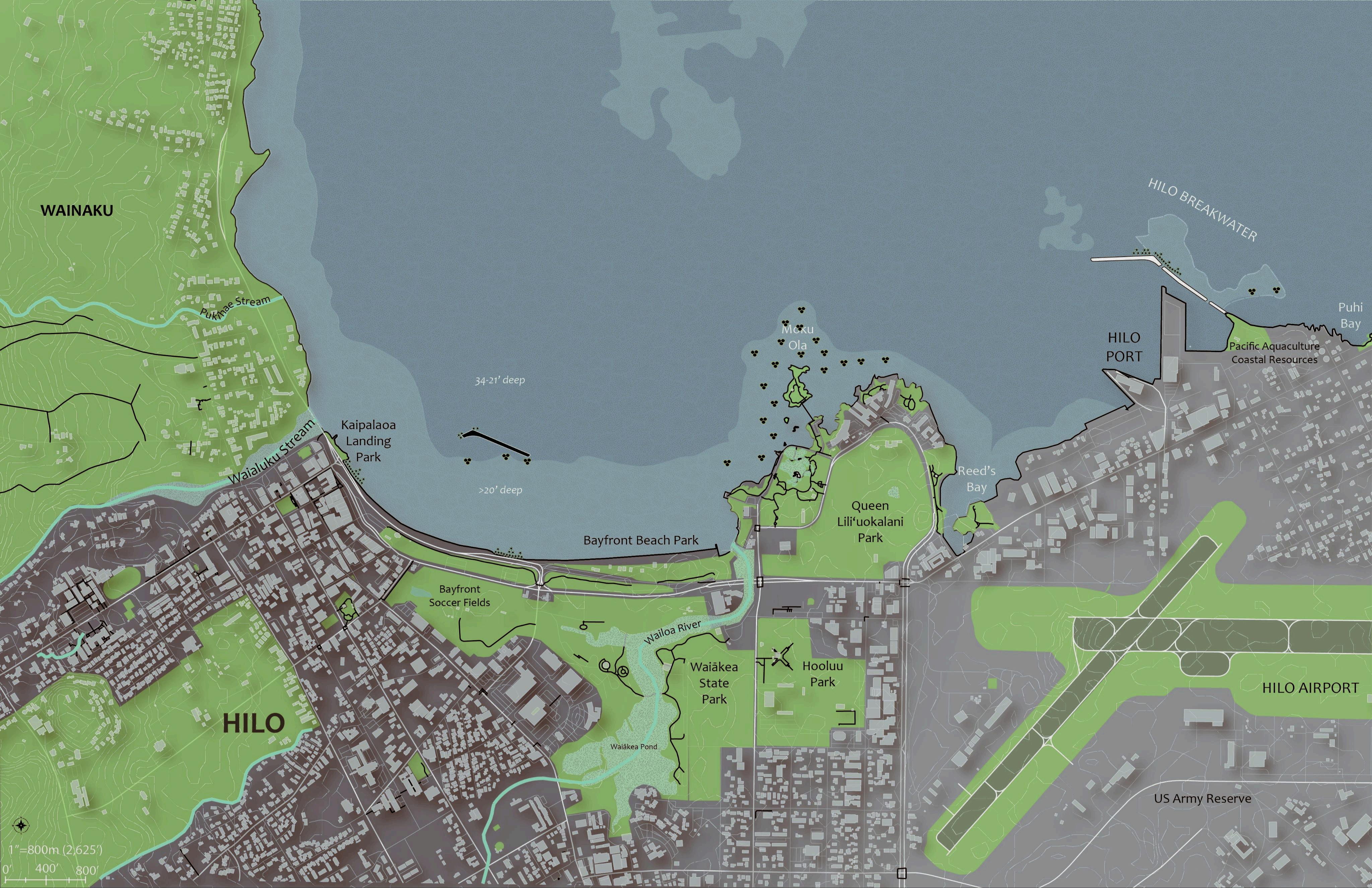
Above- Existing Site Plan with Context
DESIGN
Above - Showing wind and wave directions as they hit Hilo prior to the installation of the breakwater and the changes that followed its construction.
Left - Plan showing the bay's internal gyers formed by the breakwaters influence on sediment and water flow.
Above - Showing wind and wave directions as they hit Hilo prior to the installation of the breakwater and the changes that followed its construction.
Left - Plan showing the bay's internal gyers formed by the breakwaters influence on sediment and water flow.
DEEP BREATHS FOR HILO BAY
Above - The proposed site plan for the reorientation of the wall and the module placements.
DEEP BREATHS FOR HILO BAY
Above - The proposed site plan for the reorientation of the wall and the module placements.
Basalt as a Material
Basalt, a dense igneous rock composed primarily of plagioclase feldspar, pyroxene, and olivine, offers a range of properties that make it both a strong breakwater material and a potential substrate for invertebrate recruitment. At the microscale, basalt is chemically stable and non-toxic, with a neutral to mildly alkaline pH that supports the development of microbial biofilms essential for larval settlement. Fresh basalt tends to have a smooth surface, which is less ideal for colonization, but weathering over time creates micro-pitting that enhances attachment. At the mesoscale, basalt exhibits high compressive strength (100–300 MPa), high density (around 2.8–3.0 g/cm³), and excellent durability against salinity,
UV exposure, and freeze-thaw cycles, although it is difficult to quarry and shape. It offers moderate wave energy dissipation and strong stability due to its weight, making it effective in storm-prone environments. Ecologically, basalt supports colonization by barnacles, mussels, oysters, and some coral species, though its low surface complexity limits habitat diversity unless engineered with additional structural features like crevices or stacked modules. One drawback in tropical settings is its high heat absorption due to its dark color, which can lead to thermal stress for intertidal organisms. While it favors hardy, fast-settling species, basalt's long-term substrate stability supports gradual reef development. To enhance its ecological value, designers can increase surface heterogeneity through roughening, fracturing, or integrating basalt with eco-concrete elements, as well as applying pre-seeded biofilm treatments.
DEEP BREATHS FOR HILO BAY
Above - The proposed site plan for the reorientation of the wall and the module placements.
Works Cited
Hawaii Coral Reef Initiative. Hilo Bay Watershed and Coral Reef Assessment. University of Hawai‘i at Mānoa, 2005.
U.S. Army Corps of Engineers. Final Environmental Impact Statement for the Hilo Harbor Improvement Project. Department of the Army, 1998.
Dollar, Stephen J., and Michael K. Tribble. Physical and Biological Characterization of the Nearshore Environment of Hilo Bay, Hawai‘i. Department of Oceanography, University of Hawai‘i, 1993.
Hawai‘i Department of Health. Integrated Report to the U.S. Environmental Protection Agency and U.S. Congress Pursuant to Clean Water Act §303(d) and §305(b). State of Hawai‘i, 2022.
https://health.hawaii.gov/cwb/clean-water-branch-home-page/integrated -report/
Hawai‘i Coastal Zone Management Program. Hawai‘i Ocean Resources Management Plan. Office of Planning, State of Hawai‘i, 2020. https://planning.hawaii.gov/czm/ormp/
Caires, Sara, and Shellie Habel. Coastal Hazard Exposure and Sea Level Rise Vulnerability of Hilo Bayfront and Downtown. University of Hawai‘i Sea Grant College Program, 2020.
Fletcher, Charles H., et al. Hawai‘i Sea Level Rise Vulnerability and Adaptation Report. Hawai‘i Climate Change Mitigation and Adaptation Commission, 2017.
Bhandari, Utsav, and Camilo Mora. “Impact of Sediment Loading on Coral Reef Health: A Global Meta-Analysis.” Marine Pollution Bulletin, vol. 150, 2020, p. 110726.
Silvius, Kirsten, Philip Moravcik, Mary James, and Hilo Bay Watershed Advisory Group (WAG). 2005. “Hilo Bay Watershed-Based Restoration Plan.” Hawaii Department of Health, Clean Water Branch. Prepared by Townscape, Inc. Accessed January 21, 2025.
https://health.hawaii.gov/cwb/files/2013/05/PRC_Maps_HiloBayWatershe d.pdf.
US Army Corps of Engineers Honolulu District and County of Hawaii Planning Department. 2009. “Hilo Bay Water Circulation and Water Quality Study.” County of Hawaii.Prepared by Sea Engineering, Inc. Accessed January 21, 2025.
https://acrobat.adobe.com/id/urn:aaid:sc:VA6C2:fa1dbb95-d374-4f5e-99c9 -908d573e8cd8
Badlowski, Gina A, Jason E Adolf, and Geoffrey Fouad. “Spatial Analysis of Water Quality Parameters in Hilo Bay, Hawai’i, Using a Combination of Interpolated Surfaces and Hot Spot Analysis.” Environmental Monitoring and Assessment 193, no. 3 (2021): 118-. doi:10.1007/s10661-021-08894-6.
US Army Corps of Engineers Honolulu District and County of Hawaii Planning Department. 2023. “Hilo Bay Watershed Planning Assistance to States.”Hawaii County. Prepared by The Nature Conservancy and Pacific Watershed Associates. Accessed January 21, 2025
https://acrobat.adobe.com/id/urn:aaid:sc:VA6C2:e29ff71a-2458-4fc2-9ddfd89099b3a1fb
Websites
https://www.usclimatedata.com/climate/hilo/hawaii/united-states/ ushi0022#google_vignette
Books
Hawaii Coastal Zone Management Program. Hawaii Coastal Hazard Mitigation Planning Project : Findings, Recommendations, and Technical Documents. Hawaii Coastal Zone Management Program, 1993.
Articles/ Journals
https://imagesofoldhawaii.com/breakwater/
https://commons.wikimedia.org/wiki/Category:Historical_images_of_ Hilo,_Hawaii
https://www.hawaiitribune-herald.com/2022/04/21/hawaii-news/ar my-study-wont-recommend-altering-hilo-breakwater/ https://www.staradvertiser.com/2024/08/15/hawaii-news/hilo-baywater-quality-will-continue-to-decline-uh-study-finds/ https://www.civilbeat.org/beat/607000-gallons-of-wastewater-relea sed-into-hilo-bay/
Scholarly Articles
https://health.hawaii.gov/cwb/files/2013/05/PRC_Maps_HiloBayWat ershed.pdf
US Army Corps of Engineers Honolulu District and County of Hawaii Planning Department. 2022. “Hilo Bay Watershed Planning Assistance to States.”Hawaii County.Prepared by The Nature Conservancy and Pacific Watershed Associates. Accessed January 21, 2025. https://acrobat.adobe.com/id/urn:aaid:sc:VA6C2:47ae8d7b-96d4-48 ed-91e6-565dc561ae54
Videos
https://www.youtube.com/watch?v=rXmQIsRVd_4&t=509s https://www.youtube.com/watch?v=9nHW8UrOuMQ