

Revitalizing Route 140
A Neighborhood and Corridor Study
July 2024


Federal Disclaimer, Title VI and Nondiscrimination Notice of Rights of Beneficiaries
The Southeastern Massachusetts Metropolitan Planning Organization (SMMPO) through the Southeastern Regional Planning and Economic Development District (SRPEDD) operates its programs, services, and activities in compliance with federal nondiscrimination laws including Title VI of the Civil Rights Act of 1964 (Title VI), the Civil Rights Restoration Act of 1987, and related statutes and regulations. Title VI prohibits discrimination in federally assisted programs and requires that no person in the United States of America shall, on the grounds of race, color, or national origin (including limited English proficiency), be excluded from participation in, be denied the benefits of, or be otherwise subjected to discrimination under any program or activity receiving federal assistance. Related federal nondiscrimination laws administrated by the Federal Highway Administration, the Federal Transit Administration, or both prohibit discrimination on the basis of age, sex, and disability. These protected categories are contemplated within SRPEDD’s Title VI Programs consistent with federal interpretation and administration. Additionally, SRPEDD provides meaningful access to its programs, services, and activities to individuals with limited English proficiency, in compliance with US Department of Transportation policy and guidance on federal Executive Order 13166.
Individuals seeking additional information or wishing to file a Title VI/Nondiscrimination complaint may contact the SRPEDD Title VI/Nondiscrimination Coordinator at the contact information here. All such complaints must be received, in writing, within 180 days of the alleged discriminatory occurrence. Assistance will be provided, upon request, to individuals unable to provide the complaint form in writing.
Southeastern Massachusetts Metropolitan Planning Organization (SMMPO)
Title VI Coordinator -SRPEDD
88 Broadway, Taunton, MA 02780
Phone: 508 824-1367 or dial 711 to use MassRelay
Email: aduarte@srpedd.org
Massachusetts Public Accommodation Law (M.G.L. c 272 §§92a, 98, 98a) and Executive Order 526 section 4 also prohibit discrimination in public accommodations based on religion, creed, class, race, color, denomination, sex, sexual orientation, nationality, disability, gender identity and expression, and veteran’s status, and SRPEDD and the SMMPO assures compliance with these laws. Public Accommodation Law concerns can be brought to SRPEDD’s Title VI /Nondiscrimination Coordinator or to file a complaint alleging a violation of the state’s Public Accommodation Law, contact the Massachusetts Commission Against Discrimination within 300 days of the alleged discriminatory conduct.
The SMMPO is equally committed to implementing federal Executive Order 12898, entitled “Federal Actions to Address Environmental Justice in Minority Populations and Low-Income Populations”
and Executive Order 13985 (2021) entitled “Advancing Racial Equity and Support for Underserved Communities Through the Federal Government.”
In this capacity, the SMMPO identifies and addresses disproportionately high and adverse human health or environmental effects of its programs, policies, and activities on low-income and minority, including BIPOC, Asian or Pacific Islander populations, as well as religious minorities, LQBTQ+ persons, Limited English Proficient (LEP) persons or those who have a disability. The SMMPO carries out this responsibility by the consistent, fair, just, and impartial treatment of all individuals, and by involving underserved individuals in the transportation process and considering their transportation needs in the development and review of the SMMPO’s transportation plans, programs and projects.
English: If this information is needed in another language, please contact the MPO Title VI Coordinator at 508-824-1367 ext. 235 or at aduarte@srpedd.org
Spanish: Si necesita esta información en otro idioma, por favor contacte al coordinador de MPO del Título VI al 508-824-1367 ext. 235 o en aduarte@srpedd.org
Portuguese: Caso estas informações sejam necessárias em outro idioma, por favor, contate o Coordenador de Título VI da MPO pelo telefone 508-824-1367, Ramal 235 ou em aduarte@ srpedd.org
Haitian Creole: Si yon moun bezwen enfòmasyon sa a nan yon lòt lang, tanpri kontakte Koòdonatè a Title VI MPO nan 508-824-1367 ext. 235.
Simplified Chinese: 如果需要其他语言的此信息,请致电 508-824-1367 分机联系 MPO Titl e VI 协调员。 235 或发送电子邮件至 aduarte@srpedd.org 。
Simplified Chinese: 如果需要其他语言的此信息,请致电 508-824-1367 分机联系 MPO Titl e VI 协调员。 235 或发送电子邮件至 aduarte@srpedd.org 。
Traditional Chinese: 如果需要其他語言的此信息,請致電 508-824-1367 分機聯繫 MPO Tit le VI 協調員。 235 或發送電子郵件至 aduarte@srpedd.org 。
Mon Khmer Cambodian (Khmer): ប្រសិនបើព័ត៌មាននេះត្រូវការជាភាសាផ្សេង សូមទាក់ទង អ្នកសម្របសម្រួល MPO Title VI តាមរយៈលេខ 508-824-1367 ext ។ 235 ឬនៅ aduarte@ srpedd.org ។
Revitalizing Route 140
A Neighborhood and Corridor Study
July 2024
All photography within this report was captured by SRPEDD, unless otherwise stated.
Maps produced by SRPEDD are for the sole purpose of aiding regional planning decisions and are not warranted for any other use. These maps are not intended for engineering, legal, or survey purposes. Data sources for the maps within this report include MassGIS, MassDOT and the City of Taunton.
Acknowledgments
CITY OF TAUNTON
Revitalizing Route 140 would not have been possible without the support, input, and local knowledge provided by the City of Taunton’s professional staff and leadership. The City would also like to acknowledge the following for their role in preparing this document:
Mayor's Office
Office of Economic and Community Development
Jay Pateakos - Director
Jim Howland - Assistant Director
Planning and Conservation Department
Kevin Scanlon, AICP - Director
SOUTHEASTERN REGIONAL PLANNING AND ECONOMIC DEVELOPMENT DISTRICT (SRPEDD)
This Report was completed with assistance from SRPEDD with funds from the Commonwealth of Massachusetts’s One Stop for Growth grant program and District Local Technical Assistance funds.
Robert Cabral - Director of Housing and Community Development
Andrea Duarte - Transportation Outreach Coordinator
Kevin Ham - Director of Homeland Security
Jackie Jones, AICP - Assistant Director of Transportation Planning
Maria Jones - Senior Public Engagement and Communications Planner
Danyel Kenis - Urban Design Planner
Grant King, AICP - Deputy Director & Comprehensive Planning Manager
Taylor Perez - Assistant Director of Housing and Community Development
Provide increased housing opportunities and highlight locations for economic development.
Prioritize placemaking to create a high-quality experience along the 140 corridor. 100
of Taunton
Shaunna O'Connell, Mayor
City
Existing Conditions
The City of Taunton is one of the Commonwealth’s 26 Gateway Cities; a place that many call home and a significant economic anchor for southeastern Massachusetts. For those entering the City from the southeast (in towns such as Berkley, Freetown, Lakeville, Acushnet and beyond), Route 140 is the "gateway" that travelers will experience.
Nearly all travelers will do so by car and they might complain about traffic (especially during times when school gets out). Those who do try to walk or bike along describe feeling unsafe at several points along the corridor. While these represent some areas for improvement, this portion of 140 is also highly imageable. Travelers will pass by the Federally designated Wild and Scenic Taunton River; many will stop at Trucchi’s to pick up groceries; and the thoroughfare connects directly to Taunton’s historic downtown.
The purpose of this study is to identify and respond to concerns of those who frequent
the corridor. Additionally, it will seek to improve safety and access for those who utilize the corridor for walking, biking, and driving. Lastly, it will seek to make a corridor that is responsive to future growth by highlighting opportunities for development, public realm and placemaking improvements, as well as considerations for preservation and enhancements of the natural ecosystems next to which the corridor coexists. By approaching the corridor holistically, this study will seek to paint a picture of a true gateway corridor for the City.
Photo 1. (Right) Drone shot of the intersection at Hart's Four Corners.


Crashes
The most recent three-year period of crash reports (2015 through 2017) were obtained from all four municipal police departments and analyzed for the study area intersections. Most of the study area intersections had crash rates below both the most recently available Statewide and District 5 average crash rates for signalized and unsignalized intersections and only a handful of locations had concerning numbers of injury crashes. That said, improvements can be made to enhance safety at a number of locations. Table 1 provides a summary of the crash data for the study area intersections.
At the time of the analysis, the Statewide & District 5 region crash rate (ACC/MEV) thresholds were 0.78 and 0.75 respectively for signalized intersections and 0.57 for unsignalized intersections. Locations with averages above statewide or regional thresholds are indicated in red – identifying a safety issue.
Photo 2. (Top) The intersection at Hart's Four Corners.
Photo 3. (Bottom) Route 140 by Trucchi's looking south.


Map 1. High crash areas along the corridor.
Signalized and Unsignalized Operations
Turning movement counts (TMCs) were conducted at 8 intersections by SRPEDD during the AM, Midday, PM, and Saturday Midday. As shown in Table 1, 4, and 5, the study area includes 6 signalized intersections. Under exiting conditions, Route 140 provides one lane of travel for thru movements at all the signalized intersections in section 2 to 3 of the study area. Section 4 which includes the intersections of Depot Drive and Mozzone Boulevard provide two lanes of travel along Route 140. The intersection at Route 44 and the intersection along Hart Street are the only intersections that provide a turning storage lane along Route 140. The intersections of Hart Street, Depot Drive and Mozzone Boulevard, which all fall under section 4, are the only intersections the provide a turning storage lane along the side streets. These three intersections are also the only locations that provide a phase for a protected left turn. A protected left turn phase provides a green arrow for left turning vehicles while stopping on-coming traffic to eliminate conflicts for those attempting a turn from Route 140 to or from a side street. The intersection at Depot Drive and Mozzone Boulevard also provide a permitted left turn in addition to the protected phase. This portion of the phase allows a vehicle to complete their turning maneuver
Table 1. Section 2 Signalized Intersections
Route 140 Intersection
Route 44
Spring Street
Phase I Phase II


only if there is a safe or acceptable gap in the opposing through traffic.
As shown in Table 2 and 3, the study area includes 2 unsignalized intersections all under stop control at the side streets. With no signal control at the intersections, all turning movements operate under a permitted condition. There are no turn storage lanes available from these side streets. The William Street intersection restricts left turn movement at the westbound approach onto Route 140 for those who want to travel north.
Table 2. Section 2 Stop Controlled Intersections
Route 140 Intersection Phase I
Ingell Street


Table 4. Section 3 Signalized Intersections
Table 3. Section 3 Signalized Intersections
Route 140 Intersection Phase I Phase II
Includes Ingell Street Intersection from Section 2
William Street


Riverway Drive
Table 5. Section 4 Signalized Intersections Route 140 Intersection
Hart Street Route


Includes Hart Street Intersection from Section 3 Depot Drive


Level of Service
Level-of-service (LOS) analysis is a general measure that summarizes the overall operation of an intersection or transportation facility. The analysis includes inputs such as lane uses and widths, traffic control, traffic volumes and operating speeds to calculate a range of operating conditions. It is summarized with letter grades from “A” to “F”, with “A” being the most desirable and “F” representing the maximum flow rate or the worst possible traffic congestion. Table 6 to 9 include the analysis results of the TMCs during the AM, Midday, PM peak periods, and the Saturday Midday which were determined using the Synchro software.
The results show that most of the study area’s intersections operate with an acceptable delay (LOS D or better) during the four scenario periods. The exception was during what is the heaviest peak period for a majority of the intersections, the PM peak hour, at the signalized intersections of Route 44 and at Riverway Drive where they operated at a LOS F and E. The other location that operated poorly during the PM peak hour was the unsignalized intersection of Ingell Street. The intersection of Hart Street, which experiences the most volume at the majority of the periods and previously updated its geometry and signal system, operated well at a LOS C during all the scenario periods.
Table 6. Study Area AM Peak Hour Level-of-Service (LOS) and Delay
Table 7. Study Area Midday Level-of-Service (LOS) and Delay
Table 8. Study Area PM Peak Hour Level-of-Service (LOS) and Delay
Table 9. Study Area Saturday Midday Level-of-Service (LOS) and Delay
Travel Time
The travel time is the amount of time it takes to get from one point to the next, which was calculated using the Synchro software. Table 10 shows the calculated travel time from one end of the study limits to the other in both the eastbound and westbound direction. The calculated travel time varies between intersections and is dependent on the speed traveled and the delay experienced at each intersection. Table 10 shows that the greatest overall travel time was experienced during the PM Peak. The greatest travel time in the northbound direction was experienced during the Saturday Midday at 8.5 minutes and southbound direction was experienced during the PM Peak at 11.5 minutes. As previously stated, with a majority of the delay being experienced within the PM Peak hour, it is expected that the greatest travel time would occur during PM peak period. In addition to the study areas travel time, the travel time for each section was calculated as show in Table 11 to 12. The data shows that the travel time was greatest at Section 3 for each scenario.

Photo 4. Construction work at the interchange of 140 and 24.
Table 10. Study Area Travel Time
Table 11. Section 1 Travel Time
Table 12. Section 2 Travel Time
Table 13. Section 3 Travel Time
Table 14. Section 4 Travel Time
PM Level of Service
Free Flow: low volumes and no delays
Stable Flow: speeds restricted by travel conditions, minor delays
Unstable Flow: low speeds; considerable delays; volume at or slightly over capacity Weekday Average Daily Traffic
Stable Flow: speeds and maneuverability closely controlled because of higher volumes
Forced Flow: very low speeds; volumes exceed capacity; long delays with stop-and-go traffic
Map 2.
Traffic Volume
Over the spring and fall of 2022, SRPEDD staff and MassDOT collected roadway traffic data using Automatic Traffic Recorders (ATRs) that provided volumes, speeds, and vehicle classifications for weekday and weekend travel patterns. SRPEDD collected data along the side streets while MassDOT collected the counts along Route 140 and Riverway Drive. Counts were taken during typical commuting conditions, while students are in school and not during holidays.
A total of 12 ATR counters were placed throughout the study area. Section 2 of the study area consisted of five count locations, with one along Route 140 and four along side streets. Section 3 consisted of three location, with two along Route 140 and one along a side street. Section 4 consisted of four locations, with two along Route 140
and two along the side street. There were no ATR counts completed along Section 1. The highest traffic volumes recorded along Route 140 were in the southern portion of the study area at the southern end of Section 3 and along Section 4. As expected, the higher volumes were found along Route 140 near roadways that provide access to commercial areas. The highest volume recorded was at the count location of Route 140 north of Hart Street at 33,264 vehciles per day (vpd) during the weekday and 22,853 vpd during the weekend. The volume along Route 140 decreased when traveling north towards Section 1 at the count location of Route 140 north of Prospect Street at 9,651 vpd during the weekday and 7,518 vpd during the weekend. Tables 1 to 3 show the weekday and weekend volume counts for section 2 to 4.
Speed
The data collected recorded the 85th percentile speed and average speed at each count location. The 85th percentile speed is the speed at or below which 85 percent of all vehicles are observed to travel under free‐flowing conditions past a monitored point. The Manual on Uniform Traffic Control Devices (MUTCD) states that the posted speed limit be within 5 mph (plus or minus) of the 85th percentile speed. This recorded speed is the design speed used for posting a speed limit along a roadway. A seen in in Tables 4 to 6, the 85th percentile speed was recorded at its lowest along Route 140 at the location of Route 140 south of Ingell Street at 36.2 miles per hour (mph) for northbound traveling vehciles and 34.9 mph for southbound traveling vehciles. It recorded its highest at the location of Route 140 south of Hart Street at 37.9 mph for northbound traveling vehciles and 43.3 mph for southbound traveling vehciles.
Along the side streets, the 85th percentile speed was recorded at its lowest at the location of Prospect Street East of Summer Street at 30.9 mph for eastbound traveling vehciles and at 31 mph for westbound traveling vehciles. It recorded its highest at the location of Riverway Road east of County Street at 52.8 mph for eastbound traveling vehciles and 34.7 mph for westbound traveling vehciles. This location provides direct access to Route 44 to the north and Williams Street to the east where the Taunton High School is located. Although higher speeds were expected at the more commercial developed areas where higher speed limits are posted, the data shows that locations such as Route 140 north of Prospect Street which has a lower speed limit posted, also experienced higher speeds.
Map 3. Posted
Transit
The Greater Attleboro Taunton Regional Transit Authority (GATRA) oversees fixedroute bus service and demand response service for people with disabilities and seniors in southeastern Massachusetts.
GATRA’s service area expands outside of the SRPEDD region with a total of 29 member communities, including the cities of Taunton and Attleboro. Within the designated study area, GATRA operates two fixed routes: Route 5 – Walmart/East Taunton/Target and Route 8 – County Street/Target.
ROUTE 5 – WALMART/EAST TAUNTON/ TARGET
Route 5 serves the East Taunton area between Walmart in Raynham and Target in Taunton and does not serve the Taunton Bus Terminal. Route 5 serves Taunton High School on a deviated route, meaning it travels a different route to serve the high school on specific trips only and during school days. For one morning trip and one afternoon trip, Route 5 deviates onto County Street (Route 140) to serve the high school.
ROUTE 8 – COUNTY STREET/TARGET
Route 8 serves the Weir Village area between the Taunton Bus Terminal and Target via Ingell Street and Hart Street. Like Route 5, Route 8 also serves Taunton High School on a deviate route. For one morning trip and five afternoon trips, Route 8 deviates onto County Street (Route 140) to serve the high school.
Within the study area, GATRA only operates deviated service (to the high school) between Harts Four Corners (County Street at Hart Street) and Ingell Street.
Route Name
Route
Route
Route
Route
Map 4. Bus routes along the corridor.

BUS STOPS
While there are a few posted bus stop signs along the study area, GATRA’s fixed route bus service operates on a flag system. A flag system is when a transit agency does not have designated bus stops with a posted bus stop sign. A rider is allowed to board or deboard the bus anywhere along the route where it is safe to do so. When waiting to board, a rider can be anywhere along the bus route, wave to the bus as it approaches, and the driver will stop to pick them up. Likewise, when deboarding, the rider can signal, anywhere along the bus route that they would like to deboard, and the driver will stop where it is safe to do so. An exception to this rule is the Taunton Green area. GATRA fixed route operates closed door, meaning it does not stop for boardings or deboardings, between the Taunton Police Station and the bus stop on Court Street in front of the
Bristol County Superior Court.
The main stops along the study area include the Taunton Depot plaza (Target), County Street by the various apartment buildings just north of the Taunton Depot plaza (Taunton Gardens, Country Village Estates, etc.), Harts Four Corners, and the Taunton Police Station/City Hall. Within the study area there are six physical bus stop signs located at: 1) Target 2) County Street at Karena Drive (northbound), 3) County Street at Johnson Street (southbound), 4) County Street at Linden Street (northbound), 5) County Street at Linden Street (southbound), and 6) Taunton Police Station/City Hall. With the exception of benches at the Target bus stop, there are no amenities (shelter, bench, etc.) at any of the signed bus stop locations.
Photo 5. A GATRA bus at the intersection of .
RIDERSHIP
Of the Taunton bus routes, Route 8 (along with Route 7) has the highest ridership. Route 5 on the other hand has moderate ridership, with the THS trips making up large portion of its riders. Bus ridership throughout the nation was broadly impacted as a result of the COVID-19 Pandemic. While ridership continues to recover during the recovery of the pandemic, bus ridership is trending upward. Due to the pandemic, Route 8 saw a 62% decrease in ridership from fiscal year 2020 to fiscal year 2021. Although not back to pre-pandemic numbers, ridership is on a steady incline, with Route 8 seeing a 51% increase in ridership from FY 2021 to FY 2022. Route 5 began operation in April of 2020 and has also seen a steady incline since its inception.

Photo 6. A GATRA bus at the Mansfield Station Commuter Rail stop. Source: Anonymous/Wikimedia Commons.
Map 5. Zoning and relevant overlays along the corridor.
Zoning
The route 140 study area includes a variety of zoning types. Just over one third (35%) of the study area is zoned for residential uses (32% Urban Residential, 3% Suburban Residential). Another third (33%) is zoned for industrial uses. Most of this industrial land sits in the “Future TOD” focus area, adjacent to Taunton’s future MBTA Commuter Rail Station. Additionally, roughly fifteen (15%) of the study area contains commercially zoned land. This land is roughly split – with half of the land (8% of the total study area) comprising the area surrounding Hart’s Four Corners and another half (7% of the total study area) comprising Downtown’s Central Business District. Lastly, a similar amount of land area (17% of the study area) contains
parks and open space. Much of this space includes Taunton Schools, as well as the Bristol-Plymouth Regional Technical School, as well as adjacent amenities, such as the land associated with the Theodore J. Alexio Jr. Skating Rink.
In general, the areas zoned industrial represent opportunities for the most significant opportunity to accommodate a larger variety of building types (such as housing and mixed-use development), particularly in accordance with future Section 3A MBTA Multi-family Requirements, while the Highway Business District also identifies an opportunity for development.


Land Use
Land use along Route 140 largely aligns with the area’s zoning. While the downtown maintains a mix of uses on smaller lot sizes, land use patterns shift towards residential as the corridor continues towards the Wild & Scenic Taunton River. These residential land uses give way to a series of commercial blocks around Hart’s Four Corners, which sit adjacent to multi-family (4+ units) buildings. The Future TOD district contains a mix of large-lot land uses, including industrial, commercial, and some office parcels. Significant portions of institutional land house Taunton Schools and the Bristol-Plymouth Regional Technical School along the study area.
Photo 7. (Top) Route 140 and Taunton's Downtown.
Photo 8. (Bottom) Residential uses along 140.
Map 7. Sidewalk width along the corridor.
Pedestrian Access
From downtown Taunton to the Taunton River, MA-140 (Summer Street) is lined with sidewalks on both sides, allowing for uninterrupted pedestrian foot traffic. However, moving away from the center of the City, sidewalk quality becomes less consistent.
Two sidewalk gaps on the North-facing side of the road, the first between the Linden/County Streets intersection and 459 County Street, and the second between Deer Park Village Apartments and Castle Self Storage cause the most significant interruption in pedestrian connectivity. When added together, these two gaps result in over half a mile (0.6) of missing sidewalk on one side of the road.
The placement of utility poles, either directly in, or close to the center of the walkway,
further reduces walkability, bikeability, and general accessibility, making these areas potentially inaccessible for wheelchair users. In the same vein, the slopes to access the sidewalks in many spots along the corridor are far too steep for wheelchair users and individuals with mobility challenges to comfortably and reliably scale.
The combination of these factors creates significant gaps and an overall lack of consistency as one tries to move from the TOD neighborhood to the Downtown. Due to larger-than-necessary rights of way and the potential of future developments, there exist significant opportunities to improve access and the quality of the public realm streetscape along the corridor.
Open Space
Open spaces serve as critical assets to the community and can complement economic development efforts; they can also indicate areas where the town may choose to avoid any disturbance associated with the built environment. While developers must honor parcels with permanent conservation easements, it is important to consider the interplay of open spaces and more intensive development along the Route 140 corridor. The significant open spaces in Taunton include:
TAUNTON GREEN
The Taunton Green, in many ways, embodies the spirit of the traditional “Town Square”. Historically, the Green served as a gathering place for troops during war-time. It also served as an early commercial, industrial, and public center. Even though the Green is diminished in size from its historic peak, it still serves an important role as a Town Center. Residents and visitors particularly look forward to holiday light displays every winter.
MILL RIVER PARK
Located along a bend in the Taunton River, Mill River Park plays an important environmental role connecting Taunton’s downtown to the location’s underlying natural and ecological systems. The Park serves local species - providing significant vegetation and habitat for local species. Further, the park assists with bioretention, cleaning stormwater from downtown from chemicals, metals and particulates, allowing clean water to access the Wild and Scenic Taunton River.
ALEIXO ARENA
Named after former Mayor, Theodore Aleixo Jr., this ice rink is a Commonwealth of Massachusetts public ice-skating facility, overseen by the Department of Conservation and Recreation. The Theodore Aleixo rink offers opportunities for youth sports, skating clubs, open skating hours, and other recreative uses.
PLONKA PROPERTY AT LAKE SABBITIA
The Plonka Property is open space land, protected in perpetuity, located across Dean Street from Lake Sabbatia. During public feedback, respondents identified it as a location that they would like to see developed into a more formalized space
WEIR VILLAGE RIVERFRONT PARK NORTH AND SOUTH POND
Located on the Taunton River, Weir Village Riverfront Park provides boat ramps for launching boats, canoes, and kayaks into the Taunton River. With the removal of the 85ft West Britannia Dam in 2018, the resulting beautification of the former F.B. Rogers Silver Co features a one thousand long foot walkway, raingardens along the river’s edge to support the ecofriendly absorption of stormwater runoff from nearby impervious surfaces (ae. Parking lots and streets).
FUTURE TOD DISTRICT
The TOD District is the site of the incoming MBTA Commuter Rail station. Palustrine Forested Wetlands and aquatic bed with pockets of uninhabited open land use provide the opportunity for future development of bike paths and pedestrian trails along the TOD/Route 140 Corridor.
BRISTOL PLYMOTH REGIONAL TECHNICAL SCHOOL
Bristol Plymouth Regional Tech School, located in East Taunton, is covered in impervious surface area and restricted in use by open space restrictions surrounding the area. However as part of the Taunton Space Open Plan, school facilities are a valued source of recreational opportunities for people of all ages. The accessibility of recreational programing in public schools are a top priority of the City of Taunton, and the region Route 140 serves.
Williams
Taunton
Mill River Park
Plonka Property
Taunton Schools
Aleixo Arena
Wild & ScenicT
Climate Resilience
While mostly resilient to flooding, the 140-study area contains a portion of the Wild & Scenic Taunton River; a regulatory floodway. From this, the area between along the Floodway and the area south of Downtown are subject to flood risk, ranging from 0.2 to 1% chance of flooding. In addition to traditional stormwater infrastructure, the city addressed stormwater runoff through the development of Mill River Park, which

manages stormwater volumes and cleans non-point source runoff flowing into the River from Downtown.
Building off the success of projects like Mill River Park, the study area presents an opportunity to incorporate best management practices along the route to manage stormwater volume and pollutants.

Photo 9. (Left) Mill River after removal of the West Britannia Dam in the fall of 2018. Source: Emily Myron/TNC.
Photo 10. (Right) Mill River several years after dam removal and ecological restoration. Source: Alison Bowden/TNC.
A: 1% Annual Chance of Flooding, no BFE
AE: 1% Annual Chance of Flooding, with BFE
AE: Regulatory Floodway
X: 0.2% Annual Chance of Flooding
Map 9. FEMA Floodzones and wetlands along the corridor.
Enlargement Zones
DOWNTOWN
Taunton’s Historic downtown sits at the confluence of several arterial, regional thoroughfares (Route 140, Route 138, and Route 44), each of which guides traffic to the iconic Taunton Green. Located at the Downtown’s center, the Green serves as a long-standing commercial hub that is increasingly becoming a destination for local businesses in the area. Recent placemaking strategies in the city including signage, public art, sidewalk improvements, and more, have provided key wayfinding improvements
and further established the Downtown as a pedestrian destination.
Further developing Downtown Taunton’s non-motorized transportation infrastructure, along with strategic placemaking interventions will continue to help this area serve as a destination for those looking to live, work, shop, and enjoy the Downtown’s public spaces. Further, investments in local businesses and architecture can help further emphasize Downtown’s evolving history as a commercial center for the city and the region.
CohannetStreet
Fredrick R. Martin Sr Parkway
Tremont Street Wild and Scenic Taunton River
Taunton Green
Morton Hospital


Photo 11. (Rows 1, 2, and 3) Google Street Map views within the Downtown Enlargement Zone.
Photo 12. (Bottom) Drone shot of Taunton's Downtown looking northwest.


Photo 13. (Rows 1, 2, and 3) Google Street Map views within the Wild & Scenic Taunton Enlargement Zone.
Photo 14. (Bottom) Drone shot of the Taunton River looking northwest.
City of Taunton
CountyStreet
WILD & SCENIC TAUNTON
The area surrounding the Wild & Scenic Taunton River contains low-density residential and commercial land uses, following the contour of the river. However, the surrounding area provides limited visual and recreative access to this federally designated natural system. In addition to the riverine system itself, adjacent areas include underutilized institutional land.
Considering these conditions, there exist significant opportunities to improve physical and visual connections to the river, by
leveraging either grant funding alongside the potential for modestly scaled private development to increase waterfront access through by implementing sloped walking paths down to the river, flexible open spaces at the River level, boat launches, and other similar amenities. The City could pursue signage and wayfinding to raise awareness of this location’s relationship to the water, and to highlight any future recreative opportunities.
Berkley Beer Co.
HART’S FOUR CORNERS
Hart’s Four Corners is an active commercial corridor along Route 140 that intersects its namesake, Hart Street. One of the most vehicularly trafficked along the 140 Study area, Hart’s is also the SRPEDD Region’s 39th most dangerous intersection, and as a result, received recent roadway and intersection improvements.
Building from these conditions, Hart’s Four Corners can continue to improve circulation
and congestion management, while planning to accommodate multi-modal and nonmotorized access. Additionally, the area directly around the Hart Street / Route 140 Intersection represents an opportunity for commercial development, guided by design principles, with increased connections to surrounding neighborhoods and multi-family housing.
Hart’s Four Corners
Country Village
Deer Park
The Arbors


Photo 15. (Rows 1, 2, and 3) Google Street Map views within the Hart's Four Corners Enlargement Zone.
Photo 16. (Bottom) Drone shot of Hart's Four Corners intersection looking north.


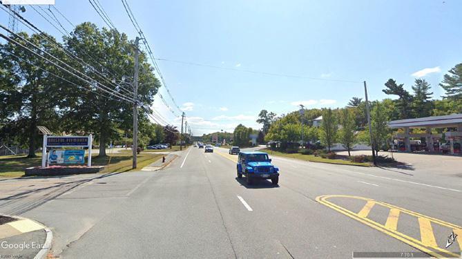


Photo 17. (Rows 1, 2, and 3) Google Street Map views within the TOD Enlargement Zone.
Photo 18. (Bottom) Drone shot of the TOD zone looking west.
FUTURE TOD
The Future TOD zoning district sits adjacent to the future MBTA Commuter Rail station to the southeast and Route 24 to the east. It primarily contains big box retail and service activity land uses and large-scale parking lots.
This location’s recent zoning changes can support a substantial increase to Taunton’s housing supply. Additionally, while the
entire district’s zoning supports ground floor commercial, the frontage along Route 140 is well suited to provide commercial and service-based ground floor uses. The scale and design of these buildings should support regional and local commuters, while providing an enhanced and pedestrian oriented public realm.
2Improvements Analysis
The 140 Corridor is undergoing change. Already located in a critical area for economic growth, this corridor will serve as the location for a new MBTA commuter rail station, enhancing the immediate area’s economic impact and the City’s regional accessibility.
The City identified its MBTA Multifamily Zoning District to the immediate northwest of Route 24, and adjacent to the new station. These changes will introduce opportunities for new housing, shopping, places to work, and more. Further, the above land use changes will necessitate new patterns of commuting along Route 140. The introduction of the MBTA Station and its adjacent development will highlight the importance of supporting shorter distance commutes, particularly trips between the downtown and the TOD district, or ‘last mile’ connections on the corridor for those traveling a short distance on the road to ride the MBTA Commuter Rail. These shorter trips create substantial opportunity to introduce pedestrian and bike infrastructure. It will be critically important to similarly introduce
safety, public realm, and quality of life improvements alongside pedestrian and bike enhancements.
Against the backdrop of this change, this study seeks to incorporate the feedback from public workshop and survey participants to identify improvements that folks would like to see. While policy and structural changes served as the catalyst to begin this study, the public process played a significant role in shaping its specific recommendations. The following section outlines recommendations, based on community feedback, to produce a series of actionable and achievable deliverables that addresses community feedback by incorporating sound planning techniques.

Many of the individuals who participated in the public feedback process live or work along the corridor, spend significant amounts of time on the roadway, or wish they were able to utilize the road more, but find it unsafe or inconvenient. These participants identified a lack of bicycle and pedestrian infrastructure along the corridor, dangerous street crossing conditions, difficulty navigating peak traffic times, and safety / traffic issues at key intersections as areas for improvement. Investing in the safety of all users will require solutions that recognize a variety of transportation modes (bike, car, pedestrian), commute distances, and reasons / requirements for utilizing Route 140. This section explores physical improvements that will facilitate these changes.
Strategy 1: Introduce a raised, separated, shared use path that runs between the future Commuter Rail Station and the Downtown.
One of the most consistent and direct themes of feedback from the public engagement process was a desire for increased bicycle access and safety. Workshop participants highlighted the ways in which a lack of existing bike infrastructure deters cyclists from utilizing Route 140 and represents significant safety concern for the cyclists’ who currently utilize this route.
Fortunately, like many streets throughout the Commonwealth and the Nation, the existing roadway and sidewalk configuration provides adequate room to accommodate a two-lane, raised shared use path with a buffer between vehicular and cycle traffic for nearly the entire stretch of Route 140
between Route 24 and Taunton’s downtown. This is largely achievable without altering the curb (I.e. without expanding the amount of paved surface). However, the City may wish to explore areas to utilize the entirety of the Right of Way in areas where it does not affect existing residences or businesses.
By bridging the Downtown and TOD districts via a separated bikepath, the city can take significant steps towards addressing commuter concerns and providing some necessary, non-motorized connections between Taunton’s downtown and its Commuter Rail station.
Moderate grade change between typical building FFE and road +/- 1’-0” curb height
Commercial + residential adjacent land-use
Concrete / asphalt sidewalks with granite curbs
Commercial + residential adjacent land-use
Concrete / asphalt sidewalks with granite curbs
Limited canopy with varied tree maturity
Utility poles obstruct path of travel
Asphalt sidewalk with granite curb

2
STREET SECTION 2: 140/INGELL ST
The section of Route 140 in the vicinity of Ingell Street currently has two wide lanes of travel, a 5 foot 2 inch sidewalk on one side and a 5 foot 8 inch sidewalk on the other. Reallocating pavement with on the intersection to allow for a more standardized travel lane width of 10 feet and creating equal sidewalk widths of 5 feet on both sides allows for a 10 foot cycle track on one side separated from traffic. This configuration would better serve all users while improving the character of the road and provide traffic calming benefits.
The intersection of Route 140 and Ingell Street is a t shaped intersection with a wide layout. Located on a wide curve which includes a bridge over the Taunton
River, users at the intersection experience difficulty with sight distance. The Ingell Street leg of the intersection features two “slip” lanes, or lanes separated from the main intersection by concrete islands which allow for vehicles turning onto and off of Ingell Street to flow into and out of the intersection without making a complete stop. This configuration encourages high rates of speeds, creates multiple conflict points, and endangers pedestrians. Removing the slip lanes and directing traffic to the stop sign would increase safety for all users with minimal impact to traffic flow. Changing the configuration would also allow for increased green space on both sides of the intersection.
Photo 19. (Top) The intersection of Route 140 and Ingell St. looking northeast.


SECTION 3: 140/CARRIAGE LN
The section of Route 140 in the vicinity of Carriage Lane currently has a wide layout that encourages vehicular speed and discourages pedestrian and bicycle transportation. Narrowing the travel lanes from 17 feet to a more standard 10 feet would allow for a reallocation of space for standard width sidewalks and a 10.5 foot separated path buffered from traffic with a 3-foot grass strip. This approach would calm traffic and improve safety for all users by providing separation for vulnerable road users and encourage lower travel speeds.
Photo 20. (Top) A cycle track in Oklahoma City. Source:
Photo 21. (Bottom) A cycle track along the Indianapolis Cultural Trail. Source:
Commercial + residential adjacent land-use
Limited canopy with varied tree maturity
Concrete / asphalt sidewalks with granite curbs
Utility poles obstruct path of travel
Asphalt sidewalk with granite curb
Utility poles obstruct path of travel
Asphalt sidewalk with granite curb
Limited canopy
Concrete / asphalt sidewalks with granite curbs
BEFORE AFTER
SECTION 4: 140/WILLIAMS ST
Route 140 near Williams Street and Gordon Owen Riverway is oversized, with wide and not well defined travel lanes. Reducing the current width to a more standard 10 foot width would allow for two five foot sidewalks and a cycle track separated from traffic with a two foot buffer.
Photo 22. (Right) Drone shot of Route 140 looking west.


SECTION 5: TRUCCHI'S
The section of Route 140 in the vicinity of Trucchi’s has wide travel lanes that encourage high rates of travel speed and discourage travel by vulnerable road users. Reducing the current 15 foot 4 inch lane widths to a standard 10 feet would allow for infrastructure that would protect and encourage travel for all users.
Photo 23. Drone shot of Trucchi's Supermarket looking east.
BEFORE AFTER
Utility poles obstruct path of travel
Limited canopy
Concrete / asphalt sidewalks with granite curbs
Forested canopy between properties
Asphalt
Utility poles obstruct path of travel
SECTION 6: TOD
This section of Route 140 is currently oriented to high speed volume and use by larger vehicles and doesn’t fit the character needed to support the current and proposed residential uses of the TOD. Reducing lane
Lane
BEFORE
Limited canopy
Concrete / asphalt sidewalks with granite curbs
widths while still accommodating the needs of larger vehicles would provide traffic calming as well as provide for infrastructure that improves the safety for all users.
Forested canopy between properties
Lane
Asphalt sidewalk with granite curb
AFTER
Traffic Lane


Photo 24. (Top) Rendering of a crosswalk along the Indianapolis Cultural Trail. Source: Indianapolis Cultural Trail.
Photo 25. (Bottom) Before and after the installation of a midblock crosswalk on Crotona Ave., NYC. Source: NYCDOT.
City of Taunton
Strategy 2: Enhance existing crosswalks and provide additional midblock crosswalks at key areas throughout the corridor.
Feedback during the public workshops strongly emphasized the importance of enhancing the current crosswalk offerings on Route 140. This can take the form of enhancing current crosswalks and providing new, additional crosswalks.
CROSSWALK ENHANCEMENTS
Workshop participants who frequently walked along Route 140 indicated they felt that crosswalk treatments could be more robust. Typical ways to enhance crosswalks include providing solid colors at crosswalks, safety islands at the midpoint of roads (when applicable), widening crosswalks, using striping to ensure that traffic is appropriately set back from the point of pedestrian crossing, and – in areas where vulnerable
populations frequently need to cross the street – elevating crosswalks to slow traffic and provide an extra layer of safety.
MIDBLOCK CROSSWALKS
Most opportunities to provide new street crossings would take the form of midblock crosswalks. These can take place between highly trafficked locations, such as commercial centers, parks, schools, or other areas where pedestrians may have a desire to cross, but do not have the opportunity to do so. While this study makes some recommendations for midblock crossing locations, the City should continue to study current and expected traffic volumes for the potential placement of midblock crossings.
Strategy 3: Right-size roads and introduce traffic calming measures to align road widths with safe speed limits.
The majority of Route 140 features wide open travel lanes that encourage high rates of vehicle speed and discourage vulnerable road users. Right-sizing the road by reducing the width of the travel lanes improves safety for all users by providing traffic calming and allowing currently underutilized space to be reallocated for improved sidewalks and separated bicycle facilities. This also allows for beautification of the roadway by providing space for street furniture, street trees, and other visual improvements.
This strategy complements G1S1 "Introduce a raised, separated, shared use path that runs between the future Commuter Rail Station and the Downtown." In assistance of the the shared use path, the widest areas of the corridor would be best served by additional pedestrian infrastructure, including plantings, widened sidewalks, and amenities to enhance the public realm.
Photo 26. Drone shot of Route 140 by Trucchi's Supermarket looking northwest.

Strategy 4:
Reconcile dangerous or inefficient turns to improve vehicular, cyclist, and pedestrian safety.
TOD AREA
The intersection of Route 140 and the Bristol Plymouth Vocational High School Driveway is a safety issue with traffic entering and exiting the driveway at the times surrounding the beginning and end of the school day. The location of the driveway has poor sight distance and there is no protection or signalization directing traffic in and out of the driveway. There are no sidewalks, crosswalks or bicycle facilities to protect and/encourage vulnerable road users traveling to school. The MassDOT District 5 office, located next to the current driveway, also has issues with entering and exiting their driveway. The District office has initiated a project to relocate their driveway and the school’s driveway to align with Mozzone Blvd. This would allow for protected turning movements and reduce the number of access points along Route 140. The new driveway access will also provide pedestrian and bicycle facilities.
In addition to crashes related to the school driveway, the majority of crashes in this area
analyzed as part of this study were related to curb cuts/access driveways along the corridor. Providing a median barrier along this section of roadway would limit turns to signalized intersections and prevent these types of crashes. Access to businesses could be provided through better internal circulation from the plazas with signalized access.
WILD & SCENIC (INGELL ST)
The intersection of Route 140 and Ingell Street is a t shaped intersection with a wide layout. Located on a wide curve which includes a bridge over the Taunton River, users at the intersection experience difficulty with sight distance. The Ingell Street leg of the intersection features two “slip” lanes, or lanes separated from the main intersection by concrete islands which allow for vehicles turning onto and off of Ingell Street to flow into and out of the intersection without making a complete stop. This configuration encourages high rates
of speeds, creates multiple conflict points, and endangers pedestrians. Removing the slip lanes and directing traffic to the stop sign would increase safety for all users with minimal impact to traffic flow. Changing the configuration would also allow for increased green space on both sides of the intersection.
DIVERTING LEFT TURNS FROM WILLIAMS STREET TO GORDON OWEN RIVERWAY
Route 140 Williams Street in Taunton intersects Route 140 at an angle on a curve. Sight distance at this location is poor due to the curve, and public feedback indicates that vehicles turning in and out of the roadway at peak travel times causes delay and safety concerns. The nearby intersection of Route 140 and Gordon Owen Riverway provides access to the same roads with the protection of a signalized intersection. A right-in, right-out configuration at this intersection reinforced with a physical barrier such as a concrete island with defined travel paths would prevent delay and improve safety by reducing conflict points at this location. It would also redirect traffic from a residential street to a more appropriate connector at Gordon Owen Riverway.

The intersection of Gordon Owen Riverway and Williams Street provides an important connection between Route 140 and Route 44, as well as access to Taunton’s High and Middle Schools, National Guard Barracks, residential neighborhoods and commercial land use. When school is in session, there is delay at the intersection for vehicles traveling southbound on Route 140 attempting to take a left onto the Riverway. A left turn lane with protection provided in signal phasing is recommended to reduce the delay during peak hours and to accommodate potential additional turning volumes from Williams Street.
Photo 27. The intersection of Ingell St. and 140.
Strategy 5: Reduce the number and size of curb cuts along Route 140.
Route 140 is home to several businesses: many of which have frequent retail visitors and others that require truck and large vehicle access. These requirements necessitate access points (or curb cuts) for parking lot circulation and, at times, require large turning radii to accommodate commercial vehicular traffic. While acknowledging that certain dimensional standards are necessary to accommodate these uses, the City should encourage the elimination and consolidation of curb cuts, whenever possible, for properties that maintain multiple access points to the same lot.
Further, the City should prioritize closing access points that are close to roadway intersections, as they introduce ambiguity for turning motions and increase the potential for vehicular collisions. A higher volume of curb cuts also increases the amount of turning movements for vehicles and can slow down traffic or create the conditions for a collision. For bikers and pedestrians, each curb cut represents a potential point of conflict, which
cannot be avoided along a journey on a sidewalk or shared use path – eliminating a curb cut or, at the least, tightening a turning radius represents a significant step forward for vehicular, pedestrian, and cyclist safety.
This strategy works in tandem with Goal 2, Strategy 5’s recommendation to bring buildings towards the street, while locating parking in the rear. In conjunction with this recommendation, future developments along the corridor can utilize shared parking lots at the back of buildings to reduce the number of curb cuts / access points to these rear parking lots, relocating these curb cuts to side streets when appropriate. Additionally, by sharing trucking access points, developments can propose a hierarchy to vehicular entrances, where curb cut radii are appropriately sized for the vehicles that are intended to use them.
While curb cuts may seem like a small detail, they can have a large impact on traffic safety, as well as the overall pedestrian experience.
Map 11. Curb cuts along the corridor.
Curb Cuts
TOD PHASING DIAGRAMS
The diagram below shows a phasing plan that utilizes the existing network of parking lots and service roads as the basis for a new walkable street network.
EXISTING
PHASE I
PHASE II
PHASE III
Strategy 6:
Introduce secondary road network to capture local traffic and provide a safer, low speed network for the TOD neighborhood.
Currently, the TOD district contains a large amount of low-density, large-footprint, bigbox shopping. A large amount of underutilized parking surrounds these buildings. Future TOD development provides a critical opportunity for City to encourage higherdensity and smaller-scale development.
One of the most proactive ways to encourage this would be to utilize the existing network of parking lots and service roads to develop a secondary network of roadways that encourages shorter vehicular trips, while also providing a safe short-distance transportation network for biking and walkability. Enabling pedestrian scale development will also encourage streetside activity and an active public realm. Further, developing this street network will help decrease traffic burden on the Route 140 corridor by providing increased connections to residences, businesses, and the MBTA commuter rail station.
Much of the development potential from the TOD neighborhood will not occur immediately. Because we know the capacity enabled by the City’s zoning change for the TOD district, it provides the opportunity to proactively
plan for a secondary road network to support future development and shape its future. In order to achieve this, the City should prioritize utilizing this roadway structure to anticipate future development. Doing so will provide a framework for the future development of parcels to ensure that it occurs in manner that supports development in the form of a neighborhood. Additionally, the City can work with land owners and developers to facilitate the phasing of this area’s transition in a way that lines up with the development and construction logistics of developing a robust secondary transportation network to ensure a healthy development for this new area.
While it will likely be a very difficult undertaking, with many stakeholders and moving parts, developing an adequate roadway network around the future TOD district will help transform this district in a way that will realize its potential to expand its commercial activity, while providing high quality places to live, and active connection to the MBTA Commuter Rail Station.
Goal 2
Provide increased housing opportunities and highlight locations for economic development.
Route 140 can help Taunton meet many of its City-wide goals, including the provision of housing; a location to build and expand its thriving local business community; and a destination that links the Downtown to its Commuter Rail Station. This change; however, does not need to occur overnight. With careful and sound planning and the proper investment, focusing development in key neighborhood centers can catalyze further development along the corridor around these centers, while protecting existing residences and highlighting the aspects that folks already love about Taunton and Route 140.
Strategy 1: Identify areas along the corridor that are ripe for development and pursue collaborative initiatives.
This strategy looks at which parcels are the most likely to change in the near future, and what types of change one might expect to occur on those parcels. The most developable parcels have specific traits in common. These parcels:
- Are commercial, industrial, or unbuilt parcels. This study’s methodology excludes any residential land or open space from consideration for development.
- Contain older buildings and are in more desirable locations. In development terms, if the built value (value of the structure) is very low compared to the land value (value of the location). Because of this, it is generally true that this site would be economically feasible to support a more intensive use.
- Do not utilize the entire lot. Developmentfriendly parcels contain a significant amount of underutilized land. Typically, this reduces the impact of redevelopment, provide space for construction staging, and makes demolition less invasive/expensive. It also provides the opportunity for a developer to profit from building out the underutilized (typically surface parking) portions of the site.
- Do not have environmental constraints, such as wetlands or other similar features that may prohibit development.


Photo 28. (Top) 10 Farnsworth by CBT Architects. Source: Chuck Choi.
Photo 29. (Bottom) Washington University in St. Louis. Source: William Rawn Associates/Tom Paule Photography.
Map 12 . Development Scenarios along 140
The map on this page shows the location of those parcels that may be the most developable and some potential development scenarios for each. These scenarios are described here and in more detail on the following page.
Low: Light retail, dining, seasonal programming for food trucks, etc.
High: 25-35 units of Low Impact Development housing.
Low: No change on either parcel.
High: 15 units of Low Impact Development housing on each parcel.
Low: parcel.
High: of residential with 35,000 retail. forward with
the
Additional Commercial to encourage property
Parks and Open Space Development Parcels
Water
Williams Street
No change on either parcel.
Combined +/- 140 units residential development 35,000 additional sqft of retail. Grocery store moves forward to front the street parking behind and off street.
Additional Recommendation: Commercial design guidelines encourage commercial property to front the street.
Design guidelines to encourage commercial property to front the street.
Consider increasing density at Hart Street intersection to encourage mixed-use development.
Low: No change.
High: 65 units of residential development.
Development Scenario:
Mixed-use district with retail, dining, and residential with up to 4,500 unit capacity and 30,000 sqft of ground floor commercial as a result of re-zoning.
Possible Timeline for Development:
+/- 500 units by 2030 +/- 1,000 units by 2040 +/- 1,750 units by 2050
Recommendation: Design guidelines for TOD District for scale, architectural styling, streets, and public/open space.
TauntonDepotDrive Depot Drive
County Street
Industrial Drive
Hart Street
Mozzone Boulevard
Parcels near the Wild and Scenic: Smaller office buildings and businesses could make way for light commercial, which builds from the successful, nearby Berkley Brewing, and / or low impact residential construction that is sensitive to the nearby riverine ecosystem.
Trucchi’s and Adjacent Parcel: Trucchi’s is a beloved grocery store along the corridor. This development scenario recommends retaining Trucchi’s as a use on the parcel in the form of a “21st century Trucchis," by moving the building towards the street, providing adjacent commercial space, and including residential above with all parking relocated to the rear of the parcel.
Parcel near Hart’s Four Corners: This undeveloped parcel could support drive access from 140, or possibly Hart Street, and serve as a location for new residential construction.
The TOD District: To comply with Section 3A’s Multifamily Zoning requirements, the City modified its TOD district and located it near its future Commuter Rail Station. While these parcels are currently big box retail, over the next several years the real estate market will likely support development of denser, primarily residential buildings, with some commercial uses. Overall, the development of this district creates the capacity for 4,500 new residential units. However, many of these properties will not immediately (or may never) be developed; some may be developed as commercial; and some may be developed below the density threshold. While it is impossible to predict the development rate of this area, it would be reasonable to expect 500 to 700 new units to develop, each decade, for the next 30-40 years.
Many of the other strategies in this section provide suggestions about the scale, form, and use of development that should occur along Route 140. The development in those strategies; however, may occur very far into the future. As a complement to those strategies, the purpose of this strategy is to provide an assessment of where and how this change may begin.

Photo 30. Frost Terrace affordable housing development in Cambridge, MA. Source: Bruner/Cott & Associates/ Robert Benson Photography.
Strategy 2: Support recently adopted zoning changes to comply with the Section 3A’s Multifamily
Zoning Requirements.
In January of 2021, the Commonwealth passed the MBTA Multifamily Zoning Act, which stipulated requirements for communities who host or are adjacent to public transportation to provide housing, with certain requirements, in the form of a multifamily zoning district. Taunton already had a TOD district that met the spirit and purpose of the Zoning Act’s requirements. However, this district required small modifications to meet density and dimensional requirements stipulated in the Multifamily Zoning Act and a relocation of the district to be closer to the Phase I Commuter Rail site.
The City voted through changes to pursue compliance with the Multifamily Zoning Act’s requirements in November of 2022. While these changes are already represented in the City’s zoning by-law, it will take many years for their realization on the ground in the form of development (see Goal 1, Strategy 1). It will be critically important for the City to work with developers and be proactive to play a hand in shaping this development to enhance the quality of life along the corridor (Goal 2, Strategy 3).
Photo 31. Drone shot of Route 140 looking east towards the 24 interchange.


Photo 32. (Top right) A historical renovation in Jersey City by Architects Fogarty Finger. Source: Alexander Severin.
Photo 33. (Top left) A neighborhood in Cincinnati. Source: Johnny Sanphilippo/Strongtowns.
Photo 34. (Bottom left) Wicker Park Historical District. Source: Wikimedia Commons.
Photo 35. (Bottom right) 336-344 Main Street in Fitchburg, MA. Source: Kurt Thompson / RE/MAX Liberty.
Strategy 3: Develop the recently adopted TOD district into a vibrant neighborhood with a variety of housing options.
Taunton’s transit-oriented development (TOD) district is located adjacent to its phase-1 MBTA station, near the intersection of Route 140 and Route 24. The primary aim of this district is to increase supply of housing in Taunton by providing a diversity of housing types for those who already live or wish to live in the City. Increasing the density close to Taunton’s transit hub, will allow the TOD district to connect residents to placesof employment via regional hubs; provide
increased walkability, bikeability, and other non-motorized connections to Downtown via the transportation recommendations in this study; and provide access to the City’s myriad amenities, open spaces, and natural resources. To achieve this, successful TOD’s often strive towards implementing this development at a higher density, with a scale that supports a pedestrian-oriented design to encourage neighborhood-like growth.
Pedestrian and bike oriented corridors
The current overlay zoning appropriately encourages this scale and style of development, while also substantially increasing the City of Taunton’s capacity for housing. However, it will be important to ensure that individual projects ultimately support the TOD district’s overarching goal to provide increased housing capacity at a pedestrian scale, which is also connected to a range of transportation options. Additionally, it will be important for developers to generate architecture that enhances the public realm, actively engages the streetscape, and provides appropriate open spaces (also see Goal 1, Strategy 6). Making sure to address this variety of needs during the development process will help continue to create great places to live in the city.
Commercial, service oriented, or mixed-use properties that front Route 140
Figure 1 . Potential Future for the TOD Zone .
Pedestrian Scale, neighborhood oriented residential development
Integrated open space and walking/biking trails
Reduce parking requirements and allow multiple buildings on big box store lots.
Strategy 4: Continue to attract high quality businesses along the corridor building upon the City’s façade and signage improvements program in the Downtown.
While improvements to the façade of a building or storefront may seem like a small place to start, the impacts of this small change can be significant. These repairs often include the removal and replacement of nonhistoric materials and the implementation of features that call attention to the building’s history or its commercial activity. This thinking led Taunton’s Mayor, alongside the Office of Economic and Community Development to utilize American Rescue Plan Act (ARPA) funding to assist downtown businesses.
Due to the success of the ongoing program, the City could extend this initiative into a permanent program. A more permanent
façade improvement program could leverage grant funds, community and financial institution partnerships, and other local anchor institutions to provide funding for small businesses who aspire to improve the physical condition of their storefront. These funds can take the form of 0% interest loans, matching funds for owners who invest in improvements, and technical assistance with navigating the design and construction process. Funding, loans, and other financial assistance typically cover design services for a business to interface with an architect and / or graphic designer, as well as the costs of construction.


Photo 36. (Top left) Murals in New Bedford, MA. Source: New Bedford Guide/Mike Silva.
Photo 37. (Top right) UC Berkely Turner Center by David Baker Architects. Source: Bruce Damonte.
Photo 38. (Bottom) Art by Lily Xie and Crystal Bi. Source: Boston Chinatown Neighborhood Center.


Taunton has seen such great success with its façade improvement program. This work has set the stage for the City to build on its momentum in the form of an ongoing program.


Photo 39. (Top and bottom left) Key to Beauty before and after façade improvements. Source: City of Taunton, Taunton Daily Gazette.
Photo 40. (Top and bottom right) Home for Our Troops before and after façade improvements. Source: City of Taunton, Taunton Daily Gazette.


Photo 41. (Top left and right) People Incorporated after façade improvements. Source: City of Taunton, Taunton Daily Gazette.
Photo 42. (Bottom left and right) Islands Café & Bakery before and after façade improvements. Source: City of Taunton, Taunton Daily Gazette.
Strategy 5: Incorporate design principles for future development along key areas along Route 140 while also protecting existing residential areas.
The scale, location, and arrangement of buildings has a significant impact on the feeling of a place and its ability to attract visitors or potential residents. While streets that have a width of 80’ or more start to become very difficult to introduce an inviting atmosphere and provide sense of safety, Route 140 has a more manageable street and sidewalk width, ranging from roughly 60’ at its widest to 30’ at its narrowest. Strategies to activate specific areas along the corridor will vary – there are; however, more universal design principles that, when utilized, go a long way towards activating the public realm, increasing the economic viability of a location, and creating welcoming places to live:
Allow buildings to front the street: Currently, much of the parking sits between building entrances and the street. By introducing street-facing buildings, the ground floors of buildings become attractive retail and dining spaces, the public realm becomes an inviting place to spend time, and visitors can access buildings more easily as pedestrians or by bike. Allowing the buildings to front the street will define the street as a welcoming place for those who wish to spend time on the corridor as a destination.
Locate parking behind buildings: When buildings front the street, parking often relocates behind the buildings (often it is relegated to parking garages, above or below ground). This creates a sense of organization around parking spaces, reduces dangerous interactions between moving vehicles and pedestrians, provides clear and legible access to storefronts, and does not hinder vehicular access to establishments.
Higher density, 3-4 story structures at key areas: Adding floors above commercial establishments creates an avenue to produce necessary housing along the corridor, provides dedicated customer base to support ground floor retail, and produces a necessary density of activity to support commercial and residential hubs along the corridor. There are some key areas where increasing the height of buildings along the street would provide the most benefit (see Strategy 6).
Protect residences with step-downs and setbacks where necessary: However, when taller buildings interface with adjacent neighborhoods, it will be important to set up design rules and guidelines for how these taller buildings interact with existing housing stock. A taller building can create undesirable shade over adjacent properties, so it will be important to introduce step-downs, where buildings reduce their height when next to less intensive uses and maintain necessary setbacks, or distances from the property line (and as a result between buildings).
While these concepts represent general rules and guidelines, following them will serve as a strong basis for establishing a successful corridor along Route 140.
Strategy 6: Encourage development around neighborhood "centers."
The Route 140 corridor crosses several land use types (provide link to existing conditions section), ranging from housing to industrial to commercial developments. While certain areas with existing housing should not be altered, some locations, particularly closer to Downtown, have significant potential for development. Much of the Route’s existing commercial development is lower density, substantially set back from the streetscape, heavily obscured by surface parking lots at the front of the property, and the buildings do not accommodate a wide range of business types or a mix of uses.
Parks and Open Space
Flood zones
Industrial District
Business District
Water Road Study Area
Harts Four Corners
Figure 2 . Potential Future for Hart's Four Corners .
Encourage buildings to front
Neighborhood center locations are those that have a high development potential and could be a target, alongside public investment, as higher intensity locations where the City could pursue the implementation of urban design principles, such as encouragement of mixed-use development, buildings that face the street, and a robust public realm. Implementing these strategies would help to kick-start this type of development in more areas along the corridor and create a series of ‘destinations.’ These destinations create a hierarchy which punctuates the continuous feeling of travel along the route, providing opportunities for shopping and dining, as well as places to live. Over time, the success of these neighborhood centers could serve as a catalyst to encourage high quality infill development.
Some examples of strong locations would be:
Hart’s Four Corners: Introduce buildings and pedestrian amenities that make the block a neighborhood hub.
Trucchi’s: Build from the success of this iconic grocery store by providing additional commercial development, including a “21st century” Trucchis that is fronting the street and accessible to pedestrians while allowing vertical development, as well.
The TOD District: where a new neighborhood of multi-family housing and service oriented commercial establishments, located along the 140 corridor, can anchor the start of the Route 140 Gateway.
the street at Hart's Four Corners
Frame 'Four Corners' with mid-block crosswalks to increase pedestrian access.
Enhanced pedestrian, bike, and public realm infrastructure
Step down buildings' height when adjacent to residential properties
Goal 3
Prioritize placemaking to create a high-quality experience along the 140 corridor.
Many of the strategies in this section highlight opportunities to emphasize aspects of the 140 corridor that make it a truly special place. The City’s ongoing investment in open spaces and the Route’s adjacency to the Federally designated Wild & Scenic Taunton River provide a strong foundation of varied and imageable experiences along Route 140. While previous sections highlight more fundamental planning practices related to concepts such as roadway safety and economic development. While those concepts are the basis of a strong corridor, the combination of those elements with ‘softer’ placemaking strategies discussed here can elevate a place from successful to a truly special location.

Strategy 1: Implement streetscape improvements to complement adjacent landuses.
In addition to safe, accessible, and resilient street networks, our transportation infrastructure has the potential to support and encourage community and economic development by creating walkable neighborhoods and corridors that support healthy and happy places to live as well as the growth of local retail and dining. There are several tools available to encourage this type of development.
- Street trees should be implemented as a buffer between sidewalk and road, whenever possible.
- Widened sidewalks should support ground floor shopping with benches and other pedestrian amenities. Developers can further provide plaza-like spaces at the entries of significant buildings.
- Whenever possible, provide plantings that capture and filtrate stormwater from the street.
- To support economic activity, the City can continue to encourage, support, and guide outdoor dining – particularly in higher density areas.
Photo 43. Downtown Oklahoma City by Office of James Burnett. Source: Lifang International.


Photo 44. (Top right) Hudson Square Streetscape by MLNA. Source: Elizabeth Felicella.
Photo 45. (Middle right) Street plantings for stormwater capture. Source: HHF Planners.
Photo 46. (Bottom right) 18th and Broadway streetscape in Kansas City. Source: MO Vireo.
While there is no singular recommendation across the corridor, these concepts serve as a great toolbox to be deployed, when appropriate, to enhance the current or desired adjacent land use to enhance quality of life guide Route 140 towards becoming an iconic street in Taunton.

Photo 47. Street trees and plantings with outdoor dining features. Source: Unknown.
City of Taunton


Photo 48. (Top left) Street trees with outdoor seating. Source: Deep Root blog.
Photo 49. (Top right) Example rendering of street trees and outdoor seating. Source: MKSK/Randall L Schieber.
Photo 50. (Bottom) Terry Avenue Streetscape. Source: Berger Partners.
Strategy 2: Provide enhanced and varied open spaces along the corridor.
While many of the strategies in this plan discuss potential changes to buildings and the right of way along Route 140, it is critically important to maintain an accessible and varied network of open spaces. Providing ample park, recreation, and plaza spaces allow opportunities for respite along the corridor; places for folks of all ages to gather; and destinations that provide healthy activities for Taunton residents. During feedback sessions, participants highlighted the importance of developing a network of open spaces that are accessible to school aged children – particularly due to the presence of schools along the corridor.
Public workshop participants encouraged the exploration of spaces near the BristolPlymouth Regional Tech for the development of open spaces. As the future TOD District sees development, it could be advantageous to carve out a series of smaller open spaces and/or a centralized green space to provide recreative activity for residents and nearby students.
In addition to the development of new park spaces, participants highlighted the importance of increasing the visibility of park spaces that currently exist, via signage that is visible from the road – particularly Mill River Park. Similarly, improvements along the Wild & Scenic Taunton River, either in the form of new open spaces, or signage highlighting the river could provide an additional outlet for recreative activity (see Goal 3, Strategy 3).
Ultimately, it will be beneficial to explore the development of new parks and improvements to current open spaces within the context of a network of spaces, ensuring that each of park is able to serve a broad network of adjacent residents and travelers, while providing a variety of uses to serve the City of Taunton.

Source:
Photo 51. (Top) Paley Plaza, NYC.
Photo 52. (Bottom) Court Press Square.
Source: Landworks, Inc.

Strategy 3: Increase connection to the Wild & Scenic Taunton.
During feedback, participants frequently identified a lack of visibility of and access to the Wild & Scenic Taunton River as an area for improvement. The most frequently requested improvements included signage, visible from the road, to emphasize the Wild and Scenic as well as increased access that encourages non-motorized recreation on the river.
In conjunction with Goal 1, Strategy 1, any potential riverfront development represents an opportunity to provide a publicly accessible switchback trail down to the river with amenities such as a fishing dock and kayak launch, which workshop participants highlighted as features they would like to see along the river. While there is significant slope along the riverbank, this location could accommodate a trail with adequate space allocation.
In the shorter term, the City could pursue funding to design and implement signage. This could take the form of wayfinding or branding signage to highlight travelers’ adjacency to the River. Additionally, in locations where pedestrians may pass by, the City could develop informational signage that highlights the ecological value of the Wild & Scenic Taunton.
These suggestions provide opportunities for an increased connection to one of Taunton’s most valuable ecological resources and would produce recreative opportunities for visitors across the City.
Photo 53. (Left) The Wild & Scenic Taunton.
Figure 3 . Potential Future for the Wild & Scenic Taunton River .
New separated, shared use path / cycle track to support pedestrians and cyclists.
Encourage development that celebrates adjacency to the River.
Encourage context-sensitive residential development at key parcels along the riverfront.
Simplify turn and crossing at Ingell Street, provide public space
Seek out public / private partnerships to increase access to the Wild & Scenic.
Actions & Implementation 3
This Plan recommends numerous actions involving land use, economic development, transportation, placemaking, and other strategies. While the study outlines a possible vision for the future of the 140 corridor, it is just an introduction of some concepts that will take several years to realize.
Further it is necessary to acknowledge the reality that some of the ideas outlined in via text and images are aspirational and serve as representations of a corridor that will be shaped by many external factors, most of which the City and its residents cannot fully control.
Considering all of this, the following section focuses on implementation, and provides a
roadmap that describes an approach and highlights funding sources that can make each of the elements described in Section II a reality. It will ultimately be up to the City and those who live here to determine which of these goals and strategies to prioritize –ultimately shaping the future of the Route 140 corridor.
Photo 54. (Right) The intersection of Taunton Depot Drive and 140.

Goal 1: Improve accessibility and mobility along Route 140.
Strategy 1: Introduce a raised, separated, shared use Station and the Downtown.
Funding Sources
COMPLETE STREETS
https://www.mass.gov/complete-streets-fundingprogram
SHARED STREETS AND SPACES GRANT
https://www.mass.gov/info-details/program-overviewshared-streets-and-spaces-grant-program
SAFE ROUTES TO SCHOOL INFRASTRUCTURE
https://www.mass.gov/safe-routes-to-school
TRANSPORTATION IMPROVEMENT PROGRAM (TIP)
https://srpedd.org/transportation/regionaltransportation-planning/transportation-improvementprogram-tip/


Pursue funding to conduct design and engineering work for a shared use path.
Short-Term
Develop construction-ready design + engineering documents.
Introduce Improvement this construction
use path that runs between the future Commuter Rail


project to the Transportation Improvement Program (TIP), coordinating construction with other, related work.
Road improvements construction.
Long-Term
Goal 1: Improve accessibility and mobility along Route 140.
Strategy 2: Enhance existing crosswalks and provide throughout the corridor.
Funding Sources
COMPLETE STREETS
https://www.mass.gov/complete-streets-fundingprogram
SHARED STREETS AND SPACES GRANT
https://www.mass.gov/info-details/program-overviewshared-streets-and-spaces-grant-program
SAFE ROUTES TO SCHOOL INFRASTRUCTURE
https://www.mass.gov/safe-routes-to-school
TRANSPORTATION IMPROVEMENT PROGRAM (TIP)
https://srpedd.org/transportation/regionaltransportation-planning/transportation-improvementprogram-tip/
ADA IMPROVEMENT GRANT
https://www.mass.gov/municipal-americans-withdisabilities-act-grant


Identify existing crosswalks that would benefit most from upgrades and mid-block locations best suited for new crosswalks.
Short-Term
Pursue grant funding for enhancement projects, larger-scale transportation
Conduct public feedback to identify community priorities.
provide additional midblock crosswalks at key areas


for high priority crosswalk while coordinating with transportation construction.


Continue to pursue funding for and implement more complex projects.
Implementation and construction for high projects with a low financial barrier.
Long-Term
Goal 1: Improve accessibility and mobility along Route 140.
Strategy 3: Right-size roads and introduce traffic calming limits.
Funding Sources
COMPLETE STREETS
https://www.mass.gov/complete-streets-fundingprogram
MASSWORKS INFRASTRUCTURE PROGRAM
https://www.mass.gov/info-details/massworksinfrastructure-program
TRANSPORTATION IMPROVEMENT PROGRAM (TIP)
https://srpedd.org/transportation/regionaltransportation-planning/transportation-improvementprogram-tip/
SHARED STREETS AND SPACES GRANT
https://www.mass.gov/info-details/program-overviewshared-streets-and-spaces-grant-program


Identify locations and points of conflict that are most in need of traffic calming.
Short-Term
Conduct public feedback to identify community priorities.
Explore road painting, streets,
calming measures to align road widths with safe speed


temporary or demonstration projects, such as painting, temporary pedestrianization for select and vertical centerline delineators.
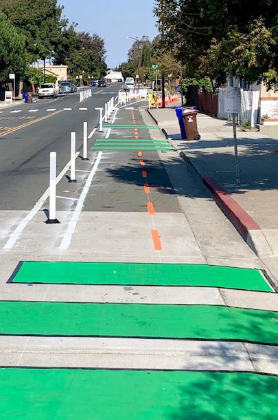
Construct permanent traffic calming measures.
Long-Term
Goal 1: Improve accessibility and mobility along Route 140.
Strategy 4: Reconcile dangerous or inefficient turns to pedestrian safety.
Funding Sources
COMPLETE STREETS
https://www.mass.gov/complete-streets-fundingprogram
MASSWORKS INFRASTRUCTURE PROGRAM
https://www.mass.gov/info-details/massworksinfrastructure-program
SAFE ROUTES TO SCHOOL INFRASTRUCTURE
https://www.mass.gov/safe-routes-to-school
TRANSPORTATION IMPROVEMENT PROGRAM (TIP)
https://srpedd.org/transportation/regionaltransportation-planning/transportation-improvementprogram-tip/
ADA IMPROVEMENT GRANT
https://www.mass.gov/municipal-americans-withdisabilities-act-grant


Enter projects into the TIP, Complete Streets, or other long range planning programs.
Short-Term
Identify priority projects and pursue temporary, low cost initiatives for a pilot program.
to improve vehicular, cyclist, and


Pursue more permanent funding programs for successful pilot initiatives.
Road improvements construction. Long-Term
Goal 1: Improve accessibility and mobility along Route 140.
Strategy 5: Reduce the number and size of curb cuts
Funding Sources
TRANSPORTATION IMPROVEMENT PROGRAM (TIP)
https://srpedd.org/transportation/regionaltransportation-planning/transportation-improvementprogram-tip/
ADA IMPROVEMENT GRANT
https://www.mass.gov/municipal-americans-withdisabilities-act-grant


Create design guidelines to define circulation and encourage shared parking for new developments.
Short-Term
Apply for ADA improvement grants to improve sidewalk conditions.


Identify property owners with whom the City can work to reduce curb cut volume.
Continue to evaluate the success of shared parking and curb cut reduction on the corridor.
Goal 2: Provide increased housing opportunities and highlight locations
Strategy 1: Identify areas along the corridor that are initiatives.
Funding Sources
MASSACHUSETTS COLLABORATIVE WORKSPACE PROGRAM
https://www.mass.gov/info-details/collaborativeworkspace-program
MASSDEVELOPMENT TRANSFORMATIVE DEVELOPMENT INITIATIVE
https://(https://srpedd.org/comprehensive-planning/ technical-assistance/dlta-program/)
COMMUNITY COMPACT CABINET –BEST PRACTICES PROGRAM
https://www.mass.gov/best-practice-program
COMMUNITY ONESTOP FOR GROWTH
https://www.mass.gov/guides/community-one-stopfor-growth
DISTRICT LOCAL TECHNICAL ASSISTANCE
https://(https://srpedd.org/comprehensive-planning/ technical-assistance/dlta-program/)


Identify friendly developers and provide information on high-priority parcels from the study.
Short-Term
Identify potential public-private partnerships opportunities to enhance public goods (such as increased access to the Wild & Scenic).
locations for economic development.
ripe for development and pursue collaborative


Pursue collaborations for highquality developments.
Evaluate successes and plan for future collaborations.
Goal 2: Provide increased housing opportunities and highlight locations
Strategy 2: Support recently adopted zoning changes Requirements.
Funding Sources
COMMUNITY ONESTOP FOR GROWTH
https://www.mass.gov/guides/community-one-stopfor-growth
MASSACHUSETTS HOUSING PARTNERSHIP SECTION 3A TECHNICAL ASSISTANCE PROGRAM
https://www.cognitoforms.com/ MassachusettsHousingPartnership/ CHAPA COMMUNITY ENGAGEMENT ASSISTANCE
https://www.chapa.org/mbta-zoning-technicalassistance


Pursue collaborative developments in the TOD Zone.
Short-Term
Continue to evaluate and monitor the district in attracting new multi-family
locations for economic development.


changes to comply with the Section 3A’s Multifamily Zoning the success of the current zoning


Consider opportunties to create more multi-family housing zoning in Taunton.
Goal 2: Provide increased housing opportunities and highlight locations
Strategy 3: Develop the recently adopted TOD district housing options.
Funding Sources
MASSACHUSETTS COLLABORATIVE WORKSPACE PROGRAM
https://www.mass.gov/info-details/collaborativeworkspace-program
MASSDEVELOPMENT
TRANSFORMATIVE DEVELOPMENT INITIATIVE
https://srpedd.org/comprehensive-planning/ technical-assistance/dlta-program/)
COMMUNITY COMPACT CABINET –BEST PRACTICES PROGRAM
https://www.mass.gov/best-practice-program
COMMUNITY ONESTOP FOR GROWTH
https://www.mass.gov/guides/community-one-stopfor-growth
DISTRICT LOCAL TECHNICAL ASSISTANCE
https://srpedd.org/comprehensive-planning/ technical-assistance/dlta-program/
Identify priority public realm priorities, potential street alignments, and urban design considerations.
Short-Term


Develop design guidelines that ensure the inclusion of City and public feedback priorities for future TOD neighborhood.
district into a vibrant neighborhood with a variety of


Long-Term locations for economic development.


Work with developers to ensure that new development projects capture the spirit of creating a walkable, liveable TOD neighborhood.
Continue to evaluate the success of the TOD neighborhood.
Goal 2: Provide increased housing opportunities and highlight locations
Strategy 4: Continue to attract high quality businesses and signage improvements program in the Downtown.
Funding Sources
HUD COMMUNITY DEVELOPMENT BLOCK GRANT
https://www.mass.gov/info-details/communitydevelopment-block-grant-cdbg
LISC CREATIVE PLACEMAKING TECHNICAL ASSISTANCE PROGRAM
https://www.arts.gov/impact/creative-placemaking
KRESGE FOUNDATION
Ongoing grant programs


Continue the City's successful façade and signage program.
Short-Term
Explore funding sources and loan programs that could expand Taunton's façade program.
Continue to expand façade and signage small businesses
businesses along the corridor building upon the City’s façade Downtown.


expand marketing and raise awareness of signage improvement opportunities. Educate businesses on the available funding mechanisms.


Long-Term locations for economic development.
Evaluate program success and explore opportunities for continued expansion.
Goal 2: Provide increased housing opportunities and highlight locations
Strategy 5: Incorporate design principles for future development also protecting existing residential areas.
Funding Sources
COMMUNITY COMPACT CABINET –BEST PRACTICES PROGRAM
https://www.mass.gov/best-practice-program
COMMUNITY ONESTOP FOR GROWTH
https://www.mass.gov/guides/community-one-stopfor-growth
DISTRICT LOCAL TECHNICAL ASSISTANCE
https://(https://srpedd.org/comprehensive-planning/ technical-assistance/dlta-program/


Pursue funding to produce design guidelines for the Route 140 corridor.
Short-Term
Integrate design guidelines into the development process.
locations for economic development.
development along key areas along Route 140 while


Consider rezoning key areas, exploring options such as density bonuses to encourage development at street intersections, as necessary.
Continue to evaluate and revise as necessary.
Goal 3: Prioritize placemaking to create a high-quality experience along
Strategy 1: Implement streetscape improvements to complement uses.
Funding Sources
MASS DEVELOPMENT TDI
https://www.massdevelopment.com/what-we-offer/ key-initiatives/tdi
SHARED STREETS AND SPACES GRANT
https://www.mass.gov/info-details/program-overviewshared-streets-and-spaces-grant-program
MASSWORKS INFRASTRUCTURE PROGRAM
https://www.mass.gov/info-details/massworksinfrastructure-program


Identify public realm and streetscape priorities along the Route 140 corridor.
Short-Term
Apply for grant programs to initiate streetscape improvements to improve walkability and attract development in critical areas.
along the 140 corridor.
complement adjacent land-


Work alongside developers to provide public realm enhancements as part of new developments along Route 140.
Monitor the success of streetscape and public realm improvements along the corridor.
Long-Term
Goal 3: Prioritize placemaking to create a high-quality experience along
Strategy 2: Provide enhanced and varied open spaces corridor.
Funding Sources
PARC GRANT
https://www.mass.gov/info-details/parklandacquisitions-and-renovations-for-communities-parcgrant-program
PROJECT FOR PUBLIC SPACES PLACEMAKING GRANT
https://www.pps.org/community-placemaking-grants
GATEWAY CITY PARKS PROGRAM
https://www.mass.gov/info-details/gateway-cityparks-program


Work with community groups, local school populations, and the public to identify potential land for open spaces and parks.
Short-Term
Pursue open space and public realm improvements as part of development agreements – particularly on properties closer to the corridor’s schools and in the TOD zone.

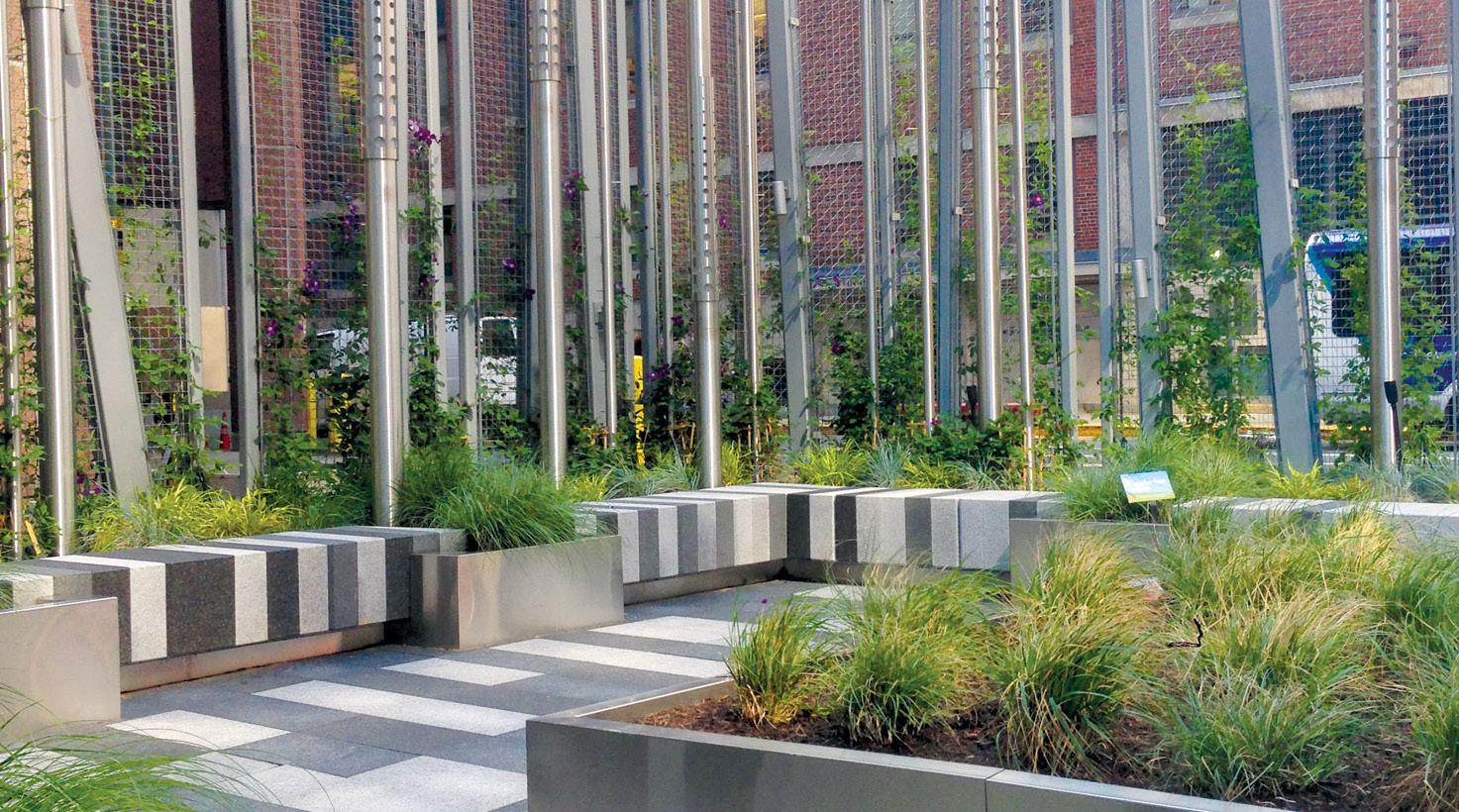


Match potential open space proposals with appropriate funding sources to pursue design and construction.
spaces along the Long-Term along the 140 corridor.

Continue with ongoing construction and monitor outcomes.
Goal 3: Prioritize placemaking to create a high-quality experience along
Strategy 3: Increase connection to the Wild & Scenic
Funding Sources
PARC GRANT
https://www.mass.gov/info-details/parklandacquisitions-and-renovations-for-communities-parcgrant-program
PROJECT FOR PUBLIC SPACES PLACEMAKING GRANT
https://www.pps.org/community-placemaking-grants
GATEWAY CITY PARKS PROGRAM
https://www.mass.gov/info-details/gateway-cityparks-program Short-Term
Pursue funding for signage and wayfinding to highlight connections to the Wild & Scenic.


Consider public private agreements for larger open spaces as properties with access to the river get redeveloped.
along the 140 corridor.


Identify smaller-scale opportunities for implementation, such as kayak launches, small fishing piers, and other similar opportunities on City-owned land that interfaces the river.
Monitor the success of park, signage, and public realm improvements along the corridor.