Your Open House Checklist: Sign in View the Master Plan Boards + Leave your feedback Talk to planners about any questions you may have
Head to the Master Plan website for more info
What is a Master Plan?
A Master Plan is a comprehensive, long-term guide that outlines the vision, goals, and strategies for the future development and growth of a community. A master plan serves as a blueprint for making decisions related to land use, housing, transportation, public facilities, natural resources, and other key areas to enhance the quality of life for residents.
Timeline
Jan 2025
June 2025
Kick-off Discovery Feedback Review Introduction
Data Collection
Mapping and Analysis
Literature Review
Discovery Open House
Community Survey Masterplan Committee
Established
Develop shared vision, priorities, and goals
Draft Goals and Strategies for public review
Dec 2025
Draft Plan for public review
Gather final thoughts Final Planning Board adoption of Plan
Between 2010 and 2020, Acushnet’s population increased by 2.5% which is comparable to Bristol County’s population increase.
Meanwhile, the share of Acushnet’s population of over 60 year olds has increased by 54% while the Town’s population of under 20 year olds has decreased by 17%.
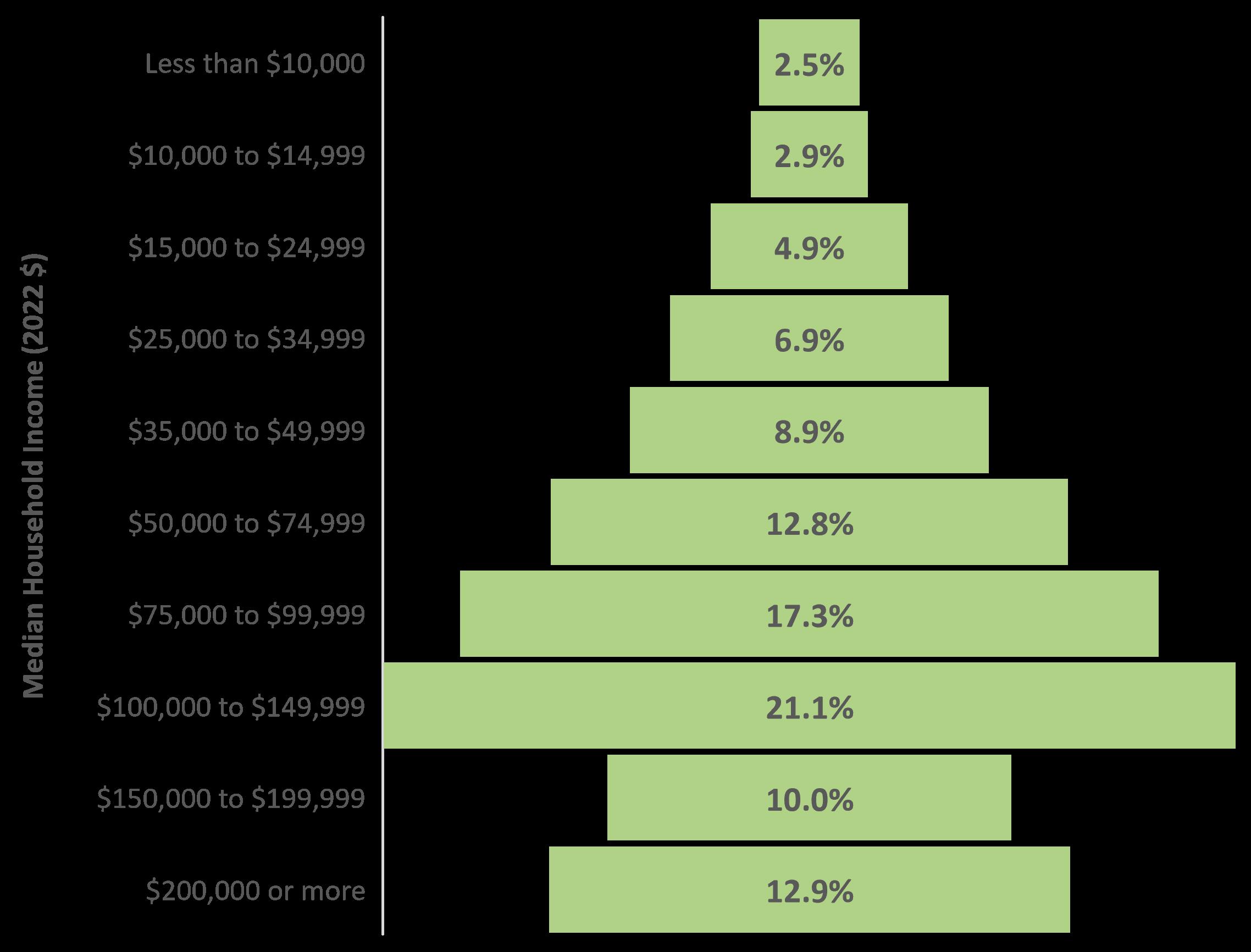
Income
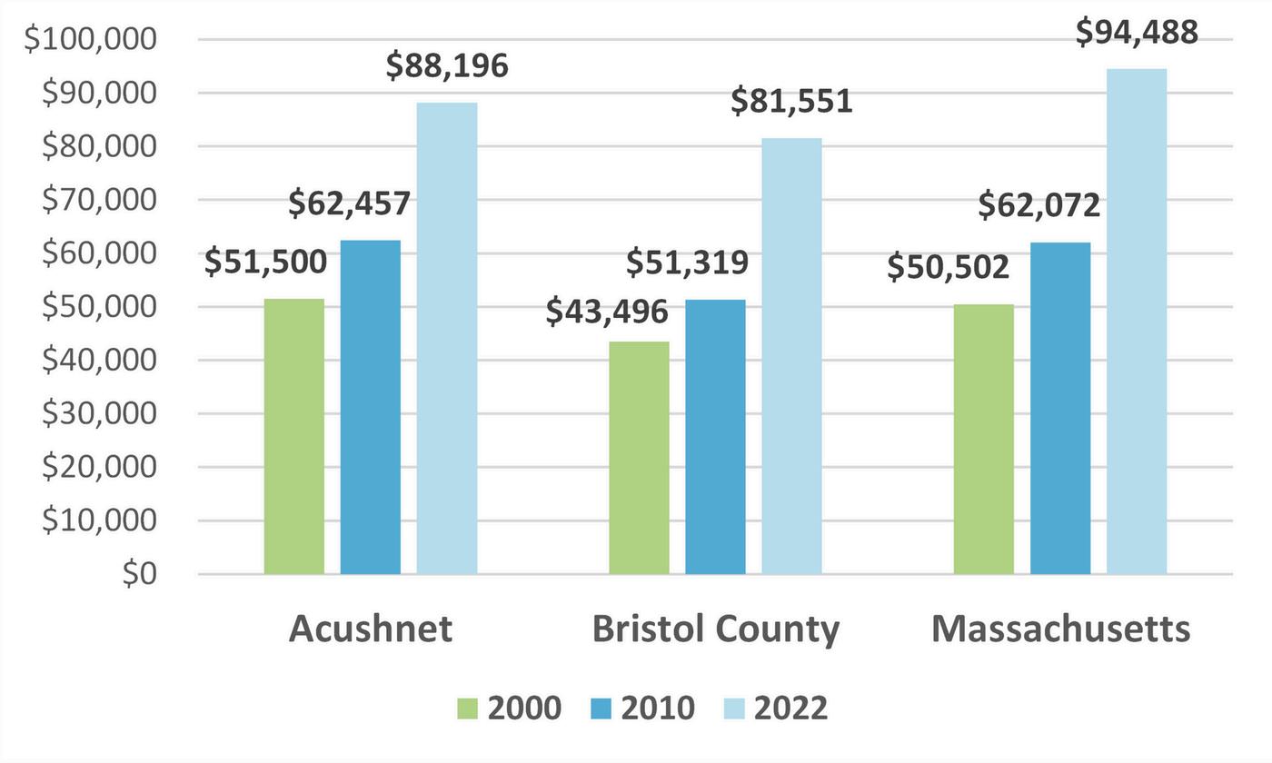
The median household income in Acushnet has increased steadily over the past two decades, from $51,500 in 2000 to $88,196 in 2022.
Housing
In Acushnet, 21% of owners and 24% of renters are considered cost burdened or “severely cost burdened ”*
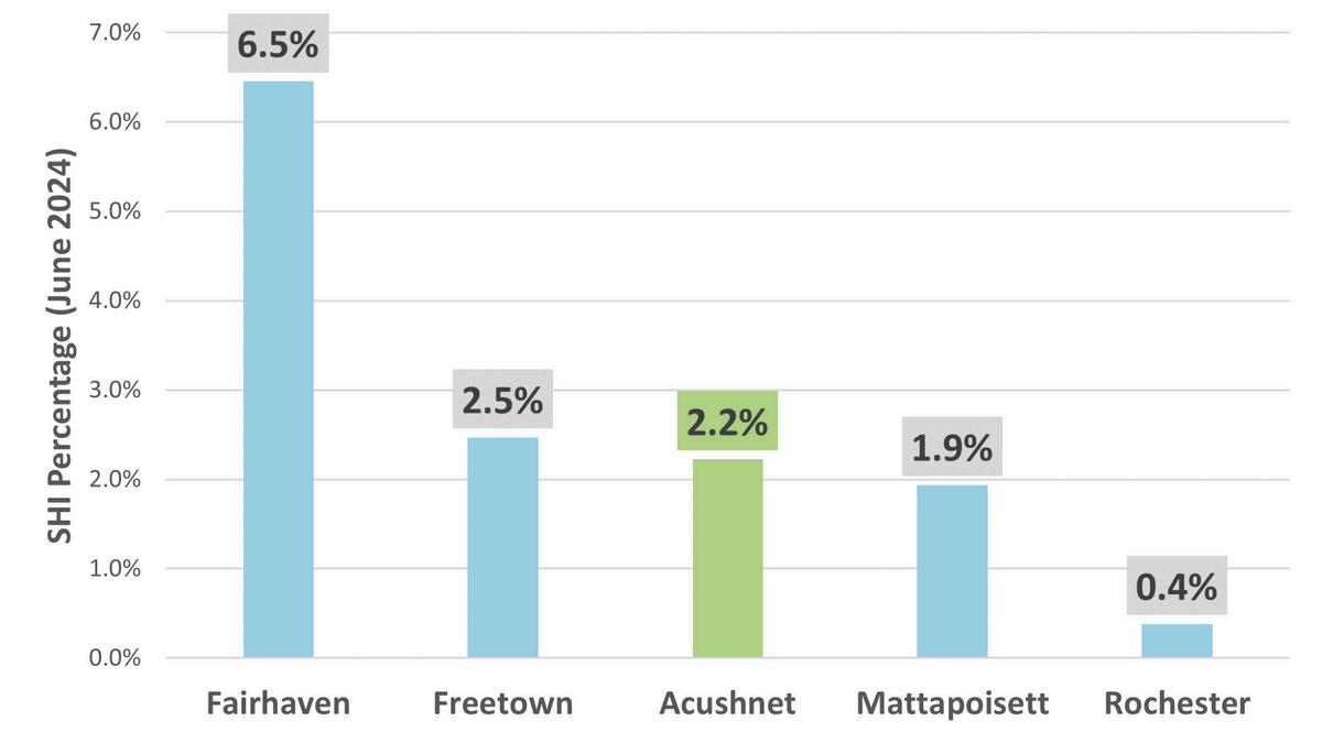
As of 2023, Acushnet’s Subsidized Housing Inventory is 2 22% of the housing stock Per M G L c 40B, the Commonwealth of Massachusetts requires at least 10% of a city or town’s housing stock to be subsidized affordable housing
Acushnet utilizes a Split Tax Rate, and has the highest residential tax rate of its immediate neighbors.
Commercial Tax Rate in Acushnet $16.14 per $1,000 in assessed value
Residential Tax Rate in Acushnet $11.41
Compared with
Learn more about town statistics here
Which services do you use most often to stay connected with the Town? Put a sticker next to them.
Town website
Social media
Public meetings and forums
Town newsletter
Community events
The Library
Where are we right now? What street do you live on? Where do you buy groceries? Where do your kids go to school?
1. Where would you take people who are in town for the first time?
2. What else would you like to learn about Acushnet?
Land Use
What is the land being used for?
Is the land being used for housing, shops, parks, or something else? How might land use change or stay the same?
What is “Institutional”?
This describes tax-exempt land owned by public or non-profit entities - such as the Town. This includes places like Town Hall, schools, and some open spaces or conservation land.
LAND USE
Res/Ag and Res/OS Residences
Economic Development
Where do you shop?
How can we continue to bolster the commmercial tax base? How can we support small businesses?
What are “Multiple Uses”?
Properties used for more than one purpose including parcels with multiple detached or attached buildings are considered multiple use. These may include buildings with a retail store on the first floor and apartments or offices on upper floors; single-family homes with designated open space; or farm property with land and buildings used for commercial farming.
BUSINESSES
Agriculture makes up 8% of total land use. With a strong agricultural history, the town has retained its rural character. See the breakdown of farming products in the map below.
Agriculture
Questions
1. Where do you like to shop and go out to eat in Acushnet? What other types of businesses would you like to see around town?
Business Commercial districts allow for minimum lots of 45,000 sq ft to be used for warehouses, light manufacturing, research laboratories and others.
How do we decide what goes where?
Different districts allow different land uses. Zoning also regulates density and dimensions of new buildings.
Business Village districts allow for minimum lots of 10,000 sq ft. Lots may be used for the same as Residential districts plus retail sales and services, and other uses.
ZONING
B usiness Vil lage
Residential districts require a minimum lot area of 60,000 sq ft. Permitted uses include:
• single-family home
• religious, public, or non-profit use
• town or government uses agriculture and aquaculture uses
• customary homes
• other uses not listed and by special permit
The majority of Acushnet is zoned as Residential.
Residential Village districts allow the same uses as Residential with additional uses by special permit such as:
• accessory apartments
• hospital or nursing home private school, nursery, or kindergarten
• veterinarian, animal hospital
• private garage or parking
• offices with street access and off-street parking
Industrial districts may be used for mining and quarry operations, office buildings, utility buildings, and asphalt/concrete operations which must be located more than fifty feet from residences.
Questions
1. Which areas in town feel well-connected?
Housing Housing comes in many shapes and sizes.
What should Acushnet’s housing priorities be over the next ten years? How can we plan for housing to support the next generation?
1. Take a look at the housing goals and strategies from Acushnet’s final draft Housing Production Plan. What actions should we prioritize from this plan?
• The average home sale price increased by about 50% since 2016, from $275,000 to $410,000
• Average incomes increased from $51,500 in 2000 to $88,196 in 2022.
How much do homes cost?
In Acushnet, 2.2% of the housing inventory is designated as Chapter 40B Subsidized Housing.
“cost burdened” if
or
Where are people going?
The highest trafficked roads are Main St and South Main St leading out from New Bedford. This is also one of the most dangerous intersections in the town.
Questions
How do you get around town?
No matter how you choose to get somewhere, you should feel safe and
1. How do you get around town? How do you wish you could get around town?
2. Are there any roads, sidewalks, or other areas you think need improvements?
Open Space
How do you spend time outside?
Open space includes parks, sports fields, hiking trails, and nature preserves. What’s your favorite open space?
This plan will also produce an Open Space and Recreation Plan (OSRP)!
Questions
1. Which open spaces do you enjoy the most? Why?
2. Are there recreational activities in town you would like to do but feel are unsupported?
An OSRP helps to protect and manage existing open spaces and natural resources. This will help towns become more eligible for funding from state grant programs.
What is an Open Space and Recreation Plan?
• An inventory of open spaces and recreational facilities.
• A blueprint to help community leaders manage resources and plan for the future.
• A resource for the community to learn about local open spaces and help with planning
Natural Resources
Protecting what’s important.
Acushnet is home to many sensitive natural landscapes that play a vital role in the local ecosystem.
What are Rare Species?
Rare species are wildlife found on the database of the Natural Heritage and Endangered Species Program list. These are threatened and endangered species native to this area.
Why are these habitats important?
Biomap Core Habitats are areas critical to the long-term persistence of rare species, exemplary natural communities, and resilient ecosystems. Critical Natural Landscapes are large tracts of land that are minimally impacted by development along with core habitat buffers.
Questions
1. How do you enjoy nature in Acushnet?
2. What is needed to support local wildlife and landscapes in town?
Water Resources
Water is a finite resource.
The Acushnet River provides drinking water, recreation, and habitat space to Acushnet and the Greater New Bedford area.
What are Aquifers?
Aquifers are underground water sources that are refilled by precipitation. High yield aquifers produce over 300 gallons per minute when pumped, medium yield produces 100-300 gpm, and low yield produces less than 50 gpm.
AQUIFERS
Wetlands
High Yield Aquifer
Medium Yield Aquifer
Approved Zone II Aquifers
Interim Wellhead Protection Area
Water bodies
Questions
1. How do you feel about the water quality in Acushnet?
2. What types of clear water initiatives would you like to see in town (trash clean up, water quality restoration, invasice species management, etc.)?
3. How do you feel about water recreation access in town?
This plan will also produce a Water Resources Management Plan! A Water Resources Management Plan helps towns to maintain clean water for drinking supply, active and passive recreation, and habitat.
What will the Water Resources Management Plan address?
• Keep water local and seek to have municipalities live within their water budgets by addressing issues from a watershed perspective.
• Protect clean water and restore impaired waters.
• Protect and restore fish and wildlife habitat.
• Promote development strategies consistent with sustainable water resource management.
PDA/PPA Planning for the future.
Where do you want to see development in town? Which areas do you want to remain the same?
What are PPAs?
Priority Protection Areas (PPAs) are environmentally or culturally important areas in town that might benefit from protection against futher development.
What are PDAs?
Priority Development Areas (PDAs) are central “hubs” of a town, well-connected to sidewalks, public transit, and public amenities.
What are Combined areas?
Combined areas are areas that may be wellsuited for development, but have environmental considerations to be aware of.
Questions
1. What kind of development would you like to see? Are there stores or restuarants that are missing in town?
2. What kind of protection areas would you like to see? Do you want more hiking trails, parks or preserved nature?
Open Space
How do you spend time outside?
Open space includes parks, sports fields, hiking trails, and nature preserves. What’s your favorite open space?
This plan will also produce an Open Space and Recreation Plan (OSRP)!
Questions
1.Which open spaces do you enjoy the most? Why?
2.Are there recreational activities in town you would like to do but feel are unsupported?
An OSRP helps to protect and manage existing open spaces and natural resources. This will help towns become more eligible for funding from state grant programs.
What is an Open Space and Recreation Plan?
• An inventory of open spaces and recreational facilities.
• A blueprint to help community leaders manage resources and plan for the future.
• A resource for the community to learn about local open spaces and help with planning
Natural Resources
Protecting what’s important.
Acushnet is home to many sensitive natural landscapes that play a vital role in the local ecosystem.
What are Rare Species?
Rare species are wildlife found on the database of the Natural Heritage and Endangered Species Program list. These are threatened and endangered species native to this area.
Why are these habitats important?
Biomap Core Habitats are areas critical to the long-term persistence of rare species, exemplary natural communities, and resilient ecosystems. Critical Natural Landscapes are large tracts of land that are minimally impacted by development along with core habitat buffers.
Questions
1. How do you enjoy nature in Acushnet?
2. What is needed to support local wildlife and landscapes in town?
Water Resources
Water is a finite resource.
The Acushnet River provides drinking water, recreation, and habitat space to Acushnet and the Greater New Bedford area.
What are Aquifers?
Aquifers are underground water sources that are refilled by precipitation. High yield aquifers produce over 300 gallons per minute when pumped, medium yield produces 100-300 gpm, and low yield produces less than 50 gpm.
AQUIFERS
Wetlands
High Yield Aquifer
Medium Yield Aquifer
Approved Zone II Aquifers
Interim Wellhead Protection Area
Water bodies
Questions
1. How do you feel about the water quality in Acushnet?
2. What types of clear water initiatives would you like to see in town (trash clean up, water quality restoration, invasice species management, etc.)?
3. How do you feel about water recreation access in town?
This plan will also produce a Water Resources Management Plan! A Water Resources Management Plan helps towns to maintain clean water for drinking supply, active and passive recreation, and habitat.
What will the Water Resources Management Plan address?
• Keep water local and seek to have municipalities live within their water budgets by addressing issues from a watershed perspective.
• Protect clean water and restore impaired waters.
• Protect and restore fish and wildlife habitat.
• Promote development strategies consistent with sustainable water resource management.
PDA/PPA Planning for the future.
Where do you want to see development in town? Which areas do you want to remain the same?
What are PPAs?
Priority Protection Areas (PPAs) are environmentally or culturally important areas in town that might benefit from protection against futher development.
What are PDAs?
Priority Development Areas (PDAs) are central “hubs” of a town, well-connected to sidewalks, public transit, and public amenities.
What are Combined areas?
Combined areas are areas that may be wellsuited for development, but have environmental considerations to be aware of.
AREAS
Questions
1.What kind of development would you like to see? Are there stores or restuarants that are missing in town?
2.What kind of protection areas would you like to see? Do you want more hiking trails, parks or preserved nature?