Community Priority Areas of Regional Significance
South Coast Rail Corridor Plan 2024 Update


South Coast Rail Corridor Plan 2024 Update
The Southeastern Massachusetts Metropolitan Planning Organization (SMMPO) through the Southeastern Regional Planning and Economic Development District (SRPEDD) operates its programs, services, and activities in compliance with federal nondiscrimination laws including Title VI of the Civil Rights Act of 1964 (Title VI), the Civil Rights Restoration Act of 1987, and related statutes and regulations. Title VI prohibits discrimination in federally assisted programs and requires that no person in the United States of America shall, on the grounds of race, color, or national origin (including limited English proficiency), be excluded from participation in, be denied the benefits of, or be otherwise subjected to discrimination under any program or activity receiving federal assistance. Related federal nondiscrimination laws administrated by the Federal Highway Administration, the Federal Transit Administration, or both prohibit discrimination on the basis of age, sex, and disability. These protected categories are contemplated within SRPEDD’s Title VI Programs consistent with federal interpretation and administration. Additionally, SRPEDD provides meaningful access to its programs, services, and activities to individuals with limited English proficiency, in compliance with US Department of Transportation policy and guidance on federal Executive Order 13166.
Individuals seeking additional information or wishing to file a Title VI/Nondiscrimination complaint may contact the SRPEDD Title VI/Nondiscrimination Coordinator at the contact information here. All such complaints must be received, in writing, within 180 days of the alleged discriminatory occurrence. Assistance will be provided, upon request, to individuals unable to provide the complaint form in writing.
Title VI Coordinator -SRPEDD
88 Broadway, Taunton, MA 02780
Phone: 508 824-1367 or dial 711 to use MassRelay
Email: aduarte @srpedd.org
Massachusetts Public Accommodation Law (M.G.L. c 272 §§92a, 98, 98a) and Executive Order 526 section 4 also prohibit discrimination in public accommodations based on religion, creed, class, race, color, denomination, sex, sexual orientation, nationality, disability, gender identity and expression, and veteran’s status, and SRPEDD and the SMMPO assures compliance with these laws. Public Accommodation Law concerns can be brought to SRPEDD’s Title VI / Nondiscrimination Coordinator or to file a complaint alleging a violation of the state’s Public Accommodation Law, contact the Massachusetts Commission Against Discrimination within 300 days of the alleged discriminatory conduct.
The SMMPO is equally committed to implementing federal Executive Order 12898, entitled “Federal Actions to Address Environmental Justice in Minority Populations and Low-Income Populations” and Executive Order 13985 (2021) entitled “Advancing Racial Equity and Support for Underserved Communities Through the Federal Government.”
In this capacity, the SMMPO identifies and addresses disproportionately high and adverse human health or environmental effects of its programs, policies, and activities on low-income and minority, including BIPOC, Asian or Pacific Islander populations, as well as religious minorities, LQBTQ+ persons, Limited English Proficient (LEP) persons or those who have a disability. The SMMPO carries out this responsibility by the consistent, fair, just, and impartial treatment of all individuals, and by involving underserved individuals in the transportation process and considering their transportation needs in the development and review of the SMMPO’s transportation plans, programs and projects.
English: If this information is needed in another language, please contact the MPO Title VI Coordinator at 508-824-1367 ext. 235 or at aduarte @srpedd.org
Spanish: Si necesita esta información en otro idioma, por favor contacte al coordinador de MPO del Título VI al 508-824-1367 ext. 235 o en aduarte @srpedd.org
Portuguese: Caso estas informações sejam necessárias em outro idioma, por favor, contate o Coordenador de Título VI da MPO pelo telefone 508-824-1367, Ramal 235 ou em aduarte @ srpedd.org
Haitian Creole: Si yon moun bezwen enfòmasyon sa a nan yon lòt lang, tanpri kontakte Koòdonatè a Title VI MPO nan 508-824-1367 ext. 235.
Simplified Chinese: 如果需要其他语言的此信息,请致电 508-824-1367 分机联系 MPO Titl e VI 协调员。 235 或发送电子邮件至 aduarte @srpedd.org 。
Simplified Chinese: 如果需要其他语言的此信息,请致电 508-824-1367 分机联系 MPO Titl e VI 协调员。 235 或发送电子邮件至 aduarte @srpedd.org 。
Traditional Chinese: 如果需要其他語言的此信息,請致電 508-824-1367 分機聯繫 MPO Tit le VI 協調員。 235 或發送電子郵件至 aduarte @srpedd.org 。
Mon Khmer Cambodian (Khmer): ប្រសិនបើព័ត៌មាននេះត្រូវការជាភាសាផ្សេង សូមទាក់ទង អ្នកសម្របសម្រួល MPO Title VI តាមរយៈលេខ 508-824-1367 ext ។ 235 ឬនៅ aduarte @ srpedd.org ។
All photography within this report was captured by SRPEDD, unless otherwise stated.
Maps produced by SRPEDD are for the sole purpose of aiding regional planning decisions and are not warranted for any other use. These maps are not intended for engineering, legal, or survey purposes. Data sources for the maps within this report include MassGIS, MassDOT, MBTA, and SRPEDD.
SRPEDD (and its sister Regional Planning Agencies, OCPC and MAPC) last identified and defined Community Priority Areas of Regional Significance in 2013 as part of the continued planning for the South Coast Rail project. Over the past 18 months, SRPEDD once again worked with the 27 communities in its service area to update and redefine their local priority area designations. Through a series of working sessions and online and in-person meetings, SRPEDD supported the efforts of municipal officials and other participants to delineate new local priorities using modern Geographic Information Systems (GIS) and mapping techniques. This process created an updated set of local priority areas that fell into one of three categories: Priority Development Areas (PDAs), Priority Protection Areas (PPAs), and Combined Areas.
Working from this new collection of local designations,1 SRPEDD then endeavored to determine which of these 2024 community PDAs and PPAs were of regional significance. Regionally Significant priority areas are those that are best suited to help meet state and regional goals for development and conservation in our service area. In general, Priority Development Areas scoring in the
top 25th percentile and Priority Protection Areas scoring in the top 50th percentile were designated as “Regionally Significant,” with some exceptions due to resiliency concerns; examples of these exceptions are given below. In order to objectively compare all community priority areas, SRPEDD built upon the 2013 “Regional Screening” process to produce a data-rich, but simplified methodology criteria that analyzed each site’s suitability for development or protection.
In general, PDAs are more suitable based on three main components: (1) their proximity to development assets (such as water and sewer); (2) their proximity to public amenities that promote increased transit use, job creation, housing production, and walkability; and (3) their distance from key environmental features.2 PPAs are more suitable based on their capacity to preserve and protect existing green spaces and important habitats while minimizing the impact of climate change and development. Using this methodology, SRPEDD identified top scoring PDAs and PPAs to recommend for regional significance; in some cases, these areas may help identify priorities for regional and state funding opportunities.
1 In total, in 2024, SRPEDD’s 27 Communities identified 175 PPAs (191,673.29 acres), 179 PDAs (30,312.16 acres), and 69 Combined Areas (7,715.43 acres).
2 Please note that Combined Areas were evaluated in conjunction with PDAs. Combined Areas balance development and protection in environmentally sensitive or historically significant areas.
Community Priority Development Areas (PDAs) were designated by each of our 27 communities to find areas within each town that are well-positioned to support economic and, in some cases, residential growth. PDAs of Regional Significance were chosen by comparing suitability scores across the region. These PDAs are often located in walkable areas with alternative transportation options, close to civic amenities such as schools and hospitals, and connected to available water and sewer infrastructure.
In this update of our selection methodology, climate resilience is considered as one of the main factors in designating Regionally Significant areas. Given the coastal character of the region, many of our communities may be affected by flooding, major storms, and other natural disasters/hazards within the next decade. Therefore, Regionally Significant PDAs are unlikely to be located near wetlands, flood zones, and hurricane surge inundation zones, or within environmentally sensitive areas.
The selected PDAs of regional significance are determined to best support state and regional goals for development. Some examples of Regionally Significant PDAs may include Chapter 40R Districts, industrial parks, and proposed/existing commuter rail station sites. Development within regional PDAs may be prioritized for state grants.
Community Priority Protection Areas were similarly designated by each municipality to find areas that preserve important environmental and cultural resources within each town. Regionally significant PPAs preserve important habitats for rare or endangered species, municipal water supplies, historic vistas, and farmland. SRPEDD also considered whether the PPA could help increase the climate resilience of surrounding areas by providing flood protection and drainage basins for nearby water features. Selected regional PPAs may be candidates for protection through acquisition or conservation restrictions.
In order to assess Regionally Significant priority development and protection areas, SRPEDD used a GIS-based, data-driven tool to guide its selections.3 This tool assigns a Suitability Score to each priority area. Suitability scores were calculated based on a number of factors with different weighting criteria for development (Table 1) and protection (Table 2). SRPEDD also developed two different Scenarios – (1) “Business As Usual” and (2) “Climate Resilience” – to allow for different perspectives (represented by different weighting criteria) in each Scenario (Table 1).4 Finally, in addition to consulting Suitability Scoring, SRPEDD evaluated State Sustainable Development Principles, state programs and policies, and community input to compile its preliminary list of Regionally Significant Priority Development and Protection Areas.
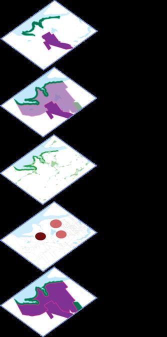
Figure 1: Regional significance was determined by calculating a Suitability Score for Community PDA/PPAs using data layers that affect development and the environment.
3 The 2013 Regional Screening process also used a Suitability Scoring approach.
4 Please note that the Climate Resilience Scenario is a major addition to the process; the 2013 Regional Screening efforts did not explicitly consider resilience to climate factors.
Table 1 (Pages 12-13): PDA Suitability Scoring Groups and Weights by Scenario.
Sites near public wells or aquifers receive lower scores due to development impacts on public water supplies.
Sites previously designated as PDAs receive higher scores.
Sites within 3A /43D/40R districts indicate private sector investments are already in place or planned and receive higher scores.
High scores indicate the site shows high resilience to climate impacts.
The site is not located in flood zones, hurricane surge inundation zones, or areas expected to be affected by sea level rise.
High scores indicate site allows options to walk or bike to nearby destinations.
Civic amenities such as hospitals and schools are nearby.
Sidewalks, bike routes and public transit options are available nearby.
The site likely has better air quality due to decreased traffic congestion.
High scores may indicate the site is currently already developed or a degraded natural area.
Sites near priority habitats of rare species and wild areas may be impacted by development or may delay permitting
High scores may indicate the site is located near highway interchanges.
High scores may indicate the site is away from bedrock deposits.
Table 2: PPA Suitability Scoring Groups and Weights by Scenario.
High scores indicate the site includes public well or aquifers to help protect public water supplies.
High scores indicate the site includes coldwater fisheries habitats.
High scores indicate the site was previously designated as a PPA in 2013.
High scores indicate the site helps to preserve wetlands and natural buffers to increase climate resilience.
High scores indicate the site contains important habitats, critical landscape areas, and open spaces.
In general, many of the 2013 Community Priority Areas of Regional Significance retain that designation in 2024. This demonstrates continuity in local and regional planning priorities and remaining development potential for these sites. The minor changes to the final selection of 2024 Community Priority Areas of Regional Significance typically fell into one (or more) of the following categories:
1. A community removed the priority area from consideration.
2. An existing 2013 PDA or a new 2024 PDA performed well (and became a new designation) or performed poorly (and was removed) in the Climate Resilience Scenario.
3. A 2013 PPA or a new 2024 PPA performed well (and became a new designation) in the Climate Resilience Scenario.
4. A new 2024 PDA or PPA performed well (and became a new designation) in the Business As Usual Scenario.
Table 3: Comparison of total area of regional PDAs and PPAs from 2013 to 2024.
Map 1 (Right): 2024 Priority Areas of Regional Significance in solid colors and 2013 Priority Areas of Regional Significance in hatching.
Priority Areas
Regional PDAs
Regional PDAs
Regional PPAs
Regional
MBTA Comm uter Rail Lines
Regular Ser vice Seasonal/Special Events
Under Constr uction Proposed

MBTA Comm uter Rail Stations
Regular Ser vice Seasonal/Special Events
Under Constr uction Proposed
The Priority Development Areas (and Combined Areas) chosen by each community were scored according to the same criteria. As described previously, the screening tool evaluates a variety of site indicators (e.g., highway proximity, proximity to public transit, sidewalks, walkability index, and existing designation as a 2013 Community Priority Area of Regional Significance); these indicators (GIS layers) are categorized into six thematic criteria groups (Water Resources, Priority Area 2013, Climate Resilience, Civic Amenities, Natural Spaces, and Development Considerations) (Table 1); the tool assigns an overall group score for each of the criteria based on the location of the PDA in relation to these factors. For example, a PDA located close to a transit station with a high walkability
score, and situated away from wetlands and FEMA flood zones will score more favorably. These group scores are further combined into a weighted average Total Suitability Score to compare PDAs with each other.
As described earlier, suitability scores were calculated for two scenarios: a “Business As Usual” Scenario, and a “Climate Resilience” Scenario. The Climate Resilience Scenario prioritizes long-term sustainability by increasing the weight of climate-resilience indicators (as shown in Table 1) in the scoring process. To determine the final list of Regionally Significant PDAs, SRPEDD considered an area’s suitability score in both scenarios.
Table 4 (Pages 17-18): Regionally significant PDAs 2024, sorted by municipality. Asterisked (*) PDAs are ranked as the top 10 in the Climate Change Scenario. The (+) indicates the inclusion of this PDA despite a lower ranking in the BAU scenario due to its climate resilience.
In the 2024 review of PDAs, SRPEDD included the Climate Resilience scenario to find areas that are well-positioned to withstand flooding, drought, and extreme weather. Due to the coastal character of much of the SRPEDD region, many communities will begin to see the effects of climate change in the coming decades. Development in areas that have resilience factors should be prioritized for long-term sustainability.
The asterisked PDAs (Table 4) rank within the top 10 for the Climate Scenario. These areas show high potential for development, especially through a climate change sensitive perspective. Factors such as sea level rise,
more powerful hurricanes, and increased flooding will affect these areas less than other Regional PDAs, according to data from The Nature Conservancy and FEMA. In addition to positive development factors such as proximity to train stations and other civic amenities, these areas are located away from wetlands, flood zones and exhibit resilience from flooding and drought. In the case of the Downtown and TOD (211-03) PDA in North Attleboro, its ranking in the BAU scenario did not indicate regional significance, but, through a climate resilience perspective, it performs much better and was determined to be Regionally Significant.
Priority Protection Areas chosen by each community have a number of purposes, including protecting important habitats, creating recreational areas, highlighting areas of historical or cultural significance, and increasing resiliency of waterfront areas. Similar to the PDA regional screening process, the tool evaluates a variety of site indicators (e.g., proximity to wetlands, aquifers, coldwater fisheries, priority habitats, and open spaces, as well as an existing designation as a 2013 Community Priority Area of Regional Significance); as previously described, these indicators are categorized into six thematic criteria groups (Water Resources, Priority Area 2013, Climate Resilience, and Natural Spaces) (Table 2) and assigned a group score
for the criteria based on the indicators within that group. These were further combined to create a weighted average Suitability Score to compare PPAs with each other.
Similar to the PDA scoring, we also examined the climate resilience of Regionally Significant PPAs. Areas that protect shorelines and allow for increased flooding drainage (such as wetlands) are beneficial to the long-term sustainability of the SRPEDD region. PPAs that score highly in this Climate Resilient scenario can contribute to the long-term resiliency of the region.
Table 5 (Pages 20-23): Regionally significant PPAs 2024, sorted by municipality. Asterisked (*) PPAs are ranked as the top 10 in the Climate Resilience scenario. The (+) indicates the inclusion of a PPA due to its Climate Resilience score.
Similar to the PDA evaluation, the Climate Resilience Suitability Score was calculated by increasing the weight of factors that consider climate change and sustainability. We examined PPAs scoring in the top 50% of the BAU scenario to determine Regionally Significant PPAs, many of which also were designated Regionally Significant in 2013. We then added areas that scored well in the Climate Scenario, even if they were not among the top 50% in the BAU scenario, as the preservation of these areas can help to alleviate the effects of climate change. PPAs that show increased significance in the Climate Resilient Scenario are areas
that may buffer against severe storm events and increase drainage during flooding, for example. These areas characteristically have hydric soils (soil made of organic matter that are saturated with water for a significant portion of the year), which make them unsuitable for development, but can act as a buffer and prevent flooding of developments upstream. In general, PPAs that scored well in the BAU scenario typically scored well in the Climate Resilience scenario, with some exceptions. The Climate Resilience Scenario was not used to remove any PPAs from consideration for Regional Significance.
Beginning with community-designated Priority Areas, the Regional Screening process prioritizes development and preservation areas for the SRPEDD region. These Community Priority Areas of Regional Significance help to support the goals and strategies of the region (a) by being driven by city and town priorities and (b) by performing well in the rich data-driven GIS suitability screening described above. Using a similar methodology from the 2013 Priority Area Update, SRPEDD calculated a suitability score for each priority area to compare all areas. In the 2024 update, SRPEDD also examined a Climate Resilience Scenario to ensure consideration of long-term resilience
for the region. The total acreage of the final Regionally Significant Priority Areas between 2013 and 2024 remains similar and builds on analysis from the 2013 screening. The resulting final Regional Priority Areas reflect continuity in community and regional planning efforts and demonstrate the region’s commitment to realistic and balanced development and preservation. In short, these updated designations support long-term regional goals, ensuring that both development and conservation efforts are based in community priorities and strategically aligned with complementary regional and state efforts.