2 minute read
Context through Kevin Lynch’s eyes


There is a hierarchy of landmarks in the area. The most immediate landmark is Lewes Station, but there are other structures that whilst may not be seen as a primary landmark, are relevant locally: The Station Bridge and the Depot Cinema. A town-important landmark is Lewes Castle, from which panoramic views of the town and wider landscape can be enjoyed, and which can be seen from many vantage points. Whilst the castle functions as a town important landmark, it is less relevant in the site’s location, as the Depot Cinema and the Station become more prominent to observers and are clear contrasting elements of this space, making the location of the site more easily identifiable than the castle.
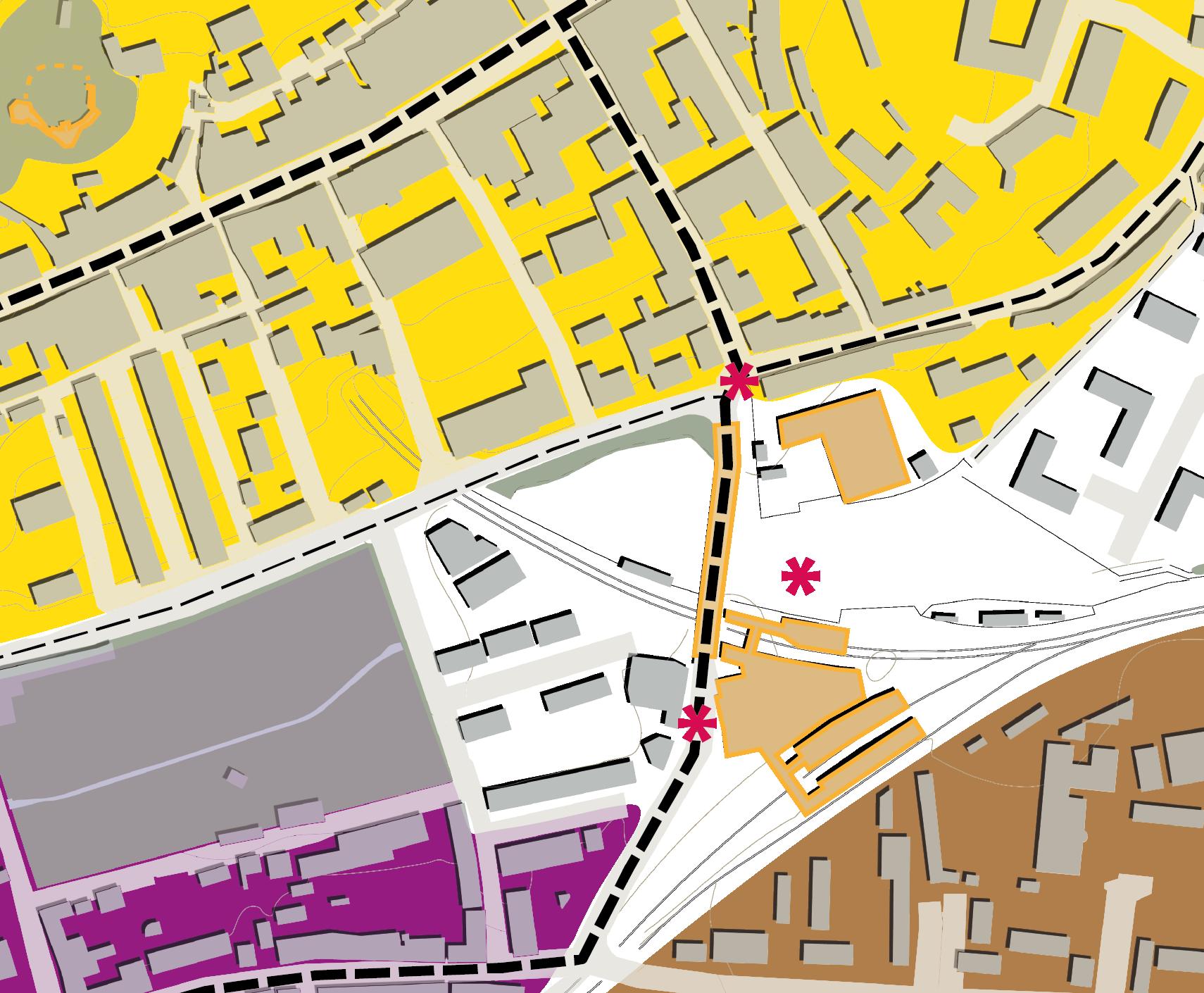
Nodes
Advertisement


Nodes are not easy to identify at this scale, but there are some points in the locality that could be considered quasi-nodes of a small scale. In these spots, the observer accesses a junction of activity, people, a focal point, an overall thematic concentration.
The main node is the railway station itself and its approaches, as well as it connects to a principal route in the area: Station Road. Another node would be junction of Station Road, Southover Road and Landsdown Place, an important vehicular and pedestrian meeting point immediately north of the site.
Routes
Routes or paths in Lewes play a significant role in the environmental perception of Lewes. These channels in which observers move, support an understanding of the town’s structure, from High Street to district’s main streets, from higher to lower ground, commercial and residential uses, distinctive character of districts, they also create, reinforce and reveal landmarks in a diversity of ways.
When visiting the site, one clearly identifies some of Lynch’s urban elements. For instance, as one approaches the site, travel takes place through a route. There are a number of perimetrical routes that abut the site, an important route that cuts it across into two and then a network of informal, changing and confusing desire lines throughout most of the site.
All routes from north to south are characterised for being relatively narrow, only one serving vehicle traffic through, with buildings immediate adjacent, and above all, steep topography. Buildings along the route are usually between 2 and 3 storeys and step down with the natural landform. Routes, through their design and the buildings and gaps around, are the most powerful element in the area to order the set of urban elements.
Edges
There is also a clear edge to the area formed by the railway line and the Railway Land to the east, as there is a physical boundary that forms two distinctive areas on both sides. Whilst not impenetrable, the continuity of the railway as well as the visibility of a district different in character beyond, define the railway as a linear edge in town.
Districts Defining districts is a more difficult task to do, as the area in question could be considered an anomaly, a gap in the urban theme. Southover is the most immediate neighbourhood to the west, mostly residential. The area to the north has a closest relationship with the High Street and the core of the town and has mixed commercial and residential theme, whilst the eastern areas are mostly formed by 20th century residential suburban development that lacks any connection to Lewes.
Kevin Lynch’s application of districts requires significant research in practice. Therefore, in order to save time and rely on solid evidence, I consulted the Conservation Area Character Appraisal and Management Plan (CAAMP) of Lewes, which is being produced by the SDNPA at the moment.
The CAAMP splits the Conservation Area into character areas based on what makes these areas physically distinctive from other. Based on the character assessments, I have identified three main districts aqround the site, none of which encroaches into the site, as the site feels clearly as a gap in town, not capable of being identified as part of it, or any of its thematic areas.


