Property Book 977 Trailcrest

Page 1

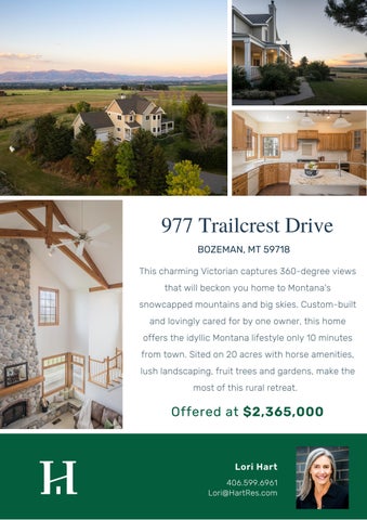
977 Trailcrest Drive BOZEMAN, MT 59718 This charming Victorian captures 360-degree views that will beckon you home to Montana's snowcapped mountains and big skies. Custom-built and lovingly cared for by one owner, this home offers the idyllic Montana lifestyle only 10 minutes from town. Sited on 20 acres with horse amenities, lush landscaping, fruit trees and gardens, make the most of this rural retreat.

Offered at $2,365,000

Lori Hart 406.599.6961 Lori@HartRes.com


Property Features 4 Bedrooms, 3.5 Bathrooms

Horse Amenities

4,186 SF

2 Separate Pastures

20.018 Acres

Fiber Optic Internet

2 Car Attached Garage Private Well & Septic Cross Fencing


1800 WEST KOCH, BOZEMAN, MT 59715 POST OFFICE BOX 396 – BOZEMAN, MT 59771-0396 PHONE (406) 587-5563 – (406) 586-3114 - 1-800-405-5299 FAX (406) 587-8038

PROPERTY PROFILE Legal Description: Certificate of Survey No. 1244, Tract 24 Agency: Hart Real Estate Customer: Lori Hart Date: April 21, 2022 This report is provided to assist you with your new listing. The information contained herein is not the result of a title examination and is not a commitment to insure. So that your closing will not be delayed by title problems, you should order a Commitment for Title insurance as soon as you have a signed Buy/Sell. We appreciate the opportunity to serve you and look forward to working with you again.

WE APPRECIATE YOUR BUSINESS


April 21, 2022

Hart Real Estate

Hello Lori, Please find attached the Property Profile you requested for 977 Trailcrest Dr., Bozeman. It has been a pleasure to be of service to you. Should you require another Property Profile at any time in the future, please do not hesitate to give us a call at (406) 587-5563 Sincerely, Daniel Stratton Customer Service 406-587-5563


VESTING DEED


EXPRESSLY DISCLAIMS ANY LIABILITY FOR ALLEGED LOSS OR DAMAGE WHICH MAY RESULT FROM RELIANCE UPON THEM.


EXPRESSLY DISCLAIMS ANY LIABILITY FOR ALLEGED LOSS OR DAMAGE WHICH MAY RESULT FROM RELIANCE UPON THEM.


TAX RECORD AND BILL


Tyler Technologies - iTax

1 of 2

https://itax.gallatin.mt.gov/detail.aspx?taxid=RGF31602

Shopping Cart: 0 items [$0.00]

Property/Parcel TaxID: RGF31602

Mailing Address: 977 TRAILCREST DR BOZEMAN, MT 597187537

Status: Current Receipt: 31602

Levy District: 2350-13, 7R Bozeman(R)GGF-GP

2021 Owner(s): LAWSON ARTHUR & OLSON LAURYNN

2021 Value: Market: Taxable:

$726,993 $9,159

2021 Payments:

2021 Taxes: First Half: Second Half: Total:

$2,179.95 $2,179.93 $4,359.88

Due: 12/15/2021 Due: 5/31/2022

First Half: Second Half: Total:

$2,179.95 $2,179.93 $4,359.88

(May include penalty & interest)

2021 Legal Records: Geo Code: 06-0797-16-4-01-10-0000 Instru#: 2719582 Date: 2021-02-03 Property address: 977 TRAILCREST DR, BOZEMAN MT 59715 TRS: T02 S, R04 E, Sec. 16 Legal: S16, T02 S, R04 E, C.O.S. 1244, PARCEL 24, ACRES 20.018

Note:

If you are having trouble using this search page, please contact our office at 406-582-3030 - Extension #2. If you believe there is an error on the property owner’s name, geo-code, address, etc.., or have questions regarding your market and/or taxable value, please contact the Montana Department of Revenue – Bozeman Office, at 406-582-3400. *The accuracy of this data is not guaranteed. Property tax data was last updated 04/21/2022 04:00 PM.

Payments can be sent to:

EXPRESSLY DISCLAIMS ANY LIABILITY FOR ALLEGED LOSS OR DAMAGE WHICH MAY RESULT FROM RELIANCE UPON THEM. 4/21/2022,

4:09 PM


Tyler Technologies - iTax

1 of 2

https://itax.gallatin.mt.gov/classcodes.aspx

Shopping Cart: 0 items [$0.00]

Property/Parcel TaxID: RGF31602 Status: Current Type: RE Owner: LAWSON ARTHUR &

Value Breakdown: Year Property/Parcel TaxID Class Code

Description

Market Value Taxable Value

2021 RGF31602

2002

1 Acre Bldg. Site On Non-Qualified Ag Land

2021 RGF31602

2137

Property Tax Asst. Land 30% reduction

2021 RGF31602

3142

Property Tax Asst. Improvements 30% Reduction

2021 RGF31602

3301

Improvements on Rural Land

2021 RGF31602

1701

Non-Qualified Ag Land 20-160 Acres

$

$

$144,000

$1,368

$56,000

$532

$525,940

$7,100

$1,053

$159

Current Market Value: $726,993 Current Taxable Value:

$9,159

Note:

If you are having trouble using this search page, please contact our office at 406-582-3030 - Extension #2. If you believe there is an error on the property owner’s name, geo-code, address, etc.., or have questions regarding your market and/or taxable value, please contact the Montana Department of Revenue – Bozeman Office, at 406-582-3400. *The accuracy of this data is not guaranteed. Property tax data was last updated 04/21/2022 04:00 PM.

Payments can be sent to: Gallatin County Treasurer 311 West Main, Room 103 Bozeman, MT 59715 Please include your parcel/taxpayer ID# and your phone number on your check. Please direct any questions to:

EXPRESSLY DISCLAIMS ANY LIABILITY FOR ALLEGED LOSS OR DAMAGE WHICH MAY RESULT FROM RELIANCE UPON THEM. 4/21/2022,

4:09 PM


Tyler Technologies - iTax

1 of 2

https://itax.gallatin.mt.gov/kindoftax.aspx

Shopping Cart: 0 items [$0.00]

Tax Year: 2021

Property/Parcel TaxID: RGF31602

Status: Current Type: RE Owner: LAWSON ARTHUR &

Tax Breakdown: Stat#

Kind

Description

1st Half

2nd Half

31602 COUNTY

COUNTY TAXES

$317.22

$317.22

31602 FIRE DISTRICT

FIRE DISTRICT

$151.26

$151.26

31602 PUBLIC SAFETY

PUBLIC SAFETY

31602 SCHOOL

LOCAL SCHOOL TAXES

31602 SPECIAL: 0110

GLTN CONSV DIST .7 MILLS

31602 SPECIAL: 0112

GLTN CO WTR QUALITY (FEE)

$3.30

$3.30

31602 SPECIAL: 0300

OPEN SPACE BND 4.04 MILLS

$18.50

$18.50

31602 STATE SCHOOL

STATE SCHOOL TAXES

$435.05

$435.05

31602 UNIVERSITY

UNIVERSITY/COLLEGE

$34.35

$34.35

$195.18

$195.18

$1,021.88

$1,021.87

$3.21

$3.20

1st Half Total:

$2,179.95

2nd Half Total:

$2,179.93

Total Tax:

$4,359.88

Note:

If you are having trouble using this search page, please contact our office at 406-582-3030 - Extension #2. If you believe there is an error on the property owner’s name, geo-code, address, etc.., or have questions regarding your market and/or taxable value, please contact the Montana Department of Revenue – Bozeman Office, at 406-582-3400. *The accuracy of this data is not guaranteed. Property tax data was last updated 04/21/2022 04:00 PM.

Payments can be sent to: Gallatin County Treasurer 311 West Main, Room 103 Bozeman, MT 59715 Please include your parcel/taxpayer ID# and your phone number on your check. Please direct any questions to: (406)582-3030 or treasurer@gallatin.mt.gov

EXPRESSLY DISCLAIMS ANY LIABILITY FOR ALLEGED LOSS OR DAMAGE WHICH MAY RESULT FROM RELIANCE UPON THEM. 4/21/2022,

4:10 PM


Tyler Technologies - iTax

1 of 2

https://itax.gallatin.mt.gov/history.aspx

Shopping Cart: 0 items [$0.00]

Property/Parcel TaxID: RGF31602 Status: Current Type: RE Owner: LAWSON ARTHUR &

History: Tax Year

Statement#

Bill Date

Bill Amount

Date Paid

** Paid Amount $2,179.95 $2,179.93

2021

31602

10/27/2021

$4,359.88

12/1/2021 12/1/2021

2020

27251

11/05/2020

$4,519.05

12/11/2020 6/3/2021

$2,259.53 $2,259.52

2019

31602

10/30/2019

$4,456.22

11/20/2019 7/6/2020

$2,228.12 $2,228.10

2018

31602

10/31/2018

$3,754.87

12/17/2018 6/19/2019

$1,880.74 $1,874.13

2017

31602

10/31/2017

$3,478.40

11/15/2017 5/28/2018

$1,742.51 $1,735.89

2016

31602

11/16/2016

$3,012.59

12/14/2016 5/29/2017

$1,509.61 $1,502.98

2015

31602

10/31/2015

$2,989.85

12/6/2015 5/31/2016

$1,498.23 $1,491.62

Notes

** Paid Amount may include penalty & interest

Note:

If you are having trouble using this search page, please contact our office at 406-582-3030 - Extension #2. If you believe there is an error on the property owner’s name, geo-code, address, etc.., or have questions regarding your market and/or taxable value, please contact the Montana Department of Revenue – Bozeman Office, at 406-582-3400. *The accuracy of this data is not guaranteed. Property tax data was last updated 04/21/2022 04:00 PM.

Payments can be sent to: Gallatin County Treasurer

EXPRESSLY DISCLAIMS ANY LIABILITY FOR ALLEGED LOSS OR DAMAGE WHICH MAY RESULT FROM RELIANCE UPON THEM. 4/21/2022,

4:10 PM


Tyler Technologies - iTax

1 of 2

https://itax.gallatin.mt.gov/PayoffCalendar.aspx

Shopping Cart: 0 items [$0.00]

Property/Parcel TaxID: RGF31602 Status: Current Type: RE Owner: LAWSON ARTHUR &

Payoff Calendar: This calendar is for inquiry purposes only. Property taxes can only be paid online using today as the transaction date. To begin paying your taxes, click the "Detail" button above (Or the back arrow on your browser).

Mar

April 2022

May

Sun

Mon

Tue

Wed

Thu

Fri

Sat

27

28

29

30

31

1

2

3

4

5

6

7

8

9

10

11

12

13

14

15

16

17

18

19

20

21

22

23

24

25

26

27

28

29

30

1

2

3

4

5

6

7

Note:

EXPRESSLY DISCLAIMS ANY LIABILITY FOR ALLEGED LOSS OR DAMAGE WHICH MAY RESULT FROM RELIANCE UPON THEM. 4/21/2022,

4:10 PM


GENERAL PARCEL INFORMATION


PrintPropertyRecordCard

1 of 4

http://svc.mt.gov/msl/MTCadastral/PrintPropertyRecordCard/GetProper...

Property Record Card Summary Primary Information Property Category: RP Subcategory: Non-Qualified Ag Geocode: 06-0797-16-4-01-10-0000 Assessment Code: 00RGF31602 Primary Owner: PropertyAddress: 977 TRAILCREST DR LAWSON ARTHUR & BOZEMAN, MT 59715 977 TRAILCREST DR COS Parcel: 24 BOZEMAN, MT 59718-7537 NOTE: See the Owner tab for all owner information Certificate of Survey: 1244 Subdivision: Legal Description: S16, T02 S, R04 E, C.O.S. 1244, PARCEL 24, ACRES 20.018 Last Modified: 4/9/2022 8:34:50 AM

General Property Information Neighborhood: 206.004.S Living Units: 1 Zoning: Linked Property:

Property Type: IMP_R - Improved Property - Rural Levy District: 06-235013-7R 13 Ownership %: 100 No linked properties exist for this property

Exemptions: No exemptions exist for this property Condo Ownership: General: 0

Limited: 0

Property Factors Topography: Utilities: Access: Location:

Fronting: Parking Type: Parking Quantity: Parking Proximity:

Land Summary Land Type Grazing Fallow Irrigated Continuous Crop Wild Hay Farmsite ROW NonQual Land Total Ag Land Total Forest Land Total Market Land

Acres 0.000 0.000 0.000 0.000 0.000 0.000 0.000 19.018 19.018 0.000 1.000

Value 00.00 00.00 00.00 00.00 00.00 00.00 00.00 00.00 00.00 00.00 00.00

Deed Information: Deed Date 2/3/2021 10/30/2020

Book Page

Recorded Date 2/3/2021 11/2/2020

Document Number 2719582 2706955

Document Type Affidavit of Death Quit Claim Deed

EXPRESSLY DISCLAIMS ANY LIABILITY FOR ALLEGED LOSS OR DAMAGE WHICH MAY RESULT FROM RELIANCE UPON THEM. 4/21/2022,

4:10 PM


PrintPropertyRecordCard

2 of 4

http://svc.mt.gov/msl/MTCadastral/PrintPropertyRecordCard/GetProper...

Owners Party #1 Default Information:

LAWSON ARTHUR & 977 TRAILCREST DR 100 "Yes" Tenants in Common 4/28/2021 2:09:20 PM

Ownership %: Primary Owner: Interest Type: Last Modified:

Other Names

Other Addresses

Name OLSON LAURYNN

Type L Additional Legal Owners

No other address

Appraisals Appraisal History Tax Year 2021 2020

Land Value 145053 114680

Building Value 581940 505790

Total Value 726993 620470

Method COST COST

Market Land Market Land Item #1 Method: Acre Width: Square Feet: 00

Type: 1 Ac. beneath Improvements (for dwlg on NQ Ag Land) Depth: Acres: 1

Valuation Class Code: 2002

Value:

Dwellings Existing Dwellings Dwelling Type SFR

Dwelling Information Residential Type: SFR Year Built: 1995 Effective Year: 0 Story Height: 2.0 Grade: 7 Class Code: 3301 Year Remodeled: 0 Mobile Home Details Manufacturer: Model: Basement Information Foundation: 2 - Concrete Basement Type: 3 - Full Heating/Cooling Information Type: Central Fuel Type: 3 - Gas

Style 08 - Conventional

Year Built 1995

Style: 08 - Conventional Roof Material: 10 - Asphalt Shingle Roof Type: 3 - Gable Attic Type: 0 Exterior Walls: 1 - Frame Exterior Wall Finish: 3 - Masonite Degree Remodeled: Serial #:

Finished Area: 0 Quality:

Width: 0 Length: 0 Daylight: N

System Type: 5 - Forced Air Heated Area: 0

Living Accomodations

EXPRESSLY DISCLAIMS ANY LIABILITY FOR ALLEGED LOSS OR DAMAGE WHICH MAY RESULT FROM RELIANCE UPON THEM. 4/21/2022,

4:10 PM


PrintPropertyRecordCard

3 of 4

http://svc.mt.gov/msl/MTCadastral/PrintPropertyRecordCard/GetProper...

Bedrooms: 3 Family Rooms: 0

Full Baths: 4 Half Baths: 0

Additional Information Fireplaces:

Stacks: 0 Openings: 0 Cost & Design: 0 Description:

Garage Capacity: 0 % Complete: 0

Dwelling Amenities View: Area Used In Cost Basement: 1608 First Floor: 1620 Second Floor: 941

Addl Fixtures: 3

Stories: Prefab/Stove: 2 Flat Add: 0 Description:

Access: Additional Floors: 0 Half Story: 0

Depreciation Information CDU: Physical Condition: Very Good (9) Desirability: Property: Very Good (9) Location: Very Good (9) Depreciation Calculation Age: 25 Pct Good: 0.86

Attic: 0 Unfinished Area: 0 SFLA: 2561 Utility: Very Good (9)

RCNLD: 0

Additions / Other Features Additions Lower First Second Third 11 - Porch, Frame, Open 69 - Garage, Frame, Unfinished 11 - Porch, Frame, Open Other Features Quantity Type 1 CV - Central Vacuum System

Area 704 576 88

Year 0 0 0

Cost 0 0 0

Value 0

Other Buildings/Improvements Outbuilding/Yard Improvement #1 Type: Residential Quantity: 2 Condition:

Description: AAP3 - Pole Frame Bldg, 1 side open, metal Year Built: 1997 Grade: A Functional: Class Code: 3301

Dimensions Width/Diameter: 12 Height:

Length: 24 Bushels:

Size/Area: Circumference:

Commercial Existing Commercial Buildings No commercial buildings exist for this parcel

Ag/Forest Land Ag/Forest Land Item #1 Acre Type: NQ - Non Qualified Ag Land Class Code: 1701

Irrigation Type: Timber Zone:

Productivity Quantity: 0 Units: Non Qual

Commodity:

Valuation

EXPRESSLY DISCLAIMS ANY LIABILITY FOR ALLEGED LOSS OR DAMAGE WHICH MAY RESULT FROM RELIANCE UPON THEM. 4/21/2022,

4:10 PM


PrintPropertyRecordCard

4 of 4

Acres: 19.018 Value: 0

http://svc.mt.gov/msl/MTCadastral/PrintPropertyRecordCard/GetProper...

Per Acre Value: 0

EXPRESSLY DISCLAIMS ANY LIABILITY FOR ALLEGED LOSS OR DAMAGE WHICH MAY RESULT FROM RELIANCE UPON THEM. 4/21/2022,

4:10 PM


COVENANTS


EXPRESSLY DISCLAIMS ANY LIABILITY FOR ALLEGED LOSS OR DAMAGE WHICH MAY RESULT FROM RELIANCE UPON THEM.


EXPRESSLY DISCLAIMS ANY LIABILITY FOR ALLEGED LOSS OR DAMAGE WHICH MAY RESULT FROM RELIANCE UPON THEM.


EXPRESSLY DISCLAIMS ANY LIABILITY FOR ALLEGED LOSS OR DAMAGE WHICH MAY RESULT FROM RELIANCE UPON THEM.


EXPRESSLY DISCLAIMS ANY LIABILITY FOR ALLEGED LOSS OR DAMAGE WHICH MAY RESULT FROM RELIANCE UPON THEM.


EXPRESSLY DISCLAIMS ANY LIABILITY FOR ALLEGED LOSS OR DAMAGE WHICH MAY RESULT FROM RELIANCE UPON THEM.


EXPRESSLY DISCLAIMS ANY LIABILITY FOR ALLEGED LOSS OR DAMAGE WHICH MAY RESULT FROM RELIANCE UPON THEM.


EXPRESSLY DISCLAIMS ANY LIABILITY FOR ALLEGED LOSS OR DAMAGE WHICH MAY RESULT FROM RELIANCE UPON THEM.


EXPRESSLY DISCLAIMS ANY LIABILITY FOR ALLEGED LOSS OR DAMAGE WHICH MAY RESULT FROM RELIANCE UPON THEM.


EXPRESSLY DISCLAIMS ANY LIABILITY FOR ALLEGED LOSS OR DAMAGE WHICH MAY RESULT FROM RELIANCE UPON THEM.


EXPRESSLY DISCLAIMS ANY LIABILITY FOR ALLEGED LOSS OR DAMAGE WHICH MAY RESULT FROM RELIANCE UPON THEM.


EXPRESSLY DISCLAIMS ANY LIABILITY FOR ALLEGED LOSS OR DAMAGE WHICH MAY RESULT FROM RELIANCE UPON THEM.


EXPRESSLY DISCLAIMS ANY LIABILITY FOR ALLEGED LOSS OR DAMAGE WHICH MAY RESULT FROM RELIANCE UPON THEM.


EXPRESSLY DISCLAIMS ANY LIABILITY FOR ALLEGED LOSS OR DAMAGE WHICH MAY RESULT FROM RELIANCE UPON THEM.


EXPRESSLY DISCLAIMS ANY LIABILITY FOR ALLEGED LOSS OR DAMAGE WHICH MAY RESULT FROM RELIANCE UPON THEM.


EXPRESSLY DISCLAIMS ANY LIABILITY FOR ALLEGED LOSS OR DAMAGE WHICH MAY RESULT FROM RELIANCE UPON THEM.


EXPRESSLY DISCLAIMS ANY LIABILITY FOR ALLEGED LOSS OR DAMAGE WHICH MAY RESULT FROM RELIANCE UPON THEM.


EXPRESSLY DISCLAIMS ANY LIABILITY FOR ALLEGED LOSS OR DAMAGE WHICH MAY RESULT FROM RELIANCE UPON THEM.


EXPRESSLY DISCLAIMS ANY LIABILITY FOR ALLEGED LOSS OR DAMAGE WHICH MAY RESULT FROM RELIANCE UPON THEM.


EXPRESSLY DISCLAIMS ANY LIABILITY FOR ALLEGED LOSS OR DAMAGE WHICH MAY RESULT FROM RELIANCE UPON THEM.


EXPRESSLY DISCLAIMS ANY LIABILITY FOR ALLEGED LOSS OR DAMAGE WHICH MAY RESULT FROM RELIANCE UPON THEM.


EXPRESSLY DISCLAIMS ANY LIABILITY FOR ALLEGED LOSS OR DAMAGE WHICH MAY RESULT FROM RELIANCE UPON THEM.


EXPRESSLY DISCLAIMS ANY LIABILITY FOR ALLEGED LOSS OR DAMAGE WHICH MAY RESULT FROM RELIANCE UPON THEM.


EXPRESSLY DISCLAIMS ANY LIABILITY FOR ALLEGED LOSS OR DAMAGE WHICH MAY RESULT FROM RELIANCE UPON THEM.


EXPRESSLY DISCLAIMS ANY LIABILITY FOR ALLEGED LOSS OR DAMAGE WHICH MAY RESULT FROM RELIANCE UPON THEM.


EXPRESSLY DISCLAIMS ANY LIABILITY FOR ALLEGED LOSS OR DAMAGE WHICH MAY RESULT FROM RELIANCE UPON THEM.


EXPRESSLY DISCLAIMS ANY LIABILITY FOR ALLEGED LOSS OR DAMAGE WHICH MAY RESULT FROM RELIANCE UPON THEM.


EXPRESSLY DISCLAIMS ANY LIABILITY FOR ALLEGED LOSS OR DAMAGE WHICH MAY RESULT FROM RELIANCE UPON THEM.


EXPRESSLY DISCLAIMS ANY LIABILITY FOR ALLEGED LOSS OR DAMAGE WHICH MAY RESULT FROM RELIANCE UPON THEM.


EXPRESSLY DISCLAIMS ANY LIABILITY FOR ALLEGED LOSS OR DAMAGE WHICH MAY RESULT FROM RELIANCE UPON THEM.


EXPRESSLY DISCLAIMS ANY LIABILITY FOR ALLEGED LOSS OR DAMAGE WHICH MAY RESULT FROM RELIANCE UPON THEM.


EXPRESSLY DISCLAIMS ANY LIABILITY FOR ALLEGED LOSS OR DAMAGE WHICH MAY RESULT FROM RELIANCE UPON THEM.


EXPRESSLY DISCLAIMS ANY LIABILITY FOR ALLEGED LOSS OR DAMAGE WHICH MAY RESULT FROM RELIANCE UPON THEM.


EXPRESSLY DISCLAIMS ANY LIABILITY FOR ALLEGED LOSS OR DAMAGE WHICH MAY RESULT FROM RELIANCE UPON THEM.


EXPRESSLY DISCLAIMS ANY LIABILITY FOR ALLEGED LOSS OR DAMAGE WHICH MAY RESULT FROM RELIANCE UPON THEM.


EXPRESSLY DISCLAIMS ANY LIABILITY FOR ALLEGED LOSS OR DAMAGE WHICH MAY RESULT FROM RELIANCE UPON THEM.


EXPRESSLY DISCLAIMS ANY LIABILITY FOR ALLEGED LOSS OR DAMAGE WHICH MAY RESULT FROM RELIANCE UPON THEM.


EXPRESSLY DISCLAIMS ANY LIABILITY FOR ALLEGED LOSS OR DAMAGE WHICH MAY RESULT FROM RELIANCE UPON THEM.


EXPRESSLY DISCLAIMS ANY LIABILITY FOR ALLEGED LOSS OR DAMAGE WHICH MAY RESULT FROM RELIANCE UPON THEM.


EXPRESSLY DISCLAIMS ANY LIABILITY FOR ALLEGED LOSS OR DAMAGE WHICH MAY RESULT FROM RELIANCE UPON THEM.


EXPRESSLY DISCLAIMS ANY LIABILITY FOR ALLEGED LOSS OR DAMAGE WHICH MAY RESULT FROM RELIANCE UPON THEM.


EXPRESSLY DISCLAIMS ANY LIABILITY FOR ALLEGED LOSS OR DAMAGE WHICH MAY RESULT FROM RELIANCE UPON THEM.


EXPRESSLY DISCLAIMS ANY LIABILITY FOR ALLEGED LOSS OR DAMAGE WHICH MAY RESULT FROM RELIANCE UPON THEM.


EXPRESSLY DISCLAIMS ANY LIABILITY FOR ALLEGED LOSS OR DAMAGE WHICH MAY RESULT FROM RELIANCE UPON THEM.


EXPRESSLY DISCLAIMS ANY LIABILITY FOR ALLEGED LOSS OR DAMAGE WHICH MAY RESULT FROM RELIANCE UPON THEM.


EXPRESSLY DISCLAIMS ANY LIABILITY FOR ALLEGED LOSS OR DAMAGE WHICH MAY RESULT FROM RELIANCE UPON THEM.


EXPRESSLY DISCLAIMS ANY LIABILITY FOR ALLEGED LOSS OR DAMAGE WHICH MAY RESULT FROM RELIANCE UPON THEM.


EXPRESSLY DISCLAIMS ANY LIABILITY FOR ALLEGED LOSS OR DAMAGE WHICH MAY RESULT FROM RELIANCE UPON THEM.


EXPRESSLY DISCLAIMS ANY LIABILITY FOR ALLEGED LOSS OR DAMAGE WHICH MAY RESULT FROM RELIANCE UPON THEM.


EXPRESSLY DISCLAIMS ANY LIABILITY FOR ALLEGED LOSS OR DAMAGE WHICH MAY RESULT FROM RELIANCE UPON THEM.


EXPRESSLY DISCLAIMS ANY LIABILITY FOR ALLEGED LOSS OR DAMAGE WHICH MAY RESULT FROM RELIANCE UPON THEM.


EXPRESSLY DISCLAIMS ANY LIABILITY FOR ALLEGED LOSS OR DAMAGE WHICH MAY RESULT FROM RELIANCE UPON THEM.


PLAT MAP & DETAIL


EXPRESSLY DISCLAIMS ANY LIABILITY FOR ALLEGED LOSS OR DAMAGE WHICH MAY RESULT FROM RELIANCE UPON THEM.


EXPRESSLY DISCLAIMS ANY LIABILITY FOR ALLEGED LOSS OR DAMAGE WHICH MAY RESULT FROM RELIANCE UPON THEM.


EXPRESSLY DISCLAIMS ANY LIABILITY FOR ALLEGED LOSS OR DAMAGE WHICH MAY RESULT FROM RELIANCE UPON THEM.


EXPRESSLY DISCLAIMS ANY LIABILITY FOR ALLEGED LOSS OR DAMAGE WHICH MAY RESULT FROM RELIANCE UPON THEM.


4/26/22, 5:39 PM

NorthWestern Energy - Usage History

Usage History

Select Property Address Change My User Profile Energy Saving Tips Contact Us Logout

Real Estate Agent Name : Tim P Hart 977 TRAILCREST DR BOZEMAN, MT

Property Address :

2,000

KWH

1,500

1,000

500

0 Apr 2022

Mar 2022

Feb 2022

Jan 2022

Dec 2021

Nov 2021

Oct 2021

Sep 2021

Aug 2021

Jul 2021

Jun 2021

May 2021

Read Date Showing Month 1 to 12 out of 24 Months

Go

1

The tables below show your energy usage for the past 24 months. This information may be useful as you look for opportunities to save energy or when you compare offers of energy suppliers. These figures do not include usage for area lighting or other unlimited services. Year

2022

2021

Month

Apr

Mar

Feb

Jan

Dec

Nov

Oct

Sep

Aug

Jul

Jun

May

Usage (KWh)

322.0

352.0

365.0

612.0

693.0

639.0

514.0

1051.0

1299.0

1570.0

692.0

520.0

Demand

0.0

0.0

0.0

0.0

0.0

0.0

0.0

0.0

0.0

0.0

0.0

0.0

$ Billed

40.7

43.62

45.08

75.59

87.5

81.01

65.16

127.17

156.19

185.46

83.07

63.47

31

31

29

30

33

28

29

33

29

31

32

29

No. Days Year

2021

2020

Month

Apr

Mar

Feb

Jan

Dec

Nov

Oct

Sep

Usage (KWh)

665.0

741.0

972.0

959.0

956.0

954.0

755.0

1263.0

Demand $ Billed No. Days

Aug

Jul

Jun

May

947.0

411.0

505.0

890.0

0.0

0.0

0.0

0.0

0.0

0.0

0.0

0.0

0.0

0.0

0.0

0.0

80.98

90.48

116.55

114.19

113.29

113.05

91.54

152.34

115.23

52.0

62.7

107.44

33

29

29

33

30

28

29

32

31

29

33

28

© 2021 NorthWestern Energy. All rights reserved.

https://myaccount.northwesternenergy.com/NWESSP/UsageSummary.aspx?SearchType=ServiceAddressSearch

Privacy Policy | PO Terms & Conditions

1/1


4/26/22, 11:15 AM

Montana's Ground-Water Information Center (GWIC) | Site Report | V.11.2022 MONTANA WELL LOG REPORT

Other Options

This well log reports the activities of a licensed Montana well driller, serves as the official record of work done within the borehole and casing, and describes the amount of water encountered. This report is compiled electronically from the contents of the Ground Water Information Center (GWIC) database for this site. Acquiring water rights is the well owner's responsibility and is NOT accomplished by the filing of this report.

Return to menu Plot this site in State Library Digital Atlas Plot this site in Google Maps View scanned well log (5/18/2007 8:04:15 AM)

Site Name: LAWSON ART & BONNIE GWIC Id: 153609

Section 7: Well Test Data Total Depth: 185 Static Water Level: 15 Water Temperature:

Section 1: Well Owner(s) 1) LAWSON, ART AND BONNIE (MAIL) 315 SHERIDAN AVE BOZEMAN MT 59715 [01/10/1995]

Air Test *

Section 2: Location Township 02S

Range 04E County

Section 16

GALLATIN Latitude Longitude 45.659878 -111.242663 Ground Surface Altitude

Quarter Sections SW¼ Geocode

Geomethod TRS-SEC Ground Surface Method

Addition PINE BUTTE HILLS

Block

Section 3: Proposed Use of Water

Datum NAD83 Datum Date Lot 24

50 gpm with drill stem set at feet for 1 hours. Time of recovery 1 hours. Recovery water level 75 feet. Pumping water level 180 feet. * During the well test the discharge rate shall be as uniform as possible. This rate may or may not be the sustainable yield of the well. Sustainable yield does not include the reservoir of the well casing. Section 8: Remarks HAGGERTY FILE NO: 95001

Section 9: Well Log Geologic Source Unassigned

DOMESTIC (1)

Section 4: Type of Work

From

Drilling Method: ROTARY Status: NEW WELL

To 0 55

Section 5: Well Completion Date

85

Date well completed: Tuesday, January 10, 1995

96

Section 6: Well Construction Details Borehole dimensions From To Diameter 0 185

Description 55 CLAY 85 SAND W/ GRAVEL 96 CLAY 100 GRAVEL

100

130 HARD PAN CLAY

130

170 SANDY CLAY

170

185 COARSE SAND & GRAVEL

6

Casing From To

Diameter

-2

100 6

85

185 4.5

Wall Thickness

Pressure Rating

0.250

Joint

Type

WELDED

STEEL

160.00

PVC

Completion (Perf/Screen) # of Size of From To Diameter Openings Openings Description 145

185 4.5

0.025

Annular Space (Seal/Grout/Packer) Cont. From To Description Fed? 0

20 BENTONITE Y

SCREEN-CONTINUOUS-PVC

Driller Certification All work performed and reported in this well log is in compliance with the Montana well construction standards. This report is true to the best of my knowledge. Name: Company: HAGGERTY DRILLING License No: WWC-353 Date Completed: 1/10/1995

https://mbmggwic.mtech.edu/sqlserver/v11/reports/SiteSummary.asp?gwicid=153609&agency=mbmg&session=1152029&

1/1


4/28/22, 4:15 PM

Hart Real Estate Solutions Mail - Re: HOA Info Request - Pine Butte Trails Hart 2 Admin <admin@hartres.com>

Re: HOA Info Request - Pine Butte Trails 1 message Debra Odink <daodink@gmail.com> To: Hart Admin <admin@hartres.com> Cc: Lori Hart <lori@hartres.com>

Tue, Apr 26, 2022 at 6:20 PM

Hi there, Please see my responses below. On Tue, Apr 26, 2022, 3:28 PM Hart Admin <admin@hartres.com> wrote: Hello Debra, We are representing a Seller who owns a property in Pine Butte Trails and I was told you were the HOA contact. We would like to provide prospective Buyers with as much information regarding the HOA as possible. Could you help answer the following? 1. 2. 3. 4. 5.

How much are the dues and what do they cover? $800/year, plowing, weed control and mowing, road maintenance Are there any transfer fees? Not that I am aware of Are there any special assessments currently or projected in future? No Are there any rental restrictions? Rentals are allowed. We are however planning an amendment to prohibit short term rental. Are sales signs permitted on the property? Yes

Thanks in advance for your help! Best regards, Annemarie Hart Admin Hart Real Estate 406-585-0000

https://mail.google.com/mail/u/0/?ik=220e0ef26a&view=pt&search=all&permthid=thread-a%3Ar6885199312891564284%7Cmsg-f%3A173121872950…

1/1


Authentisign ID: A159699C-2CD2-EC11-B656-501AC586DF9D


Authentisign ID: A159699C-2CD2-EC11-B656-501AC586DF9D


Authentisign ID: A159699C-2CD2-EC11-B656-501AC586DF9D


Authentisign ID: A159699C-2CD2-EC11-B656-501AC586DF9D


Authentisign ID: A159699C-2CD2-EC11-B656-501AC586DF9D


Authentisign ID: A159699C-2CD2-EC11-B656-501AC586DF9D


Authentisign ID: A159699C-2CD2-EC11-B656-501AC586DF9D


Authentisign ID: A159699C-2CD2-EC11-B656-501AC586DF9D


Authentisign ID: A159699C-2CD2-EC11-B656-501AC586DF9D


Authentisign ID: A159699C-2CD2-EC11-B656-501AC586DF9D


Authentisign ID: A159699C-2CD2-EC11-B656-501AC586DF9D


Authentisign ID: A159699C-2CD2-EC11-B656-501AC586DF9D


Authentisign ID: A159699C-2CD2-EC11-B656-501AC586DF9D


Authentisign ID: A159699C-2CD2-EC11-B656-501AC586DF9D


Authentisign ID: A159699C-2CD2-EC11-B656-501AC586DF9D


Authentisign ID: A159699C-2CD2-EC11-B656-501AC586DF9D


Authentisign ID: A159699C-2CD2-EC11-B656-501AC586DF9D


Authentisign ID: A159699C-2CD2-EC11-B656-501AC586DF9D


Authentisign ID: A159699C-2CD2-EC11-B656-501AC586DF9D


Authentisign ID: A159699C-2CD2-EC11-B656-501AC586DF9D


Authentisign ID: A159699C-2CD2-EC11-B656-501AC586DF9D


Authentisign ID: A159699C-2CD2-EC11-B656-501AC586DF9D


Authentisign ID: A159699C-2CD2-EC11-B656-501AC586DF9D


Authentisign ID: A159699C-2CD2-EC11-B656-501AC586DF9D


Authentisign ID: A159699C-2CD2-EC11-B656-501AC586DF9D


Authentisign ID: A159699C-2CD2-EC11-B656-501AC586DF9D


Authentisign ID: A159699C-2CD2-EC11-B656-501AC586DF9D


Water Rights Acknowledgment 1 2 3 4 5 6 7 8 9 10 11 12 13 14 15 16 17 18 19 20 21 22 23 24 25 26 27 28 29 30 31 32 33 34 35 36 37 38 39 40 41 42 43 44 45

This Water Rights Acknowledgment is in reference to the Buy/Sell Agreement between Laurynn Lillian Lawson-Olson, PR

(Seller) and (Buyer) dated

, covering the following described property

Trailcrest Dr.

Bozeman

977 MT

59718

and legally described as: S16, T02 S, R04 E, C.O.S. 1244, PARCEL 24, ACRES 20.018

A water right is the right to use water, both surface and subsurface. In Montana, water rights are the rights to the use of water and not ownership of the water itself. Water rights are private property and may not automatically transfer with land. All water in Montana is property of the State of Montana for the use of the people of Montana. The actual ownership of water rights in Montana may not be known as many water rights are still the subject of a statewide adjudication process. The transfer of water rights is recorded with the Department of Natural Resources and Conservation in the State of Montana. The transfer of any right may or may not warrant that right until the adjudication process has been completed Buyer's Acknowledgment. The undersigned Buyer acknowledges and agrees that the brokerage firms, brokers and salespersons involved in the transaction anticipated by the Agreement set forth above do not warrant or make any representations either concerning the quantity or quality of any water rights or any legal entitlement to use of water including statements of claim, certificates of water right, permits to appropriate water, exempt existing rights, decreed basins or any ditches, ditch rights, or ditch easements appurtenant to or constituting a burden upon the Property (hereinafter in this section referred to as "Water Rights"). The Buyer further acknowledges and agrees that any Water Rights affecting the Property may or may not have been fully or finally adjudicated and that Buyer has been advised to make this Agreement contingent upon and to such independent inspections, evaluations and advice concerning Water Rights and the adjudication process as Buyer might deem prudent. The Buyer is aware that the brokerage firms, brokers and salespersons involved in the transaction anticipated by the Agreement set forth above have not conducted an expert inspection or analysis of the Water Rights to and for this Property. Buyer Signature

Date

Buyer Signature

Date

Buyer Signature

Date

NOTE: Unless otherwise expressly stated the term “Days” means calendar days and not business days. Business days are defined as all days as except Sundays and holidays. Any performance which is required to be completed on a Saturday, Sunday or a holiday can be performed on the next business day. ©MONTANA ASSOCIATION OF REALTORS®, March 2006

This form presented by Lori Hart | Hart Real Estate Solutions | (406) 599-6961 | Lori@hartres.com


real estate solutions

Buyer Receipt of Documents

977 Trailcrest Drive, Bozeman, MT 59718

Property Address: _____________________________________________________________________________________ Sewer/Septic Disclosure and Diagram ❏ Not applicable - City/community sewer ❏ I (we) have received the Septic Permit and/or Diagram and understand that the septic permit for this property is permitted for #____ bedrooms. ❏ I (we) understand that the property is being publicly advertised and transmitted, by the Multiple Listing Service (MLS), to third-party websites, as having #____ bedrooms.

X X

4*

4* *two basement bedrooms do not appear to have egress windows

Septic permits are issued based on the permitted number of bedrooms which may or may not equal the number of bedrooms being advertised. The County Health Department can require homeowner(s) to bring existing septic into compliance. Non-conforming septic systems are fairly common. Septic review generally occurs if a neighbor files a complaint or if an owner submits an application to modify a property. You may contact the County Sanitarian for details or questions at 406.582.3100 or visit https://www.healthygallatin.org/ Water/Well Log ❏ Not applicable - City/community water ❏ I (we) acknowledge that this property has a well that has not been registered or found with the Ground Water Information Center - Montana Bureau of Mines and Geology (GWIC). ❏ I (we) have received a well log provided by the Ground Water Information Center Montana Bureau of Mines and Geology (GWIC).

X

Lead Based Paint ❏ Not applicable ❏ I (we) acknowledge the property listed above was built before 1978. I have been provided and reviewed the “Protect Your Family from Lead in Your Home” pamphlet created by the EPA and the lead-based paint disclosure from the seller.

X

___________________________ Buyer Date

____________________________ Buyer Date

___________________________ Buyer Date

____________________________ Buyer Date


Issuu converts static files into: digital portfolios, online yearbooks, online catalogs, digital photo albums and more. Sign up and create your flipbook.