PROPERTYINFORMATION
Date: 5/17/2023
Prepared By:
TitleOne Customer Service
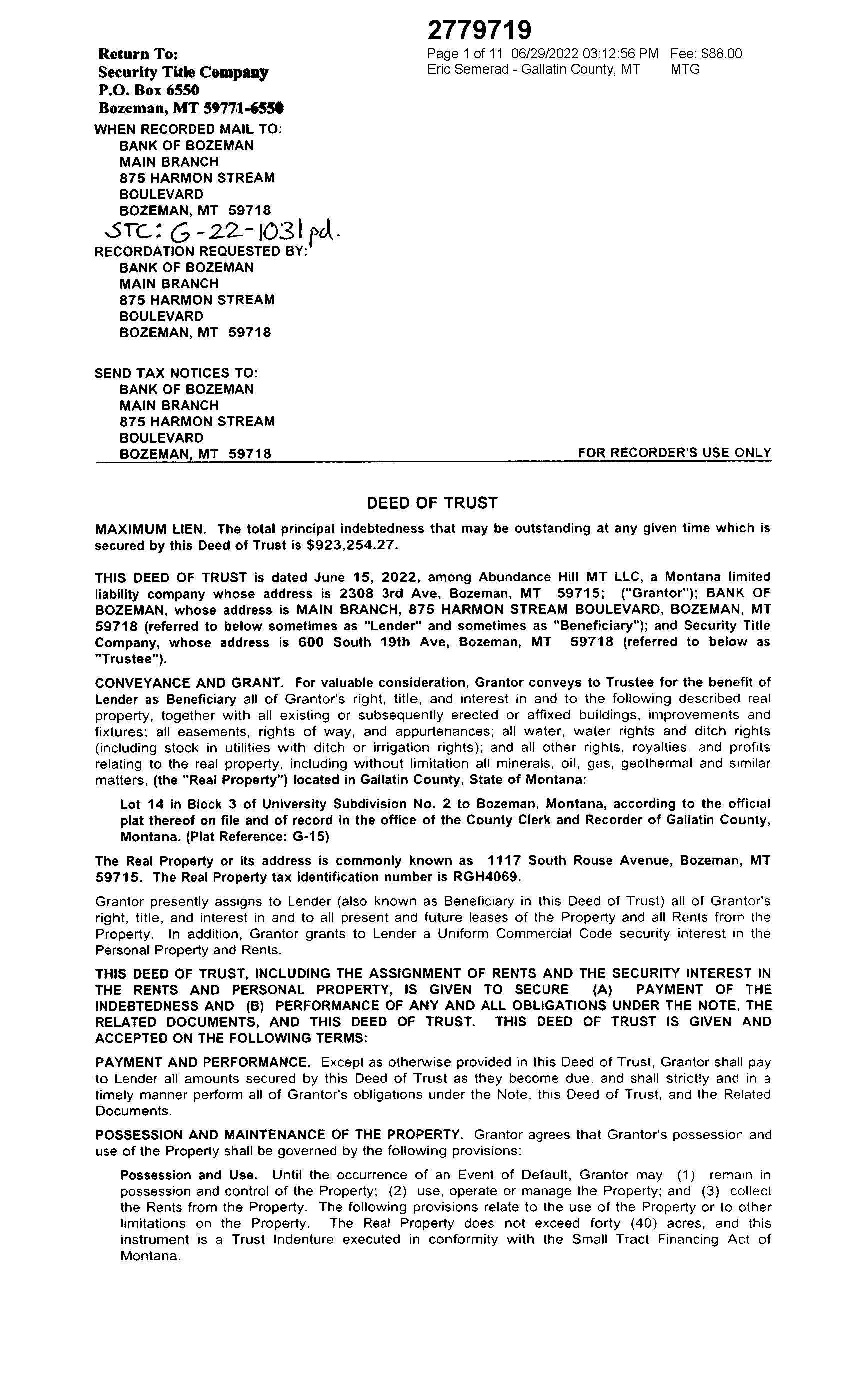
PropertyAddress: 1117 S RouseAve Bozeman 59715
Parcel Number: 06079918235010000
Warmest Regards, TheTitleOneTeam
TitleOne Corporation

wwwTitleOneCorp com
Disclaimer
Any property information contained in this email is subject to the following:This report is based on a search of our tract indexes of the county records This is not a title or ownership report and no examination of the title to the property described has been made For this reason, no liability beyond the amount paid for this report is assumed hereunder, and the company is not responsible beyond the amount paid for any errors and omissions contained herein
Parcel Information
Assessor Number: 000RGH4069
Parcel: 06079918235010000
SiteAddress: 1117 S RouseAve
Bozeman MT59715 - 5384
Owner: Abundance Hill Mt LLC
OwnerAddress: 2308 S 3rdAve
Bozeman MT59715 - 6010
Township/Range/Section: 02S / 06E / 18
Tax Information

Levy Code: 035008
2022 Levy Rate: 622 9700
TaxYear AnnualTax
2022 $4,139 01
2021 $3,773 79
2020 $3,506 95
Parcel Size: 0 1840Acres (8,015 SqFt)
Plat/Subdivision: University Sub 2
CensusTract/Block: 001002 / 1003
Lot / Block: 14 / 3
Waterfront:
AssessmentYear: 2022
Total Land Value: $141,392 00
Total Impr Value: $350,708 00
Total Value: $492,100 00
Legal Land
Gallatin County Parcel Information Land
Zoning:
School District: Bozeman
Improvement
UNIVERSITYSUB 2, S18,T02 S, R06 E, BLOCK 3, Lot 14, PLAT G-15
Neighborhood: 206 102
Watershed: Upper East Gallatin River
Recreation Name: RecreationType: Year Built: 1975 Bedrooms: Stories:
Bathrooms: Full Baths: Half Baths:
BuildType: Heat Source: HeatType: 2 - Hot Water or Steam
TotalArea: Fin SqFt: Roof Covering:
Use: APT U -Apartment Urban Land Use Std: 106 /Apartment
High
R-4-BZ - Residential
Density District
Basement Fin/Unfin: Floor 1: Roof Style: Garage: Floor 2: Deck SqFt: Porch SqFt: Carport SqFt: Foundation: Condition: Ext Walls: Frame
Transfer Information
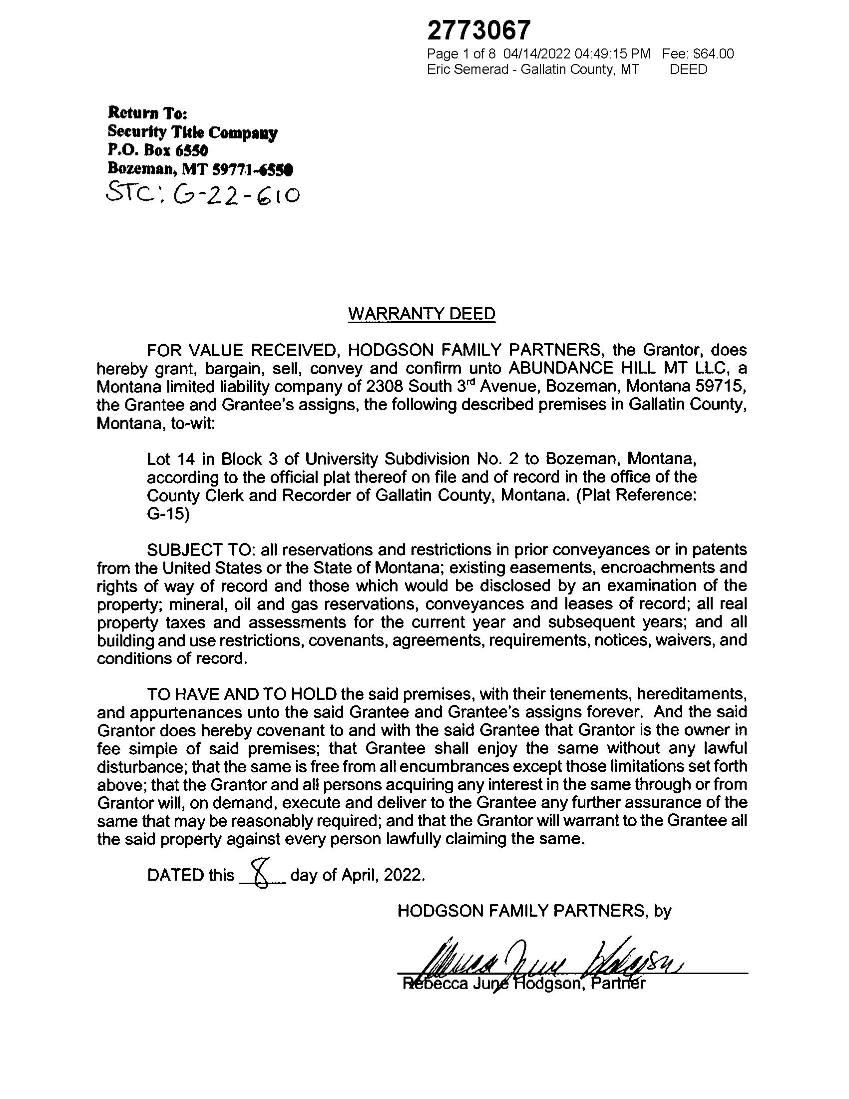
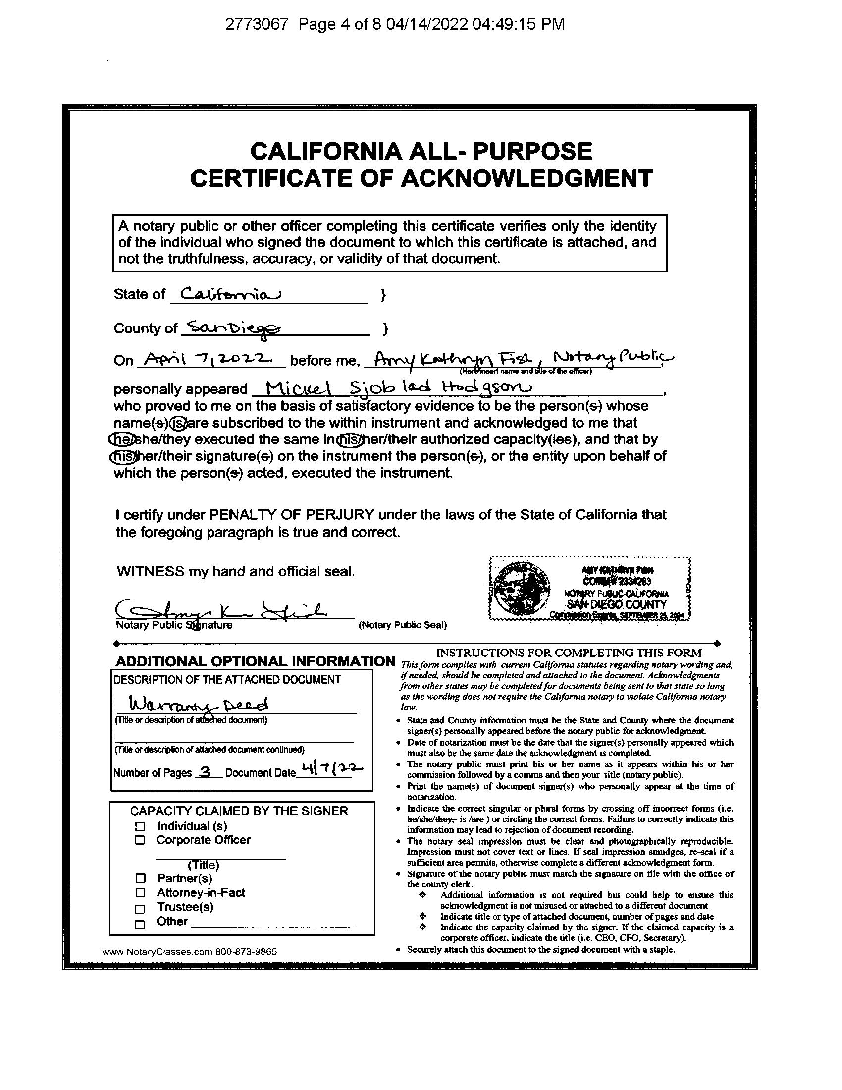
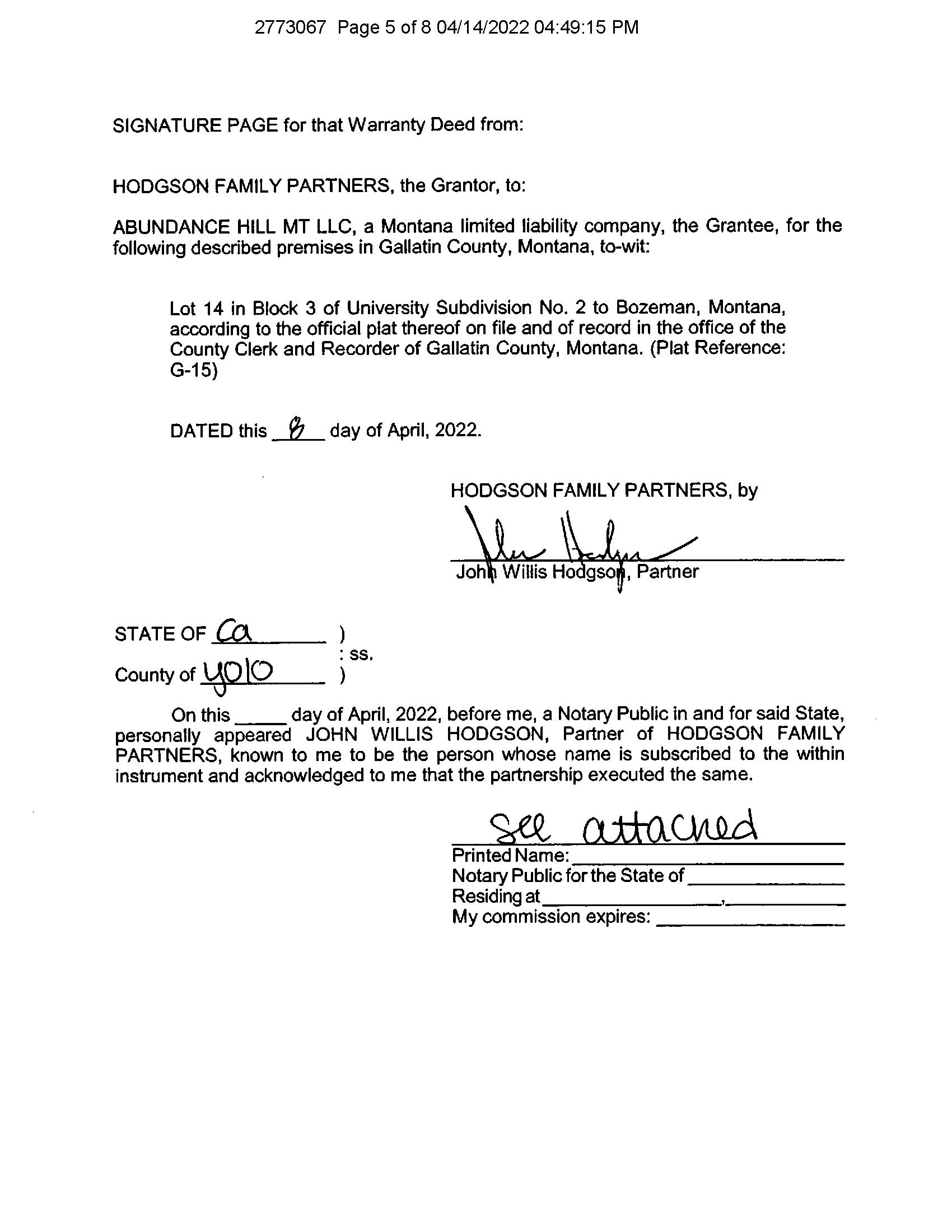
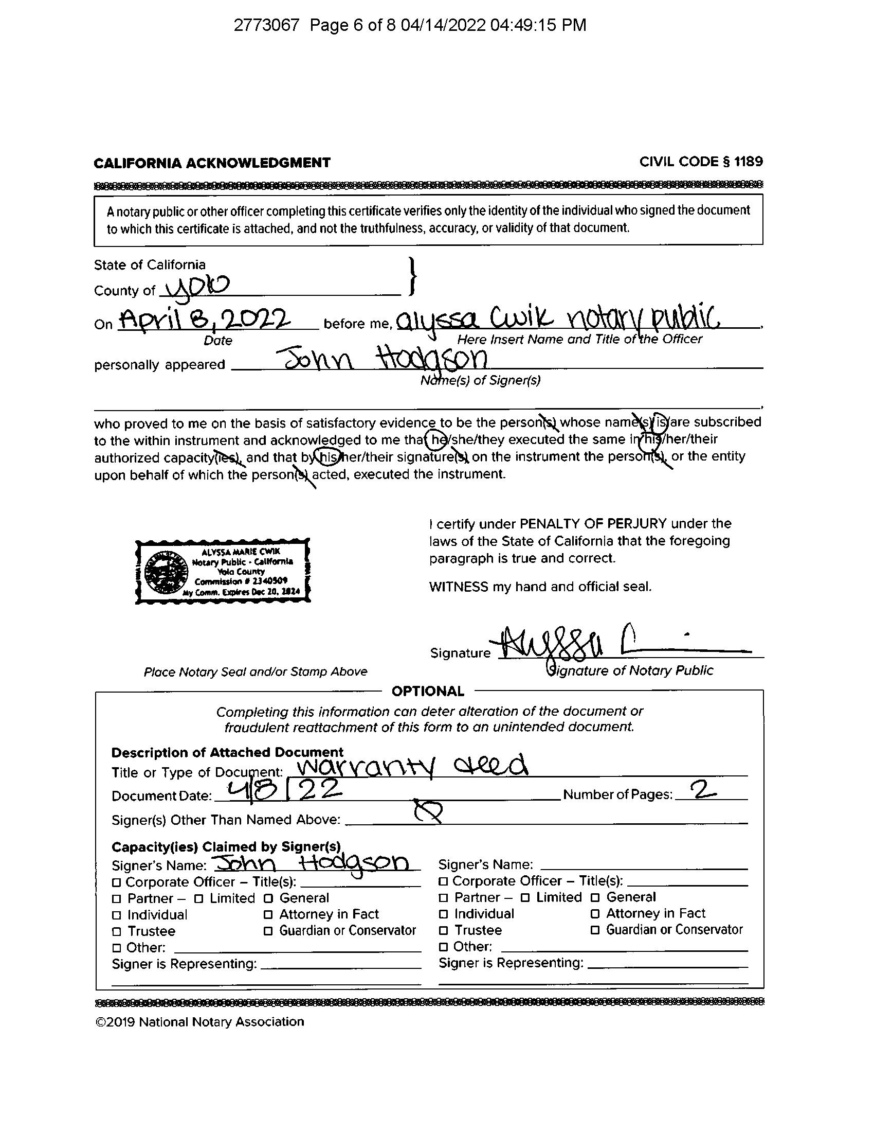
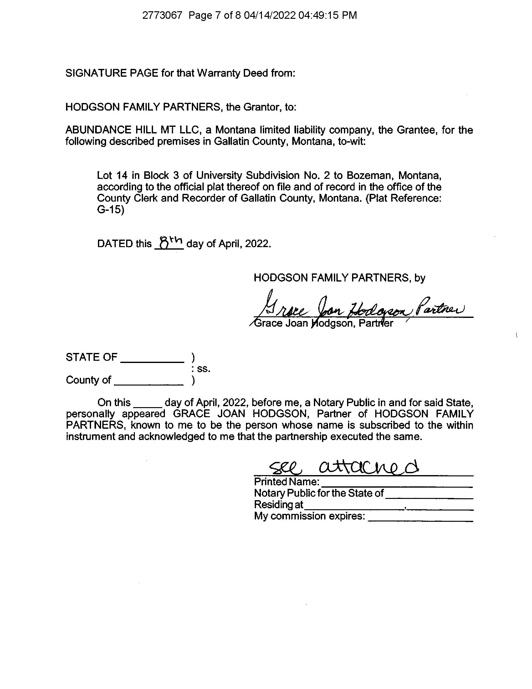
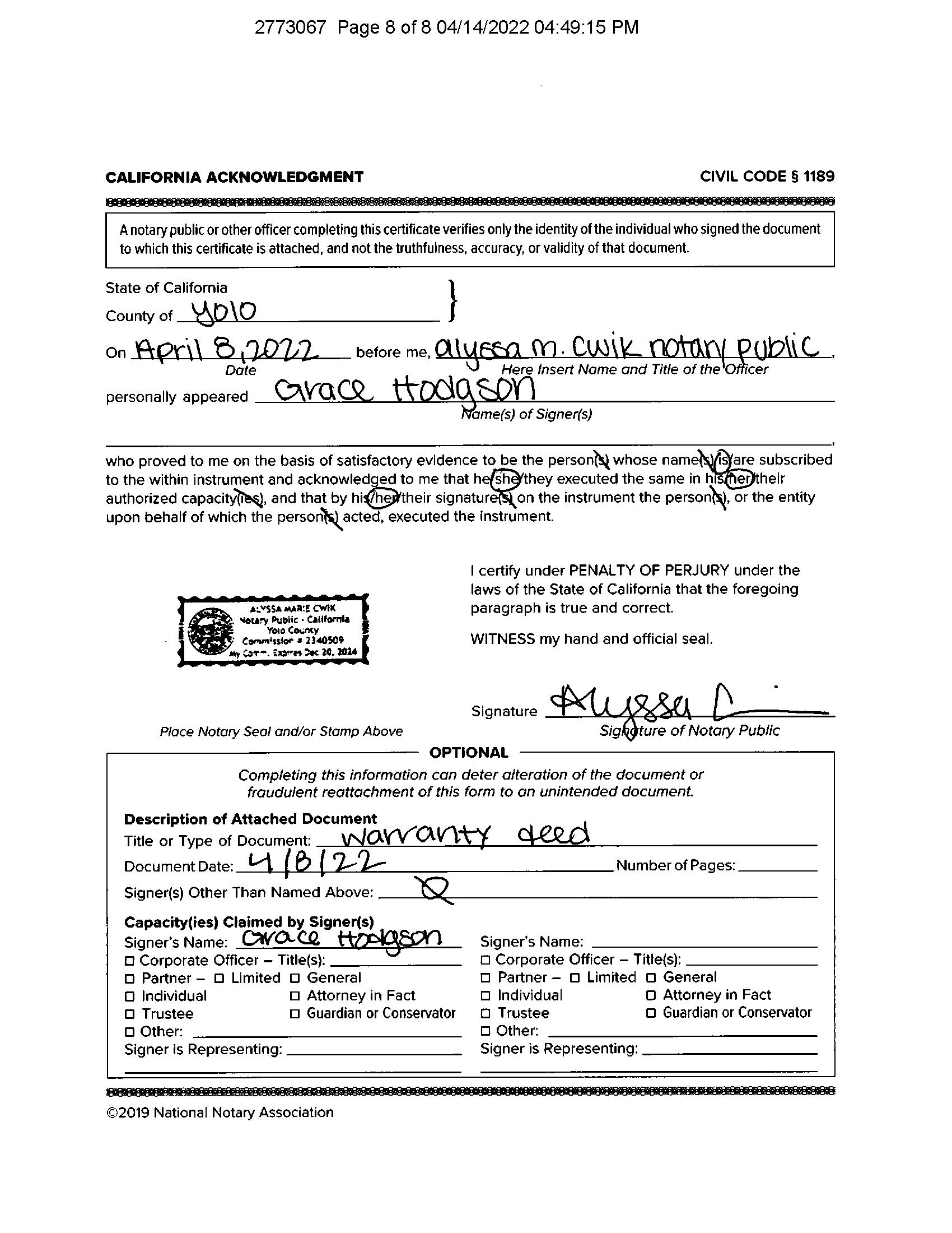
Rec Date:04/14/2022
Owner:Abundance Hill Mt LLC
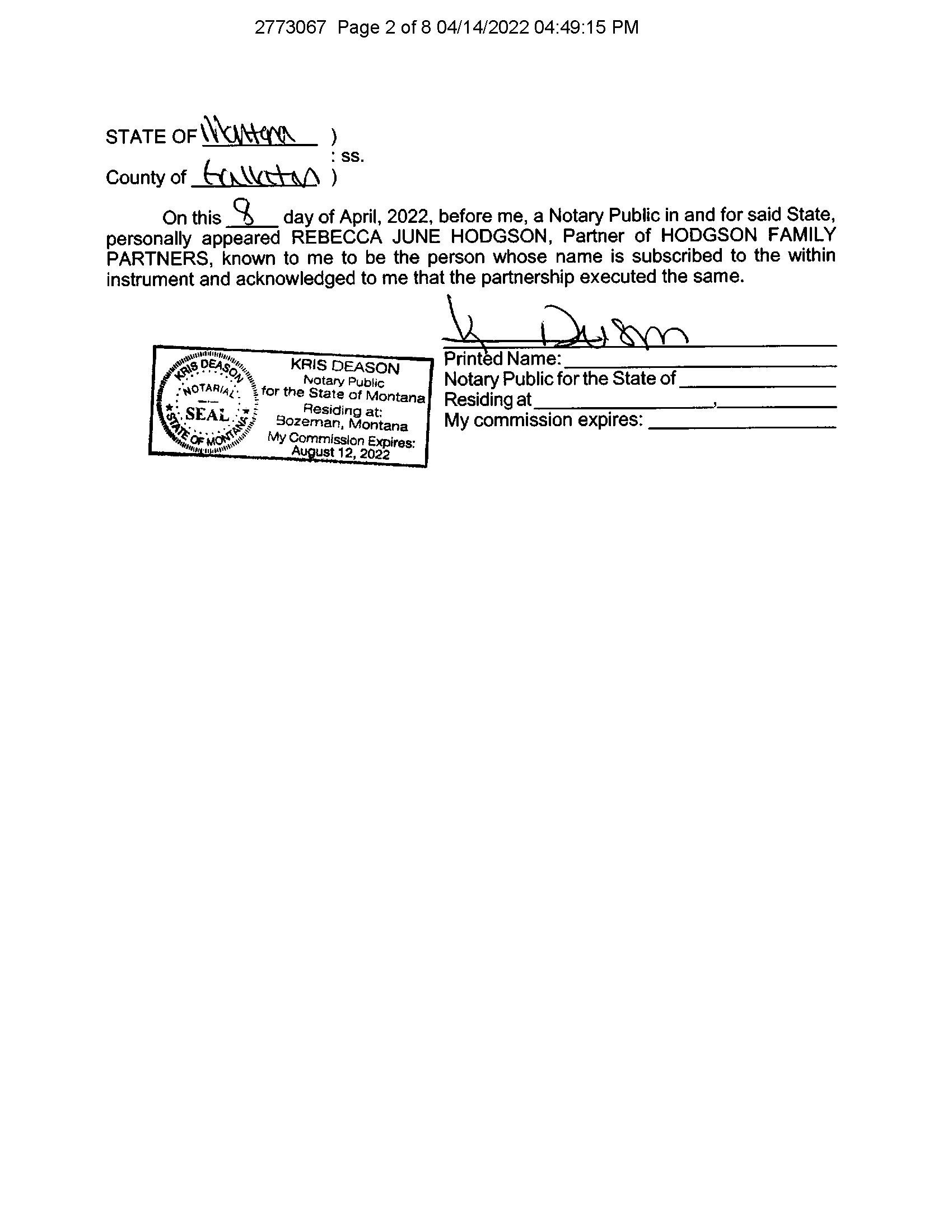
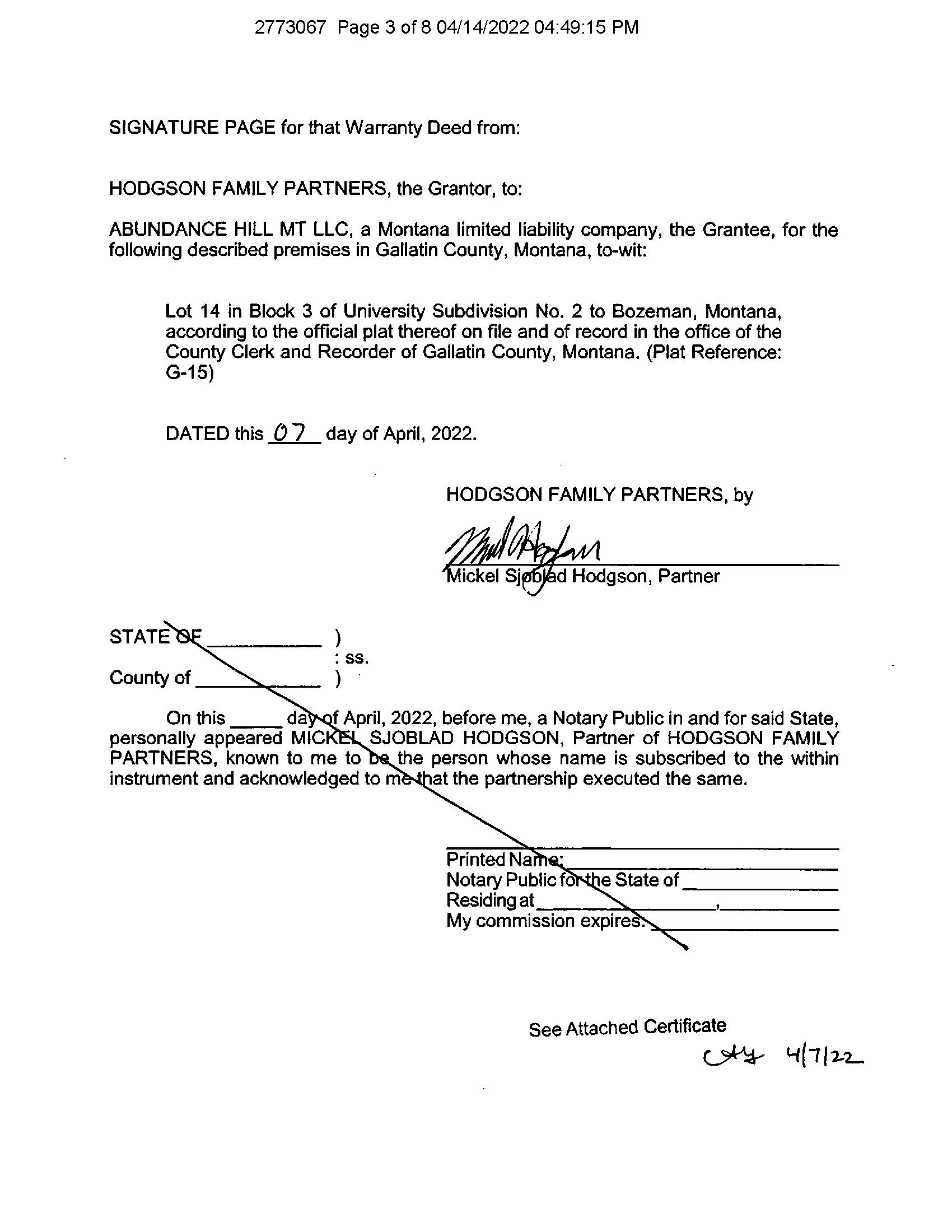
Doc Num:2773067
DocType:Deed
Grantor:HODGSON FAMILYPARTNERS
Orig. LoanAmt: Title Co:SECURITYTITLE CO
FinanceType: LoanType: Lender:
Sentry Dynamics, Inc and its customers make no representations, warranties or conditions, express or implied, as to the accuracy or completeness of information contained in this report
Shopping Cart: 0 items [$0 00]
Property/Parcel TaxID: RGH4069 Status: Current


Mailing Address: 2308 S 3RD AVE BOZEMAN, MT 597156010


Receipt: 4069
2022 Owner(s): ABUNDANCE HILL MT LLC


Levy District: 0350-08, 7C BOZEMAN(C)BZP 2022 Value:
2022 Payments:


First Half: $2,171.19 Second Half: $0 00
$2,171 19 (May include penalty & interest)
2022 Legal Records:


Property address: 1117 S ROUSE AVE, BOZEMAN MT 59715
Subdivision: (UN2) University Subdivision # 2 Lot: 14 Block: 3 TRS: T02 S, R06 E, Sec. 18
Legal: UNIVERSITY SUB 2, S18, T02 S, R06 E, BLOCK 3, Lot 14, PLAT G-15
Acres: 0 18
Market:
Taxable: $6,644 2022 Taxes: First Half: $2,076.19 Due: 12/9/2022 Second Half: $2,076 19 Due: 5/31/2023 Total: $4,152 38
$492,100
Total:
Geo Code: 06-0799-18-2-35-01-0000 Instru#: 2773067 Date: 2022-04-14
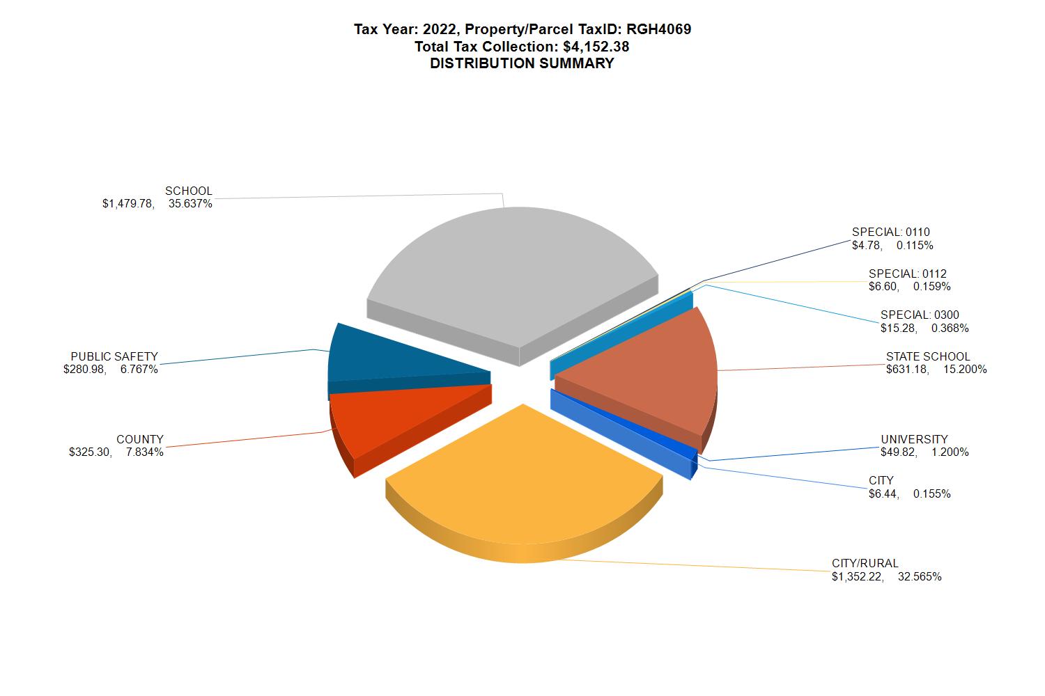
Shopping Cart: 0 items [$0 00] Tax Year: 2022 Property/Parcel TaxID: RGH4069 Status: Current Type: RE Owner: ABUNDANCE HILL MT LLC 2022 Tax Breakdown: Stat# Kind Description 1st Half 2nd Half 4069 CITY CITY TAXES $3.22 $3.22 4069 CITY/RURAL CITY/RURAL TAXES $676 11 $676 11 4069 COUNTY COUNTY TAXES $162 65 $162 65 4069 PUBLIC SAFETY PUBLIC SAFETY $140.49 $140.49 4069 SCHOOL LOCAL SCHOOL TAXES $739 89 $739 89 4069 SPECIAL: 0110 GLTN CONSV DIST MILLS $2 39 $2 39 4069 SPECIAL: 0112 GLTN CO WTR QUALITY (FEE) $3 30 $3 30 4069 SPECIAL: 0300 OPEN SPACE BOND MILLS $7 64 $7 64 4069 STATE SCHOOL STATE SCHOOL TAXES $315 59 $315 59 4069 UNIVERSITY UNIVERSITY/COLLEGE $24 91 $24 91 1st Half Total: $2,076 19 2nd Half Total: $2,076 19 Total Tax: $4,152 38
Shopping Cart: 0 items [$0 00]
Property/Parcel TaxID: RGH4069
Status: Current
Type: RE
Owner: ABUNDANCE HILL MT LLC
** Paid Amount may include penalty & interest
History: Tax Year Statement# Bill Date Bill Amount Date Paid ** Paid Amount Notes 2022 4069 10/24/2022 $4,152.38 4/14/2023 $2,171 19 $0 00 2021 4069 10/27/2021 $3,811.88 12/15/2021 4/19/2022 $1,905.95 $1,905 93 2020 46319 11/05/2020 $3,541 24 11/20/2020 5/12/2021 $1,770.63 $1,770 61 2019 4069 10/30/2019 $3,621 87 11/6/2019 5/15/2020 $1,810 94 $1,810.93 2018 4069 10/31/2018 $3,229 90 11/28/2018 5/15/2019 $1,618 26 $1,611.64 2017 4069 10/31/2017 $3,019.73 11/14/2017 5/10/2018 $1,513 17 $1,506 56 2016 4069 11/16/2016 $3,058 25 12/21/2016 4/13/2017 $1,532.43 $1,525 82
Property Record Card
Summary
Primary Information
Property Category:RP
Geocode:06-0799-18-2-35-01-0000
Subcategory:Commercial Property
Assessment Code:000RGH4069
Primary Owner: PropertyAddress:1117 S ROUSEAVE
ABUNDANCE HILLMTLLC BOZEMAN, MT59715
2308 S 3RDAVE COS Parcel:
BOZEMAN, MT59715-6010
NOTE: See the Owner tab for all owner information
Certificate of Survey:
Subdivision:UNIVERSITYSUB 2
Legal Description:
UNIVERSITYSUB 2, S18,T02 S, R06 E, BLOCK 3, Lot 14, PLATG-15
Last Modified:5/6/2023 9:45:22AM
General Property Information
Neighborhood:206 102 Property Type:APT U -Apartment Urban
Living Units:4 Levy District:06-035008-7C 08
Zoning: Ownership %:100
Linked Property: No linked properties exist for this property
Exemptions: No exemptions exist for this property
Condo Ownership:
General:0
Limited:0
Topography: Fronting: Utilities: Parking Type: Access: Parking Quantity: Location: Parking Proximity: Land Summary Land Type Acres Value Grazing 0 000 00 00 Fallow 0 000 00 00 Irrigated 0 000 00 00 Continuous Crop 0 000 00 00 Wild Hay 0 000 00 00 Farmsite 0 000 00 00 ROW 0 000 00 00 NonQual Land 0 000 00 00 TotalAg Land 0 000 00 00 Total Forest Land 0 000 00 00 Total Market Land 0 184 00 00 Deed Information: Deed Date Book Page Recorded Date Document Number Document Type 4/14/2022 4/14/2022 2773067 Warranty Deed 4/2/2003 2102 964D 2/14/2002 2060 915D
Property Factors
Owners
Party #1
Default Information: ABUNDANCE HILLMTLLC 2308 S 3RDAVE
Ownership %: 100
Primary Owner: "Yes"
Interest Type: Fee Simple
Last Modified: 5/12/2022 9:14:37AM
Other Names
Appraisals
Market Land
Market Land Item #1
Method:Sqft Type:Primary Site
Width: Depth: Square Feet:8,000 Acres:
Valuation
Class Code:2227
Dwellings
Existing Dwellings
No dwellings exist for this parcel
Other Buildings/Improvements
Outbuilding/Yard Improvement #1
Value:
OtherAddresses
Type:Commercial Description:CPA1 - Paving, asphalt
Quantity:1 Year Built:1975
Condition: Functional:3-Normal
Dimensions
Width/Diameter:40 Length:80
Height: Bushels:
Commercial
Existing Commercial Buildings
Grade:A
Class Code:3527
Size/Area:
Circumference:
12/26/2001 2056 455D 8/19/1996 166 71D 8/19/1996 166 73D 8/15/1996 165 4096D
Name Type
Appraisal History TaxYear Land Value Building Value Total Value Method 2022 141392 350708 492100 INCOME 2021 141392 350708 492100 INCOME
Number Building Name Structure Type Units/Bldg YearBuilt
Building
General Building Information
Building Number:1 Building Name: Structure Type:104 - Residential, 4-family
Units/Building:4 Identical Units:1
Grade:A Year Built:1975 Year Remodeled:0
Class Code:3527 EffectiveYear:1995 Percent Complete:0
Interior/Exterior Data Section #1
Level From:02 Level To:02 Use Type:011 -Apartment
Dimensions
Area:1,539 Use SKArea:1
Perimeter:165 Wall Height:8
Features
Exterior Wall Desc:02 -
Frame Construction:1-Wood Frame/Joist/Beam
% Interior Finished:100 Partitions:2-Normal
AC Type:0-None Plumbing:2-Normal
Physical Condition:3Normal Functional Utility:3-Normal
Building Other Features
No other features exist for this interior/exterior detail
Interior/Exterior Data Section #2
Economic Life:50
Heat Type:2-Hot Water or Steam
Level From:01 Level To:01 Use Type:011 -Apartment
Dimensions
Area:1,539 Use SKArea:1
Perimeter:165 Wall Height:9
Features
Exterior Wall Desc:02Frame Construction:1-Wood Frame/Joist/Beam
% Interior Finished:100 Partitions:2-Normal
AC Type:0-None Plumbing:2-Normal
Physical Condition:3Normal Functional Utility:3-Normal Building Other Features
Elevators and Escalators
No elevators or escalators exist for this building
Ag/Forest Land
Ag/Forest Land
No ag/forest land exists for this parcel
Economic Life:50
Heat Type:2-Hot Water or Steam
1 104 - Residential, 4-family 4 1975 View
Description Qty Width Length Height Area Calculated Value Unadjusted Value PP1 - Porch, open 2 00 00 0 36 0 0
Click2Gov Assessment Billing - Account Inquiry
Account ID: 520
Owner Name: ABUNDANCE HILL MT LLC
Location ID: 520
Address: 1117 S ROUSE AVE, BOZEMAN, MT 59715
County Parcel # RGH4069
General Account Information
Assessment Information for 2023
Billed Assessments: $579.48
Current Assessments Due : $0.00
Interest, Penalties, and Collections: $0.00
Total Due: $0.00
Only the "Total Due:" amount may be paid at this time. "LOG IN" is not required.
Parcel ID: 06079918235010000
Sentry Dynamics, Inc and its customers make no representations, warranties or conditions, express or implied, as to the accuracy or completeness of information contained in this report.
Street Map
Parcel ID: 06079918235010000
Sentry Dynamics, Inc and its customers make no representations, warranties or conditions, express or implied, as to the accuracy or completeness of information contained in this report.
Aerial Map
