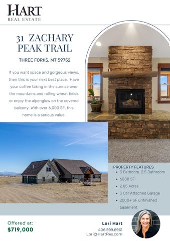
31 ZACHARY PEAK TRAIL THREE FORKS, MT 59752 If you want space and gorgeous views, then this is your next best place. Have your coffee taking in the sunrise over the mountains and rolling wheat fields or enjoy the alpenglow on the covered balcony. With over 6,000 SF, this home is a serious value.
PROPERTY FEATURES 3 Bedroom, 2.5 Bathroom 6088 SF 2.05 Acres 3 Car Attached Garage 2000+ SF unfinished basement
Offered at:
Lori Hart
$719,000
406.599.6961 Lori@HartRes.com
Breathtaking Views! Loaded with windows, this spacious home captures the best of the area. With mostly main floor living, thoughtful lighting, and 2acre lot, attain that Montana Dream. The owner's suite is ideally located in its own wing, with two bedrooms and second bath in the other wing. A separate office will accommodate remote work. Upstairs, a bonus room could easily be converted to a guest suite or serve as an ideal playroom. Create the ultimate rec room, guest quarters or multigenerational set up in the 2000+SF unfinished walkout basement.
3/29/22, 4:42 PM
Montana's Ground-Water Information Center (GWIC) | Site Report | V.11.2022
MONTANA WELL LOG REPORT
Other Options
This well log reports the activities of a licensed Montana well driller, serves as the official Return to menu record of work done within the borehole and casing, and describes the amount of water Plot this site in State Library Digital Atlas encountered. This report is compiled electronically from the contents of the Ground Water Plot this site in Google Maps Information Center (GWIC) database for this site. Acquiring water rights is the well owner's responsibility and is NOT accomplished by the filing of this report. Site Name: COLTON HOMES GWIC Id: 234902
Section 7: Well Test Data Total Depth: 200 Static Water Level: 102 Water Temperature:
Section 1: Well Owner(s) 1) LEAHY, JEFF (MAIL) 51 EAST ALEX COURT BOZEMAN MT 59718 [03/19/2007]
Air Test *
Section 2: Location Township 02N
Range 01E County
Section 6
Quarter Sections SE¼ SW¼ Geocode
BROADWATER Latitude Longitude Geomethod 45.949013 -111.651601 TRS-TWN Ground Surface Altitude Ground Surface Method
40 gpm with drill stem set at 180 feet for 1 hours. Time of recovery 2 hours. Recovery water level 102 feet. Pumping water level feet.
Datum * During the well test the discharge rate shall be as uniform as NAD27 possible. This rate may or may not be the sustainable yield of the Datum Date well. Sustainable yield does not include the reservoir of the well
casing. Addition MOUNTAIN VISTA ESTATES
Block
Lot 5
Section 3: Proposed Use of Water
Section 8: Remarks Section 9: Well Log Geologic Source Unassigned
DOMESTIC (1)
Section 4: Type of Work
From To
Drilling Method: ROTARY Status: NEW WELL
0
Description 12 SANDY BROWN CLAY
12
45 SAND AND BROWN CLAY
Section 5: Well Completion Date
45
61 BROWN MUDSTONE
Date well completed: Monday, March 19, 2007
61 91
Section 6: Well Construction Details
113
117 LIGHT BROWN SILTSTONE
117
122 GREY SANDSTONE
122
134 CEMENT COARSE SAND AND GREY CLAY
134
137 GRET AND GREEN SILSTONE
137
151 CEMENTED COARSE WHITE SAND
151
162 CEMENTED COARSE SAND AND PEA GRAVELS
WELDED A53B STEEL
162
175
SPLINE
175
200 GREEN AND GREY SANDSTONE
Borehole dimensions From To Diameter 0 200
6
Casing From To
Wall Pressure Diameter Thickness Rating Joint
1.5
78.5 6
60
160 4
0.25 220.0
Type PVC-SCHED 40
Completion (Perf/Screen) # of Size of From To Diameter Openings Openings Description 160
200 4
400
.250
Annular Space (Seal/Grout/Packer) Cont. From To Description Fed? 0
20 BENTONITE Y
91 GREY SANDY SHALE 113 SANDY GREY MUDSTONE
FACTORY SLOTTED
GREY, GREEN SANDSTONE AND COARSE WHITE SAND STRINGERS
Driller Certification All work performed and reported in this well log is in compliance with the Montana well construction standards. This report is true to the best of my knowledge. Name: CURT SAMPSON Company: BRIDGER DRILLING INC License No: WWC-560 Date Completed: 3/19/2007
https://mbmggwic.mtech.edu/sqlserver/v11/reports/SiteSummary.asp?gwicid=234902&agency=mbmg&session=1147096&
1/1