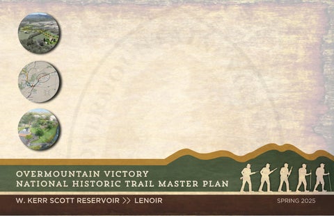
Overmountain Victory National Historic Trail Master Plan - Kerr Scott to Lenoir
"NATIONAL HISTORIC TRAILS ARE A UNIQUE COOPERATIVE EFFORT BETWEEN LOCAL JURISDICTIONS, THE NATIONAL PARK SERVICE, AND NON-PROFIT PARTNERS TO BRING THE EXPERIENCE OF THE OVERMOUNTAIN VICTORY TRAIL TO LIFE."
Jeffrey J. Ellison, Trail Administrator, Overmountain Victory National Historic Trail
PROJECT OVERSIGHT COMMITTEE
Bryant Lindsey, President, Overmountain Victory North Carolina State Trail – Friends
Linda Lindsey, Board Member, Overmountain Victory North Carolina State Trail – Friends
Starli Phillips McDowell, Former Executive Director, Overmountain Victory North Carolina State Trail –Friends
Col. Brian T. Oliver, USMCR (retired), Executive Director, Overmountain Victory North Carolina State Trail –Friends
Smith Raynor, State Trails Planner, NC State Parks
Thomas Nicholson, Operations Project Manager, US Army Corp of Engineers - W. Kerr Scott Dam and Reservoir
David Bolick, Natural Resource Specialist, US Army Corp of Engineers - W. Kerr Scott Dam and Reservoir
Melissa Patton, Executive Director, Carolina Land and Lakes Resource Conservation and Development
Jonathan Hartsell, Executive Director, Blue Ridge Resource Conservation and Development
Shelley Stevens, Planning Director, Caldwell County
W.C. Scroggs, Planning Director, Wilkes County
Hannah Williams, Planning Director, City of Lenoir
Matthew Duchan, Planner/GIS Specialist, City of Lenoir
R.G. Absher, Board Member/Executive Director, Overmountain Victory Trail Association/Yadkin River Greenway Council
Dylan Powell, Planner, Town of Wilkesboro
Tom Kenney, Land Protection Director, Foothills Conservancy of North Carolina
Charlie White, Board President, Yadkin River Greenway Council
OVERMOUNTAIN VICTORY NORTH CAROLINA STATE TRAIL – FRIENDS
Dr. Bryant Lindsey, President
Dr. David Burleson, Vice President
Joshua Harris, Treasurer
Dr. Linda Lindsey, Board Member
Col. Brian T. Oliver, USMCR (Retired), Executive Director
Dr. Daniel Barron, Former Board Member
OVERMOUNTAIN VICTORY TRAIL ASSOCIATION
David Doan, President
R.G. Absher, Vice President
Mark Anthony, Secretary
Tom Vaughn, Treasurer
Chivous Bradley, Board Member
Cam Chidiac, Board Member
John Garrou, Board Member
Dan Hopping, Board Member
Garrett Jackson, Board Member
LeighAnn Moon, Board Member
Taylor Osborne, Board Member
Gordon Sisk, Board Member
Tony Devault, Board Member
John Gullion, Board Member
Leigh Anne Hunter, Board Member
Brad Knight, Board Member
Bryant Lindsey, Board Member
Mel McKay, Board Member
Dalton Wade, Board Member
WILKES COUNTY, NC
John Yates, County Manager
Shirley Randleman, Chairman
Bill Sexton, Vice Chairman
Casey Joe Johnson, Commissioner
CALDWELL COUNTY,
NC
Donald E. Duncan Jr., County Manager
Jimmy Harrison, Deputy County Manager
Randy T. Church, Chairman
Mike LaBrose, Vice Chairman
CITY OF LENOIR, NC
Scott Hildebran, City Manager
Joe Gibbons, Mayor
David Stevens, Mayor Pro Tem
Jonathan Beal, Council Member
Todd Perdue, Council Member
Evan Handy, Commissioner
Hardin Kennedy, Commissioner
Jeff Branch, Commissioner
Donnie Potter, Commissioner
Patrick Starnes, Commissioner
James "Ike" Perkins, Council Member
Ralph Prestwood, Council Member
Kimmie Rogers, Council Member
Crissy Thomas, Council Member
INTRODUCTION
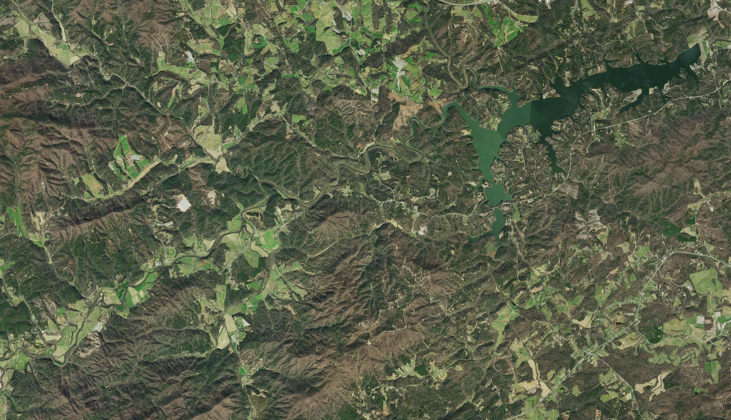
The Overmountain Victory Trail is approximately 330 miles in length and is located in portions of Virginia, Tennessee, North Carolina, and South Carolina. The trail commemorates the significance of the patriot militia that marched from the Appalachian mountains and their foothills to defeat the British-led loyalist army at the battle of Kings Mountain on October 7, 1780.
This trail master plan serves as a road map for establishing a section of the Overmountain Victory National Historic Trail (OVNHT) and North Carolina State Trail (OVST) from W. Kerr Scott Reservoir in Wilkes County, NC to Lenoir, NC.
BACKGROUND
This project is part of ongoing efforts to develop regional trail master plans in order to strengthen multi-jurisdictional partnerships and engage landowners to expand and connect the growing network of certified OVNHT segments throughout Virginia, Tennessee, and North and South Carolina.
In 2024, the Overmountain Victory North Carolina State Trail - Friends (OVNCST-Friends) funded a comprehensive master plan for the Overmountain Victory Trail (OVT) from W. Kerr Scott Reservoir to Lenoir, North Carolina. Their organization supports the communities along this historic trail by leveraging it to advance local community goals, including education, economic development, historic preservation, public health, and environmental stewardship. A number of project stakeholders participated in the planning process, including Federal, State, and local government staff and non-profit organizations.
It is expected that trails developed along recommended routes within the plan study area will be eligible for inclusion by the National Park Service as part of the official certified Overmountain Victory National Historic Trail non-motorized route and by North Carolina State Parks as part of the official designated North Carolina State Trail.
STATE TRAIL AUTHORIZATION
In June of 2019, NC Governor Roy Cooper signed S.L. 2019-20 into law, authorizing the Overmountain Victory Trail as a State Trail within the NC State Parks system. The OVST will be co-located with the OVNHT throughout North Carolina. The North Carolina Trails System Act (GS 143B- 135.90) defines a State Trail as a linear corridor on land or water, separated from vehicular traffic, providing public access for non-motorized recreation or transportation. All state trails must be located in a permanently protected corridor.
While a State Park is operated and managed by the NC Division of Parks and Recreation (NCDPR), a State Trail is comprised of multiple trail sections that are sponsored by state or federal agencies, local governments, non-profit organizations, and private landowners. NCDPR provides guidance, coordination, and assistance for the section sponsors. The sponsors build, maintain, and manage their section of the trail, deciding on location, design, surface, permitted uses, and amenities.
OVERMOUNTAIN VICTORY NORTH CAROLINA STATE TRAIL – FRIENDS
In 2021, legislation passed by the North Carolina General Assembly created the Complete the Trail Program (CTP) and provided an unprecedented level of funding for the planning, construction, promotion, and maintenance of state trails in North Carolina. This legislation requires that each state trail has a recognized nonprofit or local government partner with a Memorandum of Understanding and an approved plan to use these funds to develop the state trail. The OVNCSTFriends was established to support efforts for development of the Overmountain Victory State Trail in North Carolina.
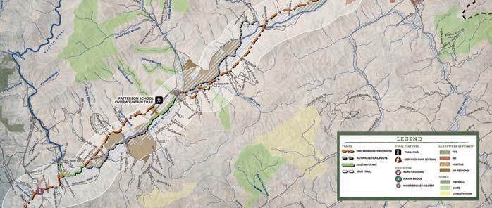
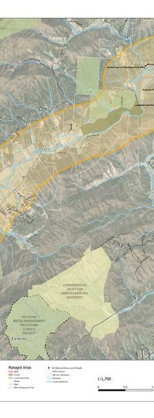
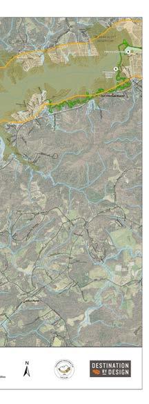
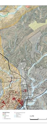
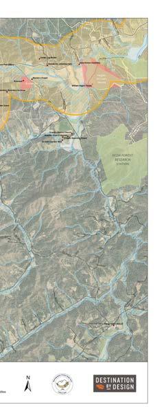
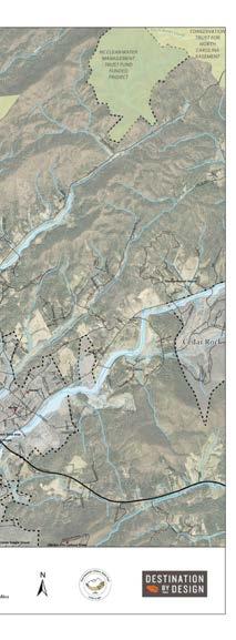
MAP 1: OVT PLANNING AREAS
THIS PLAN'S STUDY AREA
This plan’s study area examines Section 6 of the OVT and incorporates 28 miles of trail corridor from W. Kerr Scott Reservoir to Lenoir, NC.
COMPLETED MASTER PLANS
This trail plan was developed in the same spirit as eight other OVT Master Plans completed from 2015 to 2021: Abingdon to Elizabethton (Section 1); Spruce Pine to Lake James (Section 3); Lake James to Morganton (Section 4); Elkin to W. Kerr Scott Reservoir (Section 5); Lenoir to Morganton (Section 7); Morganton to Rutherfordton (Section 8); Rutherfordton to Chesnee (Section 9); and Chesnee to Kings Mountain (Section 10). Project partners are working to develop similar plans for all areas included within the congressionally-designated OVNHT corridor.
PLAN GOALS
LANDOWNER OUTREACH IS A CRITICAL COMPONENT OF THE OVT PLANNING PROCESS.
1 3
Specific Trail Routes. Identify a specific and feasible trail route within or near the known historic corridor of the Overmountain Victory Trail as determined by NPS.
4
5 2
Landowner Outreach. Make a direct appeal to landowners identified during the analysis phase and record their sentiments for providing a trail easement.
Visual Plan. Create a visual plan that provides renderings and schematics to demonstrate trail character.
Support Other Community Goals. To the extent possible, identify opportunities to leverage the trail to further other community goals, including economic development, historic preservation, public health, and environmental stewardship.
Social Media. Incorporate modern social media marketing tools within the trail and signage infrastructure to promote the development of “user generated” marketing content.
PLANNING PROCESS
The final plan is published for review by stakeholders, elected officials, and the public. 1. 2. 3. 4. 5.
Direction Setting and Project Launch | December 2023
The consultant team met with local trail and government leaders to generally discuss environmental constraints and opportunities for trail connectivity.
Research | December 2023 - February 2024
The consultant team conducted a thorough site analysis of the study area and determined feasible trail route options. With the trail routes identified, a landowner contact list was developed.
Landowner Outreach | March 2024
Landowners with property along an identified feasible trail route were invited to a special meeting to learn more about the trail project. After receiving comments from landowners, the preferred trail route was revised accordingly.
Plan Development | March - September 2024
The consultant team worked in tandem with local leaders to develop a preferred trail alignment. Renderings and schematics were provided to visually support the trail recommendations.
Final Plan Preparation | October - December 2024
project timeline
DEC.‘23DEC.‘23-FEB.‘24MAR.‘24MAR.-SEPT.’24
PLAN ORGANIZATION
Chapter I.
Existing Conditions, Analysis, and Preliminary Alignments
This chapter provides a comprehensive overview and analysis of the opportunities and constraints found throughout the study area. The analysis begins with a brief description of the study area followed by a comprehensive discussion of the natural and built environments and their implications for trail suitability, permitting, and costs. This chapter concludes with a map and photographic series that highlights preliminary trail route alternatives.
IV.
Recommendations
Chapter II.
Landowner and Public Engagement
Significant efforts were made to reach out to landowners where the preliminary analysis (results from Chapter I) indicate that the trail is most suitable. This chapter outlines the process and results of landowner outreach, including a map series illustrating landowner sentiment.
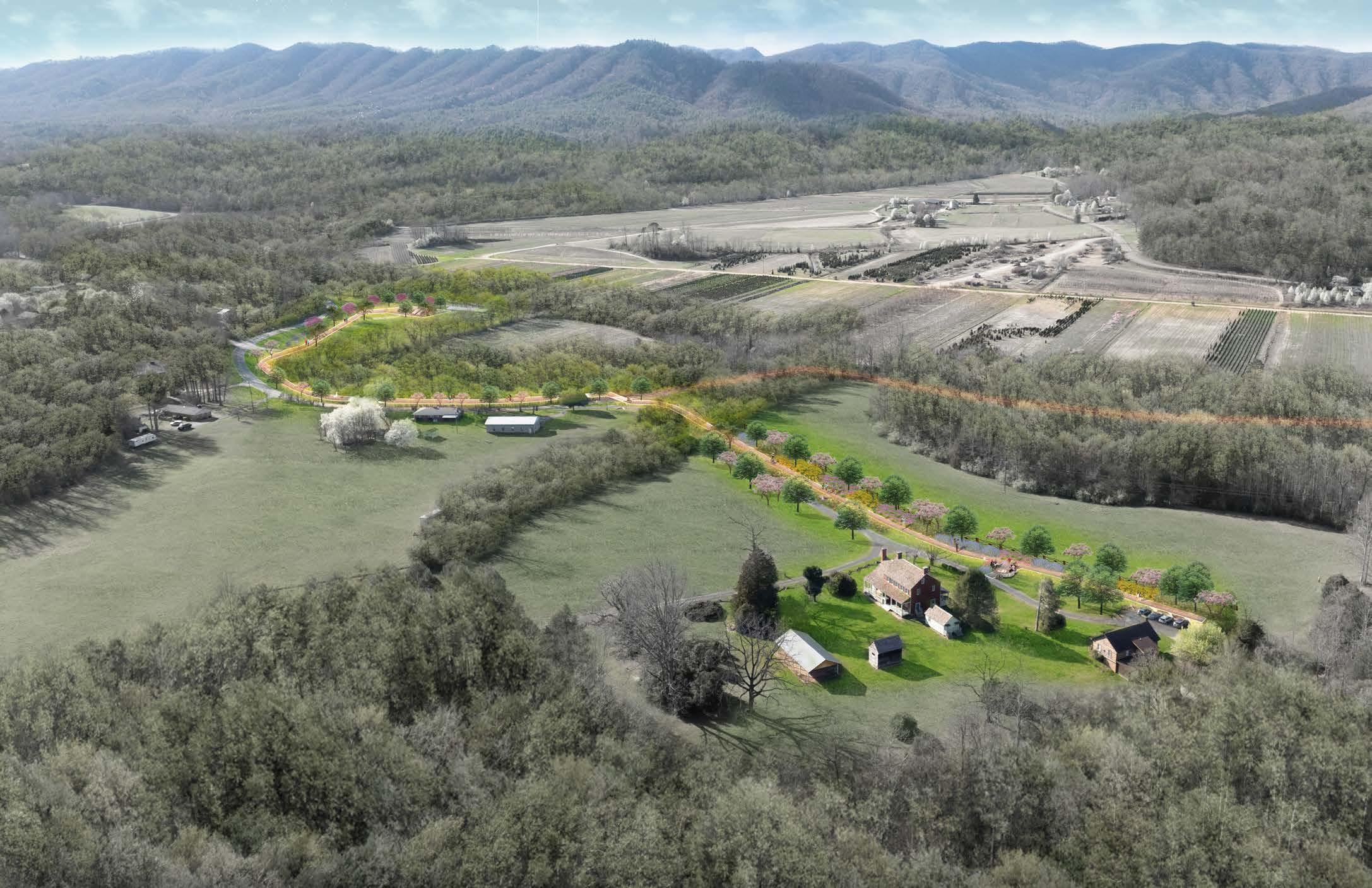
The fourth chapter breaks the study area into three (3) planning sections. Each planning section includes a map that displays a preferred alignment. Each planning section further incorporates the analysis and design elements from the previous chapters along with supporting renderings and design schematics.
Chapter III.
Trail Character & Design Guidelines
3 -
This chapter is dedicated to visually defining the various trail types to be used throughout the corridor. Also, design concepts are provided for all types of trail user orientation signage, mile markers, historic markers, and other trail support facilities.
V.
This chapter provides a summary of implementation priorities organized by planning section and focus area. Implementation
Chapter
Chapter
CHAPTER 1
EXISTING CONDITIONS, ANALYSIS, AND PRELIMINARY ALIGNMENTS
This chapter features an overview and analysis of the opportunities and constraints found throughout the study area.
The analysis begins with a brief description of the study area followed by a comprehensive discussion of the natural and built environments and their implications for trail suitability, trail design features, permitting, and costs. This chapter concludes with a map and photographic series that highlights preliminary trail route alternatives.
IN THIS CHAPTER
A. Study Area Description
B. Natural Environment Analysis
C. Built Environment Analysis
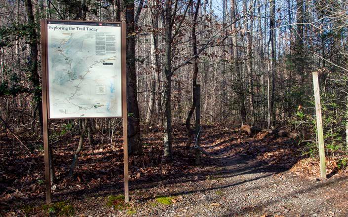
D. Map and Photo Series: Preliminary Trail Route Alternatives
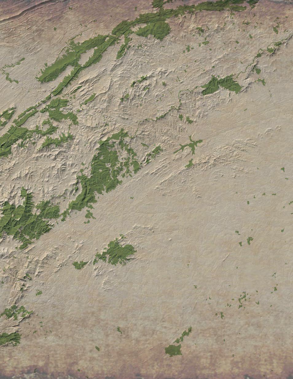
STUDY AREA
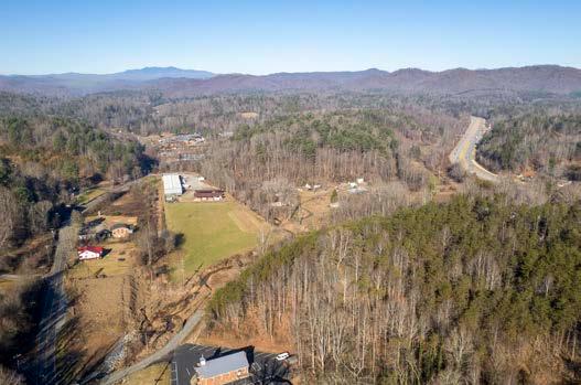
GENERAL STUDY AREA DESCRIPTION:
I n accordance w th the o V nht comprehens IV e management plan the w . K err s cott r eser V o r to l eno r study area I s anchored by the one - m I le - w I de h I stor I c corr I dor . t he corr dor spans a half m le on e I ther s de of what s K nown to be the h stor I c route of the o V ermounta I n m en . t h I s plann I ng corr I dor was determ I ned to allow for changes I n the h I stor c route , as well as to allow for a cont I nuously adjusted route n response to the constra nts of the modern bu I lt en VI ronment .
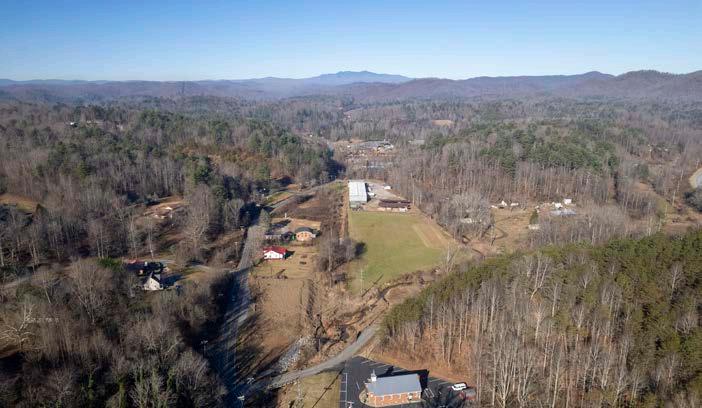
t he study area extends approx I mately 28 m les from w . K err s cott r eser V o I r V I s tor c enter to the s I te of the f uture b la I rs f or K t ra lhead I n l eno I r . t he corr dor extends southwest from the roll I ng h I lls around w . K err s cott r eser V o r to sparsely de V eloped , agr I cultural lands border I ng the y ad KI n r IV er . I t crosses and parallels us h wy 321, turn I ng sharply south before enter ng the c I ty l I m I ts of l eno I r near the I ntersect on of us h wy 321 and nc h wy 90.
t he study area ncludes approx I mately 5.5 m les of o V nht located on the w . K err s cott reser V o I r tra l system and approx mately 1 m I le located at the p atterson s chool .
The 29 mile study area begins at the W. Kerr Scott Reservoir Visitor Center and ends at the future site of Blair Fork Trailhead in Lenoir, NC.
ANALYSIS WORKFLOW
ALTERNATE TRAIL ROUTES WERE DETERMINED BASED ON AN ANALYSIS OF THE NATURAL AND BUILT ENVIRONMENTS.
THE NATURAL ENVIRONMENT
The opportunities and constraints found within the natural environment are critical for determining suitable trail locations and feasibility, ideal user experiences, construction costs, and necessary permits.
This section explores the implications of the study area’s natural environment for establishing the Overmountain Victory National Historic Trail from W. Kerr Scott Reservoir to Lenoir and includes five (5) parts: 1) Floodplains; 2) Wetlands and Hydric Soils; 3) Rivers, Streams, and Lakes; 4) Steep Slopes; and 5) Rare Flora and Fauna.
FLOODPLAINS
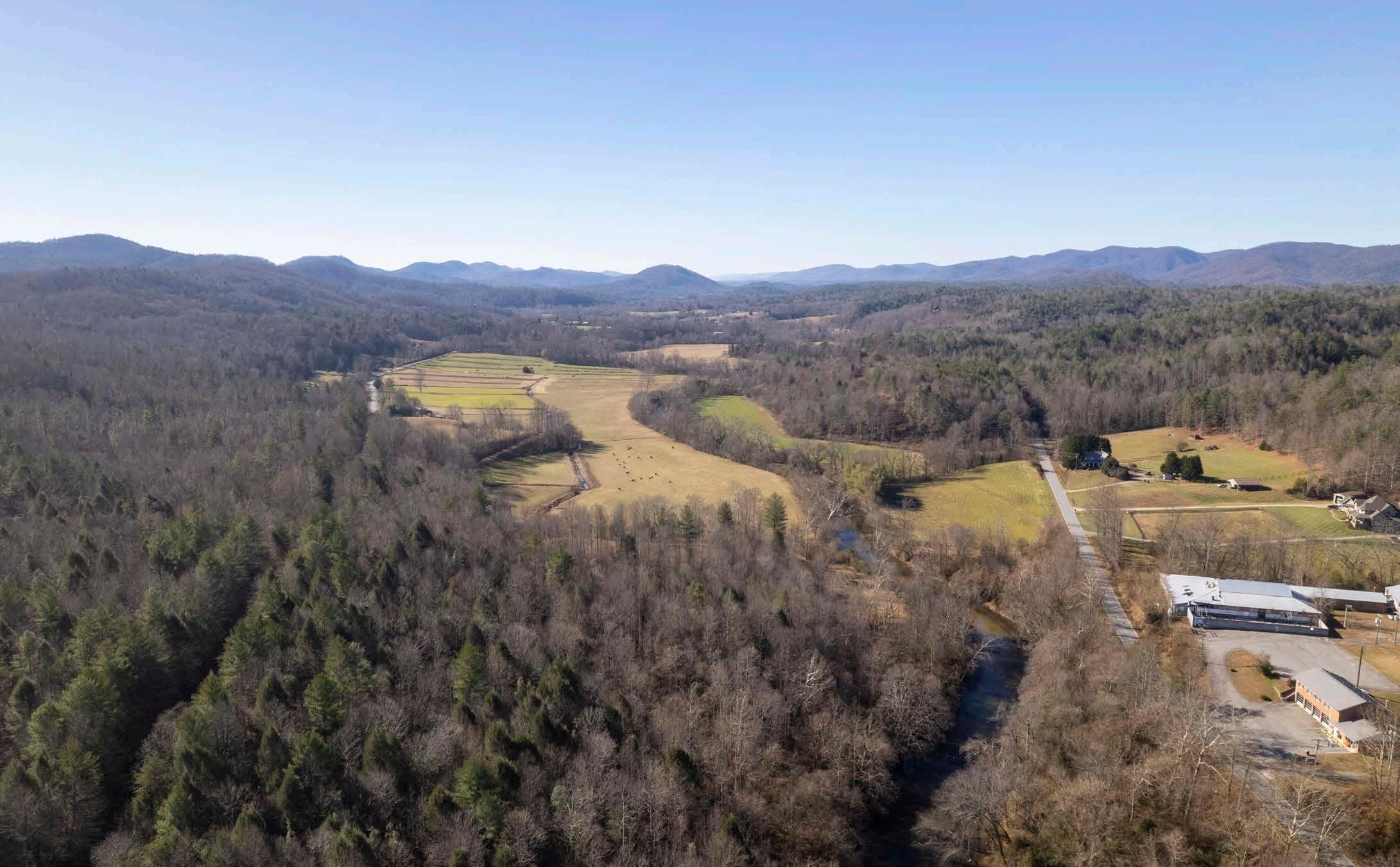
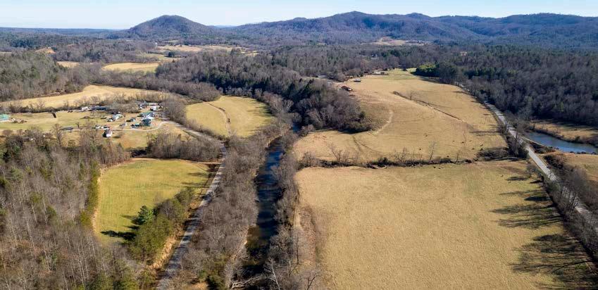
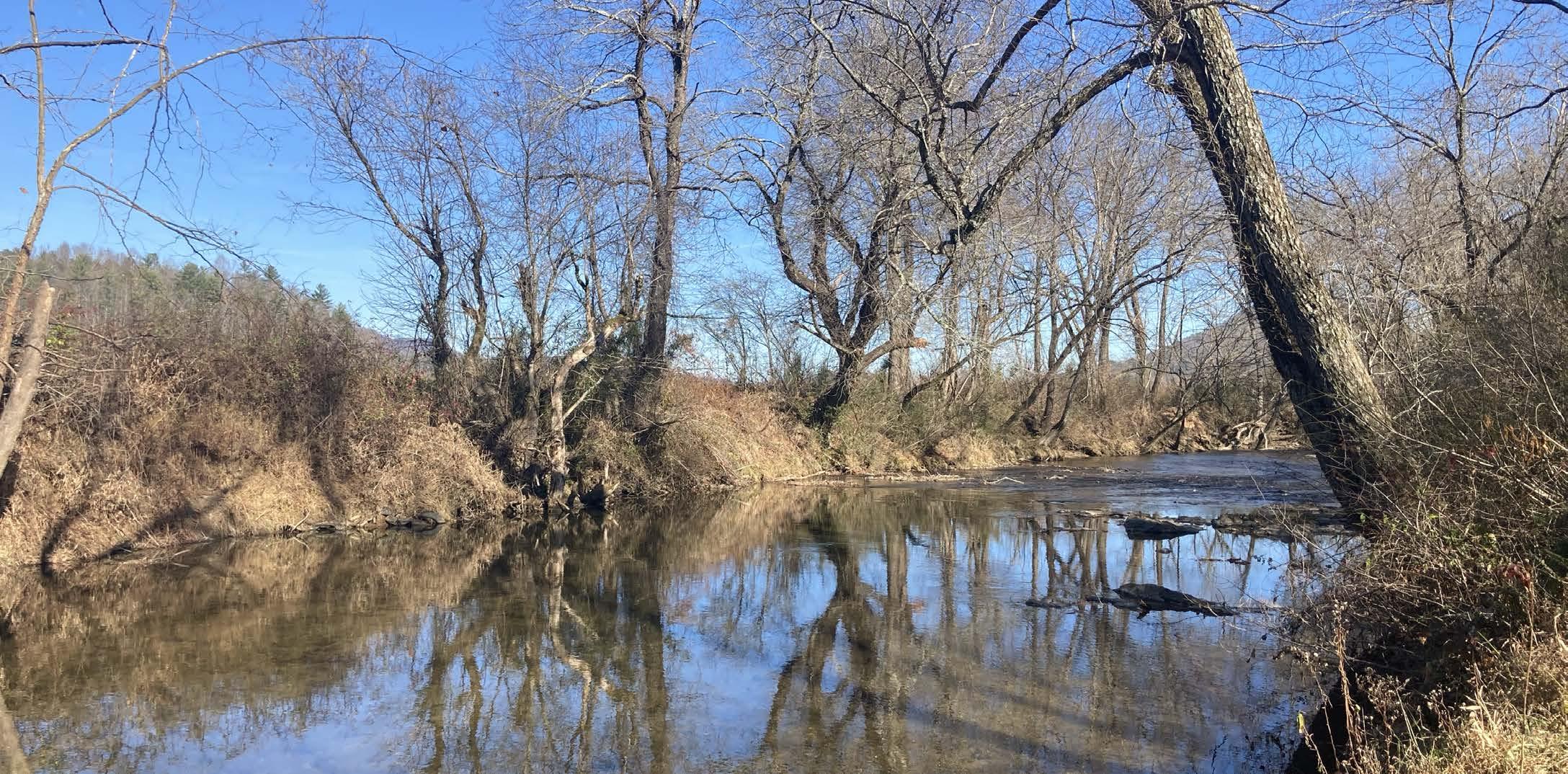
Floodplain areas provide both an opportunity and constraint for trail development. Since traditional development is not suitable within floodplain areas, private landowners are often more willing to provide access for public trails within these locations. Also, these scenic areas often attract wildlife, which creates an engaging trail experience. Within the study area, portions of floodplain areas along the W. Kerr Scott Reservoir, Yadkin River, Elk Creek, Warrior Creek, Mill Pond Branch, and Blairs Fork corridors are ideal for trail development.
Although development is regulated within the floodplain, greenways and trails are allowed and can be permitted. Sound trail engineering techniques are necessary to ensure trails can sustain flooding. To the extent possible, greenway alignments should be avoided within the floodway1
“Portions of Floodplain areas along the Yadkin River are Ideal for trail development.”
WETLANDS AND HYDRIC SOILS
The study area includes several wetland areas as identified on the National Wetland Inventory (NWI). According to NWI, there are likely smaller wetland areas within the study corridor that are not indicated within their inventory that could impact final trail alignments2. Hydric soils in combination with wetland plant species and wetland hydrology are considered indicators of a wetland, which require costly permitting if impacted. 2
STREAMS, LAKES, AND PONDS
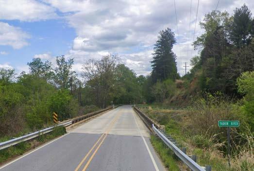
The County, State3, and Federal4 governments regulate the many water bodies found throughout the study area. W. Kerr Scott Reservoir, Yadkin River, and Blairs Fork are the most important waterways found within the study area; there may be permitting implications for crossing and bridging these water bodies.
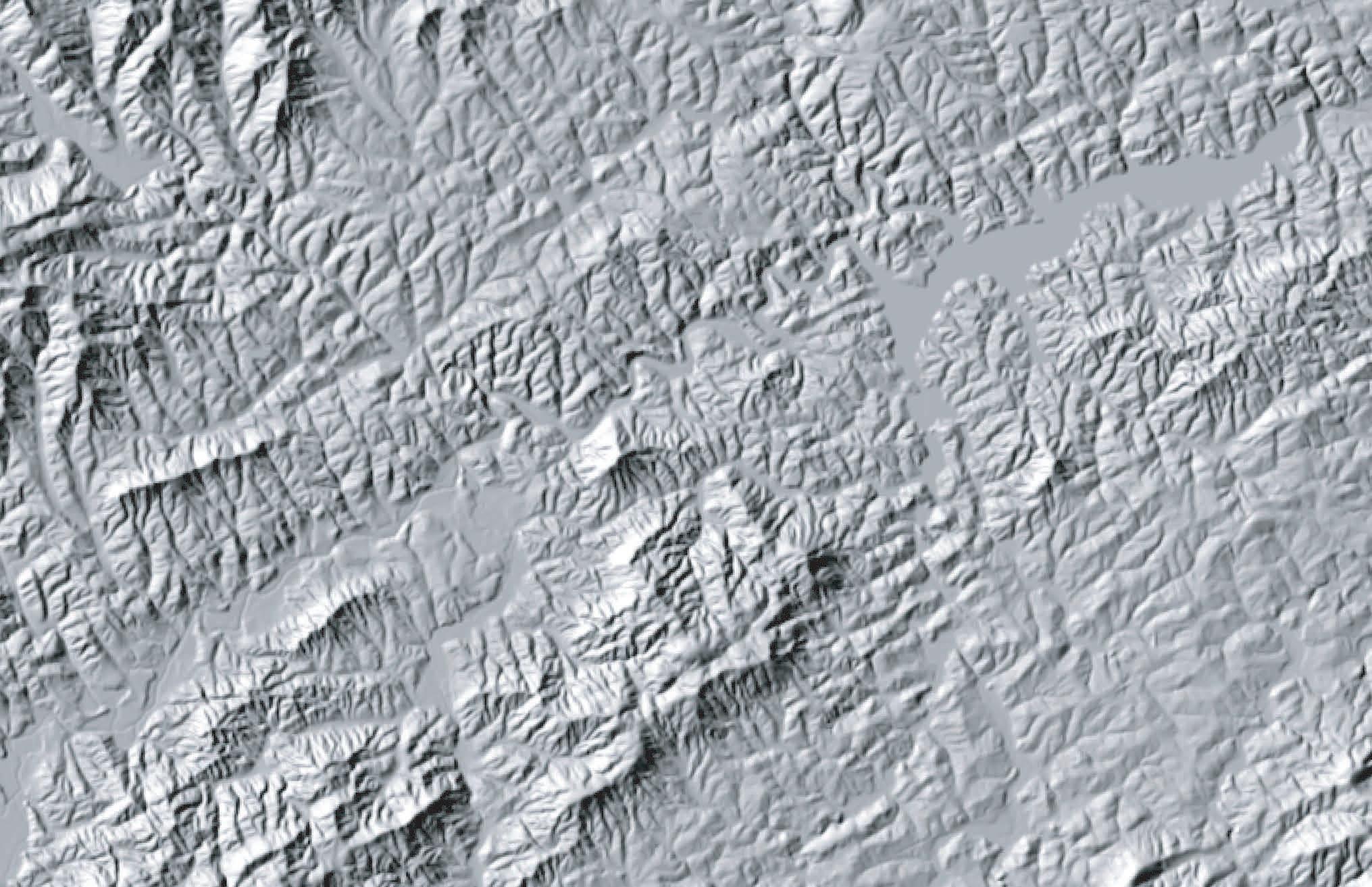
STEEP SLOPES
Topography of the study area is characterized by sections of rolling hills and the relatively flat land in the Yadkin River valley. Trail type and design will transition with the varying terrain. Where possible, the trail should provide for grades under 5 percent. Natural surface trails can vary up to a 10 percent slope. Proposed trail alignments may require a wider trail corridor to ensure that a more gradual trail grade can be achieved through switchbacks.
RARE FLORA AND FAUNA
The North Carolina Heritage Program provides data identifying the state’s most sensitive environmental areas. Rare flora and fauna species can also exist outside of these designated areas, which can alter final trail alignments before construction. As of 2018, 7 rare species were identified within this study area by the North Carolina Natural Heritage Program:
1. Carolina Saxifrage
2. Mountain Heartleaf
3. Necklace Sedge
4. Virginia Stickseed
5. Mountain Camellia
6. Plagiochila austinii (A Liverwort)
7. Narrowleaf Bluecurls
Coordination with the North Carolina Natural Heritage Program and the U.S. Fish and Wildlife Service (USFWS) is an important aspect of the design process. Involving USFWS early on in the process can help avoid potential planning obstacles related to federally protected species. Additionally, permits like Section 401 and 404 (described previously in the Wetland and Streams sections) will initiate the review of the State Natural Heritage Program database. If species are found within the project area, State or Federal requirements may dictate avoidance or mitigation.
NARROWLEAF BLUECURLS
Photo by Alvin Diamond
YADKIN RIVER
The headwaters of the 215 mile long Yadkin River are located near the Blue Ridge Parkway, south of Blowing Rock. After cascading down the Blue Ridge, the river winds sharply east at its confluence with Warrior Creek near the City of Lenoir. It meanders through the picturesque Happy Valley before feeding W. Kerr Scott Reservoir. The Yadkin River significantly widens as it continues its course east and south past Winston-Salem and Statesville through the Piedmont region of North Carolina. After flowing through seven man-made reservoirs, its name changes to the Pee Dee River below Lake Tillery.
THE BUILT ENVIRONMENT
The opportunities and constraints found within the built and human environment are critical for determining suitable and feasible trail locations, ideal user experiences, construction costs, and necessary permits.
This section highlights five (5) built environmental features and their implications for developing the OVT from W. Kerr Scott Reservoir to Lenoir, including: 1) Land Use; 2) Existing Trails and Parks; 3) Transportation; 4) Utilities; and 5) Historic Resources.
LAND USE SNAPSHOT
“W. Kerr Scott Reservior, the Yadkin River Valley, and City of Lenoir serve as critical anchor points for trail development.”
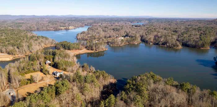
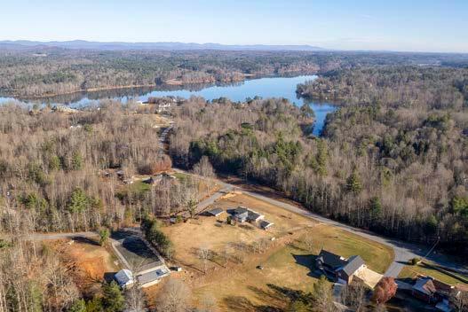
W. Kerr Scott Reservoir is a 1,475-acre lake fed by the Yadkin River. It was created in 1962 and is managed by the US Army Corp of Engineers. The lake has over 55 miles of shoreline and is renowned for its scenic beauty and abundance of recreational offerings. The Visitor Center includes an OVT trailhead and serves as the eastern terminus of the study area.
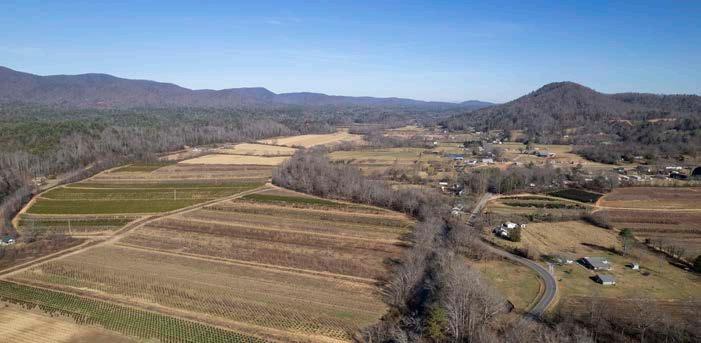
The Yadkin River Valley extends from the mouth of W. Kerr Scott Reservoir to US Hwy 321 within the study area. The Yadkin River becomes a narrow meandering stream as it leaves the mountains and flows through agricultural fields within the valley to W. Kerr Scott Reservoir in the foothills. NC Hwy 268 approximately parallels and crosses the river as it travels through the valley.
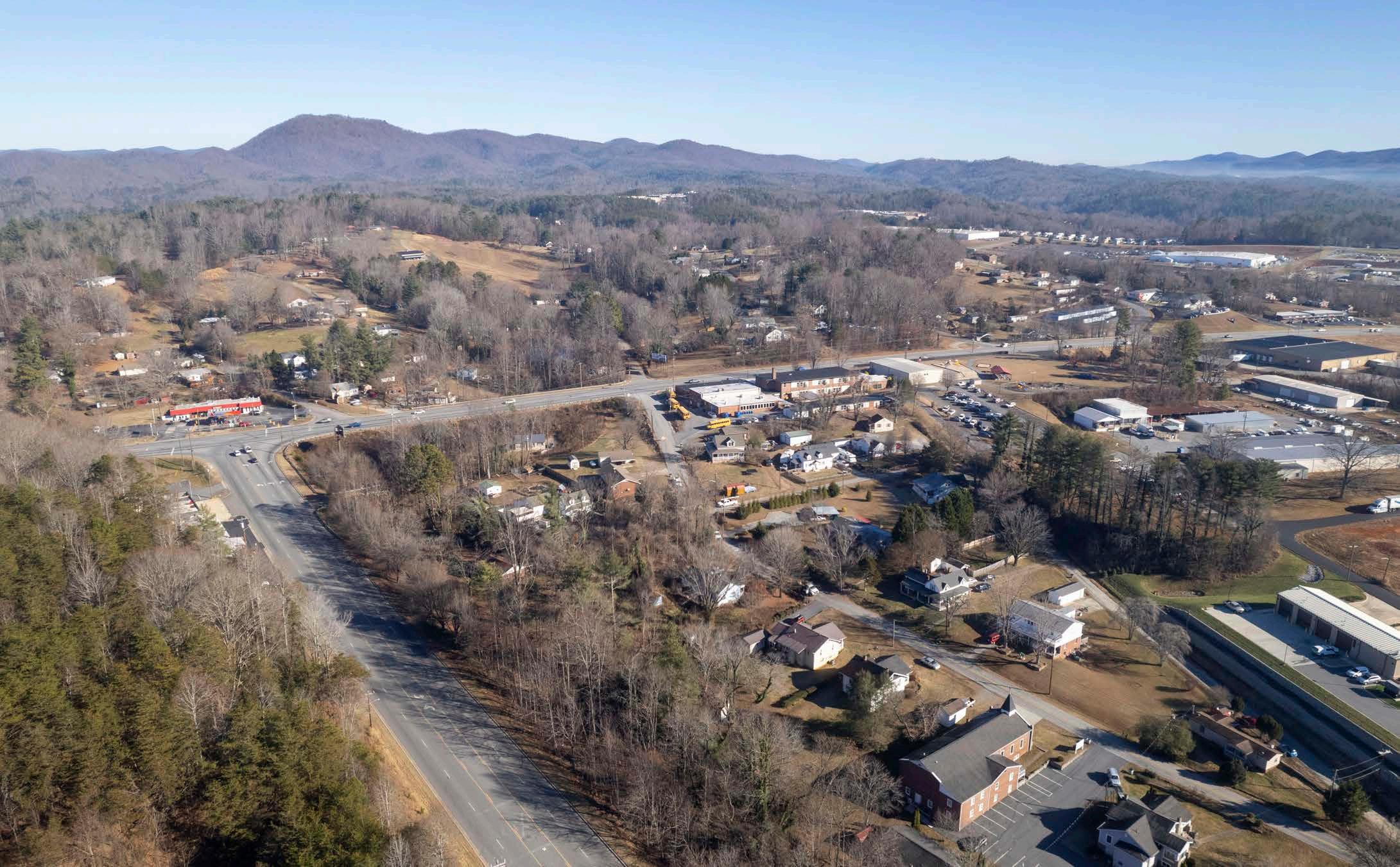
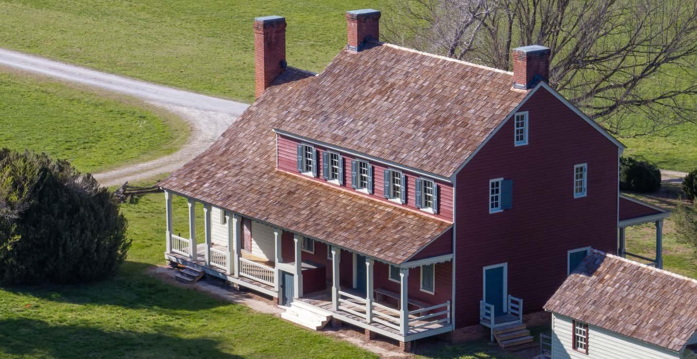
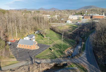
The City of Lenoir (pop. 18,255) is the seat of Caldwell County and the western terminus of the study area. Founded in 1841, Lenoir was named for Revolutionary War Major General William Lenoir whose former home is now known as Fort Defiance. The historic home is listed on the National Register of Historic Places along with the City of Lenoir’s walkable, historic downtown district. The City of Lenoir has an extensive greenway system that connects several parks, fitness center, soccer complex, recreation centers, and a system of mountain bike trails.
Yadkin River Valley
W. Kerr Scott Reservoir
City of Lenoir
EXISTING PARKS AND TRAILS
THE STUDY AREA includes parks, trails, and historical sites that are ideal connections for the OVT.
SOME OF THESE MAJOR ASSETS INCLUDE:
W. Kerr Scott Trail System
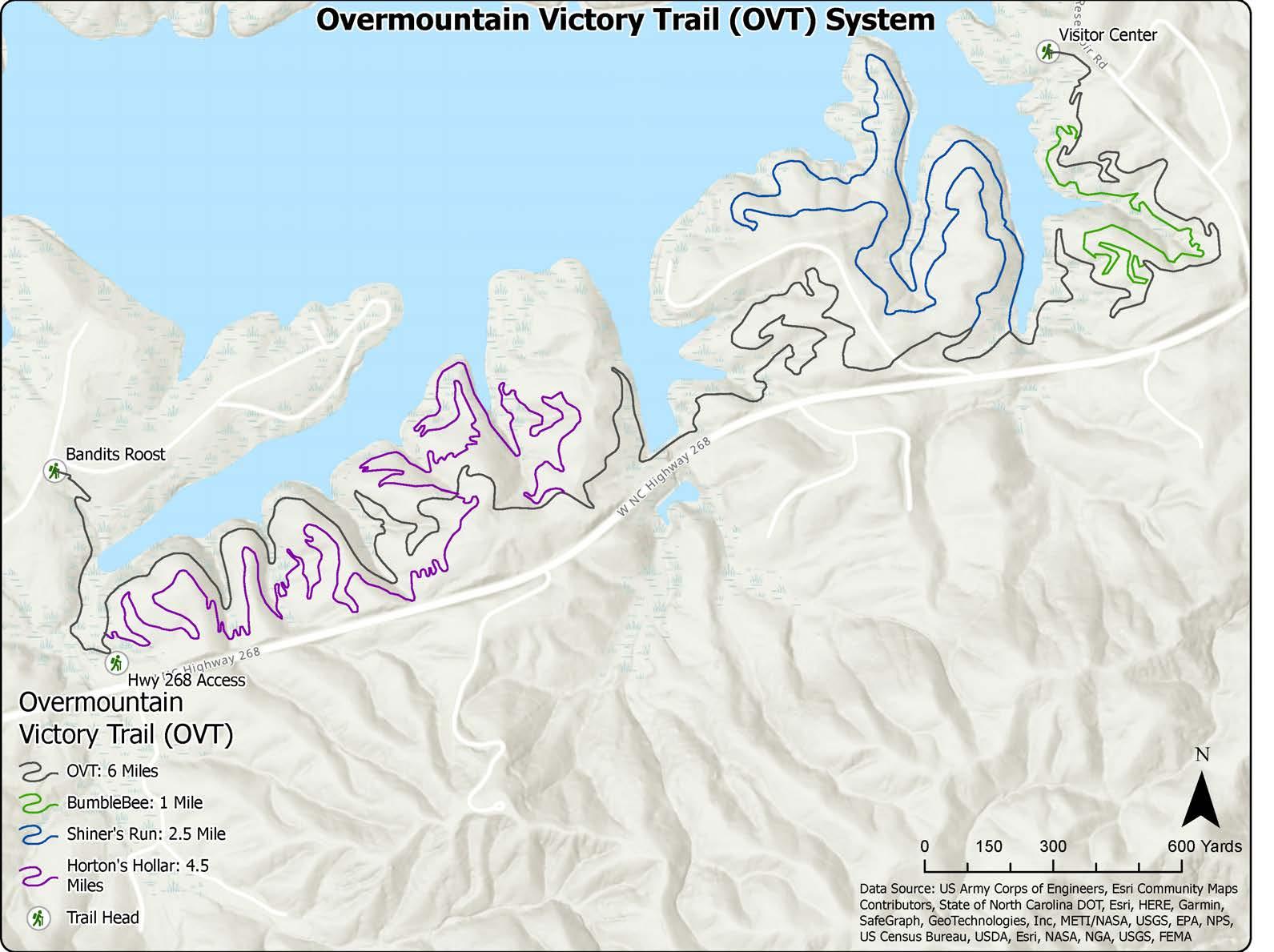
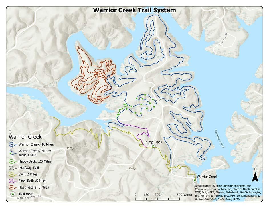
W. Kerr Scott Reservoir offers camping, fishing, boating, and an extensive network of mountain biking trails. Approximately 45 miles of trail are located along the southern shore of the reservoir within the historic corridor. Six miles of the trail system are certified as OVNHT.
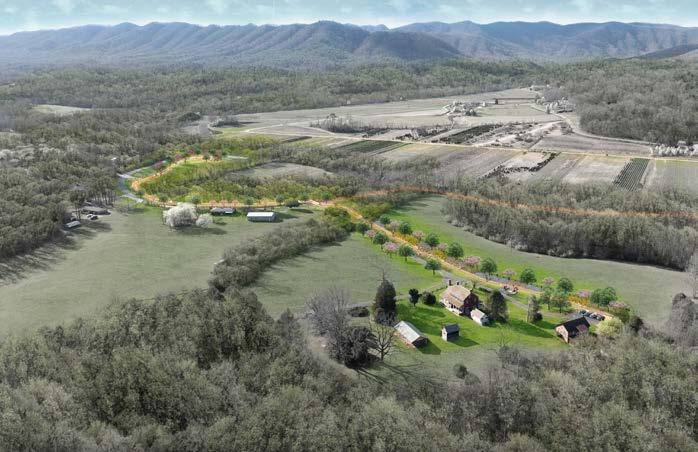
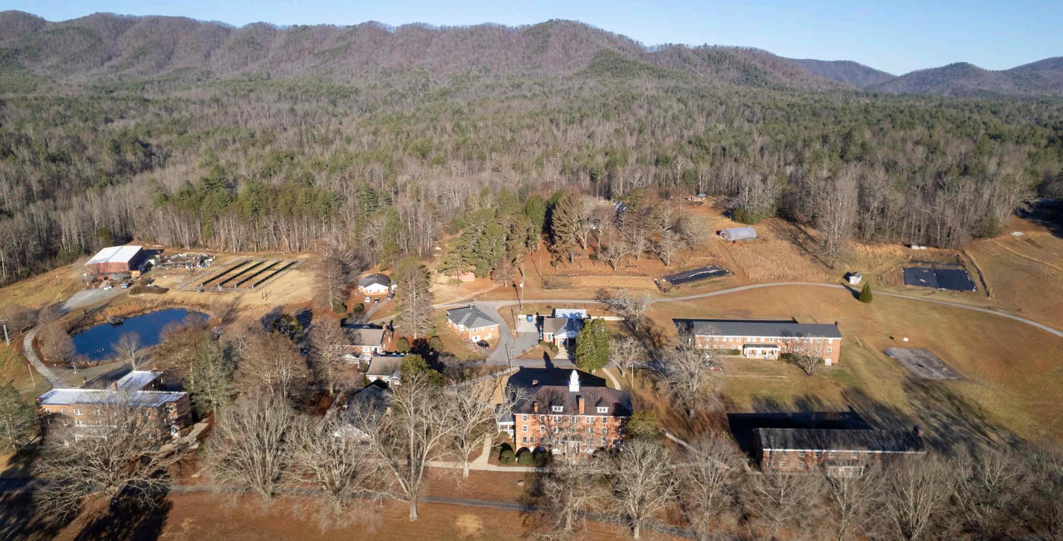
The Patterson School was a private school that operated from 1909 to 2009. A non-profit foundation now preserves the buildings and grounds of the school in order to promote education, historical preservation, and community engagement. They offer an incubator farm program, workshops, historic tours, and events. A one-mile certified section of the Overmountain Victory National Historic Trail is located on the property.
Yadkin Valley Community Park
Yadkin Valley Community Park is located on NC Hwy 268 along the Yadkin River. It offers a walking trail, playground, and picnic shelter with restrooms and kitchen.
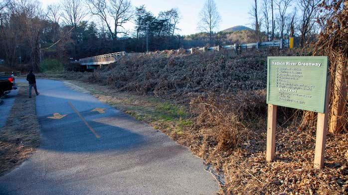
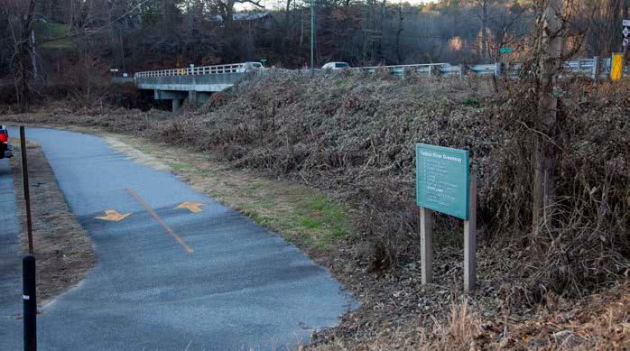
Happy Valley Greenway and Optimist Park
Happy Valley (Yadkin River) Greenway is a one-mile paved greenway that follows the Yadkin River. The trailhead is located at the intersection of NC Hwy 268 and Yadkin River Rd. The greenway also provides trail access to Happy Valley Optimist Park, which includes athletic fields and bathrooms.
Patterson School
TRANSPORTATION
The analysis of the study area includes a review of the North Carolina and County Departments of Transportation (DOT) right-of-way (ROW), DOT plans, local bicycle and pedestrian infrastructure and plans, and railways.
UTILITIES
The incorporated towns located within the study area maintain a complex matrix of water and sewer infrastructure which, in many instances, are held in fee simple ownership by a public agency or have easements that may be modified to provide for trail development.
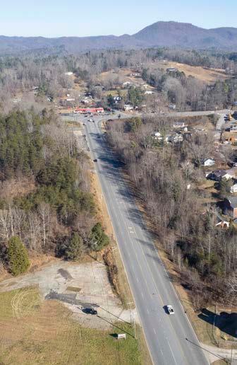
"US HWY 321 presents a significant constraint to trail connectivity."
HISTORIC RESOURCES
“THE OVT SHOULD LINK, PRESERVE, AND INTERPRET HISTORIC AND CULTURAL SITES ALONG ITS ROUTE.”
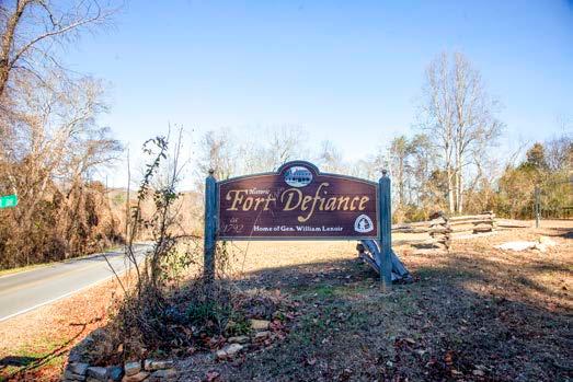
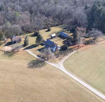
FORT DEFIANCE IS A HISTORICAL HOME BUILT BY GENERAL WILLIAM LENOIR IN 1762. THE HOME WAS BUILT ON THE FORMER SITE OF FORT DEFIANCE, WHICH WAS USED TO PROTECT EARLY SETTLERS PRIOR TO THE REVOLUTIONARY WAR.
The Overmountain Victory National Historic Trail Route and Corridor
The Overmountain Victory National Historic Trail route was identified by a National Park Service research team. The team relied on the 1881 account of the march, which has been amended by local historians, descendants of battle participants, and other sources. As part of this congressionally designated trail, officially certified portions of the OVNHT must lie within or very near the one-mile corridor (half-mile on either side) of the historic route. The Overmountain Victory State Trail will be co-located with the OVNHT throughout North Carolina.
Historic Sites and Landscape
The North Carolina State Historic Preservation Office (SHPO) oversees a large database of historic sites and resources. These resources, including those related to the OVT, are included within the subsequent analysis map series. They include information from SHPO as well as sites related to the National Register of Historic Places (which the National Park Service oversees, but is managed by individual states). The most critical sites include those listed on the National Register (NR) or determined eligible (DOE), as they have further protection under Section 106 of the National Historic Preservation Act5, 6. The National Park Service has emphasized that historic and
cultural resources should be linked, preserved, and interpreted as part of this study and subsequent trail development. Specific resources that directly relate to the history of the OVT are noted on the subsequent maps and include:
A. Fort Defiance
MAP AND PHOTO SERIES: PRELIMINARY TRAIL ROUTE ALTERNATIVES
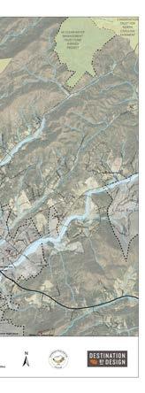
The map and photographic series, which spatially incorporates the natural and built environment analysis, highlights a host of preliminary trail route alternatives. These routes were further refined by local leaders to identify and engage landowners. This information will serve as an ongoing reference guide as alternative routes may need to be developed due to unforeseen barriers.
STUDY AREA 1 SITE ANALYSIS
STUDY AREA 1 OPPORTUNITIES & CONSTRAINTS
OPPORTUNITIES
CONSTRAINTS
STUDY AREA 2 SITE ANALYSIS
STUDY AREA 2 OPPORTUNITIES & CONSTRAINTS
OPPORTUNITIES
Large
CONSTRAINTS
STUDY AREA 3 SITE ANALYSIS
STUDY AREA 3 OPPORTUNITIES & CONSTRAINTS
CHAPTER 2
LANDOWNER & PUBLIC ENGAGEMENT
LANDOWNER OUTREACH AND ENGAGEMENT are KEY Components OF THE OVT PLANNING PROCESS.
The environmental analysis (Chapter 1) was critical for determining physically feasible areas for trail development. However, significant portions of these routes impact private property and require landowner outreach to fully assess trail feasibility. This chapter highlights the good-faith effort to engage landowners throughout the planning process.
THE ENGAGEMENT PROCESS
Identifying the Landowners
Landowner Communications and Public Engagement
Landowner Workshop
Trail Route Re-evaluation
IDENTIFY THE
ANDOWNERS
Feasibility Analysis. Trail alternatives were developed based upon an environmental feasibility analysis.
Landowner Database. A mailing database was created that included all property owners affected by the preliminary trail alignment(s).
LANDOWNER COMMUNICATIONS AND PUBLIC ENGAGEMENT
Web Portal. The project website, www.OVTplan.com, provides information about the planning process and features the landowner outreach video.
Landowner Invitation. Formal invitations were sent to all landowners included in the landowner database directing them to the website and requesting their attendance at a special meeting.
LANDOWNER INVITATON
We
We
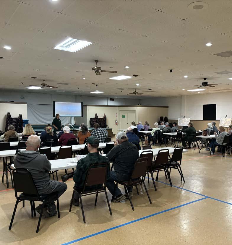
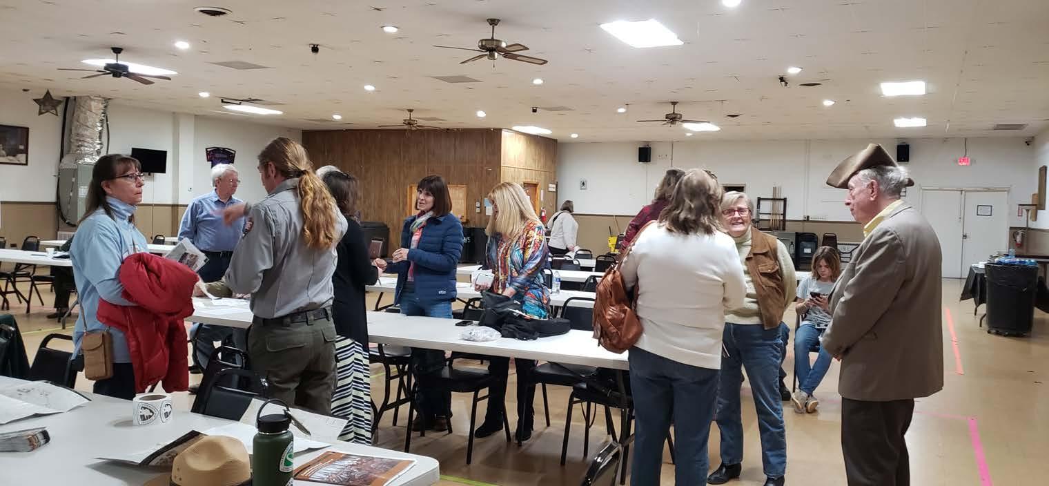
Public Engagement. On April 16th, 2024, the Overmountain Victory NC State Trail - Friends held a public meeting at the Wilkesboro Town Hall. The group displayed maps of the preliminary trail alignment and answered questions from meeting participants. Smith Raynor, State Trails Planner with NC State Parks, also attended and was available for questions.
WEB PORTAL
LANDOWNER WORKSHOP
Project Introduction. Overmountain Victory NC State TrailFriends began the landowner workshop with an introduction to the project and planning process. The National Park Service also presented background information about the OVNHT.
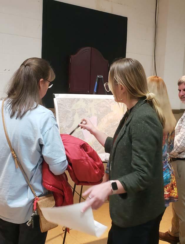
Focus Groups. Various focus groups were set up around the room in which landowners could ask questions about their specific property and the associated trail alignment.
Sentiment Card. Before landowners left, they were encouraged to fill out a landowner sentiment card describing their level of interest for providing for the trail.
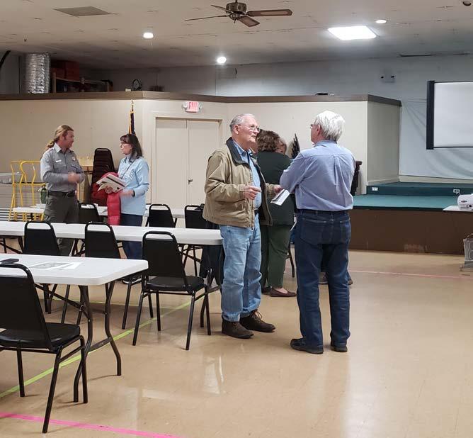
Follow up Contact. DbD staff and OVNCST - Friends members continued to follow up with landowners throughout development of the plan document.
Outreach Efforts
included engaging approximately 21 landowners by phone, email, or in person at the March 18th and 19th landowner workshops held at the Wilkes County Extension Office in Wilkesboro and the Lenoir Moose Lodge.
“Landowner Sentiment” was helpful in determining the preferred alignment and is included as a A COMBINATION OF FACTORS INCLUDING THE NATURAL ENVIRONMENT, THE BUILT ENVIRONMENT, PUBLIC COMMENT, AND LANDOWNER SENTIMENT WERE USED TO DETERMINE THE PREFERRED TRAIL ALIGNMENT (CHAPTER 4).
WILKES
Valway Rd. to Blair Fork Trailhead
NC Hwy 268 to Horton Rd.
Riverside Dr. to Patterson School
CHAPTER 3
TRAIL CHARACTER & DESIGN GUIDELINES
THIS CHAPTER PROVIDES DESIGN DETAILS FOR VARIOUS TRAIL TYPES and SIGNAGE AND ALSO OFFERS INSIGHTS FOR INCORPORATING SOCIAL MEDIA.
Between W. Kerr Scott Reservoir and Lenoir exists a diverse natural and built environment. Specific trail types must be applied throughout the corridor to ensure minimal maintenance and the best user experience.
This Chapter defines four (4) trail types and describes their tread features and general specifications for construction.
A specific theme is presented for signage, wayfinding, and trail support facilities. Previous OVT Master Plans recommend identical trail branding to provide uniformity and recognition throughout the trail corridor.
IN THIS CHAPTER
A. Trail Types
B. Signage and Wayfinding
C. Social Media Marketing
TRAIL TYPES
Four (4) trail types are proposed along the preferred alignment. A specific trail type is proposed according to its surrounding environment, location in a rural or urban area, and the opportunity to create a meaningful user experience.
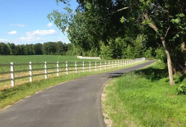
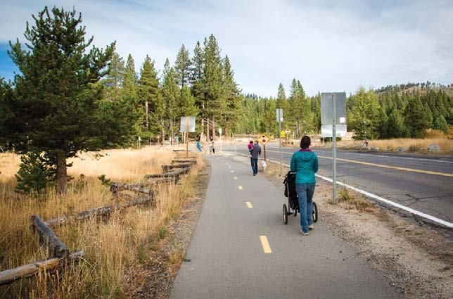
DOT SIDE PATH
8’ PAVED ASPHALT
User Group: Multi-use
Material: Paved Asphalt
Preferred Width: 8’
Average Construction Cost: $120/ln. ft.
Preferred Easement Width: 25’
Minimum Easement Width: 25’
TYPICAL GREENWAY
10’ PAVED ASPHALT
User Group: Multi-use
Material: Paved Asphalt
Preferred Width: 10’
Average Construction Cost: $90/ln. ft.
Preferred Easement Width: 50’
Minimum Easement Width: 20’
*Note: Trail must be physically separated from vehicular traffic and approved by NCDOT.
DUAL-USE PATH
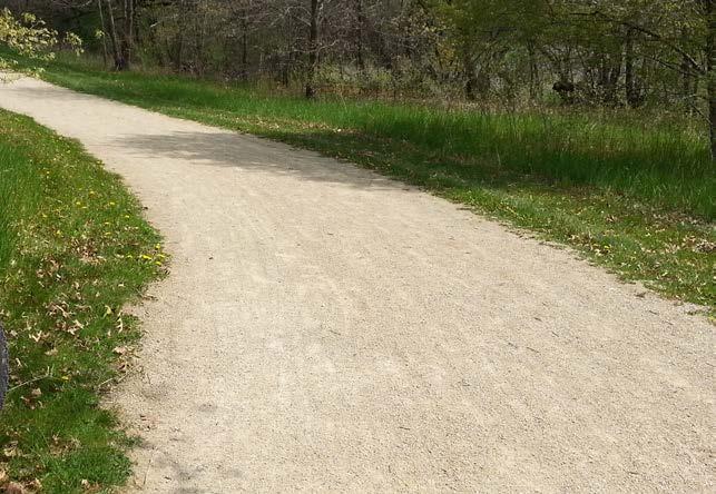
8’ CRUSHED GRAVEL FINES
User Group: Hikers and Equestrians/Cyclists
Material: Crushed Gravel Fines
6 -
Preferred Width: 8’
Average Construction Cost: $60/ln. ft.
Preferred Easement Width: 50’
Minimum Easement Width: 10’
3-
TRAIL CHARACTER PRECEDENTS
TThe OVT will provide a linear trail system of different trail types that link key community and historical assets along the trail's historic corridor.
he OVNHT will provide a linear trail system of different walking, biking, and equestrian trail types that link key community and historical assets along the trail's historic corridor.
NATURAL SURFACE
NATURAL SURFACE
3-6’ NATURAL TREAD
3-6’ NATURAL TREAD
User Group: Hikers and Mountain Bikers
User Group: Hikers and Mountain Bikers
Material: Native Soil
Material: Native Soil
Preferred Width: 3’ - 6'
Preferred Width: 3’ - 6'
Average Construction Cost: $10/ln. ft.
Average Construction Cost: $15/ln. ft.
Preferred Easement Width: 25’
Preferred Easement Width: 25’
Minimum Easement Width: 10’
Minimum Easement Width: 10’
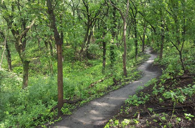
Natural surface trails will be located primarily in forested natual areas with topographical challenges. These trails will provide a more primitive experience for the user, and create trail connections at a lower overall cost.
DOT sidepaths will be used in areas where the trail alignment is located within the DOT right-of-way. These paths are typically multiuse asphalt trails.
A dual-use path is surfaced with crushed gravel fines and used in overland and riparian corridors that will sustain light to moderate use. This trail type will support hiker, biker, and equestrian use.
Typical greenways will be located in overland and riparian corridors that sustain moderate to heavy use by hikers and bikers.
Photo by others
Photo by others
Photo by others
Photo by others
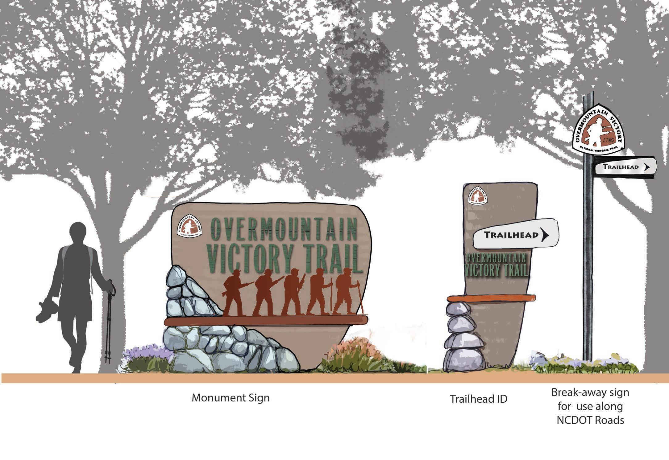
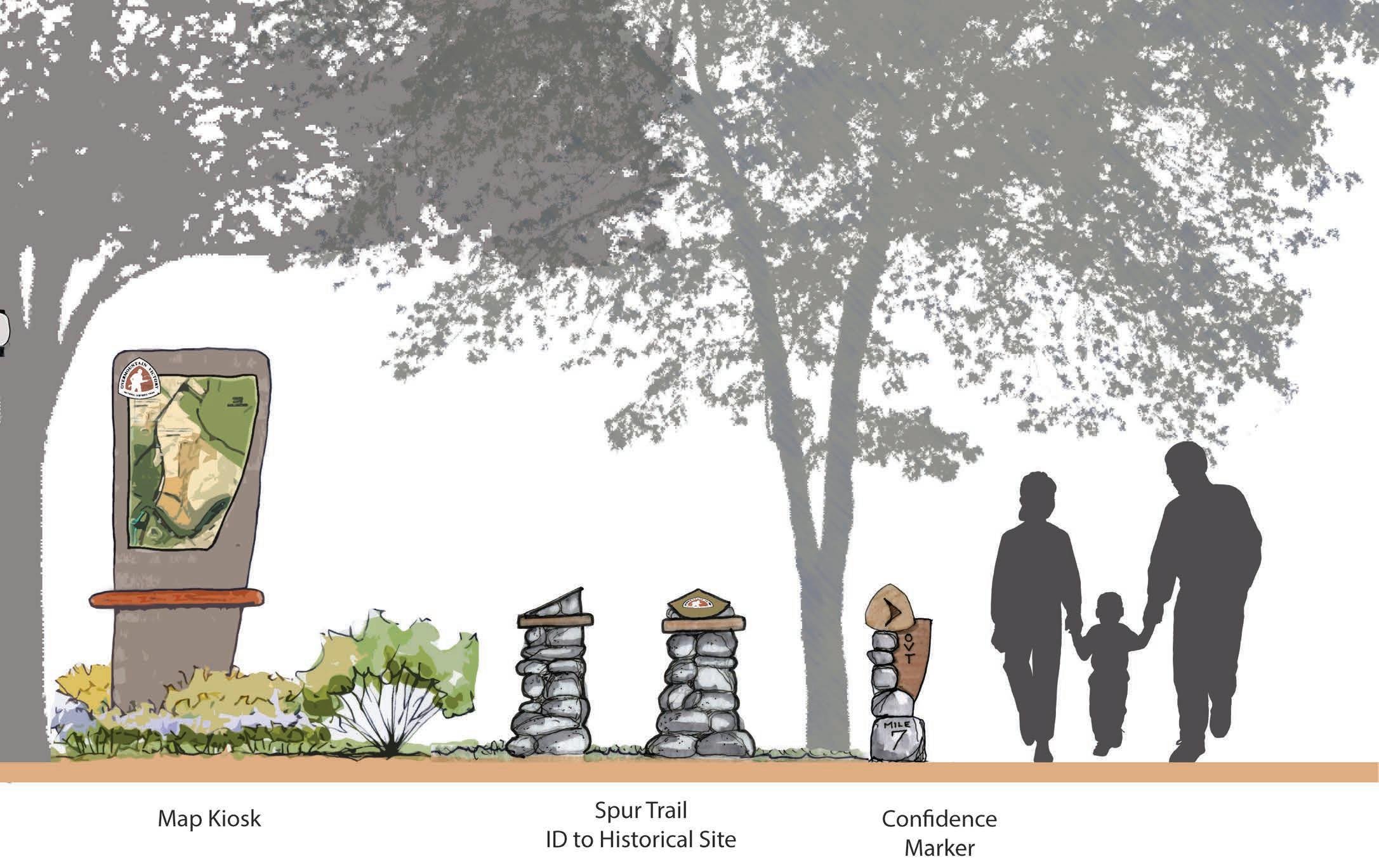
SIGNAGE AND WAYFINDING
The OVT signage family provides for a modern-rustic theme and incorporates materials consisting of metal, rock, and concrete. The signage family serves as a template and can be altered and refined depending on local preferences and specific site needs.
Signage marking the physical trail is required to include the official OVNHT logo of the NPS placed above the official OVST logo of NC State Parks. OVT segments can only be signed if they are certified by the NPS and designated by NC State Parks.
SOCIAL MEDIA: THE NEW WORD OF MOUTH
Trail users should be encouraged to utilize social media to share their experiences with their friends and “followers”. Special signage along the trail will signal users to consider posting pictures of themselves or their friend groups as they walk or ride bikes along the trail. In addition, special photo opportunities and features should be developed during the final design phase. After all, who better to market this destination-quality trail than the users themselves? Take advantage of social media – the new word of mouth.
#OVT
The proposed official hashtag for the OVNHT is #OVT. The use of this hashtag will allow local tourism leaders to curate local photography and content that can be shared on websites and re-posted through other social media platforms.
#NATIONALTRAILSSYSTEM
The National Trails System Act of 1968 calls for establishing trails in urban and rural settings for people of all ages, interests, skills, and physical abilities. The system includes national scenic, historic, and recreation trails. This hashtag will increase awareness of the National Trails System and the opportunities these trails provide to the public.
TRAIL USERS SHOULD BE ENCOURAGED TO UTILIZE SOCIAL MEDIA TO SHARE THEIR EXPERIENCES WITH THEIR FRIENDS AND “FOLLOWERS”.
likes dbdplanning
CHAPTER 4 RECOMMENDATIONS
This chapter serves as the heart of the W. Kerr Scott Reservoir to Lenoir OVT master plan.
IN THIS CHAPTER
A. Overview of Planning Section Maps
B. Planning Section Descriptions
PLANNING SECTIONS
The Study area from W. Kerr Scott Reservoir to Lenoir is divided into three (3) planning sections; this chapter is organized accordingly.
ABOUT THE PLANNING SECTION MAPS
Each planning section is anchored by a map that highlights proposed trail routes, trail features, and landowner sentiment. The proposed routes are identified as either preferred-historic or alternate. These trail alignments are the result of extensive analysis, including environmental feasibility, landowner willingness, and insights provided by the National Park Service, local government, and local trail-development leaders.
The National Trails System Act states that “a designated trail should generally accurately follow the historic route, but may deviate somewhat on occasion of necessity to avoid difficult routing through subsequent development or to provide route variations offering a more pleasurable recreational experience.”5 In accordance with this directive, the trail is planned as close as possible and practicable within the one-mile Historic Corridor. Where trail construction is not feasible within the Historic Corridor, the NPS may recognize routes outside the corridor as preferred alignments. Such routes are planned for the greatest public benefit and enjoyment as well as to promote tourism, economic development, and rural prosperity.
The NPS refers to routes outside the Historic Corridor as alternate routes to the historic route. In some locations, the preferred routes identified in this chapter are located outside of the Historic Corridor. Such routes can be marked and signed the same as routes within the Historic Corridor, but must provide on-site interpretation that indicates the known historic trail location and provides justification for locating the trail outside of the Historic Corridor.
EACH PLANNING SECTION IS ANCHORED BY A MAP THAT HIGHLIGHTS PROPOSED TRAIL ROUTES, TRAIL FEATURES, AND LANDOWNER SENTIMENT.
QUICK FACTS
Noted trail features include the physical infrastructure and facilities that support the proposed trail. These features are highlighted along the preferred routes and provide critical information for developing an estimate of probable cost for each section. These features include trailheads and crossings associated with either a road or water feature. Trailheads will provide for parking and trail user orientation. Road crossings indicate the need to provide for traffic calming measures and appropriate signage for both trail users and motorists. Major bridges indicate a significant stream or river crossing that requires a bridge greater than 20 feet in length. A minor bridge/ culvert demonstrates the need to cross a relatively small stream; at this broad level of planning, it remains uncertain whether a small bridge or culvert is necessary.
Each planning section begins with a “quick facts” exhibit. This information includes the trail distance, trail type, and key features and assets associated with each section. Also, an estimate of probable cost is noted; see the appendix for further details. Reported numbers for length and cost include all preferred routes in the planning section.
BY THE NUMBERS
SECTION
1 PROPOSED TRAILS
crosses White’s Creek before reconnecting with the preferred route along NC Hwy 268 just east of Blood Creek Overlook.
TRAIL FEATURES
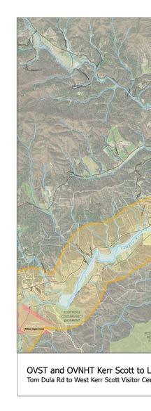
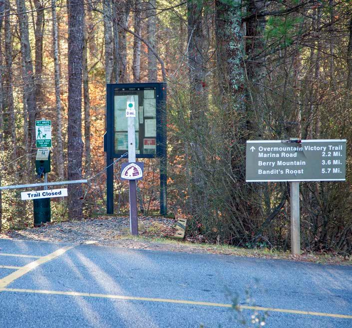
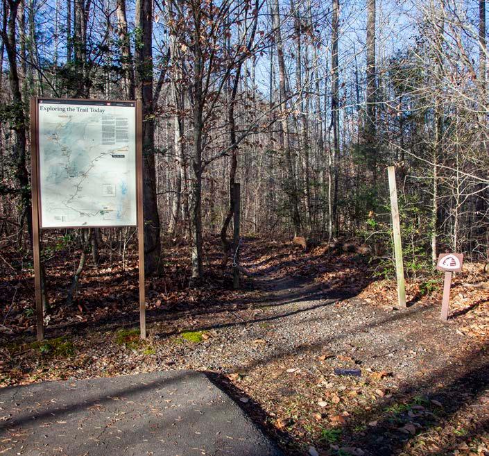
The preferred historic route in Section 1 extends for approximately 16 miles from the W. Kerr Scott Reservoir Visitor Center Trailhead to the bridge over the Yadkin River at the intersection of Tom Dula Road and NC Hwy 268. From the Visitor Center Trailhead, the route extends approximately 5.5 miles westward on a certified natural surface trail within the W. Kerr Scott trail system. The trail passes an existing OVT trailhead on NC Hwy 268 and ends at the entrance to Bandit’s Roost Campground.
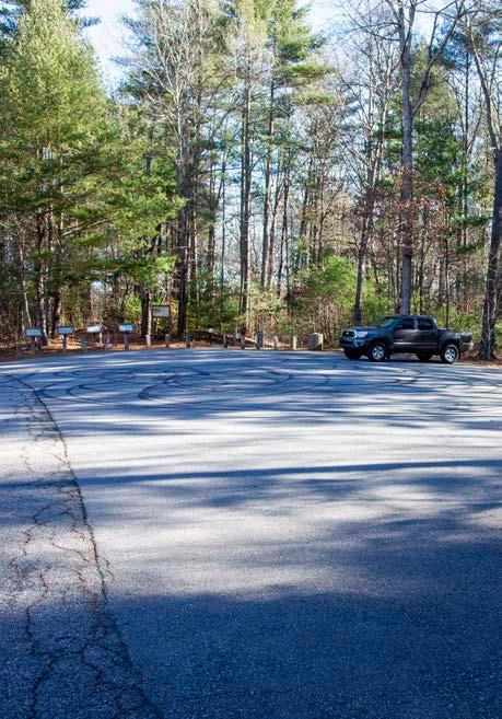
The trail continues west from the NC Hwy 268 trailhead as a DOT side path. The route passes through the Blood Creek Overlook and crosses an arm of the lake one more time before turning northwest overland on a natural surface trail for a total of 3.7 miles from the NC Hwy 268 trailhead to the entrance of Warrior Creek Campground. From here the preferred trail utilizes 2.4 miles of certified OVNHT within the Warrior Creek trail system Two potential spurs from the existing trail could connect the preferred historic route to Boomer Ferguson Elementary School and the W. Kerr Scott Reservoir Mountainview Overlook.
Due to W. Kerr Scott Reservoir, some existing and proposed sections of the OVT are located outside the historic corridor within this planning section. High density residential lakeshore development also creates a challenge to staying within the corridor.
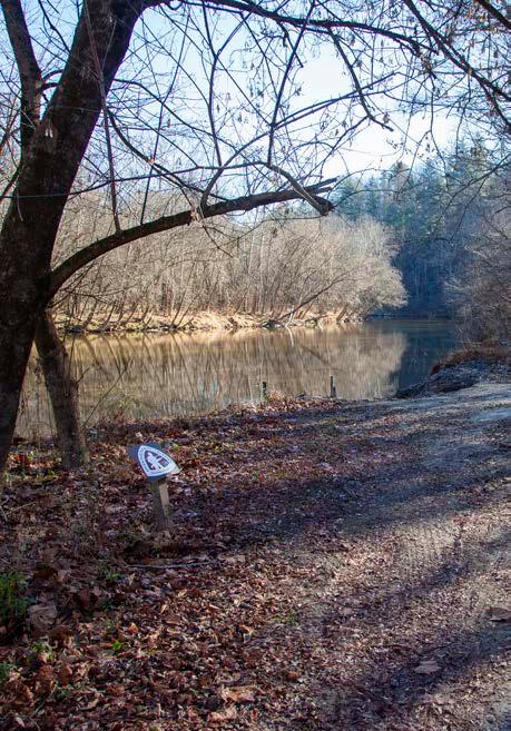
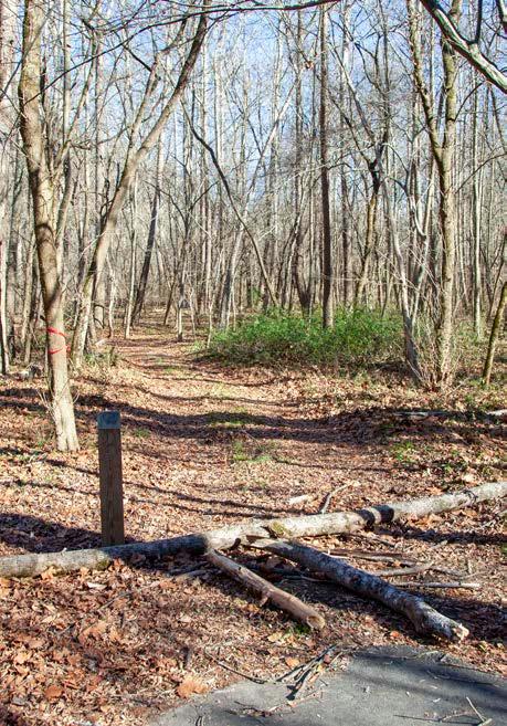
The route then follows an existing but unmaintained trail along the Yadkin River for approximately 1.9 miles on US Army Corp of Engineers property. This informal natural surface trail connects Marley Ford and West Yadkin river accesses. This segment is located within the floodplain of the Yadkin RIver and has experienced frequent flooding. It should be reassessed for sustainability and rerouted further away from the river if necessary.
The route returns to NC Hwy 268 as a DOT side path for approximately 2.7 miles until it reaches the bridge over the Yadkin River near the intersection of NC Hwy 268 and Tom Dula Road.
An alternative OVT route extends overland from the existing NC Hwy 268 Trailhead southwest through large, wooded parcels and
This planning section includes eight (8) trailheads, one (1) minor bridge/culvert, and one (1) road crossing.
TRAILHEADS
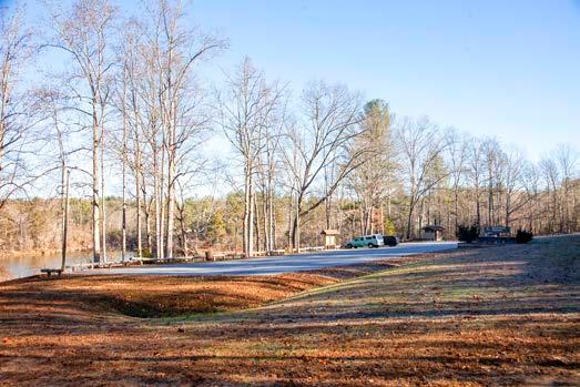
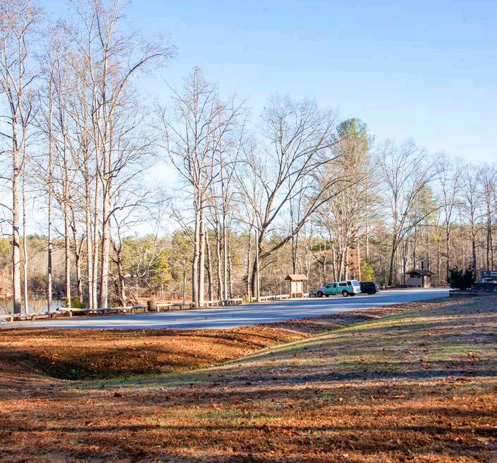
The eastern terminus of this planning section is located at the existing W. Kerr Scott Reservoir Visitor Center Trailhead. This is a developed trailhead with parking, restrooms, and a visitor center. The existing Bandit’s Roost and NC Hwy 268 trailheads provide parking only.
A proposed trailhead at Blood Creek Overlook would provide parking and a restroom. Due to its visible location on NC Hwy 268, this trailhead would also offer the opportunity to increase awareness of the OVT through signage and interpretive wayside exhibits. An additional trailhead could be located at Keowee Park and would offer parking, playground, picnic area, and a restroom.
The existing Warrior Creek trailhead features the OVT pumptrack, parking, and primary access to the Warrior Creek trail system. Additional parking improvements could be made at this crossing and existing trailhead. The Marley Ford and West Yadkin river accesses offer access to the Yadkin River and parking. Both access areas could potentially be developed as OVT trailheads.
CROSSINGS
One (1) minor bridge or culvert will be needed in this section at a small drainage between the Marley Ford and West Yadkin river accesses.
One (1) existing road crossing is located in this section across Campground Road, which provides access to Warrior Creek campground.
W. KERR SCOTT RESERVOIR TOM DULA RD
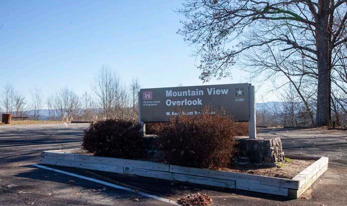
PHOTOS: (1) W Kerr Scott Visitors Center Trailhead. (2) Hwy 268 Trailhead. (3) Blood Creek Overlook. (4) Mountain View Overlook. (5) Warrior Creek Trailhead. (6) Marley Ford Access. (7) Unmaintained trail at West Yadkin River Acccess.
W. KERR SCOTT TRAIL SYSTEM
The W. Kerr Scott Reservoir trail system hosts over 40 miles of purpose-built single track mountain bike trail. Two of the three primary trail networks on the south side of the lake include sections of the OVNHT. A Memorandum of Understanding (MOU) between the USACE and the Northwest NC Mountain Bike Alliance allows volunteers to build and maintain the trails in the system. The W. Kerr Scott Reservoir trail system is recognized as a true backcountry riding experience and was designated as an IMBA EPIC trail in 2011. Source: USACE
PROPOSED TRAILS
TRAIL FEATURES
This planning section includes four (4) trailheads, and no major bridges, culverts, or road crossings.
TRAILHEADS
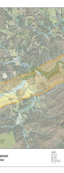
The preferred route in Section 2 extends for approximately 17 miles from the intersection of Tom Dula Road and NC Hwy 268 to the intersection of NC Hwy 268 and US Hwy 321. From the intersection of NC Hwy 268 and Tom Dula Road, the trail route utilizes a DOT side path along NC Hwy 268 until it reaches a parcel owned by a supportive landowner. At this location, a short section of the trail leaves the road and follows the river on a dual use trail before returning to NC Hwy 268.
The route continues as a DOT side path until it crosses the Yadkin River near its confluence with Buffalo Creek, where it departs NC Hwy 268. An existing certified natural surface trail follows the Yadkin River west across property owned by the Patterson School Foundation. It briefly returns to NC Hwy 268 as a DOT side path before aligning with the existing Happy Valley Greenway for approximately one mile. The route crosses the Yadkin River on a short bridge to Happy Valley Optimist Park before continuing west as a DOT side path along NC Hwy 268 until it reaches the intersection with US Hwy 321.
Two short spurs leave the OVT within this planning section to connect the preferred route with Fort Defiance and the WNC Sculpture Center at the Patterson School.
Three alternate routes in this section leave NC Hwy 268 and follow the Yadkin River across large parcels. However, landowner outreach along these alignments was unsuccessful, and additional outreach efforts will be necessary.
The first trailhead in this section is located on a parcel of undeveloped land between Champion and Bill Horton Roads owned by a willing landowner. The next three trailheads are located at points of interest in this section. Yadkin Valley Community Park, located on the south side of the Yadkin River across NC Hwy 268 from Fort Defiance, would serve as a local community trailhead. The Patterson School trailhead provides access to the WNC Sculpture Park and existing certified OVNHT. The existing Happy Valley Greenway trailhead serves as a trailhead on the western end of this trail segment.
CROSSINGS
Due to the preferred route primarily being located on a DOT sidepath next to NC Hwy 268, Yadkin River crossings would occur on DOT bridges, and additional road crossings are not necessary.
YADKIN VALLEY COMMUNITY PARK
FORT DEFIANCE TRAIL SPUR
YADKIN RIVER
o.v.n.h.t. preferred route
o.v.n.h.t. alternate route
FORT DEFIANCE
Fort Defiance is the only historic landmark located on this section of the OVT, but trail access is challenging due to tight parcelization of adjacent private property. A spur trail from the primary route along NC Hwy 268 that connects to Fort Defiance via the site’s entrance drive would provide an excellent connection opportunity.
PATTERSON SCHOOL
The former Patterson School is managed by the Patterson School Foundation and includes several historic structures located on the property. It is also home to the WNC Sculpture Center. A certified one-mile section of the OVNHT is located on the property next to the Yadkin River. A short spur trail from the school to the river would provide an opportunity for trail users to link these significant community assets.
SECTION 3
PROPOSED TRAILS
TRAIL FEATURES
This planning section includes one (1) trailhead, no major bridges, one (1) minor bridge or culvert, and three (3) road crossings.
Trailheads
BLAIRS FORK TRAILHEAD
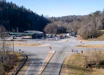
The preferred route in Section 3 extends for approximately 5.5 miles from the intersection of NC Hwy 268 and US Hwy 321 to the planned Blairs Fork Trailhead. This intersection serves as a significant challenge to the trail alignment. Pedestrian infrastructure improvements would create a safer crossing for trail users. Due to development of US Highway 321, a divided multi-lane highway on the historic trace, the proposed route leaves the historic corridor for a short distance to provide a safer and more desirable recreational experience. This route will limit exposure of trail users to high volume traffic and more closely represents the historic setting of the OVT.
After crossing US 321, the trail utilizes a DOT side path to parallel low volume paved roads as it travels south to the City of Lenoir. It begins by following Warrior Creek Road, turns right onto Setzers Creek Road, and then left onto Setzers Gap Road. The route continues south on Collettsville Road until just south of its intersection with Valway Road.
The trail leaves the road to utilize a former railroad corridor as a typical greenway that follows Valway Road and Blairs Fork until it reaches the planned Blairs Fork Trailhead on the corner of Valway Road and N. Main Street.
The only alternate route provided in this section is a DOT side path that follows Valway Road, offering an alternative to the former rail corridor near active industrial and commercial sites.
The planned Blairs Fork Trailhead is the only trailhead in this section. It was proposed in the Lenoir to Morganton OVT Plan and is currently in the pre-development stage. It serves as the southern terminus of this section of the OVT and would serve as the trailhead to the rail trail segment.
Crossings
The preferred route requires one (1) bridge in this planning section where the portion of the route following the rail corridor crosses Blairs Fork.
Three (3) road crossings are located within this planning section. Crossing #1 is the crossing of US Hwy 321. This is a significant crossing that would require pedestrian infrastructure. Crossing #2 is located on Valway Road where the former railroad corridor crosses the road. Crossing #3 is on the route crossing Blairs Fork Road within the former railroad corridor.
321 intersection. (2) Planned Blairs Fork Trailhead on N. Main St. (3) Valway Road and railroad corridor. 01
PHOTOS: (1) NC 268 and US
RAIL TRAIL AT BLAIRS FORK CHURCH AND TRAILHEAD
The abandoned railbed offers the opportunity for a rail trail alignment along Blairs Fork, providing a path of least resistance through this moderately developed portion of the historic corridor.
BLAIRS FORK BAPTIST CHURCH
BLAIRS FORK TRAILHEAD
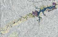
PLANNED BLAIRS FORK TRAILHEAD
In 2015, Caldwell County Pathways received a donation of a five-acre parcel that is anticipated to serve as the main trailhead for the OVT within Lenoir. A grant from the National Park Service in 2016 allowed Pathways to do survey work on the property and install a sign. Caldwell County Pathways partnered with the City of Lenoir, the NC State Extension Office, and the Caldwell Master Gardeners to prep the site and install landscaping to beautify the property and publicize the trail project.
CHAPTER 5 IMPLEMENTATION
Construction of the OVT from W. Kerr Scott Reservoir to Lenoir will be no small task. But with time, perseverance, and a little luck there is no doubt that a destinationquality trail is within grasp.
This chapter summarizes details regarding each planning section and establishes responsibilities and implementation priorities by focus area.
IN THIS CHAPTER
A. Implementation by Section and Responsibilities
B. Implementation Priorities by Focus Area
C. Trail Support Spectrum
IMPLEMENTATION DETAILS BY PLANNING SECTION
The table below provides an overall summary of key information associated with each planning section. Key opportunities provide valuable insight that may assist in determining priorities within each section. Key challenges include costly trail features or the need to acquire trail easements from private landowners. Most importantly, this table identifies key partners that must actively work in concert to fully implement plan recommendations.
IMPLEMENTATION DETAILS BY SECTON AND RESPONSIBILITY
WHERE TO START:
IMPLEMENTATION PRIORITIES BY FOCUS AREA
This plan recommends 28.9 new trail miles, crosses three political jurisdictions, and requires participation from multiple land managers. For this reason, implementation partners must focus their limited capacity, including time and money, to begin advancing plan implementation.
There are sections of existing local trails in this corridor that could easily become certified OVNHT and OVST. If OVNHT and OVST partners work with the National Park Service and North Carolina State Parks to certify existing trails, it would provide an easy win for OVT development. This plan generally recommends the OVNCST Friends Group and OVTA begin this process of certification for all existing local trails within the corridor. New trails can be built upon the foundation of these certified segments until all 330 miles are connected.
The Implementation Focus Areas Map illustrates recommended trail development focus areas within the broader context of the study corridor. These focus areas prioritize trail development that connects existing trail segments or is located on lands that are already managed by a public entity. Five suggested focus areas are presented to help partners target their efforts: 1) Hwy 268 to Horton Rd (Willing Landowner), 2) Patterson School, and 3) Valway Rd to Blairs Fork Trailhead Railbed.
Continued landowner engagement will be required for the preferred route to connect these focus areas in the future. Tight parcelization and narrow road rights-of-way present significant trail development challenges. Each government entity must work in tandem and with partners to successfully realize the complete OVT. Trail implementation does not have to occur in a specific, linear order according to each planning section. In fact, the priority areas for implementation are merely suggestions and are in no way intended to limit creativity or work in "lower" priority areas. Trail implementation is an art and requires the acumen to recognize and seize opportunities, whether related to funding, landowner willingness, or politics.
Focus
Hwy
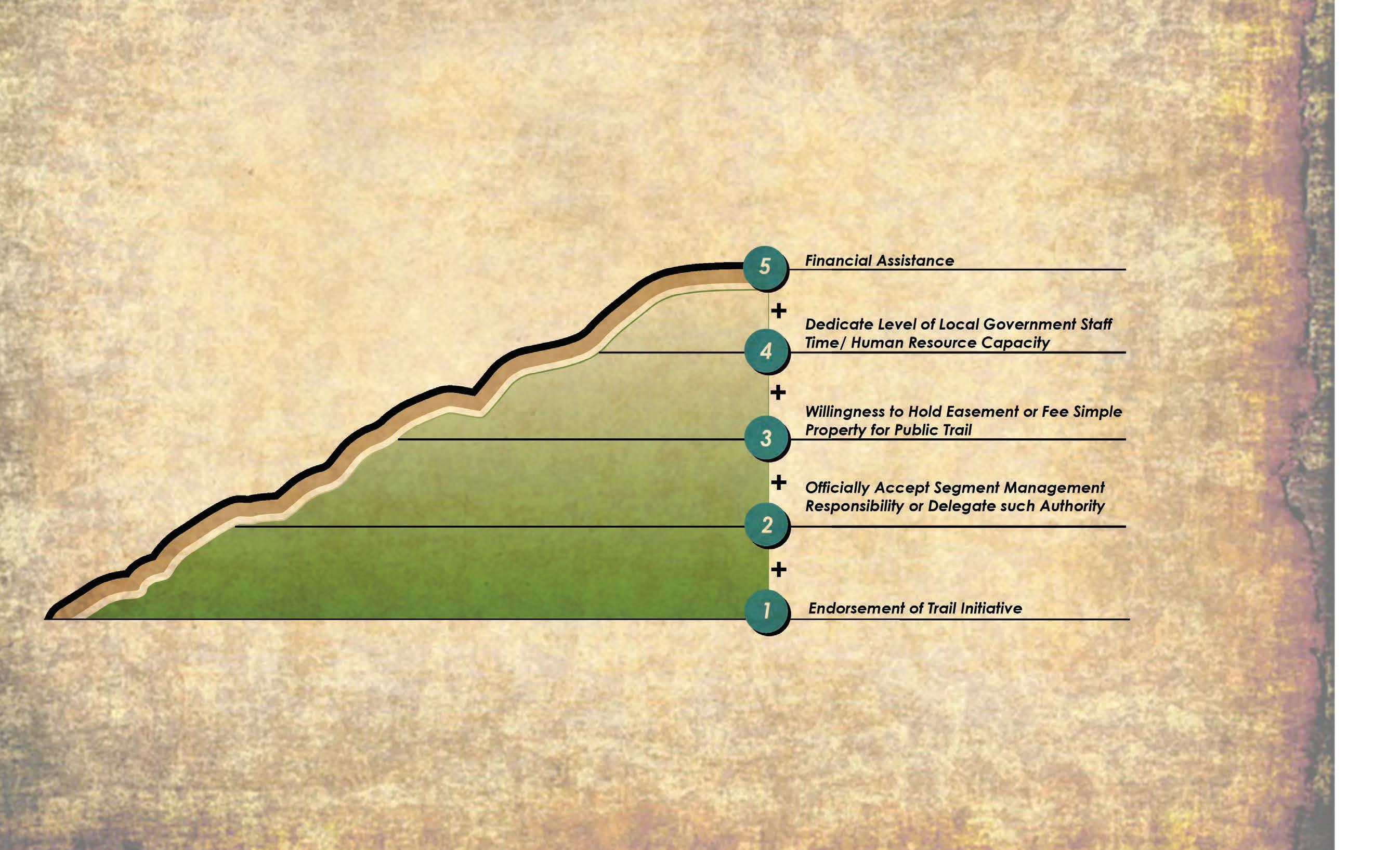
TRAIL SUPPORT SPECTRUM
Creating a destination-quality trail system requires a significant commitment from local governments, including
instead must leverage their funds to obtain support from grant agencies sympathetic to the creation of trails and the OVT. This particular section of the OVT enjoys support from many partners. Working together, local trail organizations and governments can have a far greater influence in convincing funding agencies of the merits of the trail than when acting alone.
The “Trail Support Spectrum” illustrates the steps local governments can take to support trail development in their jurisdictions.
TRAIL SUPPORT SPECTRUM
5
4
3
2
1
APPENDIX
(A1) BUDGET
(A2) LANDOWNER INVITATION
Dear Landowner:
Dear Wilkes and Caldwell County Neighbors,
The Overmountain Victory Trail Association has partnered with the National Park Service and local government leaders to explore the opportunity to create a public walking and biking trail that will connect Rutherfordton, North Carolina to Chesnee, South Carolina.
We hope that you will join the Overmountain Victory North Carolina State Trail - Friends group as we contribute to the lasting history of North Carolina. Through partnerships with the National Park Service, North Carolina State Parks, local governments, and the Overmountain Victory Trail Association, the OVNCST-Friends are working to create a trail that will connect W. Kerr Scott Reservoir to Lenoir, NC. This exciting possibility will help link Virginia, Tennessee, North Carolina, and South Carolina where the 313-mile Overmountain Victory Trail spans.
This trail will celebrate the march of the Overmountain Men who won a major Revolutionary War battle in 1780 at Kings Mountain, South Carolina. The patriot victory is considered a turning point in the war that resulted in American independence. The trail will help preserve this history.
The project planning team has been working to identify areas where the trail would be feasible. A broad study area, as shown on the enclosed map, was evaluated for potential routes. After months of analysis, your property has been identified as being located within or near the historic Overmountain corridor where the trail could potentially be constructed. Without the voluntary willingness of landowners, the trail route will either be relocated or not constructed.
In September 1780, nearly 300 men walked over or very near to your property on their way to the victorious Battle of Kings Mountain. This was the turning point in the Revolutionary War that resulted in American independence. We intend to make sure the legacy of their bravery and sacrifice are remembered for generations to come by engaging people directly with the trail.
Please visit the project website, www.OVTplan.com, to learn more and view the project video.
Please take a look at the enclosed map that shows the one-mile wide historic corridor that stretches between W. Kerr Scott Reservoir, and Lenoir, NC. Analysis of the historic route has shown that the trail corridor falls within, or very close to your property, and our project planning team has identified areas where establishing a trail within this corridor is feasible.
You are invited to discuss this project with representatives from the National Park Service and trail planners during one of two special landowner meetings:
Wednesday, October 2, 2019 at 6:00 pm Thursday, October 3, 2019 at 6:00 pm
Cowpens National Battlefield Rutherford County Office Building 4001 Chesnee Hwy 289 North Main Street Gaffney, SC 29341 Rutherfordton, NC 28139
We would greatly appreciate the opportunity to share more information with you and explore the possibility that you might like to participate in this unique historical project. Participation is completely voluntary, and please be assured that no trail will be developed on private property without the landholder’s full approval and support.
Please visit the project website, www.OVTplan.com, to learn more.
If you plan to attend the meeting, or if you cannot attend but would like to discuss the project and your potential interest in providing for the trail on your property, please let us know by using the contact information below. Thank you.
We invite you to discuss this project with representatives from the Overmountain Victory Trail Planning Committee, National Park Service, and trail planners during one of two special landowner meetings. Attendance is not a commitment to the project.
On behalf of,
Overmountain Victory Trail Planning Committee
Monday, March 18, 2024 at 6:00 pm Tuesday, October 19, 2024 at 6:00 pm Wilkes County Center - Meeting Room C Lenoir Moose Lodge 416 Executive Dr, 1100 Moose Lodge Rd. Wilkesboro Lenoir
RSVP Email: info@OVTplan.com Phone: 828.386.1866
County Commissioners
Bryan A. King, Chairman Eddie Holland
If you plan to attend the meeting or if you cannot attend but would like to discuss the project and your potential interest in allowing the trail to be developed on your property, please contact Starli McDowell, Executive Director - OVNCST - Friends, using the email or phone number below. Thank you.
Alan Toney, Vice Chairman Greg Lovelace
Michael Benfield
On behalf of the Overmountain Victory Trail Planning Committee, Email: starli.ovncst@gmail.com Phone: 828-773-0814
Steve Garrison, County Manager
Hazel S. Haynes, Clerk to the Board
Richard Williams, County Attorney
(A3) LANDOWNER INTEREST SURVEY
Please
Ο Somewhat interested and welcome further discussions Ο Very interested
(A4) FUNDING SOURCES
NORTH CAROLINA
(A5) THE NATIONAL TRAILS SYSTEM ACT
THE NATIONAL TRAILS SYSTEM ACT
(P.L. 90 - 543, as amended through P.L. 116 -9 , Ma rch 12, 2019 ) (as found in United States Code , Vol. 16, Sections 1241 - 1251)
AN ACT
To establish a national trails system, and for other purposes.
Be it enacted by the Senate and House of Representatives of the United States of America in Congress assembled,
SHORT TITLE
SECTION 1. [16USC1241] This Act may be cited as the "National Trails System Act".
STATEMENT OF POLICY
SEC. 2. [16USC1241] (a) In order to provide for the ever-increasing outdoor recreation needs of an expanding population and in order to promote the preservation of, public access to, travel within, and enjoyment and appreciation of the open-air, outdoor areas and historic resources of the Nation, trails should be established (i) primarily, near the urban areas of the Nation, and (ii) secondarily, within scenic areas and along historic travel routes of the Nation which are often more remotely located.
(b) The purpose of this Act is to provide the means for attaining these objectives by instituting a national system of recreation, scenic and historic trails, by designating the Appalachian Trail and the Pacific Crest Trail as the initial components of that system, and by prescribing the methods by which, and standards according to which, additional components may be added to the system.
(c) The Congress recognizes the valuable contributions that volunteers and private, nonprofit trail groups have made to the development and maintenance of the Nation's trails. In recognition of these contributions, it is further the purpose of this Act to encourage and assist volunteer citizen involvement in the planning, development, maintenance, and management, where appropriate, of trails.
NATIONAL TRAILS SYSTEM
SEC. 3. [16USC1242] (a) The national system of trails shall be composed of the following:
(1) National recreation trails, established as provided in section 4 of this Act, which will provide a variety of outdoor recreation uses in or reasonably accessible to urban areas.
(2) National scenic trails, established as provided in section 5 of this Act, which will be extended trails so located as to provide for maximum outdoor recreation potential and for the conservation and enjoyment of the nationally significant scenic, historic, natural, or cultural qualities of the areas through which such trails may pass. National scenic trails may be located so as to represent desert, marsh, grassland, mountain, canyon, river, forest, and other areas, as well as landforms which exhibit significant characteristics of the physiographic regions of the Nation.
(3) National historic trails, established as provided in section 5 of this Act, which will be extended trails which follow as closely as possible and practicable the original trails or routes of travel of national historic significance. Designation of such trails or routes shall be continuous, but the established or developed trail, and the acquisition thereof, need not be continuous onsite. National historic trails shall have as their purpose the identification and protection of the historic route and its historic remnants and artifacts for public use and enjoyment. Only those selected land and water based components of a historic trail which are on federally owned lands and which meet the national historic trail criteria established in this Act are included as Federal protection components of a national historic trail. The appropriate Secretary may certify other lands as protected segments of an historic trail upon application from State or local governmental agencies or private interests involved if such segments meet the national historic trail criteria established in this Act and such criteria supplementary thereto as the appropriate Secretary may prescribe, and are administered by such agencies or interests without expense to the United States.
(4) Connecting or side trails, established as provided in section 6 of this Act, which will provide additional points of public access to national recreation, national scenic or national historic trails or which will provide connections between such trails.
The Secretary of the Interior and the Secretary of Agriculture, in consultation with appropriate governmental agencies and public and private organizations, shall establish a uniform marker for the national trails system.
(b) For purposes of this section, the term “extended trails” means trails or trail segments which total at least one hundred miles in length, except that historic trails of less than one hundred miles may be designated as extended trails. While it is desirable that extended trails be continuous, studies of such trails may conclude that it is feasible to propose one or more trail segments which, in the aggregate, constitute at least one hundred miles in length.
NATIONAL RECREATION TRAILS
SEC. 4. [16USC1243] (a) The Secretary of the Interior, or the Secretary of Agriculture where lands administered by him are involved, may establish and designate national recreation trails, with the consent of the Federal agency, State, or political subdivision having jurisdiction over the lands involved, upon finding that
(i ) such trails are reasonably accessible to urban areas, and, or
(ii) such trails meet the criteria established in this Act and such supplementary criteria as he may prescribe.
(b) As provided in this section, trails within park, forest, and other recreation areas administered by the Secretary of the Interior or the Secretary of Agriculture or in other federally administered areas may be established and designated as "National Recreation Trails" by the appropriate Secretary and, when no Federal land acquisition is involved
(i) trails in or reasonably accessible to urban areas may be designated as "National Recreation Trails" by the appropriate Secretary with the consent of the States, their political subdivisions, or other appropriate administering agencies;
(ii) trails within park, forest, and other recreation areas owned or administered by States may be designated as "National Recreation Trails" by the appropriate Secretary with the consent of the State; and
(iii) trails on privately owned lands may be designated “National Recreation Trails” by the appropriate Secretary with the written consent of the owner of the property involved.
NATIONAL SCENIC AND NATIONAL HISTORIC TRAILS
SEC. 5. [16USC1244] (a) National scenic and national historic trails shall be authorized and designated only by Act of Congress. There are hereby established the following National Scenic and National Historic Trails:
(1) The Appalachian National Scenic Trail, a trail of approximately two thousand miles extending generally along the Appalachian Mountains from Mount Katahdin, Maine, to Springer Mountain, Georgia. Insofar as practicable, the right-of-way for such trail shall comprise the trail depicted on the maps ident ified as "Nationwide System of Trails, Proposed Appalachian Trail, NST -AT -101-May 1967", which shall be on file and available for public inspection in the office of the Director of the National Park Service. Where practicable, such rights-of-way shall include lands protected for it under agreements in effect as of the date of enactment of this Act, to which Federal agencies and States were parties. The Appalachian Trail shall b e administered primarily as a footpath by the Secretary of the Interior, in consultation with the Secretary of Agriculture.
(2) The Pacific Crest National Scenic Trail, a trail of approximately two thousand three hundred fifty miles, extending from the Mexican-California border northward generally along the mountain ranges of the west coast States to the Canadian-Washington border near Lake Ross, following the route as generally depicted on the map, identified as "Nationwide System of Trails, Proposed Pacific Crest Trail, NST -PC-103-May 1967" which shall be on file and available for public inspection in the office of the Chief of the Forest Service. The Pacific Crest Trail shall be administered by the Secretary of Agriculture, in consultation with the Secretary of the Interior.
(3) The Oregon National Historic Trail, a route of approximately two thousand miles extending from near Independence, Missouri, to the vicinity of Portland, Oregon, following a route as depicted on maps identified as “Primary Route of the Oregon Trail 1841-1848”, in the Department of the Interior's Oregon Trail study report dated April 1977, and which shall be on file and available for public inspection in the office of the Director of the National Park Service. The trail shall be administered by the Secretary of the Interior. No land or interest in land outside the exterior boundaries of any federally administered
area may be acquired by the Federal Government for the trail except with the consent of the owner of the land or interest in land. The authority of the Federal Government to acquire fee title under this paragraph shall be limited to an average of not more than 1/4 mile on either side of the trail.
(4) The Mormon Pioneer National Historic Trail, a route of approximately one thousand three hundred miles extending from Nauvoo, Illinois, to Salt Lake City, Utah, following the primary historical route of the Mormon Trail as generally depicted on a map, identified as, “Mormon Trail Vicinity Map, figure 2” in the Department of the Interior Mormon Trail study report dated March 1977, and which shall be on file and available for public inspection in the office of the Director, National Park Service, Washington, D.C. The trail shall be administered by the Secretary of the Interior. No land or interest in land outside the exterior boundaries of any federally administered area may be acquired by the Federal Government for the trail except with the consent of the owner of the land or interest in land. The authority of the Federal Government to acquire fee title under this paragraph shall be limited to an average of not more than 1/4 mile on either side of the trail.
(5) The Continental Divide National Scenic Trail, a trail of approximately thirty-one hundred miles, extending from t he Montana-Canada border to the New Mexico-Mexico border, following the approximate route depicted on the map, identified as “Proposed Continental Divide National Scenic Trail” in the Department of the Interior Continental Divide Trail study report dated March 1977 and which shall be on file and available for public inspection in the office of the Chief, Forest Service, Washington, D.C. The Continental Divide National Scenic Trail shall be administered by the Secretary of Agriculture in consultation with the Secretary of the Interior. Notwithstanding the provisions of section 7(c), the use of motorized vehicles on roads which will be designated segments of the Continental Divide National Scenic Trail shall be permitted in accordance with regulations prescribed by the appropriate Secretary. No land or interest in land outside the exterior boundaries of any federally administered area may be acquired by the Federal Government for the trail except with the consent of the owner of the land or interest in land. The authority of the Federal Government to acquire fee title under this paragraph shall be limited to an average of not more than 1/4 mile on either side of the trail.
(6) The Lewis and Clark National Historic Trail, a trail of approximately 4,900 miles, ext ending from the Ohio River in Pittsburgh, Pennsylvania, to the mouth of the Columbia River in Oregon, following the outbound and inbound routes of the Lewis and Clark Expedition depicted on the map entitled ‘Lewis and Clark National Historic Trail Aut horized Trail Including Proposed Eastern Legacy Extension’, dated April 2018, and numbered 648/143721. The map shall be on file and available for public inspection in the office of the Director, National Park Service, Washington, D.C. The trail shall be administered by the Secretary of the Interior. No land or interest in land outside the exterior boundaries of any federally administered area may be acquired by the Federal Government for the trail except with the consent of the owner of the land or interest in land. The authority of the Federal Government to acquire fee title under this paragraph shall be limited to an average of not more than 1/4 mile on either side of the trail.
(7) The Iditarod National Historic Trail, a route of approximately two thousand miles extending from Seward, Alaska, to Nome, Alaska, following the routes as depicted on maps identified as 'Seward-Nome Trail', in the Department of the Interior's study report entitled 'The Iditarod Trail (Seward-Nome Route) and other Alaskan Gold Rush Trails' dated September 1977. The map shall be on file and available for public inspection in the office of the Director, National Park Service, Washington, D.C. The trail shall be administered by the Secretary of the Interior. No land or interest in land outside the exterior boundaries of any federally administered area may be acquired by the Federal Government
(A5) THE NATIONAL TRAILS SYSTEM ACT
for the trail except with the consent of the owner of the land or interest in land. The authority of the Federal Government to acquire fee title under this paragraph shall be limited to an average of not more than 1/4 mile on either side of the trail.
(8) The North Country National Scenic Trail, a trail of approximately 4,600miles, extending from the Appalachian Trail in Vermont to the vicinity of Lake Sakakawea in North Dakota, following the approximate route depicted on the map identified ‘North Country National Scenic Trail, Authorized Route’, dated February 2014, and numbered 649/116870. The map shall be on file and available for public inspection in the office of the Director, National Park Service, Washington, District of Columbia. The trail shall be administered by the Secretary of the Interior. No land or interest in land outside the exterior boundaries of any federally administer ed area may be acquired by the Federal Government for the trail except with the consent of the owner of the land or interest in land.
(9) The Overmountain Victory National Historic Trail, a system totaling approximately two hundred seventy-two miles of trail with routes from the mustering point near Abingdon, Virginia, to Sycamore Shoals (near Elizabethton, Tennessee); from Sycamore Shoals to Quaker Meadows (near Morganton, North Carolina); from the mustering point in Surry County, North Carolina, to Quaker Meadows; and from Quaker Meadows to Kings Mountain, South Carolina, as depicted on the map identified as Map 3 Historic Features 1780 in the draft study report entitled 'Overmountain Victory Trail' dated December 1979. The map shall be on file and available for public inspection in the Office of the Director, National Park Service, Washington, District of Columbia. The trail shall be administered by the Secretary of the Interior.
(10) The Ice Age National Scenic Trail, a trail of approximately one thousand miles, extending from Door County, Wisconsin, to Interstate Park in Saint Croix County, Wisconsin, generally following the route described in "On the Trail of the Ice Age A Hiker's and Biker's Guide to Wisconsin's Ice Age National Scientific Res erve and Trail", by Henry S. Reuss, Member of Congress, dated 1980. The guide and maps shall be on file and available for public inspection in the Office of the Director, National Park Service, Washington, District of Columbia. Overall administration of the trail shall be the responsibility of the Secretary of the Interior pursuant to section 5(d) of this Act. The State of Wisconsin, in consultation with the Secretary of the Interior, may, subject to the approval of the Secretary, prepare a plan for the management of the trail which shall be deemed to meet the requirements of section 5(e) of this Act. Notwithstanding the provisions of section 7(c), snowmobile use may be permitted on segments of the Ice Age National Scenic Trail where deemed appropriate by the Secretary and the managing authority responsible for the segment. No land or interest in land outside the exterior boundaries of any federally administered area may be acquired by the Federal Government for the trail except with the consent of the owner of the land or interest in land.
(11) The Potomac Heritage National Scenic Trail, a corridor of approximately seven hundred and four miles following the route as generally depicted on the map identified as 'National Trails System, Proposed Potomac Heritage Trail' in 'The Potomac Heritage Trail', a report prepared by the Department of the Interior and dated December 1974, except that no designation of the trail shall be made in the State of West Virginia. The map shall be on file and available for public inspection in the office of the Director of the National Park Service, Washington, District of Columbia. The trail shall initially consist of only those segments of the corridor located within the exterior boundaries of federally administered areas. The trail shall be administered by the Secretary of the Interior. No land or interest in land outside the exterior boundaries of any federally administered area may be acquired by the Federal Government for the trail except with the consent of the owner of the land or interest in land.
(12) The Natchez Trace National Scenic Trail, a trail system of approximately six hundred and ninety-four miles extending from Nashville, Tennessee, to Natchez, Mississippi, as depicted on the map entitled “Concept Plan, Natchez Trace Trails Study” in “The Natchez Trace”, a report prepared by the Department of the Interior and dated August 1979. The map shall be on file and available for public inspection in the office of the Director of the National Park Service, Department of the Interior, Washington, District of Columbia. The trail shall be administered by the Secretary of the Interior.
(13) The Florida National Scenic Trail, a route of approximately thirteen hundred miles extending through the State of Florida as generally depicted in “The Florida Trail”, a national scenic trail study draft report prepared by the Department of the Interior and dated February 1980. The report shall be on file and available for public inspection in the office of the Chief of the Forest Service, Washington, District of Columbia. No lands or interests therein outside the exterior boundaries of any federally administered area may be acquired by the Federal Government for the Florida Trail except with the consent of the owner thereof. The Secretary of Agriculture may designate lands outside of federally administered areas as segments of the trail, only upon application from the States or local governmental agencies involved, if such segments meet the criteria established in this Act and are administered by such agencies without expense to the United States. The trail shall be administered by the Secretary of Agriculture.
(14) The Nez Perce National Historic Trail, a route of approximately eleven hundred and seventy miles extending from t he vicinity of Wallowa Lake, Oregon, to Bear Paw Mountain, Montana, as generally depicted in “Nez Perce (Nee-Me-Poo) Trail Study Report” prepared by the Department of Agriculture and dated March 1982. The report shall be on file and available for public inspection in the Office of the Chief of the Forest Service, Washington, District of Columbia. The trail shall be administered by the Secretary of Agriculture. So that significant route segments and sites recognized as associated with the Nez Perce Trail may be distinguished by suitable markers, the Secretary of Agriculture is authorized to accept the donation of suitable markers for placement at appropriate locations. Any such markers associated with the Nez Perce Trail which are to be located on lands administered by any other department or agency of the United States may be placed on such lands only with the concurrence of the head of such department or agency. No land or interest in land outside the exterior boundaries of any federally administered area may be acquired by the Federal Government for the trail except with the consent of the owner of the land or interest in land. The authority of the Federal Government to acquire fee title under this paragraph shall be limited to an average of not more than 1/4 mile on either side of the trail.
(15) The Santa Fe National Historic Trail, a trail of approximately 950 miles from a point near Old Franklin, Missouri, through Kansas, Oklahoma, and Colorado to Santa Fe, New Mexico, as generally depicted on a map entitled "The Santa Fe Trail" contained in the Final Report of the Secretary of the Interior pursuant to subsection (b) of this section, dated July 1976. The map shall be on file and available for public inspection in the office of the Director of the National Park Service, Washington, District of Columbia. The trail shall be administered by the Secretary of the Interior. No lands or interests therein outside the exterior boundaries of any federally administered area may be acquired by the Federal Government for the Santa Fe Trail except with the consent of the owner thereof. Before acquiring any easement or entering into any cooperative agreement with a private landowner with respect to the trail, the Secretary shall notify the landowner of the potential liability, if any, for injury to the public resulting from physical conditions which may be on the landowner's land. The United States shall not be held liable by reason of such notice or failure to provide such notice to the landowner. So that significant route segments and sites recognized as associated with the Santa Fe Trail may be distinguished by suitable
markers, the Secretary of the Interior is authorized to accept the donation of suitable markers for placement at appropriate locations.
(16)(A) The Trail of Tears National Historic Trail, a trail consisting of water routes and overland routes traveled by the Cherokee Nation during its removal from ancestral lands in the East to Oklahoma during 1838 and 1839, generally located within the corridor described through portions of Georgia, North Carolina, Alabama, Tennessee, Kentucky, Illinois, Missouri, Arkansas, and Oklahoma in the final report of the Secretary of the Interior prepared pursuant to subsection (b) of this section entitled "Trail of Tears" and dated June 1986. Maps depicting the corridor shall be on file and available for public inspection in the Office of the National Park Service, Department of the Interior. The trail shall be administered by the Secretary of the Interior. No lands or interests therein outside the exterior boundaries of any federally administered area may be acquired by the Federal Government for the Trail of Tears except with the consent of the owner thereof.
(B) In carrying out his responsibilities pursuant to sections 5(f) and 7(c) of this Act, the Secretary of the Interior shall give careful consideration to the establishment of appropriate interpretive sites for the Trail of Tears in the vicinity of Hopkinsville, Kentucky, Fort Smith, Arkansas, Trail of Tears State Park, Missouri, and Tahlequah, Oklahoma.
(C) In addition to the areas otherwise designated under this paragraph, the following routes and land components by which the Cherokee Nation was removed to Oklahoma are components of the Trail of Tears National Historic Trail, as generally described in the environmentally preferred alternative of the November 2007 Feasibility Study Amendment and Environmental Assessment for Trail of Tears National Historic Trail:
(i) The Benge and Bell routes.
(ii) The land components of the designated water routes in Alabama, Arkansas, Oklahoma, and Tennessee.
(iii) The routes from the collection forts in Alabama, Georgia, North Carolina, and Tennessee to the emigration depots.
(iv) The related campgrounds located along the routes and land components described in clauses (i) through (iii).
(D) The Secretary may accept donations for the Trail from private, nonprofit, or tribal organizations. No lands or interests in lands outside the exterior boundaries of any federally administered area may be acquired by the Federal Government for the Trail of Tears National Historic Trail except with the consent of the owner thereof.
(17) The Juan Bautista de Anza National Historic Trail, a trail comprising the overland route traveled by Captain Juan Bautista de Anza of Spain during the years 1775 and 1776 from Sonora, Mexico, to the vicinity of San Francisco, California, as generally described in the report of the Department of Interior prepared pursuant to the subsection (b) entitled 'Juan Bautista de Anza National Trail Study, Feasibility Study and Environmental Assessment' and dated August, 1986. A map generally depicting the trail shall be on file and available for public inspection in the Office of the Director of the National Park Service, Washington, District of Columbia. The trail shall be administered by the Secretary of Interior. No lands or interest therein outside the exterior boundaries of any federally administered area may be acquired by the Federal Government for the Juan Bautista de Anza National Historic Trail without the consent of the owner thereof. In implementing this paragraph, the Secretary shall encourage volunteer
trail groups to participate in the development and maintenance of the trail.
(18) The California National Historic Trail, a route of approximately five thousand seven hundred miles, including all routes and cutoffs, extending from Independence and Saint Joseph, Missouri, and Council Bluffs, Iowa, to various points in California and Oregon, as generally described in the report of the Department of the Interior prepared pursuant to subsection (b) of this section entitled "California and Pony Express Trails, Eligibility/Feasibility Study/Environmental Assessment" and dated September 1987. A map generally depicting the route shall be on file and available for public inspection in the Office of the National Park Service, Department of the Interior. The trail shall be administered by the Secretary of the Interior. No lands or interests therein outside the exterior boundaries of any federally administered area may be acquired by the United States for the California National Historic Trail except with the consent of the owner thereof.
(19) The Pony Express National Historic Trail, a route of approximately one thousand nine hundred miles, including the original route and subsequent route changes, extending from Saint Joseph, Missouri, to Sacramento, California, as generally described in the report of the Department of the Interior prepared pursuant to subsection (b) of this section entitled "California and Pony Express Trails, Eligibility/Feasibility Study/Environmental Assessment" and dated September 1987. A map generally depicting the route shall be on file and available for public inspection in the Office of the National Park Service, Department of the Interior. The trail shall be administered by the Secretary of the Interior. No lands or interests therein outside the exterior boundaries of any federally administered area may be acquired by the United States for the Pony Express National Historic Trail except with the consent of the owner thereof.
[Related language from P.L. 102-328, section 2: The Secretary of the Interior (hereinafter referred to as the Secretary) shall undertake a study of the land and water route used to carry mail from Sacramento to San Francisco, California, to determine the feasibility and suitability of designation of such route as a component of the Pony Express National Historic Trail designated by section 1 of this Act. Upon completion of the study, if the Secretary determines such a route is a feasible and suitable addition to the Pony Express National Historic Trail, the Secretary shall designate the route as a component of the Pony Express National Historic Trail. The Secretary shall publish notice of such designation in the Federal Register and shall submit the study along with his findings to the Committee on Interior and Insular Affairs of the United States House of Representatives and the Committee on Energy and Natural Resources of the United States Senate.]
(20) The Selma to Montgomery National Historic Trail, consisting of 54 miles of city streets and United States Highway 80 from Brown Chapel A.M.E. Church in Selma to the State Capitol Building in Montgomery, Alabama, traveled by voting rights advocates during March 1965 to dramatize the need for voting rights legislation, as generally described in the report to the Secretary of the Interior prepared pursuant to subsection (b) of this section entitled "Selma to Montgomery" and dated April, 1993. Maps depicting the route shall be on file and available for public inspection in the Office of the National Park Service, Department of the Interior. The trail shall be administered in accordance with this Act, including section 7(h). The Secretary of the Interior, acting through the National Park Service, which shall be the lead Federal agency, shall cooperate with other Federal, State and local authorities to preserve historic sites along the route, including (but not limited to) the Edmund Pettus Bridge and the Brown Chapel A.M.E. Church.
(21) El Camino Real de tierra adentro –
(A5) THE NATIONAL TRAILS SYSTEM ACT
(A) El Camino Real de Tierra Adentro (the Royal Road of the Interior) National Historic Trail, a 404 mile long trail from Rio Grande near El Paso, Texas to San Juan Pueblo, New Mexico, as generally depicted on the maps entitled “United States Route: El Camino Real de Tierra Adentro,” contained in the report prepared pursuant to subsection (b) entitled “National Historic Trail Feasibility Study and Environmental Assessment: El Camino Real de Tierra Adentro, Texas-New Mexico,” dated March 1997.
(B) MAP - A map generally depicting the trail shall be on file and available for public inspection in the Office of the National Park Service, Department of the Interior.
(C) ADMINISTRATION - The Trail shall be administered by the Secretary of the Interior.
(D) LAND ACQUISTION - No lands or interests therein outside the exterior boundaries of any federally administered area may be acquired by the Federal Gover nment for El Camino Real de Tierra Adentro except with the consent of the owner thereof.
(E) VOLUNTEER GROUPS; CONSULTATION - The Secretary of the Interior shall (i) encourage volunteer groups to participate in the development and maintenance of the trail; and (ii) consult with other affected Federal, State, local governmental, and tribal agencies in the administration of the trail.
(F) COORDINATION OF ACTIVITIES -The Secretary of the Interior may coordinate with United States and Mexican public and non-governmental organizations, academic institutions, and in consultation with the Secretary of State, the government of Mexico and its political subdivisions, for the purpose of exchanging trail information and research, fostering trail preservation and education programs, providing technical assistance, and working to establish an international historic trail with complementary preservation and education programs in each nation.
(22) Ala Kahakai National Historic Trail
(A) IN GENERAL - The Ala Kahakai National Historic Trail (the Trail by the Sea), a 175 mile long trail extending from ‘Upola Point on the north tip of Hawaii Island down the west coast of the Island around Ka Lae to the east boundary of Hawaii Volcanoes National Park at the ancient shoreline temple known as “Waha’ula,” as generally depicted on the map entitled “Ala Kahakai Trail,” contained in the report prepared pursuant to subsection (b) entitled “Ala Kahakai National Trail Study and Environmental Impact Statement,” dated January, 1998.
(B) MAP - A map generally depicting the trail shall be on file and available for public inspection in the Office of the National Park Service, Department of the Interior.
(C) ADMINISTRATION - The trail shall be administered by the Secretary of the Interior.
(D) LAND ACQUISTION - No land or interest in land outside the exterior boundaries of any federally administered area may be acquired by the United States for the trail except with the consent of the owner of the land or interest in land.
-
(E) PUBLIC PARTICIPATION; CONSULTATION - The Secretary of the Interior shall-
(i) encourage communities and owners of land along the trail, native Hawaiians, and volunteer trail groups to participate in the planning, development, and maintenance of the trail; and
(ii) consult with affected Federal, State, and local agencies, native Hawaiian groups, and landowners in the administration of the trail.
(23) Old Spanish National Historic Trail
(A) IN GENERAL – The Old Spanish National Historic Trail, an approximately 2,700 mile long trail extending from Santa Fe, New Mexico, to Los Angeles, California, that served as a major trade route between 1829 and 1848, as generally depicted on the maps numbered 1 through 9, as contained in the report entitled ‘Old Spanish Trail National Historic Trail Feasibility Study,’ dated July 2001, including the Armijo Route, Northern Route, North Branch, and Mojave Road.
(B) MAP – A map generally depicting the trail shall be on file and available for public inspection in the appropriate offices of the Department of the Interior.
(C ) ADMINISTRATION – The trail shall be administered by the Secretary of the Interior (referred to in this paragraph as the ‘Secretary’).
(D) LAND ACQUISITION – The United States shall not acquire for the trail any land or interest in land outside the exterior boundary of any federally-managed area without the consent of the owner of the land or interest in land.
(E) CONSULTATION – The Secretary shall consult with other Federal, State, local, and tribal agencies in the administration of the trail.
(F) ADDITIONAL ROUTES – The Secretary may designate additional routes to the trail if -
(i) the additional routes were included in the Old Spanish Trail National Historic Trail Feasibility Study, but were not recommended for designation as a national historic trail; and
(ii) the Secretary determines that the additional routes were used for trade and commerce between 1829 and 1848.
(24) El Camino Real De Los Tejas National Historic Trail
(A) IN GENERAL - El Camino Real de los Tejas (the Royal Road to the Tejas) National Historic Trail, a combination of historic routes (including the Old San Antonio Road) totaling approximately 2,580 miles, extending from the Rio Grande near Eagle Pass and Laredo, Texas, to Natchitoches, Louisiana, as generally depicted on the map entitled `El Camino Real de los Tejas' contained in the report entitled `National Historic Trail Feasibility Study and Environmental Assessment: El Camino Real de los Tejas, TexasLouisiana', dated July 1998.
(B) MAP - A map generally depicting the trail shall be on file and available for public inspection in the appropriate offices of the National Park Service.
(C) ADMINISTRATION
(i) The Secretary of the Interior (referred to in this paragraph as `the Secretary') shall administer the trail.
(ii) The Secretary shall administer those portions of the trail on non-Federal land only with the consent of the owner of such land and when such trail portion qualifies for certification as an officially established component of the trail, consistent with section 3(a)(3). An owner's approval of a certification agreement shall satisfy the consent requirement. A certification agreement may be terminated at any time.
(iii) The designation of the trail does not authorize any person to enter private property without the consent of the owner.
(D) CONSULTATION - The Secretary shall consult with appropriate State and local agencies in the planning and development of the trail.
(E) COORDINATION OF ACTIVITIES - The Secretary may coordinate with United States and Mexican public and nongovernmental organizations, academic institutions, and, in consultation with the Secretary of State, the Government of Mexico and its political subdivisions, for the purpose of exchanging trail information and research, fostering trail preservation and educational programs, providing technical assistance, and working to establish an international historic trail with complementary preservation and education programs in each nation.
(F) LAND ACQUISITION- The United States shall not acquire for the trail any land or interest in land outside the exterior boundary of any federally-administered area without the consent of the owner of the land or interest in land.
(25) Captain John Smith Chesapeake National Historic Trail
(A) IN GENERAL- The Captain John Smith Chesapeake National Historic Trail, a series of water routes extending approximately 3,000 miles along the Chesapeake Bay and the tributaries of the Chesapeake Bay in the States of Virginia, Maryland, and Delaware, and in the District of Columbia, that traces the 1607-1609 voyages of Captain John Smith to chart the land and waterways of the Chesapeake Bay, as generally depicted on the map entitled Captain John Smith Chesapeake National Historic Trail Map MD, VA, DE, and DC, numbered P-16/8000 (CAJO), and dated May 2006.
(B) MAP- The map referred to in subparagraph (A) shall be on file and available for public inspection in the appropriate offices of the National Park Service.
(C) ADMINISTRATION- The trail shall be administered by the Secretary of the Interior-
(i) in coordination with (I) the Chesapeake Bay Gateways and Watertrails Network authorized under the Chesapeake Bay Initiative Act of 1998 (16 U.S.C. 461 note; 112 Stat. 2961); and
(II) the Chesapeake Bay Program authorized under section 117 of the Federal Water Pollution Control Act (33 U.S.C. 1267); and
(ii) in consultation with
(I) other Federal, State, tribal, regional, and local agencies; and (II) the private sector.
(D) LAND ACQUISITION- The United States shall not acquire for the trail any land or interest in land outside the exterior boundary of any federally-managed area without the consent of the owner of the land or interest in land.
(26) Star-Spangled Banner National Historic Trail-
(A) IN GENERAL- The Star-Spangled Banner National Historic Trail, a trail consisting of water and overland routes totaling approximately 290 miles, extending from Tangier Island, Virginia, through southern Maryland, the District of Columbia, and northern Virginia, in the Chesapeake Bay, Patuxent River, Potomac River, and north to the Patapsco River, and Baltimore, Maryland, commemorating the Chesapeake Campaign of the War of 1812 (including the British invasion of Washington, District of Columbia, and its associated feints, and the Battle of Baltimore in summer 1814), as generally depicted on the map titled `Star-Spangled Banner National Historic Trail', numbered T02/80,000, and dated June 2007.
(B) MAP- The map referred to in subparagraph (A) shall be maintained on file and available for public inspection in the appropriate offices of the National Park Service.
(C) ADMINISTRATION- Subject to subparagraph (E)(ii), the trail shall be administered by the Secretary of the Interior.
(D) LAND ACQUISITION- No land or interest in land outside the exterior boundaries of any federally administered area may be acquired by the United States for the trail except with the consent of the owner of the land or interest in land.
(E) PUBLIC PARTICIPATION- The Secretary of the Interior shall
(i) encourage communities, owners of land along the trail, and volunteer trail groups to participate in the planning, development, and maintenance of the trail; and
(ii) consult with other affected landowners and Federal, State, and local agencies in the administration of the trail.
(F) INTERPRETATION AND ASSISTANCE- Subject to the availability of appropriations, the Secretary of the Interior may provide, to State and local governments and nonprofit organizations, interpretive programs and services and technical assistance for use in
(i) carrying out preservation and development of the trail; and
(ii) providing education relating to the War of 1812 along the trail.
(27) ARIZONA NATIONAL SCENIC TRAIL-
(A) IN GENERAL- The Arizona National Scenic Trail, extending approximately 807 miles across the State of Arizona from the U.S.-Mexico international border to the Arizona-Utah border, as generally depicted on the map entitled `Arizona National Scenic Trail' and dated December 5, 2007, to be administered by the Secretary of Agriculture, in consultation with the Secretary of the Interior and appropriate State, tribal, and local governmental agencies.
(A5) THE NATIONAL TRAILS SYSTEM ACT
(B) AVAILABILITY OF MAP- The map shall be on file and available for public inspection in appropriate offices of the Forest Service.
(28) NEW ENGLAND NATIONAL SCENIC TRAIL- The New England National Scenic Trail, a continuous trail extending approximately 220 miles from the border of New Hampshire in the town of Royalston, Massachusetts to Long Island Sound in the town of Guilford, Connecticut, as generally depicted on the map titled `New England National Scenic Trail Proposed Route', numbered T06/80,000, and dated October 2007. The map shall be on file and available for public inspection in the appropriate offices of the National Park Service. The Secretary of the Interior, in consultation with appropriate Federal, State, tribal, regional, and local agencies, and other organizations, shall administer the trail after considering the recommendations of the report titled the `Metacomet Monadnock Mattabesset Trail System National Scenic Trail Feasibility Study and Environmental Assessment', prepared by the National Park Service, and dated Spring 2006. The United States shall not acquire for the trail any land or interest in land without the consent of the owner.
(b) Management- The Secretary of the Interior (referred to in this section as the `Secretary') shall consider the actions outlined in the Trail Management Blueprint described in the report titled the `Metacomet Monadnock Mattabesett Trail System National Scenic Trail Feasibility Study and Environmental Assessment', prepared by the National Park Service, and dated Spring 2006, as the framework for management and administration of the New England National Scenic Trail. Additional or more detailed plans for administration, management, protection, access, maintenance, or development of the trail may be developed consistent with the Trail Management Blueprint, and as approved by the Secretary.
(c) Cooperative Agreements- The Secretary is authorized to enter into cooperative agreements with the Commonwealth of Massachusetts (and its political subdivisions), the State of Connecticut (and its political subdivisions), and other regional, local, and private organizations deemed necessary and desirable to accomplish cooperative trail administrative, management, and protection objectives consistent with the Trail Management Blueprint. An agreement under this subsection may include provisions for limited financial assistance to encourage participation in the planning, acquisition, protection, operation, development, or maintenance of the trail.
(d) Additional Trail Segments- Pursuant to section 6 of the National Trails System Act (16 U.S.C. 1245), the Secretary is encouraged to work with the State of New Hampshire and appropriate local and private organizations to include that portion of the MetacometMonadnock Trail in New Hampshire (which lies between Royalston, Massachusetts and Jaffrey, New Hampshire) as a component of the New England National Scenic Trail. Inclusion of this segment, as well as other potential side or connecting trails, is contingent upon written application to the Secretary by appropriate State and local jurisdictions and a finding by the Secretary that trail management and administration is consistent with the Trail Management Blueprint.
(29) WASHINGTON-ROCHAMBEAU REVOLUTIONARY ROUTE NATIONAL HISTORIC TRAIL-
(A) IN GENERAL - The Washington-Rochambeau Revolutionary Route National Historic Trail, a corridor of approximately 600 miles following the route taken by the
armies of General George Washington and Count Rochambeau between Newport, Rhode Island, and Yorktown, Virginia, in 1781 and 1782, as generally depicted on the map entitled `WASHINGTON-ROCHAMBEAU REVOLUTIONARY ROUTE NATIONAL HISTORIC TRAIL', numbered T01/80,001, and dated June 2007.
(B) MAP - The map referred to in subparagraph (A) shall be on file and available for public inspection in the appropriate offices of the National Park Service.
(C) ADMINISTRATION- The trail shall be administered by the Secretary of the Interior, in consultation with (i) other Federal, State, tribal, regional, and local agencies; and (ii) the private sector.
(D) LAND ACQUISITION- The United States shall not acquire for the trail any land or int erest in land outside the exterior boundary of any federally-managed area without the consent of the owner of the land or interest in land.
(30) PACIFIC NORTHWEST NATIONAL SCENIC TRAIL-
(A) IN GENERAL- The Pacific Northwest National Scenic Trail, a trail of approximately 1,200 miles, extending from the Continental Divide in Glacier National Park, Montana, to the Pacific Ocean Coast in Olympic National Park, Washington, following the route depicted on the map entitled `Pacific Northwest National Scenic Trail: Proposed Trail', numbered T12/80,000, and dated February 2008 (referred to in this paragraph as the `map').
(B) AVAILABILITY OF MAP- The map shall be on file and available for public inspection in the appropriate offices of the Forest Service.
(C) ADMINISTRATION- The Pacific Northwest National Scenic Trail shall be administered by the Secretary of Agriculture.
(D) LAND ACQUISITION- The United States shall not acquire for the Pacific Northwest National Scenic Trail any land or interest in land outside the exterior boundary of any federally-managed area without the consent of the owner of the land or interest in land.
(b) The Secretary of the Interior, through the agency most likely to administer such trail, and the Secretary of Agriculture where lands administered by him are involved, shall make such additional studies as are herein or may hereafter be authorized by the Congress for the purpose of determining the feasibility and desirability of designating other trails as national scenic or national historic trails. Such studies shall be made in consultation with the heads of other Federal agencies administering lands through which such additional proposed trails would pass and in cooperation with interested interstate, State, and local governmental agencies, public and private organizations, and landowners and land users concerned. The feasibility of designating a trail shall be determined on the basis of an evaluation of whether or not it is physically possible to develop a trail along a route being studied, and whether the development of a trail would be financially feasible. The studies listed in subsection (c) of this section shall be completed and submitted to the Congress, with recommendations as to the suitability of trail designation, not later than three complete fiscal years from the date of enactment of their addition to this subsection, or from
the date of enactment of this sentence, whichever is later. Such studies, when submitted, shall be printed as a House or Senate document, and shall include, but not be limited to:
(1) the proposed route of such trail (including maps and illustrations);
(2) the areas adjacent to such trails, to be utilized for scenic, historic, natural, cultural, or developmental purposes;
(3) the characteristics which, in the judgment of the appropriate Secretary, make the proposed trail worthy of designation as a national scenic or national historic trail; and in the case of national historic trails the report shall include the recommendation of the Secretary of the Interior's National Park System Advisory Board as to the national historic significance based on the criteria developed under the Historic Sites Act of 1935 (49 Stat. 666; 16 U.S.C. 461);
(4) the current status of land ownership and current and potential use along the designated route;
(5) the estimated cost of acquisition of lands or interest in lands, if any;
(6) the plans for developing and maintaining the trail and the cost thereof;
(7) the proposed Federal administering agency (which, in the case of a national scenic trail wholly or substantially within a national forest, shall be the Department of Agriculture);
(8) the extent to which a State or its political subdivisions and public and private organizations might reasonably be expected to participate in acquiring the necessary lands and in the administration thereof;
(9) the relative uses of the lands involved, including: the number of anticipated visitor-days for the entire length of, as well as for segments of, such trail; the number of months which such trail, or segments thereof, will be open for recreation purposes; the economic and social benefits which might accrue from alternate land uses; and the estimated man-years of civilian employment and expenditures expected for the purposes of maintenance, supervision, and regulation of such trail;
(10) the anticipated impact of public outdoor recreation use on the preser vation of a proposed national historic trail and its related historic and archeological features and settings, including the measures proposed to ensure evaluation and preservation of the values that contribute to their national historic significance; and
(11) To qualify for designation as a national historic trail, a trail must meet all three of the following criteria:
(A) It must be a trail or route established by historic use and must be historically significant as a result of that use. The route need not currently exist as a discernible trail to qualify, but its location must be sufficiently known to permit evaluation of public recreation and historical interest potential. A designated trail should generally accurately follow the historic route, but may deviate somewhat on occasion of necessity to avoid difficult routing through subsequent development, or to provide some route variations offering a more pleasurable recreational experience. Such deviations shall be so noted on site. Trail segments no longer possible to travel by trail due to subsequent development
as motorized transportation routes may be designated and marked onsite as segments which link to the historic trail.
(B) It must be of national significance with respect to any of several broad facets of American history, such as trade and commerce, exploration, migration and settlement, or military campaigns. To qualify as nationally significant, historic use of the trail must have had a far reaching effect on broad patterns of American culture. Trails significant in the history of native Americans may be included.
(C) It must have significant potential for public recreational use or historical interest based on historic interpretation and appreciation. The potential for such use is generally greater along roadless segments developed as historic trails and at historic sites associated with the trail. The presence of recreation potential not related to historic appreciation is not sufficient justification for designation under this category.
(c) The following routes shall be studied in accordance with the objectives outlined in subsection (b) of this section.
(1) Continental Divide Trail, a three-thousand-one-hundred-mile trail extending from near the Mexican border in southwestern New Mexico northward generally along the Continental Divide to the Canadian border in Glacier National Park.
(2) Potomac Heritage Trail, an eight-hundred-and-twenty-five-mile trail extending generally from the mouth of the Potomac River to its sources in Pennsylvania and West Virginia including the one-hundred- and- seventy-mile Chesapeake and Ohio Canal towpath.
(3) Old Cattle Trails of the Southwest from the vicinity of San Antonio, Texas, approximately eight hundred miles through Oklahoma via Baxter Springs and Chetopa, Kansas, to Fort Scott, Kansas, including the Chisholm Trail, from the vicinity of San Antonio or Cuero, Texas, approximately eight hundred miles north through Oklahoma to Abilene, Kansas.
(4) Lewis and Clark Trail, from Wood River, Illinois, to the Pacific Ocean in Oregon, following both the outbound and inbound routes of the Lewis and Clark Expedition.
(5) Natchez Trace, from Nashville, Tennessee, approximately six hundred miles to Natchez, Mississippi.
(6) North Country Trail, from the Appalachian Trail in Vermont, approximately three thousand two hundred miles through the States of New York, Pennsylvania, Ohio, Michigan, Wisconsin, and Minnesota, to the Lewis and Clark Trail in North Dakota.
(7) Kittanning Trail from Shirleysburg in Huntingdon County to Kittanning, Armstrong County, Pennsylvania.
(8) Oregon Trail, from Independence, Miss ouri, approximately two thousand miles to near Fort Vancouver, Washington.
(9) Santa Fe Trail, from Independence, Missouri, approximately eight hundred miles to Santa Fe,
(A5) THE NATIONAL TRAILS SYSTEM ACT
New Mexico.
(10) Long Trail extending two hundred and fifty-five miles from the Massachusetts border northward through Vermont to the Canadian border.
(11) Mormon Trail, extending from Nauvoo, Illinois, to Salt Lake City, Utah, through the States of Iowa, Nebraska, and Wyoming.
(12) Gold Rush Trails in Alaska.
(13) Mormon Battalion Trail, extending two thousand miles from Mount Pisgah, Iowa, through Kansas, Colorado, New Mexico, and Arizona to Los Angeles, California.
(14) El Camino Real from St. Augustine to San Mateo, Florida, approximately 20 miles along the southern boundary of the St. Johns River from Fort Caroline National Memorial to the St. August National Park Monument.
(15) Bartram Trail, extending through the States of Georgia, North Carolina, South Carolina, Alabama, Florida, Louisiana, Mississippi, and Tennessee.
(16) Daniel Boone Trail, extending from the vicinity of Statesville, North Carolina, to Fort Boonesborough State Park, Kentucky.
(17) Desert Trail, extending from the Canadian border through parts of Idaho, Washington, Oregon, Nevada, California, and Arizona, to the Mexican border.
(18) Dominguez-Escalante Trail, extending approximately two thousand miles along the route of the 1776 expedition led by Father Francisco Atanasio Dominguez and Father Silvestre Velez de Escalante, originating in Santa Fe, New Mexico; proceeding northwest along the San Juan, Dolores, Gunnison, and White Rivers in Colorado, thence westerly to Utah Lake; thence southward to Arizona and returning to Santa Fe.
(19) Florida Trail, extending north from Everglade National Park, including the Big Cypress Swamp, the Kissimmee Prairie, the Withlacoochee State Forest, Ocala National Forest, Osceola National Forest, and Black Water River State Forest, said completed trail to be approximately one thousand three hundred miles along, of which over four hundred miles of trail have already been built.
(20) Indian Nations Trail, extending from the Red River in Oklahoma approximately two hundred miles northward through the former Indian nations to the Oklahoma-Kansas boundary line.
(21) Nez Perce Trail extending from the vicinity of Wallowa Lake, Oregon, to Bear Paw Mountain, Montana.
(22) Pacific Northwest Trail, extending approximately one thousand miles from the Continental Divide in Glacier National Park, Montana, to the Pacific Ocean beach of Olympic National Park, Washington, by way of
(A) Flathead National Forest and Kootenai National Forest in the State of Montana;
(B) Kaniksu National Forest in the State of Idaho; and
(C) Colville National Forest, Okanogan National Forest, Pasayten Wilderness Area, Ross Lake National Recreation Area, North Cascades National Park, Mount Baker, the Skagit River, Deception Pass, Whidbey Island, Olympic National Forest, and Olympic National Park in the State of Washington.
(23) Overmountain Victory Trail, extending from the vicinity of Elizabethton, Tennessee, to Kings Mountain National Military Park, South Carolina.
(24) Juan Bautista de Anza Trail, following the overland route taken by Juan Bautista de Anza in connection with his travels from the United Mexican States to San Francisco, California.
(25) Trail of Tears, including the associated forts and specifically, Fort Mitchell, Alabama, and historic properties, extending from the vicinity of Murphy, North Carolina, through Georgia, Alabama, Tennessee, Kentucky, Illinois, Missouri, and Arkansas, to the vicinity of Tahlequah, Oklahoma.
(26) Illinois Trail, extending from the Lewis and Clark Trail at Wood River, Illinois to the Chicago Portage National Historic Site, generally following the Illinois River and the Illinois and Michigan Canal.
(27) Jedediah Smith Trail, to include the routes of the explorations led by Jedediah Smith –
(A) during the period 1826-1827, extending from the Idaho-Wyoming border, through the Great Salt Lake, Sevier, Virgin, and Colorado River Valleys, and the Mojave Desert, to the San Gabriel Mission, California; thence through the Tehachapi Mountains, San Joaquin and Stanislaus River Valleys, Ebbetts Pass, Walker River Valley, Bald Mount, Mount Grafton, and Great Salt Lake to Bear Lake, Utah; and
(B) during 1828, extending from the Sacramento and Trinity River valleys along the Pacific coastline, through the Smith and Willamette River Valleys to the Fort Vancouver National Historic Site, Washington, on the Columbia River.
(28) General Crook Trail, extending from Prescott, Arizona, across the Mogollon Rim to Fort Apache.
(29) Beale Wagon Road, within the Kaibab and Cononino National Forests in Arizona; Provided, such study may be prepared in conjunction with ongoing planning processes for these National Forests to be completed before 1990.
(30) Pony Express Trail, extending from Saint Joseph, Missouri, through Kansas, Nebraska, Colorado, Wyoming, Utah, Nevada, to Sacramento, California, as indicated on a map labeled "Potent ial Pony Express Trail", dated October 1983 and the California Trail extending from the vicinity of Omaha, Nebraska, and Saint Joseph, Missouri, to various points in California, as indicated on a map labeled "Potential California Trail" and dated August 1, 1983.
Notwithstanding subsection (b) of this section, the study under this paragraph shall be completed and submitted to the Congress no later than the end of two complete fiscal years beginning after
the date of the enactment of this paragraph. Such study shall be separated into two portions, one relating to the Pony Express Trail and one relating to the California Trail.
(31) De Soto Trail, the approximate route taken by the expedition of the Spanish explorer Hernado de Soto in 1539, extending through portions of the States of Florida, Georgia, South Carolina, North Carolina, Tennessee, Alabama, Mississippi, to the area of Little Rock, Arkansas, on to Texas and Louisiana, and any other States which may have been crossed by the expedition. The study under this paragraph shall be prepared in accordance with subsection (b) of this section, except that it shall be completed and submitted to the Congress with recommendations as to the trail's suitability for designation not later than one calendar year after the date of enactment of this paragraph.
(32) Coronado Trail, the approximate route taken by the expedition of the Spanish explorer Francisco Vasquez de Coronado between 1540 and 1542, extending through portions of the States of Arizona, New Mexico, Texas, Oklahoma, and Kansas. The study under this paragraph shall be prepared in accordance with subsection (b) of this section. In conducting the study under this paragraph, the Secretary shall provide for (A) the review of all original Spanish docu mentation on the Coronado Trail, (B) the continuing search for new primary documentation on the trail, and (C) the examination of all information on the archeological sites along the trail.
(33) The route from Selma to Montgomery, Alabama traveled by peop le in a march dramatizing the need for voting rights legislation, in March 1965, includes Sylvan South Street, Water Avenue, the Edmund Pettus Bridge, and Highway 80. The study under this paragraph shall be prepared in accordance with subsection (b) of this section, except that it shall be completed and submitted to the Congress with recommendations as to the trail's suitability for designation not later than 1 year after the enactment of this paragraph.
(34) American Discovery Trail, extending from Pt. Reyes, California, across the United States through Nevada, Utah, Colorado, Kansas, Nebraska, Missouri, Iowa, Indiana, Illinois, Ohio, West Virginia, Maryland, and the District of Columbia, to Cape Henlopen State Park, Delaware; to include in the central United States a northern route through Colorado, Nebraska, Iowa, Illinois, and Indiana and a southern route through Colorado, Kansas, Missouri, Illinois, and Indiana.
(35) Ala Kahakai Trail in the State of Hawaii, an ancient Hawaiian trail on the island of Hawaii extending from the northern tip of the Island of Hawaii approximately 175 miles along the western and southern coasts to the northern boundary of Hawaii Volcanoes National Park.
(36) (A) El Camino Real de Tierra Adentro, the approximately 1,800 mile route extending from Mexico City, Mexico, across the international border at El Paso, Texas, to Santa Fe, New Mexico.
(B) The study shall
(i) examine changing routes within the general corridor; (ii) examine major connecting branch routes; and (iii) give due consideration to alternative name designations.
(C) The Secretary of the Interior is authorized to work in cooperation with the Government of Mexico (including, but not limited to providing technical assistance) to determine the suitability and feasibility of establishing an international historic route
along the El Camino Real de Tierra Adentro.
(37) (A) El Camino Real Para Los Texas, the approximate series of routes from Saltillo, Monclova, and Guerrero, Mexico across Texas through San Antonio and Nacogdoches, to the vicinity of Los Adaes, Louisiana, together with the evolving routes later known as the San Antonio Road.
(B) The study shall
(i) examine the changing roads within the historic corridor;
(ii) examine the major connecting branch routes;
(iii) determine the individual or combined suitability and feasibility of routes for potential national historic trail designation;
(iv) consider the preservation heritage plan developed by the Texas Department of Transportation entitled "A Texas Legacy: The Old San Antonio Road and the Caminos Reales", dated January, 1991; and
(v) make recommendations concerning the suitability and feasibility of establishing an international historical park where the trail crosses the United States-Mexico border at Maverick County, Texas, and Guerrero, Mexico.
(C) The Secretary of the Interior is authorized to work in cooperation with the government of Mexico (including, but not limited to providing technical assistance) to determine the suitability and feasibility of establishing an international historic trail along the El Camino Real Para Los Texas.
(D) The study shall be undertaken in consultation with the Louisiana Department of Transportation and Development and the Texas Department of Transportation.
(E) The study shall consider alternative name designations for the trail.
(F) The study shall be completed no later than two years after the date funds are made available for the study.
(38) The Old Spanish Trail, beginning in Santa Fe, New Mexico, proceeding through Colorado and Utah, and ending in Los Angeles, California, and the Northern Branch of the Old Spanish Trail, beginning near Espanola, New Mexico, proceeding through Colorado, and ending near Crescent Junction, Utah.
(39) The Great Western Scenic Trail, a system of trails to accommodate a variety of travel users in a corridor of approximately 3,100 miles in length extending from the Arizona-Mexico border to the Idaho-Montana-Canada border, following the approximate route depicted on the map identified as 'Great Western Trail Corridor, 1988,' which shall be on file and available for public inspection in the Office of the Chief of the Forest Service, United States Department of Agriculture. The trail study shall be conducted by the Secretary of Agriculture, in consultation with the Secretary of the Interior, in accordance with subsection (b) and shall include –
(A) the current status of land ownership and current and potential use along the designatedroute;
(A5) THE NATIONAL TRAILS SYSTEM ACT
(B) the estimated cost of acquisition of lands or interests in lands, if any; and
(C) an examination of the appropriateness of motorized trail use along the trail.
(40) Star Spangled Banner National Historic Trail –
(A) IN GENERAL – The Star Spangled Banner National Historic Trail,tracing the War of 1812 route from the arrival of the British fleet in the Patuxent River in Calvert County and St. Mary’s County, Maryland, the landing of the British forces at Benedict, the sinking of the Chesapeake Flotilla at Pig Point, the American defeat at the Battle of Bladensburg, the siege of the Nation’s Capital, Washington, District of Columbia (including the burning of the United States Capitol and the White House), the British naval dispersions in the upper Chesapeake Bay leading to the Battle of Caulk’s Field in Kent County, Maryland, the route of the American troops from Washington through Georgetown, the Maryland counties of Montgomery, Howard, and Baltimore, and the City of Baltimore Maryland, to the Battle of North Point, and the ultimate victory of the Americans at Fort McHenry on September 14, 1814.
(B) AFFECTED AREAS – The trail crosses eight counties within the boundaries of the State of Maryland, the City of Baltimore, Maryland, and Washington, District of Columbia.
(C ) COORDINATION WITH OTHER CONGRESSIONALLY MANDATED ACTIVITIES – The study under this paragraph shall be undertaken in coordination with the study authorized under section 603 of the Omnibus Parks and Public Lands Management Act of 1996 (16 U.S.C. 1a-5 note; 110 Stat. 4172) and the Chesapeake Bay Gateways and Watertrails Network authorized under the Chesapeake Bay Initiative Act of 1998 (16 U.S.C. 461 note; 112 Stat. 2961). Such coordination shall extend to any research needed to complete the studies and any findings and implementation actions that result from the studies and shall use available resources to the greatest extent possible to avoid unnecessary duplication of effort.
(D) DEADLINE FOR STUDY – Not later than 2 years after funds are made available fore the study under this paragraph, the study shall be completed and transmitted with final recommendations to the Committee on Resources in the House of Representatives and the Committee on Energy and Natural Resources in the Senate.
(41) Metacomet-Monadnock-Mattabesett Trail – The Metacomet-Monadnock-Mattabesett Trail, a system of trails and potential trails extending southward approximately 180 miles through Massachusetts on the Metacomet-Monadnock Trail, across central Connecticut on the Metacomet Trail, and ending at Long Island Sound.
(42) The Long Walk, a series of routes which the Navajo and Mescalero Apache Indian tribes were forced to walk beginning in the fall of 1863 as a result of their removal by the United States Government from their ancestral lands, generally located within a corridor extending through portions of Canyon de Chelley, Arizona, and Albuquerque, Canyon Blanco, Anton Chico, Canyon Piedra Pintado, and Fort Sumner, New Mexico.
(43) (A) The Captain John Smith Chesapeake National Historic Watertrail, a series of routes extending approximately 3,000 miles along the Chesapeake Bay and the tributaries of the Chesapeake Bay in the States of Virginia, Maryland, Pennsylvania, and Delaware and the District of Columbia that traces Captain John Smith's voyages charting the land and waterways of the Chesapeake Bay and the tributaries of the Chesapeake Bay.
(B) The study shall be conducted in consultation with Federal, State, regional, and local agencies and representatives of the private sector, including the entities responsible for administering
(i) the Chesapeake Bay Gateways and Watertrails Network authorized under the Chesapeake Bay Initiative Act of 1998 (16 U.S.C. 461 note; title V of Public Law 105-312); and
(ii) the Chesapeake Bay Program authorized under section 117 of the Federal Water Pollution Control Act (33 U.S.C. 1267).
(C) The study shall include an extensive analysis of the potential impacts the designation of the trail as a national historic watertrail is likely to have on land and water, including docks and piers, along the proposed route or bordering the study route that is privately owned at the time the study is conducted.
(44) Chisholm Trail
(A) IN GENERAL- The Chisholm Trail (also known as the `Abilene Trail'), from the vicinity of San Antonio, Texas, segments from the vicinity of Cuero, Texas, to Ft. Worth, Texas, Duncan, Oklahoma, alternate segments used through Oklahoma, to Enid, Oklahoma, Caldwell, Kansas, Wichita, Kansas, Abilene, Kansas, and commonly used segments running to alternative Kansas destinations.
(B) REQUIREMENT - In conducting the study required under this paragraph, the Secretary of the Interior shall identify the point at which the trail originated south of San Antonio, Texas.
(45) Great Western Trail
(A) IN GENERAL- The Great Western Trail (also known as the `Dodge City Trail'), from the vicinity of San Antonio, Texas, north-by-northwest through the vicinities of Kerrville and Menard, Texas, north-by-northeast through the vicinities of Coleman and Albany, Texas, north through the vicinity of Vernon, Texas, to Doan's Crossing, Texas, northward through or near the vicinities of Altus, Lone Wolf, Canute, Vici, and May, Oklahoma, north through Kansas to Dodge City, and north through Nebraska to Ogallala.
(B) REQUIREMENT - In conducting the study required under this paragraph, the Secretary of the Interior shall identify the point at which the trail originated south of San Antonio, Texas.
(46) Pike National Historic Trail. – The Pike National Historic Trail, a series of routes extending approximately 3,664 miles, which follows the route taken by Lt. Zebulon Montgomery Pike during the 1806 – 1807 Pike expedition that began in Fort Bellefontaine, Missouri, extended through portions of the States of Kansas, Nebraska, Colorado, New Mexico, and Texas, and ended in Natchitoches, Louisiana
(d) The Secretary charged with the administration of each respective trail shall, within one year of the date of the addition of any national scenic or national historic trail to the system, and within sixty days of the enactment of this sentence for the Appalachian and Pacific Crest National Scenic Trails, establish an advisory council for each such trail, each of which councils shall expire ten years from the date of its establishment, except that the Advisory Council established for the Iditarod Historic Trail shall expire twenty years from the date of its establishment. If the appropriate Secretary is unable to establish such an advisory council because of the lack of adequate public interest, the Secretary shall so advise the appropriate committees of the Congress. The appropriate Secretary shall consult with such council from time to time with respect to matters relating to the trail, including the selection of rights-of-way, standards for the erection and maintenance of markers along the trail, and the administration of the trail. The members of each advisory council, which shall not exceed thirty-five in number, shall serve for a term of two years and without compensation as such, but the Secretary may pay, upon vouchers signed by the chairman of the council, the expenses reasonably incurred by the council and its members in carrying out their responsibilities under this section. Members of each council shall be appointed by the appropriate Secretary as follows:
(1) the head of each Federal department or independent agency administering lands through which the trail route passes, or his designee;
(2) a member appointed to represent each State through which the trail passes, and such appointments shall be made from recommendations of the Governors of such States;
(3) one or more members appointed to represent private organizations, including corporate and individual landowners and land users, which in the opinion of the Secretary, have an established and recognized interest in the trail, and such appointments shall be made from recommendations of the heads of such organizations: Provided, That the Appalachian Trail Conference shall be represented by a sufficient number of persons to represent the various sections of the country through which the Appalachian Trail passes; and
(4) the Secretary shall designate one member to be chairman and shall fill vacancies in the same manner as the original appointment.
(e) Within two complete fiscal years of the date of enactment of legislation designating a national scenic trail, except for the Continental Divide National Scenic Trail and the North Country National Scenic Trail, as part of the system, and within two complete fiscal years of the date of enactment of this subsection for the Pacific Crest and Appalachian Trails, the responsible Secretary shall, after full consultation with affected Federal land managing agencies, the Governors of the affected States, the relevant advisory council established pursuant to section 5(d), and the Appalachian Trail Conference in the case of the Appalachian Trail, submit to the Committee on Interior and Insular Affairs of the House of Representatives and the Committee on Energy and Natural Resources of the Senate, a comprehensive plan for the acquisition, management, development, and use of the trail, including but not limited to, the following items:
(1) specific objectives and practices to be observed in the management of the trail, including the identification of all significant natural, historical, and cultural resources to be preserved (along with high potential historic sites and high potential route segments in the case of national historic
trails), details of any anticipated cooperative agreements to be consummated with other entities, and an identified carrying capacity of the trail and a plan for its implementation;
(2) an acquisition or protection plan, by fiscal year for all lands to be acquired by fee title or lesser interest, along with detailed explanation of anticipated necessary cooperative agreements for any lands not to be acquired; and
(3) general and site-specific development plans including anticipated costs.
(f) Within two complete fiscal years of the date of enactment of legislation designating a national historic trail or the Continental Divide National Scenic Trail or the North Country National Scenic Trail as part of the system, the responsible Secretary shall, after full consultation with affected Federal land managing agencies, the Governors of the affected States, and the relevant Advisory Cou ncil established pursuant to section 5(d) of this Act, submit to the Committee on Interior and Insular Affairs of the House of Representatives and the Committee on Energy and Natural Resources of the Senate, a comprehensive plan for the management, and use of the trail, including but not limited to, the following items:
(1) specific objectives and practices to be observed in the management of the trail, including the identification of all significant natural, historical, and cultural resources to be preserved, details of any anticipated cooperative agreements to be consummated with State and local government agencies or private interests, and for national scenic or national historic trails an identified carrying capacity of the trail and a plan for its implementation;
(2) the process to be followed by the appropriate Secretary to implement the marking requirements established in section 7(c) of this Act;
(3) a protection plan for any high potential historic sites or high potential route segments; and
(4) general and site-specific development plans, including anticipated costs.
(g) Revision of Feasibility and Suitability Studies of Existing National Historic Trails-
(1) DEFINITIONS- In this subsection:
(A) ROUTE- The term `route' includes a trail segment commonly known as a cutoff.
(B) SHARED ROUTE- The term `shared route' means a route that was a segment of more than 1 historic trail, including a route shared with an existing national historic trail.
(2) REQUIREMENTS FOR REVISION-
(A) IN GENERAL- T he Secretary of the Interior shall revise the feasibility and suitability studies for certain national trails for consideration of possible additions to the trails.
(B) STUDY REQUIREMENTS AND OBJECTIVES- The study requirements and objectives specified in subsection (b) shall apply to a study required by this subsection.
(A5) THE NATIONAL TRAILS SYSTEM ACT
(C) COMPLETION AND SUBMISSION OF STUDY- A study listed in this subsection shall be completed and submitted to Congress not later than 3 complete fiscal years from the date funds are made available for the study.
(3) OREGON NATIONAL HISTORIC TRAIL-
(A) STUDY REQUIRED- The Secretary of the Interior shall undertake a study of the routes of the Oregon Trail listed in subparagraph (B) and generally depicted on the map entitled `Western Emigrant Trails 1830/1870' and dated 1991/1993, and of such other routes of the Oregon Trail that the Secretary considers appropriate, to determine the feasibility and suitability of designation of 1 or more of the routes as components of the Oregon National Historic Trail.
(B) COVERED ROUTES- The routes to be studied under subparagraph (A) shall include the following:
(i) Whitman Mission route.
(ii) Upper Columbia River.
(iii) Cowlitz River route.
(iv) Meek cutoff.
(v) Free Emigrant Road.
(vi) North Alternate Oregon Trail.
(vii) Goodale's cutoff.
(viii) North Side alternate route.
(ix) Cutoff to Barlow road.
(x) Naches Pass Trail.
(4) PONY EXPRESS NATIONAL HISTORIC TRAIL - The Secretary of the Interior shall undertake a study of the approximately 20-mile southern alternative route of the Pony Express Trail from Wathena, Kansas, to Troy, Kansas, and such other routes of the Pony Express Trail that the Secretary considers appropriate, to determine the feasibility and suitability of designation of 1 or more of the routes as components of the Pony Express National Historic Trail.
(5) CALIFORNIA NATIONAL HISTORIC TRAIL-
(A) STUDY REQUIRED- The Secretary of the Interior shall undertake a study of the Missouri Valley, central, and western routes of the California Trail listed in subparagraph (B) and generally depicted on the map entitled `Western Emigrant Trails 1830/1870' and dated 1991/1993, and of such other and shared Missouri Valley, central, and western routes that the Secretary considers appropriate, to determine the feasibility and suitability of designation of 1 or more of the routes as components of the California National Historic Trail.
(B) COVERED ROUTES- The routes to be studied under subparagraph (A) shall include the following:
(i) MISSOURI VALLEY ROUTES-
(I) Blue Mills-Independence Road.
(II) Westport Landing Road.
(III) Westport-Lawrence Road.
(IV) Fort Leavenworth-Blue River route.
(V) Road to Amazonia.
(VI) Union Ferry Route.
(VII) Old Wyoming-Nebraska City cutoff.
(VIII) Lower Plattsmouth Route.
(IX) Lower Bellevue Route.
(X) Woodbury cutoff.
(XI) Blue Ridge cutoff.
(XII) Westport Road.
(XIII) Gum Springs-Fort Leavenworth route.
(XIV) Atchison/Independence Creek routes.
(XV) Fort Leavenworth-Kansas River route.
(XVI) Nebraska City cutoff routes.
(XVII) Minersville-Nebraska City Road.
(XVIII) Upper Plattsmouth route.
(XIX) Upper Bellevue route.
(ii) CENTRAL ROUTES-
(I) Cherokee Trail, including splits.
(II) Weber Canyon route of Hastings cutoff.
(III) Bishop Creek cutoff.
(IV) McAuley cutoff.
(V) Diamond Springs cutoff.
(VI) Secret Pass.
(VII) Greenhorn cutoff.
(VIII) Central Overland Trail.
(iii) WESTERN ROUTES-
(I) Bidwell-Bartleson route.
(II) Georgetown/Dagget Pass Trail.
(III) Big Trees Road.
(IV) Grizzly Flat cutoff.
(V) Nevada City Road.
(VI) Yreka Trail.
(VII) Henness Pass route.
(VIII) Johnson cutoff.
(IX) Luther Pass Trail.
(X) Volcano Road.
(XI) Sacramento-Coloma Wagon Road.
(XII) Burnett cutoff.
(XIII) Placer County Road to Auburn.
(6) MORMON PIONEER NATIONAL HISTORIC TRAIL -
(A) STUDY REQUIRED- The Secretary of the Interior shall undertake a study of the routes of the Mormon Pioneer Trail listed in subparagraph (B) and generally depicted in the map entitled `Western Emigrant Trails 1830/1870' and dated 1991/1993, and of such other routes of the Mormon Pioneer Trail that the Secretary considers appropriate, to determine the feasibility and suitability of designation of 1 or more of the routes as components of the Mormon Pioneer National Historic Trail.
(B) COVERED ROUTES- The routes to b e studied under subparagraph (A) shall include the following:
(i) 1846 Subsequent routes A and B (Lucas and Clarke Counties, Iowa).
(ii) 1856-57 Handcart route (Iowa City to Council Bluffs).
(iii) Keokuk route (Iowa).
(iv) 1847 Alternative Elkhorn and Loup River Crossings in Nebraska.
(v) Fort Leavenworth Road; Ox Bow route and alternates in Kansas and Missouri (Oregon and California Trail routes used by Mormon emigrants).
(vi) 1850 Golden Pass Road in Utah.
(7) SHARED CALIFORNIA AND OREGON TRAIL ROUTES-
(A) STUDY REQUIRED- The Secretary of the Interior shall undertake a study of the shared routes of the California Trail and Oregon Trail listed in subparagraph (B) and generally depicted on the map entitled `Western Emigrant Trails 1830/1870' and dated 1991/1993, and of such other shared routes that the Secretary considers appropriate, to determine the feasibility and suitability of designation of 1 or more of the routes as shared components of the California National Historic Trail and the Oregon National Historic Trail.
(B) COVERED ROUTES- The routes to be studied under subparagraph (A) shall include the following:
(i) St. Joe Road.
(ii) Council Bluffs Road.
(iii) Sublette cutoff.
(iv) Applegate route.
(v) Old Fort Kearny Road (Oxbow Trail).
(vi) Childs cutoff.
(vii) Raft River to Applegate.
CONNECTING AND SIDE TRAILS
SEC. 6. [16USC1245] Connecting or side trails within park, forest, and other recreation areas administered by the Secretary of the Interior or Secretary of Agriculture may be established, designated, and marked by the appropriate Secretary as components of a national recreation, national scenic or national historic trail. When no Federal land acquisition is involved, connecting or side trails may be located across lands administered by interstate, State, or local governmental agencies with their consent, or, where the appropriate Secretary deems necessary or desirable, on privately owned lands with the consent of the landowners. Applications for approval and designation of connecting and side trails on non-Federal lands shall be submitted to the appropriate Secretary.
ADMINISTRATION AND DEVELOPMENT
SEC. 7. [16USC1246] (a) (1) (A) The Secretary charged with the overall administration of a trail pursuant to section 5(a) shall, in administering and managing the trail, consult with the heads of all other affected State and Federal agencies. Nothing contained in this Act shall be deemed to transfer among Federal agencies any management responsibilities established under any other law for federally administered lands which are components of the National Trails System. Any transfer of management
responsibilities may be carried out between the Secretary of the Interior and the Secretary of Agriculture only as provided under subparagraph (B).
(B) The Secretary charged with the overall administration of any trail pursuant to section 5(a) may transfer management of any specified trail segment of such trail to the other appropriate Secretary pursuant to a joint memorandum of agreement containing such terms and conditions as the Secretaries consider most appropriate to accomplish the purposes of this Act. During any period in which management responsibilities for any trail segment are transferred under such an agreement, the management of any such segment shall be subject to the laws, rules, and regulations of the Secretary provided with the management authority under the agreement except to such extent as the agreement may otherwise expressly provide.
(2) Pursuant to section 5(a), the appropriate Secretary shall select the rights-of-way for national scenic and national historic trails and shall publish notice thereof of the availability of appropriate maps or descriptions in the Federal Register; Provided, That in selecting the rights-of-way full consideration shall be given to minimizing the adverse effects upon the adjacent landowner or user and his operation. Development and management of each segment of the National Trails System shall be designed to harmonize with and complement any established multiple-use plans for the specific area in order to insure continued maximum benefits from the land. The location and width of such rights-of-way across Federal lands under the jurisdiction of another Federal agency shall be by agreement between the head of that agency and the appropriate Secretary. In selecting rights-of-way for trail purposes, the Secretary shall obtain the advice and assistance of the States, local governments, private organizations, and landowners and land users concerned.
(b) After publication of notice of the availability of appropriate maps or descriptions in the Federal Register, the Secretary charged with the administration of a national scenic or national historic trail may relocate segments of a national scenic or national historic trail right-of-way with the concurrence of the head of the Federal agency having jurisdiction over the lands involved, upon a determination that: (I) Such a relocation is necessary to preserve the purposes for which the trail was established, or (ii) the relocation is necessary to promote a sound land management program in accordance with established multiple-use principles: Provided, That a substantial relocation of the rights-of-way for such trail shall be by Act of Congress.
(c) National scenic or national historic trails may contain campsites, shelters, and related-public-use facilities. Other uses along the trail, which will not substantially interfere with the nature and purposes of the trail, may be permitted by the Secretary charged with the administration of the trail. Reasonable efforts shall be made to provide sufficient access opportunities to such trails and, to the extent practicable, efforts shall be made to avoid activities incompatible with the purposes for which such trails were established. The use of motorized vehicles by the general public along any national scenic trail shall be prohibited and nothing in this Act shall be construed as authorizing the use of motorized vehicles within the natural and historical areas of the national park system, the national wildlife refuge system, the national wilderness preservation system where they are presently prohibited or on other Federal lands where trails are designated as being closed to such use by the appropriate Secretary: Provided, That the Secretary charged with the administration of such trail shall establish regulations which shall authorize the use of motorized vehicles when, in his judgment, such vehicles are necessary to meet emergencies or to enable adjacent landowners or land users to have reasonable access to their lands or timber rights: Provided further, That private lands included in the national recreation, national scenic, or national historic trails by cooperative agreement of a landowner shall not preclude such owner from using
(A5) THE NATIONAL TRAILS SYSTEM ACT
motorized vehicles on or across such trails or adjacent lands from time to time in accordance with regulations to be established by the appropriate Secretary. Where a national historic trail follows existing public roads, developed rights-of-way or waterways, and similar features of man's nonhistorically related development, approximating the original location of a historic route, such segments may be marked to facilitate retracement of the historic route, and where a national historic trail parallels an existing public road, such road may be marked to commemorate the historic route. Other uses along the historic trails and the Continental Divide National Scenic Trail, which will not substantially interfere with the nature and purposes of the trail, and which, at the time of designation, are allowed by administrative regulations, including the use of motorized vehicles, shall be permitted by the Secretary charged with administration of the trail. The Secretary of the Interior and the Secretary of Agriculture, in consultation with appropriate governmental agencies and public and private organizations, shall establish a uniform marker, including thereon an appropriate and distinctive symbol for each national recreation, national scenic, and national historic trail. Where the trails cross lands administered by Federal agencies such markers shall be erected at appropriate points along the trails and maintained by the Federal agency administering the trail in accordance with standards established by the appropriate Secretary and where the trails cross non-Federal lands, in accordance with written cooperative agreements, the appropriate Secretary shall provide such uniform markers to cooperating agencies and shall require such agencies to erect and maintain them in accordance with the standards established. The appropriate Secretary may also provide for trail interpretation sites, which shall be located at historic sites along the route of any national scenic or national historic trail, in order to present information to the public about the trail, at the lowest possible cost, with emphasis on the portion of the trail passing through the State in which the site is located. Wherever possible, the sites shall be maintained by a State agency under a cooperative agreement between the appropriate Secretary and the State agency.
(d) Within the exterior boundaries of areas under their administration that are included in the right-of-way selected for a national recreation, national scenic, or national historic trail, the heads of Federal agencies may use lands for trail purposes and may acquire lands or interests in lands by written cooperative agreement, donation, purchase with donated or appropriated funds or exchange.
(e) Where the lands included in a national scenic or national historic trail right-of-way are outside of the exterior boundaries of federally administered areas, the Secretary charged with the administration of such trail shall encourage the States or local governments involved (1) to enter into written cooperative agreements with landowners, private organizations, and individuals to provide the necessary trail right-of-way, or (2) to acquire such lands or interests therein to be utilized as segments of the national scenic or national historic trail: Provided, That if the State or local governments fail to enter into such written cooperative agreements or to acquire such lands or interests therein after notice of the selection of the right-of-way is published, the appropriate Secretary, may (i) enter into such agreements with landowners, States, local governments, private organizations, and individuals for the use of lands for trail purposes, or (ii) acquire private lands or interests therein by donation, purchase with donated or appropriated funds or exchange in accordance with the provisions of subsection (f) of this section: Provided further, That the appropriate Secretary may acquire lands or interests therein from local governments or governmental corporations with the consent of such entities. The lands involved in such rights-of-way should be acquired in fee, if other methods of public control are not sufficient to assure their use for the purpose for which they are acquired: Provided, That if the Secretary charged with the administration of such trail permanently relocates the right-of-way and disposes of all title or interest in the land, the original owner, or his heirs or assigns, shall be offered, by notice given at the former owner's last known address, the right of first refusal at the fair market price.
(f) (1) The Secretary of the Interior, in the exercise of his exchange authority, may accept title to any
non-Federal property within the right-of-way and in exchange therefor he may convey to the grantor of such property any federally owned property under his jurisdiction which is located in the State wherein such property is located and which he classifies as suitable for exchange or other disposal. The values of the properties so exchanged either shall be approximately equal, or if they are not approximately equal the values shall be equalized by the payment of cash to the grantor or to the Secretary as the circumstances require. The Secretary of Agriculture, in the exercise of his exchange authority, may utilize authorities and procedures available to him in connection with exchanges of national forest lands.
(2) In acquiring lands or interests therein for a National Scenic or Historic Trail, the appropriate Secretary may, with consent of a landowner, acquire whole tracts notwithstanding that parts of such tracts may lie outside the area of trail acquisition. In furtherance of the purposes of this act, lands so acquired outside the area of trail acquisition may be exchanged for any non-Federal lands or interests therein within the trail right-of-way, or disposed of in accordance with such procedures or regulations as the appropriate Secretary shall prescribe, including: (i) provisions for conveyance of such acquired lands or interests therein at not less than fair market value to the highest bidder, and (ii) provisions for allowing the last owners of record a right to purchase said acquired lands or interests therein upon payment or agreement to pay an amount equal to the highest bid price. For lands designated for exchange or disposal, the appropriate Secretary may convey these lands with any reservations or covenants deemed desirable to further the purposes of this Act. The proceeds from any disposal shall be credited to the appropriation bearing the costs of land acquisition for the affected trail.
(g) The appropriate Secretary may utilize condemnation proceedings without the consent of the owner to acquire private lands or interests, therein pursuant to this section only in cases where, in his judgment, all reasonable efforts to acquire such lands or interest therein by negotiation have failed, and in such cases he shall acquire only such title as, in his judgment, is reasonably necessary to provide passage across such lands: Provided, That condemnation proceedings may not be utilized to acquire fee title or lesser interests to more than an average of one hundred and twenty-five acres per mile. Money appropriated for Federal purposes from the land and water conservation fund shall, without prejudice to appropriations from other sources, be available to Federal departments for the acquisition of lands or interests in lands for the purposes of this Act. For national historic trails, direct Federal acquisition for trail purposes shall be limited to those areas indicated by the study report or by the comprehensive plan as high potential route segments or high potential historic sites. Except for designated protected components of the trail, no land or site located along a designated national historic trail or along the Continental Divide National Scenic Trail shall be subject to the provisions of section 4(f) of the Department of Transportation Act (49 U.S.C. 1653(f)) unless such land or site is deemed to be of historical significance under appropriate historical site criteria such as those for the National Register of Historic Places.
(h) (1) The Secretary charged with the administration of a national recreation, national scenic, or national historic trail shall provide for the development and maintenance of such trails within federally administered areas, and shall cooperate with and encourage the States to operate, develop, and maintain portions of such trails which are located outside the boundaries of federally administered areas. When deemed to be in the public interest, such Secretary may enter written cooperative agreements with the States or their political subdivisions, landowners, private organizations, or individuals to operate, develop, and maintain any portion of such a trail either within or outside a federally administered area. Such agreements may include provisions for limited financial assistance to encourage participation in the acquisition, protection, operation, development, or maintenance of such trails, provisions providing volunteer in the park or
volunteer in the forest status (in accordance with the Volunteers in the Parks Act of 1969 and the Volunteers in the Forests Act of 1972) to individuals, private organizations, or landowners participating in such activities, or provisions of both types. The appropriate Secretary shall also initiate consultations with affected States and their political subdivisions to encourage –
(A) the development and implementation by such entities of appropriate measures to protect private landowners from trespass resulting from trail use and from unreasonable personal liability and property damage caused by trail use, and
(B) the development and implementation by such entities of provisions for land practices compatible with the purposes of this Act, for property within or adjacent to trail rights-of-way. After consulting with States and their political subdivisions under the preceding sentence, the Secretary may provide assistance to such entities under appropriate cooperative agreements in the manner provided by this subsection.
(2) Whenever the Secretary of the Interior makes any conveyance of land under any of the public land laws, he may reserve a right-of-way for trails to the extent he deems necessary to carry out the purposes of this Act.
(i) The appropriate Secretary, with the concurrence of the heads of any other Federal agencies administering lands through which a national recreation, national scenic, or national historic trail passes, and after consultation with the States, local governments, and organizations concerned, may issue regulations, which may be revised from time to time, governing the use, protection, management, development, and administration of trails of the national trails system. In order to maintain good conduct on and along the trails located within federally administered areas and to provide for the proper government and protection of such trails, the Secretary of the Interior and the Secretary of Agriculture shall prescribe and publish such uniform regulations as they deem necessary and any person who violates such regulations shall be guilty of a mis demeanor, and may be punished by a fine of not more $500 or by imprisonment not exceeding six months, or by both such fine and imprisonment. The Secretary responsible for the administration of any segment of any component of the National Trails System (as determined in a manner consistent with subsection (a)(1) of this section) may also utilize authorities related to units of the national park system or the national forest system, as the case may be, in carrying out his administrative responsibilities for such component.
(j) Potential trail uses allowed on designated components of the national trails system may include, but are not limited to, the following: bicycling, cross-country skiing, day hiking, equestrian activities, jogging or similar fitness activities, trail biking, overnight and long-distance backpacking, snowmobiling, and surface water and underwater activities. Vehicles which may be permitted on certain trails may include, but need not be limited to, motorcycles, bicycles, four-wheel drive or all-terrain off-road vehicles. In addition, trail access for handicapped individuals may be provided. The provisions of this subsection shall not supersede any other provisions of this Act or other Federal laws, or any State or local laws.
(k) For the conservation purpose of preserving or enhancing the recreational, scenic, natural, or historical values of components of the national trails system, and environs thereof as determined by the appropriate Secretary, landowners are authorized to donate or otherwise convey qualified real property interests to qualified organizations consistent with section 170(h)(3) of the Internal Revenue Code of 1954, including, but not limited to, right-of-way, open space, scenic, or conservation easements, without regard to any limitation on the nature of the estate or interest otherwise transferable within the jurisdiction where the land is located. The conveyance of any such interest in land in accordance with this subsection shall be
deemed to further a Federal conservation policy and yield a significant public benefit for purposes of section 6 of Public Law 96-541.
STATE AND METROPOLITAN AREA TRAILS
SEC. 8. [16USC1247] (a) The Secretary of the Interior is directed to encourage States to consider, in their comprehensive statewide outdoor recreation plans and proposals for financial assistance for State and local projects submitted pursuant to the Land and Water Conservation Fund Act, needs and opportunities for establishing park, forest, and other recreation and historic trails on lands owned or administered by States, and recreation and historic trails on lands in or near urban areas The Secretary is also directed to encourage States to consider, in their comprehensive statewide historic preservation plans and proposals for financial assistance for State, local, and private projects submitted pursuant to the Act of October 15, 1966 (80 Stat. 915), as amended, needs and opportunities for establishing historic trails. He is further directed in accordance with the authority contained in the Act of May 28, 1963 (77 Stat. 49), to encourage States, political subdivisions, and private interests, including nonprofit organizations, to establish such trails.
(b) The Secretary of Housing and Urban Development is directed, in administering the program of comprehensive urban planning and assistance under section 701 of the Housing Act of 1954, to encourage the planning of recreation trails in connection with the recreation and transportation planning for metropolitan and other urban areas. He is further directed, in administering the urban open space program under title VII of the Housing Act of 1961, to encourage such recreation trails.
(c) The Secretary of Agriculture is directed, in accordance with authority vested in him, to encourage States and local agencies and private interests to establish such trails.
(d) The Secretary of Transportation, the Chairman of the Interstate Commerce Commission, and the Secretary of the Interior, in administering the Railroad Revitalization and Regulatory Reform Act of 1976, shall encourage State and local agencies and private interests to establish appropriate trails using the provisions of such programs. Consistent with the purposes of that Act, and in furtherance of the national policy to preserve established railroad rights-of-way for future reactivation of rail service, to protect rail transportation corridors, and to encourage energy efficient transportation use, in the case of interim use of any established railroad rights-of-way pursuant to donation, transfer, lease, sale, or otherwise in a manner consistent with the National Trails System Act, if such interim use is subject to restoration or reconstruction for railroad purposes, such interim use shall not be treated, for purposes of any law or rule of law, as an abandonment of the use of such rights-of-way for railroad purposes. If a State, political subdivision, or qualified private organization is prepared to assume full responsibility for management of such rights-of-way and for any legal liability arising out of such transfer or use, and for the payment of any and all taxes that may be levied or assessed against such rights-of-way, then the Commission shall impose such terms and conditions as a requirement of any transfer or conveyance for interim use in a manner consistent with this Act, and shall not permit abandonment or discontinuance inconsistent or disruptive of such use.
(e) Such trails may be designated and suitably marked as parts of the nationwide system of trails by the States, their political subdivisions, or other appropriate administering agencies with the approval of the Secretary of the Interior.
(A5) THE NATIONAL TRAILS SYSTEM ACT
RIGHTS-OF-WAY AND OTHER PROPERTIES
SEC. 9. [16USC1248] (a) The Secretary of the Interior or the Secretary of Agriculture as the case may be, may grant easements and rights-of-way upon, over, under, across, or along any component of the national trails system in accordance with the laws applicable to the national park system and the national forest system, respectively: Provided, That any conditions contained in such easements and rights-of-way shall be related to the policy and purposes of this Act.
(b) The Department of Defense, the Department of Transportation, the Interstate Commerce Commission, the Federal Communications Commission, the Federal Power Commission, and other Federal agencies having jurisdiction or control over or information concerning the use, abandonment, or disposition of roadways, utility rights-of-way, or other properties which may be suitable for the purpose of improving or expanding the national trails system shall cooperate with the Secretary of the Interior and the Secretary of Agriculture in order to assure, to the extent practicable, that any such properties having values suitable for trail purposes may be made available for such use.
(c) Commencing upon the date of enactment of this subsection, any and all right, title, interest, and estate of the United States in all rights-of-way of the type described in the Act of March 8, 1922 (43 U.S.C. 912), shall remain in the United States upon the abandonment or forfeiture of such rights-of-way, or portions thereof, except to the extent that any such right -of-way, or portion thereof, is embraced within a public highway no later than one year after a determination of abandonment or forfeiture, as provided under such Act.
(d) (1) All rights-of-way, or portions thereof, retained by the United States pursuant to subsection (c) which are located within the boundaries of a conservation system unit or a National Forest shall be added to and incorporated within such unit or National Forest and managed in accordance with applicable provisions of law, including this Act.
(2) All such retained rights-of-way, or portions thereof, which are located outside the boundaries of a conservation system unit or a National Forest but adjacent to or contiguous with any portion of the public lands shall be managed pursuant to the Federal Land Policy and Management Act of 1976 and other applicable law, including this section.
(3) All such retained rights-of-way, or portions thereof, which are located outside the boundaries of a conservation system unit or National Forest which the Secretary of the Interior determines suitable for use as a public recreational trail or other recreational purposes shall be managed by the Secretary for such uses, as well as for such other uses as the Secretary determines to be appropriate pursuant to applicable laws, as long as such uses do not preclude trail use.
(e) (1) The Secretary of the Interior is authorized where appropriate to release and quitclaim to a unit of government or to another entity meeting the requirements of this subsection any and all right, title, and interest in the surface estate of any portion of any right-of-way to the extent any such right, title, and interest was retained by the United States pursuant to subsection (c), if such portion is not located within the boundaries of any conservation system unit or National Forest. Such release and quitclaim shall be made only in response to an application therefor by a unit of State or local government or another entity which the Secretary of the Interior determines to be legally and financially qualified to manage the relevant portion for public recreational purposes.
Upon receipt of such an application, the Secretary shall publish a notice concerning such application in a newspaper of general circulation in the area where the relevant portion is located. Such release and quitclaim shall be on the following conditions:
(A) If such unit or entity attempts to sell, convey, or otherwise transfer such right, title, or interest or attempts to permit the use of any part of such portion for any purpose incompatible with its use for public recreation, then any and all right, title, and interest released and quitclaimed by the Secretary pursuant to this subsection shall revert to the United States.
(B) Such unit or entity shall assume full responsibility and hold the United States harmless for any legal liability which might arise with respect to the transfer, possession, use, release, or quitclaim of such right-of-way.
(C) Notwithstanding any other provision of law, the United States shall be under no duty to inspect such portion prior to such release and quitclaim, and shall incur no legal liability with respect to any hazard or any unsafe condition existing on such portion at the time of such release and quitclaim.
(2) The Secretary is authorized to sell any portion of a right-of-way retained by the United States pursuant to subsection (c) located outside the boundaries of a conservation system unit or National Forest if any such portion is
(A) not adjacent to or contiguous with any portion of the public lands; or
(B) determined by the Secretary, pursuant to the disposal criteria established by section 203 of the Federal Land Policy and Management Act of 1976, to be suitable for sale.
Prior to conducting any such sale, the Secretary shall take appropriate steps to afford a unit of State or local government or any other entity an opportunity to seek to obtain such portion pursuant to paragraph (1) of this subsection.
(3) All proceeds from sales of such retained rights of way shall be deposited into the Treasury of the United States and credited to the Land and Water Conservation Fund as provided in section 2 of the Land and Water Conservation Fund Act of 1965.
(4) The Secretary of the Interior shall annually report to the Congress the total proceeds from sales under paragraph (2) during the preceding fiscal year. Such report shall be included in the President's annual budget submitted to the Congress.
(f) As used in this section
(1) The term "conservation system unit" has the same meaning given such term in the Alaska National Interest Lands Conservation Act (Public Law 96-487; 94 Stat. 2371 et seq.), except that such term shall also include units outside Alaska.
(2) The term "public lands" has the same meaning given such term in the Federal Land Policy and Management Act of 1976.
SEC. 10. [16USC1249] (a) (1) There are hereby authorized to be appropriated for the acquisition of lands or interests in lands not more than $5,000,000 for the Appalachian National Scenic Trail and not more than $500,000 for the Pacific Crest National Scenic Trail. From the appropriations authorized for fiscal year 1979 and succeeding fiscal years pursuant to the Land and Water Conservation Fund Act (78 Stat. 897), as amended, not more than the following amounts may be expended for the acquisition of lands and interests in lands authorized to be acquired pursuant to the provisions of this Act: for the Appalachian National Scenic Trail, not to exceed $30,000,000 for fiscal year 1979, $30,000,000 for fiscal year 1980, and $30,000,000 for fiscal year 1981, except that the difference between the foregoing amounts and the actual appropriations in any one fiscal year shall be available for appropriation in subsequent fiscal years.
(2) It is the express intent of the Congress that the Secretary should substantially complete the land acquisition program necessary to insure the protection of the Appalachian Trail within three complete fiscal years following the date of enactment of this sentence.
(b) For the purposes of Public Law 95-42 (91 Stat. 211), the lands and interests therein acquired pursuant to this section shall be deemed to qualify for funding under the provisions of section 1, clause 2, of said Act.
(c) Authorization of Appropriations-
(1) IN GENERAL- Except as otherwise provided in this Act, there are authorized to be appropriated such sums as are necessary to implement the provisions of this Act relating to the trails designated by section 5(a).
(2) NATCHEZ TRACE NATIONAL SCENIC TRAIL-
(A) IN GENERAL- With respect to the Natchez Trace National Scenic Trail (referred to in this paragraph as the `trail') designated by section 5(a)(12)—
(i) not more than $500,000 shall be appropriated for the acquisition of land or interests in land for the trail; and (ii) not more than $2,000,000 shall be appropriated for the development of the trail.
(B) PARTICIPATION BY VOLUNTEER TRAIL GROUPS- The administering agency for the trail shall encourage volunteer trail groups to participate in the development of the trail
SEC. 11. [16USC1250] (a) (1) In addition to the cooperative agreement and other authorities contained in this Act, the Secretary of the Interior, the Secretary of Agriculture, and the head of any Federal agency administering Federal lands, are authorized to encourage volunteers and volunteer organizations to plan, develop, maintain, and manage, where appropriate, trails
throughout the Nation.
(2) Wherever appropriate in furtherance of the purposes of this Act, the Secretaries are authorized and encouraged to utilize the Volunteers in the Parks Act of 1969, the Volunteers in the Forests Act of 1972, and section 6 of the Land and Water Conservation Fund Act of 1965 (relating to the development of Statewide Comprehensive Outdoor Recreation Plans).
(b) Each Secretary or the head of any Federal land managing agency, may assist volunteers and volunteers organizations in planning, developing, maintaining, and managing trails. Volunteer work may include, but need not be limited to—
(1) planning, developing, maintaining, or managing (A) trails which are components of the national trails system, or (B) trails which, if so developed and maintained, could qualify for designation as components of the national trails system; or
(2) operating programs to organize and supervise volunteer trail building efforts with respect to the trails referred to in paragraph (1), conducting trail-related research projects, or providing education and training to volunteers on methods of trails planning, construction, and maintenance.
(c) The appropriate Secretary or the head of any Federal land managing agency may utilize and to make available Federal facilities, equipment, tools, and technical assistance to volunteers and volunteer organizations, subject to such limitations and restrictions as the appropriate Secretary or the head of any Federal land managing agency deems necessary or desirable.
DEFINITIONS
SEC. 12. [16USC1251] As used in this Act:
(1) The term "high potential historic sites" means those historic sites related to the route, or sites in close proximity thereto, which provide opportunity to interpret the historic significance of the trail during the period of its major use. Criteria for consideration as high potential sites include historic significance, presence of visible historic remnants, scenic quality, and relative freedom from intrusion.
(2) The term "high potential route segments" means those segments of a trail which would afford high quality recreation experience in a portion of the route having greater than average scenic values or affording an opportunity to vicariously share the experience of the original users of a historic route.
(3) The term "State" means each of the several States of the United States, the District of Columbia, the Commonwealth of Puerto Rico, the Virgin Islands, Guam, American Samoa, the Trust Territory of the Pacific Islands, the Northern Mariana Islands, and any other territory or possession of the United States.
(4) The term "without expense to the United States" means that no funds may be expended by
(A5) THE NATIONAL TRAILS SYSTEM ACT
Federal agencies for the development of trail related facilities or for the acquisition of lands or interest in lands outside the exterior boundaries of Federal areas. For the purposes of the preceding sentence, amounts made available to any State or political subdivision under the Land and Water Conservation Fund Act of 1965 or any other provision of law shall not be treated as an expense to the United States.
(A6) NC S.L. 2019-20 HB 532
GENERAL ASSEMBLY OF NORTH CAROLINA SESSION 2019
SESSION LAW 2019-20 HOUSE BILL 532
AN ACT TO AUTHORIZE THE OVERMOUNTAIN VICTORY STATE TRAIL; TO AUTHORIZE THE WILDERNESS GATEWAY STATE TRAIL; AND TO MAKE VARIOUS CHANGES TO THE STATE PARKS ACT AND THE NORTH CAROLINA TRAILS SYSTEM ACT.
The General Assembly of North Carolina enacts:
AUTHORIZE THE OVERMOUNTAIN VICTORY STATE TRAIL
SECTION 1.(a) The General Assembly finds that the routes used by the patriot militias of North Carolina, South Carolina, Virginia, and the areas west of the Blue Ridge Mountains that later became the State of Tennessee in the military campaigns of the Revolutionary War leading to the Battle of Kings Mountain in 1780 are a vital part of the history and heritage of the State as well as the entire United States. The General Assembly also finds that this vital role is demonstrated by the creation of the Overmountain Victory National Historic Trail in 1980 by the federal government. The General Assembly further finds that the contributions of a significant existing network of federal, State, local, and private partn ers over the last four decades in the identification, preservation, and education of the public about the Overmountain Victory National Historic Trail have provided the State with a historical and recreational resource of statewide significance for historic reenactors, hikers, bikers, and other outdoor cultural and recreational activities, and that including such a trail in the State Trails System as a State trail would be beneficial to the people of North Carolina and further the development of North Carolina as "The Great Trails State."
SECTION 1.(b) The General Assembly authorizes the Department of Natural and Cultural Resources to add the route identified by the National Park Service as the Overmountain Victory National Historic Trail in the counties of Avery, Mitchell, McDowell, Burke, Rutherford, Polk, Caldwell, Wilkes, and Surry to the State Parks System as a State trail, as provided in G.S. 143B-135.54(b). Subject to the provisions of 16 U.S.C. § 1246, the Department shall support, promote, encourage, and facilitate the establishment of trail segments on State parklands and on lands of other federal, State, local, and private landowners. On segments of the Overmountain Victory State Trail that cross property controlled by agencies or owners other than the Department's Division of Parks and Recreation, the laws, rules, and policies of those agencies or owners shall govern the use of the property. The requirement of G.S. 143B-135.54(b) that additions be accompanied by adequate appropriations for land acquisition, development, and operations shall not apply to the authorization set forth in this section; provided, however, that the State may receive donations of appropriate land and may purchase other needed lands for the Overmountain Victory State Trail with existing funds in the Clean Water Management Trust Fund, the Parks and Recreation Trust Fund, the federal Land and Water Conservation Fund, and other available sources of funding.
AUTHORIZE THE WILDERNESS GATEWAY STATE TRAIL
SECTION 2.(a) The General Assembly authorizes the Department of Natural and Cultural Resources to add the Wilderness Gateway Trail to the State Parks System as a State trail,
as provided in G.S. 143B-135.54(b). The Department shall support, promote, encourage, and facilitate the establishment of trail segments on State parklands and on lands of other federal, State, local, and private landowners. On segments of the Wilderness Gateway State Trail that cross property controlled by agencies or owners other than the Department's Divisi on of Parks and Recreation, the laws, rules, and policies of those agencies or owners shall govern the use of the property. The requirement of G.S. 143B-135.54(b) that additions be accompanied by adequate appropriations for land acquisition, development, and operations shall not apply to the authorization set forth in this section; provided, however, that the State may receive donations of appropriate land and may purchase other needed lands for the Wilderness Gateway State Trail with existing funds in the Clean Water Management Trust Fund, the Parks and Recreation Trust Fund, the federal Land and Water Conservation Fund, and other available sources of funding.
SECTION 2.(b) The Division of Parks and Recreation of the Department of Natural and Cultural Resources shall study the feasibility of connecting the Town of Valdese, the City of Hickory, the Overmountain Victory State Trail, natural areas located within Burke and Catawba counties, as well as other communities and places of interest to the Wilderness G ateway State Trail. In conducting this study, the Division shall specifically consider improving access across and from Interstate 40 to the northeastern and western portions of South Mountains State Park. The Division shall report its findings and recommendations to the Environmental Review Commission and the Joint Legislative Oversight Committee on Agriculture and Natural and Economic Resources no later than December 1, 2019.
STATE PARKS ACT AND NORTH CAROLINA TRAILS SYSTEM ACT TECHNICAL, CLARIFYING, AND CONFORMING CHANGES
SECTION 3.(a) G.S. 143B-135.43 reads as rewritten: "§ 143B-135.43. Control of Mount Mitchell Park and other parks in the North Carolina State Parks System.
The Department shall have responsibility for: (1) the control and management of Mount Mitchell Park and of any other parks which have been or may be acquired by the State as part of the North Carolina State Parks System.System and (2) the planning and coordination of State trails, which are components of the State Parks System, authorized by the General Assembly pursuant to G.S. 143B-135.54(b)."
SECTION 3.(b) G.S. 143B-135.92 reads as rewritten: "§ 143B-135.92. Declaration of policy and purpose.
(a) In order to provide for the ever-increasing outdoor recreation needs of an expanded population and in order to promote public access to, travel within, and enjoyment and appreciation of the outdoor, natural and remote areas of the State, trails should be established in natural, scenic areas of the State, and in and near urban areas.
(b) The purpose of this Part is to provide the means for attaining these objectives by instituting a State system of scenic and recreation trails, Trails System, coordinated with and complemented by existing and future local trail segments or systems, and by prescribing the methods by which, and standards according to which, components may be added to the State trails system.Trails System."
SECTION 3.(c) G.S. 143B-135.94 reads as rewritten: "§ 143B-135.94. Definitions.
(5) "State trails system" Trails System" means the trails system established in this Part or pursuant to the State Parks Act, Part 32 of this Article, and including all trails and trail segments, together with their rights-of-way, added by any of the procedures described in this Part or Part 32 of this Article.
(6) "Trail" means:
(A6) NC S.L. 2019-20
a. Park trail. – A trail designated and managed as a unit of the North Carolina State Parks System under Part 32 of this Article.
b. Designated trail. – A trail designated by the Secretary pursuant to this Part as a component of the State trails system and that is managed by another governmental agency or by a corporation listed with the Secretary of State.
c. A State scenic trail, State recreation trail, or State connecting trail under G.S. 143B-135.96 when the intended primary use of the trail is to serve as a park trail or designated trail.
d. Any other trail that is open to the public and that the owner, lessee, occupant, or person otherwise in control of the land on which the trail is located allows to be used as a trail without compensation, including a trail that is not designated by the Secretary as a component of the State trails system.means a linear corridor on land or water, protected from motor vehicles, providing public access for recreation or transportation.
…."
SECTION 3.(d) G.S. 143B-135.96 reads as rewritten:
"
§ 143B-135.96. Composition of State trails system.Trails System.
The State trails system Trails System shall be composed of designated:
(1) State scenic trails, which are defined as extended trails so located as to provide maximum potential for the appreciation of natural areas and for the conservation and enjoyment of the significant scenic, historic, natural, ecological, geological or cultural qualities of the areas through which such trails may pass.
(2) State recreation trails, which are defined as trails planned principally for recreational value and may include trails for foot travel, horseback, nonmotorized bicycles, nonmotorized water vehicles, and two-wheel- and four-wheel-drive motorized vehicles. More than one of the aforesaid types of travel may be permitted on a single trail in the discretion of the Secretary.
(3) Connecting or side trails, which will provide additional points of public access to State recreation or State scenic trails or which will provide connections between such trails.
State trails, which are components of the State Parks System, authorized by the General Assembly pursuant to G.S. 143B-135.54(b), and planned and coordinated by the Department."
SECTION 3.(e) G.S. 143B-135.104 reads as rewritten: "§ 143B-135.104. Location of trails.
The process of locating routes of designated trails to be added to the system shall be as follows:
For State scenic trails, the Secretary or a designee, after consulting with the Committee, shall recommend a route. For State recreation trails and for connecting or side trails, the Secretary or a designee, after consulting with the Committee, shall select the route. The Secretary may provide technical assistance to political subdivisions or private, nonprofit organizations that develop, construct, or maintain designated trails or other public trails that complement the State trails system.When a route shall traverse land within the jurisdiction of a governmental unit or political subdivision, the Department shall consult with such unit or such subdivision prior to its final determination of the location of the route. The selected route shall be co mpatible with preservation or enhancement of the environment it traverses. Reasonable effort shall be made to minimize any adverse effects upon adjacent landowners and users. Notice of the selected route shall be published by the Department in a newspaper of general circulation in the area in which the trail is located, Department, together with appropriate maps and descriptions to be
conspicuously posted at the appropriate courthouse. online and at the proposed trail location. Such publication shall be prior to the designation of the trail by the Secretary."
SECTION 3.(f) G.S. 143B-135.108 reads as rewritten:
"§ 143B-135.108. Trails within parks; conflict of laws.laws; State trails on property of others.
Any component of the System that is or shall become a part of any State park, recreation area, wildlife management area, or similar area shall be subject to the provisions of this Part as well as any other laws under which the other areas are administered, and in the case of conflict between the provisions the more restrictive provisions shall apply. On segments of any State trail that cross property controlled by agencies or owners other than the Department 's Division of Parks and Recreation, the laws, rules, and policies of those agencies or owners shall govern the use of the property."
SECTION 3.(g) G.S. 143B-135.116 reads as rewritten: "§ 143B-135.116. Incorporation in National Trails System.
Nothing in this Part shall preclude a component of the State Trails System from becom ing a part of the National Trails System. System, or a component of the National Trails System from becoming a part of the State Trails System. The Secretary shall coordinate the State Trails System with the National Trails System and is directed to encour age and assist any federal studies for inclusion of North Carolina trails in the National Trails System. The Department may enter into written cooperative agreements for joint federal-State administration of a North Carolina component of the National Trails System, provided such agreements for administration of land uses are not less restrictive than those set forth in this Part."
TRANSFER AUTHORITY TO ADMINISTER THE LAND AND WATER CONSERVATION FUND FROM THE DEPARTMENT OF ENVIRONMENTAL QUALITY TO THE DEPARTMENT OF NATURAL AND CULTURAL RESOURCES
SECTION 4.(a) Subsections (a) and (d) of G.S. 143-323 are recodified as subsections (b) and (c) of a new statute, G.S. 143B-50.1, to be entitled "Additional powers and duties of the Department regarding recreation."
SECTION 4.(b) G.S. 143-320(3) is repealed.
SECTION 4.(c) G.S. 143B-50.1, as recodified by subsection (a) of this section, reads as rewritten: "§ 143B-50.1. Additional powers and duties of the Department regarding recreation.
(a) Definition. – As used in this section, "recreation" means those interests that are diversionary in character and that aid in promoting entertainment, pleasure, relaxation, instruction, and other physical, mental, and cultural developments and experiences of a leisure nature, and includes all governmental, private nonprofit, and commercial recreation forms of the recreation field and includes parks, conservation, recreation travel, the use of natural resources, wilderness, and high density recreation types and the variety of recreation interests in areas and programs which are incorporated in this range.
(b) Recreation. – The Department of Environmental Quality shall have the following powers and duties with respect to recreation:
(1) To study and appraise the recreation needs of the State and to assemble and disseminate information relative to recreation.
(2) To cooperate in the promotion and organization of local recreation systems for counties, municipalities, and other political subdivisions of the State, to aid them in the administration, finance, planning, personnel, coordination and cooperation of recreation organizations and programs.
(3) To aid in recruiting, training, and placing recreation workers, and to promote recreation institutes and conferences.
(4) To establish and promote recreation standards.
(5) To cooperate with appropriate State, federal, and local agencies and private membership groups and commercial recreation interests in the promotion of recreation opportunities, and to represent the State in recreation conferences, study groups, and other matters of recreation concern.
(6) To accept gifts, devises, and endowments. The funds, if given as an endowment, shall be invested in securities designated by the donor, or if there is no such designation, in securities in which the State sinking fund may be invested. All such gifts and devises and all proceeds from such invested endowments shall be used for carrying out the purposes for which they were made.
(7) To advise agencies, departments, organizations and groups in the planning, application and use of federal and State funds which are assigned or administered by the State for recreation programs and services on land and water recreation areas and on which the State renders advisory or other recreation services or upon which the State exercises control.
(8) To act jointly, when advisable, with any other State, local or federal agency, institution, private individual or group in order to better carry out the Department's objectives and responsibilities.
(c) Federal Assistance. – The Department, with the approval of the Governor, may apply for and accept grants from the federal government and its agencies and from any foundation, corporation, association, or individual, and may comply with the terms, condition s, and limitations of the grant, in order to accomplish any of the purposes of the Department. Grant funds shall be expended pursuant to the Executive Budget Act.State Budget Act. The Director of the Department s Division of Parks and Recreation shall be designated as having the authority and responsibility to accept and administer funding through the federal Land and Water Conservation Fund or any successor fund established for similar purposes, and the Secretary may designate additional personnel to assist the Director in the responsibilities imposed by this subsection."
EFFECTIVE DATE
SECTION 5. This act is effective when it becomes law.
In the General Assembly read three times and ratified this the 29th day of May, 2019.
s/ Philip E. Berger President Pro Tempore of the Senate
s/ Tim Moore Speaker of the House of Representatives