We would like to express our deepest gratitude to the following for their support and assistance toward the completion of the Holyoke Open Space and Recreation Plan. Without them, this report would not be possible.
First and foremost: Residents of Holyoke
Special thanks to:
Yoni Glogower, Director of Conservation and Sustainability
Tom Reynolds, Director of Parks and Recreation
Margaret Herlihy, Conservation and Sustainability Administrative Assistant
Holyoke’s City Government Staff:
Aaron Vega, Director of Planning and Economic Development
Jeffrey Burkott, Assistant Director of Planning
Alex Vyce, City Planner
Minerva Ramos, Building Department Administrative Assistant
The Following Groups:
Holyoke Conservation Commission, Outdoor Space Committee, Nuestras Raices, Holyoke Rows, Holyoke Health Center, Agency LP, Massachusetts Department of Conservation and Recreation
Conway School students, and the faculty and staff for their generous feedback and invaluable guidance.
This document was produced with the financial support of a grant from the Massachusetts Executive Office of Energy and Environmental Affairs
Courtesy of Aaron Vega
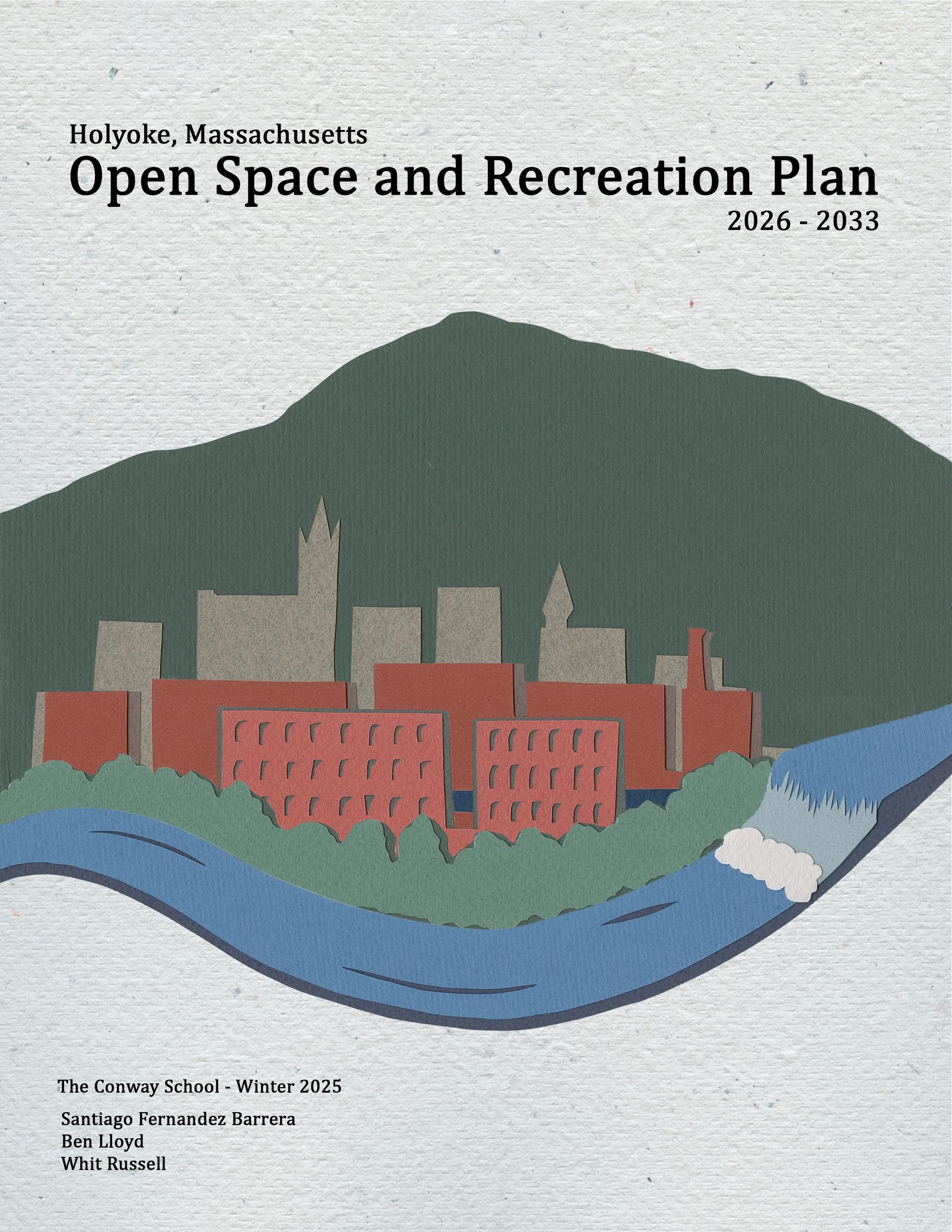
Strategically positioned between the sheer slopes of Mt. Tom and the Connecticut River in western Massachusetts, the city of Holyoke is a microcosm of American history. It's a city built upon the powerful forces of nature to pursue ideals of innovation and industry. It's also a city built by immigrants and those seeking a better life. Like other industrial cities in western Massachusetts, it has undergone economic downturns and today is a remarkable example of community revitalization and resilience.
Holyoke still faces numerous long-term challenges, such as a significant portion of the population living below the poverty line, the environmental risks posed by decaying mill buildings and former industrial sites, and issues related to combined sewer overflow infrastructure. Low-income populations also have disproportionately low access to green space, conservation land, and tree coverage. Additionally, municipal staffing shortages and funding constraints continue to challenge city management. However, Holyoke's narrative is changing from one of decline to one of growth. Dedicated residents, community leaders, and government officials are collectively participating in reimagining the possibilities for their city.
Among its successes, the city has made a concerted effort to protect its natural resources and readapt its historic infrastructure in a way that honors its history but also responds to the needs of its residents. This includes protecting and preserving over 35 percent of land in the city, providing a green corridor for natural communities and a beautiful space for recreation. Holyoke has also charged ahead with adaptive reuse projects, including generating hydroelectric power from the existing dam as well as converting the land of a former coal power plant into a solar array. Other projects also seek to improve the quality of life in urban areas, such as urban forestry plans to combat rising temperatures due to climate change.
This is Holyoke's fourth iteration of the Open Space and Recreation Plan (OSRP), a tool that has been instrumental in guiding the city towards its goals regarding open space. Like previous updates, this document aims to reflect the community's existing needs and aspirations, outlining goals and actions to
enhance the overall quality of life for residents. Feedback from residents, community organization leaders, City officials, and commissions is a vital part of this document, as it cannot accurately represent their needs without their participation and input.
Like previous OSRPs, this one continues to find that support for protecting and preserving the Mount Tom-East Mountain range and the safety of Holyoke’s drinking water resources is ongoing. Holyoke residents treasure the ecological value of these areas, their scenic quality and recreational use. They also value their urban parks but expressed a strong desire to improve the quality and accessibility of city parks, especially in the downtown core. Although the perception that many parks are unsafe, unwelcoming, or not well-cared for seems to be shifting, many still believe that more needs to be done. There is also an ongoing desire for safe and easy access to scenic areas and larger parks and an increased desire for river access.
In accordance with the recommendations from the 2018 OSRP, special consideration has been taken to reach out to the large Spanish-speaking population in the city of Holyoke so as to integrate their voices into the conversation.
This plan supplements other recent City initiatives that promote and suggest strategies for economic growth, implementing green infrastructure, enhancing urban tree canopy coverage, improving bike and pedestrian pathways and conserving and expanding the use of the historic industrial downtown area. Related documents include the Holyoke Comprehensive Plan (2025) and the Holyoke Urban Forestry Plan (2021).
The analyses and recommendations in this document provide a framework to guide actions by the City and community members over the next seven years regarding land protection and management, environmental hazards, park and recreation programs, maintenance, and community engagement.
This Open Space and Recreation Plan envisions a future Holyoke where:
• Parks and recreation facilities are safe, clean, maintained, and enjoyed by people of all ages, abilities, and socioeconomic backgrounds.
• Residents have increased access to open spaces and improved wayfinding to open spaces for people of all ages, abilities, and socioeconomic backgrounds.
• Protected natural resources for people of all ages, abilities, and socioeconomic backgrounds.
• Open spaces serve as community hubs and offer diverse amenities for people of all ages, abilities, and socioeconomic backgrounds.
• The City works in collaboration with community partners to support this community vision.
Image by Whit Russell
Courtesy of Yoni Glogower
2A. S TATEMENT OF P URPOSE
Over the past 25 years, Open Space and Recreation Plans have been crucial in the redevelopment and revitalization of Holyoke. This fourth iteration of this document aims to build upon that positive momentum. Each version enables city officials to assess how plans and projects have progressed, reassess goals and objectives, re-engage the public to ensure community needs are met, and present those findings to the Commonwealth of Massachusetts. While most goals and objectives from prior versions still apply, the authors of this document recognize that much has transpired since 2018, including but not limited to a global pandemic, economic recessions, and ongoing, unprecedented changes to our climate. This document aims to present the city of Holyoke as it stands today and lay out and open space and recreation vision that addresses its shifting demographics, builds on economic revitalization efforts, and increases protection of its natural resources and scenic beauty for future generations.
Despite its relatively small size, the city of Holyoke has abundant natural resources and a variety of ecosystems of statewide importance. From its prime location next to the Connecticut River to the sweeping views of the Pioneer Valley from the Mount Tom-East Mountain Range, Holyoke offers enviable open spaces with opportunities to explore the great outdoors. As a planned city, it also features numerous historic parks and recreational facilities where community members can come together. The city’s past planning and stewardship efforts have protected over 35 percent of its total land area and continue to add parcels that preserve connectivity and existing natural areas. Holyoke also owns 62 parks and recreation facilities, offering playgrounds, splash pads, sports fields, picnic areas, and trails.
This document aims to serve as a tool for both city officials and residents to collaboratively enhance Holyoke's open spaces. It is meant to assist elected officials and resident groups in the decision-making and planning processes, helping them prioritize the residents' needs. The document offers an inventory of land that holds ecological, cultural, and recreational value, including parcels that are
permanently protected, temporarily protected, or unprotected. It assesses and catalogs unmet recreational and resource protection needs while providing guidance on how the City can optimize its limited resources to effectively achieve Holyoke’s open space, conservation, and recreation goals.
As with prior versions, adopting this OSRP signals that Holyoke is proactively working to preserve and protect its natural, cultural, and recreational resources elements essential to Holyoke’s quality of life, economic well-being, and long-term sustainability. This community aims to adapt to environmental challenges and changes. Through collaboration, Holyoke’s elected officials, municipal departments, and the wider community can implement the goals and strategies outlined in this plan. While funding may not currently be available for all identified strategies, flexibility, creativity, and strong community support can assist in successfully prioritizing and implementing the most important initiatives.
What is Open Space?
Open space is a flexible term that refers to land that is undeveloped or only lightly developed into parks, venues, sports facilities, gardens, or other similar spaces. This land can be either publicly or privately owned, accessible to the public or not, and used for active or passive recreation. The category includes protected watershed areas, golf courses, and urban green spaces such as public parks and traffic medians.
Courtesy of Santiago Fernandez
2B. P LANNING P ROCESS AND P UBLIC P ARTICIPATION
This plan updates and builds off of earlier OSRPs (1999, 2005, 2012, and 2018) and on other community assessments and planning documents, including but not limited to: City of Holyoke Natural Hazards Mitigation Plan Update (Holyoke Hazard Mitigation Planning Committee. 2025), Connect. Construct. Create. A Plan for the Revitalization of Center City Holyoke (Devoe et al. 2012), Community Based Assessment of Urban Forestry Conditions (Davey Resource Group 2014), Holyoke Bike Network Plan (PVPC 2016), and the Holyoke Community Report 2017 (Montenegro-Menezes and Stromsten 2017), Community Resilience Building Workshop Summary of Findings, Municipal Vulnerability Preparedness (MVP) Program, Holyoke Urban Forestry Plan (2021). This OSRP was written and revised by students from the Conway School under the direction of Conservation and Sustainability Director Yoni Glogower and Director of Parks and Recreation Tom Reynolds and with support from Maggie Herlihy, Conservation and Sustainability Administrative Assistant. Language from previous OSRPs has been incorporated and supplemented as needed.
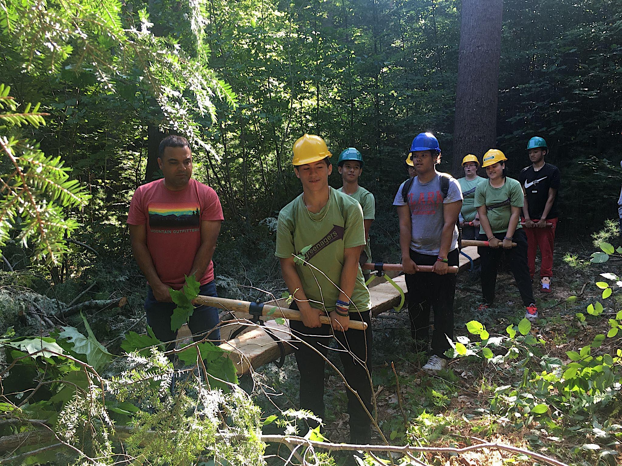
Public outreach for this project began in January 2025 by Conway School graduate students Benjamin Lloyd, Whit Russel, and Santiago Fernández. Students published an online survey in English and Spanish and conducted several tabling sessions at the Holyoke Health Center to engage the public and hear about their use of open spaces and suggestions for improvements. Benjamin Lloyd also participated in a Holyoke Conservation Commission meeting, where he presented ideas and summarized the OSRP public participation process to its members. As of March 2025, there were 67 responses to the survey.
Survey results on the use of outdoor spaces from Holyoke’s 2025 Comprehensive Plan also informed the document's revision of goals and objectives.
2C. E NHANCED O UTREACH AND P UBLIC
P ARTICIPATION
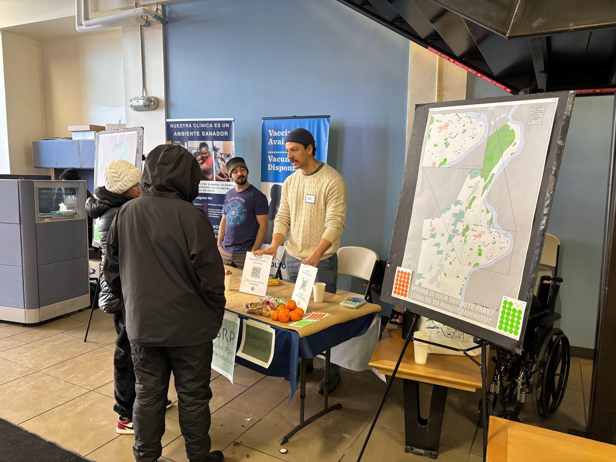
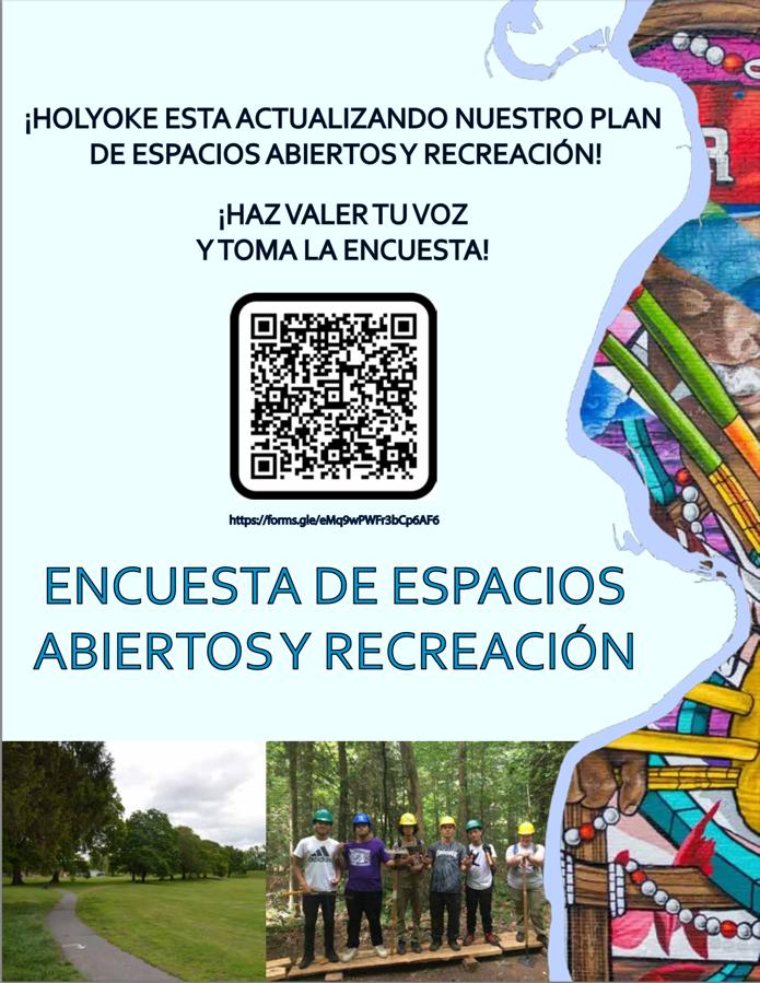
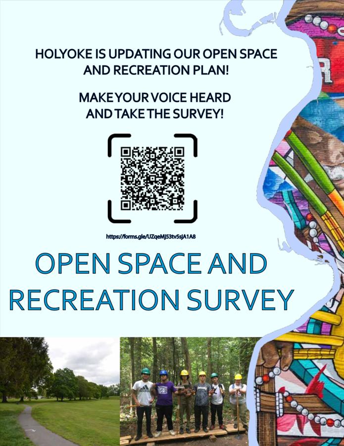
The Conway OSRP update team selected the Holyoke Health Center as a prime location for outreach events, hoping that the position in the center of downtown would enhance participation, particularly from the Latino community, which has historically been underrepresented in public participation. Spanish translation and participation incentives were provided during the event. All survey/questionnaire materials were written in English and Spanish. Surveys were provided physically for those wishing to fill them out as well as online accessible through a QR code. Additionally, the City of Holyoke published the survey on its website using fliers from the tabling event.
To supplement these events, the Conway students connected with specific community organizations, such as Holyoke Rows, Nuestras Raíces, and Holyoke Health Center, to discuss with community leaders their insights on the needs of Holyoke residents. These leaders provided information about how the community utilizes open space and recreational opportunities and identified potential gaps or needs.
CONWAY STUDENTS TABLING AT THE HOLYOKE HEALTH CENTER
Courtesy of Whit Russell
SECTION 3. COMMUNITY SETTING
SECTION 3
Courtesy of Aaron Vega
3 A. R EGIONAL C ONTEXT
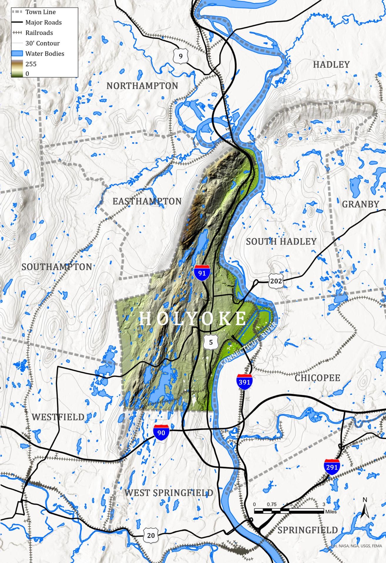
Holyoke, Massachusetts, is a post-industrial mill city spanning 22.8 square miles in the western part of the state. It is situated along the Connecticut River in the Pioneer Valley. It is the third most populous city in Hampden County, following Springfield and Chicopee. Holyoke is deeply connected to the region through planning efforts, transportation networks, and shared natural and scenic resources. The city lies west of South Hadley, Chicopee, and Springfield; east of Westfield, Southampton, and Easthampton; south of Northampton and north of West Springfield (see Map 1).
The Mount Tom-East Mountain range is a volcanic basalt formation that runs through Holyoke from southwest to northeast. A similar formation continues across the Connecticut River valley to the east as the Holyoke Range. These ranges are part of the larger Metacomet Ridge, which stretches from Long Island Sound to northern Massachusetts and marks the western boundary of the Berkshire Plateau. While some rural suburbs have developed on the plateau’s flatter terrain, west of the Mount Tom-East Mountain ridge, most of Holyoke’s growth has occurred east of the range, where the land slopes toward the Connecticut River.
Interstate 91 runs north-south just east of the Mount Tom-East Mountain range, intersecting with Routes 141 and 202, which run east-west. To the south, Interstate 90 (the Massachusetts Turnpike) lies just beyond the Holyoke line. The junction of Interstates 91 and 90 is near the Holyoke Mall, a major regional shopping destination.
Holyoke is well-connected by road and rail. It is about a 90 minute drive from Boston, three hours from New York City, and just 30 minutes north of Hartford and Bradley International Airport. Amtrak’s Vermonter line links the city to Washington, D.C., Philadelphia, New York City, and northern Vermont, while the Pioneer Valley Transit Authority provides bus service within Holyoke and to 23 neighboring towns.
The New England National Scenic Trail traverses the peaks of Mount Tom and East Mountain, connecting Holyoke to 41 communities from Connecticut to the New Hampshire border. The city is home to significant ecological and recreational assets, including the Connecticut River, the Mount Tom-East Mountain range, and the Barnes Aquifer.
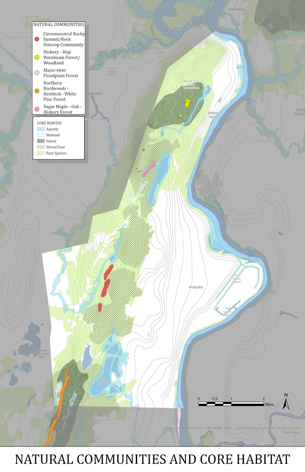
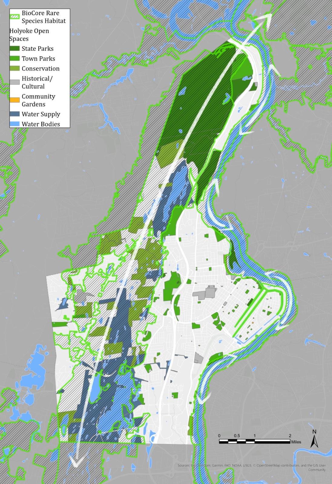
Mount Tom State Reservation is a beloved regional resource, offering 22 miles of hiking trails and panoramic views from its summits. The mountain range is designated as priority habitat by the National Heritage Endangered Species Program (NHESP), supporting one of the highest concentrations of rare and endangered species in Massachusetts. This forested corridor not only serves as a sanctuary and corridor for wildlife but also provides residents with opportunities for passive recreation and access to unique ecological settings uncommon in urban areas.
The Barnes Aquifer, which underlies most of west Holyoke as well as parts of several other towns, is an important public drinking water source for Easthampton, Southampton, and Westfield. In response to contamination discovered in 1988, Holyoke joined these municipalities to form the Barnes Aquifer Protection Advisory Committee (BAPAC), which coordinates efforts to safeguard the aquifer and ensure a sustainable water supply.
Holyoke straddles two watersheds: its southwestern section drains into the Westfield River, while the rest of the city flows into the Connecticut River Basin. Several brooks originating in the Mount Tom-East Mountain range pass through neighboring towns before reaching these major waterways. Paucatuck Brook feeds both Ashley Reservoir and West Springfield’s Bear Hole Reservoir, which serve as critical water sources. Ashley Reservoir, along with McLean and Whiting Street Reservoir, sit in the Holyoke uplands and provide auxiliary drinking water supply to the primary Tighe-Carmody Reservoir in Southampton.
Protecting these water sources and managing development pressures requires collaboration across municipal boundaries. The Pioneer Valley
Planning Commission (PVPC), a public-sector agency representing local governments, leads regional initiatives addressing transportation, open space conservation, and green infrastructure. The broader goals for the area include preserving scenic and natural resources, improving water quality in the Connecticut River and other critical bodies, enhancing connectivity between towns, strengthening local economies, and ensuring that development enhances residents’ quality of life.
PVPC serves 43 towns in Hampshire and Hampden counties, with Holyoke being an important piece in regional coordinated efforts. One such PVPC project was the creation of the ValleyBike Share a bike share network that connects community and commercial centers in Amherst, Northampton, Easthampton, South Hadley, Springfield, and Holyoke. Initiatives like this have the potential to uplift local communities and create an economically vibrant, climate resilient, and culturally rich region.
3B . H ISTORY OF THE C OMMUNITY
Holyoke's location along the Connecticut River made it a prime site for water-powered industrial development in the mid-19th century. The city’s population surged in the late 1800s and early 1900s, with rapid industrial expansion drawing, immigrant communities to the area. This rich history is still reflected in Holyoke’s industrial core, urban layout, land use patterns, and the character of its open spaces and parks.
Before European settlement, the area that would become Holyoke was inhabited by the Pocumtuck, the Nonotuck, the Woronoco, and the Agawam nations, among others, who relied on its rivers and forests for hunting and fishing. English settlers from Connecticut established a community in what is now West Springfield, and purchased the land that would become its third parish, "Ireland Parish," from the Agawam and Nonotuck in 1635 (“History of Holyoke”). Ireland Parish was renamed as Holyoke in 1735. Incorporated as a town in 1850 and later as a city in 1873, Holyoke was initially an agricultural settlement, though the 1700s saw the emergence of small mills and tanneries.
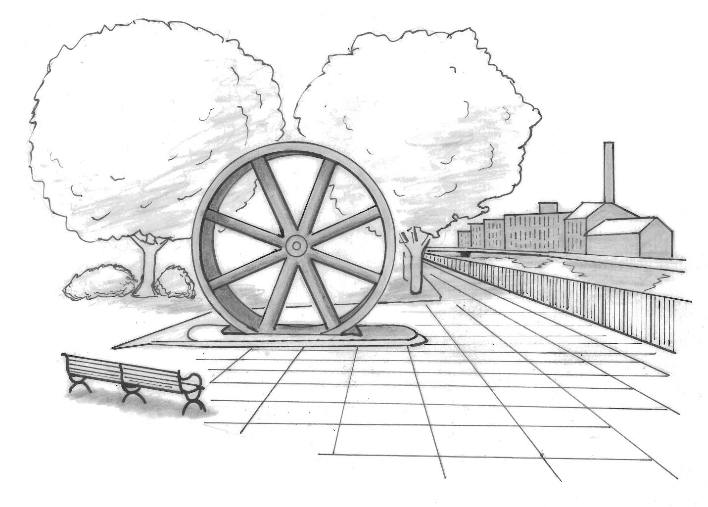
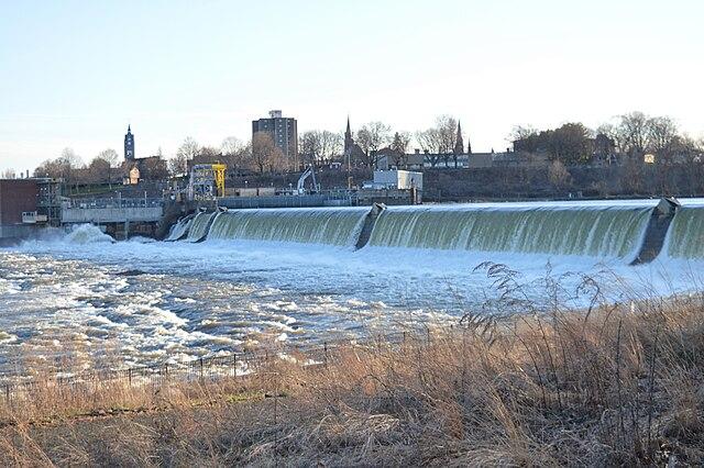
Holyoke's gradual development accelerated with the arrival of the railroad in 1845 and the construction of a dam on the Connecticut River along a 57-foot drop. The dam, built in 1848 by Boston investors, channeled water through a 7.5mile network of hand-dug canals and raceways, which transferred this water-energy through gears and shafts to over 25 mills at the industry's height. The railroad played a crucial role in distributing goods, but the mills’ reliance on the river as a power source and convenient waste disposal kept residents largely disconnected from the waterfront.
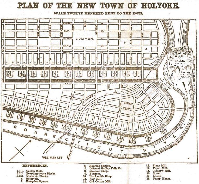
Holyoke was designed as the first planned industrial city in the United States. Its layout included a navigable street grid, factory worker housing in close proximity to city parks, grander lots for mill executives, and a build-out capacity for 80,000 residents. Initially intended for textile production, the city’s mills pivoted to paper manufacturing when the Civil War disrupted the cotton supply from the south. At its peak, Holyoke produced more paper than any other city in the world, earning it the nickname “The Paper City.” Industrial success spurred rapid growth, with the population soaring from 3,245 in 1850 to 35,637 in 1890. While few mills remain active today, the dam, canals, industrial architecture, and grid layout continue to shape Holyoke’s identity.
The population growth in the city was supported largely by immigrants from foreign countries seeking employment and a better life. Spurred by the potato famine in 1847, Irish immigrants came to build the canals and work in the early cotton mills. By 1855 they constituted 35 percent of the city’s residents. French-Canadians and Poles arrived in the late 1800s, followed by German, Russian, Orthodox Jewish, and Greek immigrants after the turn of the 20th century. Since the 1960s, a significant Puerto Rican population has settled in the city, now comprising nearly 45% of its residents (see Section 3C for more on current demographics).
As industry thrived along the canal-ways, commercial activity concentrated around High and Maple Streets. Residential neighborhoods expanded north and west into the Highlands, Oakdale, and Elmwood beyond the original city grid. These areas were developed with a mix of single-, two-,
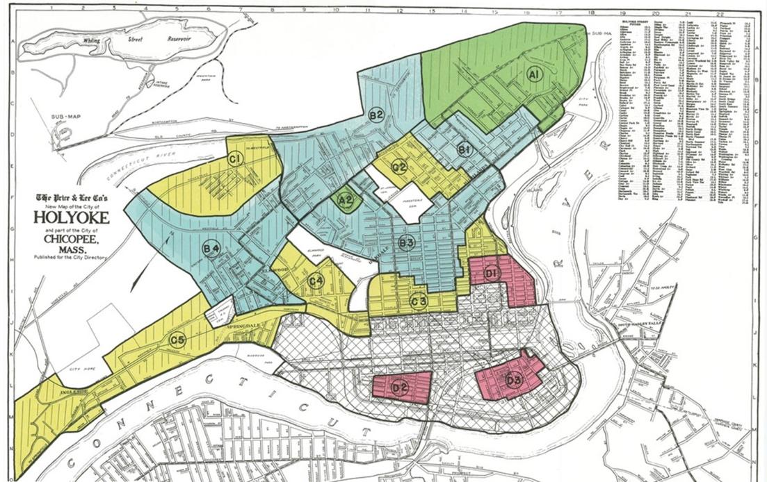
1937 MAP OF REDLINING IN HOLYOKE
and three-family homes, while neighborhoods closer to the mills, including South Holyoke, The Flats, Churchill, and Downtown/Prospect Heights, featured many multi-family apartment buildings.
Open space in the downtown area consisted of small urban parks that provided much-needed recreation for immigrant communities. Pocket parks and community spaces were woven into densely populated areas, while larger parks, such as Pulaski Park and Veteran’s Park, became gathering places for public events. Narrow carriage roads and alleyways, originally designed for pedestrians and horse-drawn carriages, remain in use today for municipal services like trash collection and offer unique open spaces within residential neighborhoods.
Mid-century Home Owners’ Loan Corporation (HOLC) and Federal Housing Administration policies segregated Holyoke’s growing Black and Puerto Rican populations, the latter initially
arriving as agricultural laborers. Redlining, a discriminatory practice where financial services, especially mortgages and insurance, are denied or restricted to residents of certain areas, often based on race or ethnicity, confined them to degrading and poor-quality housing in downtown tenement districts. By 1960, Holyoke’s 526 Black residents were concentrated in three downtown census blocks. A 1966 housing discrimination report identified High Street as the city's "unofficial dividing line" for Black residents. The report starkly contrasted Holyoke’s segregated landscape, describing "the Hill" as a mix of fading grandeur and present hardship. During this period, non-Hispanic white residents of Holyoke increasingly relocated out of town to Springfield’s suburbs (Nelson et. al., 2023).
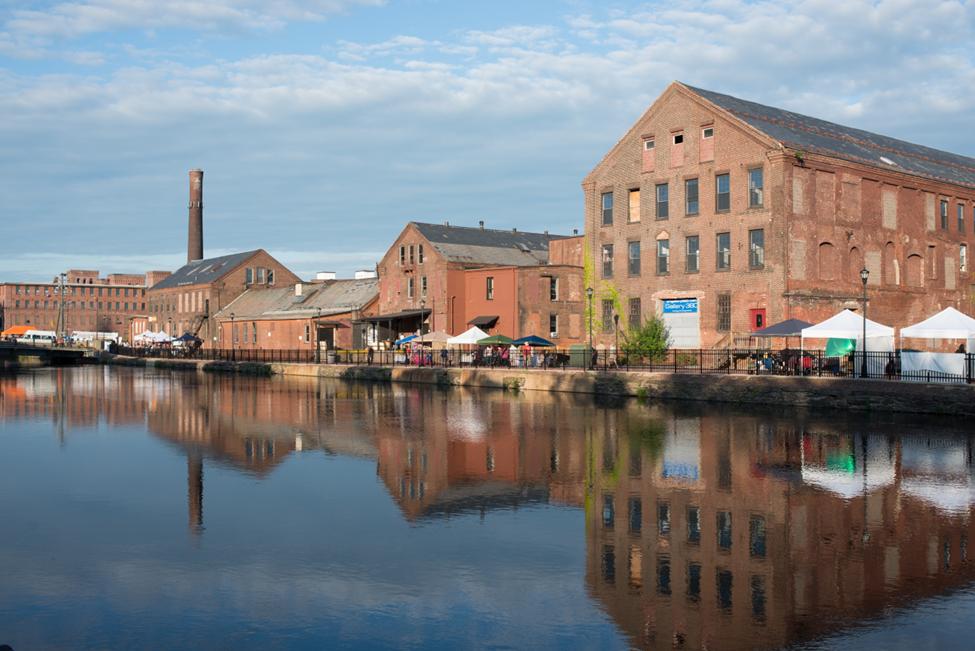
Today, Holyoke’s built environment strongly reflects its industrial and cultural history, with a large amount of the city’s historic mills and housing still standing in and near the downtown. Some of the
structures show the marked stresses of mid-century redlining (see map above) and the mid-to-late-20th century deindustrialization as manufacturing and industry began to shift overseas (Forrant, 2020). Residents now advocate for the revitalization of the urban core, desiring its historical density to accompany new economic opportunities such as cannabis, green industry, and food production, inspired by adaptive reuse of the city’s industrial infrastructure and architecture.
The city’s post-industrial renaissance is beginning to take shape in the energy sector. The city was built on water power and hydroelectricity provided by the dam and canal system. In the last 20 years, Holyoke has expanded its carbon-free energy portfolio. Approximately two-thirds of the city’s energy use comes from the Hadley Station Hydro Project–an addition to the Connecticut Dam. The city also decommissioned Mt. Tom Station–the city’s coal-fired power plant–in 2014 and has since remediated the site and installed a 5.7 MW solar array in its place–the largest community solar project in Massachusetts. Today, Holyoke stands as a leader in Massachusetts in green energy and infrastructure, with over 80 percent of its power in 2023 considered carbon-free (“Clean Energy Dashboard”). This has earned Holyoke the honor of being considered a Green Community by the Commonwealth of Massachusetts Green Communities Division (“Conservation Green Communities”). Further direction to the city will be provided in the upcoming Comprehensive Plan.
3 C. P OPULATION C HARACTERISTICS
Despite a brief upward trend in 2010, Holyoke has experienced decades of population decline. Population and demographic data reveal the downtown core to be denser, younger, and the center of a designated Environmental Justice community residents who are typically most exposed to environmental hazards and who may be in need of safe and accessible open space and recreation opportunities.
Population Demographics
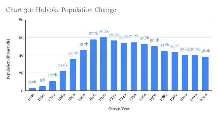
Holyoke’s population has been in decline since its peak in 1920, with a brief upward trend between 2010 and 2018 (see Chart 3.1). Despite efforts to attract business and leverage urban and scenic amenities, this decline has continued into the 2020s (see section 3.D for more information about the City’s Urban Renewal Plan).
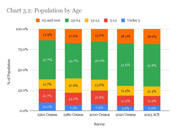
Holyoke’s population has been aging in the past few decades (see Chart 3.2). The median age has risen from 35 at the time of the 2018 OSRP to 39 years as of the 2023 American Community Survey (ACS). The percentage of residents under 25 years has declined from approximately 40% (between 1960–2000) to 30% in 2020, while the working-age group (25–64 years) increased from 42.7% in 1980 to 51.8% in 2023. The population over 65 has also grown.
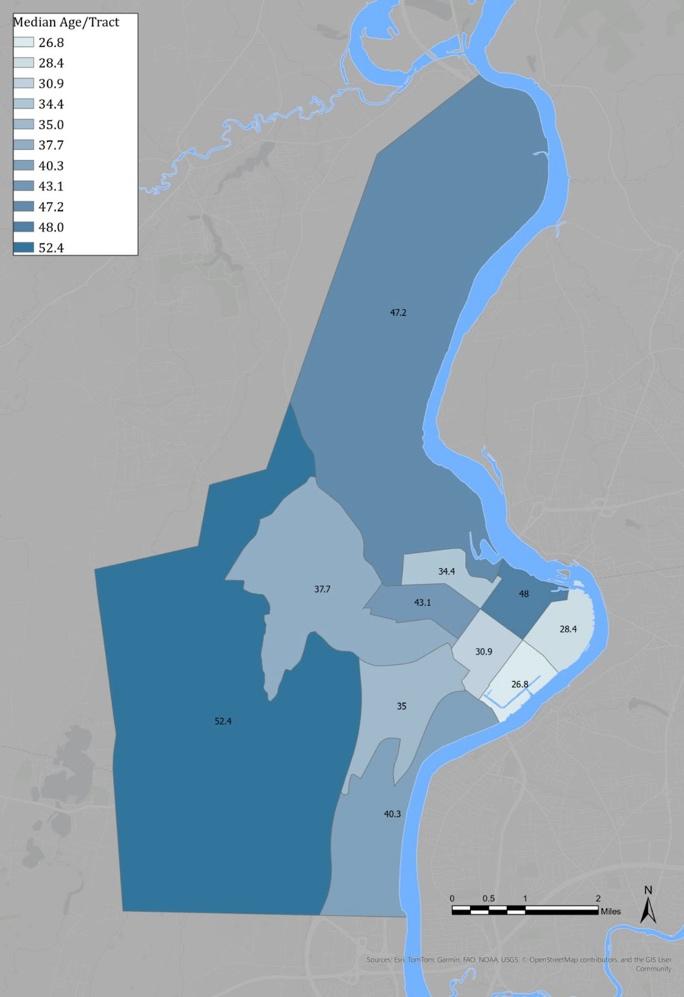
Despite the aging trend, downtown neighborhoods have a notably younger demographic, with a median age of 33.5 years. In contrast, areas north and west of downtown have a median age of 46, indicating an older population in the suburban areas around the city center and west of the Mt. Tom-East Mountain Range (See Map 2, via ACS data).
CHART 3.1: HOLYOKE POPULATION 1850-2020
CHART 3.2 POPULATION BY AGE 1960-2020
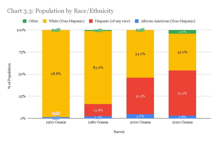
Holyoke has a Hispanic or Latino majority (51.2 percent as of the 2020 Census see Chart 3.3), predominantly of Puerto Rican descent, making it unique compared to Hampden County and Massachusetts, which remain majority white. Cultural and generational differences in Holyoke uniquely influence recreational preferences and make the city a rich environment for multicultural immersion. According to the 2020 census, 42.1% of Holyoke residents are Spanish speakers and 15.5% speak English “less than very well.” With such a robust bilingual population, multilingual outreach, culturally relevant events, and inclusive programming is essential for community equity and accessibility.
CHART 3.3: POPULATION BY RACE/ETHNICITY
Median household income has increased from $31,948 in the 2010 Census to $51,892 in the 2023 ACS, yet it remains significantly below the state average of $101,341. Institutional and infrastructural improvements are necessary to address persistent poverty. The percentage of families living below the poverty line peaked at 28.4% in 2010, declined to 26% in 2020, and further dropped to an estimated 24% in the 2023 ACS,
poverty rate, cost-effective and accessible recreational opportunities are crucial for residents, particularly in downtown areas where economic hardship is concentrated, as well as transportation networks to the various parks in Holyoke’s uplands and opportunities outside of the city limits.
The American Community Survey reported that the unemployment rate in Holyoke has fallen from 8.6 percent in 2013 to 4.4 percent in 2023. This is an encouraging downward trend that is also nearing the state and national average (see Table 3.1).
The city workforce revolves heavily around the Holyoke Health Center, Holyoke Medical Center, and Holyoke Community College. According to Data USA, which synthesizes U.S. Census and American Community Survey data into easy-to-read infographics, the health care and social assistance sector makes up 22.1 percent of Holyoke’s employment base. Educational services make up 13.3 percent of the city workforce, followed by retail services at 11.3 percent (“Holyoke, MA & Massachusetts”). Manufacturing in Holyoke has risen from 7.7 percent at the time of the 2018 report to 9.95 percent as of the 2023 ACA, representing an encouraging rise and suggesting that the city’s investment in green industry and manufacturing is beginning to bear fruits.
TABLE 3.1: UNEMPLOYMENT RATE 2013-2023
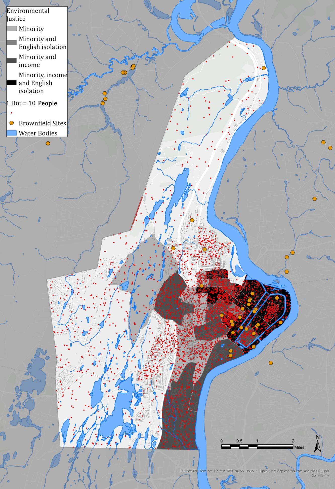
MAP 3: ENVIRONMENTAL JUSTICE POPULATIONS
Environmental Justice Community
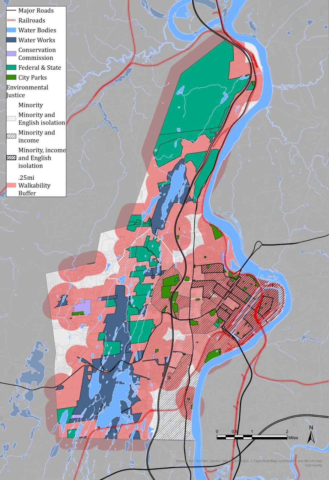
Approximately 24 percent of Holyoke’s land area, particularly in downtown and southeastern neighborhoods, qualifies as an Environmental Justice (EJ) community due to overlapping factors of race, language, and income (see Map 3). All three of the qualifying demographic factors of race, language, and income overlap in Wards 1, 2, and 4. The most dominant factors across this EJ zone are minority status and income limitations. It is worth noting that the bounds of the EJ zone closely resemble the bounds of the 1937 redlining map indicating that while redlining policies have been changed, structural change has yet to uplift these populations from deeply ingrained injustice, and more work is needed on this front.
77 percent of Holyoke residents live in EJ neighborhoods (ACA 2023). Identifying Environmental Justice groups is essential for strengthening municipal efforts to protect these communities from environmental pollution. The designation also highlights often marginalized voices in the community. The 2025 OSRP update process makes deliberate efforts to reach out to these neighborhoods to pursue a representative cross-section of Holyoke residents for more equitable participation.
24 percent of people living in EJ Communities in Holyoke are 18 or younger (ACS, 2023). Further investment in youth programs, playgrounds, and community centers is needed. Recreational activities should reflect the city’s diverse cultural background, including bilingual outreach, culturally relevant events, and spaces catering to different community preferences. High poverty rates necessitate low-cost or free programming and improved transportation access to parks and recreational facilities. The city's designation as an Environmental Justice area reinforces the need for equitable access to clean, safe, and engaging open spaces.
These trends indicate a need for a holistic approach to urban planning, recreation, and social services to meet the evolving needs of Holyoke’s diverse population. Holyoke has put this into practice with projects such as the 2021 Urban Forest Equity Plan,
which focused tree planting in the four neighborhoods with overlapping minority, income, and English isolation EJ designations Churchill, Downtown, South Holyoke, and The Flats. These neighborhoods were also identified to have the least amount of permeable surfaces and tree canopy coverage, while exhibiting the most brownfield sites in the city (City of Holyoke, 2021). Since the plan was penned, Holyoke has partnered with the Commonwealth of Massachusetts and their Greening the Gateway Cities Program (GGCP) to plant trees throughout these neighborhoods. The program has achieved its initial tree planting quota, but more work is needed and underway.
Holyoke Health Characteristics
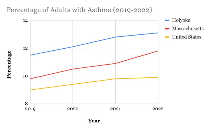
The Pioneer Valley region, especially Springfield, Chicopee, and Holyoke, has historically faced high asthma rates. At one point, the Asthma and Allergy Foundation of America ranked the area as the most challenging place in the U.S. for individuals with asthma. Over the years, the Attorney General’s Office has successfully advocated for reducing pollutants like ozone and particulate matter that enter Massachusetts from sources such as power plants, factories, and vehicles in upwind areas. While significant progress has been made in enhancing air quality, Holyoke has experienced a rise in asthma rates since 2019 (see Chart 3.4) and continues to outpace state and national levels (U.S. Census and ACS).
CHART 3. 4: PERCENTAGE OF ADULTS WITH ASTHMA
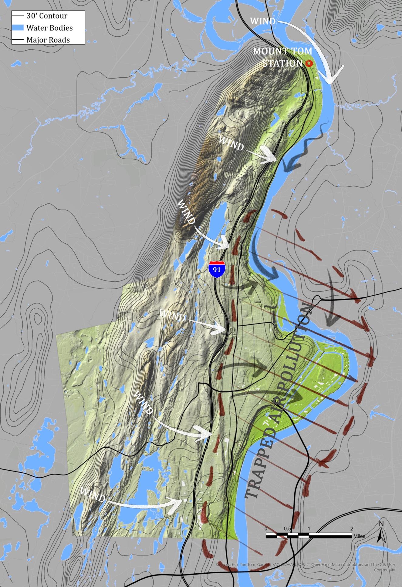
MAP 4: REGIONAL WIND PATTERNS AND AIR POLLUTION
The Pioneer Valley Healthy Air Network was created in 2021 through a collaboration between the cities of Springfield and Holyoke, along with the Public Health Institute of Western Massachusetts, LiveWell Springfield, ReGreen Springfield, the Earthwatch Institute, and the Yale School of Public Health. The initiative received financial support from the Massachusetts Attorney General’s Office’s Environmental Protection Division and the Massachusetts Municipal Vulnerability Program (“Pioneer Valley Healthy Air Program”).
Holyoke’s location in the Connecticut River Valley makes it susceptible to trapped air pollution. As shown in Map 4, prevailing winds sweep air pollution down the valley slopes, over the I-91 corridor, homes, and industry to settle in the valley bottom. In efforts to reduce pollution, Mount Tom Station Holyoke’s coal-fired power plant was decommissioned in 2014 and deconstructed in 2019 and has since been converted into Massachusetts’s largest community solar project. While effective, this is just a part of the community health solution in Holyoke.
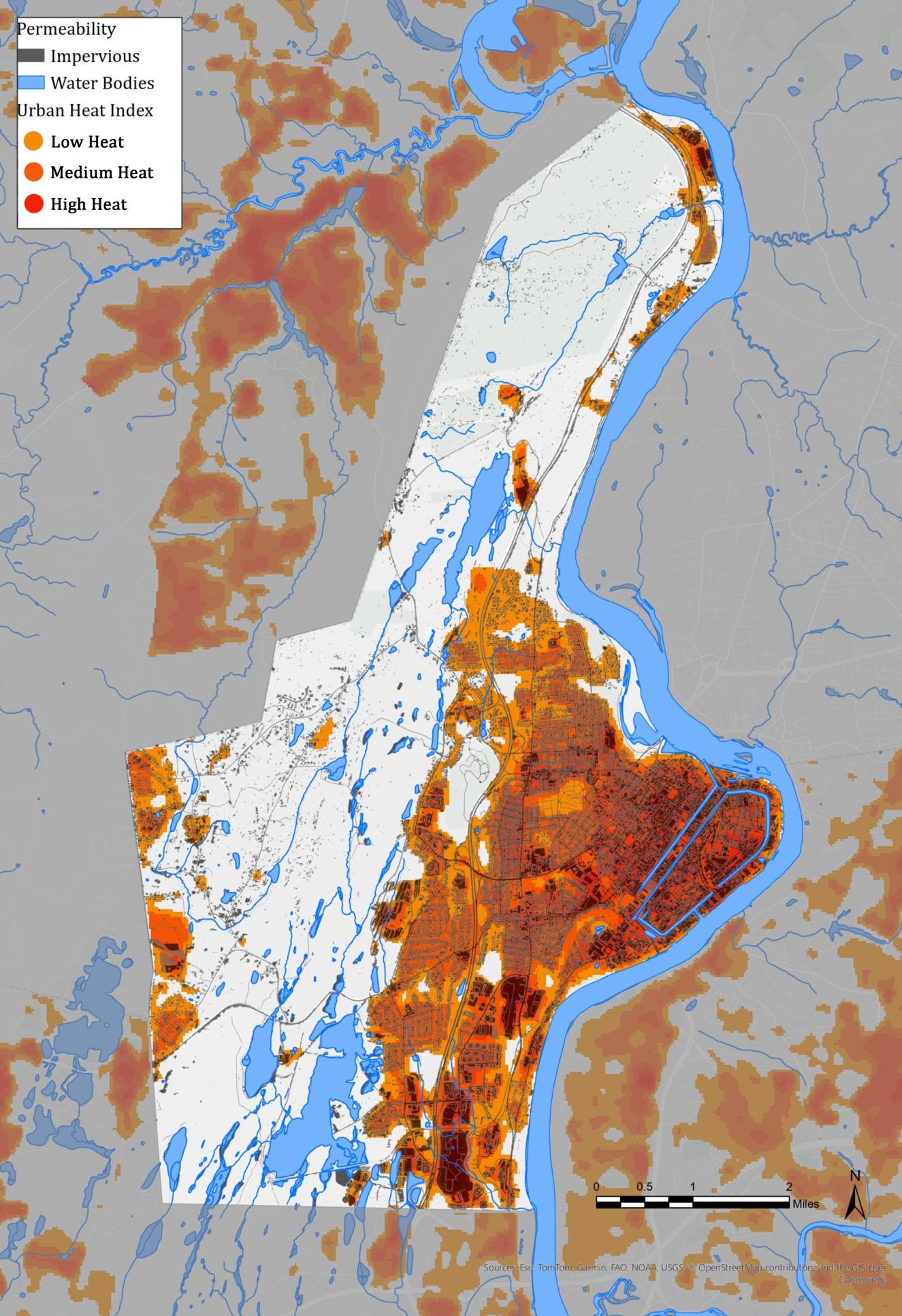
Legacies of redlining have resulted in the inequitable distribution of pollution toward populations of color and Environmental Justice communities. Returning to the Urban Forest Equity Plan, trees and green spaces have an incredibly positive impact on health outcomes. They make cities more livable and enjoyable, they filter air pollution, absorb stormwater runoff, and reduce temperatures (City of Holyoke, 2021). The neighborhoods with the least amount of tree canopy coverage and permeable surfaces were Churchill, Downtown, South Holyoke, and The Flats. This means these areas are the most vulnerable to air and stormwater pollution, as well as the urban heat island (UHI) effect (see Map 5).
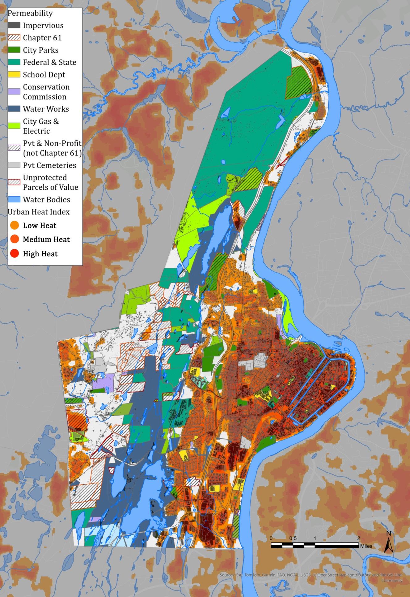
The UHI and valley topography increase the likelihood of low-level temperature inversions, further trapping air pollution (Rendon, et. al., 2014) Map 5 shows impervious surfaces laid over Holyoke’s heat island effect and the direct correlation between the two. Map 6 shows how effective pervious surfaces and parks are at cooling the city down and providing areas of refuge within a large urban heat island. Notably, while progress
has been made to plant trees throughout the center city neighborhoods, more work is necessary. As of the 2024 NOAA LIDAR, only 14.1 percent of The Flats has tree canopy coverage. This is far below any effective tree canopy coverage for a neighborhood in an urban valley susceptible to the UHI effect.
According to many studies, children who grow up near natural areas, or in urban areas with a high prevalence of street trees, are less likely to develop asthma (Lovasi et. al, 2008). Trees filter pollution out of air and cool surface temperatures. Moreover, “according to the best available evidence, nature contact offers considerable promise in addressing a range of health challenges… such as obesity, cardiovascular disease, depression, and anxiety” (Frumkin et al., 2017). Holyoke suffers from higher rates of obesity, diabetes, cardiovascular disease, and depression than the state and national average (see chart 3.5).
These studies suggest that there is significant reason beyond simple aesthetics to maintain, expand, and connect open spaces naturalizing where possible and “regreen” urban areas. Trees, green infrastructure, parks, and nodes of urban ecology are priceless to urban centers like Holyoke, cleaning air and water, reducing temperatures, interrupting damaging stormwater runoff, and improving overall quality of life. As Holyoke continues to develop its downtown Environmental Justice neighborhoods, it is pertinent that it continues to recognize that tree planting and nature immersion have immense effects on public health outcomes.
CHART 3.5: PERCENTAGE OF ADULTS WITH DEPRESSION
6: REGIONAL WIND PATTERNS AND AIR POLLUTION
MAP 5: URBAN HEAT ISLAND AND IMPERVIOUS SURFACES
7: REGIONAL WIND PATTERNS AND AIR POLLUTION
MAP 6: URBAN HEAT ISLAND EFFECT AND ITS RELATION TO OPEN SPACE
3.D
G
ROWTH AND D EVELOPMENT C HARACTERISTICS
Land use in the city of Holyoke varies widely from the rural west to the historic and highly developed downtown in the east. The development patterns shaping the land early in the City’s history persist today and further development will be shaped and limited by the undulating landscape and zoning ordinances. Redevelopment and infill, especially within the urban core, are the City’s current focus for the growth of the built environment. Meanwhile, current infrastructure provides Holyoke with energy, water, and transportation connections to the region.
Historical Development Patterns
The earliest known inhabitants of the Connecticut River Valley in the areas around modern-day Holyoke were those of the Pocumtuck, the Nonotuck, the Woronoco, and the Agawam nations, among others. They used the Connecticut River as a transportation corridor that connected regions. They fished and foraged along its edge and found abundance along its alluvial floodplains.
European settlers, too, found the prominent floodplain that became Holyoke by navigating up the Connecticut River. Settlers purchased the land in unscrupulous deals from the Agawam and Nonotuck, and the floodplains were first tilled for farming in 1635 (“History of Holyoke”). The area remained in agricultural use until 1847, when industrial speculators sought to take advantage of the 57-foot drop in the river for water power.
Soon after, the town of Holyoke was established, with a modern gridded plan that organized mills, businesses, and dense worker housing around a dam, upper and lower canal system, an enterprising railroad, and a matrix of roads that stretched across the flatter, easily developed alluvial surficial geology, north to Northampton, and south to West Springfield. In a few short decades, Holyoke transformed from a sparsely populated farming community to a thriving industrial hub. Factory owners built their homes to the west of downtown,
further up the Mount Tom-East Mountain slope, where they were out of the way of prevailing winds and the city’s smog.
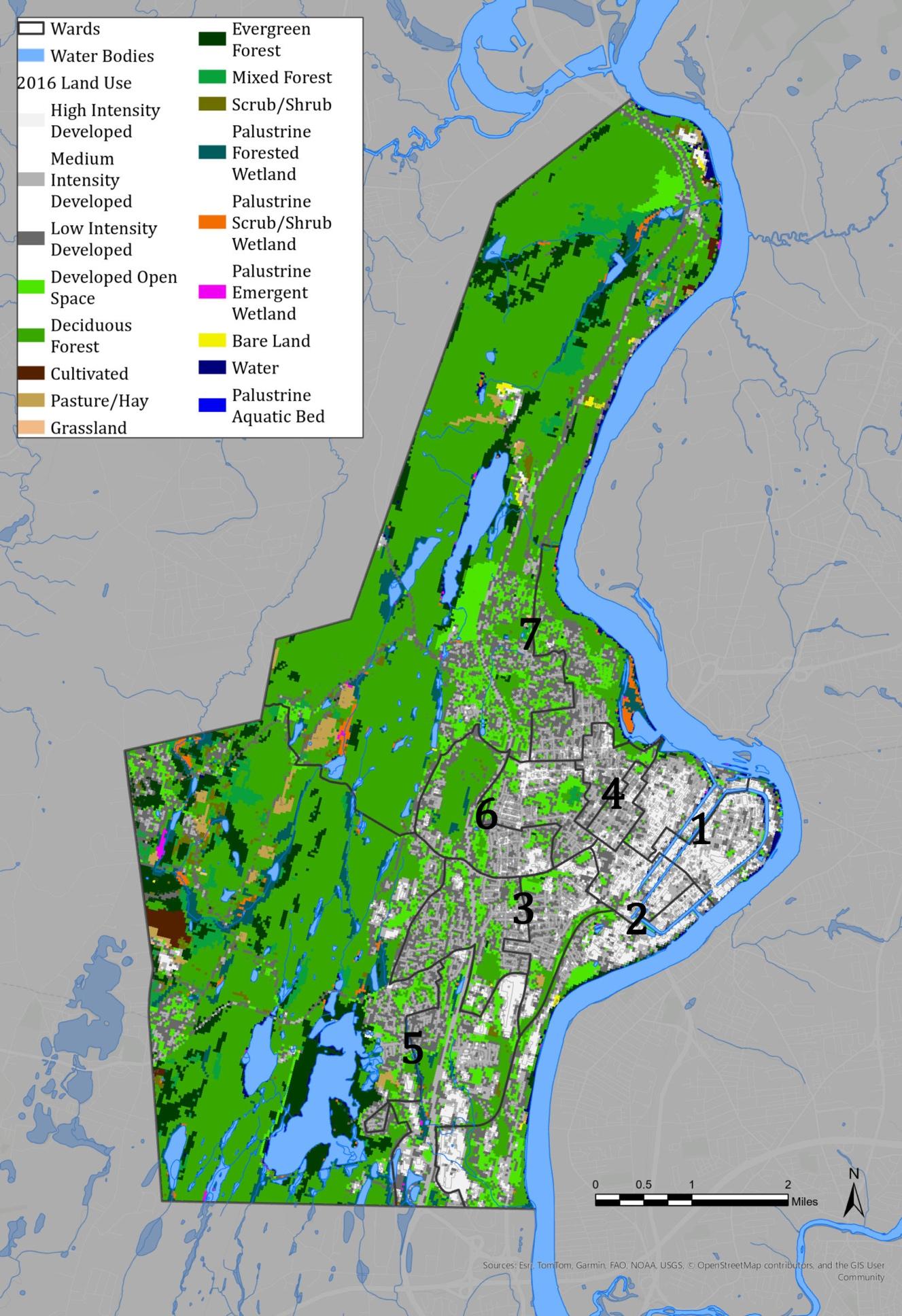
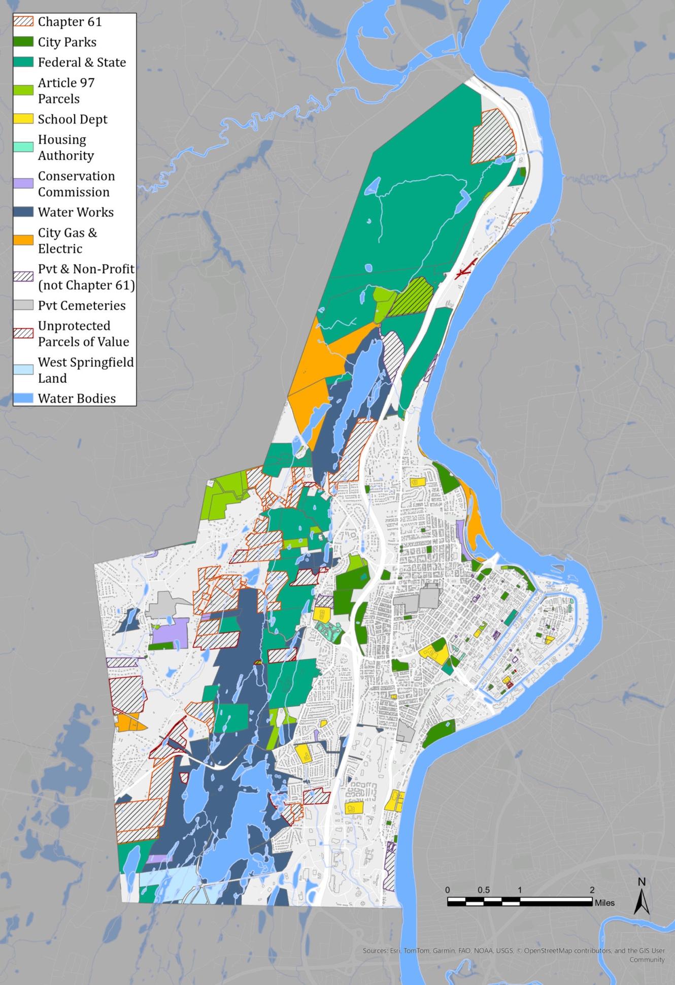
The mountain range acted as a natural barrier, limiting development through the city’s center and dividing west from east Holyoke. These geographic patterns continue to shape the city today. The mountain range and the forested lands surrounding the reservoirs have remained largely undeveloped, forming a wide north–south corridor of protected uplands (see Map 7). To the west, this natural area transitions into rural pasture, farmland, and suburban residential neighborhoods, farthest from the city’s historical industrial core. To the east, denser residential neighborhoods house the majority of Holyoke’s population. Commercial activity is concentrated along High, Maple, Main, and Northampton Streets, with a major hub around the Holyoke Mall and nearby properties in the southeast. Industrial land use remains prevalent along the canal system and the Connecticut River, interwoven with residential areas.
Many former mills, once the backbone of Holyoke’s industry, are now focal points for redevelopment, preserving the city’s tradition of mixed-use spaces in the downtown area. Multifamily housing is concentrated east of Northampton Street and south of the Highlands neighborhood, while single-family homes dominate much of the city’s other residential areas. Holyoke’s early planned growth led to the development of distinct neighborhoods, shaped by architectural trends and economic stratification, creating a character that remains evident today. However, historical alleyways and carriage roads, tighter than primary traffic corridors, are increasingly vulnerable to encroachment by business owners, reducing their accessibility and historical function.
The Mount Tom–East Mountain range retains much of its wilderness, though its land is owned by a variety of organizations. Holyoke Water Works and the Parks and Recreation Department manage key parcels, particularly around the city’s reservoirs Whiting Street Reservoir in the north and Ashley and McLean in the southwest. Mount Tom is primarily protected by the Department of
1850 HADLEY FALLS COMPANY PLAN FOR HOLYOKE, MA
Conservation & Recreation, while MassWildlife (DFG) oversees parcels around East Mountain. The Trustees of Reservations own sections of Little Tom Mountain and land along the river. This mixed ownership structure necessitates collaboration and coordination among stakeholders.
The Holyoke Mall in Ingleside emerged as the city’s primary economic hub by the late twentieth
century, particularly as growth stagnated in other areas. Holyoke’s rapid industrialization, coupled with the physical constraints imposed by the Mount Tom–East Mountain range, has resulted in a scarcity of easily developable land in the twenty-first century. According to the 2012 OSRP, over 90% of the city’s land is either already developed or protected from development, leaving just 10% available for future growth. Further study is required to determine if all of this land is in fact developable, or if slope or infrastructure
accessibility limit that number even further. What is clear is that if the city were to experience dramatic growth, it would be in proximity to the urban core.
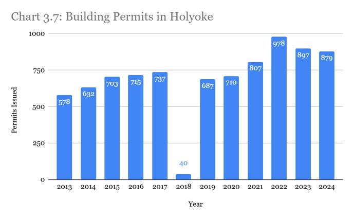
Despite constraints, development continues in Holyoke. Building permit issuances since 2013 are trending up, with a peak in 2022 following COVID stimulus (see Chart 3.6). It is believed that there was a data loss in 2018 where building permit numbers were recorded to show 40 total for the year. The majority of active permits are concentrated in the eastern half of the city, particularly within the downtown industrial and commercial core. Additionally, since 2018, the Conservation Commission has processed 44 Determinations of Applicability and 49 Notices of Intent for construction near wetlands, reflecting a wide range of economic activity, including infill development, brownfield remediation, and largescale commercial projects.
CHART 3.6: BUILDING PERMITS IN HOLYOKE 2013-2024
Although large-scale residential subdivisions are unlikely, Holyoke remains an active development landscape. The city prioritizes reinvestment and redevelopment in the downtown core, aiming to balance economic growth with environmental preservation by minimizing the impact on wildlands and open spaces.
Agriculture in Holyoke
Nuestras Raíces a grassroots organization deeply embedded in Holyoke’s agricultural community leads efforts on food security, food justice, and farmer training. The organization manages eight of the nine community gardens throughout Holyoke; the other being the Dwight Street Community
Garden owned and managed by Neighbor to Neighbor. These community gardens are primarily situated in the urban core and southeast Ingleside neighborhood in areas identified as Environmental Justice communities where residents often face food access challenges due to race, income, and language barriers.
According to the last OSRP update, community gardens in Holyoke have seen a reduction from eleven to eight, but every effort should be made to expand these resources for the community. Nuestras Raíces has expressed interest in buying the community gardens they manage to preserve them in perpetuity. Especially when they are wellmaintained, the gardens serve as community hubs for education, skill sharing, cultural exchange, and nature connection all of which help build community pride. At the farm scale, Nuestras Raices operates a riverfront community farm on a 25-acre parcel called Land of Providence owned by the Trustees with accessible walking trails, incubator resources that serve nine agrarian businesses, and a community center and event space.
There is also an orchard (Seidel Farm) and a berry farm (Little Pond Orchard) that both operate in the uplands, along with some livestock and haying operations west of the range. Further collaboration among Nuestras Raíces, the City, and other local stakeholders especially at the public boat launch where interests overlap is encouraged to improve food security and expand recreation opportunities for Holyoke residents.
Infrastructure
Water Supply
Holyoke is one of only five Massachusetts communities exempt from state filtration requirements due to its exceptional drinking water quality. The Holyoke Water Works (HWW), a municipal entity, manages the city's water supply and distribution system. The Tighe-Carmody Reservoir, located in Southampton, serves as the city’s primary source, providing drinking water to over 99% of Holyoke residents. A small fraction those in the Rock Valley and Smith’s Ferry neighborhoods rely on private wells.
MAP 7: DEVELOPMENT AND OPEN SPACE BY WARD
8: REGIONAL WIND PATTERNS AND AIR POLLUTION
Within city limits, Ashley Reservoir (safe yield: 2.1 mgd) feeds water to McLean Reservoir (0.5 mgd), where it is treated before distribution. Though not currently in use, Whiting Street Reservoir (safe yield: 1.5 mgd) remains a backup water source (21). It is also a popular recreational area, but state law prohibits water-based activities if it remains designated for emergency use, which the Whiting Street Reservoir Committee has recommended as part of its 2022 study (City of Holyoke, 2022).
Holyoke’s daily water consumption is significantly below its available capacity. The decline of large industrial users and population shifts have left the city with ample water supply. This has left the City with the ability to support future growth without straining water resources.
Sewer System
Sewer service covers Holyoke’s densely developed areas, with a treatment plant on Berkshire Street, near the Connecticut River. This facility, designed for 17.5 mgd average daily flow and 37.0 mgd peak flow, has supported industrial expansion in Ingleside and residential growth in Whiting Farms.
West Holyoke and parts of Smith’s Ferry remain unconnected to the system. As there are no current plans to extend sewer service, development in these areas may be constrained where septic systems are not viable.
Combined Sewer Overflows (CSOs)
Holyoke’s 117-mile sewer network is over a century old, with two-thirds operating as a combined sewerstormwater system. As of 2023, 10 CSOs continue to discharge effluent into the Connecticut River. This is a reduction from 14 CSOs in 2018. While designed to prevent system overloads during heavy rainfall, CSOs remain a major pollution source.
Holyoke has been actively addressing combined sewer overflows (CSOs) in collaboration with federal and state environmental agencies. Recent efforts include separating sewers, eliminating overflows in the Jackson Street area, and finalizing a long-term overflow control plan. Under a consent decree, the city must further separate sewers,
reduce stormwater pollution, and remove illicit connections and have committed to developing an Integrated Management Plan to identify infrastructure needs, prioritize projects, engage the public, and secure funding through grants and capital planning (Holyoke, EPA).
Transportation
Holyoke’s transportation network includes major highways, rail connections, and public transit services, facilitating regional access. Interstate highways are as follows:
• Interstate 91 (I-91) runs north-south along the city's western edge, linking Holyoke to Springfield and Connecticut to the south, and Northampton and Vermont to the north
• State Highway 5 parallels I-91 to the east, and served as a primary route before the interstate's construction
• Interstate 391 (I-391) begins in Springfield and terminates in Holyoke’s High Street district
• Interstate 90 (Mass Pike) runs east-west just south of the city, fostering commercial growth in Ingleside, particularly around the Holyoke Mall
The construction of I-91 in the 1950s divided Holyoke, limiting connectivity between the urban core, Anniversary Hill Park, and western neighborhoods. Few underpasses cross the interstate, further restricting movement. While Anniversary Hill Park still suffers from the isolating effects of I-91, great strides have been made since the 2018 OSRP to improve accessibility, bury utility lines, and upgrade the trails leading to Scott Tower. This work, including the purchase of 14.1 acres just north of Scott Tower that could provide another access point to the park, was made possible with Community Preservation Act (CPA) funding and a generous grant from the Kestrel Land Trust.
Holyoke is also intersected by several key state highways:
• Route 141 connects Easthampton, downtown Holyoke, and Chicopee, crossing the Mount Tom-East Mountain range.
• Route 202 runs east-west from Westfield, crossing the Connecticut River via the Mueller Bridge into South Hadley.
• Route 116 links Holyoke to Chicopee and South Hadley, crossing the river via the Vietnam Veterans’ Memorial Bridge and Willimansett Bridge.
These roadways, along with multiple river bridges, provide potential opportunities for walkable and bikeable access between neighboring communities.
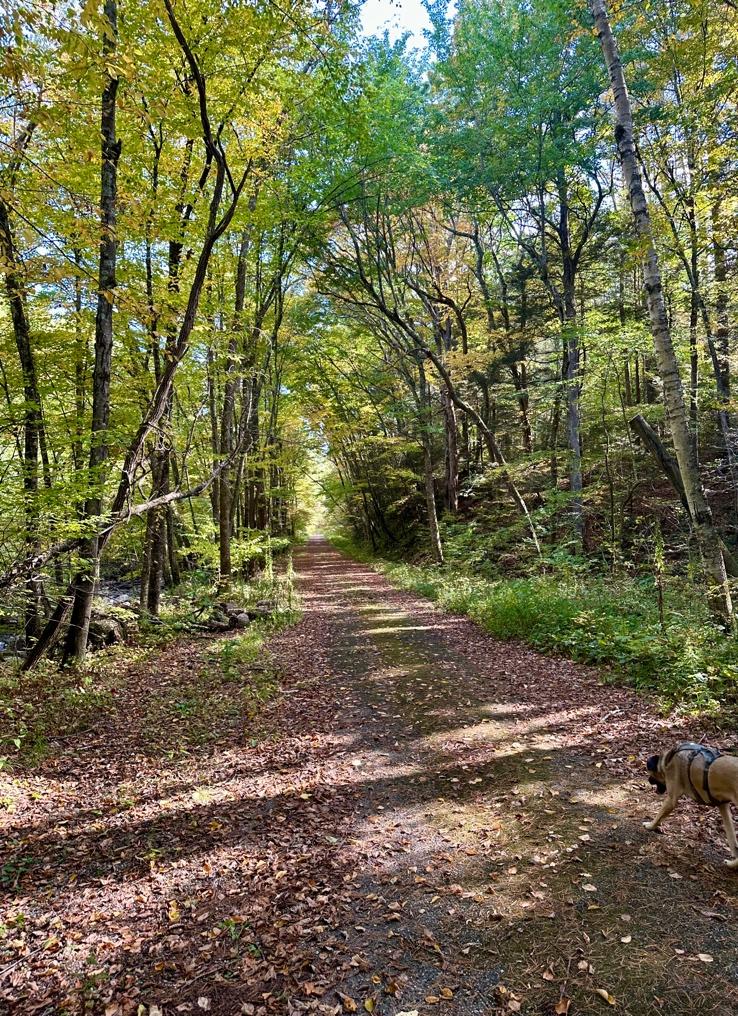
Mass Central Rail Trail Case Study
The Rails to Trails Conservancy transforms disused railroad corridors into public trails. Nationwide the organization has helped develop more than 25,000 miles of trails with the help of grassroots organizations. In Massachusetts, 36 miles of the Massachusetts Central Railroad, which ran from Boston to Northampton until 1938, have been converted into rail trails. In the Pioneer Valley, the Norwottuck Branch and Francis P. Ryan Branch connect Belchertown to Leeds. The trails pass through wildlife areas and business centers that connect to other bike paths.
cities, while Peter Pan Bus Lines offers intercity service.
Amtrak’s Vermonter service, with a station at Dwight & Main Street, provides daily rail service between St. Albans, VT, and Washington, D.C.. Expansion plans propose extending service from St. Albans to Montreal, Quebec, Canada (Vermonter Extension to Montreal). Freight operations are handled by Pioneer Valley Railroad, a short-line carrier serving industrial and warehouse facilities between Holyoke and Westfield.
Although rail lines improve regional connectivity, they create barriers within Holyoke, particularly by restricting access to the Connecticut River and isolating The Flats neighborhood from downtown. Since crossing the tracks is illegal, this remains a significant urban planning challenge.
Airports
Regional airports include:
Public Transit and Rail
The Holyoke Transportation Center, redeveloped in 2010, serves as the city’s primary transit hub. The Pioneer Valley Transit Authority (PVTA) operates 10 bus routes, connecting Holyoke to neighboring
• Bradley International Airport (CT), 20 miles south, which is the nearest major airport.
• Barnes Airport (Westfield) and Westover Air Reserve Base (Chicopee) which accommodate private, corporate, and military aviation.
Multi-Use Trails and Alternative Transportation Holyoke’s Canal Walk is the City’s only existing multi-use trail, though opportunities exist to expand regional connectivity:
• The Manhan Rail Trail, a six-mile route in Easthampton, links to the Norwottuck Rail Trail in Northampton.
• Extending Holyoke’s trail system to Springfield’s Connecticut Riverway & Bikeway and Chicopee’s River Canal Trail could create a seamless network for cyclists and pedestrians.
To support alternative transportation, the PVPC completed the Holyoke Bike Network Plan in 2016, proposing a comprehensive bike network throughout Holyoke (PVPC, 2016). Please see the forthcoming Holyoke Comprehensive Plan for
Courtesy of Santiago Fernandez
updated information regarding bike connectivity. Holyoke also joined the ValleyBike Share program in 2018, with bike stations located in critical areas throughout Holyoke.
The New England National Scenic Trail (NET) and the Manhan Rail Trail intersect just north of Holyoke, offering a 215-mile hiking route through Massachusetts and Connecticut. NET trailheads within Holyoke, located along Routes 202 and 141, provide access to the Mount Tom State Reservation, showcasing classic New England landscapes, forests, and river valleys.
Renewable Energy and Green Technology
Designated as a Green Community by the Commonwealth of Massachusetts’ Green Communities Division, Holyoke is committed to reducing emissions and advancing renewable energy initiatives in alignment with the Green Communities Act. Through strategic investments and partnerships, the City is positioning itself to meet the evolving energy demands of the twentyfirst century while maintaining its leadership in sustainability.
The key driver of Holyoke’s renewable energy success is Holyoke Gas & Electric (HG&E), which has developed 17 solar facilities capable of generating 17.82 MW of clean, carbon-neutral energy (“Solar Energy”). Additionally, the Holyoke Dam supplies nearly two-thirds of the city’s total energy needs (“Hydroelectric Energy”). Cumulatively, 80.16 percent of Holyoke Gas & Electric’s energy production was considered carbon-neutral in 2023 (“Clean Energy Dashboard”).
The city’s abundant and affordable clean energy was a key factor in the decision to locate the Massachusetts Green High Performance Computing Center (MGHPCC) in Holyoke. This state-of-the-art supercomputing facility developed in partnership with universities and research institutions supports advanced work in climate modeling, biotechnology, and data science. The presence of MGHPCC, coupled with Holyoke’s robust renewable energy infrastructure, has the potential to attract additional green technology and information technology firms.
Additionally, ongoing projects like the Holyoke Canal Walk demonstrate the City’s commitment to blending historic preservation, recreation, and economic development. By transforming the city’s historic power-generating canal system into a pedestrian-friendly green space, Holyoke continues to promote sustainable growth while enhancing the quality of life for residents and visitors alike.
Long-Term Development Patterns
Development Potential and Constraints
As previously noted, Holyoke's new development is constrained by the limited availability of buildable land. However, opportunities for growth exist in select areas, particularly in West Holyoke, Ingleside, and Smith’s Ferry. These developable areas are largely flat, equipped with municipal water and sewer, and easily accessible though they are becoming increasingly scarce.
In West Holyoke, there is potential for additional single-family homes if larger lots are subdivided. However, this could come at the cost of scenic landscapes and valuable natural resources, including prime agricultural soils and the water recharge zones for the Barnes Aquifer.
Given the City’s commitment to increasing density in urban areas, future development and redevelopment efforts will primarily focus on the urban core. The City was originally planned to house expansive industry and 80,000 residents. With the current population under half that, abundant clean, inexpensive energy, and empty mill buildings waiting for repurposing, the setting is ripe for revitalization.
Commercial and Industrial Growth
Holyoke is undergoing a commercial and economic renaissance, leveraging its strategic location, clean energy resources, and industrial history to attract new businesses and a clean-energy industry. Holyoke successfully recruited Sublime Systems, a clean-tech startup developing fossil-fuel-free, lowcarbon cement. Sublime will operate from a longdormant site on Water Street, creating over 70 jobs by 2026. The city’s inexpensive, renewable
hydroelectric energy was a major factor in attracting the company. Officials aim to establish Holyoke as a hub for green technology and innovation. Other clean-tech businesses, including Clean Crop Technologies and Revo Zero, a hydrogen-energy supplier, have also chosen Holyoke for expansion, reinforcing the city’s role in Massachusetts' emerging “climate corridor” (Holyoke Wants to Move ‘Way Beyond Potential’, George O’Brien, Business West).
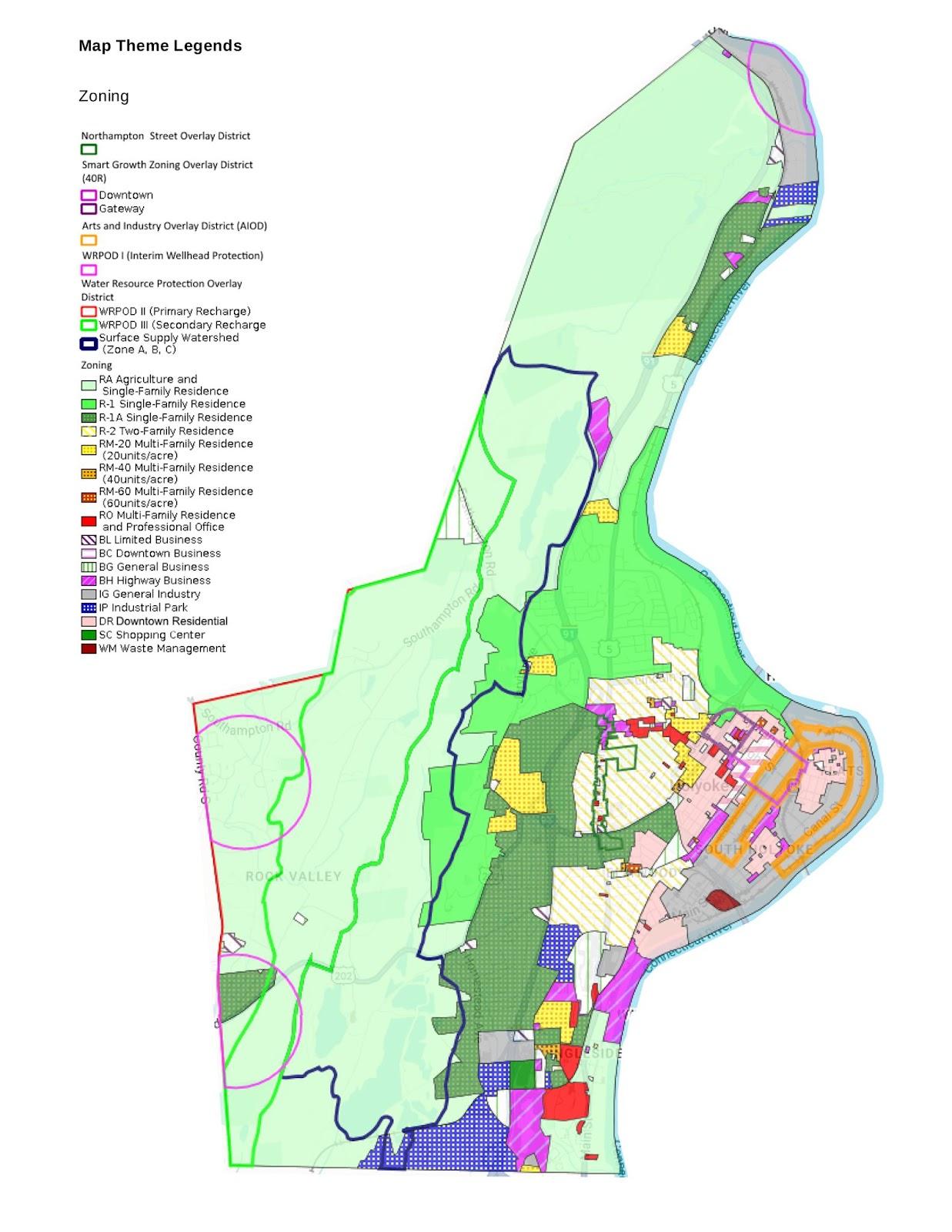
Zoning and Land Use Planning
Holyoke’s zoning framework is designed to balance economic growth with environmental preservation. The City prioritizes economic development within existing commercial, residential, and industrial zones while minimizing impacts to sensitive ecosystems and water resources.
The city’s zoning map reflects a mix of residential, commercial, and industrial districts:
Residential Zones
Predominantly located west of the city center, these areas consist of single-family and multifamily districts, with pockets of commercial zoning along Northampton Street (Route 5) and other key corridors. In the northern and western regions, larger residential lots are subject to water resource overlays, requiring a minimum lot size of two acres and 200 feet of frontage.
Commercial and Business Districts
Concentrated along major highways and in southeastern Holyoke, just north of the intersection of Interstates 90 and 91. Some sections of downtown also feature commercial zoning.
Industrial and Manufacturing Zones
Historically concentrated along the canal system and the Connecticut River, these districts continue to support Holyoke’s industrial legacy.
Several special overlay districts have been established to promote sustainable development:
Water Resource Protection Overlay District Safeguards the Barnes Aquifer and other critical water resources by restricting impervious surface
coverage and limiting potentially polluting activities.
Arts and Industry Overlay District: Encourages mixed-use redevelopment around the historic canal system, supporting adaptive reuse of mills and diversified housing.
Smart Growth Zoning Overlay District: Promotes transit-oriented development near key transportation nodes, including the Holyoke Transportation Center and Amtrak station.
Floodplain Overlay District: Based on the most updated FEMA flood maps, this district restricts development within 100-year flood zones, except by special permit.
Revitalizing Downtown Holyoke
Holyoke’s downtown- comprising The Flats, South Holyoke, Churchill, and Prospect Heights /Downtown was once the city’s economic and cultural hub. However, these neighborhoods now have high vacancy rates. The City would like to see these vacant lots revitalized actively encourages downtown redevelopment through various financial and zoning tools, including the Tax Increment Financing (TIF) program, the Downtown Residential Zone, and the Smart Growth and Arts and Industry Overlay Districts.
Holyoke’s updated 2020 Urban Renewal Plan (URP) Connect. Construct. Create. outlines a comprehensive strategy for combating blight and abandonment using smart-growth principles. The plan emphasizes compact, mixed-use development, adaptive reuse of existing structures, and a broad range of housing opportunities to allow for advancement within industry and housing in the city. The forthcoming Comprehensive Plan (expected to be completed in June 2025) will surely expand on these principles.
MAP 8: ZONING AND LAND USE
One major project, set to open in early 2025, is WinnDevelopment’s $55.3 million transformation of the former Farr Alpaca Mill into the Residences on Appleton, creating 88 affordable apartments for residents 55 and older. Additional housing developments include market-rate condo lofts for young professionals and the restoration of 8- to 20unit apartment buildings with ground-floor retail along High Street. A large former bank building on High Street is also being considered for residential use, while zoning changes allow for live/work spaces in converted mill buildings. MassHousing, a quasi-public agency specializing in financing affordable housing, is actively supporting these projects, having contributed over $29 billion statewide to affordable and mixed-income developments since its inception (“Holyoke, Massachusetts: A Planned City with Plenty of Room to Grow,” 2024).
These proposed housing projects complement recent developments, such as the Holyoke Senior Center and Lyman Terrace housing redevelopment, that offer sustainable, well-constructed low-income housing and amenities to City residents. Importantly, as the city center continues to grow and attract business, infrastructure and parks must also be maintained and upgraded to meet demand. This will almost certainly strain already-tight DPW budgets. Recent improvements around the city center include Kennedy Park, the Canal Walk, and Pina Park.
Balancing Development with Open Space and Environmental Considerations
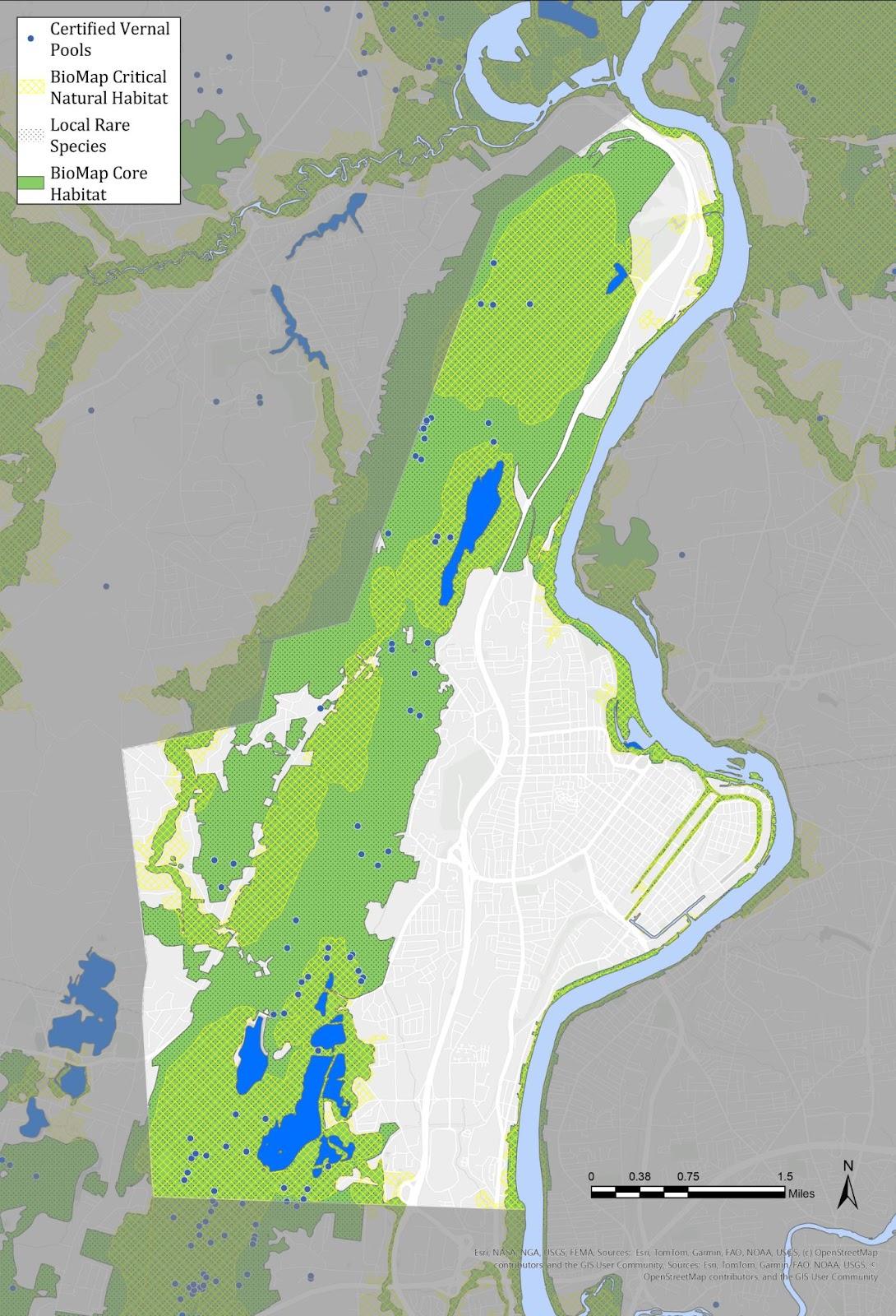
As development continues, Holyoke must navigate challenges related to open space preservation, wildlife habitat, and wetland protection. Much of the remaining undeveloped land contains environmental constraints such as wetlands, Priority Species Habitat, vernal pools, hydric soils, steep slopes, or flood zones. While state law permits development within 100 feet of a wetland with appropriate permitting, the City enforces a stricter 50-foot No-Build Zone under its local wetlands protection ordinance regulations.
Looking ahead the city would like future development to include further urban infill and
mixed-use development in the downtown core, continued brownfield redevelopment in both urban and rural areas, and renewable and clean energy projects and businesses.
Courtesy of Santiago Fernandez
4A. T OPOGRAPHY , G EOLOGY , AND S OILS
Holyoke's landscape was shaped by dynamic geological processes that created a range of features like shallow bedrock and rocky basalt outcroppings, offering habitat and scenic vistas alongside streams and wetlands that filter and direct fresh water to the city’s reservoirs. The city's soil profile includes a variety of types formed by various glacial and riverbasin processes, with some valuable agricultural soils located in the west. Steep slopes and specific soil types limit development in certain parts of Holyoke but are suitable for recreation.
Topography
Holyoke features many steeply sloped areas, with the Mount Tom-East Mountain range running north to south. The Mount Tom Range occupies much of the northern half of Holyoke, while the East Mountain Range divides the city in the south. Both are part of the Mount Holyoke Range geological formation, but they are distinct ridges roughly separated by Route 141.
The tallest peak in the Mount Tom range is Mount Tom, reaching an elevation of 1,040 feet. Most peaks in the range vary from 600 to 700 feet, including Mount Nonotuck, Dry Knoll, Goat Peak, Whiting Peak, and Deadtop. East of Mount Tom lies a minor ridge known as Little Tom Mountain, where peaks do not exceed 600 feet. This ridge is separated from the Mount Tom range by the Lake Bray drainage basin. To the west of the Mount Tom-East Mountain range is another smaller range, with its peaks not surpassing 600 feet. Broad Brook and Mountain Road traverse the valley between the Mount Tom-East Mountain range and this unnamed western range. These significant elevation changes limited development in these areas and contribute to the landscape's character, wildlife habitat, biodiversity, and breathtaking views that have made these mountains attractive for recreational activities for many generations.
Several thousand acres in Holyoke have slopes exceeding 15 percent. The steepest slopes are located along the mountainous spine and the
western boundaries of the Springdale and Ingleside neighborhoods. The steepness limits development due to increased construction costs and higher engineering expenses to address erosion. Currently, the maximum slope permitted for subdivision roads is 12 percent (Holyoke’s Subdivision Regulations). Holyoke’s site plan review criteria instruct applicants to minimize using steep slopes for access.
From the Mount Tom-East Mountain Range eastward to the Connecticut River, the city descends into a series of relatively level terraces. In several places, these flat areas are interrupted by sharp wooded ravines or dingles that drain toward the Connecticut River. These dingles posed significant barriers to passage during the early development of the city’s streets and remain largely undeveloped. According to the 2018 OSRP, residents frequently report that the slopes surrounding the city are challenging for walking or biking, which limits bike and pedestrian circulation out of the city to the north and west.
Geology
The topography of Holyoke reveals its long and complicated geological history. As shared by the Open Space and Recreation Plan 2013–2018 and the Mount Holyoke Range Planning Unit resource management plan, two hundred million years ago, during the breakup of the ancient supercontinent Pangea, the Eastern Border Fault moved apart to form the Connecticut River Valley. Erosion of cliffs on the valley's eastern edge deposited considerable sediment on the valley floor, resulting in up to 16,000 feet of sedimentary rock. This sedimentary substrate preserved the dinosaur footprints that can be seen along Route 5 in northern Holyoke, dating back 190 million years, when the Connecticut River Valley was a subtropical swamp (Larsen, 1972)
In a parallel process, basalt magma erupted from rift faults running east-west along the present-day Holyoke Range and north-south from the northernmost part of present-day Holyoke south to Hartford, Connecticut, releasing lava flows that form the underlying bedrock of the ranges. About
65 million years ago, the region had eroded nearly to sea level. Approximately 15 million years ago, a period of uplift raised the Mount Holyoke, Mount Tom, and East Mountain ranges, exposing the basalt igneous rock as the land slowly rose. A prehistoric river cut through sedimentary rock layers to create the valley between the Mount Tom and Mount Holyoke Ranges.
About two million years ago, glaciers covered the northeast as far south as southern New England. About 14,000 years ago, a retreating glacier (the Laurentide Ice Sheet) left a dam of stratified or layered till across its valley near Rocky Hill, Connecticut. This dam created an enormous lake, Lake Hitchcock, that stretched 220 miles from Rocky Hill to current-day Saint Johnsbury, Vermont. In the area that was to become Holyoke, Lake Hitchcock covered parts of west Holyoke and the low-lying regions between the range and the current-day Connecticut River until the dam breached around 10,000 years ago. After the lake drained, the Connecticut River began eroding its channel through the lake-bottom sediment to create the river we know today (Larsen, 1972)
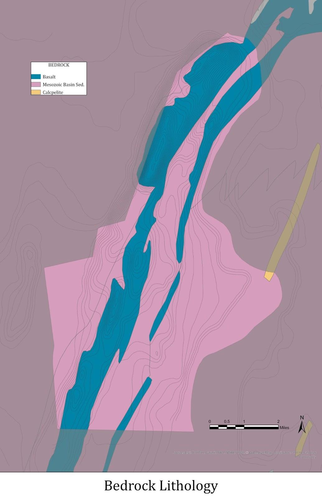
The geological processes of Holyoke’s prehistoric past left behind igneous rock (basalt) primarily along the contours of the current Mount Tom-East Mountain range and sedimentary rocks as the underlying bedrock of the remainder of the city. Glacial grinding exposed some of the volcanic basalts, but glacial deposits left coarse and thick till over most of the city, including granite and quartz erratics transported from farther north (Map 9) The nutrient-rich bedrock, where exposed, helps support unique plant communities that contribute to the ecological diversity of Holyoke.
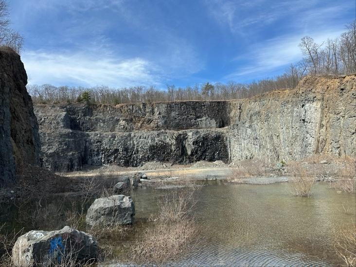
In the 1980s, a quarry began extracting some of this basalt from the east side of Little Tom Mountain to convert to traprock. The quarry closed in 2012, and in 2022, the Massachusetts Department of Conservation and Recreation acquired the 17-acre quarry and the nearby former ski area for $900,001. The state plans to preserve the site, restrict vehicle access to the quarry, and install a guardrail to protect the public (Johnson, 2021). While access is restricted, trails from the Mt.
Tom State Reservation run close to the quarry, and informal uses have been observed, including the filming of a music video as well as the use of ATVs and other vehicles.
FORMER QUARRY SITE ON MT. TOM
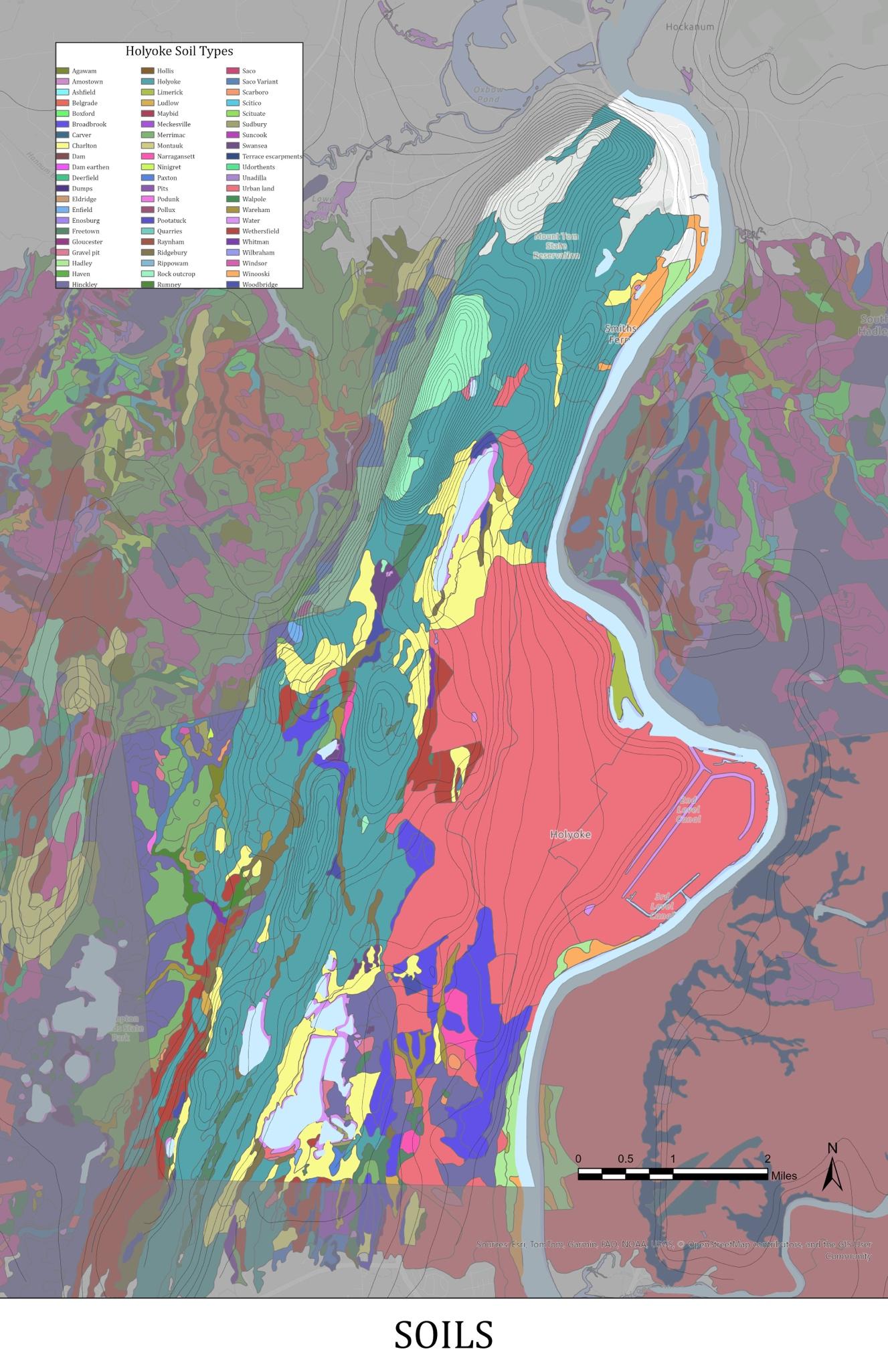
Soils
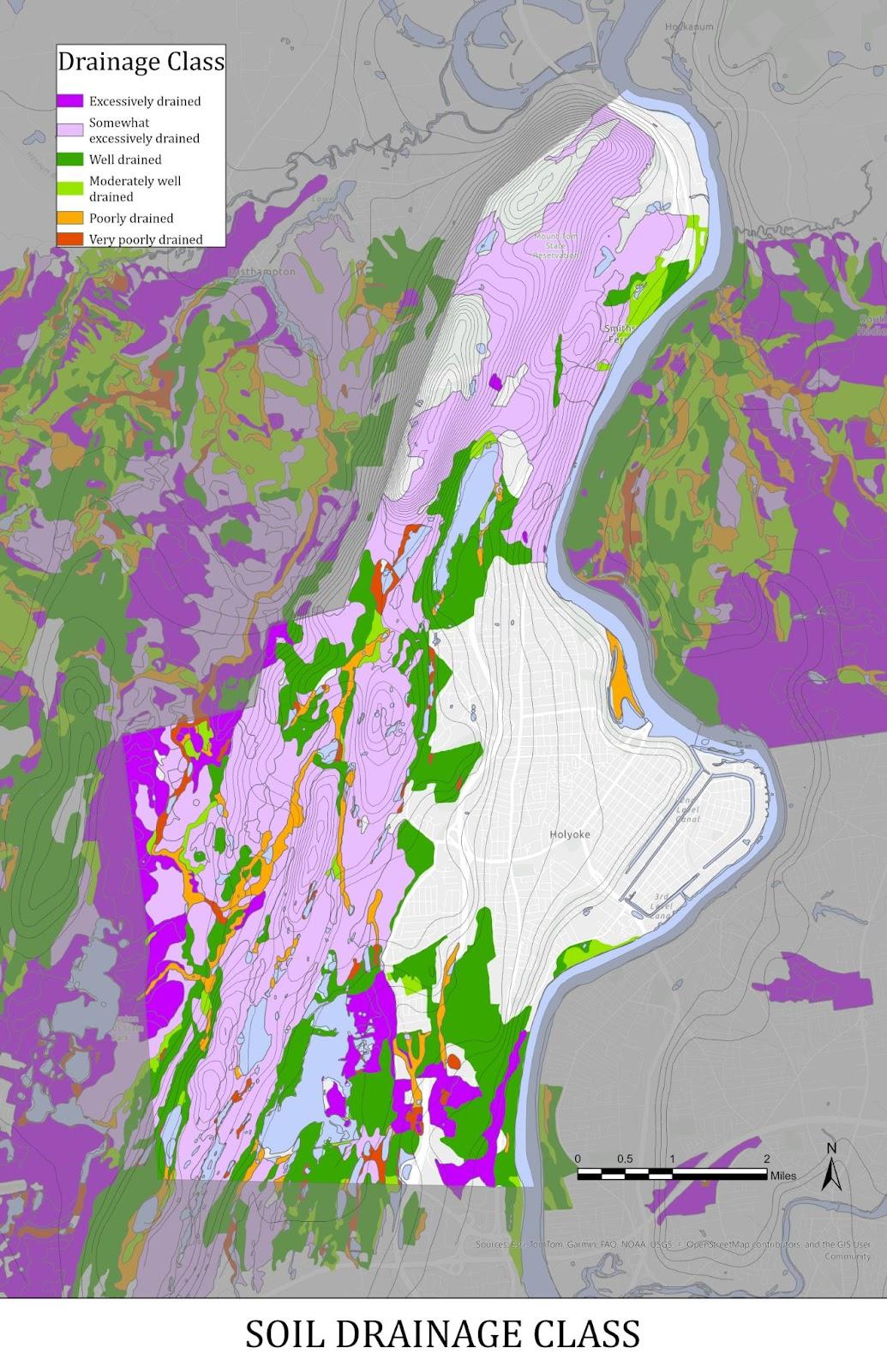
Soils in Holyoke generally derive from alluvial sediments or glacial till deposited by the receding glacier and include more than 90 distinct soil types (Map 11 and Appendix D Table 1) Sediment from glacial Lake Hitchcock and alluvial deposits from the Connecticut River created rich agricultural soils throughout the Connecticut River Valley. However, urban works and structures removed or altered soils in three-quarters of the city of Holyoke east of the mountain range, rendering them what the USDA calls “urban” soils. Due to decades of industrial activity from paper and fiber mills, these soils are more likely to contain contaminants and are likely unsuitable for many agricultural uses.
Although farming has not been a primary industry in the city, prime farmland soils are present in Holyoke along the Connecticut River in the southeast and northeast. Farmland of statewide significance appears around the prime soils in far west Holyoke, surrounding the Ashley and Whiting Street Reservoirs, and in the flatter portions of the Ingleside neighborhood. Many of these areas are being actively farmed by residents and organizations interested in locally grown food and specialty produce.
Courtesy of Santiago Fernandez
MAP
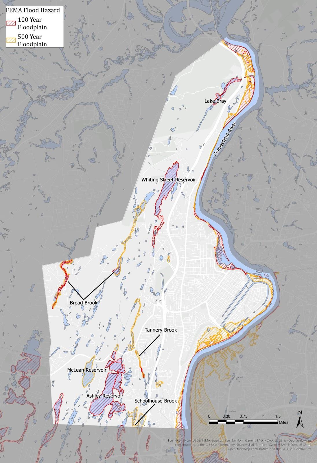
Parts of the city contain hydric or flood-prone soils, which severely limit on-site sewage disposal systems. Much of the area between Mount Tom and the river is already built upon or is unavailable for development due to steep or flood-prone soils (Map 10). Areas along the Mount Tom-East Mountain spine that are not conserved cannot be significantly developed without extraordinary expense or environmental hazard due to rocky outcrops. What remains is the western and southern portion of the city, where significant agricultural soil has been identified. At the same time, a large amount of the city’s prime agricultural soil has already been developed. A few remaining parcels containing prime agricultural soils could be targeted for preservation efforts.
4B. L ANDSCAPE C HARACTER
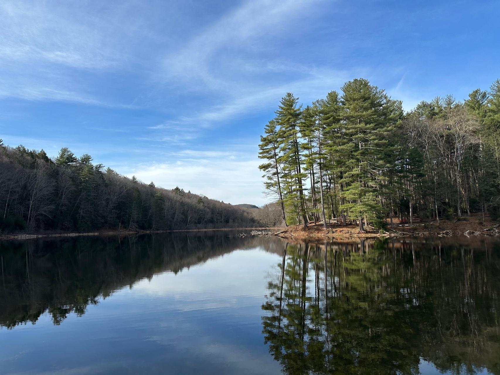
The two most dominant landscape features in Holyoke are the Connecticut River and the Mount Tom Range. Both features have influenced human use and development patterns. The mountainous terrain of the western part of the city limited development, while the flatter terrain of the eastern side abutting the Connecticut River made it more feasible for concentrated development.
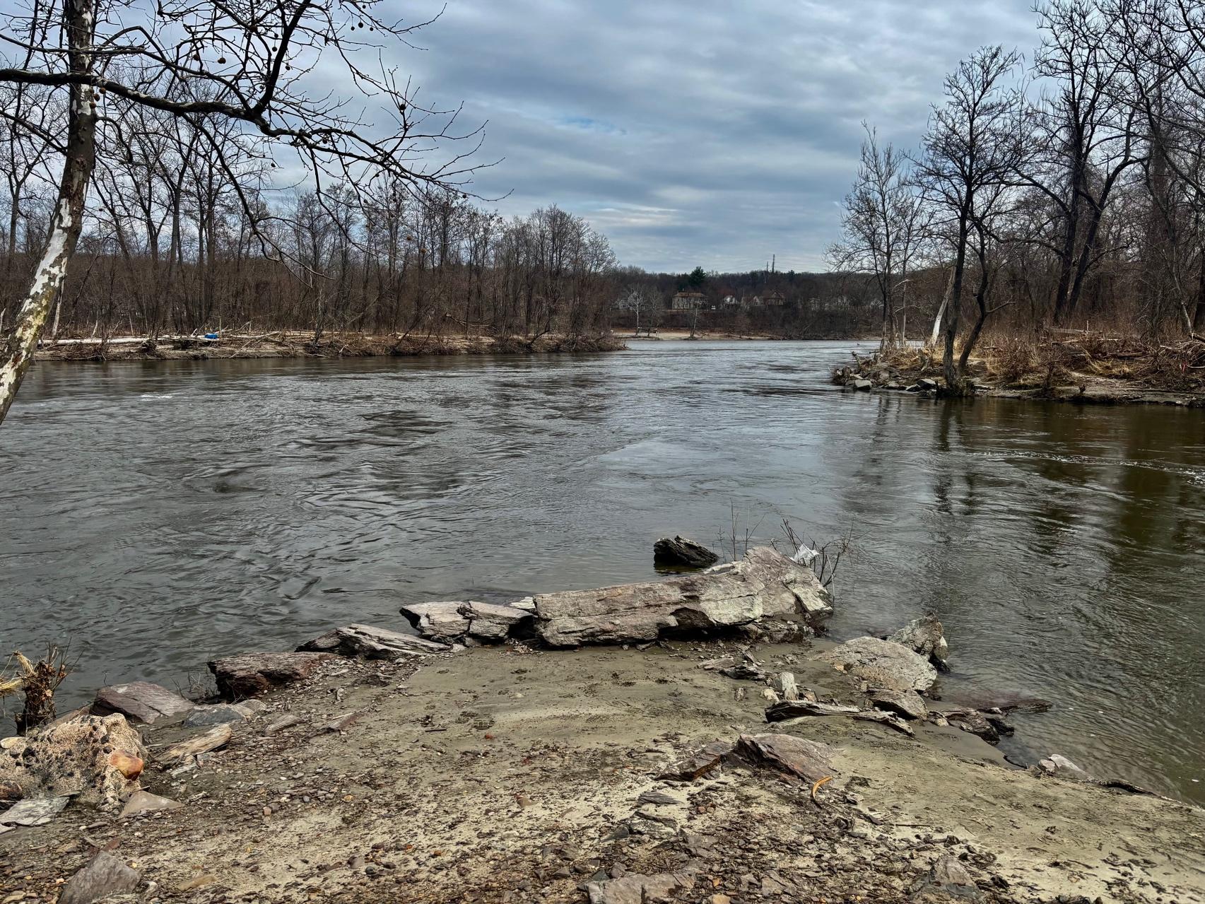
The Connecticut River defines the eastern border of Holyoke, flowing north to south for about 15 miles along the city’s riverbank. The river provides opportunities for fishing, boating, and swimming. Public access to the river is limited to a few points along the river, including Slim Shad Point, Jones Ferry Landing, and the Dinosaur Footprints. Although the Dinosaur Footprints are along the riverbank, the railroad restricts direct legal access to the water. Infrastructure and private land ownership are the two biggest impediments to accessing the river, while water quality is a fluctuating barrier. Residents have expressed interest in developing safe and legal access points to this rich resource.
The creation of the South Hadley Falls Dam and the canal systems that run through the downtown area led to development and industry in the flatter areas along historic floodplains. The dam, floodwalls, and levees changed the hydrological patterns of the
Connecticut River. The controlled floodway and canal system supported increased development around the canals but limits the ecological functions of the river and riparian boundaries. Although included in the historical industrial plan for the city, open spaces such as parks in the downtown and industrial areas are typically smaller in size compared to the public open spaces within the steeper, more mountainous areas of western Holyoke due to the increased development.
The Mount Tom Range has six peaks with the highest reaching over 1,200 feet. The north-south oriented range encompasses around 2,000 acres of conservation land which offers scenic views and recreational opportunities. The high cliffs made from basalt are part of the Metacomet Range, which spans from Long Island Sound to the Massachusetts and Vermont border. The New England National Scenic Trail, formerly known as the MetacometMonadnock Trail, traverses the Mount Tom Range. Including this thru trail, there are about 22 miles of hiking trails, which are also used seasonally for snowshoeing and cross country skiing. The hiking trails connect to scenic views of the valley. The range is also a destination for bird watching. These steep forested areas provide migratory and nesting habitats for reptiles, amphibians, and birds, including rare species.
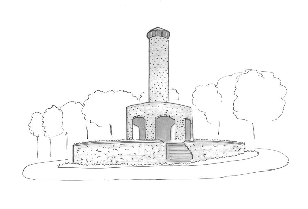
Scott Tower in Anniversary Hill Park provides views of Mount Tom and overlooks downtown Holyoke. Anniversary Hill Park was created downslope of East Mountain to celebrate the fiftieth anniversary of Holyoke. Using stone from the park, Scott Tower was built as a Works Progress Administration
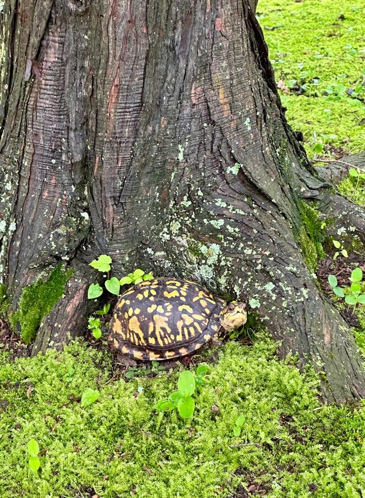
BOX TURTL
Courtesy of Santiago Fernandez
(WPA) project by the Civilian Conservation Corps in 1940. In addition to the tower, the CCC built a network of trails, stone steps, and footbridges throughout Anniversary Hill Park. Construction of Interstate 91 through Anniversary Hill Park in the 1960s led to a decline in public use of the park. As a result of the highway development, the tower is accessible by a mile-long paved road which is closed to vehicular traffic. Restoration efforts of the park began in 2021, with 14.1 acres of forested land being added to the park and improvements to the trail system. There are also plans to renovate the graffiti-covered Scott Tower (City of Holyoke, 2023).
In downtown Holyoke, Pulaski Park overlooks the Connecticut River and dam with views of the Mount Tom Range. The park sits atop a steep embankment held by a concrete retaining wall. There are four lookout spots with benches. Currently the views are limited by the vegetation which has grown up on the embankment sloping down to the river.
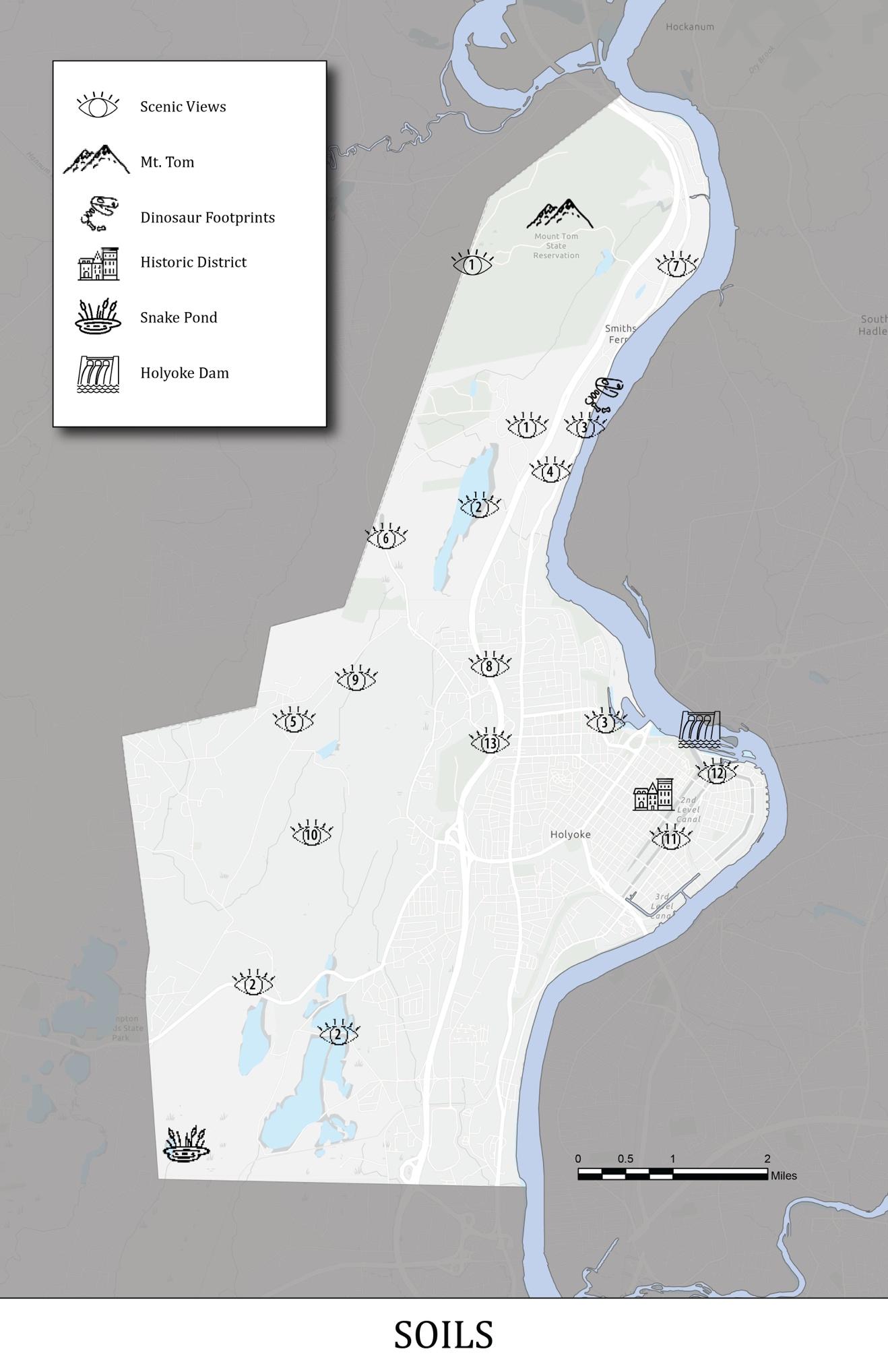
The closest views of the Connecticut River are accessible seasonally at the Dinosaur Footprints and Slim Shad Point, with Jones Ferry Landing providing year-round scenic views of the river. Starting at Heritage State Park, the four-mile Holyoke Heritage Trail provides a scenic and historical tour of downtown Holyoke. Visitors can walk, bike, or drive to see the 16 stops along the trail. Self-guided tours can be done year-round. An annual free public tour and private tours throughout the year are provided by Historical Tours of Greater Holyoke (Comeau, 2024).
Other scenic views include the public art murals, primarily in downtown Holyoke, painted on business and old mill buildings. The murals were instituted by the non-profit group Beyond Walls, which strives to “enhance the physical landscape, drive positive economic change and bolster community engagement” through public art (Beyond Walls, 2024). All of the 21 murals are accessible and free to the general public.
4C. W ATER R ESOURCES
Holyoke, Massachusetts, is home to a variety of natural water features, including rivers, lakes, and wetlands, which play a crucial role in the city's environment and community life. These water resources support local ecosystems, provide recreational opportunities, and contribute to the overall beauty of the area. Efforts to preserve and protect these waters are essential for maintaining their health and ensuring they continue to benefit residents and wildlife alike.
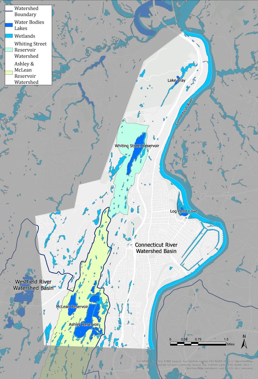
Watersheds
The majority of Holyoke lies within the Connecticut River major basin. The southwestern corner of Holyoke lies within the Westfield River major basin, which drains into the Connecticut River south of Holyoke in West Springfield. The Connecticut River Conservancy (CRC) is a non-profit organization with a mission to restore and advocate for clean water and healthy habitats in the Connecticut River watershed throughout Vermont, New Hampshire, Massachusetts, and Connecticut. The CRC works on river restoration, dam removal, and invasive species management, and monitors water quality and migratory fish runs. The CRC coordinates an annual Sea to Source Cleanup with volunteers. The CRC is also a member of the collaborative that maintains the Connecticut River Paddlers’ Trail. The Paddler’s Trail is a series of river access points and primitive campsites along the entirety of the Connecticut River. Holyoke has an access point at Jones Ferry Landing with a campsite available for paddlers provided by Holyoke Rows located next to the landing (Connecticut River Conservancy, 2024). The Westfield River Watershed Association (WRWA) is a non-profit organization focused on the Westfield River watershed. The WRWA’s primary
Courtesy of Santiago Fernandez
goals are wildlife protection, civic engagement, and community conversations all led by scientific research. Although the Westfield River does not flow through Holyoke, it provides opportunities for outdoor recreation within driving distance of Holyoke. The WRWA also has volunteer opportunities for river clean ups, an annual Canoe and Kayak cruise, and fly-fishing clinics (Westfield River Watershed Association, 2025).
Surface Water
The most significant surface water feature in Holyoke is the Connecticut River along the city’s eastern boundary. The river provides aesthetic and recreational value with opportunities for photography, birding, and observing nature. Pulaski Park provides views of the river and dam, but the scenic value is diminished by overgrown vegetation along the edge of the park overlooking the river. The trail atop the levee in Springdale Park provides views of the river in winter and has limited views due to tree foliage in the summer. Other recreation activities on the Connecticut River include boating and fishing with access limited to a few points. Below the dam, Slim Shad Point provides seasonal access to the river for fishing. This access point is fully ADA accessible. Jones Ferry Landing in southern Holyoke allows boat access and fishing. The Massachusetts Department of Environmental Protection classifies the Connecticut River as a Category 5 impaired waterbody. Fish consumption is not supported due to PCBs found in fish tissue. Primary contact (swimming) and secondary contact (boating) can be limited due to the presence of E.coli when combined sewer overflows may discharge into the river during heavy rainstorms.
The man-made canals throughout downtown Holyoke are accessible to the residents of Holyoke in the highest population density area. Although swimming, boating, and fishing are not allowed, the canals do have scenic, historic, and cultural value. Walkways run along the canals and Heritage State Park abuts one of the canals.
Located in the Mount Tom State Reservation, Lake Bray allows fishing, canoeing, and ice skating. Trails surround the 10 acre lake and connect to other trail networks and picnic areas. Part of the trail around the lake is wheelchair accessible. The
Massachusetts DEP classification for the lake is 4C, meaning it has impairments not caused by pollutants. The lake is impaired by non-native curlyleaf pondweed and water chestnut. Fish consumption has not been assessed, but reduced oxygen levels from non-native plants and silt from the confluence of the Trout and Cascade Brooks may limit the amount of fish and other aquatic species in the lake.
Holyoke has three surface water supply sources located in the western part of the city, but Holyoke’s primary source of drinking water comes from the Tighe-Carmody Reservoir in Southampton. Water from Tighe-Carmody is mixed with water from Maclean Reservoir, which is the secondary surface water supply source for Holyoke. Ashley Reservoir is a consecutive water supply source that can be pumped into Maclean Reservoir and the Whiting Street Reservoir is an emergency backup water supply source. Holyoke Water Works (HWW) operates and maintains the reservoirs. HWW also owns and manages about 7,000 acres of drainage area around all four reservoirs to protect the water quality. Trees and vegetation buffers around water supply sources help filter water and prevent erosion within the watershed. Maclean Reservoir has no public access, while Ashley Reservoir and Whiting Street Reservoir have limited public access. Restrictions on the reservoirs and surrounding land ensure a safe, potable water supply. Recreational activities allowed around the reservoirs on designated trails and roadways include hiking, walking, photography, birding, and observing nature (City of Holyoke, 2024). Although any type of contact with the water is prohibited, water bodies can mitigate surrounding temperatures, which can offer respite from heat in hotter months for visitors. Access to these natural areas can foster an appreciation for nature which can improve public understanding of the need to protect these water sources.
Image by Whit Russell
Flood Hazard Areas
The FEMA-identified flood zones in Holyoke are concentrated around water bodies. Land abutting the Connecticut River, brooks and streams, and areas around Holyoke’s reservoirs are the most vulnerable to flooding.
Holyoke has a FEMA-designated 100-year floodplain in several areas of the city. These areas include land along the Connecticut River in the Smith’s Ferry, Springdale, and Ingleside neighborhoods; and around Lake Bray, Whiting Street Reservoir, Ashley Reservoir, Broad Brook, and Tannery Brook. Springdale Park and Land of Providence both fall within the 100-year floodplain. FEMA’s 500-year floodplain zones show the potential for additional flooding along parts of the Connecticut River and extended portions of Broad Book, Schoolhouse Brook, and Tannery Brook (See Map 16). Maclean Reservoir also has the potential for flooding. Reduced risk of flooding in the Downtown, Flats, and Springdale neighborhoods is attributed to flood control systems consisting of concrete flood walls and earthen dams. Without this flood control system maintained by the DPW, much of the areas inland of these control structures would be subject to increased periodic flooding.
Wetlands
Holyoke contains approximately 605 acres of Bordering Vegetated Wetlands according to the 2004 release from the DEP. Many of the wetlands fall within protected open space parcels. Some of the wetlands in Holyoke include Log Pond Cove, Snake Pond, and perennial streams such as Tannery Brook, Broad Brook, Green Brook, Paucatuck Brook, Bray Brook, Serendipity Brook, Barry Brook, and Whiting Brook. The Massachusetts Wetlands Protection Act defines different types of inland wetlands and standards for their protection. The different types of regulated lands include riverfront areas, bordering vegetated wetlands, land under water bodies, banks, and land subject to flooding. In Massachusetts, most wetland protection is regulated by each municipality's Conservation Commission. Holyoke’s Wetlands Protection Ordinance and Regulation was updated in 2013 for the purpose of protecting public and private water supply; protecting groundwater; flood control;
erosion, and sediment control; storm damage prevention; water pollution prevention; protection of wildlife and wildlife habitat; protection of endangered species and endangered species habitat, protection of fisheries; protection of ecological integrity; and protection of ecosystem services (City of Holyoke, 2013)
4D. V EGETATION
Half of Holyoke consists of a forested band running north to south along the western border of the municipality. This band features northern hardwoods, hemlock, and white pine, representative of the flora found in western Massachusetts. The low canopy cover in eastern Holyoke prompted the city to start a tree-planting program, particularly in Environmental Justice community areas. Along the ridge and the Connecticut River, rare plants, forests, and plant communities can still be found and should continue to be protected.
Natural Community Patterns and Urban
Landscape
Holyoke has approximately 7,000 acres of forested land, comprising about 50 percent of the city, primarily along the Mount Tom-East Mountain range. The range contains most of this forested area, which is mostly owned by the City of Holyoke, MassWildlife, and the DCR. The forest along the mountain range consists of large, continuous blocks running north-south through the city. The varying topography, mineral-rich basalt bedrock exposed by glacial scouring, and other glacial processes have created diverse soils along the range, supporting a wide variety of forest and herbaceous plant communities. Over 400 plant species from more than 70 families have been identified on Mount Tom alone (Mount Tom Range Commission).
To the east of the mountain range, extensively developed land features no prominent plant community and sparse vegetation. Municipal policies and development plans aimed at directing future growth eastward will help protect the natural resources and forested character of the city’s expansive open space parcels.
The updated NHESP data layers features five natural communities in Holyoke (Map 13). Natural communities consist of species that frequently coexist in specific environmental conditions. These community types are found in areas with similar chemistry, soil, moisture, slopes, temperature, and other physical factors. In each community, certain species, especially plants, are found together in similar structures and proportions. Different natural communities in Holyoke are often features of attractive or popular public trails like the New England National Scenic Trail.
Northern Hardwoods - Hemlock - White Pine Forest
Dominant species in this community include sugar maple, white ash, yellow birch, American beech, black cherry, red oak, bitternut hickory, eastern hemlock, and white pine. This ecosystem thrives over different landforms and elevations. The shrub layer is relatively sparse, with plants like hobblebush, striped maple, red-berried elderberry, and honeysuckle. The herbaceous layer is rich in ferns, clubmosses, and ephemeral wildflowers like Canada mayflower and white wood aster. Like many other forests in the state, hemlock forests are threatened by the spread of wooly adelgid and hemlock scale, slowly changing the composition of these ecosystems. Ash and beech trees have also come under threat from emerald ash borer and beech leaf disease, respectively. Invasive plants like bittersweet, burning bush, and barberry threaten forest biodiversity in these ecosystems as well. NHESP identifies these communities primarily in the southernmost part of Holyoke in East Mountain.
Hickory - Hop Hornbeam Forest/Woodland
These communities occur on slopes with shallow soils. They predominantly feature hickory species, have a very sparse shrub layer that is devoid of Ericaceous shrubs (blueberry family), and have nearly uninterrupted cover of graminoids like grasses and sedges. The Hickory-Hop Hornbeam
LARGE HEMLOCK IN GLOUTAK WOODS
Forest/Woodland exhibits a park-like appearance, characterized by its sparse shrub layer and notable sedge understory. In these forests, hickories primarily dominate the canopy, while hop hornbeam and dogwoods are in the sub-canopy. Red oaks may or may not be present in the canopy but can be found in the surrounding forests. These communities are also associated with prescribed fires. Small pockets can be found on east-facing slopes in the Mt. Tom State Reservation
Circumneutral Rocky Summit/Rock Outcrop Community
Sparsely vegetated Circumneutral Rocky Summit/Rock Outcrop Communities are found on exposed, non-acidic bedrock. These outcrops typically host grasses, sedges, and forbs, while shrubs like Carolina rose and bearberry are mostly located at the edges. Red cedar may also be present. This community is often connected to hickory-hop hornbeam or sugar maple-oak forests. In Holyoke, there are small pockets in the Mt. Tom State Reservation and larger areas in the East Mountain Wildlife Management Area.
Courtesy of Santiago Fernandez
Sugar Maple - Oak - Hickory Forest
This deciduous forest is characterized by sugar maple and white ash, accompanied by scattered basswoods, a variety of oaks, and hickories. Broadleaved woodland sedges are also characteristic. Due to climate change and invasive species pressure from insect pests, the composition of these ecosystems is under threat. These communities are primarily found in the Mt. Tom State Reservation.
Major-river Floodplain Forest
These natural ecosystems endure significant flooding from fast-moving waters that erode the surface. They typically lack a shrub layer. The predominant soils are sandy loams, which do not have a surface organic layer. Silver maple, cottonwood, and elm are the tree species most commonly linked to these environments. In Holyoke, they are predominantly located in the southern area of the city near the Connecticut River.
Northeastern Dry Mesic Forest
The 2018 OSRP also identified Mixed Oak Forests/Woodlands as a prominent natural community within Holyoke, but they are not present in updated NHESP natural communities’ data layers. They are identified in the Nature Conservancy’s Northeast Habitat Map as Northeastern Dry Mesic Forest.
Found primarily in drier areas along the Mount Tom-East Mountain range corridor, mixed oak forests mainly consist of deciduous oak species such as chestnut, white, red, black, and scarlet oak. Typical species include black and white birches, red maple, and white pine. The understory features gray birch, striped maple, mountain maple, witch hazel, shadbush, and chestnut. In the lower herbaceous levels, one may encounter sparse or dense blueberries, huckleberry, mountain laurel, wild sarsaparilla, and Pennsylvania sedge. This community faces threats due to its vulnerability to fire.
Urban Forestry
In contrast to Holyoke’s forested lands on the mountain range, more urban areas have historically had more limited tree coverage. In the last decade, the city has undertaken significant efforts to increase urban canopy cover. In 2013, Holyoke was the recipient of the Environmental Justice Urban Forestry Challenge Grant, which aims to enhance tree canopy coverage in Environmental Justice communities. This initiative is supported by the Massachusetts Greening the Gateway Cities program and funded by the Davey Resource Group (DCR).
In 2021, the City of Holyoke collaborated with DCR, Community Circle, and Fair Forests Consulting to develop a holistic strategy aimed at conserving and increasing the urban tree population. The Urban Forest Equity planning initiative featured a public tree inventory to assess the current urban canopy and a series of community forums and activities to identify local priorities regarding Holyoke's trees. The city crafted its inaugural Urban Forest Equity Plan (UFEP) with support from the Massachusetts Municipal Vulnerability Preparedness (MVP) program. This plan primarily targets four downtown neighborhoods Churchill, Downtown, South Holyoke, and The Flats that were part of the original city layout and currently face significant socioeconomic challenges. As of January 22, 2024, the DCR has planted 2,456 trees out of its original goal of 2,400. The trees that have been planted are species that can withstand urban conditions.
Other vegetated areas in Holyoke are primarily public parks and other managed spaces that require regular maintenance, such as lawns, parklands, sports fields, and cemeteries. These represent urban plant communities selected primarily for their ornamental value.
Abandoned lots, spaces near train tracks, and other fragmented, inaccessible areas are currently challenging to manage. However, they could serve as valuable resources for future open-space projects focused on connectivity, urban agriculture, forestry, and other uses. Plant communities here are often a mix of natural communities with a high percentage of invasive plant species.
Biomap
In November 2022, MassWildlife and The Nature Conservancy introduced the updated BioMap tool. This online portal offers access to the most recent scientific data and resources, assisting state and local governments, land trusts, non-governmental organizations, and various conservation partners in strategically planning projects aimed at preserving wildlife and their habitats. The newest iteration of BioMap incorporates over 40 years of thoroughly documented records on rare species and natural communities from MassWildlife and is meant to be continuously updated.
Rare Plant Species
NHESP’s rare species tool identifies forty MESAlisted vascular plant species that are endangered, threatened, or of special concern based on population trends, threats to their survival, and rarity across the state. Rare species habitat is primarily found at higher elevations in Holyoke as well as in the western side of the city where development is more sparse. Notable rare species include black cohosh (Actaea racemosa) and whorled milkweed (Asclepias verticillata). See Appendix C, Table 1 for a full list of species.
Threats to Natural Communities from Climate Change
As in all of the northeast, Holyoke’s plant communities are under pressure from the shifts in temperature, intensity of weather events, and invasive pest and plant ranges. These changes may result in increased precipitation intensity, more extended periods of drought, and warmer temperatures, which might reduce the ability of certain plant species to thrive. This includes many of the wetlands and vernal pools in Holyoke, which are vulnerable to drought and changes in precipitation patterns. The City can approach ecosystem management with a focus on the areas of high priority identified by Biomap (see Map 13 and Section 4F.) and minimize threats to the healthy and undisturbed plant communities that are most resilient to the impacts of climate change. Large and interconnected wildlands protected on the Mt. Tom
Range may support migration of some species due to climate change
4E. F ISHERIES AND W ILDLIFE
Holyoke, Massachusetts, is home to a rich diversity of wildlife, with over 240 species of vertebrates identified within the city’s boundaries, including rare and endangered species such as bald eagles and peregrine falcons. The city’s natural landscapes, including the Mount Tom-East Mountain range and the Connecticut River, provide essential habitats and wildlife corridors for various species. Vernal pools, rare species habitats, and protected lands are critical for biodiversity conservation in Holyoke. Efforts to protect these areas are crucial, as they support a wide range of plants and animals, some of which are threatened or endangered. Additionally, the city’s proximity to the Connecticut River and the Mount Tom range makes it a significant area for wildlife migration, offering opportunities for observation and conservation.
Inventory
Approximately 242 species of vertebrates have been identified within Holyoke’s boundaries. Over 100 species of birds have been identified, including bald eagles and peregrine falcons, 21 species of amphibians including spotted salamanders and wood frogs, 42 species of mammals like American black bear and bobcat, 18 species of reptiles such as the timber rattlesnake and eastern box turtle, 29 species of fish including anadromous fish like American shad and freshwater fish like brook trout (Holyoke Gas and Electric, 2025).
Residents and visitors have opportunities to observe many of these species. The Cornell Ornithology Lab’s eBird app has identified more than ten birding hotspots in Holyoke including a few locations on Mount Tom State Reservation, McNulty Park, Pulaski Park, and Heritage Park (eBird, 2025). Holyoke Gas and Electric allows visitors to watch migrating fish at the Robert E. Barrett Fishway with underwater viewing windows as fish travel up the two elevators to get over the dam.
MAP 14: VERNAL POOLS AND CORE HABITAT
The state recognizes most of west Holyoke as containing land critical to many of these species and the resilience of those species’ natural habitats. The same topography that creates diverse conditions for a range of plant communities also discourages human disturbance, allowing for large tracts of unsettled land the length of the Mount Tom-East Mountain range. These large landscape blocks, minimally impacted by development, may serve as a wildlife corridor for large mammals and migrating birds, as well as for smaller mammals, reptiles, and amphibians who migrate short distances annually. MassWildlife’s Natural Heritage and Endangered Species Program (NHESP) is responsible for the conservation and protection of the state’s freshwater fish and wildlife, including endangered and rare species. MassWildlife restores, protects, and manages land for wildlife to thrive and for people to enjoy.
Vernal Pools
Vernal pools are temporary freshwater bodies that provide critical breeding habitat for many vertebrate and invertebrate wildlife species. They are defined as basin depressions where water persists for at least two months of the spring and reproducing fish populations do not survive. Vernal pools can be of varying sizes and depths. They are found across the landscape, anywhere that small woodland depressions, swales, or kettle holes collect spring runoff or intercept seasonal high groundwater or river overflow in floodplain forests. Many species of amphibians and vertebrates, such as the threatened marble salamander found in Holyoke, are completely dependent on vernal pools to reproduce and the loss of vernal pools can endanger entire populations of these species. NHESP has certified the location of vernal pools statewide through ground reconnaissance, as well as predicted the location of others based on interpretation of aerial photographs. There are 62 certified vernal pools throughout Holyoke, some within two distinct clusters, or vernal cores, in the north and south ends of the East Mountain range. An additional 30 or more potential vernal pools are scattered more broadly across Holyoke, including in the western residential areas and along the Connecticut River (MassGIS 2022). According to NHESP, clusters indicate particularly good habitat
for species because they ensure alternative habitat options if one or more pools are compromised and slightly different conditions in each provide slight variety for different species’ preferred habitat. Certified vernal pools are protected by the Massachusetts Wetlands Protection Act and by additional state and federal regulations. The City of Holyoke Wetlands Protection Regulations protects vernal pools regardless of whether they are certified through the state Isolated Land Subject to Flooding performance guidelines.
Rare, Threatened, and Endangered Species
Holyoke is remarkably rich in rare plant and animal species. NHESP has noted that the Mount Tom-East Mountain range is one of the most ecologically significant rare species localities within the Commonwealth. The Silvio O’Conte National Fish and Wildlife Refuge Action Plan considers the Mount Tom range to be a high priority Special Focus Area for protection given the rare species habitat, the extent of contiguous habitat types, and the available habitat for migratory land birds. About 48 percent of Holyoke’s landscape is designated as Priority or Estimated Rare Species Habitat by NHESP. This priority habitat is primarily found in the southwest corner of the city, along the range, along the Connecticut River, and in a block of land between the river and Little Tom Mountain. The areas designated Priority Habitat are protected by the Massachusetts Endangered Species Act (MESA), which requires NHESP review of projects located within Priority Habitat. In recent years, several projects have been proposed within Priority Habitat for which NHESP requested a Conservation Restriction on significant areas of land around the project site, thus increasing the amount of protected land in the city.
Holyoke is especially rich in rare reptiles and amphibians, with virtually every non-marine species known in the state represented in the city. Ten vertebrates, eleven invertebrates, thirty-two plants, and two rare natural community types are included in the Natural Heritage Program database.
Two of the more spectacular threatened and endangered animal species found in the Commonwealth can be encountered in Holyoke: bald eagles and peregrine falcons. Bald eagles nest along the Connecticut River in Northampton and West Springfield and use areas such as the river to hunt. Peregrine falcons, which nest in Springfield, in the Holyoke City Hall Clock Tower, and on bluffs in the range, can also be seen migrating and wintering along Mount Tom and hunting pigeons downtown. Birding opportunities can be found throughout Holyoke beyond conservation areas.
Holyoke is fortunate to have such numbers of rare species and habitats within its boundaries. Some of the unprotected parcels that fall within the BioMap areas are parcels already identified by the City as high priority for watershed protection. Lands that represent both ecological and watershed values become high priority for protection, especially when they connect to already protected and/or undevelopable land.
Core Habitats and Critical Natural Landscapes
MassWildlife and the Massachusetts Chapter of The Nature Conservancy (TNC) collaborate to guide conservation efforts to protect the diversity of species and natural ecosystems in Massachusetts. The BioMap tool developed by these two organizations helps identify priority lands and waters for conserving biological diversity. The two types of important habitat outlined by the BioMap are Core Habitat which are “areas critical for the long-term persistence or rare species, exemplary natural communities, and resilient ecosystems” and Critical Natural Landscapes which are “large landscapes minimally impacted by development and buffers to core habitats and coastal areas, both of which enhance connectivity and resilience” (MassGIS). These two components are intended for conservation planning.
BioMap identifies 7,947 acres of Core Habitat in Holyoke. Most of this land lies in the western side of the city and along the Connecticut River. BioMap identifies 5,051 acres as Core Natural Landscape, which primarily is within the Core Habitat areas. Protecting the land within Core Habitat and Critical Natural Landscapes has the potential to make a
significant impact on plant and animal species in Massachusetts.
Wildlife Corridors
The Mount Tom-East Mountain range forms an important terrestrial corridor of wildlife habitat running through western Holyoke. This wildlife corridor continues beyond city limits to the Mount Holyoke Range to the northeast and Bear Hole Watershed area to the south. At the regional scale, the range as a whole is part of a wildlife corridor that spans from the 50,000 acres of the Quabbin Reservoir area to the Westfield River, a federally recognized Wild and Scenic River whose headwaters start in the Berkshire hills (Novak and Corbin 13). The range aids birds and large mammals on the move regionally. Large blocks of intact land uninterrupted by roads within that corridor aid the migration of smaller species, especially amphibians, between breeding and non-breeding habitats and in search of food.
Only Routes 141 and 202 cross the mountains, but the two golf courses, the telecommunication towers on the top of Mount Tom, the former quarry site, and Interstate 91 and Route 5 do also interrupt the connectivity of the landscape. The Connecticut River also imposes a barrier to connectivity between the Mount Tom and Mount Holyoke Ranges for certain species.
Mass Audubon has identified Mount Tom, East Mountain, and Mount Holyoke ranges together as an Important Bird Area. This mountain range collectively hosts an extraordinary concentration of migrating hawks during the fall. Many bird watchers congregate on the various peaks of the range to watch this migration from early September through late November. During mid-September, up to 10,000 hawks have been seen in one day passing over Goat Peak on the Mount Tom range (City of Holyoke 2013b 46). Other raptor species known to migrate over Mount Tom include turkey vulture, osprey, bald eagle, northern harrier, sharp shinned hawk, Cooper’s hawk, northern goshawk, redshouldered hawk, red-tailed hawk, American kestrel, and peregrine falcon (Mass Audubon 3).
The Connecticut River forms another major wildlife corridor for aquatic species, including aquatic mammals. In Holyoke, very little land along the Connecticut River is under protection. There is very little floodplain forest left to act as a wildlife corridor along the river except for Log Pond Cove, the Dinosaur Footprints and the Land of Providence which still contain notable floodplain forests. The Trustees of Reservations owns and protects the Dinosaur Footprints, and the Land of Providence.
The Dinosaur Footprints is an 8-acre parcel in northern Holyoke with prehistoric dinosaur footprint fossils. Sitting between Route 5 and the train tracks, with a small section between the train tracks and the water, the historical site provides a path of habitat for wildlife. The Land of Providence is in southern Holyoke just downriver from the Jones Ferry Landing. The 25-acre parcel has agricultural fields, floodplain forests, and wetlands. In addition to being an active farm, the parcel does provide habitat for wildlife. Views of the river and a picnic area are accessible to the public via trails.
Most land along the river is within the 200’ Riverfront Resource Area and/or the Bordering Land Subject to Flooding resource area and is, therefore, subject to protection under the Wetlands Protection Act. This regulatory process of helps to preserve these critical habitat areas. The Robert E. Barrett Fishway allows fish to migrate upstream around the otherwise impassable Holyoke dam. It has been successful in assisting American shad and sea lamprey to migrate upstream and less successful for Atlantic salmon (Motzkin).
4F. S CENIC R ESOURCES AND U NIQUE E NVIRONMENTS
Holyoke’s history and location at the crossroads of the Connecticut River and Mount Tom Range provide residents and visitors with a wide range of scenic resources and unique environments to enjoy. Residents value these scenic resources, which contribute to the city’s sense of place and enhance the appeal of its open spaces and recreational opportunities. From Mount Tom State Reservation to the downtown canal system and the dinosaur
footprints along the Connecticut River, the city provides a variety of experiences.
Scenic Landscapes
Holyoke’s history, varied topography, and natural resources contribute to sweeping views and scenic landscapes that are culturally important to its residents and visitors. They provide a sense of place and offer glimpses into the city’s past and possibly its future. The 2012 and 2018 OSRPs identified thirteen scenic landscapes through community engagement. These include:
1. The Mount Tom area, including the State Reservation, the former Mount Tom Ski Area on Little Tom Mountain, and Mount Tom itself, for its dominance of the skyline and its scenic vistas;
2. The Whiting Street, Ashley, and McLean Reservoirs for the scenic and natural opportunities they provide outdoor enthusiasts;
3. The Connecticut River, notably the Holyoke Dam, and views of the range from the Dinosaur Footprints Reservation, Pulaski Park, McNulty Park, and bridges;
4. The Route 5 corridor in Smith's Ferry for its views of the river and the mountains;
5. Mountain Road in west Holyoke, for its rural character and unbroken views of East Mountain;
6. The views west from Log Cabin Restaurant on Route 141, which serves as a regional attraction;
7. The views from Cedar Knob, between Route 5 and Interstate 91;
8. The changing views of the city from Interstate 91;
9. The New England National Scenic Trail along the backbone of Mount Tom and East Mountain;
10. Views from basalt bluffs along Mount Tom and East Mountain, which provide views of the Berkshires;
11. The canal system downtown, which is an engineering accomplishment that makes Holyoke unique in the area;
MAP 15: SCENIC LANDSCAPES AND UNIQUE FEATURES
12. Gatehouse Road behind the HG&E substation, with its views of the river, dam, and Mount Tom; and
13. Scott Tower at Community Field/Anniversary Hill Park, for its views of the valley.
Scenic views are abundant throughout the city, featuring well-preserved architectural gems like the classic Victorian houses on Fairfield Avenue. Holyoke's adaptive reuse of historic infrastructure has also led to notable attractions, such as Heritage State Park, located on the former site of William Skinner Silk Mill in the old city, which now offers views of the canal system and Holyoke's industrial past. Lesser-known gems include Zenner Pond on West Cherry Street and Lake Bray in the Mt. Tom State Reservation.
Maintaining views is essential to the preservation of scenic resources. Thinning trees in the railroad rightof-way below Pulaski Park in 2017 and along the steep slope adjacent to McNulty Park in 2018 reopened the excellent views of the Connecticut River, the dam, and the Mount Tom Range. In recent years, due to the difficulty of coordinating vegetation cutbacks with the MassDOT, the vegetation grew back quite vigorously blocking the views to the River. As of March 2025 the vegetation was cut back to expose the view once more.
Unusual Geological Features
Holyoke is home to several unique geological features. The city’s most well-known landmark, Mount Tom, and the East Mountain range have fascinated geologists and the public with their dramatic sheer cliffs and unique basalt rock formations. These formations are open to the public via public trails and can be seen from locations throughout the city.
Notable geologic features in Holyoke include an abundance of dinosaur fossils, notably footprints,
which were some of the first to be scientifically described. They were formed during the Early Jurassic period, around 200 million years ago, when the area that is now the Connecticut River Valley was a subtropical region rich in lakes and swamps. The Dinosaur Footprints Reservation along Route 5 is one of the more popular locations where they can still be seen in their original state. It is among the best-known locations for fossilized dinosaur footprints in the region. Managed by The Trustees, the area is protected in perpetuity and free and accessible to the public from spring through fall. Additionally, the Wistariahurst Museum houses excellent samples of dinosaur footprints extracted in the early 1900s and used to line the driveway. The Wistariahurst Museum, owned by the city, actively contributes to preserving these fossils.
Snake Pond, located in the city's southwest corner, is a kettle pond formed by melting ice trapped in glacial deposits. The pond is encircled by a bog that hosts several rare and endangered species. During low water levels, the bog can generate acidic soil conditions that foster plant communities that are less common in the area. This pond is publicly accessible via the New England Trail.
Cultural and Historic Areas
The National Register of Historic Places includes three districts, seven historic buildings, Pulaski Park, and the Holyoke Canal System. The North High Street Historic District covers the block on High Street between Lyman Street and just past Appleton Street. The Hadley Falls Company Housing District showcases mill-worker housing located on Canal, North Canal, Grover, and Lyman Streets. The Hampden Park Historic District includes Veterans’ Park and is roughly bordered by Hampden, Chestnut, Maple, and Dwight Streets. The Wistariahurst Museum, managed by the Holyoke Historical Commission, features a historic house and museum, along with formal gardens and the unique Frog Circus, created by naturalist Burlington Schurr.
In 2007, the City established a historic district on Fairfield Avenue in Ward 7 to preserve the architectural integrity of some of Holyoke’s finest Victorian architecture. The Historical Commission
has expressed interest in creating another historic district, either local or national, around Depot Square, one of the earliest commercial districts near the train depot. The local landmark inventory includes approximately 1,195 buildings and sites.
Holyoke Community College and the War Memorial Auditorium, where veteran dancer Mikhail Baryshnikov and seminal American band Fugazi have performed, are also considered essentialities and regularly offer cultural programming. Another building of historic significance, the Victory Theater, has undergone significant repairs from 2010 to 2024 and has once again become a valuable historic and artistic site in the downtown area. Other downtown cultural sites include the restored antique carousel at Holyoke Heritage State Park, the Children's Museum, and the Volleyball Hall of Fame.
The city is also home to Scott Tower, a historic Civilian Conservation Corps project. Constructed in the 1930s, this monument as well as the stairs, and bridges in Anniversary Hill Park would offer, if restored, a fantastic view of Holyoke and nearby mountains and a unique urban recreational area. Some renovations were completed in 2003 with the help of a grant from the DCR. However, additional funding is needed to restore this park and Scott Tower to wide use by city residents.
Holyoke’s adoption of the CPA in 2017 has expanded the options for historic preservation. Since CPA funds can be allocated for preservation conservation, housing, and open space, there are opportunities for these funds to be directed jointly toward preserving sites that meet historic and open space criteria. As of 2024, the CPA has completed over forty projects throughout Holyoke, ranging from essential repairs to historic infrastructure to land acquisition for open space. These projects include:
1. The acquisition of Glutak Woods Lands in 2019 with the subsequent trail development in 2022-2023;
2. The 2022 Miracle League Fully Accessible Playground at Kennedy Park which was funded in part by the Miracle League of Western Massachusetts; and
3. The Jones Point Park Upgrade in 2023/2024 which made the basketball courts usable again and added benches and seating.
In 2020, the Main Street Corridor Historic Resources Survey was conducted to document the state of the Flats and South Holyoke neighborhoods, which, at their peak in the early twentieth century, featured buildings now recognized for their unique historic importance to the city of Holyoke. Many surviving buildings remain vacant or underutilized, increasing the risk of loss. A thorough documentation process highlighted the significance of Holyoke’s built environment. The updated forms, along with National Register criteria statements, bolster the city’s economic development and downtown revitalization efforts. This process is informing the 2022 Historic Tourism Plan.
In November 2024, the Massachusetts Cultural Council designated South Holyoke and part of the Flats neighborhood as The Holyoke Puerto Rican Cultural District. This Cultural District celebrates Puerto Rican residents and everyone who lives in and visits Holyoke, enhancing cultural richness through food, art, and entertainment. The designation aims to support the revitalization of the Main Street area and hopes to attract more Latino-owned businesses to occupy vacant storefronts.
Other historic sites of cultural significance include the Land of Providence, a historic parcel in the Ingleside neighborhood. Managed by The Trustees, the land was donated by the Sisters of Providence, a religious order with deep roots in Holyoke. This parcel is currently leased by the nonprofit Nuestras Raíces, which focuses on food access and community agriculture, particularly for the Latino community in Holyoke. Adjacent to this is the Sue Ellen Panatich River Access, operated by Holyoke Rows. The historic boat launch, also known as Jones Ferry, is the only public access point to the Connecticut River in the city of Holyoke, enhancing its cultural and recreational value.
Areas of Critical Environmental Concern
Holyoke has no state-designated Areas of Critical Environmental Concern; however, the NHESP and BioMap identify many areas along the Mount TomEast Mountain range as necessary for regional ecology. With its concentration of rare and endangered species and habitats, scenic lookouts, and heavy recreational use, the range is a natural resource of regional significance. The Connecticut River is another regionally crucial natural resource because of its rare and endangered species, natural beauty, recreation potential, and valuable hydropower generation. The lowlands in western Holyoke also provide scenic beauty and isolated areas of rare and endangered species habitat and are regionally essential due to their location over the Barnes Aquifer.
4G. E NVIRONMENTAL C HALLENGES
Various environmental hazards, including brownfields and combined sewer overflow outlets along the Connecticut River, significantly impact the ecology and experience of open space and recreation in Holyoke. Previous development and land use have resulted in persistent flooding, channelized waterways, and ongoing contamination issues that require long-term planning and remediation to mitigate.
Hazardous Waste Sites and Brownfields
Hazardous waste sites are parcels of land contaminated by chemical pollutants, typically resulting from dumping or accidental leaks. Many of these sites are classified as brownfield sites, defined as properties “whose expansion, redevelopment, or reuse may be complicated by the presence or potential presence of a hazardous substance, pollutant, or contaminant” (US EPA 2018c). Holyoke has numerous abandoned or underused properties with potential brownfield issues (see Map 20). Fortunately, there are no Superfund sites in the
city these are hazardous waste locations where the contamination level necessitates federal government intervention (EPA 2018b).
The Massachusetts Department of Environmental Protection (DEP) identified 294 Waste/Reportable Release Sites, or hazardous waste sites, in the city (MA EOEEA 2017). According to the 2018 OSRP, at least ten release sites were “open,” indicating that assessment or cleanup is ongoing or needed. The DEP has also given 23 sites Activity and Use Limitations (AULs). These AULs, concentrated in the developed east especially around the industrial downtown infrastructure, limit use to prevent exposure to contaminants (typically in soil) that might compromise air or groundwater quality. In addition to known spill sites, there are many abandoned or underutilized properties throughout the city where potential environmental issues exist, and investigations have not been conducted. According to the assessor's data, Holyoke has 64 properties in tax title and 11 foreclosed properties on the market at the time of writing. Hence, brownfield remediation could provide opportunities to incorporate open space in the redevelopment of Holyoke.
In 2024, MassDEP obtained $2 million through the Brownfields Community-wide Assessment Grant for States and Tribes. This funding will facilitate environmental site assessments focusing on areas in Holyoke, Leominster, and Chelsea, along with the town of Brimfield. The funding aims to tackle contamination at the former American Thread Mill site in Holyoke. Remediating and redeveloping brownfield sites in Holyoke could positively impact the community by reintroducing properties to the tax rolls if used commercially, safeguarding public health through capping and remediation, expanding open spaces if portions of the sites are turned into parks, and facilitating job creation if businesses move in. Cleaning up brownfields for redevelopment has the capacity to improve economic and environmental conditions for Holyoke, especially for residents within the urban core near these properties. Downtown neighborhoods, where hazard sites are prevalent, are recognized as environmental justice communities.
One of the City’s most significant efforts to remediate brownfields in the last decade can be found in the rural western portion of the city. In 1924, the City took ownership via eminent domain of a parcel on Mountain Road previously used for small arms practice by the former “Voluntary Militia” (once required by state law). The National Guard was the last known property user, terminating their site use for these purposes in the 1970s. The City is in the process of removing lead, antimony, and arsenic that remained after the use of this site as a firing range ended. Cleanups to remove these hazardous materials were conducted on three pits between 2012 and 2013. No further development or clean-up has been conducted as of 2025.
Another remediated brownfield includes the Mt. Tom Coal-Fired Power Plant which after closing in 2014 was successfully remediate through the removal of over 400 tons of asbestos contaminated soils and addressing over 50 acres of on site coal ash. The site has since become a solar array and energy storage facility with a generation capacity of 7,300-megawatt hours and enough energy to power 1800 homes.
Landfills, Dumping Grounds, and Water Pollution Control Facilities
There are no active landfills in the City of Holyoke. The Holyoke Mall at Ingleside is built over a capped landfill, which was discontinued in the early 1970s. An additional municipal landfill has been inactive since the 1960s. Four additional dumping grounds within the city limits have also been deactivated as of 2023.
Holyoke’s wastewater collection system spans approximately 137 miles of sewer mains, with around 61% classified as combined sewers. The system's older sections consist of brick, concrete, and vitrified clay (VC) pipes, whereas newer areas feature reinforced concrete (RC), asbestos cement (AC), and polyvinyl chloride (PVC) pipes some parts of the system date back over a century. The city
has 14 Combined Sewer Overflows (CSOs), with twelve discharging into the Connecticut River and two into the first-level canal leading to the river. Since 2008, permanent monitoring of CSO regulators and discharge metering has been implemented. The city has made considerable strides in reducing CSOs and consistently improves its infrastructure, including the reconstruction of pumping stations and the repair of sensors for continuous water quality monitoring in the Connecticut River.
Recent projects completed in 2022 have incorporated several key interceptor sewers that collect flow from Jackson Street sewers and transport this wastewater to the City’s Water Pollution Control Facility located on Berkshire Street. In 2023, the city announced that it had entered into a consent decree with the EPA to resolve violations of the Clean Water Act and state law. The decree calls for Holyoke to take remedial action to reduce ongoing sewage discharges into the Connecticut River from the city’s sewer collection and stormwater systems. With a combined cost of $27 million, more projects are expected to follow for Springdale Park and River Terrace to continue addressing the legacy problem of CSOs in the city.
Erosion and Sedimentation
Tannery Brook is a 22.5-mile-long tributary of the Connecticut River, with its headwaters located in a wooded area northwest of Holyoke Community College. Its watershed spans approximately 1,400 acres, accounting for around ten percent of Holyoke’s total land area. The upper reaches of the brook, near the college, are primarily stable in a riparian state, according to the Conservation Commission. However, several sections in the middle and lower parts of the brook have experienced significant erosion and channelization. Extensive development and culverting in this area have led to scouring, flooding, and sedimentation on land belonging to The Trustees’ Land of Providence and commercial tenants near the intersection of Tannery Brook and Main Street, totaling several hundred thousand dollars in repairs in 2006. Aerial photos taken in September 2010 and 2017 at low flow levels
illustrate the extent of erosion and sedimentation affecting Tannery Brook, which may impact the Connecticut River. The City has not identified a suitable funding program to address the needs of this watershed. As of 2025, no projects have been undertaken at the site.
The high and steep bank of the Connecticut River around Log Pond Cove also shows considerable erosion below Lincoln Street. This site has shown signs of erosion for several decades, but the actual effects of the erosion have been minimal in terms of cutting back the bank.
The City has an Erosion and Sedimentation Control Ordinance enforced by the City Engineer to tackle active erosion and sedimentation issues. The City must closely monitor compliance with the Stormwater Pollution Prevention Plan (SWPP) requirements set by the EPA, especially during construction and development phases, to ensure that construction activities do not lead to sediment deposition in the city’s water supplies and wetlands resource areas. Additional site-specific sedimentation concerns include Broad Brook, where road sand washes into the brook, and the pool upstream of the Holyoke Dam on the Connecticut River, which receives sediment from the river’s watershed upstream.
Chronic Flooding
In 2012, FEMA issued new floodplain boundaries (Map 16). Based on this update, the City amended its flood insurance rate map in July 2013, reducing the total number of parcels in flood zones (City of Holyoke 2013b 2). Aside from the 100-year floodplain, portions of the city experience regular flooding. Areas prone to flooding during high-volume rain events but not within the 100-year floodplain are found downtown and in residential areas east of I-91 where streams are not buried. The 2025
Municipal Vulnerablility Plan identified the following areas that are prone or vulnerable to flooding:
1. Appleton Street underpass;
2. Broad Brook in West Holyoke;
3. Cabot Street near the first canal and underpass;
4. Canal Street due to overflow from the third canal;
5. Comercial Street from the first level canal and poor drainage;
6. Connecticut River near Smiths Ferry;
7. Day Brook (Green infrastructure projects currently underway);
8. Exit to Main Street from interstate 391;
9. Fairmont Street due to poor drainage;
10. Green Lakes neighborhood experiences flash flooding;
11. Green Lane, and Longfellow drive experienced flash flooding from Green Brook;
12. Holyoke Canal System during heavy rain events;
13. Jackson Street underpass;
14. Lyman Street due to over bank flooding from the canals;
15. Mosier Street underpass;
16. Mount Tom Avenue from unnamed creek at Wycoff country club;
17. Sargeant Street underpass;
18. St. Jerome Avenue due to poor drainage;
19. Skyview Street due to poor drainage;
20. Southampton Road due to undersized culvert;
21. Tannery Brook flash flooding between Meadowbrook Road and Homestead Avenue; and
22. West Franklin Street due to poor drainage.
The NOAA storm events database for Hampden County lists five flood events between 2014 and 2023. Little damage was reported during these events, however extreme river flow and rain events are likely to increase due to climate change.
MAP 16: FEMA 100 AND 500 FLOOD HAZARD IN HOLYOKE
Development Patterns
Because over 90 percent of Holyoke is already built upon or curtailed by building restrictions, the City is directing planning and funding efforts toward infill and redevelopment. Utilization of already-developed lands could reduce pressure on undeveloped sites, preserving Holyoke’s rural and natural landscapes where they exist.
Holyoke’s subdivision regulations, last updated in 1986, establish standards for streets, utilities, drainage, and vehicle use within subdivisions. It's essential to review and update these rules to support low-impact development, as integrating current best practices could enhance the alignment of city stormwater management goals with development objectives.
Surface Water Pollution
Holyoke has an abundant supply of clean surface water filtered by the forests that encircle the city’s reservoirs, providing clean, uncontaminated water to the City’s municipal drinking water customers. While surface water in lakes and ponds hasn’t faced contamination issues, according to the annual water system reports, contamination of the Connecticut River has been an issue for decades. Operations at Northeast Utilities’ power generation facilities along the Connecticut River between 1900 and 1945 dumped coal tar in the river. When HG&E took ownership of Northeast Utilities’ power operations in Holyoke, a comprehensive coal tar removal process commenced. In 2002, excavation occurred in wet and dry conditions and involved numerous municipal, state, and federal permitting agencies. In 2005, coal tar removal began on stretches of the river near Springdale Park. Additional work was completed in 2011 within the canal system to remove coal tar deposits. In the fall of 2017 and the winter of 2018, stone caps were placed over patches of coal tar in Holyoke, South Hadley, and Chicopee under DEP186-0264 in compliance with the Massachusetts Contingency Plan.
Holyoke has well-established urban development patterns, resulting in a high percentage of impervious surface concentrated downtown. Impervious surfaces increase runoff during rain
events, polluting water bodies, increase erosion, and increase the risk of flooding. In 2020 the City of Holyoke commissioned the Impervious Surface Mitigation Plan and found that 30% of the city is covered in impervious surfaces and neighborhoods have up to 70% impervious coverage. Increasing permeable surfaces enables water to penetrate during the initial rain runoff, which helps to filter out contaminants before they reach ground or surface water. To address nonpoint source pollution, the City employs a strategy encompassing enforcement, permits, education, and the construction of new infrastructure.
The City of Holyoke filed its National Pollutant Discharge Elimination System (NPDES) General Permit for Small Municipal Separate Storm Sewer Systems (MS4s) in March 2003. In compliance with the MS4, the City of Holyoke updated its Storm Water Management Program in 2024. Key elements ot the SWMP include:
1. Public education and outreach
2. Public participation in the development and implementation of the SWMP
3. Illicit discharge detection and elimination
4. Management of construction site runoff
5. Management of post-construction site runoff (development and redevelopment)
6. Good housekeeping in municipal operations.
The scope of work and the permitting requirements established in this document require the Conservation Commission to inspect all stormwater detention basins, generate public education resources, and stencil storm drains.
Holyoke’s Stormwater Ordinance, adopted in 2009, contains substantial requirements for stormwater management. According to the Pioneer Valley Green Infrastructure Plan, Holyoke fulfills all NPDES regulatory requirements except for the previously noted lack of strong low-impact development (LID) language in subdivision regulations.
Efforts by the City and community to install green infrastructure are part of a larger strategy to reduce the amount of stormwater flowing from streams into the city’s sewer system to improve the integrity of the Connecticut River watershed. These projects
include daylighting sections of Day Brook near Community Field, which has directly reduced stormwater flow from the brook into the stormwater system during peak flow events. Other green infrastructure projects, such as the rain garden at Pulaski Park, have been completed recently through public sector and public-private partnerships. The Pioneer Valley Green Infrastructure Plan identifies Depot Square and the Suffolk Parking Garage as potential locations for new public-sector projects. Green infrastructure projects and incorporating LID zoning, could reduce stormwater and wastewater pollution with the added benefit of enhancing the landscape character of the city.
Pollution has persistently plagued the Barnes Aquifer groundwater. According to the 2012 OSRP, in 1984 DEP found trichloroethylene (TCE) in a stretch of the aquifer, including in the Broad Brook basin, which contaminated a small area of drinking water wells in west Holyoke. DEP did a comprehensive investigation and identified two potentially responsible parties: Southampton Sanitary Engineering at their site at 80/82 Pequot Road, Southampton, and General Electric at two sites in west Holyoke. As part of this investigation, DEP sampled more than 400 private wells in Southampton, Easthampton, Westfield, and Holyoke and consequently installed 278 monitoring wells to identify the approximate area of the TCE contaminant plume. To reduce the risk of drinking water contamination, the City of Holyoke shut down two public wells in 1988: the Coronet Homes Water Supply and the Pequot Well.
The 2012 OSRP elaborates that in 2008, further assessment was performed, and additional investigative bedrock wells were installed in West Holyoke to test for TCE and PCBs. Although levels were very low, results indicated that these contaminants were present. Testing did identify a release from an adjacent business. Ultimately, the affected properties are connected to public water. Most recently, DEP identified the Barnes Air National Guard Base as the source of perfluorinated compounds (PFC) contamination in portions of the Barnes Aquifer in Westfield. The contamination plume has not yet been found to affect the homes estimated to be still drawing from the aquifer in West Holyoke (3). Monitoring of DEP-issued filters and
ore-filter water quality should be continued by Holyoke. At the same time, the city should seek alternative public drinking water sources for households reliant on private wells that tap into the Barnes Aquifer.
Environmental Equity
GIS analysis shows that the vast majority of residents in the urban core live within a quarter-mile walking distance to a public park. The Rock Valley, Highland Park, Whiting Farms, and Homestead Avenue neighborhoods have the most significant number of households that are not within easy walking distance of a public park. It should be noted, however, that residents of these neighborhoods are more likely to own cars and are a short drive from either Mount Tom, Ashley Reservoir, or Whiting Street Reservoir.
While there are over thirty distinct parks in the downtown area, many of these parks are small. An analysis from the 2018 OSRP showed that of the city’s open space land area by neighborhood, less than five percent of Holyoke’s total open space and park area is found in the four downtown neighborhoods. Although the abundance of parkland and open space is one of Holyoke’s greatest civic assets, the unequal distribution of parklands between neighborhoods may limit access to clean air and recreational opportunities for residents in the most densely populated parts of the city. These residents may already face elevated exposure to environmental hazards and exclusion from public ecological decision-making. Further examination of how this unequal distribution impacts residents in downtown neighborhoods could help prioritize park development and improvements in these areas.
S ECTION 5 : I NVENTORY OF L ANDS OF C ONSERVATION AND R ECREATION I NTEREST
Courtesy of Santiago Fernandez
Open Space and Protected Lands
Open space consists of a wide variety of lands, such as those in conservation; used for recreation, farmland, community gardens, greenway corridors or water supply protection; of historical significance; or temporarily protected under Chapter 61. Open space can also include unprotected forested lots, vacant lots, and brownfield sites of conservation or recreation interest. As discussed in previous sections, Holyoke is home to 59 rare plant and animal species and provides abundant passive and active recreational opportunities. These spaces and opportunities are found across the landscape, from the Connecticut River Valley floor to the rugged Mount Tom ridgetop serving as scenic destinations, priority habitat, and critical wildlife corridors.
These lands are essential in supporting local populations of plants and animals along with regional biodiversity. Moreover, their protection supports the community's resilience to the effects of climate change. An example of this is that the vegetated upland areas filter and slow stormwater that falls along the ridge, reducing flooding risk as storms strengthen. Their health is also directly tied to the health of Holyoke’s residents via numerous ecosystem services. It is thus pertinent that Holyoke prioritizes the long-term protection of critical lands. Land in Holyoke is protected via private, non-profit, and public entities.
Article 97 of the Massachusetts Constitution is a crucial legal provision for public land conservation in the Commonwealth. The article states, “The people shall have the right to clean air and water, freedom from excessive and unnecessary noise, and the natural, scenic, historic, and esthetic qualities of their environment; and the protection of the people in their right to the conservation, development and utilization of the agricultural, mineral, forest, water, air, and other natural resources is hereby declared to be a public purpose.”
The stringent legislative process around Article 97 ensures that conservation lands are not easily repurposed for commercial or industrial use. By protecting state parks, forests, and other public lands, Article 97 supports outdoor recreation,
wildlife habitats, and climate resilience. Article 97 remains a powerful tool for environmental advocates and policymakers to preserve Massachusetts’ natural landscapes for future generations. Private entities can protect land permanently by amending deeds to include a conservation restriction. Private entities can also establish temporary protection under Chapter 61.
5A. P RIVATE AND N ON - P ROFIT C ONSERVATION AND R ECREATION L AND
While public entities own most of the land designated for conservation and recreation in Holyoke, private and non-profit organizations also play a vital role in shaping Holyoke’s open space and recreational landscape. The following section discusses parcels in private ownership by individuals and businesses, as well as parcels in non-profit ownership, with the majority of lands under temporary or permanent development restrictions. Additionally, some parcels though not currently protected or designated for conservation or recreation have been identified by the City for their conservation and recreation value.
MAP 17: INVENTORY OF OPEN SPACES
Chapter 61 Parcels (Temporary Protection)
The Commonwealth of Massachusetts recognizes the significant contributions of agriculture, forestry, and certain types of outdoor recreation to the state's economy, environmental health, and scenic beauty. Privately-owned parcels designated for such uses, however, are taxed based on their assessed development value, creating a financial burden for property owners who wish to preserve these uses. To alleviate this burden, the Commonwealth enacted M.G.L. Chapter 61, which provides tax abatements for landowners who maintain their properties for agriculture, active forestry, or specific recreational uses (such as ski areas).
Chapter 61 applies to landowners with 10 or more acres in agroforestry, while Chapters 61A and 61B extend eligibility to properties of 5 acres or more in agriculture (61A) or forested recreation (61B). As of March 2025, Holyoke has thirty-one parcels enrolled in Chapter 61, totaling 427.08 acres. A breakdown of the Chapter 61 allotment types can be found in Table 5.1A, with a more detailed parcel-byparcel assessment in Appendix A, Table 1.
Under Chapter 61, landowners receive a significant reduction in property taxes for a ten-year period, as taxes are assessed based on the land’s current use rather than its development value. However, if the owner decides to sell the property during this period, the City has 120 days to exercise their right of first refusal to purchase the land. Additionally, the landowner must repay the difference between the reduced and full property tax rates for all years in which the land was enrolled in Chapter 61 leading up to purchase.
Thus, Chapter 61 does not offer permanent protection from development. In practice, municipalities rarely exercise their right of first refusal, and many properties across the Commonwealth that were once enrolled in the program have since been developed. Holyoke has never exercised this right and currently does not have formal policies or procedures to respond quickly when such opportunities arise.
Between 2005 and 2012, enrollment in Holyoke’s Chapter 61 program declined from 805 acres to 325 acres, however, by 2018 enrollment had increased again to 531 acres. For the 2025 OSRP update, Holyoke has seen an increase in enrolled parcels for a total of 743.5 acres in the program (see Table 5.1A). The City Assessor’s office can play a key role by notifying the Conservation Commission or other City entities when properties delay or terminate their enrollment, ensuring that potential conservation opportunities are not overlooked.
61 99 Limited
Chapter 61A 379.08 Limited
While Chapter 61 provides temporary tax relief to residents, it is also an important tool for the municipality in identifying land that could be permanently protected for conservation or recreation by the City or other entities. These properties already provide open space and recreational opportunities, making them strong candidates for long-term preservation. To maximize the effectiveness of the program, the 2025 OSRP update has identified key Chapter 61 parcels for acquisition if they were to come available based on NHESP habitat and ecological value, soil type, slope, watershed, abutting properties, and recreation potential (see table 5.1B and Map 18). It is recommended that Holyoke establish policies and an emergency fund that allow for a more efficient and effective response when priority parcels become available, and explore partnerships with non-profit conservation organizations that could help facilitate acquisitions, including the Kestrel Land Trust and The Trustees.
Enrollment Type Acres Protection Type
Chapter
MAP 18: PRIORITY CHAPTER 61 PARCELS
199-00-009
199-00-016
202-00-026
200-00-001
200-00-002
200-00-003
206-00-065
206-00-066
207-00-001
208-00-001
208-00-002
208-00-004
208-00-005
208-00-011
208-00-015
208-00-017
210-00-002
211-00-008
211-00-009
211-00-013
222-00-013
Abutting Conservation Commission land, agriculture soil and slope, Broad Brook, aquatic/rare species habitat None
Road access, ponds, vernal pool/rare species habitat, scenic, amenities, and facilities, abutting East Mountain WMA Holyoke Revolver Club
Road access, rare species/aquatic/vernal pool habitat, Broad Brook, and East Mountain WMA None
Prime agricultural soil and vernal pool/rare species habitat
Round Hill Farm Trust
Road access, river access, amenities, and facilities Holyoke Canoe Club
TABLE 5.1B: CHAPTER 61 PRIORITY PARCELS
Private and Non-Profit Parcels not Enrolled in Chapter 61 (No Protection)
Table 5.1 identifies 24 privately owned recreational parcels used for recreation, community gathering or other purposes in Holyoke, covering a total of 367.6 acres, that are not enrolled in Chapter 61. The Appendix A, Table 2 profiles the properties. These parcels, owned by a mix of private and non-profit organizations, serve a variety of light recreational purposes. Many are well-known leisure and entertainment venues, such as the Holyoke Country
Club, Canoe Club, and Mountain Park concert venue (no longer in operation). Other parcels are owned by civic organizations, including the Elks Club Soccer Field and the Polish National Alliance’s Pilsudski Park. The community non-profit food justice organization, Nuestras Raíces, owns or maintains several of the parcels in this classification, using them as community gardens, farms, and community gathering spaces. Additionally, the table includes properties designated for both active recreation, such as the YMCA, and passive recreation, such as private housing playgrounds.
The Trustees are the only non-profit conservation organization that owns recreational land in Holyoke. Their holdings include the Dinosaur Footprints Reservation off Northampton Street in Smith’s Ferry, one of the few in situ examples of dinosaur tracks in Massachusetts and among the rare instances worldwide showing evidence of herding behavior. As noted in the 2018 OSRP, however, the site faces ongoing threats from vandalism and highway runoff. According to the 2025 OSRP survey, members of the Holyoke community also illegally cross the railroad tracks just under the dinosaur footprints to fish along the
Connecticut River. If the issue of a railroad crossing could be resolved, the area could provide the community with public access to the Connecticut River. As things stand, there is currently no public access to the Connecticut River above the dam.
The parcels listed under this category lack legal restrictions to development. While properties such as the Boys & Girls Club, YMCA, and Dinosaur Footprints are unlikely to be repurposed, community garden sites remain especially vulnerable to development. This risk was exemplified in 2017 when the Lyman Terrace community garden was displaced due to redevelopment efforts. Without formal safeguards, similar losses could occur in the future, threatening valuable community spaces.
Private Parcels with Conservation Restrictions
Table 5.1 identifies 274.6 acres in Holyoke that are protected under conservation restrictions (CRs). A more detailed breakdown of these figures can be found in Appendix A Table 3. The Connecticut River Conservancy oversees 92.3 acres of land under CRs. Additionally, the Holyoke Conservation Commission holds CRs on 121.37 acres of privately owned land in western Holyoke.
The majority of the Conservation Commission’s CRs are on properties owned by members of the Kuzeja family. Situated above the Barnes Aquifer, these protected lands play a crucial role in preserving both habitat and water quality. To ensure compliance with CR terms, the Holyoke Conservation Commission conducts annual monitoring. When ownership changes, it is strongly recommended that new landowners receive clear guidance on the restrictions in place. A lack of awareness about CR terms can lead to unintentional violations, particularly in the early years of new ownership.
Private Cemeteries
Holyoke is home to 5 private cemeteries, totaling 120.5 acres. These cemeteries provide passive recreation opportunities for walking and contemplation in addition to their more obvious use as a burial ground. Details of these cemeteries can be found in Appendix A, Table 4.
Unprotected Private Parcels of Conservation and Recreation Value
Appendix A Table 5 details 377.7 acres of unprotected private parcels that the City of Holyoke has recognized as having conservation or recreation value. The primary focus for this section is put on the approximately 540 acres of undeveloped, privately owned land that lie within the watersheds of the City’s reservoirs. Future development on these parcels could increase the potential of erosion, reduce groundwater infiltration, and risk contamination of Holyoke’s water supply. Other parcels in this table have been identified for their
potential as public trails and greenways, downtown parks and plazas, or ongoing wildlife value.
5B. P UBLICLY O WNED C ONSERVATION AND R ECREATION P ARCELS
The majority of Holyoke’s open spaces are owned and managed by the City, as well as state and federal conservation agencies. With the exception of properties maintained by the Holyoke Parks and Recreation Department, most of these lands remain forested, with little to no road development or structural intrusion. As a result, they serve vital functions in preserving wildlife habitat, protecting water resources, maintaining scenic landscapes, and supporting passive recreation. In particular, large, unfragmented tracts owned by Holyoke Water Works, the Commonwealth, and federal agencies play a crucial role in sustaining these ecological and recreational benefits.
Municipally Owned Conservation and Recreation Parcels
In total, the City owns 3,414 acres with conservation or recreational value. Table 5.2 gives a breakdown of this acreage by City department or agency; parcels include public housing parks, city-owned playing fields and recreation facilities, cemeteries, and undeveloped parcels owned by the Conservation Commission and by the utility companies. For a complete list of Holyoke-owned conservation and recreation parcels, see Appendix A, Table 6
TABLE 5.2: MUNICIPALLY OWNED CONSERVATION AND RECREATION PARCELS
Parks and Recreation Department
The Parks and Recreation Department, a division of the Department of Public Works, is responsible for managing the majority of municipally owned public-facing properties, which encompass a diverse range of recreational facilities. These properties cover approximately 236.75 acres of maintained parkland and offer 175 distinct recreation opportunities. Since the last OSRP, 14.1 acres have been added to Anniversary Hill Park (see Table 5.2A).
Parks & Recreation Parcels Acres Protection Type Parks
upgrades to ensure that all residents of Holyoke have full and equitable access to recreational facilities
Holyoke School Department
The Holyoke School Department maintains 17 open spaces in partnership with the Parks and Rec. Department totaling 69.7 acres (see Appendix A Table 8). These properties consist of recreation fields and playgrounds.
Holyoke Housing Authority
The Holyoke Housing Authority (HHA) provides a variety of recreational opportunities at its housing developments to support the needs of residents. These amenities include play structures, play areas, passive parks, and a ball field (see Appendix A Table 9)
Holyoke Conservation Commission
Each spring and fall, the Parks Superintendent conducts a comprehensive assessment of all park facilities. The condition of each park and its individual elements is evaluated based on safety, functionality, and appearance, with ratings categorized as excellent, good, fair, or poor. Rather than providing a generalized rating for entire parks, this system identifies specific features within each park and their respective conditions. Of the 61 sites assessed, 18 contain elements rated as poor (including accessibility concerns), 19 have elements rated as fair, 37 contain features rated as good, and 14 include elements in excellent condition. Notably, 25 sites received exclusively good or excellent ratings, indicating no significant concerns. A detailed breakdown of these assessments can be found in Appendix A, Table 7 This data will guide infrastructure and facility improvements over the next seven years.
Beyond evaluating the general condition of the City’s parks as part of the Open Space and Recreation update process, the Parks Department will also conduct a detailed review of each park’s compliance with the Americans with Disabilities Act (ADA). This assessment builds upon ADA surveys conducted in 2012 and 2018, identifying necessary
The Holyoke Conservation Commission manages seven parcels totaling 105 acres across the City (See Appendix A, Table 10). While most of these lands have limited potential for passive recreation due to steep slopes or wetlands, they play a critical role in erosion control and serve as NHESP-designated priority habitats for wildlife conservation, and only some have maintained trail networks.
Since the last OSRP update, the Conservation Commission has acquired Gloutak Woods. This 51.72-acre property features a picturesque vernal pool, meandering streams, and a well-established trail system that winds through rolling uplands. Open for all-season recreation, Gloutak Woods represents a significant step forward in Holyoke’s conservation efforts, enhancing public access to natural spaces while preserving critical habitats
Look Memorial Park is a private non-profit park in Florence, MA. Open to the public since 1930, the park covers more than 150 acres. Look Park has many traditional amenities like ball fields, tennis courts, splash pads, walking paths, and pavilions. A new attraction was developed by the Garden Community. This volunteer group assists the park in maintaining the grounds by converting a 5,000 square foot portion of turf into a pollinator habitat garden. Through donations and a grant from the Hampden Hampshire Conservation District, volunteers began the project by planting over one hundred native plants and seeding a large area to create habitat to benefit pollinators and increase biodiversity within the park. After a few months of planting, butterflies, bees, wasps, and a variety of birds were present in the pollinator habitat garden. Plans for plant identification labels and a fully accessible pathway through the garden will invite visitors to enjoy the garden and have an opportunity to learn about the benefits of native plants.
Courtesy of Whit Russell
Holyoke Water Works
Holyoke Water Works (HWW) owns 2,578 acres of land in the City, primarily due to the presence and necessary watershed management of Ashley, McLean, and Whiting Street Reservoirs (see Appendix A Table 11). While Holyoke’s primary source of drinking water comes from the TigheCarmody Reservoir in Southampton, the local reservoirs are critically maintained for auxiliary purposes and support the long term resilience of the City.
48 acres of HWW holdings are dedicated to pipelines connecting the reservoirs and treatment plant, while two parcels (totaling 27.12 acres) hold former wells that once-tapped the Barnes Aquifer. Unless documentation indicates otherwise, all HWW parcels listed in the table are protected under Executive Office of Energy and Environmental Affairs (EOEEA) Article 97.
HWW maintains a long-term forestry plan focused primarily on preserving watershed health and, secondarily, on generating funds for departmental activities. Thus, it is well within the City’s interest to acquire additional watershed parcels in Holyoke as landowners choose to sell. While the in-town watersheds face few significant threats, runoff from the heavily trafficked Route 202 could potentially impact the water quality of the Ashley and McLean Reservoirs.
The City organized a committee to study current use and resource potential; and provide recommendations for future use for Whiting Street Reservoir a popular recreational area designated for emergency use as auxiliary drinking water supply. As part of its study, the Committee has recommended the emergency designation remain, prohibiting water-based recreation on the reservoir (City of Holyoke, 2022 17) .
Holyoke Gas & Electric Company
HG&E manages approximately 361.3 acres of open space throughout the City (see Appendix A, Table 12). These areas include a park, land along a pipeline in west Holyoke, the Slim Shad Point fishing access site, and the only cove along Holyoke’s bank
of the Connecticut River. In addition, HG&E owns the canals, canal banks, and a riverside strip acquired with the dam; however, these parcels are considered to serve purely utilitarian purposes and are therefore not classified as open space in the OSRP.
In the past decade, HG&E significantly expanded its portfolio with the purchase of two large parcels on Mount Tom. Initially considered as potential wind power sites, these parcels became unfeasible for such development due to Federal Aviation Administration regulations, leading instead to the construction of telecommunications facilities. For recreation, wildlife, and scenic purposes, it is recommended that the remaining portions of the parcels be placed in conservation.
A key opportunity for expanding riverfront access and recreation within walking distance of downtown Holyoke is parcel 064-00-001, owned by HG&E an abandoned railroad track along the Connecticut River. This parcel holds significant potential for redevelopment into a pedestrian path or bikeway that could link Springdale Park to Slim Shad Point.
Parcels Owned by Other Municipalities
The West Springfield Water Department owns several parcels in south Holyoke within the Bear Hole Reservoir watershed, totaling 177.4 acres (see Appendix A, Table 13). These lands play a crucial role in protecting the quality of West Springfield’s drinking water supply. Like the parcels owned by Holyoke Water Works (HWW), these properties are permanently protected from development under Article 97.
While West Springfield currently has no plans to acquire additional watershed land in Holyoke, it should be noted that several landlocked parcels near its existing holdings could be conserved to preserve the scenic landscape and wildlife corridor in west Holyoke, and expand the buffer of protected land around Snake Pond.
Federally and State-Owned Conservation and Recreation Parcels
Over the past two decades, Massachusetts conservation agencies have played a vital role in acquiring-for-protection high-priority recreation, habitat, and watershed lands in Holyoke. Their efforts have focused on contiguous parcels along the Mount Tom–East Mountain range and near the Connecticut River many of which were previously identified as priorities in earlier OSRPs. Today, the Commonwealth owns approximately 2,433 acres in the City dedicated to conservation or recreation. Table 5.3 summarizes these lands by managing agency, with notable properties including Mount Tom State Reservation, Holyoke Heritage State Park, and Holyoke Community College (see parcel breakdowns in Appendix A, Table 14).
Additionally, the U.S. Fish and Wildlife Service owns a 141-acre parcel on the side of Little Tom Mountain, which is part of the Silvio O. Conte National Fish and Wildlife Refuge. This refuge comprises a network of disconnected parcels throughout the Connecticut River watershed that provide valuable wildlife habitat. In 2018, MassWildlife expanded its holdings by acquiring three inholdings along Apremont Highway and Bobala Road areas of high watershed and habitat value adjacent to the New England Trail.
The City, the Commonwealth, and federal agencies have a proven track record of facilitating the acquisition of vulnerable open space at fair market value. Continued collaboration will ensure that additional priority parcels are conserved for future generations. Land of priority interest to the Massachusetts Department of Fish and Game is parcel 212-00-001. They have attempted to purchase the municipally-owned parcel in the past, however the City Council voted the sale down. Upon further review, no city infrastructure reaches the site to allow for easy development, slopes are difficult to build on, and NHESP-designated priority habitat exists throughout the parcel. It is recommended that the parcel be sold to the Department of Fish and Game who intend to protect it in perpetuity.
Image by Whit Russell
S ECTION 6 : C OMMUNITY V ISION
Courtesy of Aaron Vega
6A. D ESCRIPTION OF P ROCESS
Input for the Holyoke OSRP was gathered from the municipality, including the Department of Parks and Recreation, the Department of Conservation and Sustainability, and the Office of Planning and Economic Development. Input was collected from community-based non-profit organizations in Holyoke, including Nuestras Raíces, Holyoke Health Center, and Holyoke Rows. Two tabling sessions were conducted at the Holyoke Health Center in February and March 2025 to engage residents in their preferred language. An online public survey offered in English and Spanish was promoted at the two tabling sessions and advertised throughout Holyoke by the Department of Parks and Recreation. The community vision from the previous OSRP for Holyoke completed in 2018 was also used as a guide as well as raw survey data from Holyoke’s Comprehensive Plan update, which will be released in Spring 2025.
During discussions with participants at the two tabling sessions and in responses to the online survey, some themes were identified. When asked about their favorite things about Holyoke, community, people, and diversity were mentioned the most. Respondents also replied that history, the mix of urban and rural environments, and outdoor spaces like Mount Tom and the Connecticut River were some of their favorite aspects of Holyoke. The top four outdoor spaces identified are Mount Tom, Heritage State Park, the reservoirs, and Jones Point Park. People enjoy biking, dog walking, exercising, gardening, and hiking in outdoor spaces. Top recreational activities in parks include just being outside in the parks, sitting on park benches, cookouts/BBQs, reading, and attending sports events. Playgrounds and splash pads were noted as the most important amenities for children. To access parks and outdoor spaces, respondents walked or drove to these spaces more than taking public transportation. When asked what they would like more of in parks and in Holyoke, the top responses were access to water bodies, conservation areas like Mount Tom, restrooms, and trash cans. Suggestions to improve parks in Holyoke include maintenance of parks, cleanliness,
improved safety, and offering a diversity of amenities for all age ranges.
6B. S TATEMENT OF O PEN S PACE AND R ECREATION G OALS
The overall open space vision for Holyoke emerged from the community process described above.
1. Natural resources are protected and enjoyed by people of all ages, abilities, and socioeconomic backgrounds.
2. Parks and recreation facilities are safe, clean, maintained, and enjoyed by people of all ages, abilities, and socioeconomic backgrounds.
3. The City has improved wayfinding, increased access to open spaces, and diverse recreational opportunities and amenities for people of all ages, abilities, and socioeconomic backgrounds.
4. Open spaces are the cornerstone of community connection and climate resilience efforts at the neighborhood, city, and regional scale; improving health outcomes and overall quality of life for people of all ages, abilities, and socioeconomic backgrounds.
Hartford Connecticut Riverfront
Case Study
For over forty years, the non-profit group Riverfront Recapture has been working to reconnect Hartford and East Hartford to the Connecticut River. The construction of Interstate 91 along the banks of the Connecticut River in the 1960s cut downtown Hartford off from the waterfront. During the reconstruction of the highway, Riverfront Recapture worked with the Connecticut Department of Transportation and the City of Hartford to develop public access to the waterfront. A landscaped platform above I-91 now connects the downtown area to the riverfront. Riverfront Recapture manages, maintains, and operates four parks along 3.5 miles of the Connecticut River. Three parks are connected by trails through landscaped corridors sandwiched between I-91 and the river, with the fourth park on the opposite riverbank connected by a pedestrian walkway on Founders Bridge. Hundreds of thousands of visitors come to the waterfront parks annually. Visitors can walk miles of trails and walkways, fish, boat, or row. The parks also provide recreation amenities, supporting arts and entertainment with sculptural installations, free concerts, and festivals.
Courtesy of Aaron Vega
S ECTION 7 : A NALYSIS OF N EEDS
Courtesy of Whit Russell
7A. S UMMARY OF R ESOURCE P ROTECTION
N EEDS
Although a substantial portion of Holyoke’s natural resources are already protected, further safeguarding of key parcels will preserve Holyoke’s ecological value and climate resilience. Preserving vernal pools, rare species habitats, and core forest areas especially within reservoir watersheds will support the city’s high-quality drinking water supply for current and future residents. Protected lands, particularly those owned by the City, require diligent monitoring, management, and maintenance. Rehabilitating degraded parcels can restore public access and enjoyment. Safeguarding the rare farmland that remains in Holyoke is vital to preserve the City’s agricultural heritage and arable land. Given the challenges of dense urban development and climate change, integrating green infrastructure such as strategic tree planting, green alleys, and bioretention will be essential to improving residents’ overall health and quality of life.
Mountain Corridor and Connectivity
The Mount Tom–East Mountain range offers vital recreational and ecological benefits. Preserving connectivity along this corridor buffers core areas from stressors like invasive species, fragmentation, and climate change impacts, while facilitating the natural migration of plants and wildlife. Expanding protection ensures that rare species, wetlands, and vernal pools remain undisturbed and continue their contribution to clean surface water and groundwater. The City has already conserved a large north-south swath along the mountain range. By incorporating additional priority parcels like the Williams parcel (212-00-001), and converting temporary protections (eg., Chapter 61) to permanent ones, the wildlife corridor, viewsheds, and recreational opportunities will be further protected (see Map 19).
Protecting Water Resources
Drinking Water:
Holyoke’s reservoirs and the Barnes Aquifer are critical resources, with the Tighe-Carmody Reservoir in Southampton being particularly vital as the City’s primary drinking water source. Further protections around these water bodies through ecologically focused management and private-owner outreach and education is recommended to preserve a safe drinking water supply. The city aims to explore partnerships in the
Tighe-Carmody Reservoir watershed to help address contamination concerns and help facilitate greater regional watershed awareness and protection.
Surface Water:
Clean rivers, streams, and ponds are important to all Holyoke residents. Although the Connecticut River, Log Pond Cove, and Lake Bray are generally safe for boating and fishing, impairments primarily due to invasive species and sedimentation often render them unusable. Continued monitoring, CSO separation, green infrastructure installments as advised by the forthcoming Integrated Management Plan, and efforts to expand safe public fishing access within walking distance of the urban center will support recreation and water quality.
Stormwater Management and Green Infrastructure
Maintaining the health and safety of the Connecticut River depends on effective stormwater management. Daylighting buried brooks, such as Day Brook and Tannery Brook, is no longer a realistic possibility given that their native course is obstructed by structures and infrastructure. However, interventions can occur in the watersheds of these brooks to remove pollutants from runoff and reduce the likelihood of overwhelming CSOs. Continuing green infrastructure initiatives throughout these watersheds is imperative to reducing the burden on Holyoke’s stormwater management system, and could offer opportunities to celebrate the natural course of the brooks while improving the beauty of the urban environment. Holyoke’s forthcoming Integrated Management Plan required by the EPA to phase out the City’s CSOs advances recommendations from the previously completed Natural Hazards Mitigation and Pioneer Valley Green Infrastructure plans to identify priority areas for green infrastructure installations, concentrate investment in maintenance, and make zoning regulation updates for long-term stormwater improvements While initial investment is costly, longterm inaction will certainly cost the City much more. Green infrastructure serves the long-term vision of Holyoke by reducing hard infrastructure cost and maintenance, helping to protect the urban environment and water bodies against impacts from weather disasters, beautifying the City, and improving the overall quality of life of residents.
MAP 19: HABITAT CONNECTIVITY AND HOLYOKES’ OPEN SPACES
Urban Ecology
Select areas within the urban center of Holyoke, including the banks of the Connecticut River, sit within the BioMap primary habitat designation and may benefit from increased management. Initiatives like invasive species removal from Log Pond Cove and along other stretches of riverfront attract a lot of volunteer support. Furthermore, “regreening” select downtown parks (eg., installing pollinator gardens or planting more trees) serves to draw natural areas and the ecological and human health benefits that they provide closer to Holyoke’s Environmental Justice Communities that need them most. Urban forestry and street-tree planting initiatives should continue to expand canopy coverage throughout the downtown area. Together with green infrastructure improvements mentioned in previous paragraphs, these programs provide habitat, filter air pollution, reduce stormwater runoff, and reduce the urban heat island effect, all while improving public health outcomes.
Agricultural Land Preservation
Prime agricultural lands in Holyoke are scarce. Educating residents about the value of these farmlands, such as the Seidel Orchard the city’s sole orchard and one of its largest active farms can foster public support for their protection. Nuestras Raíces serves a critical role in Holyoke’s food systems, operating the only farm (La Finca at Land of Providence) along the city’s stretch of the Connecticut River along with a business incubator and eight community gardens. Beyond supporting food security and justice efforts within Holyoke, these farms and community gardens are places where members of the community can come together, share skills, recreate, and celebrate. Every avenue should be pursued to ensure that these agricultural community hubs are protected and others are identified (if the opportunity arises).
Scenic and Historic Resources
Despite the river’s status as a key scenic and recreational asset, visual access to the Connecticut River is limited. Pulaski Park is one City-managed open space with a view of the river and Mount Tom. Overgrowth can block views from the park without consistent management. In March, 2025 the City coordinated efforts with MassDOT to remove view-blocking trees here. Scheduled maintenance along the tracks, along with improved pedestrian access to the river, will allow residents to better experience and appreciate this cherished natural resources
7B. S UMMARY OF C OMMUNITY ’ S N EEDS
Holyoke’s Department of Parks and Recreation manages numerous parks and recreational facilities, yet budget constraints have limited maintenance and led to perceptions that these spaces are degraded, unkept, and unsafe. Enhancing maintenance capacity, fostering community stewardship, and improving park amenities and facilities especially by adding trash cans and public bathrooms (as expressed by residents) are essential to address these concerns. In addition, residents have highlighted the need for improved park access and diversity of programming particularly in Wards 1 and 2. There is a clear desire for more water-based and childfriendly activities. Adding more splash pads and shade structures to counter increased heat is recommended. Residents have also asked for safer pedestrian and biking options.
Quality and Safety
Since the last OSRP, the City has collaborated with community groups to upgrade several parks, including installing a new all-abilities playground the first in the city at Kennedy Park and a splash pad at Piña Park. These have been received well by residents, and there is an expressed desire for more such improvements. According to residents, the current inventory of sports fields seems adequate. 13 of the 52 parks and open spaces under the Parks and Recreation Department’s management remain in poor or fair condition, however. Residents express concerns over inadequate lighting, trash, public bathrooms, supervision, and drug paraphernalia, with children's safety being a primary worry. A cost-effective solution is to empower local neighbors to take an active role in maintaining and monitoring their parks and reporting back to the Parks Department. A more costly and effective solution is adding personnel to the Parks Department staff to more adequately manage the parks and city resources that are shared by all. Some parks need minor repairs and other need more substantial upgrades (see Appendix A, Table 7 for park conditions).
Access and Equity
While large tracts of open space exist along the Mount Tom–East Mountain range and near reservoirs, these areas are not evenly distributed relative to residential density. Downtown neighborhoods, particularly in Environmental Justice areas such as Wards 1 and 2, often have smaller parks, with programming generally constricted to playgrounds, lawns with intermittent trees, or field sports. Some young survey respondents
MAP 20: .25 MILE WALKING DISTANCE TO OPEN SPACES
commented that they wanted to see more biodiverse vegetation in city center parks, like meadows and urban pocket forests. In West Holyoke, where few sports fields or neighborhood parks are available, ensuring that existing facilities remain in good condition is also crucial.
Park Accessibility and Infrastructure
Most downtown neighborhoods are within a quartermile of a park; however, access to larger community parks and natural areas including the river is hindered by distance, steep terrain, poorly maintained sidewalks, highway overpasses, and physical barriers like rail lines and industrial zones (See Map 20). There are only two points of public river access in Holyoke. Educating people about- and improving access to these areas is essential, while also investigating areas for further river accessibility near the urban center. Enhancing pedestrian and cycling infrastructure such as new bike lanes on Dwight, High, and Main Streets; improved connections in The Flats; and the development of multi-use paths along Canal Street will improve access, safety, and overall connectivity. These efforts can be joined with green infrastructure initiatives in the development of green street corridors throughout the city.
Regional Connectivity and Recreation
The downtown multimodal transportation hub and the Amtrak have improved regional travel options and hold potential to boost tourism. Investment in open spaces, festivals, and event spaces in the downtown and Mount Tom areas can improve the quality of life of residents, and attract commerce and business. Strengthening connections to regional assets like the New England National Scenic Trail and other multi-use paths will further promote outdoor recreation. Moreover, expanding water-based activities such as fishing and boating along with new recreational programming for youth, teens, and individuals with mobility challenges will enrich community life.
Public Health and Quality of Life
Investments in green infrastructure, green streets, and urban open spaces improve air and water quality, mitigate flooding, reduce the urban heat island effect, and create more comfortable areas for recreation and commuting. These initiatives, such as the Greening the Gateway Cities Program, also have robust and beneficial public health outcomes, reducing instances of asthma, heart disease, diabetes, and depression (Frumkin et. al., Nature Contact and Human Health: A Research Agenda) Initiatives like the ongoing cleanup of the Mount Tom
Quarry and ski area exemplify efforts to transform degraded land into community assets. These improvements are particularly critical in downtown brownfield areas, where vulnerable populations are most concentrated
7C. M ANAGEMENT N EEDS AND P OTENTIAL C HANGES OF U SE
Holyoke’s parks and recreational facilities remain appreciated but underutilized due to staffing and funding limitations. Increasing DPW staffing would improve park maintenance and aesthetic quality and perhaps be a source of local employment. Improved communication with park stakeholders, along with cultivating youth and volunteer support, can further supplement City efforts. Additionally, coordinated conservation and maintenance of areas in the Mount Tom range including Little Tom Mountain are essential to preserving their ecological and community value.
Staffing and Maintenance Challenges
While grant funds have enabled numerous park improvements over the past couple decades, limited staffing has challenged their upkeep and enjoyment by residents. Expanding DPW staff would help maintain safe, clean, and vibrant open spaces while supporting green infrastructure and tree canopy goals. Regular monitoring, enforcement of conservation restrictions, and clear signage are also critical to protecting these resources.
Coordinated Management on Mount Tom
The Mount Tom range is divided among multiple owners including DCR, HG&E, and The Trustees which complicates its management. Coordinated conservation efforts are needed to preserve its ecological value and minimize disturbances, including addressing trespassing issues at facilities like the former Mount Tom Ski Area.
Community Involvement
Local volunteers, including participants in the City’s voluntary tax work-off program for veterans and widows, already contribute to park maintenance. By engaging keystone community members and forming partner groups, the City can better manage open spaces, raise public awareness and engagement, and foster ongoing dialogue and accountability between residents and City departments about park needs.
Special Opportunities
Recent planning efforts have identified underused community assets with significant potential:
Jones Ferry River Access Center:
This parcel is one of the two public river access points along the Holyoke stretch of the Connecticut River. It is situated between Holyoke Rows and Nuestras Raíces’ La Finca. This space has the potential to be a vibrant community hub if appropriately improved. Burying the existing HWW pump station and putting in a small park has been considered, while the parking lot is spacious enough to accommodate events.
Springdale Park:
Springdale Park is the largest park within walking distance of the urban center of Holyoke. The park boasts ball fields, a splash pad, and many other amenities, including a historic brick building and defunct bathrooms. Improvements are necessary to keep the park up to date and have been suggested as part of a five phase master redevelopment plan.
Anniversary Hill Park:
Despite its proximity to the well-trafficked Community Field, this park has suffered from vandalism. 14.1 acres have been acquired north of Scott Tower, providing an alternative trailhead to the park. Work is underway in collaboration with Kestrel Land Trust to redesign access
points and improve the trail
network around Scott Tower, with the intention to transform the park into a safe, well-maintained, and highfoot traffic space for residents.
Integration with City Planning
Holyoke’s long-term plans including the forthcoming Comprehensive Plan update and Integrated Management Plan, in conjunction with previous plans such as the updated Center City Vision Plan, the Holyoke Urban Forest Equity Plan, and the Holyoke Bike Network Plan provide a vision for a prosperous, resilient, and culturally rich city. Integrating the OSRP into this framework outlines a clear path forward.
Community Preservation Act (CPA)
Approved by residents in 2017, the CPA offers new annual funding opportunities, with at least 10% dedicated to open space and recreation. These funds can be used to acquire, create, or improve open spaces and support environmental restoration, supplementing existing grants that have historically underfunded these critical resources. The CPA has helped fund over 40 improvement projects to historic sites, parks, and other community projects throughout Holyoke.
Image by Whit Russell
Green-Wood Cemetery
Case Study
In recent years, private and public cemeteries have gained increasing significance as open spaces in urban areas. Typically protected in perpetuity, they provide opportunities for passive recreation, as many have been designed for spiritual contemplation. However, these spaces also present management challenges when covered in turf grasses, requiring frequent mowing, fertilizers, and herbicides. In the last decade, cemeteries like Green-Wood Cemetery in Brooklyn have been experimenting with alternative ecological landscape management techniques to not only reduce inputs but also enhance wildlife value. By selectively establishing areas as “managed urban grasslands” and wildflower meadows comprising native species, Green-Wood has successfully decreased its reliance on lawnmowers, now cutting back these areas just once a year. These strategies not only lower inputs but also bolster carbon sequestration and support pollinators. Such alternative land management practices are particularly well-suited for cemeteries since these spaces are generally not utilized for sports or large gatherings that require frequently mowed lawns. Long grasses and wildflowers can create picturesque landscapes conducive to walking, running, and contemplation. Similar landscape management approaches could be adopted in Holyoke's historic cemeteries, as they represent significant open spaces within the city.
Courtesy of Olivia Goldberg
Courtesy of Aaron Vega
S ECTION 8: G OALS AND O BJECTIVES
1. Natural resources are protected and enjoyed by people of all ages, abilities, and socioeconomic backgrounds.
• Objective A. Protect and manage priority land with recreation and conservation value
• Objective B. Preserve surface and groundwater resources
• Objective C. Manage public lands as scenic and recreation destinations
• Objective D. Facilitate access to public lands and water bodies
2. Parks and recreation facilities are safe, clean, maintained, and enjoyed by people of all ages, abilities, and socioeconomic backgrounds.
• Objective A. Improve overall park quality
• Objective B. Improve safety and comfort in parks and recreation facilities
• Objective C. Increase funding for maintenance programming and personnel
3. The city has improved wayfinding, increased access to open spaces, and diverse recreational opportunities and amenities for people of all ages, abilities, and socioeconomic backgrounds.
• Objective A. Assess and implement recreational programming based on public need
• Objective B. Maximize use of parks and recreational facilities
• Objective C. Actively and comprehensively promote all recreational programming in the City
• Objective D. Increase residents’ and visitors’ awareness and wayfinding of parks
4. Open spaces are the cornerstone of community connection and climate resilience efforts at the neighborhood, city, and regional scale - improving health outcomes and overall quality of life for people of all ages, abilities, and socioeconomic backgrounds.
• Objective A. Use green infrastructure to infiltrate stormwater and enhance the urban landscape
• Objective B. Improve pedestrian, bike and public transit connections across the city
• Objective C. Actively engage community members and organizations to enhance neighborhood involvement in parks
S ECTION 9 : S EVEN Y EAR A CTION P LAN
Courtesy of Whit Russell
MAP 21: SEVEN-YEAR ACTION PLAN
Goal 1: Natural resources are protected and enjoyed by people of all ages, abilities, and socioeconomic backgrounds
Objective Action
A. Protect and manage priority land with recreation and conservation value
B. Preserve surface and groundwater resources
Work with landowners and community partners to protect and manage lands of conservation, recreation, and agricultural value; prioritize when abutting reservoirs, existing green corridors, agricultural lands, and perhaps most critically when located in EJ communities (such as community gardens or urban forest gardens)
Continue to expand protection around Anniversary Hill Park; consider acquiring adjacent DOT-owned inholding
Permanently protect City-owned Williams parcel for scenic and ecological value along Mount Tom-East Mountain corridor
Develop strategy for prioritizing protection of parcels leaving Chapter 61
Continue invasive species management in watershed properties and along riverfront
Assess zoning and regulatory conditions within Holyoke to accommodate more agricultural enterprises and community gardens
Prioritize land protection in Ashley/McLean and Whiting Street Reservoir watersheds
Review feasibility of protecting parcels in the watershed around Holyoke's primary drinking water supply in Southampton
Continue to identify and educate around wetlands, waterways, and watersheds throughout the City
Review and revise subdivision rules and stormwater ordinance language to encourage low impact development and best management practices
Continue to separate CSOs with all road improvement and development projects
Update stormwater infrastructure in areas with flooding and erosion concerns identified in this plan
Timeline Responsible Party Potential Funding Source Priority Level
C. Manage public lands as scenic and recreation destinations
Continue monitoring and reporting conditions of Citycontrolled open space, including conservation restrictions and fee-simple parcels
Pursue a Mount Tom management plan amongst ownership stakeholders that resolves issues of land degradation and access around the ski area, Mountain Park, and the quarry that improve quality and connectivity of trails and recreation opportunities.
Coordinate efforts to create a regular management plan for vista pruning at McNulty Park and Pulaski Park
D. Facilitate access to public lands and water bodies
Increase awareness and access to SEP River Access Center at Jones Ferry, and pursue approval for multiuse green space that would be shared with Nuestras Raices
Increase awareness and access to Slim Shad Point and the HG&E Fishway
Explore additional options for river access beyond already identified locations, including Springdale Park over the levy, and at the Dinosaur Footprints
Support city vision plans including the forthcoming updated Comprehensive Plan for riverfront park expansion that incorporates effective green infrastructure
Clarify public use of City-owned Mountain Road property after completion of clean-up
Goal 2: Parks and recreation facilities are safe, clean, maintained, and enjoyed by people of all ages, abilities, and socioeconomic backgrounds
A. Improve overall park quality
Inspect park and recreation facilities seasonally and according to use
Maintain and improve all city fields, parks, playgrounds, pool, and facilities based on ongoing inspections, community feedback, and needed improvements listed in appendix table A.7
Continue to improve parks outside of CDBG funding areas, similar to Gloutak Park
Implement existing and developing plans for parks, green streets and connectivity corridors
Continue process of exploring design alternatives for Anniversary Hill Park that enhance access, appeal, and sense of safety - especially under highway underpass
Expand planned Canal Walk, consider multi-use space along Canal Walk, and explore easy pedestrian connection from Canal Walk's terminus to Pulaski Park
B. Improve safety and comfort in parks and recreation facilities
C. Increase funding for maintenance programming and personnel
Continue needle clean-up in parks with high needle incidence
Improve signage regarding dawn to dusk policy in parks without lights
Identify parks where lighting will increase perception of safety and install, especially in denser downtown neighborhoods
Continue to provide bathroom amenities seasonally and maintain them as needed
Allocate additional personnel and resources toward park maintenance
Hire City arborist or local tree management company to maintain trees in parks and rights-of-ways
Hire a designated 'park' ranger(s) to supervise and maintain parks on a daily basis
Increase participation in tax work-off program for park maintenance
Explore options to increase volunteer support for park maintenance (e.g. master gardeners' role at Wistariahurst Museum)
Goal 3: The City has improved wayfinding, increased access to open spaces, and diverse recreational opportunities and amenities for people of all ages, abilities, and socioeconomic backgrounds
A. Assess and implement recreational programming based on public need
Continue yearly assessment of recreational needs of all city residents on neighborhood basis
B. Maximize use of parks and recreational facilities
Conduct yearly review of all parks and recreation programs and policies to ensure they reflect the needs of city residents where possible
Increase offering of summer recreational sports clinics and non-sports camps
Continue to explore residents' interest in additional outdoor recreational sites such as health club and indoor soccer facility - Wyckoff Country Club sale is a big opportunity for such a facility
Strengthen existing collaborations with community organizations (such as YMCA, Holyoke Community College, Holyoke Health Center, Holyoke Rows, and Nuestras Raíces), and explore new school programming and publicity collaborations
Work with schools to determine ways to increase school use of open space and parks
Decrease cost barriers to recreational programming for low-income youth, especially in the summer with scholarships
Increase access of youth to mountain range and reservoirs through educational, recreational, or environmental programming
Expand stewardship and workforce development opportunities for Holyoke youth
Increase funding to grow and strengthen Parks and Rec. Department's seasonal, part-time workforce and training of program instructors and lifeguards
Conduct yearly review of all user fees to ensure balance of affordability and coverage of operational costs
Add more shade structures/pavilions and picnic areas to parks
Continue to develop working relationships with the school department to coordinate field usage, programming, field maintenance issues, recess, booster clubs, etc.
Seek opportunities and alternative funding to increase use of open spaces through public arts, events, and festivals
Improve signage around parks, and general visibility
C. Actively and comprehensively promote all recreational programming in the City
Regularly assess how recreation communications are reaching residents and explore alternative ways to publicize of considered inadequate
Ensure Spanish-speaking communications and registration materials are easy to find and use
Continue to publicize non-municipal recreational programming such as those offered by Holyoke Rows
D. Increase residents' and visitors' awareness and wayfinding of parks
Coordinate an asset management team to create greenprint maps of parks so residents and tourists know what parks are nearby and walkable, as well as what amenities they provide
Complete installation of unified park signage that includes a greenprint map
Put map of parks on website and highlight regional destination parks and connections
Include historic sites, parks, and public art in Holyoke walking and biking tours
Goal 4: Open spaces are the cornerstone of community connection and climate resilience efforts at the neighborhood, city, and regional scale - improving health outcomes and overall quality of life for people of all ages, abilities, and socioeconomic backgrounds
A. Use green infrastructure to infiltrate stormwater and enhance the urban landscape
Finalize the Holyoke CSO Integrated Management Plan to address existing and future needs in the City’s wastewater and stormwater management systems
Integrate green infrastructure with public-funded projects, guided by Holyoke Green Streets plans and the Pioneer Valley Green Infrastructure Plan
Maintain existing bioretention and increase capacity for City maintenance of additional green infrastructure systems
Continue to promote education of innovative stormwater management, including workshops for students
Continue tree-planting schedule in priority Environmental Justice areas to meet urban tree planting goals
Install green infrastructure at the headwaters of Day Brook and throughout the watersheds of critical buried brooks that otherwise risk overwhelming Holyoke's wastewater and stormwater management systems
Reduce impervious surfaces and increase pervious surfaces throughout the city, especially in the city center
B. Improve pedestrian, bike and public transit connection across the city
Create protected bicycle facilities or stripe bike lanes on key transportation corridors, especially those recommended in the Holyoke Bike Network Plan and between the Jones Ferry River Access Center and Springdale Park
Feasibility study of linear park with multi-use path looping from Canal Walk on Race Street, the length of South and North Canal Streets, to the Willimansett Bridge, and to downtown. Investigate how this could connect to Main, High, and Maple Street redevelopment projects
Investigate feasibility of redeveloping HG&E rail between Springdale Park and Slim Shad Point into a rail trail
Explore opportunities to turn pedestrian corridors (such as alleyways) into parkways such as plans for Spring Street redevelopment into Alce Park and the alley beside Holyoke Health Center
Investigate building footbridges over the canals and restoring the footbridge from The Flats neighborhood to Main Street
Advance connectivity and green street projects such as Main Street Improvement Project and High and Maple Street Redevelopment Projects
Improve pedestrian crosswalks and ramps to city parks; identify and eliminate barriers to universal access
Publicize bike share options and keep bike stations clean and safe
Collaborate with PVTA and Pioneer Valley Bike Share to offer scholarships to youth and low-income residents
Continue to outfit key parks and destinations with bike racks
C. Actively engage community members and organizations to enhance neighborhood involvement in parks
Improve safety and appearance of underpasses, with better lighting and public art projects for pedestrians
Advocate for future commuter rail and PVTA links to allow bicycle transport
Link Holyoke's existing bicycle and pedestrian networks into the region's existing long-distance hiking and biking trails
Increase trail connections to Mount Tom-East Mountain trail network; allow public use of HWW property to connect trails at HCC with NET
Collaborate with neighborhood organizations to determine if existing open spaces and parks meet community needs
Develop partnerships with community organizations like Nuestras Raíces and Enlaces to help organize community feedback and design sessions
Partner with and support organizations to improve open space management and maintenance (Nuestras Raíces and Holyoke community gardens) and generate volunteer support for clean-up and trail improvement projects (Kestrel Land Trust and Anniversary Hill Park)
Continue to seek keystone community members to monitor parks and serve as line of communication between the city and neighborhood
Continue to involve residents in park improvements and programming
Support city planning and development efforts posited in the forthcoming Comprehensive Plan and Integrative Management Plan as they relate to open space
Courtesy of Santiago Fernandez
S ECTION 11: R EFERENCES
SECTION 11
REFERENCES
Wikicommons
11A. T EXT R EFERENCES
Adamczyk, Thomas (DEP). rptInactiveLandfill. 1971.
“Air Quality & Health – Healthy Air Network.” Healthy Air Network, 12 Mar. 2025, https://healthyairnetwork.org/air-quality-and-health/#ClimateChangeAirQuality
“About Beyond Walls.” Beyond Walls, 18 Mar. 2025, https://beyondwalls.org/about-beyond-walls/. “About RTC.” Rails to Trails Conservancy, 25 Mar. 2025, https://www.railstotrails.org/about/
“About WRWA.” WESTFIELD RIVER WATERSHED ASSOCIATION, 18 Mar. 2025, https://www.westfieldriver.org/about-us.html.
“Anniversary Hill Park.” City of Holyoke, 18 Mar. 2025, https://www.holyoke.org/ahp/
Ashley Ponds Reservoir – Historical Tours of Greater Holyoke. 12 Mar. 2025, https://www.holyokecanaltour.org/special-topics/water-use-in-holyoke/ashley-pondsreservoir/
Biodiversity and Health. Secretariat of the Convention on Biological Diversity, 28 Feb. 2025, https://www.cbd.int/health.
City of Holyoke:
• Annual Water Systems Report, 2022.
• City of Holyoke Hazard Mitigation and Climate Adaptation Plan, 2025.
• Connect. Construct. Create. – A plan to revitalize Center City Holyoke, 2020.
• “Holyoke, EPA Enter into Agreement to Reduce Sewage Discharges into Connecticut River.” 23 Mar. 2023, https://www.holyoke.org/holyoke-epa-enter-into-agreement-to-reduce-sewage-dischargesinto-connecticut-river/.
• Holyoke Urban Forest and Equity Plan, 2021.
• Whiting Reservoir Study Committee Final Report of Findings and Recommendations, 2022.
“Clean Energy Dashboard.” Holyoke Gas and Electric, 10 Mar. 2025, https://www.hged.comsmartenergy/clean-energy/default.aspx.
“CPAC Projects.” Google My Maps, https://www.google.com/maps/d/viewer?mid=1OFi5jfgBGJlnMSMLICCcpDlf07MqLTI. Accessed 27 Mar. 2025.
Comeau, Robert. Whiting Street Reservoir – Historical Tours of Greater Holyoke. 12 Mar. 2025, https://www.holyokecanaltour.org/special-topics/water-use-in-holyoke/whiting-streetreservoir/
Connecticut River Basin Fishway Passage Counts | U.S. Fish & Wildlife Service. 13 Mar. 2025, https://www.fws.gov/project/connecticut-river-basin-fishway-passage-counts
“Conservation Green Communities.” City of Holyoke, 10 Mar. 2025, https://www.holyoke.org/conservationgreen-communities/.
Dinosaur Footprints, Holyoke, MA - The Trustees of Reservations. https://thetrustees.org/place/dinosaurfootprints/. Accessed 27 Mar. 2025.“Explore Hotspots - eBird.” 24 Mar. 2025, https://ebird.org/hotspots.
Forrant, Robert, “The Roots of Connecticut River Valley Deindustrialization ” Westfield State University, 2020.
Frumkin, et al., “Nature Contact and Human Health: A Research Agenda.” Environmental Health Perspectives, Vol. 125, Issue 7, 2017.
“History of Holyoke.” City of Holyoke, 12 Mar. 2025, www.holyoke.org/history-of-holyoke/.
“Holyoke Heritage Trail – Historical Tours of Greater Holyoke.” 18 Mar. 2025, https://www.holyokecanaltour.org/holyoke-heritage-trail/ “Holyoke, MA & Massachusetts.” Data USA, 25 Mar. 2025, https://datausa.io/profile/geo/holyokema/?compare=massachusetts.
“Holyoke, Massachusetts: A Planned City with Plenty of Room to Grow.” Business View Magazine, 2024, https://businessviewmagazine.com/holyoke-massachusetts/.
“Holyoke Rows, Rowing & Kayaking in Western Massachusetts | Holyoke Rows 25 Jones Ferry Rd. Holyoke, MA 01040 (413) 320-3134.” Holyoke Rows, https://www.holyokerows.org. Accessed 27 Mar. 2025.
“HWW The Water System.” City of Holyoke, 12 Mar. 2025, https://www.holyoke.org/hww-the-watersystem/
“Historic District Commission.” City of Holyoke, https://www.holyoke.org/departments/historic-districtcommission/. Accessed 27 Mar. 2025.
Hudson Institute of Mineralogy. Mount Tom Quarry, Mount Tom, Holyoke, Hampden County, Massachusetts, USA. https://www.mindat.org/loc-16705.html. Accessed 27 Mar. 2025.
Huntley, Brian, and Shawn Rising. “The Transformation of Mt. Tom’s Coal-Fired Power Plant” BSCES Boston Society of Civil Engineers Section https://www.bsces.org/news/org/the-transformationof-mt-tom-s-coal-fired-power-plant-4200. Accessed 27 Mar. 2025.
“Hydroelectric Energy.” Holyoke Gas and Electric, 20 Mar. 2025, https://www.hged.comsmartenergy/clean-energy/hydro/default.aspx.
Johnson, Patrick. “Whose Mountain Is It?: State Stakes Claim on Old Mount Tom Quarry as Owners Seek Bankruptcy Protection.” Masslive, 25 Apr. 2021, www.masslive.com/news/2021/04/whosemountain-is-it-state-stakes-claim-on-old-mount-tom-quarry-as-owners-seek-bankruptcyprotection.html. Accessed Mar 15. 2025.
Larxsen, Fredrick D. “Surficial Geology of the Mount Tom Quadrangle, Massachusetts.”
Learn about Timber Rattlesnakes | Mass.Gov. 13 Mar. 2025, https://www.mass.gov/info-details/learnabout-timber-rattlesnakes.
Look Park. 25 Mar. 2025, https://www.lookpark.org/
Lovasi, G. S., et al. “Children Living in Areas with More Street Trees Have Lower Prevalence of Asthma.” Journal of Epidemiology and Community Health, vol. 62, no. 7, 7 July 2008, pp. 647–49. PubMed Central, https://doi.org/10.1136/jech.2007.071894
MacDougal, Alexander. “Feds Pull $20M in Grants from Holyoke for Infrastructure, Urban Forestation Program.” Daily Hampshire Gazette, 25 Feb. 2025, https://www.gazettenet.com/Loss-of-20million-in-federal-grants-for-Holyoke-59650363
Mass Central Rail Trail | Massachusetts Trails | TrailLink. 25 Mar. 2025, https://www.traillink.com/trail/mass-central-rail-trail/
Nelson, et al., “Mapping Inequality: Redlining in New Deal America.” University of Richmond, 2023, https://dsl.richmond.edu/panorama/redlining/.
“Major-River Floodplain Forest.” Swain, Pat, Key to the Identification of Natural Communities.
Mount Tom Soil Management, Environmental Remediation - Charter. https://charter.us/our-work/mounttom-soil-remediation/. Accessed 27 Mar. 2025.
Morello-Frosch, Rachel, and Osagie K. Obasogie. “The Climate Gap and the Color Line Racial Health Inequities and Climate Change.” New England Journal of Medicine, edited by Caren G. Solomon and Renee N. Salas, vol. 388, no. 10, 10 Mar. 2023, pp. 943–49. DOI.org (Crossref), https://doi.org/10.1056/NEJMsb2213250.
Northeast Habitat Map. https://www.maps.tnc.org/nehabitatmap/. Accessed 27 Mar. 2025.
“Pioneer Valley Healthy Air Network.” City of Holyoke, 26 Mar. 2025, https://www.holyoke.org/pioneerhealthy-air-network/.
Pioneer Valley Planning Commission:
• Day Brook Action Plan, 2019a.
• Holyoke Bike Network Plan, 2016.
• Land Development and Management in the Pioneer Valley After COVID-19, 2021.
• Pioneer Valley Environment Plan, 2014
• PVPC Model Subdivision Regulations, 2019b.
“Plan of the New Town of Holyoke (1850) - PICRYL - Public Domain Media Search Engine Public Domain Image.” 27 Mar. 2025, https://itoldya420.getarchive.net/amp/media/plan-of-the-new-town-ofholyoke-1850-5fd1ca
Rendón, et. al., Mechanisms of Air Pollution Transport in Urban Valleys, 2014.
Riverfront Recapture | CTvisit. 25 Mar. 2025, https://ctvisit.com/listings/riverfront-recapture
Salt-Tolerant Species: Greenbelt Native Plant Center: NYC Parks. https://www.nycgovparks.org/greening/greenbelt-native-plant-center/garden-specieslists/garden-salt. Accessed 4 Mar. 2025.
“Solar Energy.” Holyoke Gas and Electric, 20 Mar. 2025, https://www.hged.comsmart-energy/cleanenergy/solar-energy/default.aspx.
Swain, Pat. Key to the Identification of Natural Communities.
“Vermonter Extension to Montreal.” 31 May 2021, https://trainsinthevalley.org/vermonter-extension-tomontreal/.
Volcanic Plugs in the Connecticut Valley Triassic Near Mt. Tom, Massachusetts | GSA Bulletin | GeoScienceWorld. https://pubs.geoscienceworld.org/gsa/gsabulletin/articleabstract/79/11/1655/6293/Volcanic-Plugs-in-the-Connecticut-Valley-Triassic. Accessed 27 Mar. 2025.
“Whiting Street Reservoir Loop.” AllTrails.Com, 12 Mar. 2025, https://www.alltrails.com/trail/us/massachusetts/whiting-street-reservoir-loop
“Wildlife.” Holyoke Gas and Electric, 13 Mar. 2025, https://www.hged.comcommunityenvironment/environment/wildlife.aspx
Courtesy of Santiago Fernandez
A PPENDIX A : C HAPTER 5 T ABLES
Private and Non-Profit Recreation and Conservation Parcels Table 1: Chapter 61 Lands
002A Connecticut River Watershed Council 3.51 Southampton Road
Connecticut River Watershed Council 2.9 Southampton Road
Connecticut River Conservancy 2.2 Mountain Road
Mountain Road
Conservancy
Conservancy 2 Mountain Road
Mountain Road
Conservancy
Connecticut River Conservancy 2.74 Mountain Road
Connecticut River Conservancy 1 Mountain Road
Conservancy
Mountain Road
Chmura Drive
Anniversary Hill Park City of Holyoke 145-00-088 Kestrel Land Trust 8.13 Scott Hollow Drive
Anniversary Hill Park City of Holyoke 145-00-090 Kestrel Land Trust 1.68 Chmura Drive
Anniversary Hill Park City of Holyoke 144-00-046 Kestrel Land Trust 0.33 Old Jarvis Avenue
Gloutak Woods City of Holyoke 195-00-029 Kestrel Land Trust 51.72 Rock Valley Road
Table 4: Private Cemeteries
Saint Jerome Cemetery
Calvary Cemetery
Forestdale Cemetery
Forestdale Cemetery
Forestdale Cemetery
Forestdale Cemetery
Forestdale Cemetery
Forestdale Cemetery
Forestdale Cemetery
Forestdale Cemetery
Forestdale Cemetery
Forestdale Cemetery
Forestdale Cemetery
Forestdale Cemetery
Forestdale Cemetery Extension
Elmwood Cemetery
Elmwood Cemetery
Roman Catholic Bishop of Springfield 107-00-001 20.8 Saint Jerome Ave Cemetery
Roman Catholic Bishop of Springfield 114-00-066 14.97 Northampton St Cemetery
Forestdale Cemetery Association 077-07-001 0.76 Cabot St Cemetery
Forestdale Cemetery Association 077-07-002 30 Cabot St Cemetery
Forestdale Cemetery Association 077-07-018 0.1 Cabot St Cemetery
Forestdale Cemetery Association 090-00-014 0.23 Cabot St Cemetery
Forestdale Cemetery Association 090-00-015 0.11 Cabot St Cemetery
Forestdale Cemetery Association 090-00-016 0.11 Cabot St Cemetery
Forestdale Cemetery Association 090-00-017 0.11 Cabot St Cemetery
Forestdale Cemetery Association 090-00-026 2.75 Cabot St Cemetery
Forestdale Cemetery Association 090-00-037 0.11 Cabot St Cemetery
Forestdale Cemetery Association 090-00-038 0.11 Cabot St Cemetery
Forestdale Cemetery Association 090-00-047 0.91 Cabot St Cemetery
Forestdale Cemetery Association 090-00-048 0.58 Cabot St Cemetery
Forestdale Cemetery Association 198-00-008 43.72 Rock Valley Rd Open Field
Elmwood Cemetery Association 115-00-019 0.11 Northampton St Cemetery
Elmwood Cemetery Association 115-00-020 5 Northampton St Cemetery
Table 5: Unprotected Private Parcels of Conservation & Recreation Value
Name/Description
Reservoir Watershed Alan W. Fini 179-00003 73 Fini Rd RA
Reservoir Watershed Geraldine & Jennifer Cain 171-00031 4 Homestead Ave RA Watershed
Reservoir Watershed Holyoke Lodge of Elks 173-00027 14.04 Whitney RA Watershed
Reservoir Watershed Leo Byrnes 180-00002 5.19 Rock Valley Rd RA Watershed
Reservoir Watershed Lennice L. Johnson Revocable T Lennice L. Johnson 186-00009 34.1 Apremont Hwy RA Watershed
WHYN Radio Towers Vertical Bridge Land Co. 188-00006 77.13 County Rd RA Watershed
Reservoir Watershed Timothy Mahoney c/o Edward Foley 193-00005+6 25.6 W Cherry St RA Watershed Robert Gourde Robert Gourde 194-00002 45.5 Mountain Rd RA Watershed
Reservoir Watershed Brian Mulcahy 206-00035 11.3 Mountain Rd RA Watershed
Reservoir Watershed Raymond & Jill Dulude 211-00014 3.66 Easthampton Rd RA Watershed
Nueva Esperanza Phoenix South City, LLC 029-05014 0.11
South Bridge St DR
Nueva Esperanza SC Hamilton Apartments LLC 029-03002A 1.521 South Canal St DR
Reservoir Watershed Holyoke Street Railroad 192-00001 2.38 Westfield Road
Old trolley line
Old trolley line
Carl Family Land
L. Pellissier, III, Natalie Andrew 219-00043 1.46
L. Pellissier, III, Natalie Andrew 183-00016 3.54
Northampton St R1-A
Reservoir Watershed Bryant O'Conner 145-00004 21.56 Lacus Dr R-1
Daniel O'Connell Leo Byrnes executor
Whiting Farms Estate Morgan F. Whiting
003+5
Westfield Road RA
Municipally-Owned Conservation and Recreation Parcels
Table 6: General Municipality Ownership
Holyoke Library Park HPL Realty Corp. 011-11001 2.63
Edna Williams City of Holyoke 212-00001 53.5
Museum, garden, benches, shade, and street parking
Benches, shade trees, walkways
Existing trails, high recreation potential
Table 7: Parks & Recreation Ownership
Name/Description
Deroy Park
Anniversary Field
Avery Field
Bonin Field
Bonin Field
Bonin Field
Parks & Rec 03503012 1.28
Parks & Rec 12900003 6
Parks & Rec 06205013 2.42
Parks & Rec 02602001 0.72
Parks & Rec 02602002 0.17
Parks & Rec 02602003 0.51
90' baseball diamond w/ player benches, 60' practice diamond, football field, open field, sledding
60' diamond with player benches & protective fencing, 7 bench sitting area
60' diamond with player benches & protective fencing, 7 bench sitting area
60' diamond with player benches & protective fencing, 7 bench sitting area
Proposed plaza adjacent to Valley Arena Park
Proposed community garden & play space
Watershed, rare species habitat
Former trolley line between Holyoke and Westfield - potential trail or bikeway
Former trolley line between Holyoke and Westfield - potential trail or bikeway
Watershed, rare species habitat, scenic, agricultural
Watershed, rare species habitat
Limited development opportunities, on ridge, NE Trail, rare and endangered species
Includes 3 branches of Tannery Brook; currently undeveloped; acts as buffer between commercial and residential uses
MCC, MHC, CDBG, Wistariahurst Foundation Funds
DR LWCF
Carlos Vega
(Formerly Hamilton St)
Carlos Vega
(Formerly Hamilton St)
Carlos Vega
(Formerly Hamilton St)
Parks & Rec 02802001 0.46
Parks & Rec 02802002 0.41
Parks & Rec 02802003 0.06
Community Field/ Anniversary Hill
Community Field/ Anniversary Hill
Community Field/ Anniversary Hill
Parks & Rec 14600014 30.8
Parks & Rec 14600018 25.2
Parks & Rec 14500093 28.85
Shaded sitting area with 27 benches, spray pad, walkways
Shaded sitting area with 27 benches, spray pad, walkways
Shaded sitting area with 27 benches, spray pad, walkways
Field: 60' lit diamond with player benches & protective fence, lit basketball court, bleacher, paved play area, bathroom, storage bldg; Play area: play scape, swings
Field: 60' lit diamond with player benches & protective fence, lit basketball court, bleacher, paved play area, bathroom, storage bldg; Play area: play scape, swings
Field: 60' lit diamond with player benches & protective fence, lit basketball court, bleacher, paved play area, bathroom, storage bldg; Play area: play scape, swings
Crosier Field
Dwight And
Northampton Streets Ornamental Plantings
Dwight And
Northampton Streets Ornamental Plantings
Ely Court
Ely Pedestrian Mall
Gloutack Park
Gramps Park
Gramps Park
Ingleside Playground
Jim Jackson Courts
Parks & Rec 11000010 8.53
Parks & Rec 10500073 0.51
Parks & Rec 09100132 0.03
Parks & Rec 03706001 0.23
Parks & Rec 03301003 0.21
Parks & Rec 19500016 10
Parks & Rec 00604005 0.1
Parks & Rec 00604006 0.11
Parks & Rec 11700055 0.99
Parks & Rec 02701003 0.8
60', 75' & 90' baseball diamonds with player benches and protective fencing, 3 bleachers, 4 tennis courts (1 lit), open field space used for 2 soccer fields, 1 field hockey, pedestrian benches, tree-lined perimeter, limited parking, no irrigation
UPARR CDBG 2000 / State Grant 2014
UPARR CDBG 2000 / State Grant 2014
UPARR CDBG 2000 / State Grant 2014
CDBG 1982, 1985, 1995, 1996 / City Fund 2012
CDBG 1982, 1985, 1995, 1996 / City Fund 2012
CDBG 1982, 1985, 1995, 1996 / City Fund 2012
CDBG 1987, 1988, 2002
Gateway sign, ornamental plantings, urn, open green space Good Fair Article 97 BH, RO None
Gateway sign, ornamental plantings, urn, open green space
Fenced in basketball court, bell monument, benches
Pedestrian brick walkway
60' baseball diamond with player benches, protective fence, play structure for 3-5 yrolds, swings, small soccer field
Benches, wishing well, plantings
Benches, wishing well, plantings
BH, RO None
RA None
RM-40 None
Play structure for 3-5 yr-olds, swings, street parking only Good/Fair Fair/Poor Article 97 RA None
2 basketball courts, 2 hand ball courts, benches
CDBG 1975, 1976, 1977, 1994
Joe Mayer Field
Jones Ferry River Access Center
Jones Point Park
Kennedy Memorial
Parks & Rec 15900046 2.12
Parks & Rec 11700144 0.38
Parks & Rec 09700002 24.5
60' baseball diamond with player benches & protective fencing, 5- tier bleachers
Boat House, 3 bays, office, locker rooms, community rooms, porch
75' diamond with player benches & protective fence, basketball court, 4 tennis courts, soccer field, benches, play structure, swings
Parks & Rec 07608001 0.05 Monument
Kennedy Park
Kenney Field
Kosciuszko Park
Laurel Park
Laurel Park
Lincoln And
Northampton Streets Ornamental Plantings
Lincoln And
Northampton Streets Ornamental Plantings
Lincoln And
Northampton Streets Ornamental Plantings
Parks & Rec 09200012 2.18
Parks & Rec 13900050 2.07
Play structure for 5-12 yr-olds, swings, benches, lit flagpole, 60' diamond with player benches & protective fence, open space used for small soccer. Miracle League accessible playground added in 2023 field, irrigation, 2 picnic tables, dog station
60' diamond with player benches & protective fence, small soccer field, play structure, swings, dog station
Parks & Rec 01502001A 0.54 Sitting area, monuments
Parks & Rec 11300049 0.24 4 benches, fountain, plantings
Parks & Rec 11300050 0.05 4 benches, fountain, plantings
Parks & Rec 10400008 0.45
Parks & Rec 10400062 0.25
Parks & Rec 10400063 0.27
Ornamental plantings, large, trees, mown lawn, public art installation
Ornamental plantings, large, trees, mown lawn, public art installation
Ornamental plantings, large, trees, mown lawn, public art installation
MacKenzie Stadium
McNulty Park
McNulty Park
McNulty Park
Parks & Rec 05900048 8.5
Parks & Rec 07300036 0.79
Parks & Rec 07300037 1
Parks & Rec 07300038 0.4
R-1A None
USHG/CDBG 2002 / CDBG/LWCC
Article 97 R-1
R-2
None
R-2 None
Jim Athas Field: 90' lit baseball diamond, restrooms, storage shed, scoreboard, press box with concession area, seating for 2,000; John Young Field: 60' lit diamond with player benches & protective fencing, scoreboard, 3 bleachers, bathrooms, irrigation, backstop screen Excellent Fair/Poor Permanent R-1A
Overlook, benches, flag, flagpole, parking lot
Overlook, benches, flag, flagpole, parking lot
Overlook, benches, flag, flagpole, parking lot
R-2
R-2
UPARR/CDBG 1976, 1980, 1988, 1991 / CDBG 1998 / City Fund 2016
Mitchell Field
Morgan Street Park
Morgan Street Park
Peasants Park
Piña Park
Pulaski Park
Parks & Rec 06204001 3.3
Parks & Rec 09300001 0.63
Parks & Rec 09300002 0.23
Parks & Rec 06102015 0.12
Parks & Rec 03402009 0.5
90' diamond with player benches & protective fence, concrete bleachers, med soccer field, flag football field
Spray pad, play structure for 512 yr-olds, 2 benches, swings, 2 lit flagpoles, new perimeter fence; community in rear
Spray pad, playground, volleyball court, basketball court, skateboard park, 49 benches to be replaced 2018, adult fitness equipment 2018, scenic overlooks, fenced in flagpole and monument area, chess table bocce court, walkways, parking lot, 2 porta potties June - August
Spray pad, playground, volleyball court, basketball court, skateboard park, 49 benches to be replaced 2018, adult fitness equipment 2018, scenic overlooks, fenced in flagpole and monument area, chess table bocce court, walkways, parking lot, 2 porta potties June - August
Spray pad, playground, volleyball court, basketball court, skateboard park, 49 benches to be replaced 2018, adult fitness equipment 2018, scenic overlooks, fenced in flagpole and monument area, chess table bocce court, walkways, parking lot, 2 porta potties June - August
Spray pad, playground, volleyball court, basketball court, skateboard park, 49 benches to be replaced 2018, adult fitness equipment 2018, scenic overlooks, fenced in flagpole and monument area, chess table bocce court, walkways, parking lot, 2 porta potties June - August
spray pads, flood control dike with walking path, flagpole
Shade trees, green space, flagpole, gateway sign to city off Route 202 Bridge
Half basketball court, benches, slide, swings, play structure; renovation scheduled for 2018
4 monuments, shaded sitting areas, walkways
Parks & Rec 14900001 3.84 No amenities
Parks & Rec 14900002 0.49 No amenities
Table 8: School Department Ownership
Name/Description
E N White School Playground and Fields School Dept 10000-016 1.36
60' baseball diamond with player benches & protective fencing, play structure, 2 swings, drop shot hoop
McMahon School Playground School Dept 15900-046 2.12 Swings, playscape
Metcalf Preschool Playground School Dept 11200-059 0.91
Morgan School Playground School Dept 02906-001 0.47
Dean Technical High School Playing Fields
Dean Technical High School Playing Fields
Dean Technical High School Playing Fields
Dean Technical High School Playing Fields
School Dept/Parks & Rec 11600-016 10.62
School Dept/Parks & Rec 11600-017 2.4
School Dept/Parks & Rec 11600-018 3.59
School Dept/Parks & Rec 11600018.1 2.05
Play structure, benches, drop shot hoop, paved play area, onstreet parking only
2 full & 2 half basketball courts (in parking lot), 60' baseball diamond, bleacher, mid-size soccer field & football, lighting
Donahue School Playground & Ronnie Bennett Playing Fields
1997
CDBG/LWC F 1980 CDBG 2010 / Gateway Cities Grant 2012
Article 97 BH, RA None
2 full & 2 half basketball courts (in parking lot), 60' baseball diamond, bleacher, mid-size soccer field & football, lighting Excellent Good Article 97 BH, RA None
2 full & 2 half basketball courts (in parking lot), 60' baseball diamond, bleacher, mid-size soccer field & football, lighting Excellent Good Article 97 BH, RA None
2 full & 2 half basketball courts (in parking lot), 60' baseball diamond, bleacher, mid-size soccer field & football, lighting Excellent Good Article 97 BH, RA None
School Dept/Parks & Rec 17400-014 6.01 75' diamond with player benches and protective fence, 2 soccer fields (medium & full), play structure for 5-12 yr-olds in school courtyard, porta potty on site April October Good
Article 97 R-1A CDBG 1995 2004
Lawrence School Playground
McMahon Playing Fields
McNally Field & Playground
School Dept/Parks & Rec 01007-001 0.26
School Dept/Parks & Rec 16400-001 11.9
2 half-basketball courts, handball court, benches, trees, large play structure for 5-12 yr-olds, on-street parking only, picnic tables
Good Good Permanent DR
60' diamond with protective fencing, soccer field, basketball half court, 2 bleachers, school playground structure, paved play area
Good Fair/Poor Article 97 R-1A
CDBG/LWC F 1980, 1990, 1996
CDBG 1977, 1978, 1979, 1988
McNally Field & Playground
School
Dept/Parks & Rec 03503-001 2.35
60' lit diamond with player benches & protective fence, lit basketball court, bleacher, paved play area, bathroom, storage bldg. Play area constructed in 2015 at McNally Field. Including Swings.
Good Excellent/ Good Permanent RM-60
UPARR 1982 /
CDBG 2003 / CDBG 2014
McNally Field & Playground
School
Dept/Parks & Rec 03503-002 1.56
60' lit diamond with player benches & protective fence, lit basketball court, bleacher, paved play area, bathroom, storage bldg. Play area constructed in 2015 at McNally Field. Including Swings.
Good Excellent/ Good Permanent RM-60
UPARR 1982 /
CDBG 2003 / CDBG 2014
McNally Field & Playground
School Dept/Parks & Rec 03503-003 0.44
60' lit diamond with player benches & protective fence, lit basketball court, bleacher, paved play area, bathroom, storage bldg. Play area constructed in 2015 at McNally Field. Including Swings.
Permanent RM-60
UPARR 1982 /
CDBG 2003 / CDBG 2014
Roberts Field
School Dept/Parks & Rec 03503-004 0.05
60' lit diamond with player benches & protective fence, lit basketball court, bleacher, paved play area, bathroom, storage bldg. Play area constructed in 2015 at McNally Field. Including Swings.
Good Excellent/ Good Permanent RM-60
UPARR 1982 / CDBG 2003 / CDBG 2014
School Dept/Parks & Rec 05900-015 7.2
Lit artificial turf field for soccer, football, and field hockey, stadium seating for 3,000; Morneau Courts: 2 handball courts, 5 tennis courts, 2 basketball courts w/lights, 1 volleyball court, 8lane NCAA track, field event venues, press box, concession stand, bathrooms, fieldhouse, ticket booths
Sullivan Field
School Dept/Parks & Rec 14700-010 16.39
60' diamond with player benches & protective fence, lit basketball court with 4 extra hoops, playground equipment, porta potty May - August
Very little recreational potential due to steep slopes; should be kept heavily wooded to prevent erosion. Encroachment from abutting property owners needs to be addressed. NHESP habitat.
Potential for access trails for scenic vistas; should be kept heavily wooded to prevent erosion. NHESP habitat.
Good, some trash
Good, some trash
Difficult due to steep slopes.
Difficult due to steep slopes and absence of trails Permanent R-2 None
Grays Dingle
Broad Brook Conservation Area
Brush Hill
Mountain Road
Mountain Road
Mountain Road
Holyoke Conservation Commission 159-00-084 2.52
Holyoke Conservation Commission 203-00-003 3.75
Holyoke Conservation Commission 177-00-001 14
Holyoke Conservation Commission 199-00-014 2
Holyoke Conservation Commission 199-00-015 2
Holyoke Conservation Commission 199-00-013 14
Former nature trail for McMahon School. Potential exists to upgrade trail to more formal path, with information. Good, some trash
Good example of red maple swamp for teaching purposes; should be maintained as is to protect wetland Good
On NET; opportunity exists for overnight camping facility Excellent
Preservation of rare species habitat, trails Good
Preservation of rare species habitat, trails Good
Preservation of rare species habitat, trails Good
Only accessible from NET Permanent RA RA None
Goodpotential for formal trail system Permanent RA RA
Goodpotential for formal trail system Permanent RA RA
Goodpotential for formal trail system Permanent RA RA
CDBG Funds 20172018
CDBG Funds 20172018
CDBG Funds 20172018
Gloutak Woods
Holyoke Conservation Commission 19500-029 51.72 Existing trail system, open all seasons Excellent Excellent
Table 11: Holyoke Water Works Ownership
Name/Description
Pipeline
Pipeline
Pipeline
Pipeline
CR held by Kestral land Trust CPA Funding 2019, 2022, 2023
Holyoke Water Works 115-00-003 0.27
Holyoke Water Works 115-00-004 1
Holyoke Water Works 120-00-005 1.6
Holyoke Water Works 120-00-043 0.38
Very low, public access is prohibited Good Prohibited Article 97
Very low, public access is prohibited Good Prohibited Article 97
Very low, public access is prohibited
Very low, public access is prohibited
Prohibited Article 97
Prohibited Article 97 Pipeline Holyoke Water Works 120-00-044 0.58
Whiting Street Watershed Holyoke Water Works
Works
Water Tower
Water Tower
Watershed
Watershed
Water Tower
Pipeline
Pipeline
Pipeline
Pipeline
Pipeline
Pipeline
Pipeline
Whiting Farms Road
Pipeline
Pipeline
Holyoke Water Supply Land
Holyoke Water Supply Land
Holyoke Water Works 145-00-001 16.88
Holyoke Water Works 145-00-002 18
Holyoke Water Works 145-00-005 1.8
Holyoke Water Works 145-00-006 1
Holyoke Water Works 145-00-059 2.5
Holyoke Water Works 160-00-031 4.2
Holyoke Water Works 160-00-032 6.3
Holyoke Water Works 161-00-064 4.4
Holyoke Water Works 165-00-001 0.34
Holyoke Water Works 165-00-019 0.34
Holyoke Water Works 165-00-020 0.44
Holyoke Water Works 165-00-038 0.33
Holyoke Water Works 166-00-058 0.9
Holyoke Water Works 167-00-066 0.18
Holyoke Water Works 167-00-069 0.8
Holyoke Water Works 176-00-030 1.87
Holyoke Water Works 176-00-051 18.95
Watershed Holyoke Water Works 177-00-003 2.3
Watershed
Watershed
Holyoke Water Works 177-00-010 3.97
Holyoke Water Works 177-00-012 7.97
Very low, public access is prohibited Good Prohibited Article 97
Very low, public access is prohibited
Prohibited Article 97
Very low, public access is prohibited Good Prohibited Article 97
Very low, public access is prohibited Good Prohibited Article 97
High, when public access is allowed Good Prohibited Article 97
High, when public access is allowed Good Prohibited Article 97
Very low, public access is prohibited Good Prohibited Article 97
Very low, public access is prohibited Good Prohibited Article 97
Very low, public access is prohibited Good Prohibited Article 97
Very low, public access is prohibited
Good Prohibited Article 97
Very low, public access is prohibited Good Prohibited Article 97
Very low, public access is prohibited Good Prohibited Article 97
Very low, public access is prohibited Good Prohibited Article 97
Very low, public access is prohibited
Very low, public access is prohibited
Very low, public access is prohibited
Very low, public access is prohibited
High, when public access is allowed
High, when public access is allowed
High, when public access is allowed
High, when public access is allowed
High, when public access is allowed
Good Prohibited Article 97
Good Prohibited Article 97
Good Prohibited Article 97
Good Prohibited Article 97
Good Unknown Article 97
Good Yes Article 97
Good Prohibited Article 97
Good Prohibited Article 97
Good Prohibited Article 97
Holyoke Water Supply Land
Unused Well Field
Ashley Reservoir
Pipeline
Watershed
Unknown
Watershed
Watershed
Unused Well Field
Watershed
Whiting Street Reservoir
Whiting Street Watershed
Holyoke Water Works 177-00-013 27.3
Holyoke Water Works 179-00-002 6.35
Holyoke Water Works 180-00-001 908.8
Holyoke Water Works 183-00-004 10.77
Holyoke Water Works 183-00-014 538.5
Holyoke Water Works 185-00-023 10.09
Holyoke Water Works 193-00-001 550
Holyoke Water Works 193-00-003 14
Holyoke Water Works 197-00-089 20.77
Holyoke Water Works 199-00-013 14
Holyoke Water Works 213-00-006 371.8
High, when public access is allowed Good Yes Article 97
Very low, public access is prohibited Good Prohibited Article 97
High, when public access is allowed Good Yes Article 97
Very low, public access is prohibited Good Prohibited Article 97
High, when public access is allowed Good Prohibited Article 97
Very low, public access is prohibited Good Prohibited Article 97
High, when public access is allowed Good Prohibited Article 97
High, when public access is allowed
Very low, public access is prohibited
Prohibited Article 97
Prohibited Article 97
High, when public access is allowed Good Prohibited Article 97
High, when public access is allowed Good Yes Article 97
Table 12: Holyoke Gas & Electric Ownership
Long Pond Cove
Water Power Park
Slim Shad Point
Peak of Mt. Tom
Peak of Mt. Tom
Gas & Electric
Gas & Electric
Gas & Electric
Gas & Electric
Abandoned rail line
Holyoke Gas & Electric 071-00020 40.3 Informal access to river, fishing, swimming
Holyoke Gas & Electric 037-01010 0.37 Plantings, benches, on canal
Holyoke Gas & Electric 042-01001 0.18 ADA Fishing Access Point with excellent fishing
Holyoke Gas & Electric 213-00001 172 Telecommunications towers; forest
Holyoke Gas & Electric 213-00004 80 Telecommunications towers; forest
Holyoke Gas & Electric 182-00004 14.15 Gas pipeline: possible trail
Holyoke Gas & Electric 182-00005 4.67 Gas pipeline: possible trail
Holyoke Gas & Electric 182-00007 2.55 Gas pipeline: possible trail
Holyoke Gas & Electric 188-00005 4.28 Gas pipeline: possible trail
Holyoke Gas & Electric 064-00001 42.8
Abandoned rail line along the Connecticut River potential pedestrian path or bikeway
tracks
Table 13: Ownership by other Municipality
Name Owner/Manager Parcel Acres Condition Recreational Potential
Bear Hole
Watershed City of West Springfield 177-00002 105.2 Good
Bear Hole
Watershed City of West Springfield 177-00004 0.8 Good
Bear Hole
Watershed City of West Springfield 177-00005 7.2 Good
Bear Hole
Watershed City of West Springfield 177-00008 0.3 Good
Bear Hole
Watershed City of West Springfield 177-00007 12 Good
Bear Hole
Watershed City of West Springfield 177-00009 16.6 Good
Bear Hole Watershed City of West Springfield 177-00013 27.3 Unknown
Very low, because public access is prohibited Prohibited Permanent
Very low, because public access is prohibited Prohibited Permanent
Very low, because public access is prohibited Prohibited Permanent
Very low, because public access is prohibited Prohibited Permanent
Very low, because public access is prohibited Prohibited Permanent
Very low, because public access is prohibited Prohibited Permanent
Very low, because public access is prohibited Prohibited Permanent
State- and Federally-Owned Conservation and Recreation Parcels
Table 14: State & Federal Ownership
Visitor Center, history exhibits, carousel, sitting area, picnic area, playground Good
Visitor Center, history exhibits, carousel, sitting area, picnic area, playground
Visitor Center, history exhibits, carousel, sitting area, picnic area, playground Good
Holyoke Community College Dept. of Higher Education 155-00004
tennis courts, trails, aquatic, athletic facilities Good
Mount Tom State Reservation DCR
219-00019 11.66 Both Good
Mount Tom State Reservation DCR 221-00001 14.92 Both Good
Mount Tom State Reservation DCR 216-00001 121.89 Both Good
Mount Tom State Reservation DCR 217-00003 64.79 Both
Mount Tom State Reservation DCR
Mount Tom State Reservation (Mount Tom Ski Area) DCR
Mt. Tom State Reservation DCR
Mt. Tom State Reservation DCR
Mt. Tom WMA DFG
Mt. Tom WMA DFG
Mt. Tom WMA DFG
Mt. Tom WMA DFG
Mt. Tom WMA DFG
Mt. Tom WMA DFG
Mt. Tom WMA DFG
Mt. Tom WMA DFG
Mt. Tom WMA DFG
Mt. Tom WMA DFG
Mt. Tom WMA DFG
Reservoir Watershed DFG
Scott Tower Field (in-parcel) DCR
Silvio O Conte National Fish and Wildlife Refuge US Fish and Wildlife
002 5 Both
004
001 1280.42 Both Trails, visitor center Good
006 11 Both Trails, visitor center
005 14 Cons
016 0.67 Cons
020 0.58 Cons
021 0.62 Cons
018
092 1.65 Rec Trails
008
Southampton WMA DFG 205-00005 1.79 Cons
Small parcel along Southampton-Holyoke Border Good
Bear Hole Watershed DFG 178-00004 22 Cons Good
A PPENDIX B S URVEY R ESPONSES AND P UBLIC O UTREACH M ATERIAL
HOLYOKE OSRP SURVEY FLYER
Holyoke Parks and Recreation Survey
Do you _______
• live in Holyoke?
• work in Holyoke?
• study in Holyoke?
• Other
Which ward do you live in?
• Ward 1
• Ward 2
• Ward 3
• Ward 4
• Ward 5
• Ward 6
• Ward 7
What is your favorite thing about Holyoke?
Where are your favorite outdoor places/parks in Holyoke?
What types of activities do you like to do? (Check all that apply)
• Baseball
• Basketball
• Biking
• Boating (kayaking/rowing)
• Bocce
• Dog Walking
• Exercise
• Field Hockey
• Fishing
• Football
• Frisbee
• Gardening
• Golf
• Handball
• Hiking
• Ice Skating
• Pickleball
• Running
• Sledding
• Soccer
• Swimming
• Volleyball
• Dancing
• Other
What types of recreational activities do you like to do in the parks? (Check all that apply)
• Attending sports events
• Cookout/BBQ
• Play games
• Just being outdoors
• Watching movies
• Playing Music
• Making art
• Reading
• Sitting on a bench
If you have children, what activities do your children like to do in the parks? (Check all that apply)
• Playgrounds
• Organized sports
• Splash pads
• Other How satisfied are you with the places where your children play in Holyoke? (1 = Least; 5 = Most)
How do you get to your favorite parks? (Check all that apply)
• Walk
• Bike
• Bus
• Car
How welcome do you feel in Holyoke parks? 1 = Least; 5 = Most
How safe do you feel in Holyoke parks? 1 = Least; 5 = Most
What would you like to have more of in Holyoke? (Check all that apply)
• Access to water bodies
• Baseball fields
• Basketball courts
• Benches
• Bike Trails
• Conservation Areas like Mt.
• Children’s play areas
• Dog parks
• Family picnic areas
• Indoor recreation center
• Outdoor amphitheater
• Restrooms
• Soccer fields
• Softball Fiedsl
• Swimming Pools
• Tennis/Pickleball courts
• Trashcans
• Other
How could parks in Holyoke be improved?
Describe Holyoke in a few words.
How old are you?
• <20 years
• 20-24 years
• 25-34 years
• 35-44 years
• 45-64 years
• 65-84 years
• 85+
How do you identify?
• American Indian or Alaska Native
• Asian
• Black or African American
• Hispanic or Latino
• Middle Eastern or North African
• Native Hawaiian or Pacific Islander
• White
Encuesta de Parques y Recreación de Holyoke
¿ ___ en Holyoke?
• Vives
• Trabajas
• Estudias
• Otro
¿En que Distrito/Ward vives?
• Distrito 1
• Distrito 2
• Distrito 3
• Distrito 4
• Distrito 5
• Distrito 6
• Distrito 7
•
¿Cual es su cosa favorita de Holyoke?
¿Dónde están sus espacios al aire libre/ parques favoritos en Holyoke?
¿Qué tipo de deportes le gusta hacer? (Marque todas las que apliquen)
• Béisbol
• Baloncesto (Basketball)
• Ciclismo
• Remo/Kayak
• Bocce/Bochas
• Caminar al perro
• Ejercicio
• Hockey de campo
• Pescar
• Fútbol Americano
• Frisbee
• Jardinería
• Golf
• Balonmano
• Patinaje en Hielo
• Pickleball
• Correr
• Trineo (Sledding)
• Fútbol
• Natación
• Voleibol
• Alpinismo/Hiking
¿Que tipo de actividades recreativas le gusta hacer en los parques? (Marque todas las que apliquen)
• Asistir a eventos deportivos
• Cocinar/Barbacoa/BBQ
• Jugar
• Caminar al aire libre
• Ver películas
• Tocar musica
• Crear arte
• Leer
• Sentarse en una banca
Si tiene niños ¿Que actividades le gusta hacer con ellos en los parques? (Marque todas las que apliquen)
• Ir al area de juegos (columpios, resbaladillas)
• Deportes organizados
• Juegos de agua (Splash pads)
• Otro
¿A dónde lleva a sus niños a jugar?
¿Que tan satisfecho esta con los espacios para niños en Holyoke?
(1=No satisfecho 5= Muy satisfecho)
¿Cómo llega a sus parques favoritos?
• Caminando
• Bicicleta
• Camion/Bus/Guagua
• Carro
• Otro
¿Que tan bienvenido se siente en los parques de Holyoke? (1= No bienvenido 5= Muy bienvenido)
¿Que tan seguro se siente en los parques de Holyoke? 1= No seguro 5= Muy seguro
¿Que le gustaría tener más en Holyoke? (Marque todas las que apliquen)
• Accesso a cuerpos de agua (rios, lagos, canales, arroyos)
• Campos de beisbol
• Canchas de baloncesto (Basketball)
• Senderos de ciclismo
• Espacios naturales o de conservación (como Mt. Tom)
• Areas de juegos para niños
• Parques para perros
• Espacios familiares para picnics
• Espacios recreativos interiores
• Amfiteatros al aire libre
• Baños
• Campos de fútbol
• Campos de sóftbol
• Piscinas/Albercas
• Canchas de Tenis/Pickelball
• Botes de Basura
• Otro
¿Cómo podrían mejorar los parques de Holyoke?
Describe a Holyoke en unas cuantas palabras.
¿Cuántos años tienes?
• <20
• 20-24
• 25-34
• 35-44
• 45-64
• 65-84
• 85+
¿Cómo se identifica?
• Indio Americano o Nativo de Alaska
• Asiatico
• Negro o Afro-Americano
• Hispano or Latino
• Medio Oriente o del Norte de Africa
• Nativo Hawaiano o Isleño del Pacífico
• Blanco
• Otro
A PPENDIX C: MESA L ISTED S PECIES
Table 1: Endangered, Threatened, and Species of Special Concern in Holyoke
Common Name
Jefferson Salamander Ambystoma jeffersonianum
Marbled Salamander Ambystoma opacum
Bald Eagle Halialaeetus leucocephalus
Eastern Whip-poorwill Antrostomus vociferus
Peregrine Falcon Falco peregrinus
Pied-billed Grebe Podilymbus podiceps
Orange Sallow Moth Pyrrhia aurantiago
Riverine Clubtail Stylurus amnicola
Skillet Clubtail Gomphurus ventricosus
Spine-crowned Clubtail Hylogomphys abbreviatus
Tule Bluet Enallagma caranculatum
Bridle Shiner Notropis bifrenatus
Shortnose Sturgeon Acipenser brevirostrum
Creeper Strophitus undulatus
Eastern Pondmussel Sagittuno nasutus
Tidewater Mucket Atlanticoncha ochracea
Yellow Lampmussel Lampsilis cariosa
Eastern Box Turtle Terrapene carolina
Wood Turtle Glyptemys insculpta
American Bittersweet Celastrus scandens
Autumn Coral-root Corallorhiza odontorhiza
Threatened 2020
Concern 2015
Threatened 2019
Special Concern 2001
Concern 2003
Endangered 2019
Concern 2020
Black Cohosh Actaea racemosa
Vascular Plant Endangered 1980
Bristly Buttercup Ranunculus pensylvanicus Vascular Plant Special Concern 2019