Retiring The Lawn
A Comprehensive Landscape Plan for Sugarloaf Condominiums
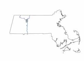
South Deerfield, MA
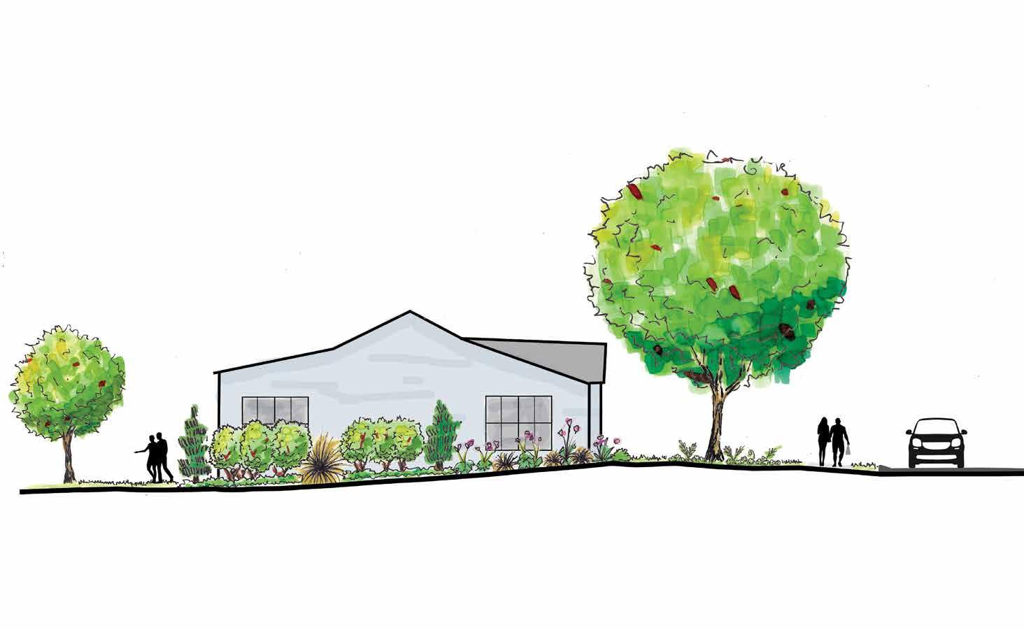
The Conway School Spring 2025
Santiago Fernandez Barrera and Sarah Brazil
The Conway School Spring 2025
Sugarloaf Condominiums is a 55+ community operating through a Homeowners Association (HOA). All outdoor maintenance is contracted-out, managed by the HOA, and paid for by residents’ monthly dues. Six residents joined together to create the Landscape Committee to represent the HOA in working with the students from the Conway School on a comprehensive landscape design. The primary goals outlined by the core team are to:
1. Phase out turfgrass by increasing native plants
2. Improve soil conditions
3. Create more shade
4. Create more privacy and visual interest
5. Create sample landscape designs the HOA can adopt as a standard for around homes
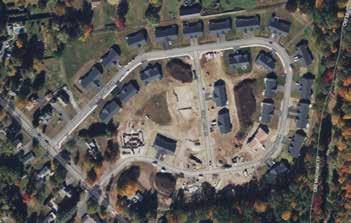
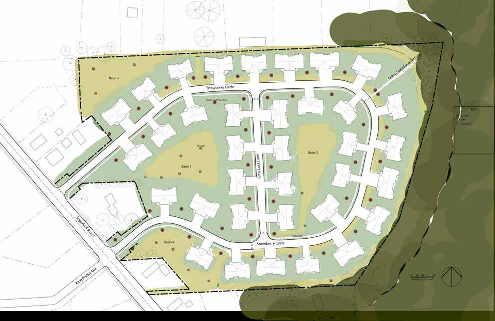
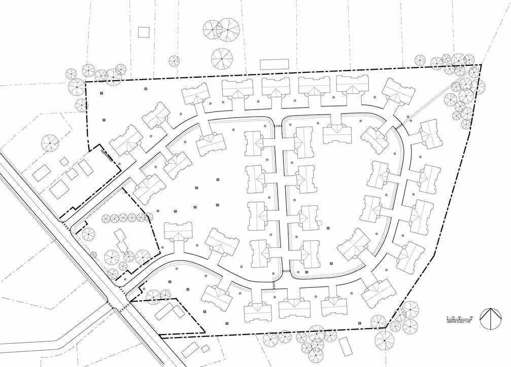
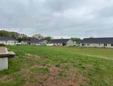
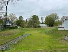
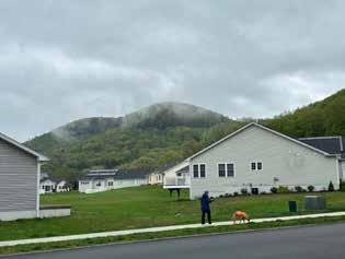
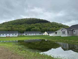
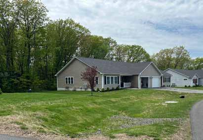
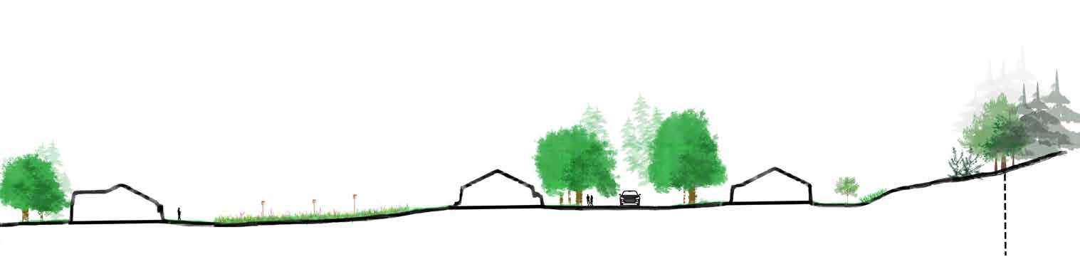
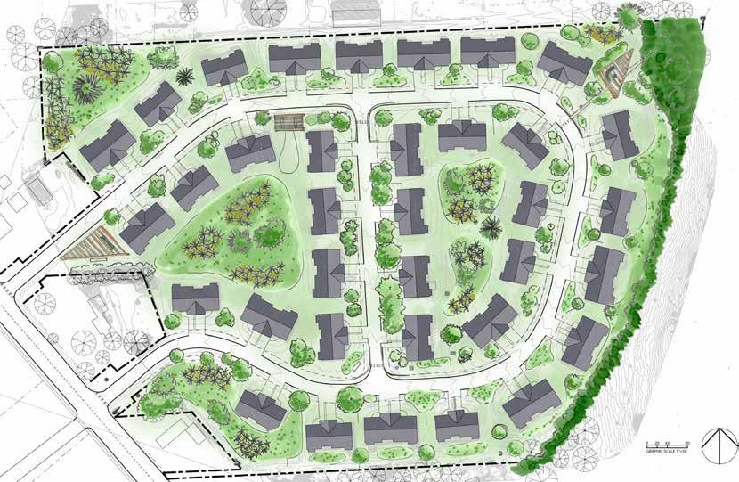
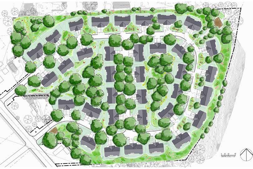
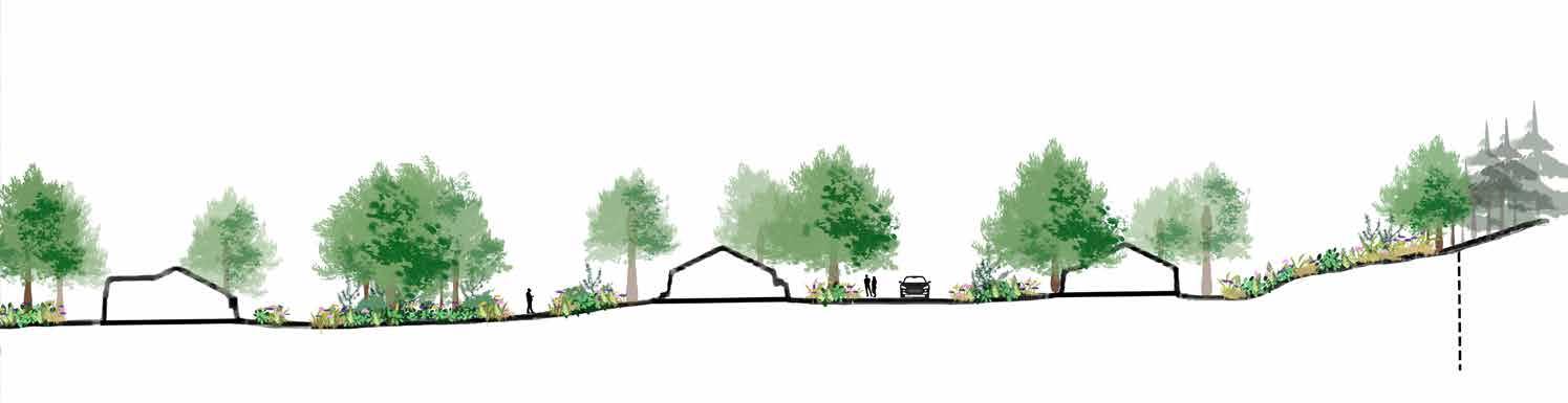
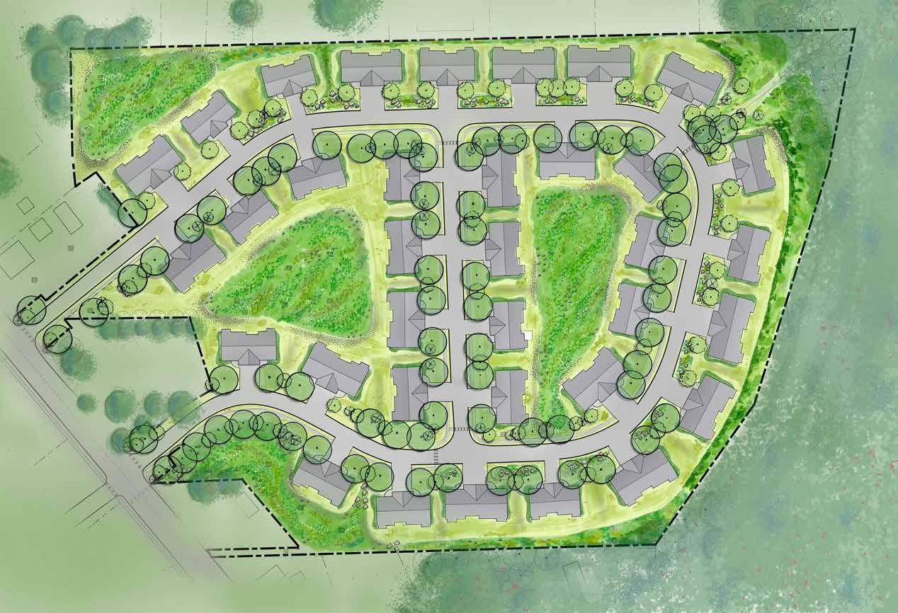
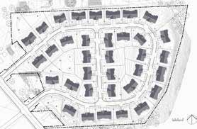
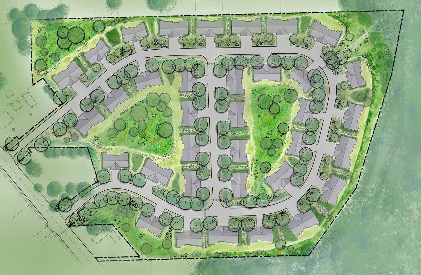
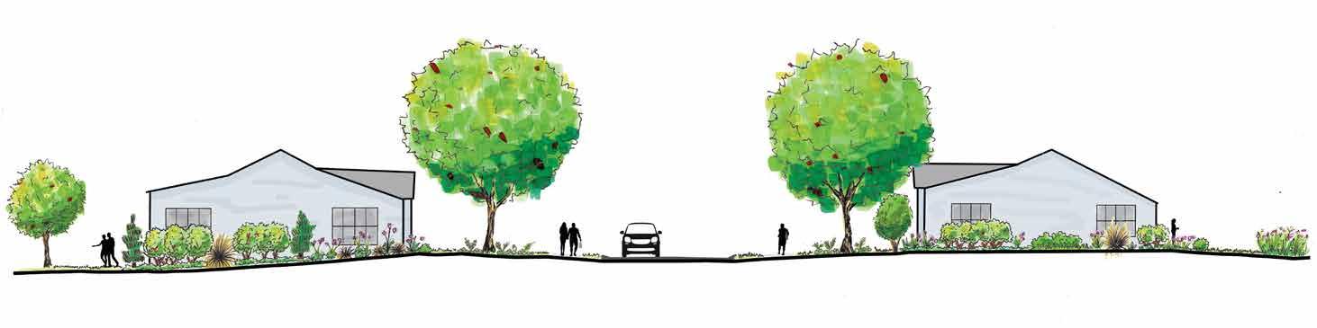
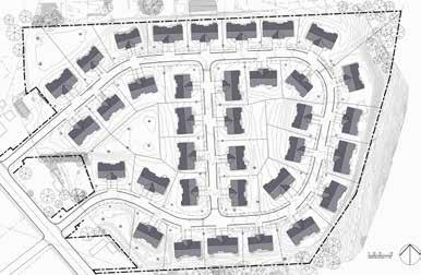
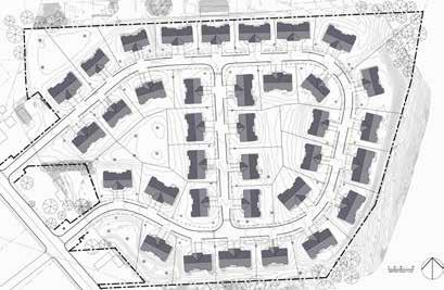
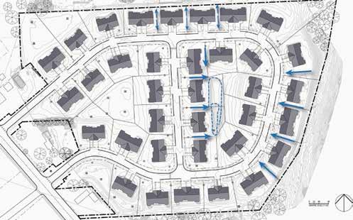
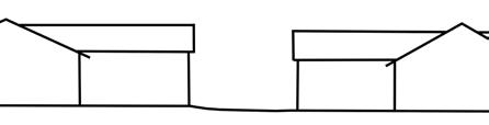
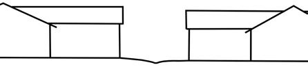
Sugarloaf Condominiums is a 22-acre development constructed between 2018 and 2022. There are 35 duplex houses layed out in a loop with a road that bisects it, creating two inner loops of houses. The houses are all on town water and sewer. There are open spaces behind the houses in the inner loops, at the southern entrance to the neighborhood, and behind the houses in the northwest corner. These open spaces contain dry-wells where water collects and infiltrates below the surface. Should the basins overflow, there are drains to city storm water infrastructure in the western and southwestern basins. The site is mostly lawn with red-leaf plum trees between each house. The neighborhood has trail access to Sugarloaf Reservation in the northeast corner which joins the trail that borders the neighborhood to the east.
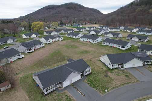
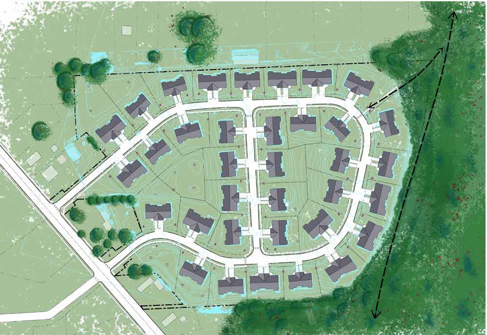
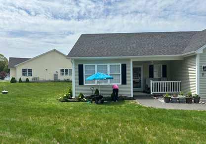
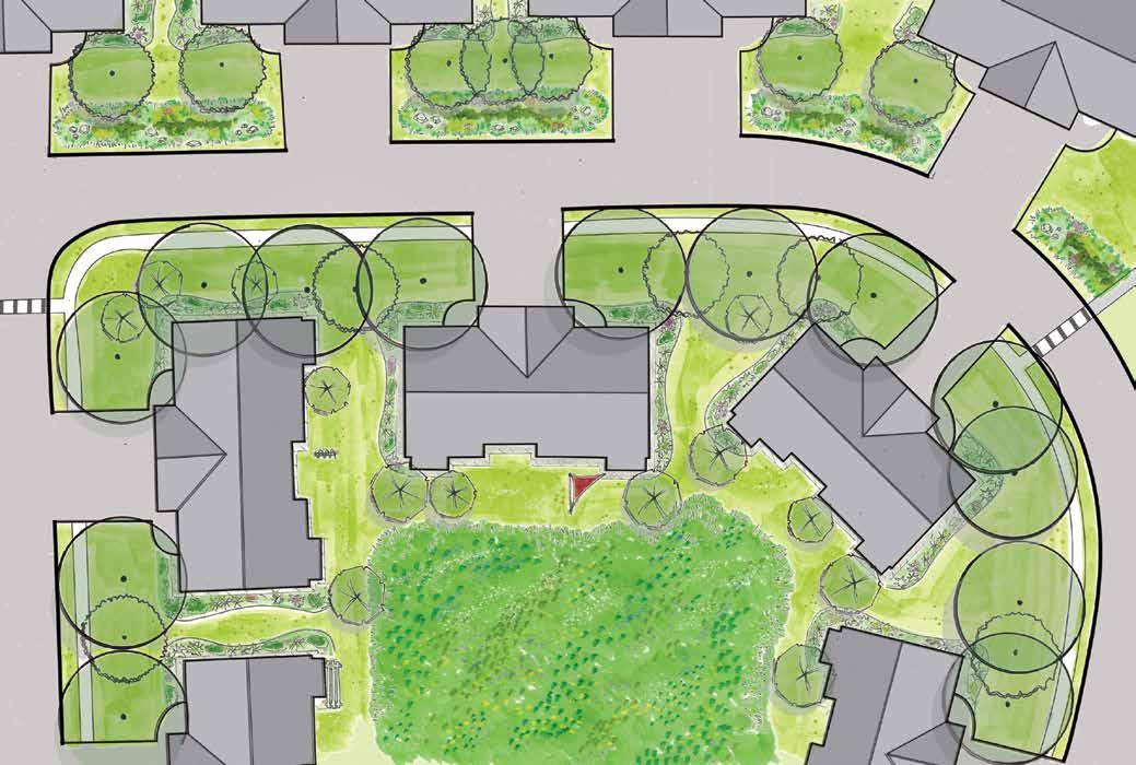
Homeowners technically own "up to the studs" of their unit. Each house has a three-foot-wide garden bed around the front, side, and/or back of the property. The HOA has standardized these beds to come with dwarf Alberta spruce trees which are maintained by the landscape company contracted by the HOA. Alternatively, homeowners may plant whatever they'd like in these beds, but they then take responsibility for the maintenance of this space. A small strip divides the driveways with sparsely growing vegetations. Homeowners have autonomy over these beds as well. The HOA owns and maintains the lawn, but homeowners are granted exclusive use of their respective lawn space.


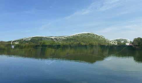
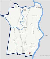
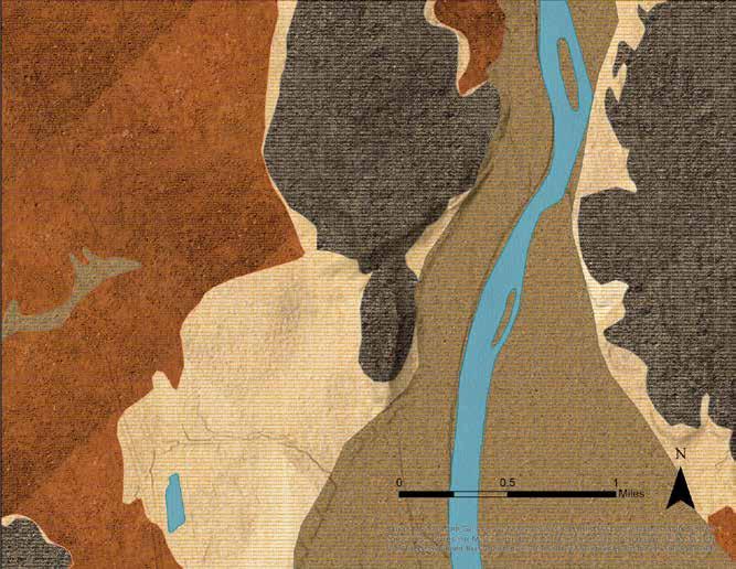
Geologists have identified the presence of a giant lake between 11,000 and 15,000 years ago stretching up the Connecticut River Valley to present-day Vermont. Known as Glacial Lake Hitchcock, it was formed during the de-glaciation period, and it was responsible for the formation of the rich alluvial soils in the area. It has had a lasting impact on the geology of the Connecticut River Valley, and in turn, the agriculture and human settlement in the area. The map above identifies Mount Sugarloaf, and the rest of the Pocumtuck Range, as one of the only stretches of land in the area above water during this time.
The Pocumtuck, early, Indigenous settlers of the area, tell a story that describes the Pocumtuck Range, or Pemawatchuwatunck ("the long, twisting mountains"), as the body of a giant beaver and Mount Sugarloaf, or Wequamps (the place where a hill drops off), as the head. The giant beaver, also known as Ktsi Amiskw, had formed an enormous pond that was taking over the land. The beaver was punished by the Creator and turned to stone. The pond drained, and the people were able to farm the land. The story is described in more detail in Cheryl Savageau's poem Ktsi Amiskw below. The story mixes Indigenous memory and ecological knowledge with climate and geologic history.
i. Ktsi Amiskw
In the big pond, Ktsi Amiskw, the Beaver is swimming. He has built a dam. The water in his pond grows deeper. He patrols the edges, chasing everyone away. This is all mine he says.
The people and animals grow thirsty.
Cut it out Creator says. And turns Ktsi Amiskw to stone. The pond is drained. There is water and food for everyone. See those hills, Ktsi Amiskw’s head, body and tail? He’s lying there still, this valley his empty pond.
Ii. Ktsi Amiskw Dreams
For living out of balance. Ktsi Amiskw lies still, while for centuries, his descendants are trapped in every stream, caught in every river, killed by the millions for fur-lust from across the sea. Their pelts buy blankets, cloth, weapons, knives.
In this world out of balance, Ktsi Amiskw dreams a hard dream: a world without beavers. Then, far away, like the promise of a winter dawn, he dreams the rivers back, young mothers building, secure in their skins, and a pond full of the slapping tails of children.
Cheryl Savageau
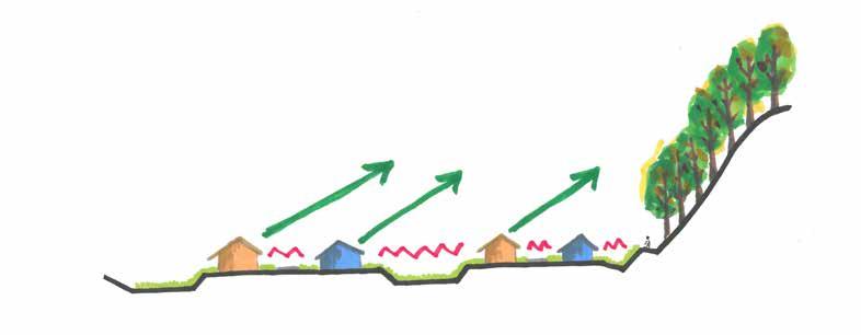
Much of the land in South Deerfield has historically been used for agriculture. Industrial-use is also common throughout the area. In recent history, agricultural land has been sold and developed for residential use. The shift is fairly common as the land is flat and already cleared of trees. This occurred for the development of Sugarloaf Condominiums. The implications are observed in the soil and vegetation composition.
After Glacial Lake Hitchcock's retreat, rich soils were left behind. These soils, which form the basis of agriculture in the Connecticut River Valley, consist of a diverse collection of rich soil types in the floodplains of the Deerfield and Connecticut Rivers. These prime agricultural soils have shaped the lives and cultures of Native American peoples for millennia and have been critical for the economic development of Deerfield in more recent history. Surficial geology maps provided by MassGIS show that the Sugarloaf Condominiums site sits between the sand and gravel deposits of the valley and the rockier till and bedrock of the Pocumtuck Range. Site soils were expected to be sandy, gravelly and with very little clay content and higher percentages of silt
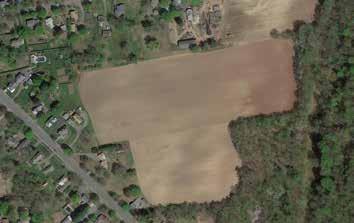
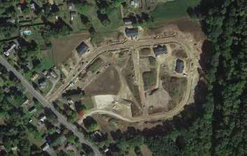
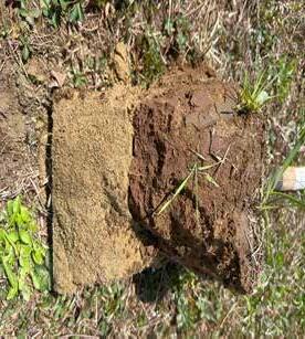
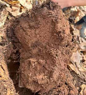
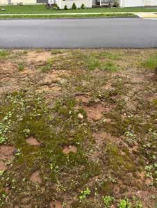
Prior to development, the site of was used primarily for growing corn and tobacco with several acres of forest abutting the Sugarloaf Reservation. Satellite images reveal that most of the forest was cleared and considerable earthworks was done during the development and construction process of the Sugarloaf Condominiums from 2019 through 2021 (see to the right). In spring 2025, holes dug on site showed that the soils on the site are compacted, particularly in the drainage basins where 8 to 10 inches of soil sit on top of what appears to be a sublayer of sand of uncertain origin. Soil was collected from an undisturbed area of the site for comparison. Samples were tested at UMass for nutrient levels and potential contamination. Jar tests were also conducted to determine the soil texture.
There are significant textural differences between areas with disturbed and undisturbed soil. Soil samples taken from the undisturbed area of the site contain higher percentages of organic matter, electrical conductivity (EC), and a lower pH. Texturally, the two types of soil also differ significantly. The undisturbed soil has a loam content of 31.1% and a negligible clay content of 2.2%, while the soil in the basins possessed equal amounts of silt and clay at 12.5% each. This textural difference may be attributed to the top soil being stripped during construction and new fill brought in. The soil compaction is likely due to the heavy machinery used during construction as well as the earthworks to create the retention basins. Additional compaction may be due to repeated use of landscape equipment over shallow-rooted plants.
The current soil conditions will require some decompaction and amending to grow native plants and trees.


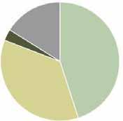
• Lawn makes up 45% of the site's surface cover.
• Its shallow root system has a depth of 1" to 4".
• It requires the most maintenance with fertilizer and herbicide application and weekly mowing.
• Wild urban plants (WUP) are spontaneous and adapted to thrive in areas of human development and disturbance.
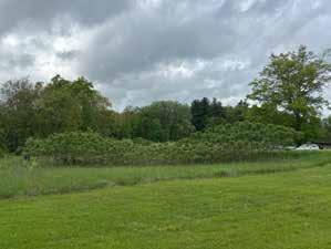
• They are mainly in the swales in front of houses and basins making up 36% of the site's surface cover.
• A few species include hairy bittercress, broadleaf plantain, yellow rocket, wild strawberry. These species colonize bare ground and are indicative of compacted and disturbed soils.
• These areas require weekly mowing.
• Northeast corner not cleared during development. Makes up 3% of the site's surface cover.
• No maintenance.
• Oaks, beeches, birches, and maples are a few species present. Around the House
• The 3-foot garden beds around houses contain dwarf Alberta spruce and mulch maintained by the HOA or plants of homeowners choice and their maintenance.
• The 1 to 3-foot strip dividing each driveway contains either bare soil, lawn, or is landscaped and maintained by residents.
• There are 44 Red-Leaf Plum trees that provide minimal shade. Many are in ill condition as the Prunus genus is susceptible to disease due to poor planting or damage during delivery.
• These make up small areas and therefore were not considered in the surface cover calculations.
The remaining 16% of the site's surface is covered with impervious materials such as asphalt, concrete, and houses where water is unable to infiltrate into the ground and runs-off the surface. 81% of the site's vegetation has high maintenance requirements with regular mowing (lawn and WUP). Due to compacted soil, minimal vegetation cover, and shallow root depth, the lawn and WUP act as semi-impervious surfaces. In rain events, water sheets off these areas and only infiltrates within the dry-wells in the basins. Considering this, 97% of the site's surfaces are impervious to water infiltration.


These wild, urban plants are highly evolved to live in conditions where frequent disturbance returns the species to an earlier stage of ecological succession. These species are symptoms of soil disturbance and degradation, and are capable of surviving in conditions other species are not capable of withstanding. There is a strong correlation between the location of the wild, urban plants and the locations of stormwater runoff in the swales and basins. This correlation reveals that the current stormwater management is moving water effectively, but also very quickly, and that is a source of disturbance. There is a positive feedback loop between the compacted soils with little organic matter, turfgrass with shallow roots that is mown frequently, and the erosion from fast-moving water. Each of these conditions support the continuation of the other conditions.
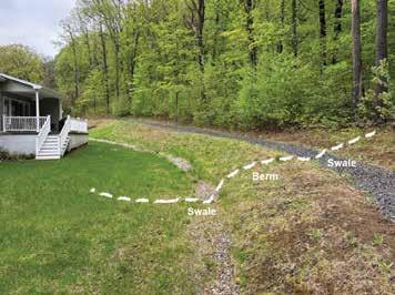
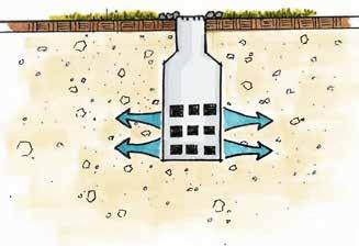
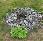
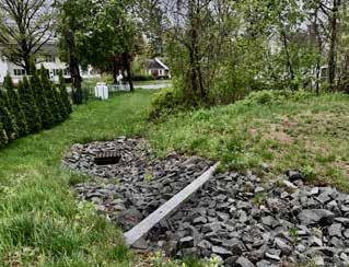
Drainage on site is controlled by heavy engineering and earthworks. Three large infiltration basins collect water near the northwestern and southwestern boundaries as well as between the houses in the western loop of the development. Each basin contains dry-wells where water infiltrates below the surface. Swales located in front of and behind the houses along the outer perimeter of the neighborhood direct water to the north- and southwestern basins. As part of this system, the swale along the eastern portion of the perimeter sits above a significant berm. The houses along the inner loops of the neighborhood all drain into the respective greenspace and/or basin behind each home. There are only curbs on the road where there are sidewalks: this includes the side of the road along the inner loop of the development as well as on both sides of Grey Lock Lane. The curbs direct most of the water off the road and into the swales in front of the houses along the outer loop. Some water does flow down the street and into a storm drain that flows into the dry-well system to infiltrate on site. There are two overflow drains for the western and southwestern basins where excess water enters the city sewer system. The stormwater system is currently functioning as designed where water infiltrates within 24 to 48 hours. Houses have gutters that drain directly into the yard or go underground and daylight farther from the house, such as in the swale in the front yard. Each unit has a full basement, and residents report that they have remained dry, with the exception of one house along the eastern perimeter.
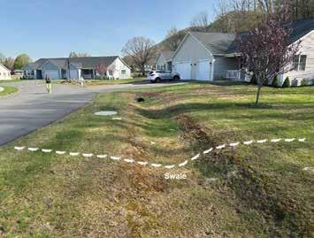
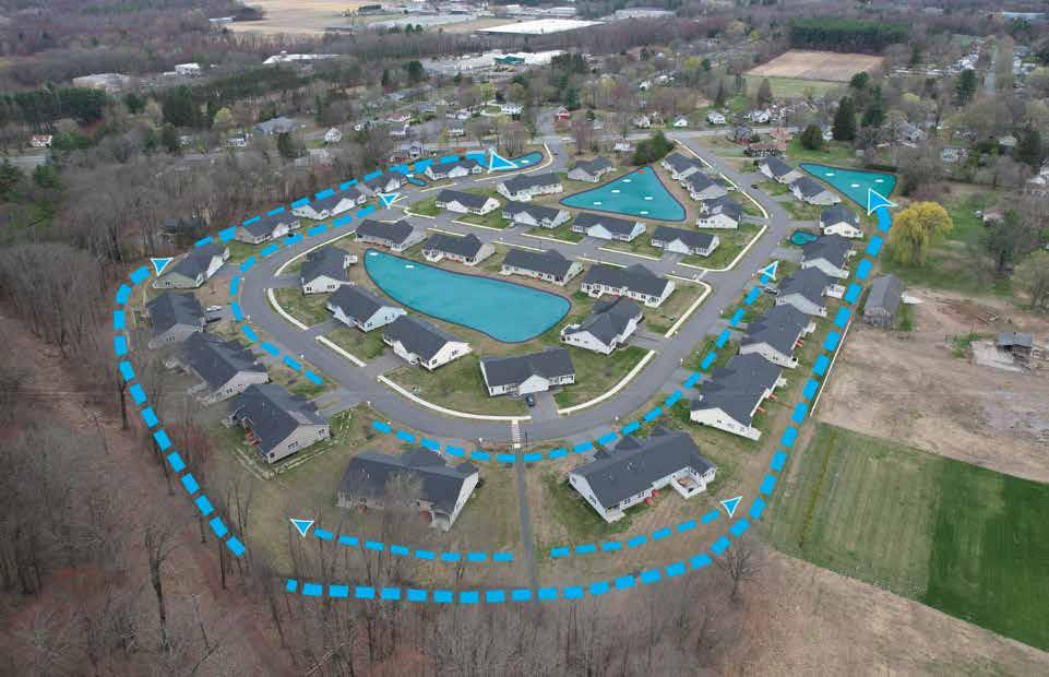
Infiltration tests conducted within the basins and greenspaces revealed that heavy soil compaction inhibits water from infiltrating in the basin soils except via the dry-wells. Water infiltrated at a rate of one inch per four hours in the compacted fill. Additionally, the current system moves water to these basins as fast as possible. These leaves very little opportunity for water to infiltrate elsewhere on the site. It also has led to erosion in many areas along the swales and basins where water is flowing quickly.
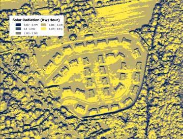
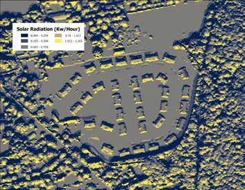
Early in the Conway team's conversations with the core group, they noted that the site would get extremely hot during summer. A core group member reported that during the hottest part of the year, she would use oven mitts to open the door to her porch because the doorknob would get so hot.
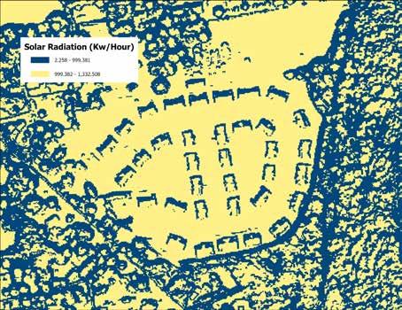
To determine how the construction of the development, the amount of impervious surfaces, and other factors affect the temperature on the site, the Conway team used an infrared digital thermometer to take temperature readings. Data was recorded on a mild, slightly overcast day with an air temperature of 73°F. Temperature readings on impervious surfaces such as asphalt and concrete were significantly higher than the daytime temperature, exceeding 105°F. Vegetated surfaces like the lawns were still quite hot, at around 89°F, while areas under shade, like the northeast corner of the property, were much cooler, with the lowest recorded temperature being 65°F. Other notable hot spots included southfacing surfaces in the basins and the south side of buildings. The center of the basins, where vegetation had been left a bit taller than the surrounding lawn, was significantly cooler than the recently mown lawn.
These temperature readings are consistent with the Urban Heat Island Effect (UHI), in which impervious surfaces tend to capture and radiate heat in urban and suburban areas, increasing the overall temperature. The effects of the Urban Heat Island Effect range from mild nuisance to potentially dangerous, as prolonged exposure to high temperatures can harm vulnerable groups of people, increasing the risk of heat stroke. Higher temperatures also increases ozone formation which can affect respiratory and cardiovascular health.
High temperatures also decrease the efficiency of Solar Panels and can increase the cost of cooling a home during hot weather.
Increasing the amount of shade on the site would help mitigate these negative health effects, significantly cool the site, and potentially decrease the use of air conditioning.


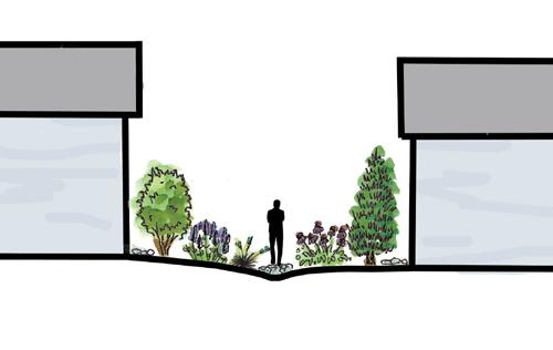
There are many exposed views between neighbors within the development and to neighboring properties. The houses along the eastern perimeter of the property are exposed to the trail along Mt. Sugarloaf where the treeline is thin with little vegetation. The houses that form circles around the drainage basins have unobstructed views from the backs of their homes where their porches and patios are located as they all face each other with no privacy. There are also unobstructed views from the roads within the development and from the road at the entrances to the development from Sugarloaf Street. Though porches and patios provide some sense of personal space outside, they have little privacy. Homes also have undesirable views of dying turfgrass and stormwater infrastructure.
However, there are striking views of North and South Sugarloaf Mountains as residents look north and east up the Pocumtuck Range. Places that look west and south do not feature these views. Additionally, these views are typically realized when looking up. They are not always visible from within the home. This results in unobstructed views that residents find unattractive when looking out of the homes, but lovely views when looking up either outside or from a north- or east-facing window.

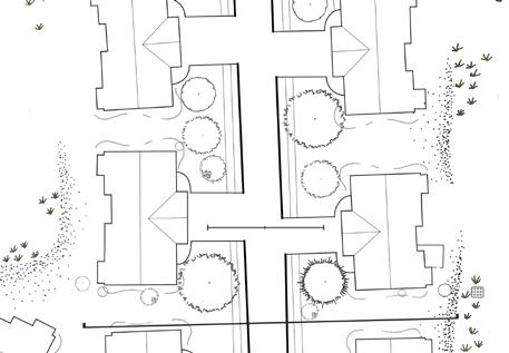
The site utilities are primarily grouped in an underground loop around the development from one end of Snowberry Circle to the other, with an additional line extending from the northern side of Snowberry Circle down Greylock Lane. Electrical supply, streetlights, and internet (Comcast) all run along the same underground channel. Their grouping makes it easy to map out and avoid while planting trees or laying out garden beds. Internet and electrical connection to individual units are also underground, these are not shown on the map.
All of the water in the development stays on the site, including street runoff. The stormwater system on site is connected to the dry wells. The inner part of Snowberry Circle and all of Greylock Lane have curbs to help channel stormwater into the catch basins, where it then passes through an oil-water separator before making its way into the dry wells and infiltrating into the ground. Rainwater that falls on unit roofs is channeled through gutters and downspouts. Some downspouts empty into swales or flow on the lawn, where water eventually makes its way to the retention basins and dry wells. Overflow systems exist on the western side of the central retention basin with a drop inlet and overflow channel. An overflow channel and drop inlet on the south side runs between two abutting properties in the southern basin.
The sewer on site is separate from the stormwater system. It runs beneath the middle of Snowberry Circle and is connected to the sewer running along Sugarloaf Street. The sewer system also runs down the middle of Greylock Lane and is connected on the southern side of Snowberry Circle. Sewer laterals connect from buildings to the mains bellow the street, though their locations are not noted on the map on the right.
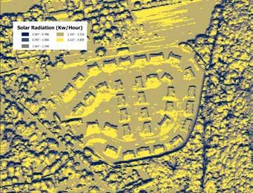
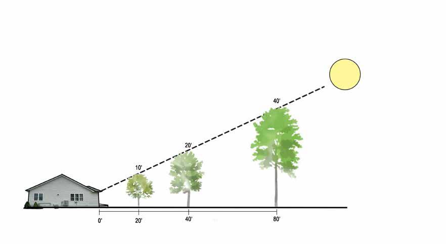
Ten units currently have solar panels installed, but due to the site's sun exposure, most units could have solar panels (see Sun Shade Analysis). Tree placement on the site will require careful planning to avoid shading existing and future solar panels.
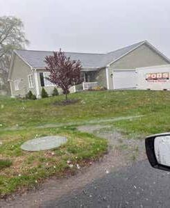
There is one underground storage tank (UST) for natural gas per every two to four units on the site. MassDEP recommends that trees and shrubs be planted at a minimum of ten feet away from tanks and that the area be accessible for maintenance. Additional regulations may apply and should be considered before planting. Location of pipes connecting UST's with houses are unknown and should be verified before planting.
The easement on the development is 40 feet on each side of the centerline of the street, as agreed upon by the developer and the condominium with Eversource Energy. Existing purple leaf plum trees are planted at the border of the easement. Per the agreement:
“...The Grantor agrees, except with written permission of the Grantee, that (1) no building, structure, or other improvement or obstruction shall be located upon; there shall be no excavation, filling, flooding or grading of; and there shall be no planting of trees or shrubbery upon the easement area…”
Planting within the easement will require careful planning and permits to avoid utilities and other underground structures.
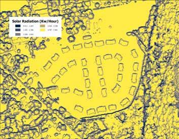
There are currently 10 units with solar panels on their roofs. However, due to the lack of canopy cover, most roofs in the neighborhood are suitable for solar in some capacity. Tree height, distance from solar panels, and growth rate all affect the amount of electricity PV panels can generate. Alternatively, the cooling effects that trees have on homes, through shade and evapotranspiration, help cool buildings and landscapes, reducing energy consumption in warmer seasons.
Baby Steps features a meadow mix in the open spaces behind homes and in infiltration basins. Bird boxes in the meadows provide additional bird habitat and a focal point in the meadow. Lawn alternatives better suited for the sites dry sandy conditions replace turf grass in the remaining areas around homes and sidewalks. Trees planted along sidewalks provide shade to pedestrians, and benches are located around the sidewalk loop for residents to sit and rest. Grasses and wildflowers in swales slow down water flow and assist in infiltration. This design requires the least amount of intervention, provides improved ecological benefit to the development, and creates some variety and shade for residents.
Benefits
• Increased infiltration
• Increased shade along streets
• Bird and pollinator habitat Challenges
• Still requires regular mowing
• Still a lot of sun exposure
• Minimal privacy
• No shared social spaces
This design was inspired by the early successional ecosystems observed around South Deerfield and the Pioneer Valley. This design seeks to minimize the amount of lawn in the development by emulating how old agricultural fields in the area transition from cultivation back into forests. The basins would be planted with a mix of wildflowers and grasses as well as early successional woody species such as staghorn sumac (Rhus typhina) and poplar (Populus sp). Woody species could be cut back and coppiced on a 2-3 year interval to maintain the early successional ecosystem, or allowed to continue growing. Understory trees would also be planted near the eastern edge of the development. Two shaded seating areas under a shade structure are shown, one near the northwestern intersection of Snowberry Circle and Sugarloaf Street and another by the pedestrian path leading to the trails on Mt. Sugarloaf. This design also proposes landscaping the swales with boulders and plants to slow down the stormwater and increase the visual appeal of these stormwater features. Early succession requires a medium amount of intervention but a more nuanced management approach that operates on a longer maintenance cycle as woody plants in the meadows will need to be coppiced on a two to three year cycle. Because mowing will happen more infrequently, invasive species will need to be monitored so they don't take hold.
Benefits
• Increased habitat diversity
• More visual interest and privacy
• Shaded seating areas
• Increased temperature regulation Challenges
• Woody plants in meadows require active management
• Maintenance required for shade sitting areas
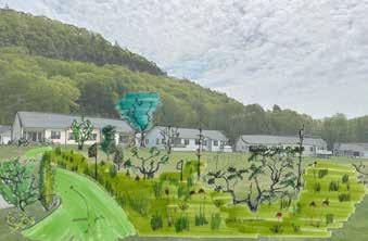
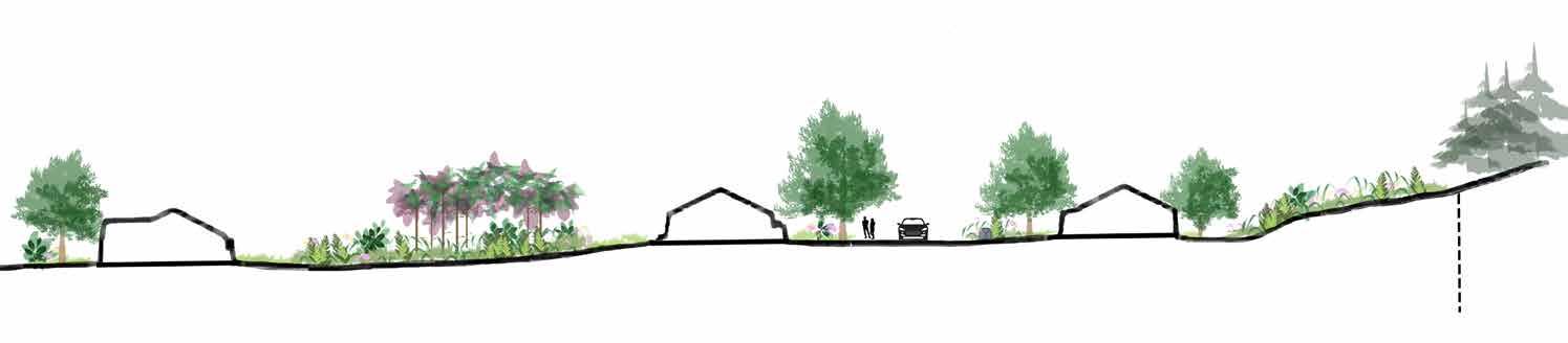
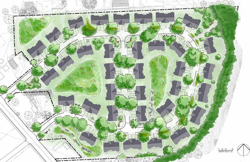
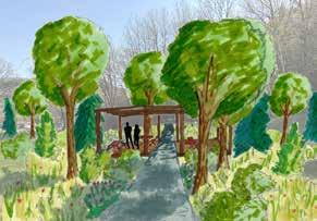
Sugarloaf Sandplains draws plant palette inspiration from the analogous ecosystem of the neighboring sandy Montague Plains. This design minimizes lawn, expanding rain gardens from the street up towards the house to slow down water flow, allow for infiltration, and create privacy and variety. Trees and shrubs shade the sidewalk and provide similar privacy and variety to homes along the inner loops of the development. The basins are activated with mown paths that allow residents to walk through shaded Scrub-Oak and Pitch Pine ecosystems. Additionally, this design features formal gathering spaces such as a pergola along the trail to Mt. Sugarloaf, an elevated deck along the southwestern basin, a landscaped seating area near the northern entrance to the neighborhood, and a mown area within the western basin. This design requires the most amount of intervention of the conceptual designs, provides the most ecological benefit, and creates the most privacy, variety, shade, and communal space for residents.
Benefits
• Most possible infiltration
• Most possible shade & privacy
• Shared social spaces
• Wildlife habitat Challenges
• Requires the most planting
• More maintenance during establishment
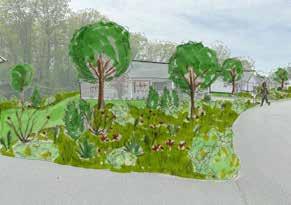
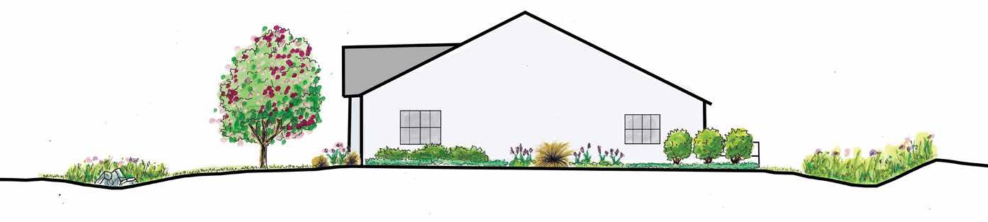
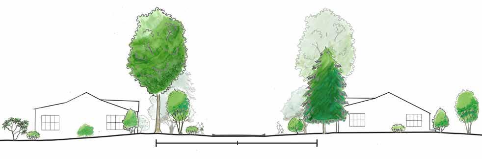
Large, canopy trees and flowering trees line the streets creating shade for pedestrians, increased privacy in front of homes, and a more welcoming environment when entering the neighborhood. Benches are added to the street corners of Snowberry Circle and Grey Lock Lane as well as along the trail leading to Sugarloaf to allow residents to rest in the shade as they walk. The open spaces behind homes and in infiltration basins are established meadows that create visual interest and provide habitat for birds and pollinators. Swales in front of and behind houses on the outer loop of the development are vegetated with grasses and wildflowers to help slow water down and allow for increased infiltration. The berm along the eastern portion of the development and the area along the trail leading to Mt. Sugarloaf are planted with wildflowers, grasses, and ferns to stabilize the bank, increase privacy, and increase water infiltration. The areas directly surrounding houses and leading up to the sidewalk or swale are switched to a low-growing lawn alternative such as clover or fleabane. This allows for ease of access and a tidy appearance while lowering maintenance inputs.
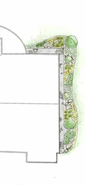
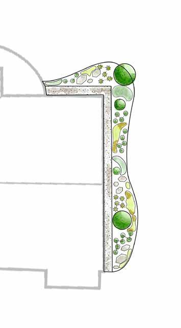
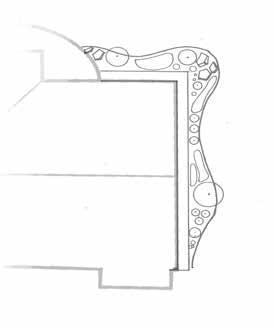
The existing 3-foot-wide garden beds along the foundation of houses are expanded to create a 3-foot stone drip line and 3 to 6-feet of garden space beyond that creating curved edges. The curves create a feeling of movement and soften the straight lines of the houses. The extent of the beds can be determined by the layout of each unit e.g. whether they have a sun room, porch, or fenced in patio. The garden beds can be planted with options from the palette provided depending on the needs of each unit, e.g. for privacy, preserving good views, seasonal interest. Residents can also opt to plant understory trees from the palette behind their unit for shade and privacy. Arbors, trellises, and shade sails create more comfortable spaces behind homes while increasing privacy between neighbors. These options allows for variety within the standardization of these areas.
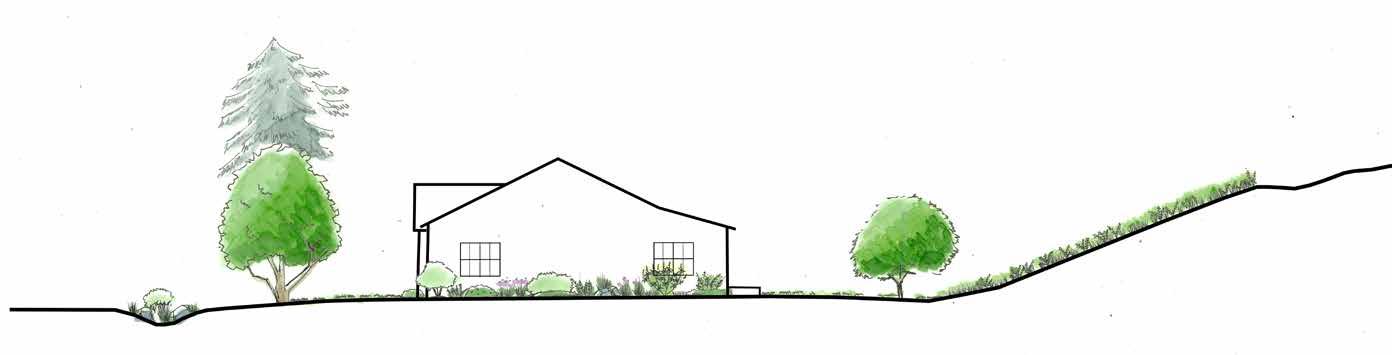
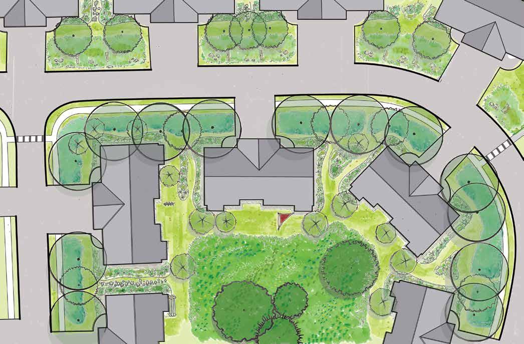
This design builds upon the Sugarloaf Meadows design to further increase privacy and shade and decrease lawn. Islands of trees and shrubs are established within the meadows to break up sightlines and provide privacy. They also create shade and further cool down the open space behind homes. Low-maintenance perennial, grass, and fern beds are established under street trees, further reducing lawn and creating more visual interest and pollinator habitat. Foundation beds between homes are pulled closer together and divided with a stone path, doubling as a dry-creek swale. Island beds are placed between homes that are farther apart. Checkdams and further landscaping are added to vegetated swales in front of homes to increase infiltration. A picnic table and benches are added to the open space just east of the north entrance to the development, creating an outdoor space for neighbors to meet, socialize, or simply enjoy alone.
Foundation beds between homes are pulled together and divided with a stone path that functions as a dry-creek swale. Island beds of perennials and shrubs are located between homes that are farther apart for privacy and water infiltration. Lowmaintenance groundcover beds are established underneath street trees. Strips of low-growing lawn alternative are along the sidewalk and around homes for access and a tidy appearance. Check-dams are added to the vegetated swales in front of homes along the outer loop of the neighborhood to further slow down water and allow for infiltration. Additional trees and shrubs can be added to these swales to give them a more landscaped appearance and expand the beds up towards the house, further decreasing lawn.
The design of the borders around each unit will vary significantly depending on the specific sun exposure and orientation of the area being planted. The samples below highlight particular design elements that can be used to create new HOA design parameters. The goal is to allow for a unique planting design for each unit that expresses the owner's taste, while still adhering to a standard that promotes a cohesive neighborhood design.
*Check spacing to ensure tree does not brush up against house at maturity
False Indigo
Three leaved Stonecrop
Lambs Ear
Boulders accentuate plantings and provide contrast
Flowering Tree in the corner for seasonal interest*
Grasses or Sedges add texture and movement
Tall perennials in the back
Groundcovers towards the front
Shrubs can add privacy to windows
Brown Fox Sedge
Beach Plum
The house border palette can be customized based on plant availability. Homeowners can select one or two plants from each category, depending on the bed's sun exposure, allowing them to create a suitable plant combination for their home's surroundings. Seasonal color can be added with annual border plants or spring bulbs.
Lambs Ear
Sweet Fern
Beardstongue
Smooth Aster
three leaved Stonecrop
Field Stones
Brown Fox Sedge
Bottle Brush Buckeye
False Indigo
Field Stones
3 foot wide Drip Edge with washed river stones
3 to 6 foot wide curved border for interest and ease of maintenance
Drip Edge to keep water away from foundation
Slight changes in Curves and placement can make every unit design unique.
staying within the 3 to 6 foot width parameter and 3 foot wide drip edge will keep the design Cohesive
Small Tree Cercis canadensis redbud Chionanthus virginicus fringe tree
Small Tree Amelanchier arborea serviceberry Magnolia virginiana sweet bay magnolia
Shrub Aronia arbutifolia red chokecherry Cornus sericea red osier dogwood
Shrub Aesculus parviflora bottlebrush buckeye Comptonia peregrina sweet fern
Shrub Ilex glabra inkberry Rhus aromatica fragrant sumac
Perennial Polystichum aristochroides Christmas fern Baptisia australis false indigo
Perennial Carex vulpinoidea brown fox sedge Aster laevis 'Blue Bird' bluebird smooth aster
Perennial Heuchera americana coral bells Echinacea pallida purple coneflower
Perennial Tiarella cordifolia foam flower Hypericum sp St. John's wort
Perennial Polygonatum hybridum Solomon's seal Sisyrinchium angustifolium blue-eyed grass
Perennial Osmunda cinnamomea cinnamon fern Penstemon digitalis beardstongue
Ground Cover Asarum americanum wild ginger Stachys byzantina lambs ear
Ground Cover Chrysogonum virginianum green-and-gold Thymus sp creeping thyme
Ground Cover Juniperus sp creeping juniper Andropogon glomeratus bushy bluestem
Ground Cover Packera aurea golden ragwort Sedum ternatum three leaved stonecrop
The tree palette has been selected to have a variety of tree heights and spreads to maximize both shade and beauty for the condominum. The species in this palette have been selected for their suitability to site conditions including sandy soils, compaction and sun exposure. Selecting specific sites for trees will have to take into account the utilities easement (see Utilities Analysis) as well as the mature height and spread of the tree.
These trees are the relatively slow growing giants that can reach heights between 40 to 70 feet (or more) and will provide the most shade in the long term. Due to their maximum potential size at maturity these require the most careful spacing. They should be placed outside the 40ft easement and at least 30 ft from buildings but some tree species might require more spacing.
• Growth patterns and shape should also be taken into consideration when spacing canopy trees.
• Phototropic dominant trees grow towards light and their main trunks can lean and should be placed further away from buildings or on the south side (e.g. American sycamore).
• Gravitropic dominant trees grow against gravity and tend to have straight trunks and can be placed closer to buildings and are a better choice for the northern side of buildings. (e.g. catalpa)
• Pruning trees for a strong central leader can direct its growth upwards to create a taller canopy and a more stable structure.
Smaller and faster growing than canopy trees, understory trees grow between 15 to 30 feet and are good candidates to be planted within the easement or closer to buildings provided there are no other obstructions.
• Many are also adapted to some shade from other trees or structures.
• Despite their smaller size they can also provide ample shade.
• Can be highly ornamental and many provide food for pollinators.
Shrubs are typically smaller than trees, and often characterized by their multi-stemmed and low-branching habit. Included in this selection are larger shrubs for screening where trees may not be appropriate, as well as smaller shrubs are good candidates to plant within the easement and closer to structures.
• Their denser form can be highly beneficial cover for birds and other wildlife
• Shrubs can shade ground reducing temperature.
• Can be massed to cover large areas.
• Provide privacy and structure in the landscape without being too large.
• Some shrubs respond well to pruning to maintain a more manicured size and shape.
Canopy Cladrastis kentukea American yellowwood Fabaceae 35-45ft 40-50ft Flowers, Shade May to June
Canopy Quercus velutina black oak Fagaceae 50-60ft 50-60ft Shade -
Canopy Quercus palustris pin oak Fagaceae 50-70ft 40-60ft Shade -
Canopy Gleditzia triacanthos honey locust Fabaceae 60-80ft 60-80ft Shade May to June
Canopy Catalpa speciosa northern catalpa Bignoniaceae 40-70ft 20-50ft Flowers,Shade May to June
Canopy Pinus rigida pitch pine Pinaceae 40-70ft 20-40ft Shade -
Canopy Platanus occidentalis american sycamore Platanaceae 75-100ft 75-100ft Shade April
Canopy Acer rubrum red maple Sapindaceae 40-70ft 30-50ft Shade, Fall March to April
Understory Amalanchier arborea shadbush Rosaceae 15-25ft 15-25ft Flowers, Fruit March to April
Understory Amalanchier laevis serviceberry Rosaceae 15-40ft 15-40ft Flowers, fruit March to April
Understory Cercis canadensis redbud Fabaceae 20-30 25-35ft Flowers, Fall Color April
Understory Betula populifolia gray birch Betulaceae 20-40ft 10-40ft Bark -
Understory Cornus florida flowering dogwood Cornaceae 15-30ft 15-30ft Flowers April to May
Understory Prunus maritima beach plum Rosaceae 8-12ft 3-6ft Flowers, Fruit April to May
Understory Rhus typhina sumac Anacardiaceae 15-15ft 20-30ft Fall Color June to July
Understory Magnolia virginiana sweetbay magnolia Magnoliaceae 10-35ft 10-35ft Flowers May to June
Understory Chionanthus virginicus fringe tree Oleaceae 12-20ft 12-20ft Flowers May to June
Shrub Ilex opaca inkberry Aquifoliaceae 5-10ft 5-8ft Berries, Flowers December to February
Shrub Myrica pensilvanica bayberry Myricaceae 5-10ft 5-10ft Berries, Scent -
Shrub Cornus seriaca red-osier dogwood Cornaceae 6-9ft 7-10ft Flowers, Bark May to June
Shrub Rhus aromatica fragrant sumac Anacardiaceae 2-6ft 6-10ft Fragrant April
Shrub Vaccinium sp blueberry Ericaceae 2-6ft 3-5ft Flowers, Fruit June to August
Shrub Comptonia peregrina sweetfern Myricaceae 2-5ft 4-8ft Fragrant April to May
Shrub Aesculus parvifolia bottlebrush buckeye Sapindaceae 8-12ft 8-12ft Flowers June to July
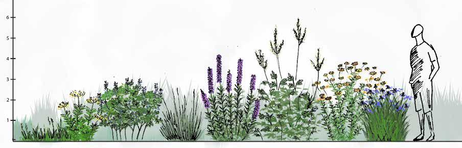
The plants in this palette have been selected to thrive the collection and retention basin areas that have sandy compacted soils and intermittent flooding. They are meant to be spread by seed mix or plugs to spread quickly and fill in the open areas in the condominium. Their composition will change over time as plants spread and mature that will add a nice dynamic change to the space from year to year. These plants are meant to be cutback once a year in the late winter early spring and should mostly get to a maximum of 8 feet.
• Succession of color and species through the growing season.
• Resource for pollinators in the spring and summer, seeds in the autumn for birds.
• Provide a nice backdrop to wildflowers.
• Fibrous roots are deep and help decompact soil and prevent erosion.
• Dense and cover large percentage of the ground.
• Provide cover and forage for birds, insects and small mammals.
• Roots have symbiotic relationship with nitrogen fixing bacteria.
• Some have deep tap roots that help to open the soil and decompact.
• Specialized roots feed soil bacteria and microorganisms, increasing biological activity in the soil.
• Increasing biological activity in the soil improves its ability to grow plants and support life.
• Small shrubs that can be coppiced or cut back hard, woody to semi woody.
• Provide cover for birds.
• Can add some structural and height variety to meadow.
Grass/Sedge/Rush Andropogon gerardii
Grass/Sedge/Rush Carex vulpinoidea
Grass/Sedge/Rush Eragrostis spectabilis purple love
Grass/Sedge/Rush Schizachyrium scoparium little bluestem Poaceae
Grass/Sedge/Rush Sorghastrum nutans indian grass Poaceae 48"+ Fall
Meadwo Shrub Ceanothus americanus New Jersey tea Rhamnaceae 36-48"
Meadow Shrub Chamaecrista fasciculata partridge pea Fabaceae 24-36"
Meadow Shrub Desmanthus illinoensis Illinois bundle blower Fabaceae 24-48"
Soil Builder Babtisia australis false indigo Fabaceae
Soil Builder Dalea purpurea purple prairie clover Fabaceae
Wildflower Anemone canadensis Canada anemone Ranunculaceae 12-18"
Wildflower Asclepias incarnata rose milkweed Apocynaceae 36-48" Late Summer
Wildflower Eupatorium maculatum joe pye weed Asteraceae 48"+ Late Summer
Wildflower Eupatorium perfoliatum boneset Asteraceae 36-48" Late Summer
Wildflower Gentiana andrewsii bottle gentian Gentanaceae 18-24" Late Summer
Wildflower Helenium autumnale sneezeweed Asteraceae 36-48" Late Summer
Wildflower Hibiscus laevis rose mallow Malvaceae 48"+ Early Summer
Wildflower Iris versicolor northern blue flag Iridaceae 24-36" Late Spring
Wildflower Liatris pycnostachya prairie blazing star Asteraceae 48" Early Summer
Wildflower Mimulus ringens monkey flower Plantaginaceae 18-24" Early Summer
Wildflower Monarda punctata spotted bee balm Lamiaceae 12-36" Late Summer
Wildflower Penstemon digitalis beardstongue Plantaginaceae 36-48" Early Summer
Wildflower Persicaria punctata smartweed Polygonaceae 18-24" Early Spring
Wildflower Phlox pilosa prairie phlox Polemoniaceae 12-24" Late Spring
Wildflower Physostegia virginiana obedient plant Lamiaceae 36-48" Early Summer
Wildflower Pycnanthemum virginianum mountain mint Lamiaceae 24-36" Early Summer
Wildflower Rudbeckia hirta black-eyed susan Asteraceae 24-36" Late Summer
Wildflower Thalictrum dasycarpum purple meadow rue Ranunculaceae 48"+ Early Summer
Wildflower Tradescantia ohiensis Ohio spiderwort Commelinaceae 24-36" Late Spring
Wildflower Veronicastrum virginicum Culver's root Plantaginaceae 48"+ Early Summer
Wildflower Zizia aurea Golden Alexanders Apiaceae 24-36" Late Spring
This limited plant palette contains species for stabilizing the steep berms and softening the woodland edge along the trail to Mt Sugarloaf. Softening the edge will create a smoother visual transition, increase valuable woodland edge habitat, and reduce lawn in this area of the property. Native perennials like ferns and sedges are recommended for the steepest areas and along the pathways while trees and shrubs should be spaced along the trail towards the road.
• This area will only need to be mowed yearly or on a two year cycle to prevent larger woody plant species on the steepest part of the berm from taking hold. This will help preserve the integrity of the berm.
• Perennials like blue-eyed grass, cinnamon fern, and Pennsylvania sedge will only grow between 1 to 2 feet tall and will spread laterally to fill the area.
• Shrubs like sweetfern, bayberry, and inkberry will add structural diversity and great cover for birds going between the woodlands on Mount Sugarloaf and the open spaces in the neighborhood.
• Native trees like dogwood, maple, and birch will pull some of the woodland species on Mount Sugarloaf into the neighborhood, expanding shade and increasing the appeal of the trail for homeowners.
Perennial Polygonatum hybridum Solomons seal Asparagaceae 3-5' Late spring
Perennial Sisyrinchium angustifolium blue-eyed grass Iridaceae 8-12" Late spring
Perennial Carex pensylvanica Pennsylvania sedge Cyperaceae 6-12" Spring
Perennial Onoclea sensibilis sensitive fern Onocleaceae 2-4'
Perennial Osmunda cinnamomea cinnamon fern Osmundaceae 2-5'
Shrub Rhus aromatica fragrant sumac Anacardiaceae 2-6' Early spring
Shrub Comptonia peregrina sweetfern Myricaceae 2-5' Spring
Shrub Ilex glabra inkberry Aquifoliaceae 5-8' Late spring
Shrub Myrica pensylvanica bayberry Myricaceae 5-10' Late spring
Shrub Vaccinium spp blueberry Ericaceae 1-8' Late spring
Shrub Corylus americana hazelnut Betulaceae 6-15' Spring
Shrub Betula populifolia gray birch Betulaceae 20-40' Spring
Tree Cercis canadensis redbud Fabaceae 20-30' Early spring
Tree Cornus florida flowering dogwood Cornaceae 15-30' Spring
Tree Acer rubrum red maple Sapindaceae 40-70' Early spring
Tree Acer saccharinum silver maple Sapindaceae 50-80' Early spring
This palette includes low-growing, creeping perennials that can withstand light to moderate foot-traffic. These species are cold-hardy and do not require regular mowing. Some of the species do require pruning or cutting-back annually. They can be established by over-seeding the existing lawn and observing which species are successful. As canopy trees mature, composition of future seeding may need to shift to more shade-tolerant species.
Rain gardens and swales present specific conditions that can be challenging for plants. Intermittent flooding and erosion from fast flowing water, can quickly be followed by dry-spells. They can also be a challenge to maintain in order to keep culverts clean. The plants in this palette were chosen to thrive in these challenging conditions.
• Densely and deeply rooted plants can improve water infiltration while resisting occasional strong rain events
• Ground covers can prevent erosion and spread quickly without adding too much bulk or height to the design
• Mixing carefully placed shrubs and fast growing perennials can fill the area quickly
• Dense plantings can slow down debris and allow it to be cleaned out before it clogs up culverts.
The map to the right identifies wetter and drier swales for the plants listed above. Generally, the swales between homes are drier, and the swales in front of and behind the homes along the outer loop are wetter. Species listed in green should do
in either location.
Maintaining organic land and soil practices is crucial for developing a healthy and sustainable soil ecosystem. Soil plays a vital role in supporting plant growth, storing water, and facilitating nutrient cycling. With growing concerns about the environmental impact of synthetic inputs, there is an urgent need to embrace organic land management techniques. As an added benefit, organic practices can be more economical and improve soil conditions like compaction, over time.
Some key soil management practices include:
• Reduce use of chemical fertilizers that kill beneficial microorganisms and disrupt nutrient cycling in the soil.
• Chemical fertilizers also negatively impact water quality when misused
• Organic amendments and natural fertilizers help to promote microbial activity and enhance soil fertility.
Mulching
• Covering the soil with mulch protects it from exposure to environmental conditions like heat, rain and wind.
• Mulch breaks down over time, returning essential nutrients to the soil and enriching its overall profile.
• Mulching retains moisture in the soil and prevents extreme temperature fluctuations in the soil
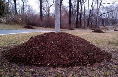
• Remove old mulch before applying new material to avoid build-up or "volcano mulching".
• High-traffic areas might need periodic decompaction or aeration
• Compacted soil can impede root development and decrease water infiltration, watch for standing water or bare spots in the landscape
A practical and sustainable strategy to prevent pests (insects, diseases, weeds and invasive plants) in the landscape is to employ Integrated Pest Management (IPM). IPM is a holistic approach that emphasizes prevention and minimal intervention in the landscape through common sense practices.
Prevention:
• Plant disease and pest resistant varieties.
• Practice proper pruning and planting techniques.
Monitoring:
• Observe the landscape regularly to catch issues early and prevent spread or damage.
• Understand and identify common invasive plants, insects, and diseases.
Identification
• Identify the organism to understand its lifecycle and develop strategies for control.
• Distinguish between pests and non-pests; this is often subjective.
• Some plants considered weeds can be tolerated in certain areas and situations.
• Aggressive plants like Japanese knotweed, oriental bittersweet and mugwort should be promptly removed to prevent their spread.
Action:
• Use pesticides sparingly as last line of defense.
• Implement spot treatments for a more targeted approach
• Rotate pesticide and herbicides types to avoid induced resistance
• Plant to attract invertebrate predators or provide nest boxes for birds
• Use microbial sprays like BT.
• Apply natural substances such as neem, horticultural soaps, and oils.
• Manually remove diseased or damaged plants.
• Set traps and barriers.
• Space plants appropriately and increase airflow by thinning.
• Remove dead or dying plants, especially if infected.
• Clear plant crowns and avoid mulch buildup around tree flares.
Practices
• Ideally, lawns and meadows should be mowed using a mulching mower. This practice returns organic matter to the soil, helping to improve lawn health.
Frequency
• Meadows should be mowed once per year during early spring
• Leaving vegetation standing over winter is beneficial, as it provides habitats for overwintering insects and other organisms and adds visual interest to the landscape.
Meadow Establishment
• Establishing a meadow can take several years; consider **mid-season mowing** if necessary. Always follow established protocols based on the specific type of seed mix used during the planting phase.
Mowing Height
• When mowing meadows, aim to cut to a height of about 5-6 inches to avoid damaging the crowns of perennial plants. This height supports healthy plant regrowth.
• Lawn should be mown to 3 inches about once a week during the growing season.
• Some material should be removed from meadows, particularly around dry wells to ensure they remain clear and functional.
Rain
• Regularly clear rain gardens and swales of debris, especially near culverts.
• Cut back foliage and clear overgrowth once per year.
• Assess culverts, dry-wells and other infrastructure regularly
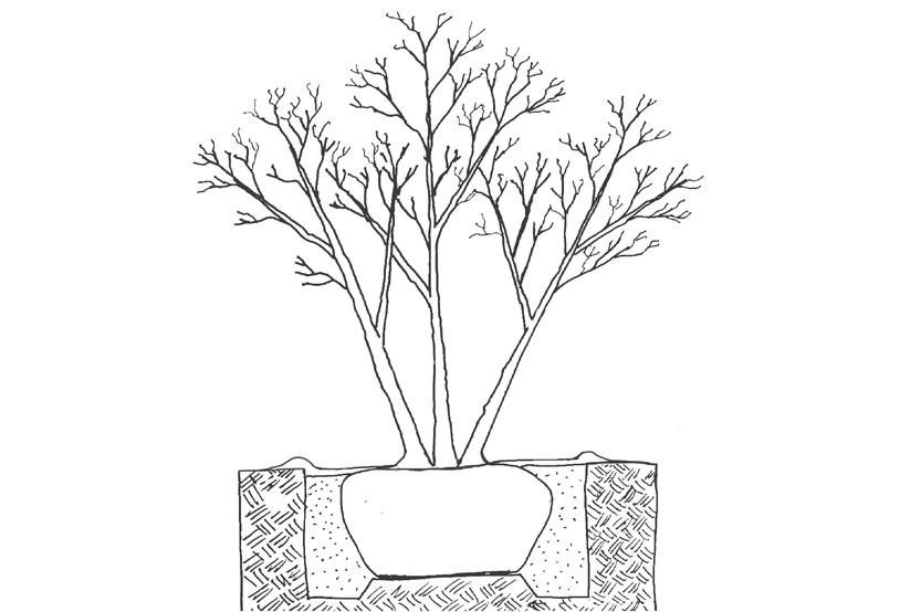
Proper planting techniques are essential for the establishment and long-term growth of trees. These are just a few things to look out for when planting trees out in the landscape:
• Plant at the correct height, ensure that the tree flair is exposed
• Completely remove all tree cages, burlap, and any other wrapping materials before planting.
• Assess roots before planting and prune any girdling roots.
• Backfill with native soil only.
• Fertilize towards the outer part of the root ball to encourage root growth into the surrounding soil
• Create a 4ft diameter circular bed around tree and mulch to a depth of 3 to 4 inches, ensuring it does not touch the tree flair
• Keep trees well-watered during the first couple of years, a small mulch berm can help with watering
The phasing below includes considerations related to installation of Sugarloaf Meadows (design one) through the implementation of Woodland Edge (design two). Grading must be done first, followed by soil decompaction, before vegetation is planted. Some of these projects below can be tackled simultaneously or in the order of residents' preference. Plantings around houses and on the eastern berm can be installed at any point once swales between homes have been excavated and soil has been decompacted. Several of these projects require further design and development, and consultation with the town, particularly those related to stormwater. There are also local specialists who can create detailed installation and maintenance plans for vegetated areas.
Grading
• Excavate swales between houses to assist in shedding water into the basins and swales in front of and behind houses.
• Deepen and widen the swale in the eastern dry-well basin in order to store more water and protect the houses along the western edge of that area from water intrusion.
Soil
• Mechanically decompact soil in large open areas with an excavator or tractor using the deep-ripping method.
• Add organic matter, topsoil, and/or compost tea
• Use a broadfork to manually decompact smaller areas.
Swales
• Following regrading and decompaction of the swales between homes, seed with groundcover.
• Following decompaction, add river rocks to the swales in front of and behind homes focusing on areas around the culverts and areas of heavy flow.
• Seed swales in front of and behind homes with appropriate meadow mix.
Trees
• Begin with planting canopy trees. This can be prioritized in specific areas such as the entrances to the neighborhood, street corners, and the trail to Mt. Sugarloaf. It could also be prioritized along sidewalks. Consider purchasing large caliper trees for higher-traffic areas (if species tolerate transplanting well) and smaller saplings elsewhere.
Meadows
• Following soil decompaction, hydroseed meadows with appropriate seed mix for soil and moisture conditions of each area.
• Weed-out undesirable species during establishment
• Add shade structures (trellises, arbors, and shade sails) to improve human comfort while trees mature Trees
• As time and funds allow, plant trees along outer loop of neighborhood.
• As canopy trees mature and conditions beneath become shadier, plant mid- and understory trees
• As funds allow and tree canopy matures, remove lawn (e.g. smother) and seed or plug with a low-growing groundcover alternative
Meadows
• Once established, mow meadows once per year, ideally in late fall or early spring.
• Monitor and weed as needed.
• As funds allow, add bench seating to street corners, the trail to Mt. Sugarloaf, and the open-space near the northern entrance to the neighborhood. In lieu of purchasing benches, consider accepting commemorative bench donations.
• Plant trees in meadows. These can be planted with shrubs to form islands within the meadows, or large trees can be planted alone to grow into a wide-spreading tree that stands out in the landscape.
• As canopy matures, continue to remove lawn and plant groundcover beds beneath.
• Landscape the swales between houses with river rocks and a more diverse palette of plants. In doing so, many of the foundation beds can be extended to meet. The rocks through the center function both as a maintenance path and for water direction and infiltration.
• Add check dams to swales in front of and behind houses along the outer loop of the neighborhood. These can be further landscaped with shrubs and ornamental trees
• Add picnic or cafe tables to the open space near the northern entrance to the neighborhood to create a communal space for residents to enjoy.
Meadows
• Continue to mow once per year.
• Overseed or interplant with desired species to supplement biodiversity. Add birdboxes.