Geology in Motion: The Effects of Warfare on Geology
1: Flooding
Tracks Award
From the Desk of the AER
The Sedimentology of High Perm Streaks and Reservoir Heterogeneity: Implications for CCS
The Blue View: Industry Trends Through Woodmac’s Lens
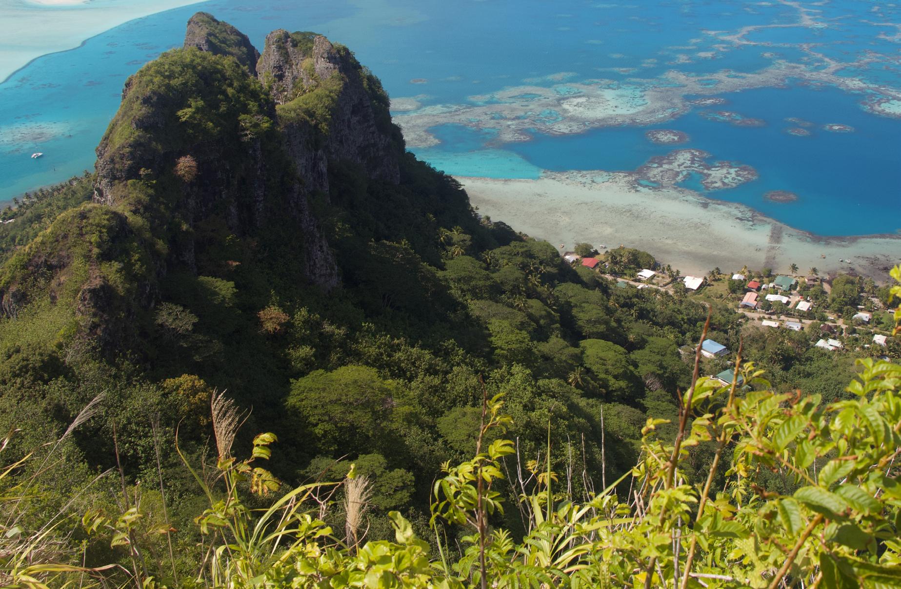
CLASSIC ATOLL, Polynesia.
Maupiti in the western Leeward Islands of French Polynesia is the oldest emergent volcanic island in a hot spot chain that includes Bora Bora, Moorea and Tahiti. The island trend reflects the motion of the Pacific plate northwestwards over the fixed Society hot spot. This southward view from Mt. Teurafaatiu summit (380 m) shows eroded flows of the volcanic shield (ca. 3.9-4.5 Ma) surrounded by a large lagoon with patch reefs. The coral reef barrier has a prominent tidal channel at its southern end. This configuration is consistent with the model first proposed by Charles Darwin in 1842 in which volcanic edifices develop a halo of carbonates that persists as a closed area even after the volcano has subsided below sea level or has been eroded away. Lagoonal sediments would be a mixture of volcanic debris and carbonate deposits.
Photo by: Jim Wood
PUBLICATIONS INFORMATION
The RESERVOIR is published 6 times per year by the Canadian Energy Geoscience Association. The purpose of the RESERVOIR is to publicize the Association’s many activities and to promote the geosciences. We look for both technical and non-technical material to publish.
The contents of this publication may not be reproduced either in part or in full without the consent of the publisher.
No official endorsement or sponsorship by the CEGA is implied
for any advertisement, insert, or article that appears in the RESERVOIR unless otherwise noted. All submitted materials are reviewed by the editor. We reserve the right to edit all submissions, including letters to the Editor. Submissions must include your name, address, and membership number (if applicable). The material contained in this publication is intended for informational use only.
While reasonable care has been taken, authors and the CEGA make no guarantees that any of the equations, schematics, or
devices discussed will perform as expected or that they will give the desired results. Some information contained herein may be inaccurate or may vary from standard measurements. The CEGA expressly disclaims any and all liability for the acts, omissions, or conduct of any third-party user of information contained in this publication. Under no circumstances shall the CEGA and its officers, directors, employees, and agents be liable for any injury, loss, damage, or expense arising in any manner whatsoever from the acts, omissions, or conduct of any third-party user.
Scott Norlin Wood Mackenzie directorfinance@cegageos.ca Linkedin
DIRECTOR
Marcelina Labaj
Central European Petroleum Ltd. fieldtrips@cegageos.ca Linkedin
DIRECTOR
Kevin Webb
Aquitaine Energy Ltd. conferences@cegageos.ca Linkedin
CONFERENCE INQUIRIES
Kristy Casebeer
Tel: 403-513-1234
Email: kristy.casebeer@cegageos.ca
MANAGING DIRECTOR
Emma MacPherson
Tel: 403-513-1235
Email: emma.macpherson@cegageos.ca
Geology in Motion: The Effects of Warfare on Geology
PART 2 FLOODING
SEAN FLETCHER, HAN BYUL WOO, DALLIN LAYCOCK, ERIN PEMBERTON, PAUL BREMNER, RICHARD MACKENZIE
INTRODUCTION
Local and regional geology has influenced military conflict and operations for millennia. Military strategists often pursue the high ground, and seek to use the terrain to their advantage. Drilling effective water wells and finding suitable building materials are also key components of leveraging geology for military purposes. In addition, many wars have been fought over geologic resources such as fuel, precious metals, and even the land itself. For this series of articles we are focusing on the effects of warfare on the terrain itself. Previously we looked at the scars of bombing left on the landscape, and now we look at examples of strategic flooding. These floods might not preserve an obvious mark on the rock record into the future, but these were catastrophic geologic events that were made possible by the geologic features of the battleground, and were life altering (or life ending) for the locals who were caught in the floods’ path.
EXAMPLE 1
1938 Yellow River Flood: Military tactics throughout history have commonly relied on the geography of the surroundings, with many battles determined by the topography. Only occasionally, however, have military strategies involved using the area’s geography itself as a weapon, altering the landscape in the process. One such tactic involves flooding rivers to impede operations of the enemy force. Perhaps the most daring, dangerous, and extensive fluvial disruption was the 1938 Yellow River flood in China. This event stands as a stark example of the extensive impact warfare can have on a river system. During the Second Sino-Japanese War, the Nationalist Government of China made the strategic
decision to breach the Yellow River's dikes at Huayuankou in June 1938. This deliberate act was aimed at halting the Japanese advance by creating a defensive barrier, but it also resulted in significant alterations to the landscape. In addition, it also proved deadly to over 500,000 people through drowning and subsequent disease and famine (Lary, 2001).
The Eastern Henan Plain in the lower reaches of the Yellow River has traditionally been prone to flooding and avulsions, prompting the building of levees during the Qing Dynasty (1645-1855) (Zheng et al., 2017, Zue, 1993). In 1855 the river underwent a natural avulsion, diverting to the course shown in Figure 1 (Pai, 2023). This course was then maintained until June 9, 1938, when the Nationalist Army destroyed the Yellow River’s south
embankment at Huayuankou in order to impede the progress of the Japanese army.
The immediate consequence of the dike destruction was the inundation of an extensive area across the provinces of Henan, Anhui, and Jiangsu. The flood zone varied in width, but was occasionally as wide as 80 km, and spanned approximately 400 km in length (Figure 1). Around 60% of the villages located in the eastern plains of the Henan province were flooded. Sediment deposition in some areas exceeded 5m in thickness (Pai, 2023). As the Yellow River poured into the valleys of the Jialu and Guo Rivers, it appears that the locals did not have any indications of the incoming flood, and had no time for early evacuation.
FIGURE 1: Map of the Yellow River’s current path, the flooded region from 1938-1947, and historical paths. Adapted from Xue, 1993, and Muscolino, 2015.
FIGURE 2: Map of Walcheren Island, depicting the flooding as of October 31, 1944, after the dike breaches were completed. Adapted from canadiansoldiers.com (refer to references and suggested readings).
The knock-on effects of the breach in the levee and subsequent flood were severe and longlasting. Erosion widened the initial breach from around 100m to approximately 1460m by 1946. Flooding caused significant changes to the hydrologic system, soil composition, and accessibility of farmland, leading to famine among the flood’s refugees. Extensive deposition of sediment from the floods contributed to substantial growth of reeds and subsequent breeding of locusts, affecting an area of over 900 km2, which further exacerbated the famine (Pai, 2023). The flood lasted nearly nine years until the restoration work was completed in 1947, artificially restoring the course back to the pre-1938 path. If not for this restorative engineering, the Yellow River would likely still be following this course in the present day.
EXAMPLE 2
The Battle of the Scheldt Estuary - Flooding of Walcheren Island
By September 1944, 5 years into WWII, the Allies recognised the port of Antwerp as being necessary for shortening their logistic lines inland. The German Armed Forces used longrange coastal batteries at Walcheren Island at the headwaters of the estuary to prevent allied ships from reaching Antwerp by sea or minesweeping the waters (Ellis, 1968).
Lieutenant-General Guy Simonds commanded The First Canadian Army and planned for the deliberate breaching of the dikes surrounding Walcheren using RAF Bomber Command aerial bombardments from 3-11 Oct 1944 (Copp, 2007). In the most simplistic description, the
FIGURE 3: Aerial picture of the breach in the sea dike at Westkapelle after the 3 October 1944 bombardment. Royal Air Force official photographer - http://media. iwm.org.uk/iwm/mediaLib//9/media9636/large.jpg This photograph C 4668 comes from the collections of the Imperial War Museums
dikes were reinforced dunes that surrounded the island, somewhat akin to an atol (Figure 2). The breaches resulted in the inundation of Walcheren lowgrounds with seawater, leading to significant geological changes, particularly in sedimentation of fields and erosion of the water channels at the breach sites. Seawater rushed in, carrying marine sediments that were deposited across the flooded areas. This sudden influx of marine sand and silt altered the soil composition, transforming fertile agricultural land into saline, futile ground. The new layer of marine sediment also changed the physical landscape that required extensive remediation efforts to regain its agricultural viability (Goodlet, 2013).
Walcheren's waterways were also dramatically changed. The broken dikes created new
paths for the seawater to flow, carving out new channels and widening existing ones. These changes rearranged the island’s fluvial landscape, including both temporary and permanent waterways. Rivers and streams, like the River Scheldt, were forced to change their courses, which impacted the local geography and required adjustments to water management strategies (Goodlet, 2013).
Towns and cities across the island faced unique challenges. Vlissingen's harbor was clogged with sediment that required extensive dredging for port operations. In Westkapelle, where the dikes were initially breached, new water channels and sediment deposits required major reconstruction efforts. The historic town of Veere faced similar issues with siltation in its harbor and waterways, disrupting its role as a local trade center. Middelburg, the capital of Zeeland, dealt with the indirect effects of altered water flow and sedimentation in surrounding agricultural lands, prompting necessary adjustments to local water management infrastructure (Goodlet, 2013).
The task of restoring Walcheren after the war was immense. Dredging was crucial to clear out the clogged channels and restore navigability and drainage (Goodlet, 2013). The saline soil needed to be treated to restore fertility to the land. Essential dikes were rebuilt to protect the island from future flooding. New water management practices were implemented to adapt to the altered water flow patterns and ensure effective drainage. These combined geologic and engineering efforts were vital to
return Walcheren back to its pre-war state and to secure its long-term sustainability.
EXAMPLE 3:
Dambusters Raid: Allied forces in WWII identified the dams of the Ruhr Valley in Germany as a strategic military target, as these dams were used to generate hydroelectric power and as a fresh water source for steelmaking. Anticipating this threat, the German Armed Forces installed nets to prevent torpedoes from reaching the dam. To evade the nets, the allies invented a barrelshaped bomb that they could drop from a modified Lancaster bomber aircraft. The bomb was designed to skip on the water over the nets, then strike the dam wall and sink to the bottom before exploding.
The Dambusters raid, officially named Operation Chastise, significantly changed the landscape of the Ruhr Valley. When the Möhne, Eder, and Sorpe dams were breached, a massive volume of water was suddenly released downstream, where almost 1300 people were killed from the flooding (Adamo et al., 2020). The powerful floodwaters swept away soil, rocks, and plants, causing extensive erosion along riverbanks and riverbeds that were deposited further downstream.
The heavy load of deposited sediment and debris changed sedimentation patterns and created new landforms like sandbars and silt deposits. These changes had a lasting impact on regional agriculture and infrastructure, where fertile farmland was buried under
FIGURE 4: Image of the Möhne Dam after the attack, showing the damage to the dam, as well as debris in the foreground. Image credit: By Bundesarchiv, Bild 101I-637-4192-20 / Schalber / CC-BY-SA 3.0, CC BY-SA 3.0 de, https://commons. wikimedia.org/w/index. php?curid=5413163.
sediment and transportation routes were disrupted.
In addition to the impact of erosion and deposition on landforms, the floodwaters altered the natural courses of rivers. The force of the water carved out new channels and widened existing ones, permanently changing the geomorphology of the river system. These new channels disrupted the existing flow patterns and created challenges for water management and flood control.
The floodwaters also inundated wide areas of the floodplain, creating temporary lakes and ponds. These water bodies gradually drained or evaporated, leaving behind layers of finegrained sediment. This further altered the local topography and contributed to the region's evolving landscape. The changes in water flow and sediment deposition also affected the region's ecology, disrupting biological habitats for fish and other aquatic organisms.
The destruction of infrastructure was another significant consequence of the floods. Bridges, roads, and buildings along the rivers were heavily damaged or destroyed, adding to the debris carried by the floodwaters. This debris further influenced the changes in the river systems, making the recovery effort even more challenging.
The Dambusters raid caused dramatic and long-lasting changes to the Ruhr Valley. The combination of erosion, deposition, and channel alteration reshaped the landscape in ways that were felt long after the immediate aftermath of the floods.
CONCLUSION:
Reclamation projects in the aftermath of these strategic floods limit the lasting geologic evidence of these events, but each of them highlights the powerful and far-reaching effects that human actions, even in war, can have on the natural environment. The combined effects of these battles have flooded plains, altered the course of rivers, deposited widespread sediment, and limited production of energy. In addition to the effects these floods have on the landscape, there is the additional human element to these battles. In the immediate aftermath of the 1938 Yellow River flood, between 38,000 and 89,000 civilians drowned. In the years that followed, it is estimated that up to 500,000 more civilians died from subsequent famine, disease, and drowning. Operation Chastise is estimated to have killed approximately 1300 civilians. Given these devastating effects to people and the environment, the Geneva Conventions were amended in 1977 to prevent attacks on dams and dikes. The next installment of this series will look at examples of how warfare has affected sedimentology.
REFERENCES AND SUGGESTED READINGS:
Adamo, Nasrat, et al. "Dam safety: hazards created by human failings and actions." Journal of Earth Sciences and Geotechnical Engineering 11.1 (2021): 65-107.
Copp, T. (2007). Cinderella Army: The Canadians In Northwest Europe, 1944-1945. Ellis, L. F. & Warhurst A. E. (1968). Victory in the West, (Vol. 2). London: Her Majesty’s Stationery Office.
Goodlet, K. W. (2013). "Reduced to the banks of mud from which they were reclaimed": The province of Zeeland, war and reconstruction, 1940-1945. Canadian Journal of Netherlandic Studies / Revue canadienne d'études néerlandaises, 34(2)
Lary, D. (2001). Drowned Earth: The Strategic Breaching of the Yellow River Dyke, 1938. War in History, 8(2), 191–207.
Muscolino, M. S. (2014). The Ecology of War in China: Henan Province, the Yellow River, and Beyond, 1938–1950. Cambridge: Cambridge University Press. Pai, P. (2023). Where military and fluvial geographies disastrously conjoined: The Huayuankou flood of 1938–1947 during the Sino-Japanese war. Journal of Historical Geography, V. 81. P. 146161.
Xue, C. (1993). Historical changes in the Yellow River delta, China. Marine Geology, V. 113. P. 321329
Zheng, S., Wu, B., Wang, K., Tan, G., Han, S., Thorne, C. (2017). Evolution of the Yellow River delta, China: Impacts of channel avulsion and progradation. International Journal of Sediment Research, V. 32. P. 34-44.
ROAD RACE
AND FUN RUN
Bow River Pathway 6:00 pm - 9:00 pm SEPTEMBER 26, 2024
ABOUT THE RACE
Sweat the Subsurface Road Race and Fun Run/Walk is an annual event that brings together participants from the geoscience community and beyond for a fun and competitive running experience. The CEGA/CALEP/CSEG collaborative event offers several race distances to accommodate participants of all skill levels, including a 5K and 10K.
SPONSORSHIP OPPORTUNITIES AVAILABLE
We're seeking sponsors for the Road Race and Fun Run/Walk! This is a fantastic opportunity to showcase your brand and connect with our community.
Click the button to register for this race, learn more about the tournament and sponsorship opportunities.
TRACKS AWARD
The Tracks Award is for Members Who have Set New Standards of Excellence
The Tracks Award is presented to CEGA members and friends of the CEGA to recognize specific meritorious service to the Society through committee or other volunteer work. The objective of this award is to recognize individuals who have set standards of volunteer excellence within the Society of whom we can follow, be proud and derive benefit. This award distinguishes members and friends who have excelled at a particular volunteer position by an exceptional committee function, initiating new and innovative ideas or making a significant effort that goes beyond that of the usual volunteer. The award is specific to a particular event or major contribution.
WENDY SHIER, M.SC., P.GEO.
Wendy is a seasoned professional with over 25 years of valuable experience in Canada's dynamic energy industry. Throughout her career, she has demonstrated a remarkable blend of technical expertise and leadership acumen, earning her a distinguished reputation within the sector.
Wendy is deeply passionate about mentoring and career development. Recognizing the importance of guiding the next generation of professionals, she actively engaged in both corporate and volunteer mentoring initiatives, leaving an indelible mark on the individuals she has supported throughout their career journeys.
In 2019, Wendy joined CEGA’s (Canadian Energy Geoscience Association) mentoring committee, a move that would prove instrumental in her commitment to mentoring. Leading this wonderful committee, she played a pivotal role in the development and execution of the CEGA’s mentoring program. This initiative aims to foster growth and excellence within the energy industry by providing CEGA members with the guidance and support needed to navigate their careers successfully.
Wendy Shier expresses her gratitude to CEGA for the honor bestowed upon her, acknowledging the organization's commitment to fostering a culture of mentorship and professional growth.
From the Desk of the AER
Eric Timmer, Alberta Geological Survey, AER Kerry Murphy, Technical Science and External Innovation, AER
THE CORE RESEARCH CENTRE AND ITS IMPORTANCE TO ALBERTA’S ENERGY INDUSTRY:
PART TWO – Thirty-five Years of
Core
Viewing Data Revealed
In 2023, a short data exploration project was undertaken to assist an internal economic evaluation of the Alberta Energy Regulator’s (AER) Core research Centre (CRC) core holdings. The CRC facility is typically used by industry, government and academic geoscientists for viewing/logging drilling core, running core-based short courses, and hosting conferences. This article is the second of a two-part series dedicated to the CRC facility and how it has been used by geoscientists since its inception.
Since 1990, the AER has maintained rigorous usage data for the CRC tied to specific individual/company core viewings. Each core request (i.e. requesting that a specific cored interval be placed on a table for viewing) has been recorded during this time. This data includes information that can be used to assign CRC customers into industry, academic, government and AER categories. To contextualize core requests in terms of geological units, core intervals were allocated to the Alberta Geological Framework, a 3D model of approximately 90 geological formations, members, and groups within Alberta (Branscombe et al., 2018). The model is available on the Alberta Geological Survey’s website. The following is a brief overview of some of the interesting trends we observed during this study. Please note that core requests are not normalized to length of core requested, which could impact how these plots are interpreted. Also note that this study was undertaken in mid-2023 and therefore only captures the first half of the 2023 calendar year.
Core pull requests through time
Figure 1, which compares core requests against the price of oil (WTI in $USD) since 1990, reveals that core requests at the CRC have declined over time, and Figure 2 demonstrates that reduced usage by industry versus other stakeholders is the cause. Three intervals stand out (1990-2000, 2000-2014, and 2015-present), which coincide roughly with oil sand exploration/ development, shale resource development and the 2014 to Covid-19 downturn. It is important to note; however, that core viewing requests still number in the several thousand annually. Core viewing requests fluctuate through time based on largely unpredictable exploration trends and the development of new plays. This requires staff in anticipation of periods of higher request volume to meet sudden changes in demand. The downward trend may correspond with anecdotal increased usage of commercial labs for core viewing and/or reduced exploration associated with basin maturity, which assumes that there is a positive correlation between core-viewing and exploration. Professional geoscience societies in Canada and the United States have experienced significant membership reductions over the same time period, suggesting that the demographic shift may also be a contributing factor. If this is correct, it suggests that early-career geoscientists could make better use of the holdings and perhaps therein lies a development opportunity that could be supported by societies such as CEGA.
Annual CRC core table requests and WTI: 1990 to present.
Industry (orange), AER, University and Government core pulls through time.
FIGURE 1
FIGURE 2
3
Most recent core-pull-date (x-axis in years) after the well was drilled. Several wells are pulled over 30 years after they have been drilled, but the majority of wells are pulled within less than a year to 10 years after they have been drilled.
Figure 3 is a histogram showing the most recent core request since a given core has been drilled. This plot demonstrates that cores are typically viewed within the year they were collected and many are viewed afterwards.
Core pull requests in a geological context
Table 1 shows the top 10 most viewed cores, including the number of pull requests since 1990, years since the core has been pulled, and the longest time-gap between successive core viewings. These popular cores are likely often pulled for core workshops and short courses.
FIGURE
Figure 4 shows the cumulative number of core requests on a unit per unit basis allocated to the GFA. Not surprising, core from units such as the Mannville Group, the Cardium Formation, and the Winterburn Group are of significant interest relative to some of the more obscure formations.
Core pulls by geological unit. Montney Formation case study
FIGURE 4
Figure 5 and Figure 6 show a brief exploration and contextualization of core viewing, drilling, and coring in the Montney formation from 1990 until mid-2023.
Montney Formation core viewings (Figure 5) peaked in 1996 with about 430 annual core viewings and averaged about 300 viewings/year until 2015. Montney Formation core viewings decreased significantly (< 150 viewings/year) after 2015. Drilling of Montney cores also peaked around 1996 and decreased subsequently. It is interesting to note that core viewing activity did not decrease at the same rate as core drilling activity, which suggests that given the accumulated core, CRC users likely viewed existing core rather than spending money acquiring new core (i.e. basin maturity). It is also interesting to note (Figure 6) that oil and gas wells drilled in the Montney Formation did not increase significantly until approximately 2002, after the peak Montney Formation core viewing period had occurred. This suggests that accumulated core viewings may have contributed to reduced perceived investment risk.
Power users
Table 2: Several CRC customers have made extensive use of the facility over the years. Here are the top twenty users. The top users have made over 12,000 core change requests since 1990. Since this is > 1 core request/day for 260 working days/year over 30 years, this data likely has some magnitude errors but directionally it is correct.
Annual Montney Formation CRC core table requests and cores drilled.
FIGURE 5
FIGURE 6
Annual Montney Formation CRC core table requests and drilling counts.
Conclusion
Part one of this two-part Reservoir series highlighted some of the historical context, finds and challenges the CRC has faced since its inception. Here, in the second part of this series we have focused on analyzing data collected since the 1990s within a geological framework.
The CRC core holdings have been used many thousands of times over the past 30 years and continue to be an important part of the dataset geoscientists use for oil and gas development in the province. With emerging areas including carbon sequestration, brine-hosted lithium, and geothermal potential, many of the old cores are being revisited and adding value that was not otherwise foreseen. Although it is likely impossible to make one-to-one comparisons between CRC usage and resource investments, the data suggests that specific core viewing counts are related to drilling activity after a lag period. This follows our intuition: geoscientists look at core to build geological models that are in turn used to reduce risk and encourage investment. Such information is useful for evaluating CRC’s future role in the energy sector and various options for increasing usage and enhancing the experience of our clients.
References
Branscombe, P., MacCormack, K.E. and Babakhani, M. (2018): 3D Provincial Geological Framework Model of Alberta, version 1 - methodology; Alberta Energy Regulator, AER/AGS Open File Report 2017-09, 114 p.
THE 2024 CEGA CORE CONFERENCE!
The 2024 CEGA Core Conference featured outstanding presentations and core displays that utilized nearly 60 unique cores from across Canada and the United States. Presenters showed their expertise from across various geoscience disciplines and sparked collaboration and debate amongst delegates. Our theme “Fueling the Future: Core Insights for Energy Resource Exploration and Development” aimed to acknowledge that core work was essential to unlocking historic plays, is fundamental in today’s exploration and development, and will continue to be integral in the ever-evolving future landscape of energy resources. This year we had a fantastic line-up of 20 presenters from industry, government and academia that provided presentations that covered four diverse themes including Basal Cambrian and CO2 Sequestration, Carbonates: The North American Tour, Geoscience in Action: Reservoir Characterization for Resource Exploration, and Clastic Characterization. Over two days we had presentations that investigated the Basal Cambrian from Alberta, Saskatchewan and Ontario, carbonate deposits from the Permian Basin in the US, Williston Basin in Saskatchewan, and Western Canada Sedimentary Basin, fracture distribution in the Cardium Formation and depositional evolution of the Duvernay, Montney, and Dina-Cummings. We are so grateful for the support we received from our presenters who gave us not only their precious time but were also unstinting with their knowledge and diverse views on our ever-evolving industry.
Turnout was exceptional and exceeded our expectations as we attracted 612 delegates. It was nice to see faces that were familiar and new. The positive momentum from the conference spilled over into the Meltdown, which was held offsite at Canadian Brewhouse in the University District, where we continued to catch up, talk about rocks, and celebrate the end of a successful conference.
Congratulations to Bogdan Varban, Lauren Eggie and Lindsey Abbott who won the Pemberton Award for best overall presentation. Their presentation on the McMurray Formation showcased the stratigraphic and structural heterogeneity of the formation at Kearl Oil Sands Mine. Mateo Acuna with David Lowe and Karem Azmy as co-authors, won the Baillie Award for best student presentation and the $1000 dollar prize. Mateo’s presentation on Hibernia Formation showed the importance of early and late carbonate cementation and its impact on depositional and burial history of the formation.
This conference would not have been possible without the support of our sponsors and advertisers. We would like to thank our title sponsor Tourmaline for their generous and continued support of Core Conference. Core Labs sponsored the delicious snacks at the
coffee break and AGAT sponsored the BBQ lunch. ROGII and Chinook returned as sponsors for the Core Meltdown. APEGA sponsored the printed program book, Pro Geo Consultants was our student registration sponsor, and ConocoPhillips Canada was our Premium Core Supporter. We would like to thank the session sponsors: Canadian Discovery, Saturn Oil+Gas, Imperial Oil, and Spur Petroleum. We would also like to thank the AER Core Research Centre for pulling core and providing us access to their world-class facility, as well as the Saskatchewan Subsurface Geological Lab for allowing access to barrowed core.
It has been a real team effort to pull together the 2024 conference. We had an amazing group of volunteers; Nick Ayres, Strathcona Resources; Daniela Becerra, SLB; James Burr, Spur Petroleum; Celine Chow, Saturn Oil+Gas; Lauren Eggie, Imperial Oil; Mastaneh Liseroudi, Geological Survey of Canada; Ozzy Ofoegbu, Cenovus Energy; Rob Paul; Cole Ross, Spur Petroleum. We would also like to take the opportunity to thank Kevin Webb, Kristy Casebeer and the staff at the CEGA office for helping to put together this event. A HUGE thank-you to everyone; job well done!
Thank you to those who attended the conference. We look forward to next year’s conference and the opportunities it presents.
2024 BAILLIE AWARD RECIPIENT- MATEO ACUÑA URIBE, MEMORIAL UNIVERSITY OF NEWFOUNDLAND L-R: Scott MacKnight, Mateo Acuña Uribe, Andy Vogan, Carolyn Furlong
Carolyn Furlong and Scott MacKnight | 2024 CEGA Core Conference Co-Chairs
2024 PEMBERTON AWARD RECIPIENTS - BOGDAN L. VARBAN, IMPERIAL OIL, LAUREN A. EGGIE, IMPERIAL OIL, LINDSEY N. ABBOTT, IMPERIAL OIL L-R: Scott MacKnight, Carolyn Furlong, Lindsey Abbott, Lauren Eggie, Bogdan Varban, Andy Vogan, Erin Pemberton, Josh Pemberton
2024 CORE CONFERENCE PLANNING COMMITTEE AND CEGA PRESIDENT L-R: Ozzy Ofoegbu, Lauren Eggie, Rob Paul, Celine Chow, Scott MacKnight, Carolyn Furlong, Andy Vogan, Nick Ayre, Daniela Becerra, James Burr, Mastaneh Liseroudi, Cole Ross
The Sedimentology of High Perm Streaks and Reservoir Heterogeneity: Implications for CCS
ABSTRACT
The impact of high perm streaks and reservoir heterogeneity on oil and gas production and associated enhanced oil recovery (EOR) techniques is readily appreciated, but less attention has been paid to the importance of these attributes in relation to carbon sequestration (CCS). Heterogeneities may include more permeable sandstone or limestone beds, permeability enhancement through diagenesis and structural overprints such as fracturing and cataclasis. Other factors serve to degrade reservoir quality, in particular diagenetic cementation.
An understanding of reservoir sedimentology and its impact on high perm streaks in both the horizontal and vertical plane is critical to the successful modeling of carbon dioxide injection and sequestration. Depositional settings ranging from fluvial, aeolian, lacustrine, coastal, shallow to deep marine environments in clastic settings are examined below in terms of their potential to incorporate significant and predictable high perm streaks and reservoir heterogeneities that could impact CCS. Many of these sedimentary features correlate to previously identified thief zones in producing hydrocarbon fields, but a full overview of the associated risks, as they relate to CCS, has not previously been compiled.
INTRODUCTION
More than 400 CCS projects have been initiated around the world, including everything from short-lived pilot projects to ongoing, large scale operations sequestering millions of tonnes of CO2 annually. As an example, at least twentysix CCS projects are currently in progress in Alberta, Canada. Many of these projects are in contiguous acreage, using the same target reservoir interval, and this has the potential to lead to leakage of injected fluids from one project site into another.
While structural features such as faults and fractures have the greatest potential for the uncontrolled passage of fluids, high perm streaks and reservoir heterogeneity can also contribute to
interference or even the catastrophic escape of carbon dioxide to the surface. A natural limnic eruption at Lake Nyos, North Cameroon killed 1746 people, due to a sudden release to surface of CO2, and a breach in seal rocks or the escape of injected superfluid through a high perm streak in a CCS project could be equally catastrophic. For this reason, an in depth understanding of the risks associated with sedimentological heterogeneities is critical when planning carbon sequestration. Different depositional settings pose different challenges, while the impact of lateral and vertical changes in diagenetic cementation can lead to injectivity issues that may limit sequestration levels.
In this paper, the challenges associated with fluvial to open marine clastic settings are examined and used to rank reservoirs in terms of their suitability for carbon sequestration. This ranking can be combined with other requirements for successful injection (depth of burial; presence of seal or ideally seals; quiescent tectonic setting, etc.) to determine the most suitable injection targets. Examples drawn from ongoing CCS projects around the globe are utilized to demonstrate where reservoirs have performed as expected, and also where problems with reservoir heterogeneity have been encountered.
Jon Noad, Stantec Consulting; University of Adelaide
Structural
Sedimentary
TABLE 1 Reasons for variations in permability
Diagenesis
Pressure
• Sealing faults and mud dykes
• Juxtaposition
• Shale baffles
• Shale barriers
• Evaporites (creep)
• Igneous seals
• Heterogeneity in reservoir properties
• Cementation
• Replacement
• High pressure cells
• Fractures
• Open faults
• Channel sands
• Sand sheets
• Homogeneous sandstone or limestone
• Dissolution
• Replacement
• Low pressure zones
SOME FACTORS LEADING TO VARIATIONS IN PERMEABILITY
Both horizontal and vertical permeability can be enhanced, for example due to the deposition of porous sedimentary rocks. Ideal reservoirs for injectivity include channel sands and sand sheets, particularly when the sandstone is relatively homogeneous. Limestone can also provide excellent reservoirs. Dissolution or replacement can also open up additional pore space, while biogenic features such as roots and burrows can also provide conduits (Table 1).
However, the opposite is also true. Many sedimentary features can reduce permeability, such as shale baffles and
barriers to flow, for example deltaic clinoforms or inclined heterolithic stratification (IHS) in point bars; evaporites and igneous seals; and basic heterogeneity in reservoir properties, such as the change in composition in deeper, low energy settings. The impact of diagenetic cementation cannot be underestimated, as it can destroy a reservoir. Variations in pressure can also impact reservoir quality.
While this paper focuses on sedimentology, there are a variety of structural features that can directly affect permeability and porosity. These include faults which may be open, leading to leakage, or closed due to cementation, injection of impermeable, mobile sediment or juxtaposition. Fractures can lead to more permeable reservoir rocks and can act as high perm streaks when concentrated in fault zones, particularly thrust sheets or around folds.
DATA PRESENTATION
Each major clastic depositional setting is examined in turn for their suitability for CCS. Factors that would degrade potential reservoirs in terms of high perm streaks or barriers to injectivity are discussed. Examples of existing CCS projects are described, many of which tend to show the pitfalls of incorrect reservoir selection. Table 2 summarizes this data. The associated figures showing the individual depositional settings have red arrows highlighting potential high perm streaks, through which injected CO2 superfluid could migrate and potentially escape.
TABLE 2 A summary of the different clastic depositional settings in which Carbon Sequestration projects have been undertaken. The table also details the character of the reservoirs and potential associated flow pathways (high perm streaks) and barriers to successful injection. Examples of both successful and failed projects are included. The different depositional settings have been ranked as CCS targets based on their CCS track record.
Depositional
Fluvial lowstand: low sinuosity channels
2 Channels and associated sheet sands
Creeks
Juxtaposition
Clay grain alignment
Mudstone interbeds
Palaeosols
Potential flow in all directions through lowstand sheet sand; many pathways
Low chance of barriers to flow
Fluvial Transgressive: isolated channels
9 Channels Creeks Crevasse splays
Juxtaposition
Clay grain alignment
Fluvial Highstand: meandering channels
6 Lateral accretion surfaces
Channels Creeks Crevasse splays
Juxtaposition
Aeolian 8 Ergs; dune fields
Mudstone interbeds
Oxbow lakes and ponds
Palaeosols
Overbank muds
Inclined heterolithic stratification
Oxbow lakes and ponds
Overbank muds
Isolated channels in mudstone so few pathways except along channels
Low net:gross so less potential storage
High chance of barriers to flow
Peak flow at channel base and in sandy point bars; juxtaposition likely; extensive point bars and many pathways
High chance of barriers to flow only in muddy point bars (IHS)
Cemented supersurfaces
Playa lakes; mud flats; interdune deposits
Wadi deposits
Estuarine 3 Estuarine channels
Mouth bars in juxtaposition
Contact to upper shoreface
Beach and strandplain
Cemented ravinement surfaces
Mudstone baffles during small transgressions Mudflats Lagoons
Potential for huge dune fields (depending on preservation potential) with many pathways
Low chance of barriers to flow in dune fields although interdune deposits may hinder flow. Supersurfaces may act as barriers
Contact to upper shoreface leads to open pathways. There may also be estuarine channels providing high perm streaks
Some chance of baffles and barriers due to periodic mud deposition in mudflats; flocculation and during transgressions
• ROAD (Porthos) Project, Rotterdam, sold out, in development in high energy, fluvial reservoir.
• Collie SW Hub, Australia, Triassic fluvial ssts
None known associated with CCS
• Moomba Project, Australia, braided fluvial reservoir. Project on track to commence injection in 2024. Current 35% cost overrun. Possible rule breach due to EOR. Diagenetic cements seen in nearby project.
• Chinese coal bearing reservoirs considered for CCS
• Snohvit Field: Tubaen Fm is deltaic to fluvial. Dominated by channels leading to compartmentalization. Also variable cementation. Many faults create barriers.
• None known: Leman Sst evaluated and did not pass. Too much interaction with lacustrine sediments (Silverpit Fm); transgressive and regressive events, variable fluvial systems
• QUEST: Cambrian estuarine channels act as pathways
• Aquistore, SK: Cambrian Deadwood Fm. includes tidal deposits.
• In Salah Gas Storage, Algeria, using Carboniferous estuarine sst, Much lower porosities than modeled. Caprock breach.
Depositional
Deltaic 5 Updip into fluvial channel
Across delta and through distributaries
Alongshore into shoreface deposits
Offshore through submarine canyons
Upper Shoreface 1 Updip into fluvial channel or estuarine channel
Offshore through canyons or gutter casts
Possible turbidites
Mudstone baffles during small transgressions and during storms
Delta top lagoons
Clinoforms
Contact to upper shoreface leads to open pathways. Fluvial and distriubutary channels may be high perm streaks. Offshore through canyons. Chance of baffles and barriers during transgressions. Deltaic clinoforms will probably be barriers. Synsed faulting may form barriers.
Mudstone baffles during transgressions and during storms
Cemented horizons
Lower Shoreface 7 Gutter casts may act as conduits
Laterally extensive storm deposits
Flow up dip into upper shoreface sands
Offshore 4 Up dip into shoreface deposits
Laterally in sheet turbidites
Baffles very likely due to mud deposition between storms
Fluvio-estuarine channels may be high perm streaks. Offshore through canyons or gutter casts. Alongshore due to porous sands. High chance of baffles and barriers during transgressions.
• Northern Lights, Norway: Johansen Fm. is deltaic
• Snohvit Field: Tubaen Fm is deltaic to fluvial. Dominated by channels leading to compartmentalization. Variable cementation. Many faults create barriers. Less storage capacity than expected.
Offshore mudstones encase targets Turbidite flows often constrained in canyons and channels May have internal baffles
Contact to upper shoreface leads to open pathways. Fluvial channels may be high perm streaks. Offshore through submarine canyons. Chance of baffles and barriers during transgressions. Clinoforms.
Potential leakage up dip into shoreface deposits. Sheet turbidites will allow lateral flow but likely to still be encased in mudstones. Sleipner shows the potential problems. High chance of baffles and barriers due to mudstone deposition between events
• QUEST: Cambrian estuarine channels act as pathways
• Aquistore, SK: Cambrian Deadwood Fm. includes tidal deposits
• Pathways: Cambrian shoreface BSU
• Decatur, USA: Cambrian Mount Simon Sst.
• Snohvit Field: Sto Fm. working well.
• Haizume Fm, Pleistocene marine sst, heterolithic facies, used for Nagaoka Storage Project, 2003.
• QUEST upper to lower shoreface – successful CCS project.
Core evidence shows that the Basal Cambrian Sandstone is heavily siderite cemented to south of the QUEST Project, with much lower porosities.
• Some concern that Haizume Fm sediments may be too heterolithic for successful injection.
• Sleipner Field, Norway: Utsira Fm. lowstand fans. Vertical leaks through chimneys, very low relief reservoir, shale breached after 3 years, horizontal perm barriers identified
• Gorgon Field, Australia. Jurassic turbidites, project racked by technical problems – releasing same amount of CO2 as saved by rooftop panels country-wide
Stacked low sinuosity channels from the Campanian Oldman Formation at Ferry Crossing, eastern Alberta
Isolated mangrove channels from the Miocene Sandakan Formation, Sabah, Malaysia
1C MEANDERING FLUVIAL CHANNELS
Stunning meandering channel with lower trough cross-bedded sand overlain by inclined heterolithic stratification and capped by a mud filled oxbow lake, Dinosaur Park Formation, upper Cretaceous, near Brooks, Alberta
FIG 1A LOW SINUOSITY FLUVIAL RESERVOIRS
FIG 1B ISOLATED FLUVIAL CHANNELS
FIG
FLUVIAL DEPOSITS
The character of fluvial reservoirs depends to some extent on their sequence stratigraphic context. Put simplistically, relative lowstands are associated with low sinuosity channels, which may even be braided; transgressive deposits feature isolated channels; while highstand deposits are usually dominated by meandering channels.
Lowstand fluvial deposits often form sheet sands, with many permeable pathways through which injected fluids can migrate. Typically, there are few flow barriers with little mud. The Moomba Project is being developed in South Australia, capable of
AEOLIAN RESERVOIRS
storing 1.7 MMt of CO2/year (ultimately 20 MMt) in depleted gas reservoirs of Cooper Basin fields. The reservoirs are Jurassic Hutton and Namur braided fluvial sandstones with minor siltstone interbeds and initial tests were good. However the Celsius-1 geothermal well did not produce anticipated flows, probably due to iron oxide cements seen in the Gidgealpa Field.
Transgressive fluvial deposits result in isolated channels in mudstone with few pathways except along the channel axis. No CCS projects are known in these deposits, but isolated channels in Oman’s Hazar Field all have different reservoir
There is the potential to utilize huge sand dominated dune fields, but with a significant chance of fluids migrating laterally through the system. The Leman Sandstone in the UK North Sea was evaluated for CCS and found wanting, due to faults and compartmentalization; problems with low pressures leading to hydrates forming in wells; induced fractures; and mixed continental deposition of aeolian, fluvial and lacustrine environments which interfinger with the saline lake deposits of the Silverpit Formation. Most other UK aeolian reservoirs are overpressured, so not suitable for long term gas injection.
ESTUARINE AND SHOREFACE RESERVOIRS
These reservoirs are usually in contact with shoreface deposits, leading to potential fluid migration. There may also be estuarine channels providing high perm streaks. Interbedded mudstones deposited in mudflats, due to flocculation or during transgressions are common and may form baffles to flow. The successful QUEST CCS Project includes Basal Cambrian Sandstone estuarine and shoreface deposits and has performed well, with anecdotal evidence of high perm streaks in associated tidal channels that have not materially affected the project.
pressures, showing that they are not in communication. Meandering channels (highstand) deposit sand sheets associated with point bars, often compartmentalized due to mud filled oxbow lakes formed by channel abandonment. This was seen in the Snohvit Field, Norway, where CO2 has been injected into the Jurassic Tubåen Fm. since 2008. Disappointing storage capacity is due to unexpectedly low porosities encountered in the Tubåen Fm., leading to the drilling of a new site to add storage in the Stø Fm.
FIG 2 AEOLIAN RESERVOIRS
Stacked aeolian sandstone beds, Triassic, SW of Grand Junction, Colorado
Outcropping estuarine fill, Horseshoe Canyon Formation, Drumheller, Alberta
FIG 3A ESTUARINE AND UPPER SHOREFACE RESERVOIRS
FIG 3B UPPER SHOREFACE RESERVOIRS
Upper shoreface parasequences, Cretaceous Book Cliffs, Utah
FIG 3C LOWER SHOREFACE RESERVOIRS
Giant, sand filled gutter casts in lower shoreface deposits, Miocene Sandakan Formation, eastern Sabah, Malaysia
The In Salah CCS Project in Algeria utilized Carboniferous, fine-grained, estuarine sandstone. Over 7 years of injection, CO2 pressure climbed to dangerous levels and the caprock eventually fractured (luckily there was a 950 m thick overburden), so the gas is now vented to the atmosphere. Factors responsible include much lower porosities seen in the reservoir rocks than originally modeled, and a heterogeneous CO2 plume migrating laterally.
Shoreface deposits like those of the QUEST Project are excellent CCS targets with laterally extensive sandbodies, although fluvio-estuarine channels can form high perm streaks. Other Cambrian examples include the Deadwood Fm. of Saskatchewan and the Mount Simon Sandstone in the US. Despite the success of QUEST, other shoreface deposits, such as the Aptian Avalon Formation in the White Rose Field, Nova Scotia, may have up to 30% of the reservoir cemented due to the dissolution of aragonitic shells.
Lower shoreface settings connect to upper shoreface deposits which may lead to updip migration into laterally extensive sandstones, and there is the potential for leakage into offshore canyons. Mudstone baffles and barriers are common in more distal settings. The heterogeneous Haizume Fm. in Japan was selected for the Nagaoka pilot project, but there are concerns over connectivity due to the numerous siltstone and mudstone baffles.
DELTAIC DEPOSITS
Deltas host around 30% of the world’s conventional oil reserves, so clearly form excellent reservoirs. However, there are many potential leakage points, into fluvial channels, across the delta and through distributaries, which may act as high perm streaks, and also into offshore canyons.
OFFSHORE SETTINGS
Turbidites and lowstand fans have proved to be spectacularly successful reservoirs. They are also considered to be potential CCS targets although there is a propensity for mudstone baffles and barriers due to background deposition
The wide range of depositional settings can lead to compartmentalization, as seen in the Snohvit Field in Norway. More success was seen in the Northern Lights Project, in the Norwegian North Sea, although the initial choice of the Dunlin Fm. was changed to the Johansen Fm in 2016. The
main injection target in this formation will be high porosity spit deposits located downstream of an ancient delta, with some concern over calcite cements and mud drapes.
between events. Few projects have been undertaken in these settings. The Sleipner Field in Norway utilized lowstand fans of the Utsira Fm. for CCS but this proved very unsuccessful, primarily due to the very low relief reservoir and horizontal
permeability barriers. As a result, the reservoir held only 0.1% of the predicted volumes. There were also vertical leaks through gas chimneys, and a 5 m thick shale barrier was breached after three years.
FIG 4 DELTAIC RESERVOIRS
Prograding Pliocene deltaic deposits, near Sorbas, southeast Spain
SUMMARY
The Institute for Energy Economics and Financial Analysis (IEEFA) reviewed the performance of 13 major CCS projects and found that 10 failed or underperformed. We have seen that the most common problem experienced in such projects is when pore throats are unexpectedly choked by cementation. Once an exploratory well has encountered high quality reservoir rocks, it appears that assumptions are made that these will continue laterally. Any geologist or geophysicist worth their salt would immediately point out that sedimentary heterogeneity is the norm; after all, it is what keeps us in a job! Other issues include overly optimistic views of reservoir properties and performance.
It is therefore recommended that additional wells are drilled early in the project life in an effort to gain a clearer understanding of the depositional settings in which the CCS target reservoirs were deposited; their 3-D architecture; and their diagenetic history. A sedimentologist and a structural geologist should be core members of the evaluation team. The former can identify possible baffles and high perm streaks, both of which have the potential to disrupt injectivity to the extent that projects may have to be shelved, or at the very least a secondary reservoir identified as a target, often with poorer properties. The structural expert can evaluate the likelihood of sealing versus open faults and fractures.
The next stage of this work is to crunch the excellent IEA (International Energy Agency) 2023 CCUS Projects Database, Paris: http://www.iea.org/dataand-statistics/data-product/ccus-projects-database
The database lists hundreds of worldwide CCS projects, and provides a starting point to explore a wide variety of projects.
REFERENCES
(note that listed websites were accessed on different dates)
GENERAL CCS REFERENCES
Alberta government. 2023. Carbon capture, utilization and storage. Online website at Alberta.ca.
Bachu, S., Heidug, W. and Zarlenga, F. 2005. Chapter 5. Underground geological storage. in book: IPCC Special Report on CO2 capture and sequestration. (pp.195-265). Publisher: Cambridge University Press. British Geological Survey. 2023. Carbon capture and storage (CCS), BGS Research. Website resource.
Dwivedi, R. 2019. What is Carbon Sequestration. https://www.azocleantech. com/article.aspx?ArticleID=28
Halder, S. 2022. Reveal the Best Insights for Carbon Capture and Storage. TGS online article.
Kaplan, L. 2023. Global CCUS spending projected at over US $256 billion to date between 2023 and 2030. Rystad Energy.
Kelemen, P., Benson, S.M., Pilorge, H., Psarras, P. and Wilcox, J. 2019. An overview of the Status and Challenges of CO2 Storage in Minerals and Geological Formations. Frontiers in Climate journal 1: 9, www.frontiersin.org. International CCS Knowledge Centre. 2020. Carbon Capture Storage at a Glance. Poster. CCS Knowledge Centre, Regina, Saskatchewan. Lacey, D. 2023. CCS: Challenge, Opportunity and Need. Article in BOE. IEA CCUS Projects Database. 2023. https://www.iea.org/data-and-statistics/ data-product/ccus-projects-database Oldenburg, C. 2011. Geologic Carbon Sequestration as a Global Strategy to Mitigate CO2 Emissions: Sustainability and Environmental Risk. Chapter. Lawrence Berkeley National Laboratory, www.osti.gov Robertson, B. and Mousavian, M. 2022. The carbon capture crux: Lessons learned. IEEFA (Institute for Energy, Economics and Financial Analysis) article. US Department of Energy. 1999. Carbon Sequestration Research and Development. Report available at www.ornl.gov/carbon_sequestration/
USGS. 2010. The Concept of Geologic Carbon Sequestration. Fact Sheet 2010–3122.
Wilson, A. 2022. Carbon Sequestration: Pick the Right Reservoir. Article on Journal of Petroleum Techology website. Young, T. 2023. Technology the answer for oil sands’ net-zero goals. Carbon Economist magazine, online article. Carbon Capture and Sequestration (CCS): A Primer. 2013. Name redacted. Congressional Research Service. Online article. Loved or loathed, carbon capture is here to stay. 2023. Arab Weekly. Carbon Sequestration. Wikipedia. Energy Transition in Canada. Pathway to the 2050 Energy System. 2022. EY Energy.
CCUS: From skepticism to solutions. 2023. World Oil online article. AFRICA AND MIDDLE EAST
Almeshari, A. 2013. UTMN CO2-EOR Demonstration Project. Saudi Aramco presentation. Goertz-Allmann, B.P., Kuhn, D., Oye, V., Bohloli, B. and Aker, E. 2014. Combining microseismic observations and geomechanical models to interpret storage integrity at the In Salah CCS site. Geophysical Journal International, Volume 198, Issue 1, July, 2014, Pages 447–461. Mathison, A., Midgley, J., Dodds, K., Wright, I, Rigrose, P. and Saoul, N. 2010. CO2 sequestration monitoring and verifi cation technologies applied at Krechba, Algeria. The Leading Edge. McNab, W.W. and Carroll, S.A. 2011. Wellbore Integrity in at the Krechba Carbon Storage Site, In Salah, Algeria: 2. Reactive Transport Modeling of Geochemical Interactions Near the Cement – Formation Interface. Energy Procedia Volume 4, 2011, Pages 5195-5202
Oldenburg, C.M., Jordan, P.D., Nicot, J.-P., Mazzoldi, A., Gupta, A.K. and Bryant, S.L. 2011. Leakage risk assessment of the In Salah CO2 storage project: Applying the Certification Framework in a dynamic context. Energy Procedia Volume 4, 2011, Pages 4154-4161.
Peterson, J.A. 1985. Geology and petroleum resources of north-central and northeastern Africa. USGS Open-File Report 85-709.
Ringrose, P.S., Roberts, D.M., Gibson-Poole, C.M., Bond, C., Wightman, R., Taylor, M., Raikes, S., Iding, M. and Ostmo, S. 2011. Characterisation of the Krechba CO2 storage site: critical elements controlling injection performance. Energy Procedia 4 (2011) 4672–4679.
Wendt, J., Kaufmann, B., Belka, Z. and Korn, D. 2013. Carboniferous stratigraphy and depositional environments in the Ahnet Mouydir area (Algerian Sahara). Facies (online): DOI 10.1007/s10347-008-0176-y.
Uthmaniyah Fact Sheet: Pilot EOR using Anthropogenic Carbon Dioxide. MIT website.
Adnoc to embark on major carbon capture projects at existing gas plants. 2022. Online article in Upstream magazine.
ADNOC to spend $15 billion on energy-transition projects over next decade. 2023. Online news article from Bloomberg. Table Mountain Sandstone (Cambrian to Silurian). Wikipedia.
ASIA
Akimoto, K., Kotsoubo, H., Asami, T., Li, X., Uno, M., Tomoda, T. and Ohsumi, T. 2004. Evaluation of carbon dioxide sequestration in Japan with a mathematical model. Energy 29 (2004) 1537–1549.
Jaccard, M. and Tu, K. 2011. Carbon Capture and Storage in China: A Realistic Assessment. Carnegie Endowment for International Peace. Lee, K., Park, M-H., Kaldi, J. et al. 2012. CO2 sequestration in deep sedimentary formations of the southwestern margin of the Ulleung Basin, offshore, east sea, Korea. Conference: OCEANS, 2012 – Yeosu.
Baker Hughes to supply advanced technology to “world’s largest” offshore CCS facility. 2023; online article re Malaysia in World Oil.
CNOOC commissions China’s first offshore CCS demonstration project. 2023; online article in World Oil.
FIG 5 OFFSHORE RESERVOIRS
Small submarine canyon, Miocene Tanjong Formation, eastern Sabah, Malaysia
Korea CCS 1&2 Project Fact Sheet: Carbon Dioxide Capture and Storage Project. 2016. Reference website: Carbon Capture and Sequestration Technologies program at MIT.
Making CCS work in Asia-Pacific. 2022. Wood Mackenzie CCUS market update. Nagaoka CO2 Pilot-Scale Injection Test Site. CO2 Storage Research Group website.
Shell partners with CNOOC, Guangdong Government, ExxonMobil on offshore carbon capture and storage hub in China. 2022. Shell website.
CANADA
Bachu, S. 2006. The potential for geological storage of carbon dioxide in northeastern British Columbia in Summary of Activities 2006, BC Ministry of Energy, Mines and Petroleum Resources, pages 1-48.
Bachu, S., Brydiea, J., Haucka, T., Lakeman, B., Palombi, D., Stoakes, F., Wendte, J., Lawton, D., Darvish, M.P., Hawkes, C., Chalaturnyk, R., Krawec, T. and Sawchuk, W. 2011. The Heartland Area Redwater CO2 storage project (HARP): Results of Phase I site characterization. Energy Procedia 4 (2011) 4559–4566.
Bickis, I. 2016. First carbon capture project in oil sands passes one million tonne milestone. Calgary Herald (online article). Davies, N.S. and Gilbling, M.R. 2010. Cambrian to Devonian evolution of alluvial systems: The sedimentological impact of the earliest land plants. Earth-Science Reviews 98 (2010) 171–200.
Davis, B.W. 1980. Petrophysical evaluation methods: basal quartz formation, Manyberries Area, Alberta. Canadian Well Logging Society formation evaluation symposium, Calgary, Canada.
Desjardins, P.R. 2010. Sedimentology, ichnology and sequencxe stratigraphy of the Lower Cambrian Gog Group, southern Rocky Mountains, Canada. Unpublished PhD. thesis, University of Saskatchewan, Saskatoon. Desjardins, P.R., Pratt, B.R., Buatois, L.A. and Mangano, M.G. 2010. Stratigraphy and sedimentary environments of the Lower Cambrian Gog Group in the southern Rocky Mountains of Western Canada: Transgressive sandstones on a broad continental margin. Bulletin of Canadian Petroleum Geology., vol. 58, no. 4, 403-439.
Desjardins, P.R. and Smith, M. 2013. The Basal Cambrian Sandstone in the Subsurface of Alberta: Quest Carbon Capture and Storage Injection Target. Extended abstract, Geoconvention 2013, Calgary, Alberta. Dixon, J. 2008. Stratigraphy and facies of Cambrian to Lower Ordovician strata in Saskatchewan. Bulletin of Canadian Petroleum Geology (2008) 56 (2): 93–117.
Dragoie, C. 2023. Carbon Capture and Sequestration Projects in Canada. Online article.
Emberley, S., Hutcheon, I., Shevalier, M., Durocher, K., Gunter, W.D. and Perkins, E.H. 2004. Geochemical monitoring of fluid-rock interaction and CO2 storage at the Weyburn CO2-injection enhanced oil recovery site, Saskatchewan, Canada. Energy 29 (2004) 1393–1401.
Ettinger, N., Matthews, R. and Tscherning, R. 2022. Alberta’s Carbon Capture & Storage Land Grab And The Potential For Conflicts Of Subsurface Rights. University of Calgary Faculty of Law Blog. Gallant, C. 2022. City poised to be carbon capture hub. Medicine Hat News. Greenhouse Gas Management Pathway. 2010. QUEST CCS Project; Carbon capture and Storage. Project overview. Online published report. Greggs, D.H. 2000. The stratigraphy, sedimentology, and structure of the lower paleozoic deadwood formation of western Canada. (Unpublished master’s thesis). University of Calgary, Calgary, AB. doi:10.11575/ PRISM/14882.
Gunter, W.D., Bachu, S., Palombi, D., Lakeman, B., Sawchuk, W. and Bonner, D. 2009. Heartland Area Redwater reef saline aquifer CO2 storage project. Energy Procedia 1 (2009) 3943–3950. Guoxiang, L., Peck, W., Braunberger, J.R., Klenner, R.C., Gorecki, C.D., Steadman, E.N. and Harju, J.A. 2014. Evaluation of large-scale carbon dioxide storage potential in the basal saline system in the Alberta and Williston Basins in North America. Energy Procedia 63 (2014) 2911 – 2920.
Hamblin, A.P. 2011. Detailed outcrop and core measured sections of Upper Cambrian and Middle Ordovician sandstones (and associated facies), southwestern Ontario. Geological Survey of Canada, Open file 6856. Hauck, T.E., Palombi, D., Peterson, J. and Bachu, S. 2010. Natural Barriers to Leakage from Potential CO2 Storage Sites in the Redwater Area of Central Alberta, Canada: Geological and Hydrogeological Characterization. GeoCanada 2010, extended abstract. Hein, F.J. 1987. Tidal/littoral offshore shelf deposits – Lower Gog Group, southern Rocky Mountains, Canada. Sedimentary Geology, 52 (1987) 155182.
Hein, F.J. and Nowlan, G.S. 1998. Regional sedimentology, conodont biostratigraphy and correlation of Middle Cambrian - Lower Ordovician(?) strata of the ‘Finnegan’ and Deadwood formations, Alberta subsurface, Western Canada Sedimentary Basin (1998) Bulletin of Canadian Petroleum Geology, 46 (2), pp. 166-188. International CCS Knowledge Centre. 2023. CCUS Investment Tax Credit –Primer, Spring 2023. ccsknowledge.com Iqbal, N. and Osman, S.H. 2020. Subsurface distribution and reservoir properties of the Winnipeg Formation, Southeastern Saskatchewan. Extended abstract, Geoconvention, Calgary, Alberta. Lake, J. 2023. Deposition of the Middle Cambrian Deadwood Formation and Initiation of the Williston Basin. 2023 Williston Basin Core Workshop, Bismarck, ND.
Lavoie, R. and Keith, D. 2010. Wabamun area CO2 Sequestration Project (WASP). Executive summary. Energy and Environmental Systems Group, Institute for Sustainable Energy, Environment and Economy (ISEEE), University of Calgary. Macquet, M. et al. 2022. Overview of Carbon Management Canada’s pilotscale CO2 injection site for developing and testing monitoring technologies for carbon capture and storage, and methane detection. CSEG Recorder, April 2022 issue. Neisheim, T.O. 2021. The Deadwood Formation: A Potential Stratigraphic Unit for CO2 Sequestration. GeoNews. Paterson, D.F. 1987. Review of Regional Stratigraphic Relationships of the Winnipeg Group (Ordovician), the Deadwood Formation (CambroOrdovician) and Underlying Strata in Saskatchewan. Saskatchewan Geological Survey. Penson, S. 2023. More CCUS projects reach FID as confidence grows. Carbon Economist.
Petroleum Technology Research Centre. 2020. CCS Potential in the Heavy Oil Sands Regions of Saskatchewan and Alberta. Online report. Sarnoski, A.H. 2015. The Stratigraphy And Depositional History Of The Deadwood Formation, With A Focus On Early Paleozoic Subsidence In The Williston Basin. Unpublished MSc. thesis, University of North Dakota. Slind, O.L., Tawadros, E., Andrews, G.D., Murray, D.L., Norford, B.S. and Paterson, D.S. 1990. Cambrian strata of the Western Canada Sedimentary Basin (abstract). Bulletin of Canadian Petroleum Geology, vol. 38, no. 1, 181. Vaisbat, N., Deisman, N. and Chalaturnyk, R. 2022. Petrophysical and Thermo-Hydro-Mechanical Study of a deep hypersaline CO2 reservoir. 16th International Conference on Greenhouse Gas Control Technologies, GHGT-16. Watson, N. 2023. Well of the Week – Can carbonates save the world? Daily Oil Bulletin (online article).
Weides, S., Moeck, I., Majorowicz, J. and Grobe, M. 2014. The Cambrian Basal Sandstone Unit in central Alberta – an investigation of temperature distribution, petrography and hydraulic and geomechanical properties of a deep saline aquifer. Canadian Journal of Earth Sciences 51, 783-796 White, D.J., Hawkes, C.D. and Rostron, B.J. 2016. Geological characterization of the Aquistore CO2storage site from 3D seismic data. International Journal of Greenhouse Gas Control 54 (2016) 330–344. Winkler, M. 2011. Quest CCS Project. Generation-4 Integrated Reservoir Modeling Report. 07-3-AA-5726-0001. Deadwood Formation. Wikipedia. The Pathways Vision; Carbon Capture Utilization and Storage; Detailed evaluation to begin on Pathways Alliance proposed carbon storage hub. 2020. Stories from Pathways Alliance website (Oil Sands Pathways to Net Zero initiative). Canada moves forward with one of the “world’s largest” carbon capture and storage projects. 2023. World Oil (online article about the Pathways Alliance). Alberta prioritizes oil sands’ carbon storage hub, energy minister says. 2022. CTV online article about the Pathways Alliance). Choosing a CO2 storage location. Enbridge website.
Developing CCS projects in Alberta. 2021. Presentation, Global CCS Institute, Calgary, Alberta. Alberta Carbon Trunk Line, Alberta. Online datasheet. Wolf Midstream Operations. Company website.
Boundary Dam 3 Carbon Capture and Storage (CCS) Facility. 2023 International CCS Knowledge Centre. Boundary Dam Carbon Capture and Storage Project – Canada. http://www. saskpowerccs.com/
Boundary Dam Fact Sheet: Carbon Dioxide Capture and Storage Project. Datasheet on MIT website. West Lake Energy Announces Carbon Sequestration Hub Proposal, Setting the Foundation for a Transformational Green Energy Centre in Southern Alberta. 2022. Westlake Energy. Alberta is gambling its future on carbon capture. 2021. The Canadian Press (online article). Capital Power and Enbridge Collaborate to Reduce CO2 Emissions in Alberta. 2021. Media release online by Capital Power.
Heartland Area Redwater storage Project (HARP). 2016 Online datasheet, CCS Knowledgebase, ZERO CO2. Redwater Leduc Reef complex. 2016 Online datasheet, CCS Knowledgebase, ZERO CO2. TransAlta to Acquire Heartland Generation from Energy Capital Partners for $658 million. 2023. TransAlta online press release.
Aquistore online datasheet. 2023. Petroleum Technology Research Centre Aquistore Project, a Deep Saline CO2 Storage Demonstration Project. 2013. Natural Resources Canada datasheet.
Belloy CO2 Storage Potential in Northeast BC. 2023. Northeast BC Geological
Carbon Capture and Storage Atlas, Canadian Discovery.
CO2 Lock’s BC injection a milestone in CO2 mineralization technology. 2024. Daily Oil Bulletin article.
What Happens When CO2 is Stored Underground? Q&A from the IEAGHG Weyburn-Midale CO2 Monitoring and Storage Project. 2014. Petroleum Technology Research Centre, Regina, Saskatchewan.
IEA GHG Weyburn CO2 monitoring and storage project summary report 2000-2004. From the Proceedings of the 7th International Conference on Greenhouse Gas Control technologies, Vancouver, BC. Petroleum Technology Research Centre, Regina, Saskatchewan.
IEA GHG Weyburn CO2 monitoring and storage project. 2023. Summary Report, Petroleum Technology Research Centre, Regina, Saskatchewan. Weyburn-Midale Carbon Dioxide Project. Wikipedia.
CCS Project Summary Maps. 2024. Canadian Discovery Limited. Series of maps for different formations also available.
EUROPE Chadwick, R.A., Zweigel, P., Gregersen, U., Kirby, G.A., Holloway, S. and Johannesen, P.N. 2004. Geological reservoir characterization of a CO2 storage site: The Utsira Sand, Sleipner, northern North Sea. Energy 29 (2004) 1371–1381.
Donselaar, M.E., Groenenberg, R.M. and Gilding, D.T. 2015. Reservoir Geology and Geothermal Potential of the Delft Sandstone Member in the West Netherlands Basin. Proceedings World Geothermal Congress 2015, Melbourne, Australia, 19-25 April 2015.
Fornel, A. and Estublier, A. 2013. To a dynamic update of the Sleipner CO2 storage geological model using 4D seismic data. Energy Procedia 37 ( 2013 ) 4902 – 4909.
Hansen, O., Gilding, D., Bamshad, N., Osdal, B., Ringrose, P., Kristoffersen, J.-B., Eiken, O. and Hansen, H. 2013. Snøhvit: The history of injecting and storing 1 Mt CO2 in the fluvial Tubåen Fm. Energy Procedia 37 ( 2013 ) 3565 – 3573.
Jonk, R. and Watson, D. 2023. Evaluating Storage Potential and Containment Risk for Geologic Carbon Sequestration Sites: Examples from the Inner Moray Firth Basin, North Sea. Presented at: Energy Geoscience Conference 1, Geological Society of London, Aberdeen, May 16th 2023. Kaarstad, O. An overview of CCS developments in Norway. Statoil Hydro presentation.
Karstens, J., Ahmed, W., Berndt, C. and Class, H. 2017. Focused fluid flow and the sub-seabed storage of CO2: Evaluating the leakage potential of seismic chimney structures for the Sleipner CO2 storage operation. Marine and Petroleum Geology 88 (2017) 81-93.
Koljonen, T., Siikavirta, H., Zevenhoven, R. and Savolainen, I. 2004. CO2 capture, storage and reuse potential in Finland. Energy 29 (2004) 1521–1527. Kongsjorden, H., Karstad, O. and Torp, T.A. 1997. Saline aquifer storage of carbon dioxide in the Sleipner Project. Waste Management, Vol. 17, No. 5/6, pp. 303-308, 1997.
Maldal, T. and Tappel, I.M. 2004. CO2 underground storage for Snøhvit gas field development. Energy 29 (2004) 1403–1411.
Neele, F. et al. 2020. CO2 storage feasibility in the P18-6 depleted gas field. TNO report: TNO 2019 R11212, Netherlands.
O’Sullivan, C.M., Rodriguez-Salgado, P., Childs, C. and Shannon, P.M. 2023. Subsurface storage capacity in underexplored sedimentary basins: Hydrogen and carbon dioxide storage on the Irish Atlantic margin. Preprint. Conference proceedings of the EGC1 conference in Aberdeen. Sundal, A., Nystuen, J.P., Rorvik, K.-L., Dypvik, H. and Aagaard, P. 2016. The Lower Jurassic Johansen Formation, northern North Sea - Depositional model and reservoir characterization for CO2 storage. Marine and Petroleum Geology 77 (2016) 1376-1401.
Torp, T.A. and Gale, J. 2004. Demonstrating storage of CO2 in geological reservoirs: The Sleipner and SACS projects. Energy 29 (2004) 1361–1369. Went, D.J. and Andrews, M.J. 1991. Alluvial fan, braided stream and possible marine shoreface deposits of the Lower Palaeozoic Erquy-Fréhel Group, northern Brittany. Proceedings of the Ussher Society, 7, 385-391. Wildenborg, T., Brunner, L., Read, A., Neele, F. and Kombrink, M. 2018. CloseOut Report on CO2 Storage (P18-4 and Q16-Maas). ROAD CCS. HyNet – what is HyNet. Official website, site located in Wales. HyNet North West. 2021. Official website. Northern Lights. 2022. Official website. Northern Lights Details. https://northernlightsccs.com
Porthos: CO reduction through storage under the North Sea. 2023. Porthos website, Netherlands.
Porthos: The CCUS hub playbook / Hubs in Action: lessons from OGCI’s kickstarter hubs.
Standard CO2 Transport and storage conditions in respect of the Porthos System. Online report from Porthos company.
INEOS, Wintershall lead breakthrough carbon capture and storage project in Danish North Sea. 2023. Online news story from World Oil.
Denmark – Energy Transition. Successful start to Greensand CCS project. Online website from Welligence.
Harbour Energy, bp agree to develop Viking CCS project in North Sea. 2023. Online news story from World Oil.
Harbour Energy: Viking CCS cluster will “transform” Humber through carbon capture and storage. 2023. Online news story from World Oil. PGS online report: Part 1 #GigatonneCCS. Searching for Giants: Large-scale CO2 Storage Sites in the Norwegian Sea. Shell pulls out of Northern Endurance Partnership (NEP). Online news story. Spirit Energy to convert depleted North Sea gas fields into “world leading” carbon capture and storage projects. 2023. Online news story from World Oil. Wintershall achieves “biggest” carbon capture and storage milestone with Greensand CCS project. 2023. Online news story from World Oil.
OCEANIA Bradshaw, J., Allinson, G., Bradshaw, B.E., Nguyen, V., Rigg, A.J., Spencer, L. and Wilson, P. 2004. Australia’s CO2 geological storage potential and matching of emission sources to potential sinks. Energy 29 (2004) 1623–1631. Causebrook, R. 2010. The Gorgon Project – A brief Overview. Australia 2010 CAGS Workshop II Wuhan, Hubei Province, PRC Oct 26th-29th. Ehman, K.D., Gillam, D., Posamentier, H. and Trupp, M. 2015. Seismic Stratigraphy and Depositional Model of the Kimmeridgian-Tithonian Dupuy Formation: Implications for Gorgon CO2 Injection. AAPG Datapages/Search and Discovery Article #90216. Flett, M., Brantjes, J., Gurton, R., McKenna, J., Tankersley, T. and Trupp, M. 2009. Subsurface development of CO2 disposal for the Gorgon Project. Energy Procedia 1 (2009) 3031–3038.
Funnell, R., Strogen, D., Bland, K.J. and King, P., Edbrooke, S., Arnot, M., Field, B. and Higgs, K. 2009. Opportunities for underground geological storage of CO2 in New Zealand - Report CCS -08/1 - Waikato and onshore Taranaki overview. GNS SCIENCE REPORT 2009/53.
Green, C., Michael, K. and Paterson, L. 2017. The Lesueur: Vertical connectivity, injectivity and residual trapping. Report number EP171193, www.csiro.au.
Keltie, I. 2022. Offshore acreage for CCS and petroleum exploration boost decarbonisation and energy security efforts in Australia. Oilfield Technology: https://www.oilfieldtechnology.com.
Marshall, J.P. 2022. A Social Exploration of the West Australian Gorgon Gas, Carbon Capture and Storage Project. Clean Technol. 2022, 4, 67–90. https:// doi.org/10.3390/cleantechnol4010006
McKirdy, D.M. and Schwark, L. 2004. Constraints on the hydrocarbon charge history of sandstone reservoirs in the Strzelecki Field, Eromanga Basin, South Australia. Conference: Eastern Australasian Basins Symposium At: Adelaide, South Australia Volume: Proceedings of the Eastern Australasian Basins Symposium II (eds. P.J. Boult, D.R. Johns, S. Lang), Petroleum Exploration Society of Australia, Special Publication, pp. 589-602. NZCCS Partnership. 2011. CCS in New Zealand. ISBN: 978-0-0478-38220-4. Petho, G. 2023. Modelling the Behaviour of Carbon Dioxide Stored Near Faults. CO2CRC: Shallow Fault Project.
Smith, F., Van Gent, D. and Sewell, M. Western Australia: Greenhouse gas capture and storage, a tale of two projects. Department of Resources, Energy and Tourism, Australian Government. www.dmp.wa.gov.au, report looks at Gorgon and Collie South-West CCS projects.
Stilwell, J.D. and Gallagher, S.J. 2009. Biostratigraphy and macroinvertebrate palaeontology of the petroleum-rich Belfast Mudstone (Sherbrook Group, uppermost Turonian to mid-Santonian), Otway Basin, southeastern Australia. Cretaceous Research 30 (2009) 873–884.
Vidal-Gilbert, S., Tenthory, E., Dewhurst, D., Ennis-King, J., Van Ruth, P. and Hillis, R. 2010. Geomechanical analysis of the Naylor Field, Otway Basin, Australia: Implications forCO2 injection and storage. International Journal of Greenhouse Gas Control 4(2010) 827–839.
Whalen, C. 2021. The struggles to make CCS work. Online article in Carbon Commentary.
Further opportunities for CCA in Australia – Two more CO2 Storage Permits awarded: news article from CO2CRC, 14th September 2022
Carbon capture and storage in Australia. Wikipedia. CCUS Projects in Australia 2022. Map, CO2CRC.
Collie South West CO2 Geosequestration Hub Details. Online database, 2021: CCSDBA, University of Edinburgh.
Moomba Carbon Capture and Storage (CCS) Project. https://Www. Nsenergybusiness.Com/Projects Santos expands carbon capture and storage acreage in Australia’s Cooper Basin. 2023. Online article on World Oil website.
Woodside-led joint venture awarded greenhouse gas assessment permit in WA. 2022. Woodside Energy media release.
Carbon hiccup for Chevron with 5 million-tonne greenhouse gas problem at Gorgon LNG plant. 2017. Online news article in The West Australian. Chevron’s flagship carbon capture and storage project “stuck” at one-third capacity. 2023. Online news story from Bloomberg. Gorgon Carbon Dioxide Injection Project. Wikipedia.
Gorgon LNG plant begins long-delayed carbon capture and storage project. 2019. Online article on Guardian website.
Gorgon’s carbon capture shortfall. 2021. Online article from Cosmos. gorgon carbon capture and storage. 2022 Chevron fact sheet.
USA
Anderson, D.B. 1988. Stratigraphy and Depositional History of the Deadwood Formation (Upper Cambrian and Lower Ordovician), Williston Basin, North Dakota. Unpublished MSc. thesis. University of North Dakota. Beauttler, C. 2020. DAC Update. DoE Carbon Capture Project Review Meeting. Climeworks presentation. Brown, D. 2023. Unconventional Reservoirs for Carbon Sequestration. AAPG Explorer magazine.
Dunnewald, J.B. 1969. Big Piney La Barge Tertiary oil and gas field. Twentyfirst Annual Field Conference. Wyoming Geological Association Guidebook. Finley, R.J. 2008. Demonstrating Geological Carbon Sequestration in the Mt. Simon Sandstone of the Illinois Basin. Indiana Center for Coal Technology Research Midwest Geological Sequestration Consortium; www. sequestration.org Frailey, S.M., Damico, J. and Leetaru, H.E. 2011. Reservoir Characterization of the Mt. Simon Sandstone, Illinois Basin, USA. Energy Procedia 4 (2011) 5487–5494.
Graham, T.L. 2011. Ichnology, Sedimentology and Paleoenvironmental Reconstruction of the Lower Cambrian Addy Quartzite, northeastern Washington State, U.S.A. Unpublished MSc. thesis, University of Saskatchewan, Saskatoon. Herbertson, J.A. with co-authors. 2011. CO2 management at ExxonMobil’s LaBarge Field, Wyoming, USA. Exxon Mobil presentation. Kombrink, H. 2023. An Onshore CCS Debacle (Petra Nova, Texas). GeoExpro. McPherson, B. 2006. Southwest Regional Partnership on Carbon Sequestration - Final Report. DE-PS26-03NT41983. Submitting Organization: New Mexico Institute of Mining and Technology. Parker, M.E. 2009. Utilizing the LaBarge experience top support the global development of CCS. Third Annual Wyoming CO2 Conference. Parker, M.E., Northrop, S., Valencia, J., Foglesong, R.E. and Duncan, W.T. 2011. CO2 Management at ExxonMobil’s LaBarge Field, Wyoming, USA. Energy Procedia 4 (2011) 5455–5470. Perez, J.W. 2016. Correlation of Basal Cambrian Sandstones Across North America. Abstract: The Research and Scholarship Symposium. 43. Cedarville University.
USGS Geologic Carbon Dioxide Storage Resources Assessment Team. 2013. National Assessment of Geologic Carbon Dioxide Storage Resources. USGS Fact Sheet 2013-3020. http://energy.usgs.gov/GeneralInfo/ScienceCenters/ Eastern.aspx Carbon Capture and Storage. Environmental Protection Agency, US. Presentation.
Bayou Bend CCS Expansion: Equinor’s Strategic Move in Carbon Capture. 2023. TGS Newsletter. Biden administration grants Louisiana lead role in carbon capture oversight. 2023. Online news article, Bloomberg. EPA Grants Louisiana Office of Conservation State Authority Over CO2 Injection and Sequestration. 2023. Online message from Governor John Bel Edwards.
ExxonMobil “scales up” carbon capture business in Louisiana with $600,000 university donations. 2023. Online news story from World Oil Is Louisiana CO2 storage risky? 2022. Enverus online article.
Carbon Clean expands into US to meet booming demand for carbon capture technology. 2023. Online news story from World Oil. Equinor acquires stake in one of the “largest CCS solutions” in U.S. 2023. Online news story from World Oil, re Bayou Bend CCS LLC. Chevron, partners expand “one of the largest carbon capture projects in U.S” onshore Texas. 2023. Online news story from World Oil, re Bayou Bend CCS LLC.
ExxonMobil chooses “industry leading” technology for world’s largest low carbon hydrogen facility. 2023. Online news story from World Oil. Columbia River Basalt Group. Wikipedia. Decatur Fact Sheet: Carbon Dioxide Capture and Storage Project. 2016 MIT website.
Successful completion of Illinois Basin - Decatur CCS project; CO2 from ethanol plant. 2021. Online story from Green Car Congress. Wallula Energy Resource Center Fact Sheet: Carbon Dioxide Capture and Storage Project. 2016 MIT website.
ADDITIONAL CCS RELATED PUBLICATIONS BY THE AUTHOR: Noad, J. 2022. The Rise of Cambrian Quartzites: Sedimentology of Carbon Sequestration in Alberta. Core Conference, Calgary, Alberta. Noad, J. 2022. Carbon Sequestration: A Virtual Field Trip, Investigating key elements for CCS in Alberta. For CSUR.
Noad, J. 2023. World Carbon Sequestration: a (geological) Primer. Presentation for CSPG International Division. Noad, J. 2023. The Gog Quartzite: CCS Analogue Extraordinaire and Potential Target. Extended abstract, Geoconvention 2023, Calgary, Alberta.
2024 UPCOMING EVENTS INFORMATION
SEPTEMBER
September 4th Online + In Person
Wednesday | 12:00 - 1:00pm MST
Geothermal Technical Division Talk
Low Enthalpy Geothermal Systems
Speakers: Nicolas Fry and Julian McDowell, Jacobs
Location: A unique zoom link will be sent to your primary email prior to the event OR CEGA Conference Room, +15 level, 540-5 Ave SW, Calgary AB
September 7th
Go Take a Hike Together
K/Pg Mass Extinction Boundary at Knudsens Farm
Leader: Tako Koning
Location: Huxley, AB
September 11th In Person
Wednesday | 12:00 - 1:00pm MST
Heavy Oil/Oil Sands Technical Division Talk
Forecasting the shape and length of HIS mudstone beds in the middle McMurray Formation, Fort Hills mine, AB, Canada
Incised valley systems in low to intermediate accommodation foreland basin settings: Examples from the Basal Quartz & McMurray Formations, Lower Cretaceous Mannville Group WCSB
Speaker: Brian A. Zaitlin, Ph.D., P.Geol., C.P.G., Zaitlin Geoconsulting Ltd.
Location: Start line at Sien Lok Park, Riverfront Avenue & 1 Street SW Calgary, AB, T2P 0X2
After Party
Location: Calgary Curling Club, 720 3 St NW Calgary, AB T2N 1N9
2024 UPCOMING EVENTS INFORMATION
NOVEMBER
November 6th In Person
Wednesday | 12:00 - 1:00pm MST
International Technical Division Talk
Seismic facies differentiation using a multivariate process of the Early Jurassic, Browse Basin, North West Shelf, Australia
Speaker: Ryan D. Green*, P.K. Pederson Department of Geoscience, University of Calgary
Location: TBA
VISIT
UPCOMING EVENTS
The Blue View: Industry Trends Through Woodmac’s Lens
NORTH AMERICA IN CONTEXT: OVERARCHING THEMES ACROSS THE INDUSTRY
1.
Leismer expansion and Canadian growth
CANADA
2.
Lower 48 elasticity: implications on supply
n Leismer expanding to 40,000 b/d by 2028
Athabasca Oil Corp started earnings season strong. The small cap producer sanctioned the Cdn$300-million staged expansion phase at Leismer. The expansion will include expansions of the existing central processing facility (adding 130,000 b/d steam and 200,000 b/d emulsion) and 20 well pairs.
Production has averaged over 25,000 b/d for the first half of 2024 and reached 28,000 b/d this June following the completion of a facility debottleneck project. That is notably up from averaging under 19,000 b/d in 2017-2021, the first five years following Athabasca buying the project from Equinor for US$624 million.
Athabasca has focused on incremental debottlenecking projects and improving sustaining well pair placement alongside several well redrills. The project achieved its second-best annual steam-oil ratio in 2022 and is clearly showing signs of improved deliverability. We expect payback in under six years with an IRR of 33%. With low capital intensity and longlife additions, the economics stand up with WTI prices above US$55/bbl.
Continued growth signals
The number of FID and project expansion announcements in Canada showcases the long-term planning of oil and gas operators in Canada despite an overarching sociopolitical climate that has faced criticisms in the wake of a proposed oil and gas emissions cap and Bill C-59.
Most of the region’s biggest producers have committed volumes to TMX and will be able to expand their presence in Pacific refining markets. Cenovus is the single largest shipper on the pipeline, with a 144 Kbd commitment. Woodmac’s commodity team estimates that about 80% of incremental Trans Mountain system volumes will be heavy crude in the first decade of expanded service.
LOWER 48
n How much do prices need to change to swing tight oil’s trajectory?
What is the interplay between global supply growth, WTI shifts, corporate reinvestment rates and the price thresholds required to change the status quo in tight oil?
Aggregate capex levels have lots of moving pieces. The ongoing wave of consolidation puts more production in the hands of the most efficient operators. Some of these deals have included debt raises too, where dropping leverage back to pre-deal levels will keep a lid on
3.
Two more Permian deals added to the counter
upstream spending. Overall though, Lower 48 producers are currently reinvesting nearly 60% of operating cash flow back into upstream capital expenditures.
As that ratio inevitably changes, is there symmetric supply risk to the upside and downside? A sampling of takeaways from our recent report include:
• Lower 48 rig response to oil price shifts typically takes three to five months, and the production impact from rig changes typically takes five to seven months to materialize.
• Historically, major price shocks have been necessary to cause sustained declines in Lower 48 oil production.
• Despite high and rising GORs, gas prices generally have a muted effect on how much Lower 48 oil producers choose to spend.
• If WTI prices fell below US$65/bbl for a sustained period, expect to see near-term production declines.
n Two more Permian consolidation deals
On 28 July, Vital Energy (VTLE) announced it will acquire an 80% interest in private Delaware E&P Point Energy for US$880 million. Non-op specialist Northern Oil and Gas (NOG) is purchasing the remaining 20% for US$220 million. In addition to its upstream assets, Point Energy owns gathering, water recycling and disposal infrastructure. The Fort Worthbased E&P is backed by Vortus Investments out of Fort Worth, too.
Almost concurrently, Permian Resources (PR) announced acquiring Occidental’s Barilla Draw position and other adjacent assets for US$817 million. The Barilla Draw acreage in Reeves County directly offsets PR’s existing position and includes extensive midstream infrastructure that will have featured prominently in the deal valuation. Recall Colgate (PR’s private predecessor acquired Oxy acreage in the vicinity in 2021.) As part of this current deal, PR will also pick up 2,000 net leasehold acres and 750 net royalty acres in Eddy County.
Deal details
Source: Wood Mackenzie, company press releases
Both transactions extend the buying journey VTLE and PR have been on in the Texas Delaware. The two companies combined for almost US$9 billion of consolidation spend across 13 separate Permian acquisitions since the start of 2023. Similarities between these recent deals indicate the companies remain on that same growth path.
• Not just upstream It’s becoming more common to see Permian deals include dedicated infrastructure, and the VTLE and PR moves are no exception. Part of this reflects the basin’s maturation, but more importantly, owning product gathering lines, processing hubs and water facilities derisk operations and mitigates LOE expansion. Third party contracts also offer revenue potential. PR is already a proven leader in low-cost operations, but increased owned infrastructure will aid in reaching emissions and water recycling targets too. The midstream infrastructure and surface acres could constitute as much as 30% of the total deal consideration in PR’s move.
• Inventory competes for capital. Both companies expect to begin drilling on their respective acquired assets later this year. Estimated inventory is mostly limited to the Wolfcamp A, B and Third Bone Spring zones. Potential upside locations also exist in the First Bone Spring and deeper Wolfcamp benches. Our breakevens (NPV10) for these benches and geographies range between US$31/bbl and US$76/bbl at our long-term Henry Hub assumption of $3.50/mcf. Critically, costs in these sub-plays will have enticed buyers. Unit capex in the target benches is down 8% since 2022.
• Consolidated acreage, consolidated efficiency. PR’s acquisition in particular offsets existing acreage (see map below) and we’re counting on capital efficiency improvements. The company expects to increase lateral lengths by almost 10% versus initial 2024 guidance. More deals like this will follow for PR as it opportunistically ‘blocks up’ its way to even greater scale. Point’s acreage offers less extended reach lateral uplift for VTLE, but we expect the buyer to continue innovative development planning. VTLE is a leader in horseshoe wells on single mile tracts and plans 16 U-shaped wells to reduce D&C costs per foot by more than 20%. But work remains to make U-zontals work more broadly. The earliest results from VTLE’s horseshoe program features wells with strong IP rates that underperform offset over time.
SCOTT NORLIN, GIT
Research Analyst, Upstream Canada
Scott joined the Canadian Upstream Research team at Wood Mackenzie in June 2019. He is responsible for providing financial asset valuation and objective commercial analysis on company and play activity across Canada. His coverage ranges from North American large caps to junior private producers. He also covers CNRL and Cenovus for the corporate analysis team, providing high level company valuation and strategy analysis.
XIN YI
Research Associate, Canadian Upstream Research
Xin's responsibilities include financial asset valuation and emissions modelling for Canadian and Alaskan assets. She also contributes to corporate analysis for Canadian and international mid caps and large caps such as Tourmaline Oil and Chevron.
Do you or your loved ones “lava” rocks and fossils?
Unearth history at APEGA’s FREE Rock & Fossil Clinic. This engaging, family-friendly event is a fantastic opportunity for children of all ages, as well as adults, to spark an interest in geoscience.
Discover the mysteries hidden below our feet with:
» exclusive behind-the-scenes tours
» exciting hands-on activities for all ages
» fascinating rock, mineral, and fossil collections
Saturday, October 5 10 a.m. to 4 p.m. University of Alberta
THANK YOU TO ALL THE CEGA SPONSORS
RIGSAT Communications
Ikon Science Ltd.
Torys LLP
Athabasca Oil Corporation
Belloy Petroleum Consulting
Eavor
National Oilwell Varco (NOV)
Hammerhead Resources
Key Seismic Solutions Ltd.
CORPORATE SUPPORTERS
Petrocraft Products Ltd.
Tallman Geological
University of Calgary
RPS Group
Schlumberger Technology Corporation
Svante Inc.
Continental Laboratories (1985) Ltd. - Calgary, AB (2050)