Folded and faulted Mississippian strata are exposed on the northern flank of Holy Cross Mountain, Don Getty Wildland Provincial Park, north of Highwood Junction. Wackestones and grainstones of the lower Mount Head Formation form the core of a syncline surrounded by older, typically crinoidal grainstones of the Livingstone Formation. The west flank of the syncline is cut by small thrust fault, also carrying the Livingstone Formation.
Photo by: Steve Parkins. 6 Geomechanics in the Geothermal Industry – Article 1 in the Geomechanics Today Series 12 From the Desk of the AER 14 Geology in Motion: The Battle for Oil in WWII Part 1 - European, African, and Middle Eastern Theatres
Register Today!
SWEAT THE SUBSURFACE ROAD RACE/FUN RUN
Thursday, September 25, 2025
Join us for a 5km or 10km race or fun run/walk! All registrations include a t-shirt, chance to win great prizes, and a ticket to the race after party including food and drink.
Register by June 30 for early bird prize draw
Guaranteed t-shirt size if registered by August 25
Sponsorship Opportunities Available!
PUBLICATIONS INFORMATION
The RESERVOIR is published 6 times per year by the Canadian Energy Geoscience Association. The purpose of the RESERVOIR is to publicize the Association’s many activities and to promote the geosciences. We look for both technical and non-technical material to publish.
The contents of this publication may not be reproduced either in part or in full without the consent of the publisher.
No official endorsement or sponsorship by the CEGA is implied
https://cegageos.ca/social-events/
for any advertisement, insert, or article that appears in the RESERVOIR unless otherwise noted. All submitted materials are reviewed by the editor. We reserve the right to edit all submissions, including letters to the Editor. Submissions must include your name, address, and membership number (if applicable). The material contained in this publication is intended for informational use only.
While reasonable care has been taken, authors and the CEGA make no guarantees that any of the equations, schematics, or
devices discussed will perform as expected or that they will give the desired results. Some information contained herein may be inaccurate or may vary from standard measurements. The CEGA expressly disclaims any and all liability for the acts, omissions, or conduct of any third-party user of information contained in this publication. Under no circumstances shall the CEGA and its officers, directors, employees, and agents be liable for any injury, loss, damage, or expense arising in any manner whatsoever from the acts, omissions, or conduct of any third-party user.
BOARD OF DIRECTORS 2025
PRESIDENT
Shelley Leggitt
Kiwetinohk Energy Corp. shelley.leggitt@cegageos.ca LinkedIn
FINANCE DIRECTOR ELECT
David Lipinski
AtkinsRealis directorfinance@cegageos.ca LinkedIn
DIRECTOR
Michael Livingstone GLJ Ltd technicaldivisions@cegageos.ca LinkedIn
Canadian Discovery Ltd. christa.williams@cegageos.ca LinkedIn
DIRECTOR
Ryan Lemiski
Canadian Natural Resources Limited outreach@cegageos.ca Linkedin
DIRECTOR
Kevin Webb
Aquitaine Energy Ltd. conferences@cegageos.ca LinkedIn OFFICE CONTACTS
MEMBERSHIP INQUIRIES
Tel: 403-264-5610
Email: membership@cegageos.ca
ADVERTISING INQUIRIES
Britney Stewart
Tel: 403-513-1230
Email: britney.stewart@cegageos.ca
FINANCE DIRECTOR
Rachel Lea
Suncor Energy directorfinance@cegageos.ca LinkedIn
DIRECTOR
Scott Leroux
Taggart Oil Corp. education@cegageos.ca Linkedin
CONFERENCE INQUIRIES
Kristy Casebeer
Tel: 403-513-1234
Email: kristy.casebeer@cegageos.ca
MANAGING DIRECTOR
Emma MacPherson
Tel: 403-513-1235
Email: emma.macpherson@cegageos.ca
Geomechanics in the Geothermal Industry
Article 1 in the Geomechanics Today Series
AMY D. FOX, PH.D., P.GEO., PRESIDENT, ENLIGHTEN GEOSCIENCE LTD.
INTRODUCTION
The geothermal industry is ramping up in North America and Europe, which is primarily the geographic perspective from which that this article is written from. One of my colleagues who works on projects all over the world said things have really picked up for him in the past four years. In Europe, they have established the FINDHEAT project, which aims to identify reliable exploration strategies that improve public support and reduce technical and economic barriers to geothermal projects in the European Union (EU) (https://findheat.eu/). Just last year, the Alberta Drilling Accelerator was announced, the vision of which is to “establish Alberta as Canada’s powerhouse for geothermal drilling technology development and exports.”
Geomechanics is unquestionably very important in the world of geothermal energy. Words like “pivotal” and “critical” were used by the questionnaire respondents. Geomechanics in the geothermal industry is a very wide-ranging topic and turned out to be rather daunting to explore and sum up, but some common themes clearly emerged as I put this article together. Before we go much further, though, we need to start with some terminology.
ACKNOWLEDGEMENTS UP FRONT
In preparing this article, I wanted to gather insight from beyond just my own perspective, so I sent a questionnaire out to about 25 geomechanics professionals in a wide range of geothermal industry and research roles. Eleven responded. Some agreed to be named and/or quoted, while others needed to seek permission, so, in the end, I decided simply to not name anyone. All the responses were enormously helpful. Most of the respondents shared many of the same, or very similar, thoughts, but several also offered unique, really interesting perspectives. I am extremely grateful to each person who took the time to respond (they know who they are!).
PROJECT TYPES AND TERMINOLOGY
Many of my colleagues qualified their answer to the question “What, in general, do you see as being the role of geomechanics in the geothermal industry?” by project type. Exact names and definitions vary depending on who you talk to, but here is a list of well types provided
by the International Association of Drilling Contractors (IADC) (2025) in its February publication of the first draft of a new geothermal well classification system:
• Hydrothermal
• Low Enthalpy
• High Enthalpy
• Enhanced Geothermal Systems (EGS)
• Advanced Geothermal Systems (AGS)
• Hot Dry Rock (HDR)
• Hot Sedimentary Aquifers (HSA)
• Closed Loop Geothermal Systems (CLGS)
• Advanced Closed Loop (ACL)
• Underground Thermal Energy Storage (UTES) Honestly, it gets a little dizzying when trying to dig into all these well types, so I will leave much of the details of each to be looked up by those who are interested. However, the main distinction most people make is between “traditional” or “conventional” projects, where the necessary conditions of heat, permeability, and fluid flow exist naturally, versus “unconventional” projects, where some of these conditions are
missing. Permeability is most often missing, which is being addressed in many EGS projects through hydraulic fracture stimulation (which is why you may hear some people refer to the E in EGS as “Engineered”). One high-profile EGS project is FORGE (Frontier Observatory for Research in Geothermal Energy) in Utah, which has undergone two rounds of stimulation so far, in 2021 and 2024. FORGE is a massive project, and all its data, along with data from other U.S. Department of Energy funded geothermal projects, are available at the Geothermal Data Repository (https://gdr.openei.org/).
As the IADC puts it, the terminology is still “evolving.” Regardless of what words get used, the distinctions are technical and highly relevant to geomechanics in that they, to some extent, dictate what aspects of the discipline are most critical to a given project. While numerous geomechanical topics were mentioned in the responses to my inquiry, most of them can be put into four main categories: fractures, drilling, induced seismicity, and longterm reservoir behaviour.
A FOCUS ON FRACTURES
Fractures, whether natural or induced, are extremely important in most geothermal projects. Horne et al. (2025) make the distinction between convective and conductive
systems, describing the geological conditions for each and giving several examples globally. In short, convective systems are often heavily naturally fractured, although fracture permeability is not guaranteed. In these systems, fracture characterization is crucial, and wells can be drilled at trajectories that are more likely to intersect conductive fractures. The stress regime can play a large role in how projects in these systems are developed, and there are existing examples in differing regimes. One example is Project HOTSPOT: The Snake River Geothermal Drilling Project in Idaho, which uses geophysical logs and core observations, like the example in Figure 1, to understand fracturing in different geological provinces within the project area.
Figure 2 presents a structural geology and geomechanics workflow for geothermal resource development (Wallis, 2025). Some of the main geomechanical components include modeling the slip and dilation tendency of faults and fractures, which of course requires an input geomechanical model, and undertaking reservoir-scale dynamic fault modeling.
Conductive systems, on the other hand, have intrinsically low-permeability rock and need stimulation to create “local heat exchangers”. That’s not to say there can’t also be natural fractures, but generally they are not permeable. Many of the issues around hydraulic fracturing in oil and
Figure 1. Fractured core from the Kimberly well at Project HOTSPOT in Utah (Utah State, 2011).
Figure 2. Structural Geology and Geomechanics Workflow for Geothermal Resource Development (Wallis, 2025).
Figure 3. Proposed Traffic Light Protocol for the Alberta No. 1 geothermal project (Yaghoubi et al., 2024; Figure 10).
gas are essentially the same in geothermal. Hydraulic fracture design and modelling are important, as is understanding the predicted vs. actual fracture geometry. Some uncertainties remain to be worked out, such as the role of shear slip and/or how natural fractures interact with induced fractures. Understanding the long-term behaviour or permeability of the induced fractures is also needed, such as understanding how important the need for proppant may be.
Even when approaching the brittle-ductile transition zone in so-called “superdeep” geothermal energy, fractures are important. Superdeep research is looking at the potential of supercritical geothermal energy (i.e., above 400° C), generally at depths of about 10–15 km (shallower in, e.g., Iceland or areas on the Ring of Fire). It is thought that superdeep projects could increase power output from conventional plants by up to 10 times. Besides high costs, one hesitation for such projects was the belief that fractures (i.e., permeability) couldn’t last in such an environment. However, researchers at the European Synchotron Radiation Facility in Grenoble, who replicated deep conditions and deformed low permeability rocks under these conditions, found significant, fracture-based permeability increases in both the main deformation band and in the bulk material. Under more brittle conditions, permeability only increased in the main fractures and overall permeability stayed low (Meyer et al., 2024).
LET’S DRILL A GEOTHERMAL WELL!
The IADC Geothermal Well Classification scheme mentioned earlier will form the initial section of the IADC Geothermal Well Drilling Guidelines, which will be a chapter of the updated IADC Drilling Manual in 2026. It was created with the help of the International Geothermal Association,
European Geothermal Energy Council, and Geothermal Rising. The document is meant to apply to wells deeper than about 200–300 m, wells that “that require multiple hole sections or casing sizes to reach the intended target.”
The new classification system is split into three levels with several categories under each. Geomechanics pops up in many of categories. At the highest level (the “Project” level), there is the distinction between “Reservoir Dependent” and “Reservoir Independent,” which mirrors the discussions above about conventional or fractured geothermal reservoirs and EGS projects. At the second level (the “Site” level) there is consideration for whether a site is residential and/or sensitive. What comes to mind immediately in terms of geomechanics is induced seismicity risk, which will be discussed in the next section. Finally, several elements at the third level (the “Well,” level) have geomechanical implications, including whether or not stimulation is in the design, what the pressure regime is (e.g., sub-hydrostatic, hydrostatic, overpressured), if underbalanced or managed pressure drilling will be used, what the rock strength is, and how the well is designed (e.g., hole sizes and casing points, hole inclination).
The questionnaire respondents were nearly unanimous in mentioning wellbore stability during drilling as an important aspect of geomechanics in most geothermal projects. In some cases, thermal effects will already be relevant at this stage. Several also commented on long-term well stability, particularly due to thermal changes in the reservoir. One person felt geomechanics for closed loop projects was only relevant during drilling, but another person, who works on those types of projects, pointed out that long-term stability in at least some closed loop projects is actually very important because the holes remain open and uncased through the life of the project.
Although the impact of high temperatures was mentioned in many responses, the impact of high pressures was brought up less frequently, even though it is a very important consideration because high pressures can pose both wellbore stability and well-control challenges.
SHAKING THINGS UP?
As most readers will know, the rise of hydraulic fracturing in oil and gas has also led to a rise in induced seismicity. Almost all respondents to my questionnaire pointed out that geothermal energy development (EGS in particular) comes with the same risk, and assessing this risk is one of the most important geomechanical needs.
When hydraulic fracturing in the oil and gas industry initiated induced seismicity, the industry was, at first, in denial. This caused lots of problems with public perception and companies’ social license to operate. The geothermal industry should not make the same mistake and assume induced seismicity won’t be a problem. One colleague warned that just because projects like FORGE haven’t yet caused any concerning earthquakes, the industry shouldn’t become complacent in this regard; in fact, Horne et al. (2025) point out that problematic induced seismicity has already been associated with projects in Switzerland, the Republic of Korea, and France. Also, regulators who, in the past, were focused on risk mitigation for oil and gas or related wells (e.g., wastewater disposal) must now also figure out what to do about geothermal projects. The whole regulatory aspect is another rabbit hole, and it will be left for further discussion in an upcoming article in this series.
So far, induced-seismicity mitigation approaches mostly mimic those seen in unconventional resource development—that is, traffic light
protocols (TLPs) and operational changes, such as multi-stage fracturing with smaller fractures instead of just one large fracture stimulation. For example, a TLP was developed for the Alberta No. 1 geothermal site (Yaghoubi et al., 2024), which is presented in Figure 3.
LONG-TERM RESERVOIR BEHAVIOUR
According to some, modeling of reservoir behaviour is more critical for EGS projects and less so for hydrothermal systems. However, in all types of projects, numerical simulators are being used to model things like injectivity enhancement due to cold fluid reinjection; stresses before, during, and after drilling; reservoir compaction; and ground surface subsidence due to reservoir depletion. For example, Siler (2023) created models looking at the distribution of stress and strain in eight different structural settings in the Great Basin (Figure 4) in order to better understand, in general, controls on hydrothermal circulation. At the Coso geothermal field in California, patterns of seismicity have evolved over time and are being understood through modeling of the subsurface response to long-term production (Tung et al., 2024).
There are several challenges to geomechanical modeling for geothermal energy development. Strictly speaking, what is needed is THMC modeling. This stands for coupled thermal-hydrological-mechanicalchemical modeling, and it’s as complex as it sounds. It involves things like thermally altered stress fields and time-dependent effects on rock properties. A couple of questionnaire respondents mentioned that some learnings from modeling done for carbon dioxide sequestration, particularly projects where cold carbon dioxide liquid or supercritical fluid is injected, might help develop geothermal modeling approaches. Another challenge, at least in applying oil and gas workflows, is the fact
Figure 4. Common structural settings for hydrothermal systems in the Great Basin, USA (Siler, 2023; Figure 1).
that many geothermal projects are in igneous and metamorphic and/ or structurally complex systems, which can be harder to model than sedimentary systems. Yet another difficulty mentioned by several people is data availability: for one thing, new geothermal projects are often in areas that are data-sparse to begin with. Also, fewer wells are typically drilled for geothermal development than for oil and gas, for reasons of both expense and necessity, so less data are available.
Not surprisingly, in most of the articles I reviewed while preparing this article, the discussion kept coming back to one major sticking point— economics. Geothermal projects, tools, wells, etc., are expensive, but budgets are generally nowhere near as high as those in oil and gas. Although some cost savings are being found in drilling and completion technologies, especially in recent years (Horne et al., 2025), several of my peers mentioned this issue. More than one explained, for example, that the geothermal industry simply can’t afford to use the same, very high-priced subsurface modeling tools that we enjoy using in oil and gas.
FROM OIL AND GAS TO GEOTHERMAL
As one questionnaire respondent put it, geomechanics “must evolve” towards new energy sources. One unanimous sentiment from my peers was that geomechanics (really, all geoscience) skills from oil and gas are directly transferable to geothermal development, albeit sometimes with some tweaks or additional knowledge needed to address challenges unique to geothermal, like the effects of high temperature.
The Italian Section of the Society of Petroleum Engineers (SPE) recently put out an extensive Technical Bulletin (see References for a link) with the aim of exploring “critical aspects of geothermal technologies and their integration within the broader energy landscape, with a particular focus on the synergies between the Oil & Gas and geothermal industries.” It includes 40 technical articles covering a wide range of topics, with geomechanics included in several. In part, the Utah FORGE project’s goal was to facilitate the adaptation of oilfield technologies for geothermal; however, in that project, and in others that were mentioned in the questionnaire responses, it was noted that technology developers and/or vendors have yet to see substantial motivation to make the adaptations necessary for deployment.
FUTURE OUTLOOK
In the U.S., the advent of EGS is pushing geothermal development from the west, where geothermal development has been historically focused, to the east (Schmidt and Pedersen, 2025). The primary activities in current EGS projects are exploration, experimentation, technology (operational and software) improvements and development, and sourcing funding. That last issue at least is already being affected by the recent administration and policy changes in the U.S.
In Western Canada and throughout the U.S. (and probably elsewhere), several large, regional screening projects have been done, or are being done, to geologically identify potential development areas with very little, if any, regard to geomechanics. It is the same for potential carbon dioxide sequestration sites, and it is a pattern that is common even at the individual project level—that is, geomechanics is often put off until “later,” but that may mean after investments have been made and land secured, and thus the stakes are higher. Unfavourable geomechanical properties has the potential to complicate, if not completely stop, a project. Why not assess that risk from the very beginning? Contrast these regional studies to the efforts put in by the U.S. Geological Survey and academia to characterize stress and fault slip susceptibility across areas of unconventional oil and gas activity (Lund Snee and Zoback 2018, 2020).
In summary, geomechanics in the geothermal industry is hot right now (and you should be grateful I got this far into the article before using the pun!). Despite being an industry that has been around a long time, geothermal is still considered by many to be in a research and development, or entrepreneurial, stage, with much opportunity for learning as new projects start up and existing ones mature. As one respondent put it, the geothermal world is “fertile ground for entrepreneurially minded geoscientists.” The SPE Italian Section says that in the EU “the market is enormous, and investors are waiting for a strong and clear signal of acceleration in this direction from EU, national governments and regional administrations.” There is also hope that industry collaboration and pooled experience from a variety of geothermal project types will help solve some of the current problems and challenges facing geomechanics in the industry.
REFERENCES
Horne, R., A. Genter, M. McClure, W. Ellsworth, J. Norbeck and E.va Schill. (2025). Enhanced geothermal systems for clean firm energy generation, Nature Reviews Clean Technology, https://doi.org/10.1038/s44359-024-00019-9
International Association of Drilling Contractors. (2025). IADC Geothermal Well Classification, Issue 1.0, https://iadc.org/wp-content/uploads/2025/02/IADCGeothermal-Well-Classification-v1.pdf
Lund Snee, J-E. and M. D. Zoback. (2018). State of Stress in the Permian Basin, Texas and New Mexico: Implications for Induced Seismicity, The Leading Edge, https://doi.org/10.1190/tle37020127.1
Lund Snee, J-E. and M. D. Zoback. (2020). Multiscale variations of the crustal stress field throughout North America, Nature Communications, v. 11, p. 1951, https://doi.org/10.1038/s41467-020-15841-5
Meyer, G. G., G. Shahin, B. Cordonnier and M. Violay. (2024). Permeability partitioning through the brittle-to-ductile transition and its implications for supercritical geothermal reservoirs, Nature Communications, https://doi. org/10.1038/s41467-024-52092-0
Schmidt, B. aAnd A. Pedersen. (2025). Out of the West: Geothermal Opportunities Expand Beyond Historical Boundaries, SPE Journal of Petroleum Technology, v. 77(1), https://jpt.spe.org/guest-editorial-out-of-the-west-geothermalopportunities-expand-beyond-historical-boundaries
Siler, D. L. (2023). Structural discontinuities and their control on hydrothermal systems in the Great Basin, USA, Geonergy, v. 1, https://doi.org/10.1144/ geoenergy2023-009
SPE Italian Section Technical Bulletin 1/2025: https://www.linkedin.com/ posts/spe-italian-section_spe-tb-12025-the-new-wave-of-geothermal-activity7304765495017168896-erDr/
Tung, S., O. Kaven, M. Shirzaei, T. Masterlark, H. F. Wang, W.-C. Huang and K. L. Feigl. (2024). Seismicity zoning at Coso geothermal field and stress changes from fluid production and migration, Earth and Planetary Science Letters, v. 646, https://doi.org/10.1016/j.epsl.2024.119000
Utah State University. (2011). Project HOTSPOT: Kimberly Well Core Photos [data set]. Retrieved from https://dx.doi.org/10.15121/1148778
Wallis, I.C. (2025). Structural Geology and Geomechanics Workflow for Geothermal Resource Development, doi:10.6084/m9.figshare.28681013.v1
Yaghoubi, A., R. Schultz, C. Hickson, A. Wigston and M. B. Dusseault. (2024). Induced seismicity traffic light protocol at the Alberta No. 1 geothermal project site, Geothermics, v. 117, https://doi.org/10.1016/j.geothermics.2023.102860
FIGURE LICENSING
All figures have been reproduced under the terms of the CC BY license (https://creativecommons.org/licenses/by/4.0/).
2025 – 33RD ANNUAL CEGA GOLF TOURNAMENT AUGUST
WE CAN’T WAIT TO SEE YOU ON THE COURSE!
Rachel Lea & David Middleton Co-Chairs, CEGA Golf Tournament
Mark your calendars for the highly anticipated 2025 CEGA Golf Tournament on Wednesday, August 20th at Lynx Ridge Golf Course!
This year marks the 33rd annual celebration of social golf with the Canadian Energy Geoscientists Association, and we’re excited to bring you another memorable event following the success and sell-out of the 2024 tournament. We are maintaining our mid-week afternoon time slot, with a shotgun start at 1:00pm, so you’ll have the perfect opportunity to reconnect with colleagues, network with sponsors, and enjoy a round of golf in great company.
This four-person best-ball tournament includes everything you need for a fantastic day: golf, delicious meals, plenty of hospitality, and, of course, lots of laughs. With balanced teams, everyone has a chance to contribute to the team score, ensuring fun and camaraderie throughout the day as you enjoy some friendly competition and build your professional network of geoscientists and service providers.
Please watch for further announcements online or in the CEGA Reservoir, and make sure to register online at the CEGA website cegageos. ca. We sold out last year, and spots are sure to full up quickly again!
We thank our previous sponsors from 2024 that stepped up and helped make our tournament such great fun, including our Platinum sponsors, geoLOGIC systems ltd., and Halliburton. We look forward to the return of members, guests and sponsors to enjoy the 2025 event. A big thank you to our continuing committee members, Norm Hopkins, Darren Hiscott, Nash Hayward, Brenda Pearson and new member Tim Cary.
If you are interested in sponsoring the tournament this year, please contact Darren Hiscott at dhiscott@suncor.com. For registration questions or other inquiries, please reach out to Rachel Lea at rlea@suncor.com or David Middleton at dw_middleton@telus.net
ALEX BOLTON, MMSC, PGEO, AER | BRIAN ZAITLIN, PHD, PGEOL, CPG, AER
From the Desk of the AER Exploring AER Hearings
Introduction
As geoscientists working in industry, you may not have been directly involved with an AER “hearing” - but have you heard about hearings or wondered about the process when disputes arise around field development and other regulated activities? Or what that person down the hall who works in “regulatory affairs” really does? An AER hearing is a formal, court-like process where a panel of hearing commissioners decide matters referred to them by the AER. Those decisions may directly impact your work as a geoscientist.
Types of Hearings
A hearing can be held regarding an application, a regulatory appeal of an AER decision, or a reconsideration of an AER decision.
Hearing commissioners are independent adjudicators and are appointed by the Government of Alberta through an Order in Council. Each hearing commissioner brings unique knowledge and experience to the role – they can be lawyers, engineers, geologists, or have backgrounds in other fields related to energy development or quasi-judicial functions.
Hearings are included in the Responsible Energy Development Act (REDA) and the procedures for hearings are outlined in the AER Rules of Practice. When making decisions on an application, regulatory appeal or reconsideration, the hearing commissioners are guided by REDA and the various legislative enactments and regulatory requirements administered by the AER. To learn more about the legislation the AER administers please see the Legislation and Governing Authority landing page on the AER’s website.
Hearing commissioners adhere to the Hearing Commissioner Code of Conduct. The Code of Conduct identifies the values and responsibilities that hearing commissioners demonstrate in their work. It outlines what the public, governments, stakeholders, indigenous communities, industry, and others can expect from hearing commissioners.
• Application: the purpose of the hearing is to determine if the application should be approved or denied, and if approved, under what conditions.
• Regulatory appeal: the purpose of the hearing is to determine if a previous AER decision should be confirmed, varied, suspended or revoked.
• Reconsideration: the purpose of the hearing is to review a previous AER decision.
Hearing commissioners can also conduct inquiries at the request of the AER or Government of Alberta. Additionally, hearing commissioners may be assigned to provide mediation services to disputing parties.
Each year anywhere from five to 20 matters are referred for a hearing. This is a small number compared to the volume of energy and mineral resource development activities the AER regulates.
A common misconception is that hearings result from landowners submitting Statements of Concern to the AER that oppose an application filed by industry. Since 2021, most hearings have involved disputes between AER regulated companies and regulatory appeals of AER decisions as requested by industry. However, with the recent increase in applications for coal exploration and coal mining projects, along with public opposition to coal development, hearings on applications that result from landowners or other non-industry stakeholders filing a Statement of Concern with the AER are increasing.
Hearing Process
Each hearing is unique, but most follow the seven steps outlined below. Each panel of hearing commissioners will set the process and timeline based on several considerations, including the availability of parties.
It can take months, and sometimes years, for the hearing process to conclude. Few matters go through the entire hearing process – about 80% resolve before the hearing is held. Parties may resolve their dispute through mediation, on their own, or decide not to pursue the matter and withdraw from the process.
Subject Matter of Hearings
A wide variety of matters are referred for a hearing. Some hearings focus on above ground issues such as facilities, access roads, pipelines, and end-of-life liabilities. Other hearings may be about subsurface issues such as well applications, spacing regulations, in-situ developments, resource sterilization, pore space competition or induced seismicity.
Hearings often include matters of interest to the geoscience community. In recent years, hearing decisions have addressed the following:
• disposal operations and induced seismicity,
• gas-over-bitumen and caprock integrity, and
• oil field waste management and bitumen recovery.
Technical Support and Witnesses
Hearing commissioners may receive technical support from the AER – commonly referred to as a Subject Matter Expert. A Subject Matter Expert may hold a professional designation and usually has authoritative knowledge of the AER’s regulations pertaining to their discipline.
If an AER Subject Matter Expert is not available to support the hearing commissioners, or if the AER does not have an employee with the desired expertise, an external expert may be retained to support the hearing commissioners.
Hearing commissioners may request an expert witness provide independent testimony, and present evidence at the hearing. Rather than advocating on behalf of a party or a client, the expert witness provides factual evidence and may be required to answer questions from the panel of hearing commissioners or hearing parties.
Some hearing parties are supported by expert witnesses who help the party to make its case. These individuals provide specialized evidence and opinion during the hearing and may refute evidence presented by other parties, based on their professional and or technical qualifications. While the AER does not qualify expert witnesses, they must provide proof of their credentials and may be cross-examined by opposing parties.
Additional Information
To learn more about hearings see Manual 003: Participant Guide to the Hearing Process or visit the AER’s website. Access the AER’s Hearings – Public Record System to find information about a specific hearing, including the evidence submitted by each party.
Questions? Contact hearing.services@aer.ca
Hearing Process
FIGURE 1
GEOLOGY IN MOTION: The Battle for Oil in WWII
Part 1 - European, African, and Middle Eastern Theatres
DALLIN LAYCOCK, PAUL BREMNER, SEAN FLETCHER, ERIN PEMBERTON, RICHARD MACKENZIE, HAN BYUL WOO
INTRODUCTION: THE GEOPOLITICS OF OIL LEADING UP TO WORLD WAR II
Geology and warfare have been closely linked throughout history. Geology can shape battles through the terrain, while other battles are fought for the terrain itself. Beyond serving as the objective and theatre of war, geology also provides essential natural resources that can drive conflicts. In the case of World War II, access to oil was a major factor. The availability, or lack thereof, of natural resources for each side, significantly influenced their military strategies and helped shape the war’s outcome.
By the early 20th century, petroleum had evolved from a mere industrial resource into a crucial element of global geopolitics. World War I highlighted its strategic importance as mechanized warfare became increasingly reliant on oil for tanks, aircraft, and naval vessels. A pivotal moment came with the British Royal Navy’s shift from coal to oil-fueled ships, implemented under Winston Churchill’s leadership as First Lord of the Admiralty, raising oil’s vital role in military operations (Yergin, 1991).
Following World War I, the collapse of the Ottoman Empire allowed European powers—especially Britain and France—to take control of key Middle Eastern oil resources, particularly in present-day Iraq and Iran (Yergin, 1991). At the same time, the United States became the world’s leading oil producer, thanks to its vast domestic reserves. The Soviet Union emerged as a major oil power, boasting substantial reserves in the Caucasus region, especially in Baku, Grozny, and Maikop (Bellamy, 2007).
In contrast, the future Axis powers —including Germany, Italy, and Japan—faced significant challenges in securing reliable sources of petroleum. By the 1930s, Germany’s rearmament under Adolf Hitler highlighted a critical weakness: a lack of domestic petroleum reserves. Unlike the United States or Soviet Union, Germany was largely dependent on imported oil, particularly from Romania (Glantz & House, 1995). As World War II loomed, securing a stable and adequate oil supply became one of the Third Reich’s primary objectives.
THE NAZI QUEST FOR OIL AND THE INVASION OF THE CAUCASUS
Germany’s invasion of the Soviet Union in June 1941 (Operation Barbarossa) had multiple strategic objectives, including capturing key cities, securing agricultural regions, as well as seizure of the Soviet Union’s oil fields in the Caucasus (Erickson, 1975) (Figure 1). The operation, initially successful in capturing vast territories, faced logistical constraints that forced the Nazi leadership to prioritize resource acquisition. By 1942, with the Eastern Front stretching thousands of kilometers and fuel shortages beginning to cripple operations, Hitler launched Operation Blue, a massive offensive aimed at securing the Caucasian oil fields (Mawdsley, 2005) (Figure 2).
CHRONOLOGY OF KEY EVENTS IN THE
CAUCASUS
CAMPAIGN
June 22, 1941: Operation Barbarossa Begins
July 1941: The First Signs of Fuel Shortages
Spring 1942: Planning Operation Blue
June 28, 1942: Operation Blue Commences
August 9, 1942: Capture of Maikop
August-September 1942: Advance Toward Grozny and Baku
November 19, 1942: Soviet Counteroffensive at Stalingrad
January-February 1943: German Retreat from the Caucasus
Figure 1: Pre-WW2 image of oil derricks in Azerbaijan. Image courtesy of ETH-Bibliothek Zürich.
Germany launches its invasion of the Soviet Union with three army groups advancing towards the northern, central, and southern fronts—Leningrad, Moscow, and Ukraine. Initial victories push deep into Soviet territory, but logistical issues begin to emerge (Glantz & House, 1995).
As the Wehrmacht advances, the need for fuel escalates. Romanian oil fields at Ploiești, while supplying a portion of Germany’s needs, proved insufficient for sustaining a prolonged Eastern campaign (Yergin, 1991).
With the failure to capture Moscow in 1941, Hitler refocused efforts on the Soviet Union’s economic resources. The goal is to seize Stalingrad as a strategic point and push into the Caucasus to capture Baku, the world’s largest oil-producing region at the time (Mawdsley, 2005).
Army Group South splits into two formations: Army Group A, tasked with capturing the Caucasus, and Army Group B, which moves towards Stalingrad. Initial advances see rapid German gains, capturing several key cities (Erickson, 1975).
German forces reach Maikop, one of the Soviet Union’s key oil-producing centers. However, the retreating Soviets employed scorched-earth tactics, demolishing the oil fields and refineries before the Germans could extract any significant resources (Bellamy, 2007).
The German 1st Panzer Army pushes toward Grozny (Figure 2), but increasing Soviet resistance, logistical nightmares, and fuel shortages slow the advance. Hitler, frustrated with the slow progress, demanded a simultaneous push toward Baku, splitting available forces (Glantz & House, 1995).
The Red Army launches Operation Uranus, encircling the German 6th Army at Stalingrad. The impending defeat forces a reevaluation of German strategic priorities (Erickson, 1975).
With the disaster at Stalingrad unfolding, the German High Command orders a withdrawal from the Caucasus. Soviet forces reclaim lost ground, and the Nazi dream of securing the oil fields vanishes (Mawdsley, 2005).
THE CONSEQUENCES OF THE FAILED OIL OFFENSIVE
The failure to secure the Caucasian oil fields was catastrophic for Nazi Germany (Figure 2). The Reich’s dependence on synthetic fuel production and Romanian oil, which were already inadequate, became increasingly strained. The defeat at Stalingrad marked a turning point in the war, shifting the strategic initiative to the Soviets (Bellamy, 2007). By 1944, German forces were facing severe fuel shortages, severely crippling their ability to conduct mechanized warfare (Glantz & House, 1995).
Oil played a central role in Germany’s war strategy, underscoring its broader geopolitical importance during World War II. Hitler’s drive to seize critical oil resources stretched German forces thin and contributed to their eventual defeat (Yergin, 1991). The 1942 invasion of the Caucasus was a direct response to Germany’s desperate need for fuel. The failure to capture and exploit the region’s oil fields dealt a severe blow to the German war effort and marked a crucial turning point in the conflict.
Figure 2: Google Earth map of the Caucasus region between the Caspian Sea and Black Sea. The white and red line shows the extent of German-controlled territory before Operation Barbarossa, red arrows showing their lines of advance into Soviet territory. The orange and yellow dashed lines show the extent of their progress. This push to the south is referred to as Operation Blue and targeted the three top oil production regions: Maikop, Grozny, and Baku. Also shown are the major geologic features of the region, with major strike-slip and thrust faults, along with the major sedimentary basins of the area (following Smith-Rouch, 2006). The extent of these sedimentary basins was not fully explored at the time of the war, but it can be seen here that the Germans not only failed to capture the key cities of Maikop, Grozny, Baku, but more importantly, the associated sedimentary basins.
Figure 3: Image of B-24 Liberator bombing the Ploiești Astra Română refinery during Operation Tidal Wave. Image courtesy of 44th Bomb Group Photograph Collection - http://www.army.mil/images/2009/07/26/44041/, Public Domain, https://commons.wikimedia. org/w/index.php?curid=9711497
THE ALLIED OIL BOMBING CAMPAIGN OF WORLD WAR II
The Allies recognized that oil was the lifeblood of the German war machine—powering tanks, aircraft, and naval fleets. In response, they launched a strategic bombing campaign designed to cripple Germany’s ability to produce and distribute fuel. . This effort, known as the Oil Campaign of World War II, played a pivotal role in weakening the German military. By systematically targeting oil refineries, synthetic fuel plants, and transportation networks, the Allies sought to paralyze enemy forces and hasten the end of the war (Ziemke, 1959).
Nazi Germany relied on the hydrogenation process to convert coal into synthetic oil using chemical catalysts, at plants such as Leuna, Pölitz, Böhlen, and Blechhammer (Tooze, 2006). The Allied leadership recognized the strategic vulnerability of Germany’s oil supplies and prioritized striking these refineries and synthetic fuel plants (Figure 3). Studies conducted by the United States Strategic Bombing Survey (USSBS) after the war confirmed that attacks on oil infrastructure significantly reduced the operational capacity of German forces (USSBS, 1946).
TIMELINE OF KEY EVENTS IN THE OIL CAMPAIGN
1940-1943: Early Attempts
1944: The Turning Point
1945: The Collapse of German Oil Production
• 1940: RAF bombers target the Pölitz synthetic fuel plant but fail to cause lasting damage (Miller, 2014).
• 1941-1942: British and American bombers conduct sporadic raids on oil targets with minimal impact due to inaccuracy and poor intelligence (Overy, 1995).
• August 1, 1943: Operation Tidal Wave – A daring low-altitude attack by 178 B-24 Liberators on the Ploiești oil fields in Romania. Despite heavy losses (53 bombers shot down), the operation disrupted oil production temporarily (D’Olier et al., 1947).
• May 1944: General Carl Spaatz convinced Allied leaders to prioritize oil targets, shifting bombing strategy toward systematic attacks on synthetic fuel plants (USSBS, 1946).
• June 1944: Attacks on Leuna Works at Merseburg begin, heavily damaging one of Germany’s largest synthetic fuel plants (Tooze, 2006).
• July 1944: Heavy raids on Pölitz, Blechhammer, and Vienna refineries, reducing German synthetic fuel production by over 50% (Overy, 1995).
• September 1944: The Wehrmacht begins rationing fuel severely due to sustained bombing damage.
• January 1945: Bombing of oil transportation networks, including railroads and pipelines, further cripples Germany’s ability to distribute fuel (Ziemke, 2000).
• March 1945: Remaining oil refineries and storage facilities are systematically destroyed.
• April 1945: The German military effectively runs out of fuel, grounding aircraft and immobilizing tank divisions.
• May 1945: Germany surrenders; the oil campaign is deemed a major factor in the collapse of its war effort (USSBS, 1946).
The Allied oil bombing campaign was one of the most effective strategic efforts during World War II. By early 1945, Germany’s war production had been severely impaired, its air force was largely grounded due to fuel shortages, and its army was increasingly unable to move. The success of this campaign significantly contributed to the defeat of Nazi Germany, highlighting the importance of denying resources in modern warfare (USSBS, 1946).
OIL IN NORTH AFRICA: A STRATEGIC CROSSROADS
As World War II progressed, oil fields in North Africa and the Middle East became crucial assets sought after by both the Allied and Axis powers (Yergin, 1991). The conflict in these regions was not just about territorial control but also about securing energy resources necessary for sustaining military operations.
Prior to the war, Britain and France dominated Middle Eastern oil reserves. The Anglo-Persian Oil Company (now known as BP) was the leading producer of oil in Iran, while Iraq’s oil fields were controlled by British and French interests through the Iraq Petroleum Company (Penrose, 1970). Although North Africa was not as rich in oil as the Middle East, it served as a vital battleground due to its strategic location along Allied supply routes and its proximity to Axis-controlled Europe.
THE ROLE OF OIL IN THE NORTH AFRICAN CAMPAIGN
North Africa’s oil potential had yet to be fully exploited by the time World War II began. Libya, an Italian colony, was known to have some oil-bearing formations, but extensive exploration did not occur until after the war (Pack, 1971). However, the region’s strategic location—serving as a gateway to the Middle East’s petroleum reserves—made it a key battleground.
CHRONOLOGY OF KEY EVENTS IN NORTH AFRICA
June 1940: Italy Enters the War and Attacks British Egypt
September 1940: British Counteroffensive and the Role of Fuel Supply
March 1941: Arrival of the Afrika Korps
October 1942: The Battle of El Alamein
May 1943: The Axis Defeat in North Africa
Benito Mussolini sought to expand Italy’s African empire by launching an invasion of Egypt from Libya. The goal was to seize the Suez Canal, a critical supply route for British oil shipments from the Middle East (Playfair, 1956).
The British, under General Archibald Wavell, launched Operation Compass, pushing the Italians back into Libya. Fuel logistics played a crucial role, as British forces relied on secure supply lines from Middle Eastern refineries (Jackson, 2004).
Recognizing the strategic importance of North Africa, Adolf Hitler sent General Erwin Rommel and the Afrika Korps to assist the struggling Italians. Rommel’s rapid advances were initially successful, but persistent Allied threats to Axis supply lines, particularly fuel shipments, began to erode the offensive’s sustainability (Barnett, 1983).
British forces, now under General Bernard Montgomery, launched a major counteroffensive at El Alamein. Rommel’s forces, already suffering from fuel shortages due to Allied naval dominance in the Mediterranean, were pushed back into Libya (Playfair, 1956). This battle marked the turning point in the North African campaign.
With dwindling fuel supplies and overwhelming Allied forces, the Axis surrendered in Tunisia. Control of North Africa secured Allied access to Middle Eastern oil fields and allowed for the invasion of Italy (Jackson, 2004).
MIDDLE EASTERN OIL AND ALLIED STRATEGY
Figure 4: Map of Iraq showing the major elements of the Anglo-Iraqi war, including key oil infrastructure and the British advance on Baghdad. This is superimposed against the key geologic features of the area, including structural elements, physiographic regions of Iraq, and oil and gas fields. Base map is from Google Earth. Modified from Al-Ameri (2015).
The Middle East contained some of the world’s largest oil reserves, making it a vital region for both sides during World War II. British-controlled Iran and Iraq played crucial roles in supplying petroleum to the Allies. Although the United States had not yet fully engaged in the war, it began securing agreements to access Saudi Arabian oil, recognizing its long-term strategic importance (Yergin, 1991).
CHRONOLOGY OF KEY EVENTS OF MIDDLE EASTERN OIL IN WWII
April 1941: The Anglo-Iraqi War
August 1941: The Anglo-Soviet Invasion of Iran
1943-1945:
The Establishment of American Influence in Saudi Arabia
CONCLUSIONS
A pro-Axis coup in Iraq threatened British oil interests. In response, British forces launched a swift military campaign, securing Iraq and its vital oil infrastructure (Kelly, 2011) (Figure 4).
With German influence growing in Iran, Britain and the Soviet Union jointly invaded the country to secure its oil fields and establish a supply corridor to the USSR under the Lend-Lease program (Ferrier, 1982).
As the war progressed, the United States deepened its involvement in Saudi Arabia’s emerging oil industry. In 1943, Roosevelt declared Saudi oil vital to U.S. national security, —setting the stage for agreements that would reshape post-war global energy politics (Vitalis, 2007). The Axis powers’ failure to secure Middle Eastern oil was a major strategic disadvantage. While the Allies maintained steady access to petroleum supplies, Germany and Italy faced severe shortages that hindered their war effort (Barnett, 1983). The defeat of Axis forces in North Africa not only safeguarded vital Allied oil supplies but also set the stage for the invasion of Europe.
The geopolitics of oil significantly influenced World War II, shaping military strategies and ultimate outcomes. The reliance on petroleum for mechanized warfare underscored its strategic importance, influencing the decisions of major powers. The British Royal Navy’s transition to oil-fueled ships and European control over Middle Eastern oil resources highlighted significant geopolitical shifts. Conversely, the Axis powers’ lack of domestic oil reserves drove their aggressive expansionist policies, exemplified by Germany’s invasion of the Soviet Union and focus on the Caucasian oil fields.
As the war progressed, oil fields in North Africa and the Middle East became critical assets for both sides. The North African campaign, with key battles such as El Alamein demonstrated the strategic importance of fuel supply lines and the vulnerability of Axis logistics. Similarly, the Middle East’s vast oil reserves became a geopolitical battleground, with the Allies securing vital oil infrastructure in Iran and Iraq, and the United States establishing a long-term presence in Saudi Arabia. The Allies’ control over key oil-producing regions ensured their sustained military operations and eventual victory, while the Axis powers’ failure to secure sufficient oil supplies was a major strategic disadvantage. In summary, this quest for oil not only fueled the engines of war but also reshaped the geopolitical landscape of the 20th century. While Part I of this series focuses on the West’s drive for oil, Part II shifts to the Pacific Theatre and Japan’s race to secure petroleum reserves of its own.
REFERENCES AND SUGGESTED READINGS:
Al-Ameri, T. (2015). Biomarkers Techniques for Petroleum System Types Assessments of Iraqi Oil Fields. In Third EAGE Workshop on Iraq (Vol. 2015, No. 1, pp. 1-4). European Association of Geoscientists & Engineers.
Barnett, C. (1983). The Desert War: The North African Campaign 19401943. Cassell.
Bellamy, C. (2007). Absolute War: Soviet Russia in the Second World War. Knopf.
Dallek, R. (1995). Franklin D. Roosevelt and American Foreign Policy, 19321945. Oxford University Press.
D’Olier, F., Ball, R. F., & Galbraith, J. K. (1947). The United States Strategic Bombing Survey: Oil Division Final Report. U.S. Government Printing Office.
Erickson, J. (1975). The Road to Stalingrad. Cassell.
Ferrier, R. W. (1982). The History of the British Petroleum Company: Volume 1, The Developing Years 1901-1932. Cambridge University Press.
Glantz, D. M., & House, J. M. (1995). When Titans Clashed: How the Red Army Stopped Hitler. University Press of Kansas.
Glantz, D. M. (1998). Stumbling Colossus: The Red Army on the Eve of World War II. University Press of Kansas.
Hinsley, F. H. (1993). British Intelligence in the Second World War, Vol. 3. Cambridge University Press.
Iriye, A. (1987). The Origins of the Second World War in Asia and the Pacific. Longman.
Jackson, A. (2004). The British Empire and the Second World War. Hambledon Continuum.
Kelly, S. (2011). The Oil Kings: How the U.S., Iran, and Saudi Arabia Changed the Balance of Power in the Middle East. Simon & Schuster.
Matloff, M. (1959). Strategic Planning for Coalition Warfare, 1943-1944. U.S. Government Printing Office.
Mawdsley, E. (2005). Thunder in the East: The Nazi-Soviet War 1941-1945. Bloomsbury.
Miller, D. (2014). The Strategic Bombing of Germany, 1940-1945. Pen & Sword Books.
Overy, R. (1995). Why the Allies Won. W.W. Norton & Co.
Pack, M. (1971). Operation Compass 1940. Ian Allan Publishing.
Penrose, E. (1970). The Large International Firm in Developing Countries: The International Petroleum Industry. George Allen & Unwin.
Playfair, I. S. O. (1956). The Mediterranean and Middle East, Volume II: The Germans Come to the Help of Their Ally. HMSO.
Smith-Rouche, L.S. (2006). Oligocene–Miocene Maykop/Diatom Total Petroleum System of the South Caspian Basin Province, Azerbaijan, Iran, and Turkmenistan. USGS Publications Warehouse, Bulletin 2201-I. https:// doi.org/10.3133/b2201I.
Tooze, A. (2006). The Wages of Destruction: The Making and Breaking of the Nazi Economy. Penguin Books.
United States Strategic Bombing Survey (USSBS). (1946). Summary Report (European War). U.S. Government Printing Office.
Vitalis, R. (2007). America’s Kingdom: Mythmaking on the Saudi Oil Frontier. Stanford University Press.
Yergin, D. (1991). The Prize: The Epic Quest for Oil, Money & Power. Free Press.
Ziemke, E. F. (1959). The German Northern Theater of Operations 19401945. U.S. Army Center of Military History.
CEGA BOOTCAMP COURSE SERIES
The CEGA Bootcamp Course Series is the perfect opportunity to equip your summer students with hands-on, industry relevant experience that will accelerate their growth and enhance their impact on your projects.
INTRODUCTION TO WESTERN CANADA SEDIMENTARY BASIN AND THE PETROLEUM SYSTEM
Instructors: Jim Barclay
May 20, 2025 | 8:30 am - 12:30 pm
Classroom Course | CEGA Student member rate: $300+gst
INTRODUCTION TO WELL LOGGING AND PETROPHYSICAL INTERPRETATION
Instructor: Kelly Skuce
May 20, 2025 | 1:00 pm - 4:00 pm
Classroom Course | CEGA Student member rate: $300+gst
METHODOLOGY FOR DESCRIBING CLASTIC FACIES AND CORE LOGGING
Instructor: Brian Zaitlin, Zaitlin Geoconsulting ltd., Michael Webb, Michael Webb Geoconsulting ltd.
May 21, 2025 | 8:15 am - 4:30 pm
Core Research Centre Course | CEGA Student member rate: $775+gst
STRAWMAN FOR ESTABLISHING A GEOLOGICAL WORKPLAN FOR AN EXPLORATION AND/OR RESERVOIR DEVELOPMENT PROJECT
Instructor: Brian Zaitlin, Zaitlin Geoconsulting ltd.
May 23, 2025 | 8:30 am - 12:30 pm
Classroom Course | CEGA Student member rate: $300+gst
SEQUENCE STRATIGRAPHY OF NON-MARINE, MARGINAL MARINE AND INCISED VALLEY DEPOSITS: CORE-BASED EXAMPLES FROM THE WCSB
Instructor: Brian Zaitlin, Zaitlin Geoconsulting ltd., Michael Webb, Michael Webb Geoconsulting ltd.
May 27- 28, 2025 | 8:15 am - 4:30 pm
Core Research Centre Course | CEGA Student member rate: $1550+gst
2025 UPCOMING EVENTS INFORMATION
MAY
May 6th In Person only
11:30 am -1:00 pm MST
Technical Luncheon
Applying Stratigraphy and Depositional Mapping to Improve Hydrocarbon Recovery in Unconventional Shale and Oil Sands Reservoirs
Speaker: Greg M. Baniak, PhD, P.Geo
Location: Calgary Petroleum Club Devonian Ballroom 319 5 Ave SW, Calgary, AB T2P 0L5
May 7th In Person only
12:00-1:00 pm MST
International Technical Division
The Deep-Water Andaman, Mahanadi and Bengal Basins. Three Frontier Areas with Massive Exploration Potential on the East Coast of India
Speaker: David Hume, P. Geo.
Location: New CEGA Classroom, 500 4 Ave SW, +15 level, Calgary, AB
May 9th In Person only
7:30 – 8:30 pm MST
Palaeontology Technical Division
A Brief History on the Evolution of Birds
Speaker: Ashley Hall, Outreach Program Manager, Museum of the Rockies
Location: Mount Royal University Room B108 4825 Mt Royal Gate SW, Calgary, AB
May 28th Online & In Person
12:00-1:00 pm MST
BASS Technical Division
Experimental Simulation of Simultaneous Hydrogen Gas Stream Purification and CO2 Storage in Coal Samples using the RTAPK Core Analysis Method
Speaker: Chris Clarkson
Location: New CEGA Classroom, 500 4 Ave SW, +15 level, Calgary, AB
2025 UPCOMING EVENTS INFORMATION
JUNE
June 10th In Person only
11:30 am -1:00 pm MST
Technical Luncheon
Addressing Challenges in RTA using New Core Analysis Method - A Luncheon Hosted in Collaboration with SPE Calgary Chapter
Speaker: Christopher R. Clarkson, PhD, PEng
Location: Calgary Petroleum Club Devonian Ballroom 319 5 Ave SW, Calgary, AB T2P 0L5
June 25th In Person only
12:00-1:00 pm MST
International Technical Division At the Northeast Gates of Europe: Two years in the Dneiper Donets Basin
Speaker: Peter Meehan
Location: New CEGA Classroom, 500 4 Ave SW, +15 level, Calgary, AB
HAREFIELD: My Geological Provenance
INTRODUCTION
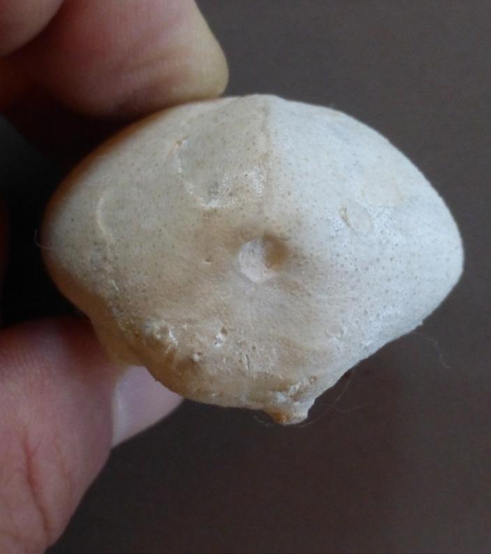
Any geologist worth their salt never forgets their first outcrop. In my case, this was a series of abandoned chalk quarries and gravel pits along the Chalk escarpment in West London, centred on the village of Harefield in Middlesex (Figure 1). I spent many happy afternoons cycling out to visit these localities to collect a variety of fossils; although, when I made my very first find (at the tender age of 8), a flint cast of the heart urchin, Micraster, I was driven out to the quarry by one of my long-suffering parents.
The outcrops provide a fascinating snapshot into the complexities of British stratigraphy, including a portion of the Upper Chalk, which features several marker beds, as well as a unique Eocene section recording a series of marine transgressions. While many of the quarries have been used for landfill, one site has recently been cleaned off, opening a window into the past. This has enabled us to use the sedimentary structures and fossils to help interpret the depositional settings.
GENERAL GEOLOGY OF HAREFIELD
The first geological record for the area that I could find dates to 1863, detailed in a publication by the Geologists’ Association. The stratigraphy was already well understood at that time. Most of the exposures around Harefield represent sections of the Upper Chalk, deposited in water depths of more than 200 m in a Cretaceous seaway that covered much of Europe and extended all the way to Australia. Deposition of the Chalk (famously exposed along the White Cliffs of Dover) was followed by a long period of emergence (and non-deposition) through much of the Paleocene that eroded the Chalk.
JON NOAD, STANTEC CONSULTING; UNIVERSITY OF ADELAIDE
Figure 1.
Map of the Colne Valley showing outcrops mentioned in the text.
Figure 3. Photograph of Springwell Chalk Quarry, Springwell Lane, taken in 1914.
A series of transgressions, approximately 56 million years ago, led to renewed deposition of mainly marine deposits in the London Basin, including the London Clay, which underlies most of UK’s capital city (Figure 2). Indeed, an Eocene fossil whale was found while excavating the foundations for St. Paul’s Cathedral. This period of deposition was followed by a further period of emergence and eventually by the Quaternary ice ages, during which glaciers scoured much of the remaining Chalk and glaciofluvial action deposited thick, glacial outwash gravels. This included the Taplow Terrace gravels deposited by a much larger glacial River Thames. In former times, most of the chalk quarries exposed excellent examples of glacial solution pipes.
MY CHILDHOOD LOCALITIES
Much of my teenage fossil collecting was undertaken in two abandoned chalk quarries (Figure 1): in Springwell Lane (Springwell Chalk Quarry or Pit, aka Harefield Quarry; Figures 3 to 5) and Summerhouse Lane (Summerhouse Chalk Pit; Figure 6). These pits closed in the 1940s and their only use since then has been as film sets and for landfill. Scenes from the British sci-fi series Dr. Who and Blake’s 7, as well as episodes of the Avengers and Randall and Hopkirk (Deceased) were filmed at Springwell Chalk Pit. I visited the quarry in the early 80s and saw a long scar on the quarry floor left by a film crew staging a spaceship crash landing.
The stratigraphy comprises a series of chalk beds from 20 cm to more than 1 m in thickness, punctuated by beds of black flints (Figures 7 and 8). The prevailing theory is that the flints represent fossil shrimp burrows, with organic content that acted as a nucleus for silica deposition. The silica was sourced from glass sponge spicules, forming a gel that migrated through the sediment and ended up preserving burrow casts. There are also lithified hardgrounds, with glauconitic and phosphatized intervals representing periods of non-deposition.
Figure 2. Geological section showing the London Basin syncline (from Sumbler 1996).
Figure 3. Photograph of Springwell Chalk Quarry, Springwell Lane, taken in 1914.
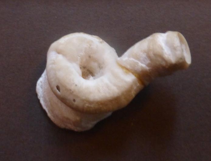
The Cretaceous macrofauna includes a variety of fossil sea urchins, including five species of irregular echinoids and the regular sea urchin Cidaris. There are also starfish and free-swimming crinoids. Molluscs include giant inoceramid oysters, reaching over a metre in diameter, and the spined Spondylus. There are also various fossil sponges, serpulid worms, brachiopods, and encrusting species of bivalve, bryozoa, and barnacles, which colonized the oysters and echinoderm tests. The general softness of the chalk lends itself to fossil hunting and extraction and successful preparation of hard-shelled invertebrates.
The chalk itself comprises myriads of coccoliths, a type of microfossil. The associated flints are very hard and resistant, so they are usually preserved as clasts during erosion of the chalk. Internal casts in flint of many invertebrates are preserved as fossils, representing the same fauna as seen in the chalk itself. Glacial gravels are often rich in fossil echinoderms and other casts and have been mined commercially along the Colne Valley (Figure 9).
ADAPTATIONS TO “LIFE IN THE SOUP”
The Cretaceous fauna was faced with challenges due to the very soft substrate. The chalk was deposited on an undulating seafloor, with ridges separating basins of regional extent. Large-scale mass movement, such as slumps and slides, were common. Much of the seabed was thixotropic (i.e., jelly-like) for the first 10–20 cm, with progressively firmer sediment beneath. The chalk, composed of the tests of billions of tiny coccoliths, was commonly remobilized by bottom currents.
The organisms handled the thixotropic conditions in a variety of ways. Sea urchins, such as Micraster and Echinocorys (Figures 10 and 11), lived infaunally and their tests were adapted to facilitate the passage of water
(with associated nutrients) from the test to the mouth and to remove waste from the anus. The evolution of these features over 30 million years makes them excellent zone fossils (Figure 12). Changes include the broadening and heightening of the test, deeper grooves in the test, more granular plates, and a shift in the location of the mouth and anus. They became more proficient burrowers, which may have guarded against predation by marine reptiles.
Regular echinoderms, like Cidaris, grew bulbous or lengthy spines, which may have helped to support themselves on the seabed (Figure 13), while starfish were flat and mat-like, behaving like snowshoes on the substrate. Similarly, bivalves, like Inoceramus, grew thin shells, up to 2 m in size, which may have provided support on the seabed. The shells provided a solid substrate for colonizing organisms, like bryozoans. The lamellibranch Spondylus spinosa grew spines up to four times the length of its shell that may have acted as props, rather than in a defensive capacity. Some crinoids evolved to become free swimmers, rather than requiring a holdfast, while many animals colonized empty tests on the seabed.
SUCCESSION AT HAREFIELD PIT (OLD CEMENT WORKS, AKA HAREFIELD BRICK AND CEMENT WORKS)
The succession exposed in the Pit has recently been cleaned up by members of the Harrow and Hillingdon Geological Society. The basal metre of exposure comprises part of the Cretaceous Upper Chalk, which has been extensively burrowed. The burrows are filled with sediment from the overlying Eocene deposits (including glauconite grains), indicating that the burrowing took place at that time. They are interpreted as burrows of fossil shrimps and have been named Glyphichnus harefieldensis (Figure 14).
Figure 4. View of Springwell Chalk Quarry, Springwell Lane, taken in 1949.
Figure 5. Springwell Chalk Quarry in 1913.
Figure 6. Summerhouse Lane Chalk Pit (photo by Diana Clements).
7. Composite section through the stratigraphy exposed at Harefield (drawing from personal observations; C.J. Wood 2004; Cooper 1976; Clements 2010; Whitaker 1872).
Figure
Figure 8. Chalk with flint nodules representing burrow casts.
Figure 9. View of the gravel pits stretching through the Colne Valley, Middlesex.
Figure 11. Different morphotypes of the Cretaceous sea urchin Echinocorys from Harefield.
Figure 10. Two species of the Cretaceous heart urchin Micraster from Springwell Chalk Quarry.
Figure 12. Evolution of test in Micraster in response to changing seabed conditions (from Rose and Cross 1993).
The bed immediately overlying the chalk is an 80–100 cm thick conglomerate dominated by subangular flint clasts, some with a glauconite rim and a sandy matrix with glauconite grains. This bed has been referred to as the Bullhead Bed and forms the basal portion of the Upnor Formation. It has also been described as a “greensand” due to the colour of the associated glauconite, a marine indicator mineral. These beds are dated as Late Thanetian (late Paleocene). The conglomerate is capped by 35 cm of pale-grey, clean sandstone with low-angle cross-beds, overlain by 150 cm of colour mottled clays of the Reading Formation, including silty deposits and further thin crossbedded sandstone beds (Figure 15).
The overlying beds are now very poorly exposed, but, previously, the slope overlying the Reading Beds featured outcrops of the Harwich Formation. A thin interval of mottled clays (brown with pale green streaks) of the uppermost Reading Beds is overlain by brown, sandy clays with “nests” (mudstone concretions) with a variety of fossil molluscs (Figure 16) with chalky shells. Occasional pebble horizons, which include comminuted shell material and rare shark teeth, occur at the bases of beds (Figure 17). These beds are assigned to the Tilehurst and Swanscombe members of the Harwich Formation. They are overlain by limonitic clays interpreted as the basal London Clay. The clays of the Harwich Formation have been dated as Early Eocene (Ypresian) or latest Paleocene (Thanetian).
HAREFIELD PIT: INTERPRETED DEPOSITIONAL SETTINGS
Our section can be interpreted as an initial marine transgression flooding over the Chalk. The common shrimp burrows and conglomerate and the presence of glauconite attest to a high-energy, marine setting. The overlying cross-bedded sandstone is thought to be a near-beach deposit, capped by alluvial plain deposits of the Reading Formation. The mottling is related to incipient pedogenesis (i.e., soil formation), while the interbedded sandstone beds represent small fluvial channel deposits. A further series of minor marine transgressions led to deposition of the shelly Harwich Formation and overlying London Clay with associated marine fossils, including a microfauna with ostracods. These are interpreted as coastal deposits, possibly estuarine.
14. Detail of the contact between the bored Cretaceous chalk with Glyphichnus harefieldensis and the overlying Upnor Formation conglomerate with glauconite at Harefield Pit.
Cidaris, echinoid
Inoceramus sp. of oyster
Serpulid worm tube
Gibbithyris, brachiopod Fossil sponge
Spondylus, bivalve
Figure
Figure 13. Variety of fossil fauna from Springwell Chalk Quarry.
It should be noted that the Eocene succession varies dramatically across the London Basin, and the description above only applies to the Harefield area. Harefield Pit is a Site of Special Scientific Interest (SSSI) due to its stratigraphic significance.
SUMMARY
In most parts of the world, you do not need to go far to find outcrops; although, these days, many quarries are closing and being used for landfill. The wide variety of deposits in the Harefield area kept me busy and fueled my interest in geology as a teenager. Despite the blanket description of “relatively unfossiliferous” in the Geologists Association’s guides covering my local area, I found enough fossils to build a picture of what life was like during both the Upper Cretaceous and the lowermost Eocene. Many people fostered my interest, particularly my parents and members of the local geological society, and I urge you to do the same for young people showing an interest in geology. They are undoubtedly the future of our science.
Figure 17. Fossil shark teeth, including Odontaspis and Striatolamia, sand sharks that may have grown up to 2 m in length, from the Harwich Formation of Harefield Pit.
REFERENCES
Aldiss, D.T. 2012. The stratigraphical framework for the Palaeogene successions of the London Basin, UK. British Geological Survey, Open report OR/12/004, 94 pp. Barron, H.F., Brayson, J., Aldiss, D.T., Woods, M.A. and Harrison, A.M. 2009. London’s Foundations. Supplementary planning guide issued in 2012. British Geological Survey. Brook, D., Clements, D., Lucy, G., Baker, L., Steveson, N., Collins, P., Rainey, P. and Marks, V. Guide to London’s Geological Sites. pp. 49-51. Clements, D.A. 2010. GA Guide No. 68: The Geology of London. Compiled by Diana Clements; Published by the Geologists’ Association. Colne Valley – Landscape on the edge. Landscape Conservation Action Plan - March 2018.
Cooper, J. 1976. Report of a field meeting to Harefield, Middlesex, 14.III.1976. Tertiary Research, 1, pp. 31–35.
Daley, B. 1999a. Introduction to the Palaeogene. 9-22 in British Tertiary Stratigraphy. Daley, B, and BALSON, P (editors). Geological Conservation Review Series, No. 15. Harrow & Hillingdon Geological Society. Evidence of past climates from local rocks. Holmes, T.V. 1894. Excursion to Harefield, Proceedings of the Geologists Association publication, p. 281-282.
Hopkinson, J. 1899. Excursion to Rickmansworth and Harefield, Proceedings of the Geologists Association, vol. 16, no. 5, p. 244-246.
Noad, J. 2018. Fauna of the Cretaceous Upper Chalk: Adapting to life in the soup: Royal Tyrrell Museum Speaker Series: https://www.youtube.com/ watch?v=Dog3RhYHNxg&t=827s
Noad, J. 2022. Fossils of Harefield, Middlesex. Posters: https://www.hhgs.org.uk/ Noad_HarefieldFossils.pdf
Rose, E.P.F. and Cross, N.E. 1993. The Chalk sea urchin Micraster: microevolution, adaptation and predation. Geology Today, September 1993.
Smith, A.J. and Batten, D.J. 2002. Fossils of the Chalk. Pub. The Palaeontological Association, ed. A.B. Smith and D.J. Batten, pp. 374.
Tracey, S. 1992. A review of the early Tertiary molluscs of Bognor Regis (Hampshire Basin), England. Tertiary Research, 13 (2-3), pp. 155-175.
Whitaker, W. 1872. The Geology of the London Basin. Part 1. The Chalk and the Eocene beds of the southern and western tracts. Memoirs of the Geological Survey, volume IV.
Figure 15. The basal Reading Formation at Harefield Pit.
Figure 16. Fossils from Harefield Pit: gastropods including Euspira; large Panopea; and abundant, tiny Martesia bivalves.
UPCOMING EDUCATION
REGIONAL GEOLOGY OF THE MONTNEY RESOURCE PLAY: WESTERN CANADA SEDIMENTARY BASIN
Tuesday, September 23 to Friday, September 26, 2025
8:15 AM - 4:30 PM
Instructor: Thomas F. Moslow, PhD., P.Geol. and John-Paul Zonneveld, Professor
Location: AER Core Research Centre
Online registration closes September 16, 2025
GEOLOGY FOR ENGINEERS
Tuesday, October 21 to Friday, October 24, 2025
8:30 AM - 4:30 PM
Instructor: Thomas F. Moslow, PhD., P.Geol. and Jean-Yves Chatellier, Tecto Sedi Integrated Inc.
Location: New CEGA Classroom and AER Core Research Centre
Online registration closes October 14, 2025
ALICE PAYNE - BREAKING THE GLASS CEILING
The First Woman President of CEGA, Legacy CSPG
TAKO KONING, P. GEOL., SENIOR GEOLOGIST - CONSULTANT
I am happy to report that one of CEGA’s most dedicated volunteers, namely Alice Payne, is still alive and kicking!
Alice Payne first learned geology as a young girl at her father’s side: as a prospector he set a good example by staking a gold mine in Yellowknife and later drilling for oil in Alberta. She was the only woman in her university graduating class due to barriers to women entering the profession. She had to fight for permission to do fieldwork. Alice embarked on a trailblazing career in mining geology and later in petroleum geology, becoming the first woman president of the Canadian Society of Petroleum Geologists. From early on, she always encouraged young women to enter non-traditional careers.
Alice Victoria Payne was born in Edmonton and attended primary and secondary school in the Highlands area in east Edmonton. Her high school years were at Havergal College in Toronto. She obtained her B.Sc. (Hon. Geology) in 1962 and M.Sc. in Geology in 1965, both degrees from the University of Alberta.
Her first fulltime job was with the Geological Survey of Canada. While raising a family of two, she worked in the mining industry as a consultant doing geological research and project management. Her consulting work was with both industry and academia. She explored for gypsum, uranium, other minerals and coal. Alice’s work had her living in Edmonton, Ottawa, and short-term locations all over the north country. From 1978 to 1990, she was the director and secretary-treasurer for Ryan Gold Mines.
Alice Payne is her office at Gulf Canada Resources Ltd.
PHOTO FROM QUIN KOLA: TOM PAYNE’S SEARCH FOR GOLD.
Alice published several papers on natural resources. In 1965 she was the senior author for a paper titled, “A Line of Evidence Supporting Continental Drift”. Co-authors included the University of Alberta’s Drs. Baadsgaard, Burwash, Cumming, Evans and Folinsbee. The paper was published in in the proceedings of the Upper Mantle Symposium of the International Union of Geological Sciences held in 1995 in New Delhi, India.
In 1979, Alice made a major career transition pivoting from the mining industry to the oil industry when she was hired as senior exploration geologist by Gulf Canada Resources Ltd. She relocated to Calgary and continued with Gulf for 16 years until her retirement in 1995.
Alice was a pioneer in many ways, and this was highlighted when in 1992 she became the first woman president of the CSPG (Canadian Society of Petroleum Geologists). After moving to Calgary, Alice became an active volunteer with the CSPG. In 1983, she was chairperson of the entertainment committee of the CSPG Annual Convention. She served as the Society’s treasurer from 1988 - 1989. In 1991, Alice helped to ensure completion of the Geological Atlas of Western Canada. In 1995 –1996, she was chairperson of the Stanley Slipper Gold Medal Committee. Also in 1996, she had a major role in raising funds for the Pools ’96 CSPG Convention with her efforts contributing substantially to the financial success of the conference.
Besides her volunteering for the CSPG, Alice was also involved with other industry-focused organizations. For example, in 1990 she was appointed as Chairperson of the Premier’s Council for Science and Technology for Alberta.
In 1996, Alice received the CSPG President’s Award. The citation reads: “Perhaps the most endearing of aspects of Alice’s Society activities is that she always has an opinion and is eager to get involved. Further, she always has the best interests of the Society at heart and is willing to listen to others and work with anybody regardless of divergent opinions. The Society needs more members like Alice Payne”.
Thereafter in 1997, Alice was appointed to be a member of the Order of Canada. The citation reads: “She achieved a lifelong dream of pursuing a career as a geologist in spite of early limitations on women entering the profession. Due to her talent and perseverance, she went on to work as a geologist at one of Canada’s major oil exploration companies and became the first woman to serve as President of the Canadian Society of Petroleum Geologists. She continues to take part in programs aimed at encouraging young women to pursue careers in non-traditional fields”.
In 1998, the YWCA awarded Alice with the Woman of Distinction Award for Science, Technology and the Environment. In 2000, she received an Honorary Doctor of Laws degree from the University of Calgary. In 2002, Alice received the Queen Elizabeth II’s Golden Jubilee Medal.
Alice’s energy never let up, even in retirement. Indeed, in 2000, Alice wrote her book titled Quin Kola: Tom Payne’s Search for Gold. This book is about her father’s adventures while searching for minerals in northern Canada which led to the discovery of a gold mine in Yellowknife. The book stated the following: “Alice enjoys family life, horseback riding, hunting, reading, and gardening. Whenever possible, she still travels
with her geological hammer and resource maps. She believes in following one’s dreams, persevering through adversity and promoting the natural talents of others. Through her community exchanges, she has shown many students that science can be fun and meaningful”.
After her book was published, Alice received the Distinguished Lecturer Award from the Canadian Institute of Mining, Metallurgy and Petroleum, in 2003. She gave talks about her book at several mining camps throughout Canada including Red Lake, Flin Flon and diamond mines near Yellowknife.
Younger people now working in Canada’s oil industry have no idea of the difficulties facing working women back in the mid-1900’s. Women were generally expected to stay home, raise kids, while the husband was the “bread earner” and “brought home the bacon”. Women were barred from working on oil drilling rigs, especially the offshore rigs. Women were even denied membership in the Calgary Petroleum Club until 1989. Taking all this into account, Alice certainly did break the glass ceiling when she was elected President of the CSPG back in 1992.
Alice now lives in Cochrane AB where she keeps active curling, keeps fit doing aquacise and spends time with friends and family, including three grandchildren. On March 19, 2025, Alice reached the golden age of 85. She continues to volunteer for CEGA on the Honorary Membership Committee. In my opinion, Alice Payne serves as a role model for CEGA members – young, middle aged and older (like myself) - to continue to volunteer and to try to make a difference at any age.
Photo from the 1940s, Tom Payne takes Alice (left) and her younger sister Elizabeth out for a paddle at Jolliffe Island in Yellowknife.
PHOTO COURTESY OF ALICE PAYNE.
Alice in Maui, Hawaii, 2024.
PHOTO COURTESY OF ALICE PAYNE.
The Blue View: Industry Trends Through Woodmac’s
NORTH AMERICA IN CONTEXT: OVERARCHING THEMES ACROSS THE INDUSTRY
1.
Whitecap and Veren merge into seventh largest Canadian producer
CANADA
2.
Public vs private emissions trends and benchmarking
3.
Armstrong, APA and Santos reel in Sockeye discovery in Alaska
n Whitecap and Veren merge into seventh largest Canadian producer
Whitecap Resources and Veren are combining in a merger of equals under the Whitecap name and management. The combined entity will have assets in the Montney, Duvernay, and conventional bases throughout Alberta and Saskatchewan. Whitecap will become the 7th largest Canadian oil and gas producer with 2025 production of 370,000 boe/d, 63% liquids.
The company anticipates annual synergies of over C$200 million. Asset overlap is considerable in both growth and conventional areas. The combined company will have 1.5 million Montney and Duvernay acres and remain the second largest producer in Saskatchewan.
UNITED STATES
n Methane emissions by source and peer group
Key takeaways:
• Public operator methane emissions intensity in 2023 was 50% lower than the private peer group. Our covered public companies emit more on an absolute level;but they also produce more. On a per boe basis, emissions are much lower for public names.
• The private peer group has reduced methane emissions intensity by 59% since 2019 Although notably, these operators started at a higher level of emissions. Over the past two years, many high growth privates were acquired by public companies too. Progress on emissions reductions by privates does deserve a call out.
• Venting, flaring and pneumatic devices remain the largest emissions sources. Most operators are targeting these emissions sources as abatement solutions are lower cost and straight forward. For example, retrofitting natural gas driven pneumatic devices with air or nitrogen can offset ten or more metric tons CO2e per unit. Based on public company communication, we do expect pneumatic device emissions to reduce further in the 2024 EPA data set.
Both companies had pivoted to similar long-term strategies, acquiring assets in the Montney and Duvernay to replace reserves and provide growth opportunities. The pro forma balance sheet will improve, with Whitecap retaining its dividend and expecting significant free funds flow in 2025.
This merger of equals allows the combined company to achieve greater scale more quickly than either could alone, potentially improving marketing strategies and access to LNG supply deals.
Source: Wood Mackenzie. EPA GHGRP subpart W data. Private peer group includes thirty-five of the most notable private operators since 2019 across Lower 48. Public peer group includes thirty-five companies within Wood Mackenzie’s upstream coverage.
• Robust leak detection and repair (LDAR) programs are working, too. Emissions associated with equipment leaks have reduced since 2019 by 63% and 41% for the private and public company groups, respectively. Sustainability reports highlight LDAR programs for nearly every operator, with Optical Gas Imaging (OGI) and other technologies being deployed as well.
n Armstrong, APA and Santos reel in Sockeye discovery in Alaska
The Alaska North Slope consortium comprised of Armstrong Oil & Gas, APA and Santos (the “Consortium”) announced a discovery at Sockeye-2. The well was drilled to a depth of 10,500 feet and encountered 25 net feet of oil pay.
Expectations are high given the better-than-expected porosity of 20%, healthier than analogue fields in the Brookian-aged Nanushuk play. Within the Consortium, APA Corporation holds a 50% stake with Santos and Armstrong owning 25% each.
This discovery follows the King Street technical discovery and Voodoo dry hole drilled last winter by the same consortium. The Sockeye find is part of a renewed focus on exploration in the region, aiming to diversify the corporate landscape currently dominated by ConocoPhillips, Hilcorp, ExxonMobil, and Santos. The King Street-1 discovery (drilled in 2024, 27 kilometres west of Sockeye-2) also indicated oil pay in two Brookian zones, but its size remains under evaluation. Wood Mackenzie estimates the King Street discovery size to be around 100 mmboe. We estimate Sockeye could have in-place resource of 560 mmbbls and total recoverable resource of 150 mmboe.
Armstrong, responsible for early Nanushuk success at Pikka, has been exploring the shallower, previously overlooked formation in the eastern North Slope. Their 325,000-acre exploration position is on stable state lands, making it attractive for development.
The timing is advantageous for both the state and project partners. Further delineation and drilling of nearby prospects will likely precede any large-scale development spending, which suits APA and Santos, given their current capital investment demands in Suriname and Alaska Pikka projects.
Nanushuk reservoirs are entering their development era, with Pikka and Willow expected to provide significant production growth. Pikka’s construction is 80% complete for a mid-2026 production start-up.
Early well results from ConocoPhillips’ Coyote, Nuna, and Narwhal projects provide encouraging analogue data. The Coyote 3S-704 well has already recovered 950,000 barrels with minimal monthly declines, while the 3S-722 well has shown even stronger initial production rates. Narwhal wells are also performing well, with one peaking at 3,600 b/d. Production tests from Sockeye to the east will be closely watched to see if and how higher porosity translates to higher production rates.
Alaska exploration has taken a back seat in recent years as the Nanushuk discoveries of the last decade shifted to development, but exploration is expected to pick up again to provide growth avenues for the next decade. Exploration, like with the Sockeye-2 example, will also serve as an opportunity to diversify the corporate landscape currently dominated by ConocoPhillips, Hilcorp, ExxonMobil and Santos.
SCOTT NORLIN, GIT
Research Analyst, Upstream Canada
Scott joined the Canadian Upstream Research team at Wood Mackenzie in June 2019. He is responsible for providing financial asset valuation and objective commercial analysis on company and play activity across Canada. His coverage ranges from North American large caps to junior private producers. He also covers CNRL and Cenovus for the corporate analysis team, providing high level company valuation and strategy analysis.
XIN YI
Research Associate, Canadian Upstream Research
Xin's responsibilities include financial asset valuation and emissions modelling for Canadian and Alaskan assets. She also contributes to corporate analysis for Canadian and international mid caps and large caps such as Tourmaline Oil and Chevron.
DISCLAIMER – THE VIEWS AND OPINIONS STATED BELOW ARE BASED ON WOOD MACKENZIE’S DATA, SOURCED FROM PUBLIC SOURCES ACROSS THE GLOBE AND OUR PROPRIETARY TOOLS SUCH AS LENS.
2024 STANLEY SLIPPER AWARD
The Stanley Slipper Gold Medal for 2024 is awarded to Dr. James (Jim) M. Wood, in recognition of his outstanding 35-year career in the Canadian petroleum industry. Jim has worked for several oil and gas companies, published ground-breaking exploration technical ideas, and influenced many geoscientists in western Canada. He is best known for his contribution to derisk the early exploration and multi-well pad development drilling of the enigmatic Montney tight gas play through complex geological data analysis, well before the development of today’s horizontal completion technology. His early contributions significantly contributed to the success of the Montney play becoming Canada’s premier unconventional petroleum play.
DR. JAMES (JIM) M. WOOD
After graduating from the University of Aberdeen with a B.Sc. in Geology in 1979, Jim was drawn to the University of Calgary by the Rocky Mountains and an exciting M.Sc. program. With Richard Thomas as supervisor, Jim focused on logging and mapping tide-influenced fluvial paleochannel outcrops characterized by heterolithic point-bar deposits. The cross- pollination of ideas between University of Calgary geologists (Thomas, John Visser, Wood) and geographers (Derald Smith, Anne Calverley) led to the proposal of a new descriptive term for these deposits in a landmark 1987 publication: Inclined Heterolithic Stratification – Terminology, Description, Interpretation and Significance. Today, IHS is an industry- standard term for describing, interpreting, and exploiting meandering channel deposits in the McMurray oil sands.
An industry downturn coincided with his M.Sc. graduation in 1985, and Jim turned his focus to Ph.D. research on the Glauconite Formation. Jim credits his supervisor, John Hopkins, with instilling the value of applied research for improved understanding of reservoir geology. Jim’s research took a “sequence stratigraphic approach for the recognition of estuarine reservoir sand bodies within incised valley-fill deposits” and these models are still applied by explorationists today working on the Mannville Group in southern Alberta. Jim presented his Ph.D. work at
a CSPG technical lunch and was subsequently awarded the CSPG Link Award for the best oral presentation in 1990. This event also led to Dave Thomas at Petro- Canada offering Jim his first industry position. After another industry downturn, Jim had to leave Canada (given his one-year work visa), and he moved to the Middle East to work with Core Lab Abu Dhabi. Jim then worked for Schlumberger Dubai on the giant Marjan and Safaniya fields, offshore Saudi Arabia, “applying sequence stratigraphic methods to reservoir characterization and geocellular modeling.”
During a visit to Calgary for the CSPG convention, Jim fortuitously met Ian McIlreath of PanCanadian. Ian subsequently pursued crucial immigration support enabling Jim to work in Canada. Jim is grateful for Ian’s extra efforts that “changed both my career path and the arc of my life.” From 1994 to 1996, Jim worked for PanCanadian on a variety of projects and gained valuable insight into the business side of petroleum geology.
In 1996, Jim joined Crestar Energy where he worked on a range of exploration projects (Bakken, Mannville, Sawtooth, Viking, and shallow gas). Several oil and gas discoveries followed. Jim still recalls the complexity of the Bakken play due the effect of late dissolution of the underlying Devonian salt.
In 2001, Jim rejoined PanCanadian. Alberta Energy Company merged with PanCanadian in 2002 forming Encana/Ovintiv, which became “home” for Jim for 18 years. Early on, Jim joined a team tasked with screening the entire sedimentary stack in western Canada for unconventional resource plays. “The team, under Brian Tuffs, quickly deemed one play, the Montney unconventional gas play, to have remarkably greater potential than any of the others.”
After handing over regional stratigraphic mapping responsibilities to others, Jim focused on understanding the confusing reservoir and fluid properties that plagued consistent well production results and play economics. This challenge was huge because horizontal completion technologies were in their infancy. Jim initiated research collaboration with Chris Clarkson at the University of Calgary, which then led to further research collaborations with Amin Ghanizadeh (University of Calgary), Hamed Sanei and Omid Ardakani (Geological Survey of Canada), Hassan Dehghanpour (University of Alberta), Takashi Akai (Japan Oil, Gas and Metals National Corporation), and Mark Curtis (Oklahoma University). This research encompassed many lesser studied aspects of the Montney like organic matter, solid bitumen, thermal maturity, wettability, cementation, and geomechanics.
When natural gas prices collapsed in 2014, Dr. Wood was tasked to make sense of the chaotic distribution of liquids-rich Montney wells. Jim turned to routine gas analyses. He knew from publications on the Barnett Shale that it might be possible to see trends within these tight unconventional plays using simple gas analyses. Jim determined that his plots of Montney methane content versus butane isomer ratio (iC4/nC4) indicated a higher methane content than expected for a given butane isomer ratio. He reasoned that “excess methane” was due to secondary migration, and causing some areas to be liquid-poor. The mapping of gas data consistently “revealed distinct migration pathways that neatly explained closely spaced wells with low and high CGRs (condensate-gas ratios).” Genga Nadaraju writes “Jim brought geoscience and petroleum engineering focus on developing practical applications for the enhanced evaluation and economic development of gas and liquid hydrocarbons in the unconventional Montney resource play for Encana/Ovintiv. His focus has been on the practical application to the oil and gas industry, particularly his contribution to the exploration and development of the Montney play.” Genga also credits Jim with being the key technical liaison to Encana’s partners, Mitsubishi and Kogas.
Jim is grateful to several managers at Encana such as Cam Buss, Randy Hnatiuk, Chris Wilcox, and Genga Nadaraju, who allowed publication of his research, including a landmark 2016 paper in Nature Communications with co-author Hamed Sanei: “Secondary migration and leakage of methane from a major tight-gas system”.
Other Montney operators quickly applied these techniques, and Montney play reserves continued to grow significantly in both British Columbia and Alberta. Chad Glemser, a Shell Canada geologist at the time, writes that the Nature publication was “a ground-breaking paper for understanding fluid and gas distributions. It also unlocked vast resources within the Montney, explained the overpressure regions compared with the normally pressured regions, and why water production could be expected within certain layers.” Chad writes that “Shell applied the secondary dry-gas migration theory, and it worked.”
Lana Sharp, manager Geoscience at Ovintiv, worked with Dr. Wood from 2015-2018 and says that Jim was “responsible for defining the sequence stratigraphy, delineating liquids, and pushing development into new areas and benches. He was also instrumental in developing a gold standard for Montney core analysis that accurately predicts BVW (bulk volume water). Without his findings, I do not think we would be where we are today as an industry in Canada.”
Following another industry downturn in 2018, Jim accepted early retirement in 2019. Jim was soon consulting for other Montney operators with Calaber1 Resources, a division of his own family business, Wood Innovations Inc. In April 2021, at the request of Genga Nadaraju, Jim became Director of Geoscience at Avanti Helium Corp., overseeing geoscience aspects of Avanti’s helium exploration program in Canada and the USA. Two of Avanti’s exploration wells flow tested at commercial rates with 1.1% helium content. Helium production from these wells is anticipated in 2025.
Jim is the author of over 100 published articles and conference papers. He is a frequent contributor to Geoconvention conferences, and his oral talks are considered to be the leading edge of Montney interpretation. Many geologists have praised Jim’s mentorship of junior geologists and summer students at Encana and other companies. His Montney half- day short course, Montney Rock and Fluid Properties: An Introduction, has been attended by hundreds of geoscientists and engineers.
Jim has been a volunteer for CSPG/CEGA and other technical organizations over his career. He was a distinguished lecturer for the CSPG in 1991. In 1997, he was Co-Chair of the Core Conference at the joint CSPG-SEPM convention. Jim was also Associate Editor of the Bulletin of Canadian Petroleum Geology from 1996-2002. In 2019, he co-chaired the Gussow Conference on unconventional reservoirs. In 2024, Jim was on the organizing committee and a session chair for the Gussow Conference on the Montney Formation. He received CSPG volunteer awards in 1998, 2002 and 2003.
Dean Royer, a geologist at Pipestone Energy, who was mentored by Dr. Wood at Encana, praises Jim’s technical leadership. “Jim’s collaboration across industry and academia has allowed for significant dissemination of his impactful ideas into published works, universities, consortiums, and short courses. The range of Jim’s contribution to the Montney cannot be overstated.”
Jim is grateful for the many opportunities he has had in the industry. “A long professional career as a petroleum and helium geologist is built upon continuous learning, adapting to new circumstances and learning from many incredibly insightful colleagues.” He also notes his career would not have been possible without the loving support of his family.
Dr. Jim Wood’s outstanding technical leadership for the early industrywide commercial exploitation of the regional Montney gas play, Canada’s premier gas play, his mentorship and industry collaboration activities, and his outstanding impactful publications throughout his career, make him the deserving recipient of CEGA’s Stanley Slipper Gold Medal for 2024.