cegageos.ca THE MAGAZINE OF CANADIAN ENERGY GEOSCIENTISTS MAR/APR 2024 • ISSUE 2 • VOL 51 Reservoir
6 A Story of Fertilizer and the Colour Purple
24 The World’s Oldest Oilfield: The Witwatersrand of Welkom, South Africa
32 2023 Stanley Slipper Award
34 Honorary Membership Award
35 Honorary Membership Award
36 2023 Patricia J. Lee Trailblazer Award
38 The Blue View: Industry Trends Through Woodmac’s Lens
RESERVOIR ISSUE 2 • MAR/APR 2024 3 MAR/APR 2024
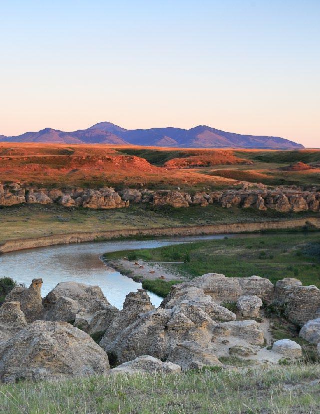
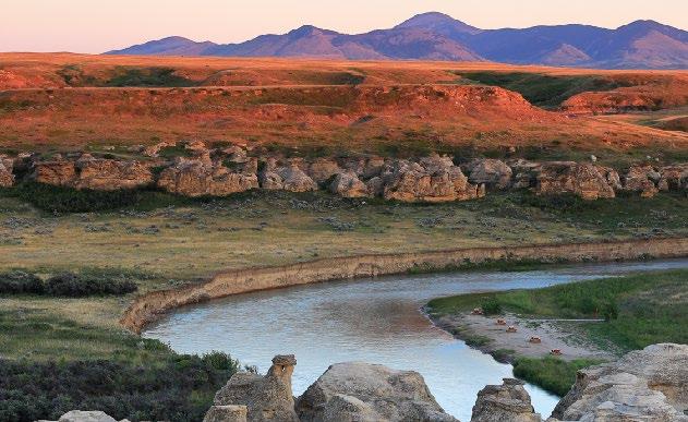
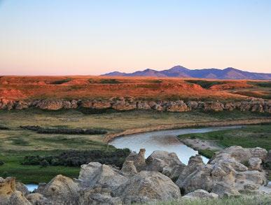
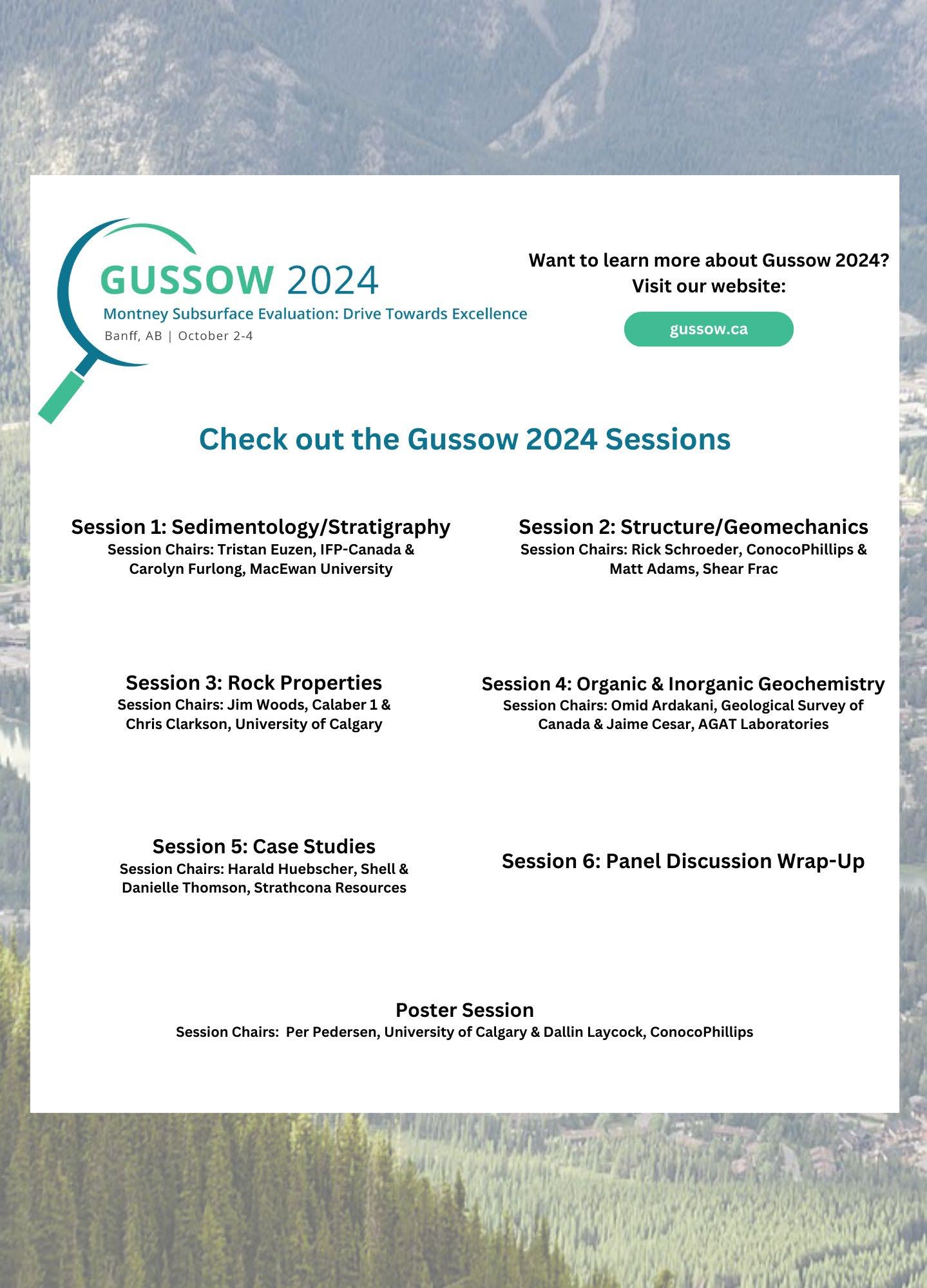
CONFERENCES UPCOMING EVENTS In This Issue GUSSOW 2024 PAGE 37 EETIG 2024 PAGE 2 CORE CONFERENCE PAGE 41 EVENTS INFORMATION PAGES 22 Southern Alberta Panorama Milk River, a northern tributary of the Missouri River, has carved a valley through nearshore and coastal sandstones of the Virgille Member of the Upper Cretaceous Milk River Formation (Santonian, 84 Ma) in Writing-on-Stone Provincial Park. This meandering river is reworking Recent valleyfilling sediments and displays a classic point bar (upon which the picnic tables are situated) and cut bank. On the skyline to the south, just across the border into Montana, is West Butte (2128 m) of the Sweetgrass Hills, part of a 50 Ma diorite-dominated intrusive complex. The intervening plain is capped by Quaternary sediments. The sandstones have been sculpted into Hoodoos whose faces have been inscribed by First Nations with petroglyphs and pictographs. The park was designated as a UNESCO World Heritage Site in 2019. Photo by: John Andersen

PUBLICATIONS INFORMATION
The RESERVOIR is published 6 times per year by the Canadian Energy Geoscience Association. The purpose of the RESERVOIR is to publicize the Association’s many activities and to promote the geosciences. We look for both technical and non-technical material to publish.
The contents of this publication may not be reproduced either in part or in full without the consent of the publisher.
No official endorsement or sponsorship by the CEGA is implied
for any advertisement, insert, or article that appears in the RESERVOIR unless otherwise noted. All submitted materials are reviewed by the editor. We reserve the right to edit all submissions, including letters to the Editor. Submissions must include your name, address, and membership number (if applicable). The material contained in this publication is intended for informational use only.
While reasonable care has been taken, authors and the CEGA make no guarantees that any of the equations, schematics, or
devices discussed will perform as expected or that they will give the desired results. Some information contained herein may be inaccurate or may vary from standard measurements. The CEGA expressly disclaims any and all liability for the acts, omissions, or conduct of any third-party user of information contained in this publication. Under no circumstances shall the CEGA and its officers, directors, employees, and agents be liable for any injury, loss, damage, or expense arising in any manner whatsoever from the acts, omissions, or conduct of any third-party user.
4 RESERVOIR ISSUE 2 • MAR/APR 2024
BOARD OF DIRECTORS 2024
PRESIDENT
Andrew Vogan ConocoPhillips Canada Ltd. president@cegageos.ca LinkedIn

FINANCE DIRECTOR ELECT
Rachel Lea Suncor Energy directorfinanceelect@cegageos.ca LinkedIn
DIRECTOR
Scott Leroux Mancal Energy Inc. education@cegageos.ca
Linkedin
PAST PRESIDENT
Simon Haynes Haynes Geological Consulting pastpresident@cegageos.ca LinkedIn

DIRECTOR
Gary Bugden Cabra Consulting Ltd membershipdirector@cegageos.ca Linkedin
DIRECTOR
Michael Livingstone Eathie Consulting Limited technicaldivisions@cegageos.ca LinkedIn
PRESIDENT ELECT
Shelley Leggitt Kiwetinohk Energy Corp. presidentelect@cegageos.ca LinkedIn
DIRECTOR
Ross Kukulski Chevron Canada publications@cegageos.ca LinkedIn

DIRECTOR
Michelle Thoms Freehold Royalties Ltd. outreach@cegageos.ca Linkedin
FINANCE DIRECTOR
Scott Norlin Wood Mackenzie directorfinance@cegageos.ca
CEGA OFFICE
#150, 540 - 5th Ave SW
Calgary, Alberta, Canada T2P 0M2
Tel: 403-264-5610 | cegageos.ca
OFFICE CONTACTS
MEMBERSHIP INQUIRIES
Tel: 403-264-5610
Email: membership@cegageos.ca
ADVERTISING INQUIRIES
Britney Tang
Tel: 403-513-1230
Email: britney.tang@cegageos.ca
Linkedin DIRECTOR
Marcelina Labaj Central European Petroleum Ltd. fieldtrips@cegageos.ca
Linkedin
DIRECTOR
Kevin Webb Aquitaine Energy Ltd. conferences@cegageos.ca
Linkedin
CONFERENCE INQUIRIES
Kristy Casebeer
Tel: 403-513-1234
Email: kristy.casebeer@cegageos.ca
MANAGING DIRECTOR
Emma MacPherson
Tel: 403-513-1235
Email: emma.macpherson@cegageos.ca
RESERVOIR ISSUE 2 • MAR/APR 2024 5
A STORY OF FERTILIZER AND THE COLOUR PURPLE
1. INTRODUCTION
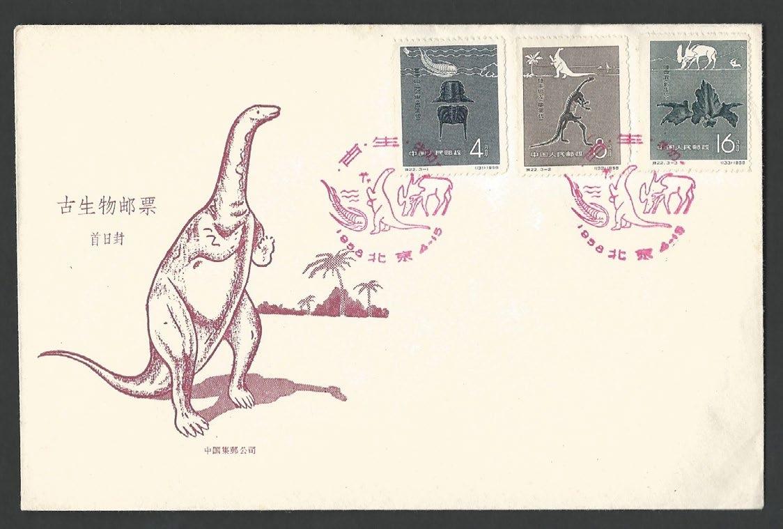
It is sometimes difficult to admit that you are (officially) a nerd, but I have a confession to make: I have collected dinosaurs on stamps for the last thirty years. Over 10,000 of these stamps have been issued across the world, and the vast majority of these issues are in my collection. One question that I am often asked is when the first dinosaur stamp was issued, which turns out to be the Chinese 1958 “Chinese Fossils” set of three stamps, one of which features Lufengaosaurus. This dinosaur was originally discovered in 1930 in Upper Triassic sediments of the Yunnan Province in southwest China. The delightful first day cover shows a shy prosauropod resting on its tail (Figure 1.1).
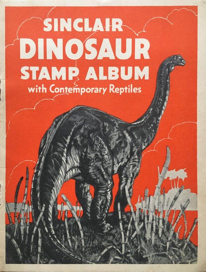
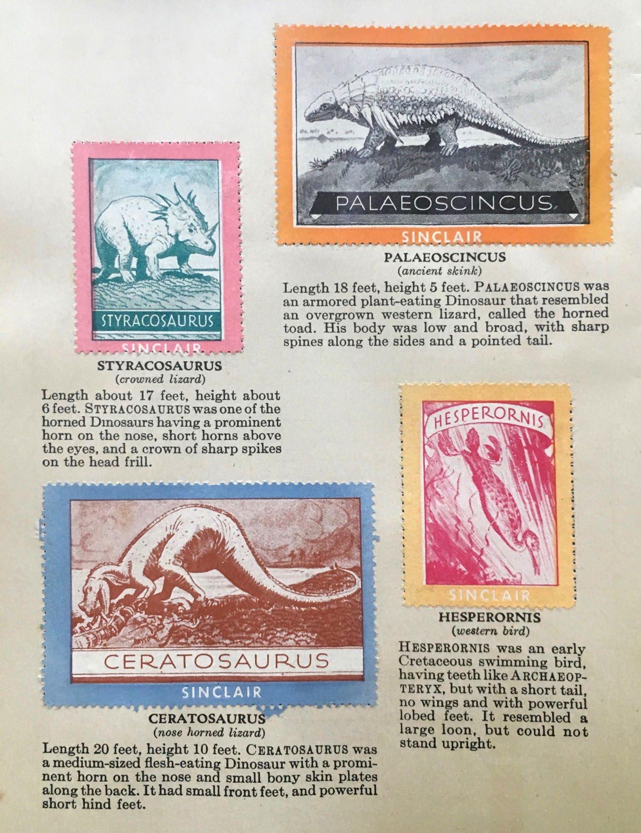
Things become more complicated when you broaden the definition to include any postal items like cinderellas (i.e., virtually anything resembling a postage stamp, but not issued for postal purposes by a government postal administration) and more. The Sinclair Oil Corporation’s official brand mascot is Dino, a large green sauropod. This image has featured on many giveaways, including stamps that could be stuck in albums. The first set of Sinclair dinosaur stamps was published back in 1935 (Figure 1.2), with four million albums distributed to the public, testifying to successful petroleum marketing. Another early dinosaur stamp, painted by John Heber Stansfield, was issued by the Utah Tourist Board around 1932. It showed a large dinosaur skeleton and publicized the state’s Dinosaur Monument (Figure 1.3).
6 RESERVOIR ISSUE 2 • MAR/APR 2024
PART 9
FIGURE 1.1 China 1958 Prehistoric fossils, set of stamps on First Day Cover.
FIGURE 1.2 Dinosaur stamps (Cinderellas) produced by Sinclair Oil in 1935.
Jon Noad, Stantec Consulting; University of Adelaide
RESERVOIR ISSUE 2 • MAR/APR 2024 7
FIGURE 1.3
Advertising stamp produced for tourism: Dinosaurs in Utah, painted by John Heber Stansfield around 1934.
2. (PERHAPS) THE OLDEST PHILATELIC DINOSAUR
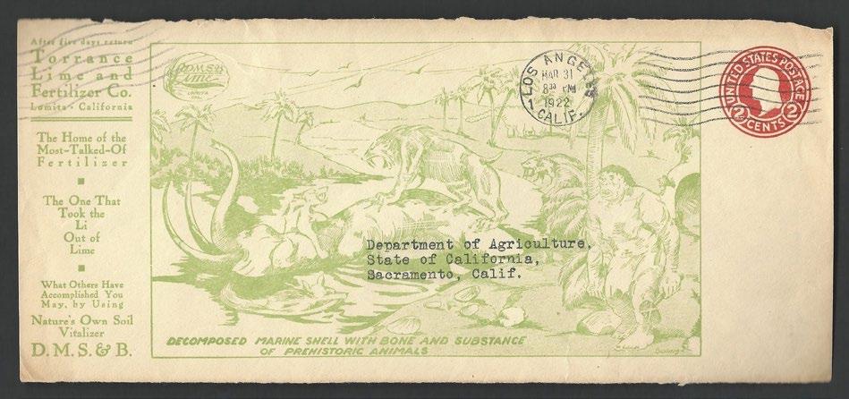
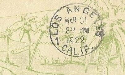
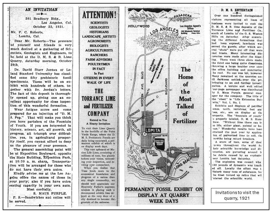
These cinderellas are nearing their centenary, but I have one postally used envelope in my collection that outdoes them all. Knowing of my interest in dinosaur philately, years ago an American stamp dealer gave me a unique prepaid cover (Figure 2.1), originally sent to the Department of Agriculture by the Torrance Lime and Fertilizer Company, of Lomita, California, in 1922. The envelope has an embossed stamp, in addition to a printed sketch showing a wide variety of ancient animals, including a somewhat dubious dinosaur sketch (Figure 2.2). The cover raised so many questions for me. What was this company? Why were there ancient animals (and a caveman) pictured on the cover? What was originally in the envelope? Was the company still in business? The more I researched these questions, the more data I uncovered, spanning social history, geology and palaeontology.
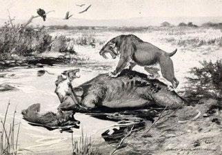
Examining the envelope (Figure 2.1), the most striking detail is the large sketch in green ink. It shows a saber tooth tiger (Smilodon californicus) roaring as it stands over a Columbian mammoth carcass (Mammuthus
columbi) in a tar pit. Several dire wolves (Canis dirus) are squaring up the big cat, while a solid-looking caveman stands to the right. A small, wobbly sauropod dinosaur (Figure 2.2) stands in the shade of the palm trees in the background. Also of note is the marine shell on the company logo (upper left) and further shells in the foreground. The basis for the main sketch was an original drawing (Figure 2.3) by Robert Bruce Horsfall for the book “A History of Land Mammals in the Western Hemisphere“, written by Robert Berryman Scott, [1] dating back to 1913. The Neanderthal figure is from a 1920 Chicago Field Museum diorama. The dinosaur on the cover appears to have been added at the last minute by someone who was NOT an artist!
The envelope itself is a piece of “postal stationery,” i.e., it has a stamp printed directly onto the envelope to pay the postage. The envelopes were sent to the post office, where the stamps were struck on paper, referred to as “stamped to order” or STO. Paper had to be submitted flat and unfolded, and stamping was done with the same embossing presses
as used for post office envelopes. In 1922, the date of the postmark on the envelope, the domestic postage letter rate was 2 cents/oz. The embossed image, carmine in colour, shows George Washington.
The envelope is postmarked March 31, 1922, which was a Friday. On that day, KFI-AM in Los Angeles, CA, began radio transmissions and Prince Hendrik opened a trade fair building in Amsterdam. The actor Patrick McGee (A Clockwork Orange; Barry Lyndon) was born in Armagh, Northern Ireland. Temperatures in Los Angeles reached 61° F, with a low of 50° F and no precipitation.[2] Across the world that year, Russia was enduring a terrible famine, Mussolini's Fascist Party seized control of the Italian government, Stalin was appointed General Secretary of the Communist Party, Egypt gained independence from Britain, the first successful insulin treatment of diabetes was made, and the silent film Nosferatu premiered in Berlin. The US President made his first speech on the radio, the BBC was created, and the Hollywood and Rose Bowls opened.
8 RESERVOIR ISSUE 2 • MAR/APR 2024
FIGURE 2.1 Postal stationery sent by Torrance Lime and Fertilizer Company in 1922.
FIGURE 2.2 Detail of dinosaur on cover.
FIGURE 2.3 Original artwork painted by Robert Bruce Horsfall for A History of Land Mammals in the Western Hemisphere, published in 1913, and shamelessly copied for the Torrance Lime and Fertilizer Company envelope and publicity material.
3. TORRANCE, CALIFORNIA
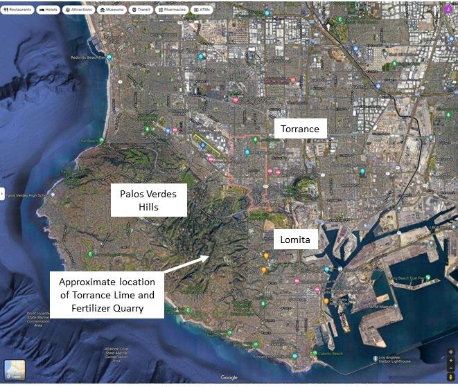
Torrance was founded on May 31, 1911, by Jared Sidney Torrance through the purchase of 2791 acres of land from the Dominguez Estate Company for $976,850. Other names were considered (including Southport, Coronel and Industrial) but the board approved the resolution calling for Torrance, over the objections of Jared. The city was incorporated on May 21, 1921.[8] It is a coastal city in the Los Angeles metropolitan area in California (Figure 3.1).
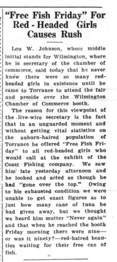
By far the most fertile source of information about everything Torrance, including the Fertilizer Company, can be found in the newspaper archives of the time.[9] The Torrance Herald was the city's newspaper of record from 1914 to 1969. The Herald started as an advertising sheet singing the praises of the new "modern industrial city" and evolved into the premier newspaper of the rapidly developing city. The Torrance Enterprise also
began as an advertising sheet that grew into a newssheet.
Throughout the 1920s, both papers chart the rapid growth of the city, while sharing some wonderfully parochial tales: who was taking tea with whom, who had been bitten by a dog and much more. Newspaper headlines in 1921 included “Lamp posts painted”, “Truck stuck in the mud”, “White Gopher Caught” and, in 1922, “Huge melon on display” and “Free Fish Friday For Red Haired Girls Causes Rush”. Much of the information in this article that relates to the Torrance Lime and Fertilizer Company is drawn from these newspaper archives.
Scouring the pages in early 1921, adverts promoting Torrance as a growing city, sponsored by the Dominguez Corporation, took pride of place in every issue. There were also stories every Friday (the day that both newspapers were published) relating to the Torrance Lime and Fertilizer Company (see
section 6). In a newly founded community, somewhat short of real news, it is likely that sponsorship by the company enabled them to place abundant stories about the efficacy of their fertilizer but, as we shall see later, the company went way beyond this.
The fame of the Fertilizer Company was short lived. On February 26th, 1921, the ChanslorCanfield Midway Oil Company (CMO) spudded a well in Torrance. The Torrance Herald reported a major strike at the Santa Fe Well No. 1, two miles from town on Aug. 18, 1921, and another gusher at the well occurred on Dec. 7, 1921 (Figure 3.2). The find came to be known as the Del Amo Field, with the well initially coming in at a rate of 2,500 barrels a day. Soon, a belt of wooden oil derricks carpeted the southern half of the city, stretching from the Southwood area to present-day Harbor City and Wilmington. The oil rush gradually “out-newsed” the stories of fertilizer mining.
RESERVOIR ISSUE 2 • MAR/APR 2024 9
FIGURE 3.1 Map showing quarry locations mentioned in article, located north of Los Angeles.
FIGURE 3.2 Newspaper story “5000 Barrel Well Sruck” in Torrance Enterprise, December 1921.
Angeles Times, May 1919.
4. THE TORRANCE LIME AND FERTILIZER COMPANY
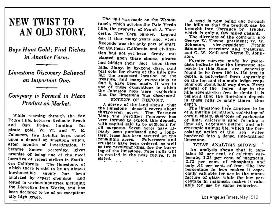
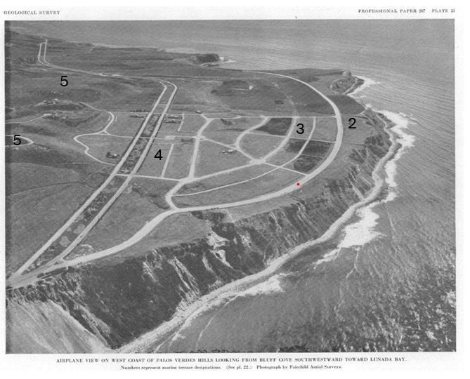
Two Lomita boys, hunting for pirate gold, came upon a deposit of limestone (Figure 4.1), which, after months of investigation, gave promise of being one of the most lucrative strikes in Southern California. The find was made on the Weston Ranch, which adjoined the Palos Verdes hills (Figure 4.2), the property of Frank Vanderlip, the founder of Citibank and co-creator of the Federal Reserve.[4]
The Torrance Lime and Fertilizer Company was formed in 1919 to exploit this deposit. Pulverizers and crushers were ordered, as well as two revolving kilns. A road was cut through the hills so that the product could be brought into Torrance by trucks. The directors of the company were George Towne, President, W. Johnston, vice-president, with Frank Sammons as secretary and treasurer. A decision was made in November 1921 to develop the
company as rapidly as possible. They also decided to change the name from the TL&FC to the Decomposed Marine Shell and Bone Company, DMS&B, with these initials as trademark.
The company later opened a second quarry in Lomita, as described in an old Californian mining journal:
Lomita (southwest of), Los Angeles County, California – Palos Verdes Limestone Deposit (Algal Limestone)…… limestone was produced for 3 years 1927-29 inclusive, by Torrance Lime and Fertilizer Company. It was used primarily by Pioneer Compost Company and also by citrus fruit growers on adobe soils…..These fossil beds are reported to be 30 feet thick and are covered by 12 feet of adobe soils. They are probably Quaternary (Pliocene).
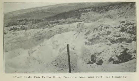
The quarry mined fossiliferous Pleistocene marl and limestone, dipping to the northwest. Nodules of phosphorite were present in the marl, making the deposit suitable as a fertilizer. The open pit was 300 feet long, 200 feet wide and 60 feet high (Figure 4.3) and mined with a dragline scraper, with the production crushed in a 100-ton plant on the property. The location of the quarry was listed as being on the East Slope of Palos Verdes Hills (Sec. 34, T. 4 S, R. 14 W), about 1 mile southwest of Lomita.[6] The Lomita Quarry (Figure 4.4) yielded many fossils, mostly invertebrates, but was outshone by the original Torrance Lime and Fertilizer Company. Its numerous fossils were alleged to make it the world’s best fertilizer (see section 6).
10 RESERVOIR ISSUE 2 • MAR/APR 2024
FIGURE 4.1 Story of the discovery of the Torrance Lime and Fertilizer deposit, Los
RESERVOIR ISSUE 2 • MAR/APR 2024 11
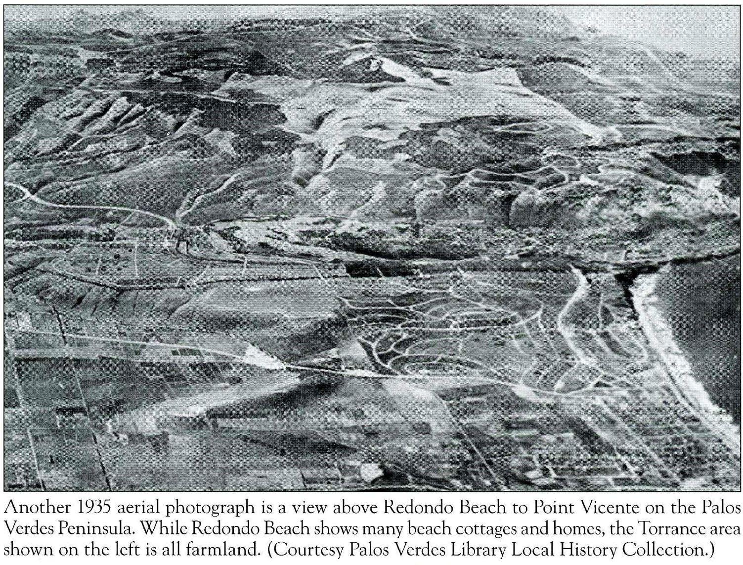
FIGURE 4.2 Aerial photograph above Redondo Beach, Palos Verdes Hills in the distance, 1935 (Palos Verdes Library).
FIGURE 4.3 Photograph of the fossil beds at Lomita Quarry, 1927.
5. THE COLOUR PURPLE
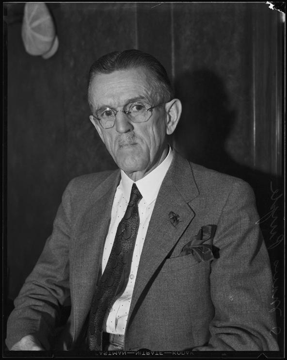
By 1921, the makeup of the board had evolved, with Frank Sammons promoted to President, Richard. C. Kite as secretary and Samuel Maus Purple (Figure 5.1) hired as General Manager in March 1921. Purple was born in 1878 in Pennsylvania. His profession was listed as an archaeologist, but census records [10] indicate that he was always a salesman, so maybe he embellished the truth a little. He even wrote an extended article on sales techniques in the Torrance Enterprise in June 1921. He focused on patient, persistent effort, putting the customer at ease, acquiring an education and energy.
As we will see, he was also an obsessive amateur palaeontologist (Figure 5.1), a penchant that
came to the fore in his job at The Torrance Lime and Fertilizer Company. Later in his career he kept up an interest in geology, discovering a large, steaming, volcanic crater (Figure 5.2) near Santa Paula, CA, in 1930.[11,12] He and his wife had two daughters and eventually retired to Monterey, where he died in 1965.[10] His wife donated his scientific papers to the National Library of Medicine (U.S.) in 1967 and his fossil collection to the Municipal Museum of Riverside, California, in 1968.
S. Maus Purple brought every ounce of his expertise to bear when it came to getting the most out of the mine. He immediately recognized that the fossil component of the excavated material could be used to advertise
6. ADVERTISING – A PURPLE PATCH
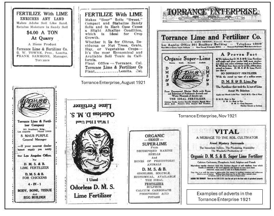
The two “Life Extension Bulletins” presented to quarry visitors by Purple, together with adverts sprinkled through local newspapers (Figure 6.1), did not hold back when singing the praises of their fertilizer:
D.M.S. Lime will singly and alone render land more productive than any other substance used as a fertilizer
…unless more lime is put into the soil, stronglimbed athletes cannot be developed in this country…
Our Heavenly Father in His supreme wisdom has placed this vast deposit of ancient marine shell lime at the very gates of the centre of one the
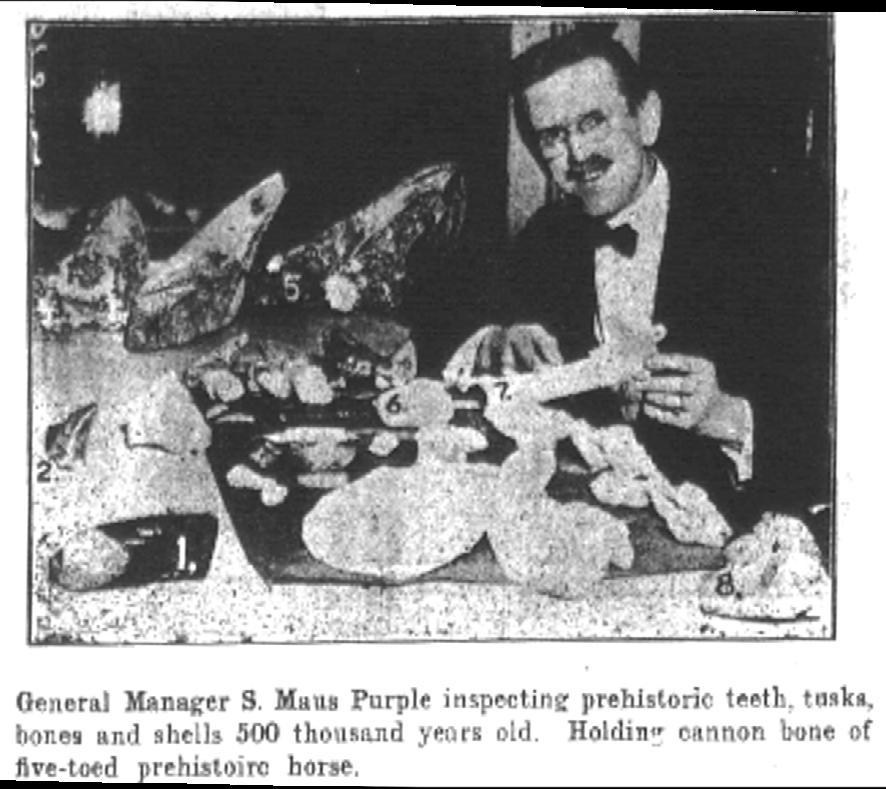
of fossils from the Torrance Lime and Fertilizer quarry, 1921, Torrance Herald.
the product and invited many scientific experts to visit the mine to share their expertise. Based on their input, Purple wrote and disseminated numerous stories in the press (faithfully reported in the Torrance Herald and Torrance Enterprise newspapers) as well as handing out editions of the “Life Extension Bulletin”, a privately financed newssheet, to visitors to the mine. These included advertisements, testimonials, letters from scientists, geochemical reports and geological stories aplenty. They certainly make for entertaining reading, more than one hundred years later, and at the time the company must have been one of the largest in Torrance, the burgeoning city.
Purple in the field near Santa Paula, CA, in 1930.
greatest agricultural districts of the universe….. Use D.M.S. Lime and stimulate your faith!
“I used about three tons of D.M.S. to less than one half acre of ground, which was very hard adobe. The D.M.S. absolutely turned the adobe into an aerated broken up soil, on which I grew the largest and best crop of melons” (J.E. Chandler)
It makes the crops grow and the ranchers crow.
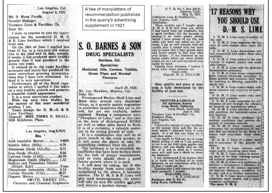
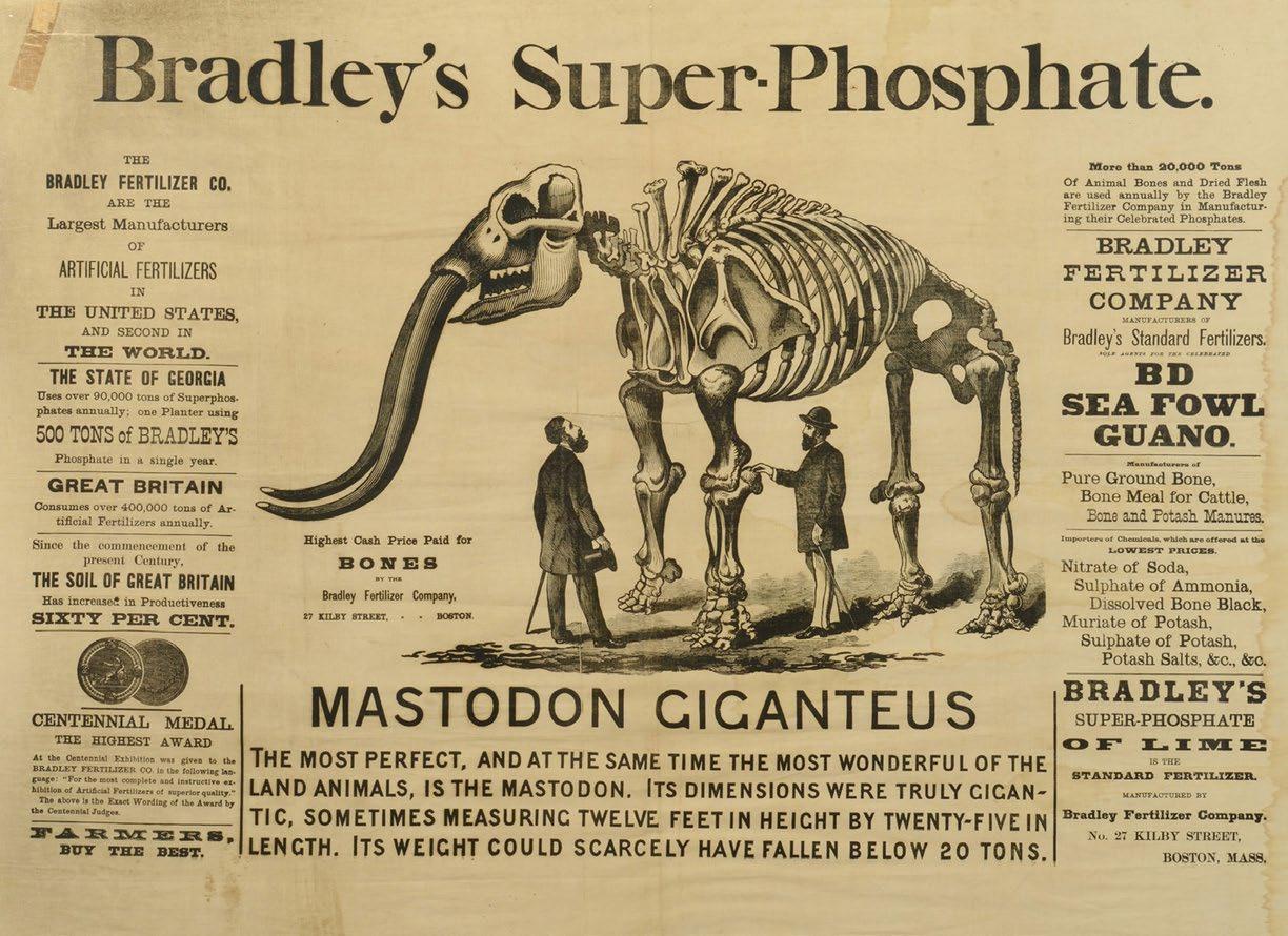
The papers also published many testimonials from satisfied customers (Figure 6.2), along with details on the analysis of the bedrock. Reading through some of this material, mostly drawn from the Torrance Enterprise newspaper, seems
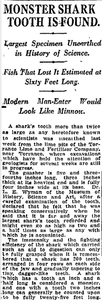
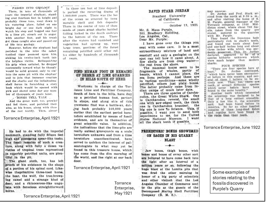
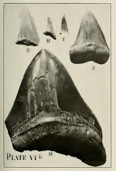
like overkill, but other fertilizer companies were up to the same tricks (Figure 6.3). Purple also pushed stories about the fossils (as we shall see below), and some of the finds at the company quarries made their own headlines: “Monster Shark Tooth is Found – Largest Specimen Unearthed in History” (Figure 6.4).
One unusual decision made by the Company was the rebranding of the Torrance Lime and Fertilizer Company to the Decomposed Marine Shell and Bone (DMS & B). It hardly seems a very catchy title but is proudly displayed on every advert (Figure 6.1) and even on the original envelope (Figure 2.1).
12 RESERVOIR ISSUE 2 • MAR/APR 2024
FIGURE 5.1 Purple with a variety
FIGURE 5.2
RESERVOIR ISSUE 2 • MAR/APR 2024 13
FIGURE 6.1 A variety of advertisements for the Torrance Lime and Fertilizer Company, published in the Torrance Enterprise newspaper in 1921.
FIGURE 6.2 A few of many letters of recommendation published in the Life Extension Bulletin, a printed handout given to visitors to the Torrance Lime and Fertilizer quarry, 1921.
7. PURPLE AND THE ACADEMICS
In May 1921, Purple invited over one hundred distinguished visitors to visit the DMS&B lime deposits of the TL&FC south of Lomita (Figure 7.1). After examining the different formations that had been exposed, luncheon was taken, and several “shots” put off that were real blasts. Many interesting discoveries were made after the blasting, including jaw bones, thigh bones and wish bones. Most exciting was the tooth of a sabre tooth cat, fully 5.5 inches in length. There were three shots made, the third one being quite disastrous, throwing a large boulder over onto the office building and puncturing the roof. No one was hit, however. As mentioned earlier, Purple also distributed a unique and well-edited newspaper entitled “Life Extension Bulletin”.
Purple clearly spent significant amounts of time looking for fossils. He put many on show at the quarry and in the window of Lee’s Grocery Store, advertised under the title “Fertilizing with Fossils” and published a map to help visitors find their way to them (Figure 7.1). Exhibits included “teeth, vertebrae, feet and
toes”. Maus sent specimens to several experts in the southwestern US, one of whom was Professor David Starr Jordan. He wrote back, describing the fossils as “a most extraordinary mixture of land and sea stuff”. “The mammal bones seem to be fragments of whales and… sea lions, perhaps”. He was particularly excited by the shark teeth: “The two large shark’s teeth are especially valuable because they are different from any that we have ever received and the species, one of the great white sharks, seems to be new to science. The fish must have been nearly 100 feet long”. He eventually identified at least four species of Carcharodon, the great white shark, and several other shark species. He eventually named one of the new species of Carcharodon after Purple.
David Starr Jordan was a New York native who received both medical and doctorate degrees in Indianapolis, helped to name more than 2,500 species of fish and served as the founding president of Stanford University. His support of eugenics led to the removal of his name from several buildings.
Ernest Locke (geologist) wrote to Purple to say “I am of the opinion, judging from a short visit to your property, that your deposit was formed near the mouth of a river emptying into the ocean, in the shallow brackish waters of which lived and died the organisms whose shells in incredible numbers accumulated for centuries and centuries…..the deposit apparently belongs to the Tertiary period, judging from the fauna remains and especially from the immense shark’s teeth discovered there”.
Other visitors included Dr. Milbank Johnson, president of the Southwest Museum, and a staff of scientists. Purple had agreed for the museum to take over all the fossil remains, while the museum would be ready to rush trained excavators to the scene whenever particularly promising remains were brought to light. Professor Chester Stark, an eminent geologist, and Dr Wyman of the Museum of History, Science and Art, also visited, the latter marvelling at a 4.5 inch long shark tooth: “far and away the largest shark’s tooth recorded”.
14 RESERVOIR ISSUE 2 • MAR/APR 2024
FIGURE 6.3 Competing advertisement for Bradley’s Super Phosphate fertilizer, cloth advertisement from Boston, 1881.
FIGURE 6.4 News story about the Great White shark teeth found at the Torrance Lime and Fertilizer quarry, Los Angeles Times 1921.
8. GEOLOGY
The geology of the area was described by Professor Ellis Bailey, Professor of Geology at the University of Southern California in 1922 (Table 1). Those containing significant fossils in the Torrance Lime and Fertilizer Pit are highlighted in yellow. The company’s lime deposit is on the edge of the fault line, which occurs at the base of the hills from Redondo to San Pedro and is about 250 feet above sea level. The origin of this vast deposit of decomposed marine shells is an accumulation
of shell fragments and foraminiferal cases on the ocean bottom.
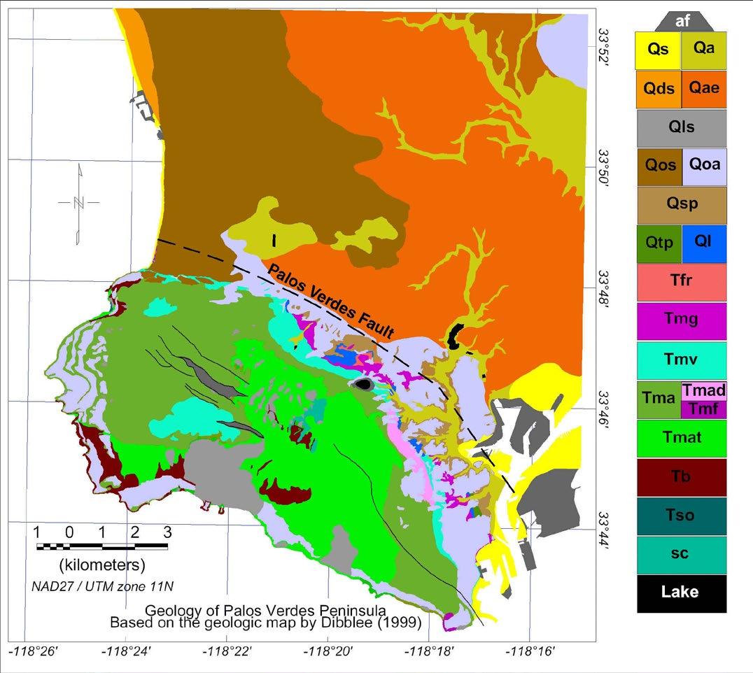
Bailey’s interpretation, published in the company’s Life Extension Bulletin in 1922, fits closely with modern ideas (Fig 8.1; 8.2). An island (“Palos Verdes Island”) was formed by uplift, perhaps 1 million years ago.[16,17] The island was cored by the Altamira Shale. Continuing changes in relative sea level created at least 13 terraces at different
elevations (Figures 8.3; 8.4), on which mainly shallow marine deposits were laid down.[17,18] The stratigraphy is often complex due to repeated downcutting and deposition as well as relative sea level changes (Figure 8.3). The Palos Verdes sand was deposited around the island and some distance beyond. Sedimentation was influenced by the ongoing subduction of the Pacific Plate, leading to significant tectonic deformation, and localized angular unconformities are common.
RESERVOIR ISSUE 2 • MAR/APR 2024 15
FIGURE 7.1 Details of invitations to scientists and the public to visit the company quarry, published in the Life Extension Bulletin, a printed handout given to visitors.
16 RESERVOIR ISSUE 2 • MAR/APR 2024
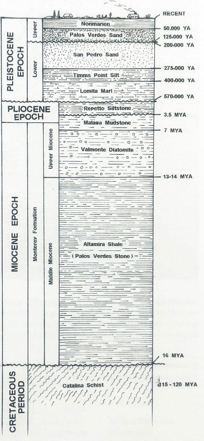
FIGURE 8.1 Stratigraphic column taken from Joe Cocke’s excellent book Fossils of the Palos Verdes Hills, 2015.
FIGURE 8.2 Geological map of Palos Verdes Peninsula, USGS, after a map by Dibblee 1999.
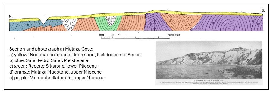
FIGURE 8.3 Cross-section of typical terrace morphology, from Woodring et al 1946.
Age Formation
Recent Strand Fm.
Depositional setting
Terrace Epoch – raised beaches dating from Inter-Glacial to after the San Pedro epoch. The terraces are wave-cut with marine gravels and are cut by later gullies eroded into them. Some contain middens including mounds of seashells and bones of land animals as well as charcoal and arrow heads. Unconformity at the base. (Terrace Epoch is equivalent to the Palos Verdes Sand)
Pleistocene
Pleistocene
San Pedro Epoch
The Upper San Pedro was laid down in 50 fathoms of water with an abundant warm water marine fauna.
Soft sandstone and marls, the ocean encroached upon the edge of the land. Valleys were filled with gravel, and the plains covered with sands and other sediments. The Lower San Pedro (Deadman’s Island Beds) has a cold water fauna including bones of whales, sea lions, shark’s teeth, sea shells.
Underlain by the Lomita Marl and Timms Point Silt (common molluscs). Terraces began forming around 1 million years ago, when the Palos Verdes area was an island.
Sierra Epoch Uplift with the great height of the Sierras bringing glaciers. There were two glacial periods with an inter-glacial when mankind and the Rancho La Brea animals appeared. Limited fossils. (Uplift may have happened up to 40 MYA)
Pliocene San Diego Fm. Red and yellow sandstone, laid down in water about 100 fathoms deep (equivalent to the deeper water Repetto Siltstone).
Miocene Monterey Fm. (now called the Altamira Shale or Palos Verdes Stone)
During the Miocene this low island sunk to a depth of 500 fathoms beneath the waves, and the sediments were deposited. These contain the petroleum of the Los Angeles oil fields. Just after the Monterey sediments were laid down the rocks were folded, faulted, forming the Coast Range. The Monterey rocks were intruded by a diabase found near the summit of the San Pedro Hills. (Fossils similar to modern fauna but with much smaller whales; the most common fossils are herring, mainly scales. The shales are overlain by the Valmonte Diatomite, formerly mined, and the Malaga Mudstone).
Cretaceous to Eocene Basement elevated to form a low island, with no deposition
Jurassic Franciscan Fm. Shales, glaucophane schists, igneous rock, metamorphosed Pacific Plate (now thought to be around 120 MYA)
RESERVOIR ISSUE 2 • MAR/APR 2024 17
TABLE 1. Stratigraphy and palaeontology at the DMS&B marl pits according to Professor Ellis Bailey. My comments from other references in italics.
FIGURE 8.4 Photograph showing terraces close to Palos Verdes Hills, from Woodring et al 1946.
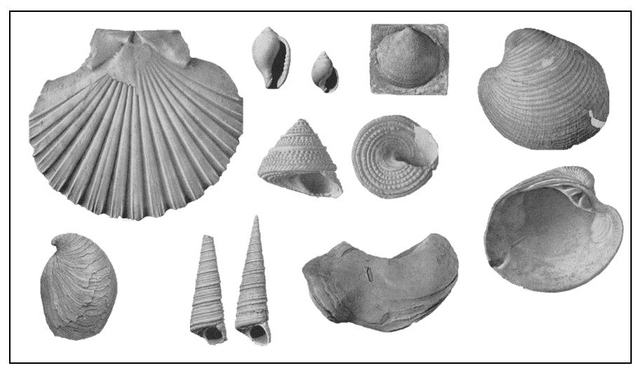
9. PALAEONTOLOGY
Most of the Pleistocene-age land animals found in the La Brea Tar Pits have also been found as fossils in the Palos Verdes Hills.[18] Terrestrial animals swam across the island and their remains were sometimes incorporated into the terrace deposits. Fossil invertebrates were so common that thousands of complete shells have been collected. Scientific collections of fossils from the area date back to 1903, when Arnold published a book on the paleontology and stratigraphy of the Plio-Pleistocene of San Pedro.[22] Today only a few Plio-Pleistocene sites remain, but there are many Miocene deposits of the Altimira Shale still accessible by fossil hunters.[18] Only a few of the many quarries formerly worked in the region remain undeveloped.
Several technical papers have been published on the fossils yielded by the quarry,[18,19,20,21] but the newspapers of the time provided much more graphic descriptions (Figure 9.1):
“World’s Greatest Fossil Bed at Palos Verdes” (San Pedro News Pilot 1923)
They went back 1,000,000 years yesterday in digging down ten feet on the property of the Torrance Lime and Fertilizer Company at their quarries on the O.S. Weston Ranch South of Lomita…. Scientists spent the morning examining and appraising the various bone, shell and rock specimens as they came up in… excavations which promise to be among the most important in Southern California (1921).
Although solely for commercial purposes… the excavations have produced fossils from 5 to 1 million years before this era and have also yielded a portion of an immense pelvic bone…… In those ten feet of lime deposits is packed the recurring drama of 1,000,000 years…. Great sharks battled….large trees the Imperial elephant…the sabre toothed tiger pounced upon him, sinking his 12 inch teeth into the helpless victim…. And almost yesterday, it seems, a famished and desperate man…tunnelled several yards, using a clumsy, heavy shale, scraper to the source of a stream….. They found traces of him today, a few bones mixed with those of the shark, the teeth of a wolf (April 1921).
18 RESERVOIR ISSUE 2 • MAR/APR 2024
FIGURE 9.1 Some fossil stories about fossil discoveries in the Torrance Lime and Fertilizer quarry, from the Torrance Enterprise, 1921.
Workmen in charge of the TL&FC…have dug up a human foot, perfect in shape, and alongside of this grewsome find was a battle-ax… the foot rests on its outer side and it is exceptionally long …. In addition to the “near-foot” and the human weapon there are bones… that ape-like man was in tropical surroundings and luxuriant foliage…He had to do with the imperial mammoth, standing fully 15 feet high and possessing spear-like tusks. The fossil remains of such a creature…are plentiful in the pit. The giant sloth… the primitive three-toed horse, the bear, the wolf, the tree-browsing camel and a strange kind of deer, and a rhinoceros-like ungulate with ferocious straightforward horns. But most terrifying of all, perhaps, was the saber-toothed tiger…having teeth some fifteen inches long…(1921).
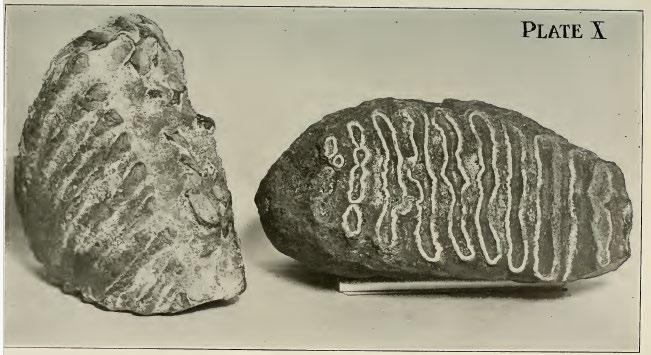
Starr mentioned that a few of the shells were from deep water, the rest from the shoreline (Figure 9.2).[20] There were bones of whales and (probable) sea lions. There were four species of Carcharodon (Figure 4.3), the Great White Shark and several other shark and ray species (more than 100 teeth in all). There were also sea lion teeth, tusks and bird bones. Land mammals included paws of a bear, vertebrae of a giant sloth, bones of a great wolf and of a lion, the nasal bone and teeth of an imperial elephant (which “weighed 6 ¾ pounds and measures 8 ½ inches across the chewing surface”: Figure 9.4), the tusk of the saber tooth tiger and a hippopotamus and bones of the five toed horse. One important discovery was the tooth of a prehistoric crocodile (An “animated leather lizard…the first found west of the Nile”). Other authors have reported the tusks of mastodons (Figure 9.4) and the remains of several fossil whales over the years, including a 2 million year old whale from the Palos Verdes Hills, near Lomita, found in 1921.[18]
10. SUMMARY
Without a doubt the gift of a simple envelope sent me down a fascinating geological rabbit hole. It also served to demonstrate the amazing resources that are out there for the intrepid researcher. Genealogical records, the census, newspaper archives and technical published papers can be used to paint an incredibly detailed picture of life in the 1920s (I have skipped a lot of the mundane stories from the Torrance Herald and Enterprise newspapers but feel free to explore the 1920s newspapers further[9]). Added to this was a really interesting geological story that provides direct analogues to Cretaceous sedimentary deposits of the Western Interior Seaway, along with the chance to explore a “La Brea” fossil fauna preserved in a completely different depositional setting. Finally, I salute the maverick S. Maus Purple, who showed that even the most amateur of geologists can have their day in the limelight, and end up having a species of Great White Shark named after them.
RESERVOIR ISSUE 2 • MAR/APR 2024 19
FIGURE 9.2 A selection of molluscs from the Palos Verdes Hills, Starr Jordan 1921.
FIGURE 9.3 Great White Shark teeth from the Torrance Lime and Fertilizer quarry, Starr Jordan 1921.
FIGURE 9.5 Imperial elephant (mastodon) teeth from the Torrance Lime and Fertilizer quarry, Starr Jordan 1921. The mastodon tusk is from the Torrance area 1921.
SELECTED REFERENCES
1 Scott, W. Berryman. 1913. A History of Land Mammals in the Western Hemisphere. Book, Author: Blair Professor of Geology and Paleontology in Princeton University. New York, The Macmillan Company, 1913. Pp. 693, with frontispiece and 304 text-figures.
2 https://www.extremeweatherwatch.com/ cities/los-angeles/year-1922
3 www.quarriesandbeyond.org
4 “Limestone in California” by Clarence. A. Logan, California Journal of Mines and Geology, Vol. 43, no. 3, July 1947, California Division of Mines, San Francisco, California, pp. 175-357.
5 https://scvhistory.com/scvhistory/files/ miningincalif1927/files/basic-html/page387. html
6 Mines and Mineral Deposits of Los Angeles County, by Thomas E. Grey, Jr., Assistant Mining Geologist, California Division of Mines, California Journal of Mines and Geology, vol. 50, nos. 3 and 4, July-October 1954, pp. 467-709.
7 www.mindat.org/paleo_loc.php
8 https://maureenmegowan.com/south-bayhistory/torrance-history/
9 https://libarch.torranceca.gov/ archivednewspapers
10 https://www.ancestry.com/1940-census/ usa/California/S-Maus-Purple_2l7d01
11 https://dl.library.ucla.edu/islandora/ object/edu.ucla.library.specialCollections. bartlett:1270
12 https://calisphere.org/item/ark:/21198/ zz002bx2x8/
13 https://books.google.ca/books?id=Ks6_AAA AIAAJ&printsec=frontcover#v=onepage&q&f =false
14 Adelbert Bartlett Papers, Department of Special Collections, Charles E. Young Research Library, UCLA (permission granted to UC Regents to share on the web)
15 The Giganotosaurus, Disinterred From Rocks, 1912. From A Reconstruction Drawing By A. Forrestier, From The Book The Outline Of History By H. G. Wells Volume 1, Published 1920
16 Dibblee, T.W., Ehrenspeck, H.E., Ehlig, P.L., and Bartlett, W.L. 1999. Geologic map of the Palos Verdes Peninsula and vicinity, Redondo Beach, Torrance, and San Pedro quadrangles, Los Angeles County, California. Dibblee Foundation Map DF-70.
17 Woodring, W.P., M. N. Bramlette, and W.S.W. Kew. 1946. Geology and paleontology of Palos Verdes Hills, California. USGS Professional Paper 207.
18 Cocke, J. 2015. Fossils of the Palos Verdes Hills. Published by Lamna Publishing.
19 Caputo, M.V. 2007. Late Pleistocene marine Paleoenvironments of two molluscan biosomes, eastern Palos Verdes Peninsula, California. In book: Geology and Paleontology of Palos Verdes Hills, California - A 60th Anniversary Revisit to Commemorate the 1946 Publication of U. S. Geological Survey Professional Paper 207 (pp.121-142). Publisher: Pacific Section SEPM (Society for Sedimentary Geology) Editors: Brown, A. R., Shlemon, R. J., and Cooper, J. D.
20 Coan, E.V. 1984. The Recent Crassatellinae of the eastern Pacific, with some notes on Crassinella. Veliger -Berkeley- 26(3):153-169.
21 Jordan, David Starr. 1922. Sharks Teeth From California. The American Journal of Science.
22 Arnold, R. 1903. The Paleontology and Stratigraphy of the Marine Pliocene and Pleistocene of San Pedro, California. Volume 31 Of Contributions To Biology From The Hopkins Seaside Laboratory.
https://www.torrancehistoricalsociety.org/ research/records.html

20 RESERVOIR ISSUE 2 • MAR/APR 2024
RESERVOIR ISSUE 2 • MAR/APR 2024 21
2024 UPCOMING EVENTS INFORMATION
MARCH
March 6th
Wednesday | 12:00 - 1:00 pm MST
International Technical Division
ReconAfrica Exploration in Onshore Namibia
Speaker: Scott Gardiner
Location: CEGA Conference Room, +15 level, 540-5 Ave SW, Calgary AB
March 6th
Wednesday | 5:30 – 7:00 pm 2024 Student Resume and Interview Workshop
Location: University of Calgary, Room ES136, 844 Campus Place NW, Calgary, AB
March 9th
Introduction to Petrophysics
Saturday | 9:00 am – 3:00 pm MST
Location: Mount Royal University, Room B206, 4825 Mt Royal Gate SW, Calgary, AB
March 13th Online Only
Wednesday | 12:00 - 1:00pm MST
E.T.S Technical Division
The Role of the Subsurface in Future Low Carbon Intensity Hydrogen Value Chains
Speaker: Mark W. Shuster, Interim Director, Bureau of Economic Geology, UT Austin
March 14th-16th
Thursday-Saturday
39th Annual Squash Tournament
Location: Bow Valley Club, Calgary AB

March 16th
Saturday
PALEO 2024
Location: Mount Royal University, Room B108, 4825 Mt Royal Gate SW, Calgary, AB
March 20th Online + In Person
Wednesday | 12:00 - 1:00 pm MST
B.A.S.S. Technical Division
Hi-Res Seq. Strat. analysis and depositional environ. reinterpretation of the JurassicCretaceous Fortune Bay & Hibernia formations in the Jeanne d’Arc Basin
Speaker: Wen Lin, Suncor
Location: CEGA Conference Room, +15 level, 540-5 Ave SW, Calgary AB
March 21st Online + In Person
Thursday | 12:00 - 1:00 pm MST
GeoWomen
Road Tripping Through South Korea –Highlights of a Female Geo's Solo Travels
Speaker: Katey Roberts, P.Geo. Senior Geologist, Ember Resources
Location: CEGA Conference room, +15 level, 540-5 ave SW, Calgary AB
March 27th Online Only
Wednesday | 12:00 - 1:00 pm MST
Geothermal Technical Division
Multi-disciplinary Investigation into the Geothermal Energy Potential of the East Shore of Kootenay Lake, BC
Speaker: Gord MacMahon, BSc, MA, PGeol
22 RESERVOIR ISSUE 2 • MAR/APR 2024
2024 UPCOMING EVENTS INFORMATION
APRIL
April 3rd Online Only
Wednesday | 11:00 am – 12:00 pm MST
Structural Geology Technical Division
Quaternary Tectonics of the Rocky Mountain - Tintina Trench
Speaker: Theron Finley, PhD Candidate, School of Earth and Ocean Science, University of Victoria, BC
April 16th
Tuesday | 11:30 am - 1:00 pm MST
Technical Luncheon
Depositional, stratigraphic and structural controls on the geometry of Montney
Formation reservoirs: Lower Triassic, northeast British Columbia, northwest Alberta
Speaker: Peter Proverbs, Tourmaline Oil
Location: Calgary Petroleum Club, Devonian Room 319 5 Ave SW, Calgary, AB T2P 0L5
April 17th
Wednesday | 12:00 - 1:00 pm MST
International Technical Division
Deepwater Exploration History of the Sabah Trough, Malaysia- Interplay between Depositional Systems, Structure, and MassTransport Complexes
Speaker: Nick Wilson, Gran Tierra Energy
Location: CEGA Conference room, +15 level, 540-5 Ave SW, Calgary AB
This talk will be in-person only
April 24th
Online + In Person
Wednesday | 12:00 - 1:00 pm MST
E.T.S Technical Division
Highlights of the Northeast BC Geological Carbon Capture and Storage Atlas
Speaker: Natalie Sweet
Location: CEGA Conference room, +15 level, 540 - 5 Ave SW, Calgary AB

RESERVOIR ISSUE 2 • MAR/APR 2024 23
THE WORLD’S OLDEST OILFIELD: THE WITWATERSRAND OF WELKOM, SOUTH AFRICA
ABSTRACT
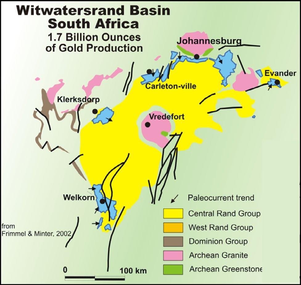
The Witwatersrand Basin hosts the world’s largest gold province in placer deposits dating to around 2.9 billion years old. The gold is typically hosted in conglomeratic layers ranging from a few centimetres to several metres in thickness, set in a quartzite matrix. Subsidiary minerals include pyrite, uranium, gold and carbon stringers. The sediments are interpreted to have been deposited in braided rivers and alluvial fans, with possible marine influence. Sedimentary structures including cross-bedding, basal scours and ripples support this interpretation.
A high-resolution data set has been collected from the Leader Reef Zone of the Witwatersrand Supergroup, exposed close to one kilometre underground at St. Helena Gold Mine, in Welkom, South Africa. A total of 156 sections, ranging from less than 1 m to around 3 m in thickness, were measured through this stratigraphic horizon. The sections were spaced at intervals of around 5 m, and the dimensions of the entire study area were around 150 m by 150 m. Lithofacies identified within the Leader Reef consisted of conglomerates, quartzites with scattered pebbles and pure quartzites, subdivided into a lower channelised unit and an upper sheetlike unit. The interpreted environment of deposition of the two units is a braided river deposit overlain by a transgressive fluvial lag deposit. Samples were also collected and assayed for gold every few centimetres of each logged section.
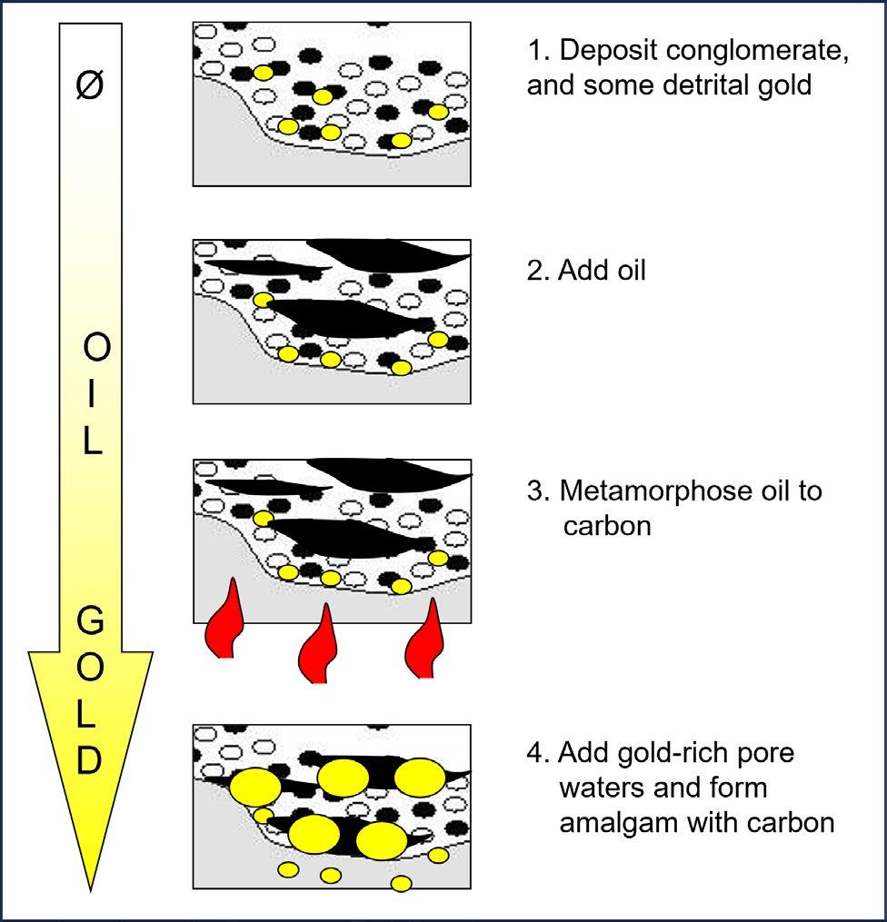
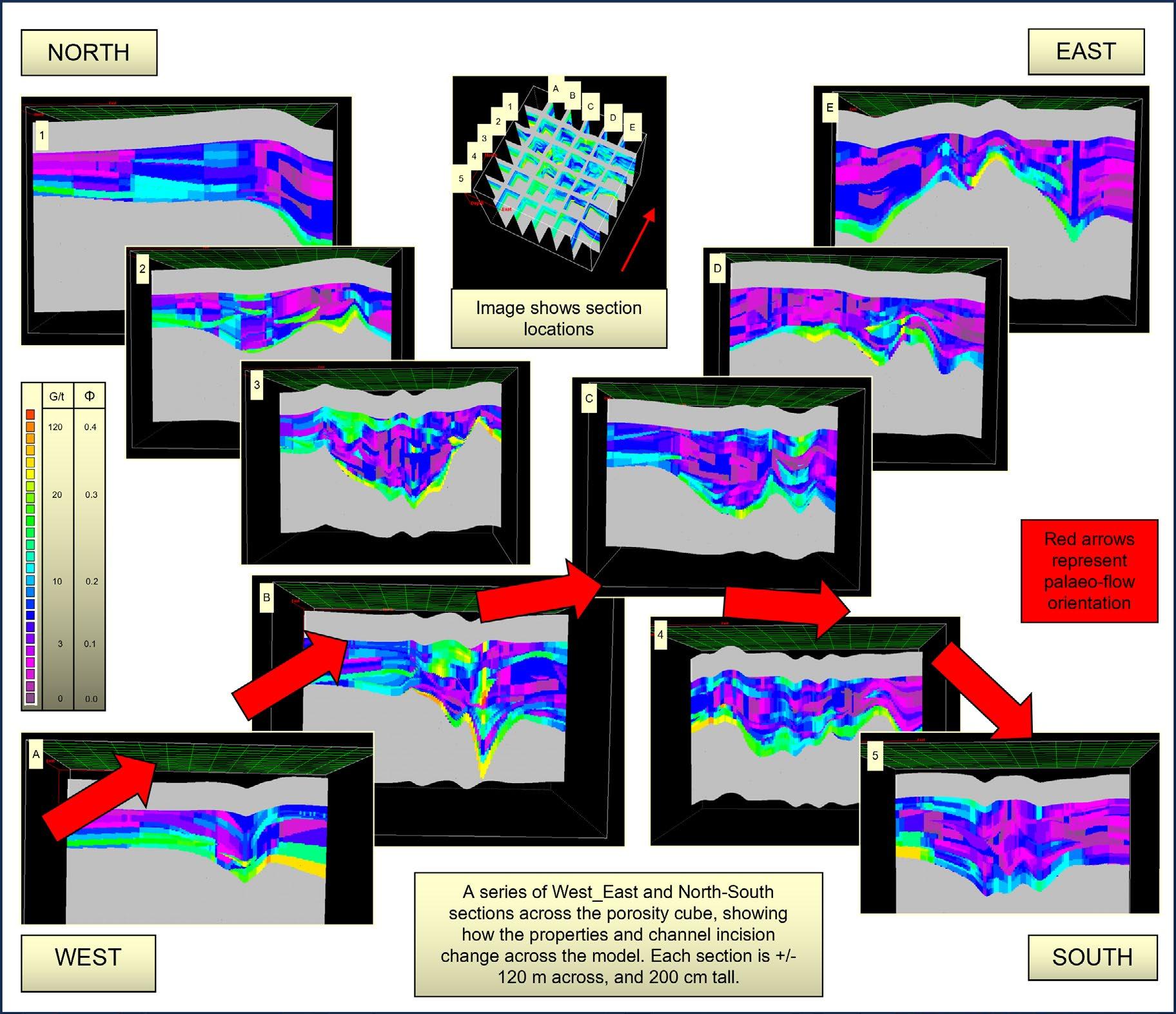
The data has been used to construct a three-dimensional computer model, allowing the distribution of gold and facies to be interpolated throughout the model. A depositional model assumes primary placer deposition in rivers populated by primitive algae. Early diagenesis and catagenesis transformed the algal remains into hydrocarbons that migrated into pore spaces, later undergoing metagenesis at high temperatures and pressures that converted the hydrocarbons into carbon. This carbon provided a nucleus for remobilized gold ions, transported in hydrothermal fluids, to form an amalgam that deposited pure gold. The more primary porosity -> the more hydrocarbons -> making more carbon -> depositing more gold, hence gold concentration is a proxy for porosity.
STUDY LOCATION
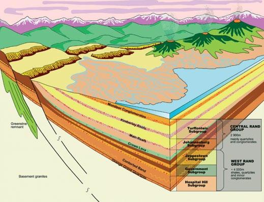
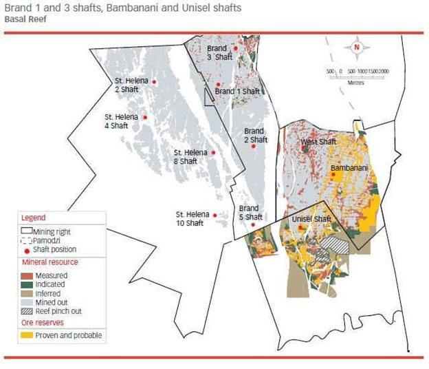
The Free State Goldfield lies at the southern edge of the Witwatersrand Basin (Figure 1), located near the towns of Virginia and Welkom in South Africa. The town is underlain by Permian Karoo Supergroup sediments and Klipriviersberg Group volcanic rocks, which in turn are underlain by the Central Rand Group that hosts the gold-bearing conglomerates. Structurally, the Free State Goldfield lies within a north-south trending syncline forming an apex in the south-western corner of the Witwatersrand Basin. The principal reefs (gold-bearing
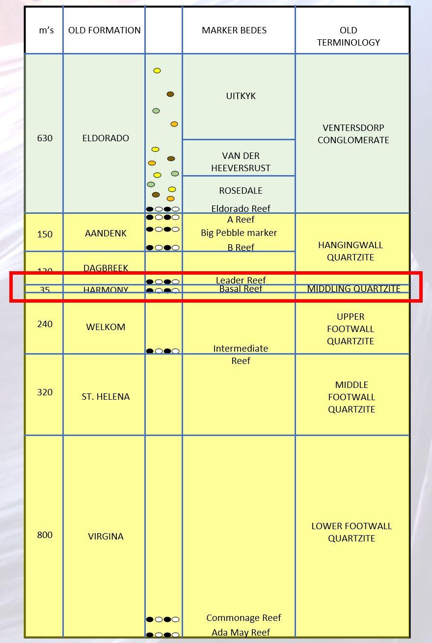
conglomeratic intervals) mined in the Goldfield are the Basal Reef, the Saaiplaas or Middle Reef, the Leader Reef, the B Reef, the A Reef, Elsburg and Dreyerskuil Reefs (Figure 2).
St. Helena Gold Mine (Figure 3) is located on the southwestern margin of the city of Welkom and mining focuses on the Basal Reef and overlying Leader Reef. The two orebodies dip at around 20 degrees and are separated by 15 m of Middling Quartzite (Figure 4). The orebodies are cut by numerous normal and reverse faults including the 500 m Dagbreek Fault, running through the middle of the mine, which has both orebodies dragged along the fault plane. The fault is crossed using
24 RESERVOIR ISSUE 2 • MAR/APR 2024
Jon Noad, Stantec Consulting; University of Adelaide
underground trains to reduce walking times underground. Five major shafts provide access to the subsurface, with the Basal Reef sitting up to 2 km below surface. At one time more than 30,000 workers a day would go underground. The mine is no longer operational.
GEOLOGY AND SEDIMENTOLOGY
The Witwatersrand Plateau consists of a 5000 to 7000 metre-thick layer of mainly sedimentary rocks (the Witwatersrand Supergroup) laid down over 260 million years, beginning around 3 billion years ago. Gold is found in the conglomeratic strata of the younger members of the Supergroup and over 40,000 tonnes of gold have been mined from these rocks, some 22% of all gold mined on Earth. A massive meteor impact around 2 billion years ago created a 300 km diameter crater, distorting all the rock strata within that circle. The ridge around the rim of the crater brings gold bearing rocks of the Witwatersrand Basin close to the surface in some areas, while they remained more deeply buried in other areas, such as around Welkom, in the Free State, the location of the St. Helena Gold Mine.
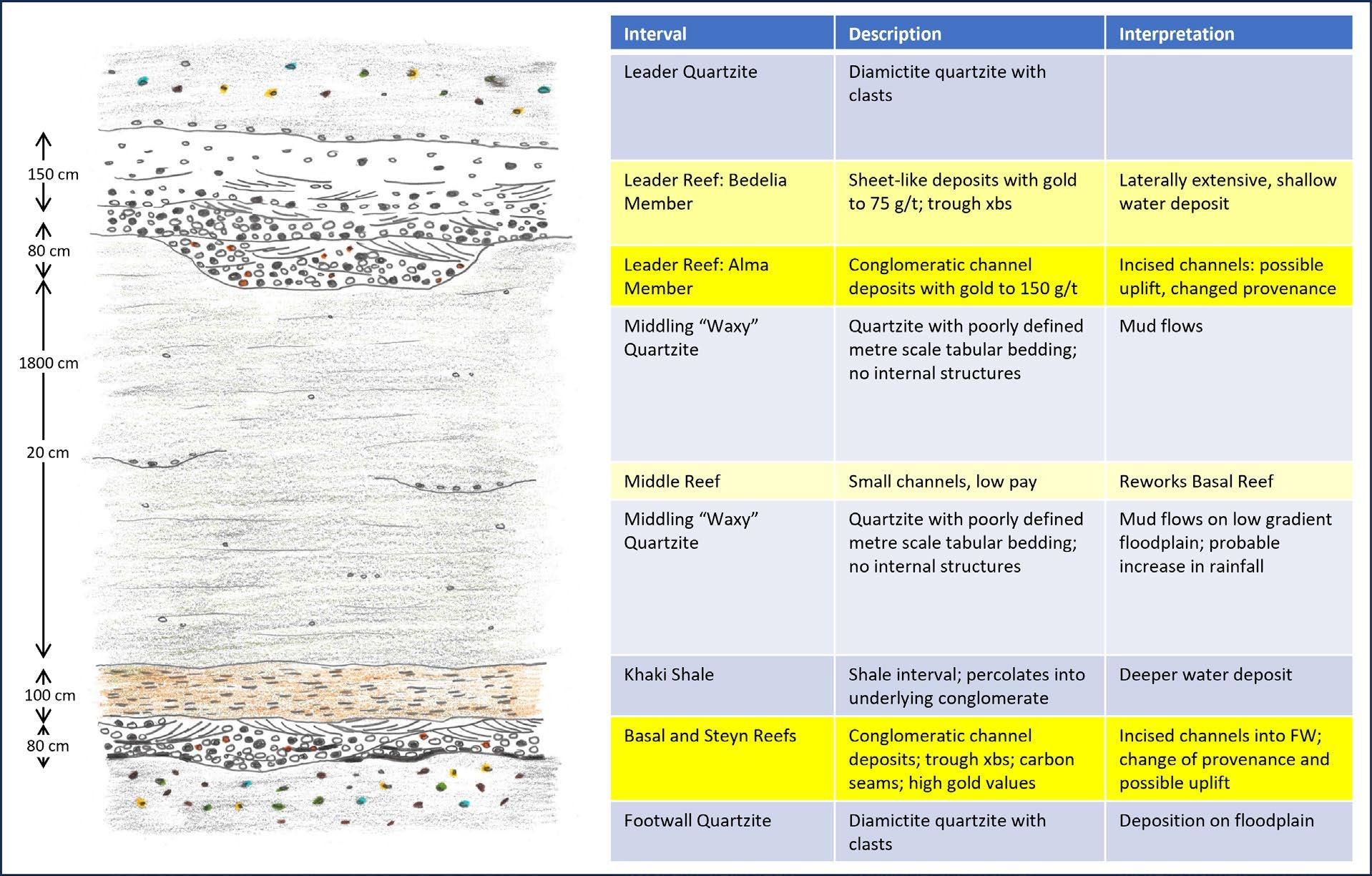
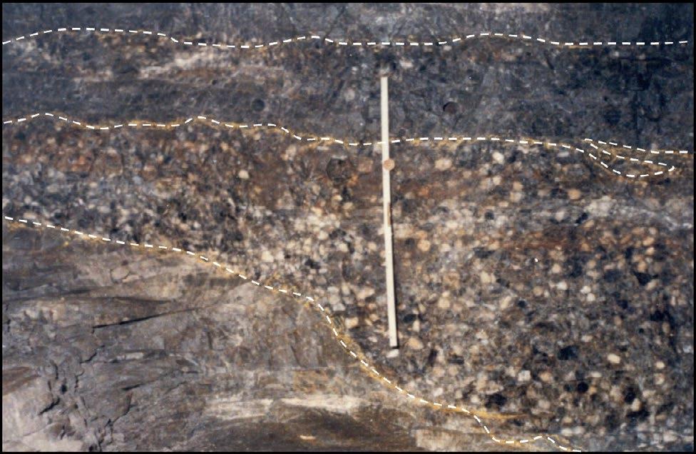
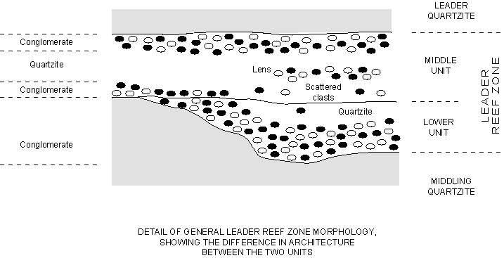
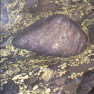
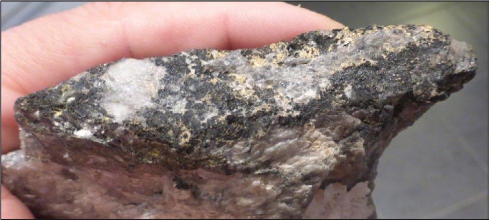
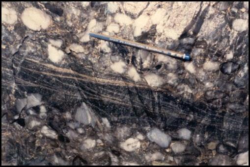
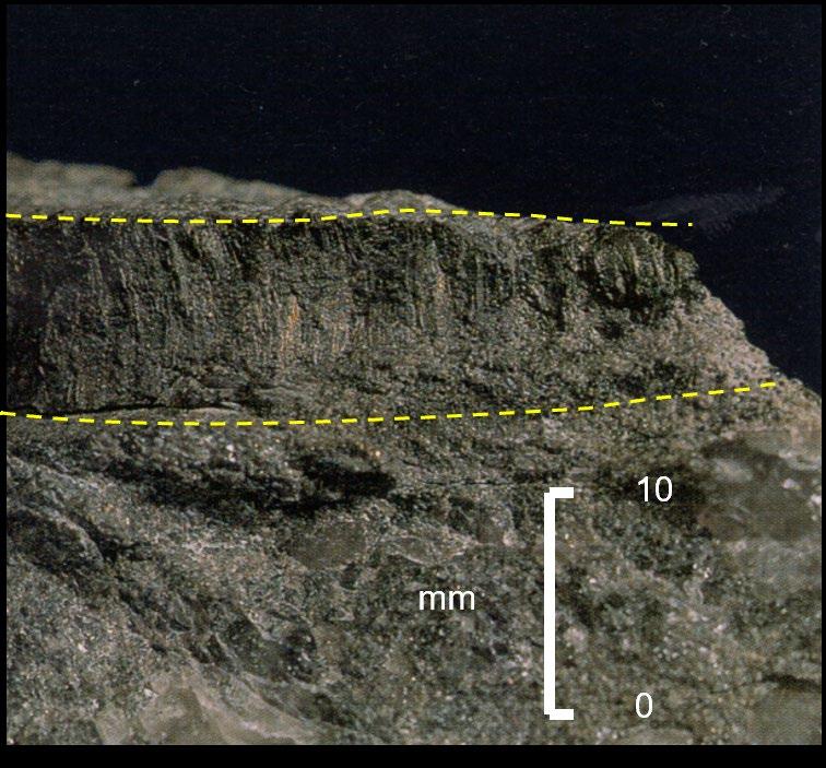
In this study, the gold was mined from the Leader Reef Zone (LRZ), which forms part of the Johannesburg Subgroup of the Central Rand Group of the Witwatersrand Supergroup, at around 900 m depth below surface. The LRZ can be subdivided (Figure 4) into a lower channelised unit (Alma Member, Lower Unit, or LU), a middle sheet-like unit (Bedelia Member, Middle Unit, or MU) and an upper, disseminated gravel interval (Leader Quartzite or Upper Unit). The LU has a highly erosive base while the MU is sheet-like (Figures 5 and 6). Both Units average around 90 cm in thickness, and are usually conglomeratic, made up of very well rounded, medium to large quartz pebbles, with a quartzite matrix. The matrix contains buckshot pyrite (Figure 7), uraninite, flyspeck carbon and carbon seams (particularly near the basal contact) and disseminated gold (Figure 8). Trough cross-bedding may be picked out by pyrite grains and other dark heavy minerals (Figure 9).
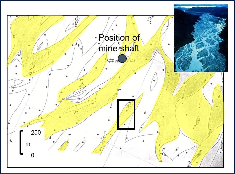
The interpreted environment of deposition of the LU and MU is a braided river deposit (Figure 10) overlain by a thin, possibly reworked, amalgamated channel belt or shallow marine, upper shoreface deposit (Els and Mayer 1998). Gold pay trend maps (Figure 11) can be used to map out the braid bars of the LU, which is interpreted as having been deposited in a series of channels (depositing fining-upward cycles), around 100 to 200 m in width, and with a relief of at least two metres. The scour surfaces present in these channels indicate that they were filled during successive phases of gravel and sand deposition by large flood events. The braided river deposits are bounded by areas of Waste on Contact, upland areas where no fluvial deposition occurred. Overlying the LU is the sheet-like MU. A possible depositional model relates to a relative rise in sea level (Figure 12), with reworking of the underlying fluvial deposits and deposition of gravelly shoreface deposits with a winnowed base. Sedimentological evidence can also be explained by a thin, amalgamated, fluvial channel belt, which could relate to a stillstand in relative sea level.
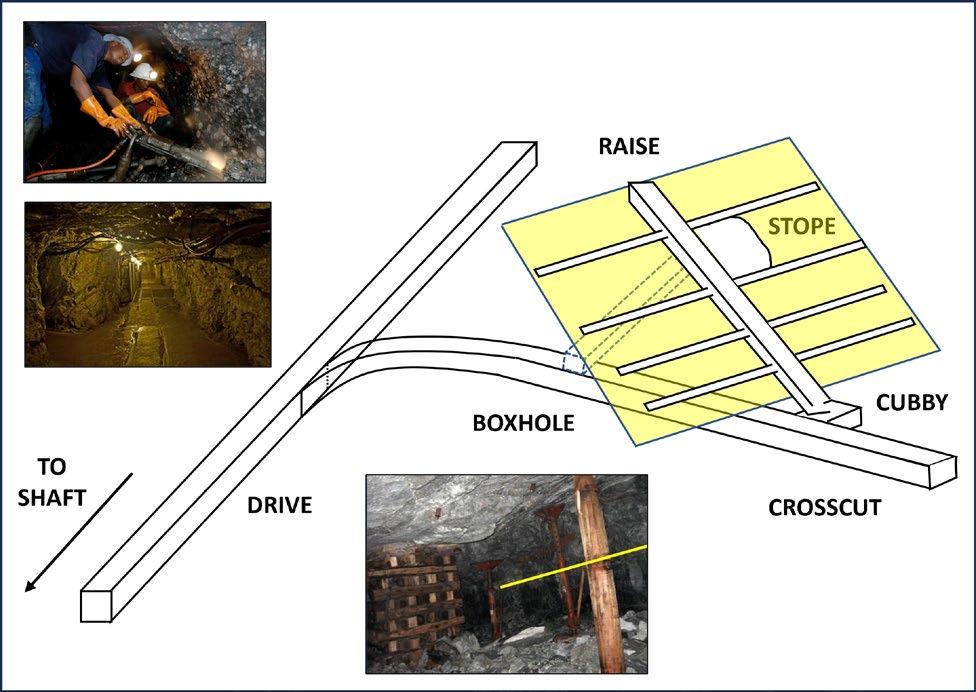
MINING METHODOLOGY
Mining in the Witwatersrand gold mines is typically undertaken using a stoping technique (Figure 13). Initially, horizontal drives are excavated along strike some forty metres below the ore body. There are two main ore bodies in the St. Helena Gold Mine: the Basal Reef and Leader Reef. Each is a sheet-like conglomerate with varying proportions of quartzite matrix, around 30 cm to 600 cm in thickness and dipping at around 20 degrees. The conglomerates are cut by faults, some of which have been later intruded by dykes.
RESERVOIR ISSUE 2 • MAR/APR 2024 25
FIGURE 1
FIGURE 2
Map of the Witwatersrand Basin
Principal reefs in the Free State Goldfield
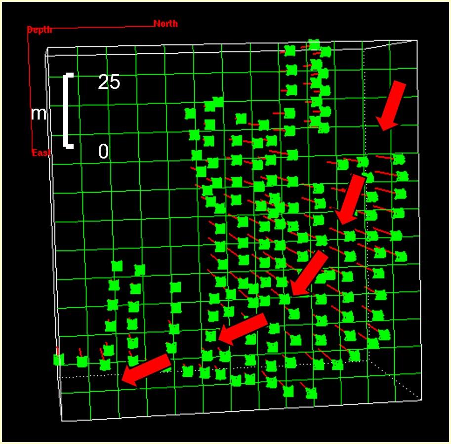
Crosscuts are excavated, branching off the drives and extending perpendicular to them until they intersect the ore body. Then a raise will be mined on dip, following the ore body until it reaches the next crosscut level, usually 40 metres vertically above the initial crosscut. Once the raise has been completed box holes are developed from the crosscut at around 80 degrees to intersect the raise along its length. Then stoping begins, moving laterally (along strike) from the raise. The resulting ore is “swept” by a series of scrapers into the raise, and then down to the nearest box hole. Locomotives stop beneath the box hole and the ore is released from the box hole and fills the rolling stock. Depending on the number of blasts (usually one per day), stoping proceeds at about 1 metre per day. This allowed an excellent opportunity to collect sedimentological data and samples for assay, as mining continued. Vertical sections were measured after every few blasts (with a horizontal spacing of around 5 metres), to ensure that full coverage of the mined pay interval was being maintained. A total of 156 sections ranging from 1 to 4 metres in thickness were logged in an area of around 150 x 150 metres (Figure 14), covering a bend in an individual channel. The channel is estimated to have a width of around 200 metres. Samples were taken for gold assay at around 7-10 cm intervals vertically through each of the measured sections.
26 RESERVOIR ISSUE 2 • MAR/APR 2024
FIGURE 3
FIGURE 4
Map of mined sections in St. Helena Gold Field (grey areas, left hand polygon)
Detailed stratigraphy of the two reefs at St. Helena Gold Mine
RESERVOIR ISSUE 2 • MAR/APR 2024 27
FIGURE 5
FIGURE 8
FIGURE 9
FIGURE 10
FIGURE 6
FIGURE 7
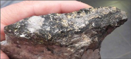
Underground outcrop of the Leader Reef (metre rule spans Lower and Middle Units)
Hand specimen from St. Helena Gold Mine with visible gold in a carbon seam
Cross-beds in quartzite in Lower Unit, Leader Reef
Depositional model for Basal Reef - also applies to Lower Unit (Goldfields)
Annotated sketch of underground outcrop of the Leader Reef
Reef with quartzite pebbles and buckshot pyrite
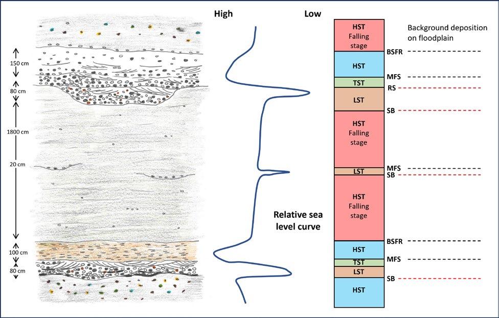
Possible sequence stratigraphic interpretation of the succession seen underground
28 RESERVOIR ISSUE 2 • MAR/APR 2024
FIGURE 14
FIGURE 11
FIGURE 12
FIGURE 15
FIGURE 13
Pay trends showing braid bars (study area in black rectangle)
Map of stope with measured points
Gold values as proxy for porosity model
Underground mining methodology
MODELLING POROSITY DISTRIBUTION
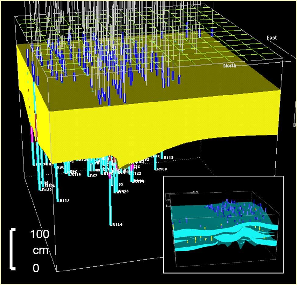
Gold values ranging from 0 to 125 grams/tonne were recorded from these rocks. As described in the Introduction, the working model (Figure 15) is that the fluvial deposits originally hosted hydrocarbon deposits, which were later metamorphosed to pure carbon (Gray et al 1998; England et al 2002). Remobilized gold carried by hydrothermal fluids was then introduced into the pores, forming an amalgam with the carbon (Figure 16). Gold values should increase with increasing carbon concentrations, which in turn will indicate original oil saturation, so the gold values can be used as a proxy for primary porosity. Kriging of the gold values in a 3-D modelling program (Figure 17) allowed the interpolation of a 3-dimensional “pseudo” porosity cube through the channel and overlying sheet sand (Figures 18, 19 and 20).
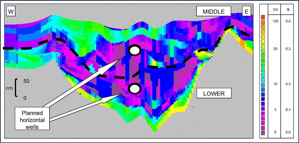
The results demonstrated that the gold values were concentrated along the basal channel contact, and at the base and top of the sheet-like interval. The values were lowest in the upper part of the channelised succession. These gold concentrations either represent the highest energy horizons, where the coarsest material, with the highest porosity, would be transported and deposited, or suggest that at least part of the gold is in fact detrital, and has been concentrated in stratigraphic intervals where winnowing has occurred. In either case, this would suggest that, to maximise sweep by targeting low porosity intervals, horizontal wells should be drilled through the upper portions of channelized deposits and through the middle sections of thin shoreface or amalgamated channel sandstone beds. Drilling into the winnowed intervals would be likely to intersect high perm streaks and lead to early water breakthrough.
RESERVOIR ISSUE 2 • MAR/APR 2024 29
FIGURE 16
FIGURE 17
FIGURE 18
FIGURE 19
Carbon seam with gold stringers
3-D model of the stope with 156 data points
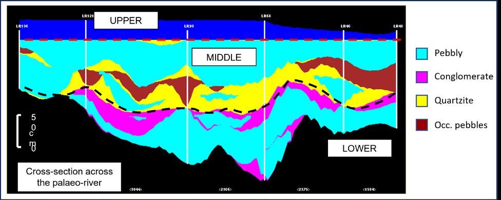
Cross-section through 3-D facies model
Cross-section through 3-D porosity model
CONCLUSIONS
This study provides an object lesson in the use of 3-D mining data to create highly detailed models which can then be used as analogues for subsurface oil and gas reservoirs, or for carbon sequestration. The behaviour of these reservoirs can be better predicted as a result.
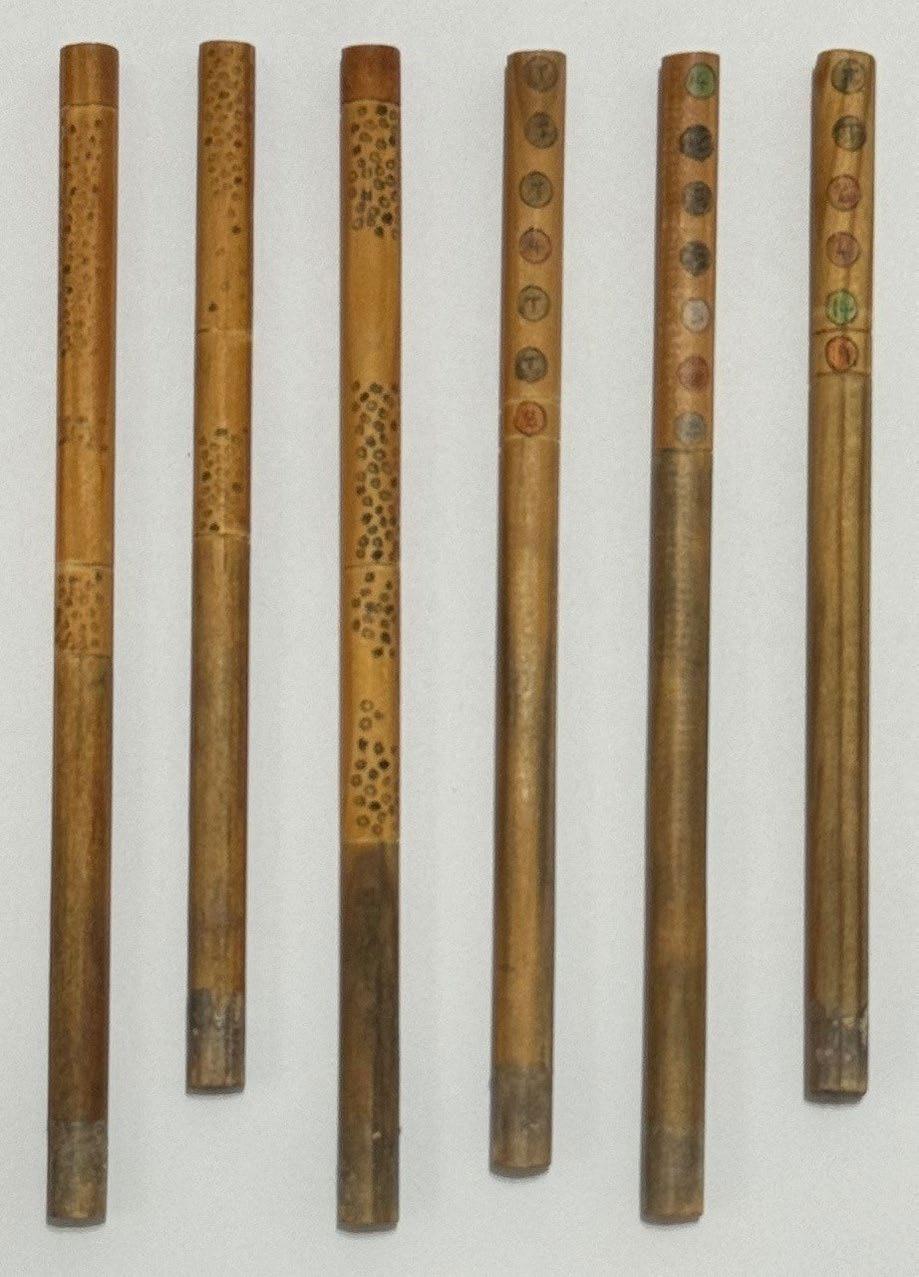
Fun note: I worked on the St. Helena Gold Mine for 3 years in the late 80s (Figure 21). After collecting the underground data, I created a 3-D model using a 1 m x 1m wooden base; 156 dowelling rods
(Figure 22); and
to
to create 3-D stratigraphic surfaces at the contacts. We have come a long way since then!
30 RESERVOIR ISSUE 2 • MAR/APR 2024
Series of cross-sections through 3-D porosity model
FIGURE 20
embedded into the baseboard, each wooden rod annotated (using a Rotring pen) with facies and gold values
coloured string, running from dowel
dowel,
(facies and gold values in grams per tonne)
SELECTED REFERENCES
Els, B.G. and Mayer, J.J. (1998). Coarse clastic tidal and fluvial sedimentation during a large late Archaen sea-level rise: the Turffontein Subgroup in the Vredefort structure, South Africa. In: Tidalites: Processes and Products, SEPM Spec. Pub. 61, 155-165.
England, G.L., Rasmussen, B., Krapez, B. and Groves, D.I. (2002). Archaean oil migration in the Witwatersrand Basin of South Africa. Journal of the Geological Society, London, 159 , 189-201.
Gray, G.J., Lawrence, S.R., Kenyon, K. and Cornford, C. (1998). Nature and origin of ‘carbon’ in the Archaean Witwatersrand Basin, South Africa. Journal of the Geological Society, London, vol. 155, pt. 1, 39-60.
Hallbaeur, D.K. (1975). The plant origin of Witwatersrand carbon. Mineral Science Engineering no. 7, 111-131.
Karpeta, W.P. (1991). Hydrocarbon occurrence in the Vaal Reef and A-Reef placers: sedimentological controls and economic significance. In: Carbon in Witwatersrand Reefs Symposium; Geological Society of South Africa, June 1991, 57-59.
Kirk, J., Ruiz, J., Chesley, J., Titley, S. and Walshe, J. (2001). A detrital model for the origin of gold and sulphides in the Witwatersrand Basin based on Re-Os isotopes: Geochimica et Cosmochimica Acta, v. 65, pp. 2149-2159.
Kirk, J., Ruiz, J., Chesley, J. and England, G. (2002). A major Archaen gold and crust-forming event in the Kaapvaal Craton, South Africa: Science, v. 297, pp. 1856-1858.
Minter, W.E.L. (1976). Detrital gold, uranium and pyrite concentrations related to sedimentology in the Precambrian Vaal Reef placer, Witwatersrand, South Africa. Economic Geology no. 71, 157-176.
Noad, J.J. (2002). Black gold – co-mingling mining data and oil modelling methology. Poster abstract. IAS 16th International Sedimentological Congress, 2002, Johannesburg, South Africa.
Noad, J. 2004. Static Reservoir Modelling of Ancient Fluvial Metasediment Deposits: Implications for Modelling Sequences where Fractures are a Significant Production Mechanism. Proceedings of the Libya Petroleum Conference, Beirut, Libya.
Parnell, J., Watt, G.R., Middleton, D., Kelly, J. and Baron, M. (2004). Deformation band control on hydrocarbon migration. Journal of Sedimentary Research, vol. 74, 552-560.
Pryor, W.A. (1973). Permeability-porosity patterns and variations in some Holocene sand bodies, AAPG Bulletin, vol. 57, p. 162-189
Ruiz, J., Valencia, V.A., Chelsey, J.T., Kirk, J.,Gehrels, G., and Frimmel, H. (2006). The source of gold for the Witwatersrand from Re-Os and U-Pb detrital zircon geochronology: Geochimica et Cosmochimica Acta, v. 70, p. A543.
Watanabe, Y., Martini, J.E.J. and Ohmoto, H. (2000). Geochemical evidence for terrestrial ecosystems 2.6 billion years ago. Nature, vol. 408, 574-578.
https://www.goldfields.com/reports/goldfields_ rr_dec2010/m_sa_beatrix_setting.php
RESERVOIR ISSUE 2 • MAR/APR 2024 31
FIGURE 21
FIGURE 22
Your author with St. Helena #2 Shaft in the background circa 1988
Dowelling sticks with annotations
2023 STANLEY SLIPPER AWARD
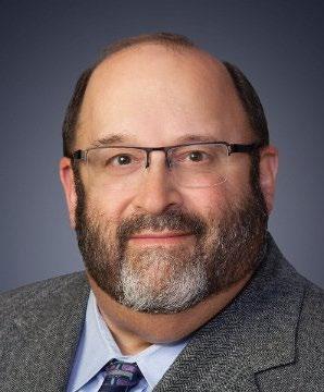
The Stanley Slipper Gold Medal for 2023 is awarded to Dr. Brian Zaitlin, in recognition of his outstanding career as a leader in the Canadian oil and gas industry, as well as his role as a mentor and teacher.
DR. BRIAN ZAITLIN
Dr. Zaitlin has worked for over 45 years as an innovative researcher, stratigrapher, sedimentologist, and exploration and development geologist in the industry. His career has covered a diverse spectrum of projects involving clastic and carbonate reservoirs and complex stratigraphy and structural plays, particularly in the Western Canadian Sedimentary Basin (WCSB) and Northern USA. He is well known throughout the global geology community for his pioneering ideas on incised-valley fills (IVF) and estuarine facies models.
Brian graduated with a B.Sc. in Geology in 1979 from Loyola College/ Concordia University and an M.Sc. in Geology from the University of Ottawa in 1981. He then began his industry career with Gulf Corporation in Calgary. In 1982, Gulf Corporation sent Brian on a field trip in the Bay of Fundy led by Dr. Bob Dalrymple. Brian realized he was seeing similiar estuarine and IVF processes that he had identified with Bruce Shultz in the Lower Cretaceous Senlac Lloydminster oil pool in Saskatchewan.
As Brian had always planned to obtain his doctorate, he applied and was accepted for graduate studies with Dr. Dalrymple at Queen’s University (1983-1987). Along with Dr. Ron Boyd (Dalhousie University), Dr. Dalrymple and Brian brought their respective unique experiences together, which led to a seminal paper on estuarine facies: Dalrymple R.W., B.A. Zaitlin, and R. Boyd, 1992, Estuarine facies models: conceptual basis and stratigraphic implications: Journal of Sedimentary Petrology, v.62, p. 1130-1146. This paper was selected
in 2017 by the American Association of Petroleum Geology (AAPG) as one of the “Top 10 Landmark Papers in Siliciclastic Sedimentology” in petroleum geoscience over the last 100 years. Dr. Dalrymple writes that the paper “is based entirely on a set of fundamental concepts that Brian originated.”
Dr. Zaitlin received the outstanding Ph.D. Thesis Award from the Canadian Society of Petroleum Geology (CSPG) in 1987 for his doctorate work on the Cobequid Bay — Salmon River Estuary in the Bay of Fundy. His subsequent publication on incised valley systems in 1994 co-authored with Dalrymple and Boyd is considered a standard reference for the architecture of incised valleys and estuarine systems.
Following a year of post-doctorate work at the University of Sydney in Australia, Dr. Zaitlin joined Esso Canada Resources in 1987 and worked in exploration geology for six years, mapping prospects in Northern Alberta/Northeastern British Columbia (NEBC). Dr. Tom Moslow writes that “Brian led the sedimentologic and stratigraphic efforts of a team of geoscientists at ESSO (Imperial) Research (with David James, Henry Posamentier and others) that conducted a regional evaluation of the Montney Formation which led to one of the first discoveries of the Montney turbidite play in west-central Alberta … at Manir.”
In 1993, Brian left Esso and began working at PanCanadian Energy (later known as Encana Corporation) in various roles including technical specialist, team lead, and Exploration Advisor. Brian became the team lead for various task forces pursuing Cretaceous-age prospects.
32 RESERVOIR ISSUE 2 • MAR/APR 2024
Dr. Tom Moslow writes that “Brian led a successful and economic drilling program pursuing the IVF reservoir model within more poorly understood Mannville reservoirs in Southern Alberta.” Later, Brian was the geological lead on an integrated team that quantified the reserves component of the successful $702MM Canadian/USA Montana Power acquisition for which he was subsequently awarded the PanCanadian Presidents Award. In 2001 Brian became Exploration Advisor in PanCanadian Energy’s Great Plains Business unit and co-directed the exploration/development team in evaluating opportunities in southern Alberta, northern Montana, and various US Rocky Mountain Basins. He later became the team lead for the New Plays group. These programs resulted in several successful exploration and acquisition opportunities that were followed by extensive drilling programs, including identifying a new multi-BCF Mississippian Basin Centered Gas play in the Liard Basin.
In 2004 Dr. Zaitlin joined Suncor Energy Inc. as a Senior Exploration geologist in the Prospect Generation Services team (PGS). Brian was given latitude to pursue creative exploration ideas and prospects during this time and developed many drill-ready opportunities in Saskatchewan (Lower Mannville), NEBC (stacked Cretaceous to Triassic), Southern Alberta, and NW Alberta (Triassic).
Dr. Zaitlin subsequently moved to Enerplus (Enermark) Resources Fund in 2008 as Chief Geologist and was responsible for helping develop the exploration portfolio (Canadian/USA). He was also responsible for training and mentoring of geological staff. Shelley Leggett was also working at Enerplus Resources Fund at the time and writes that “Brian had a tremendous impact on new ideas and concepts adopted into various business units extending from the NEBC regions in the Charlie Lake and Halfway units south and eastwards into the Mississippian units of SE Saskatchewan.”
In 2010, Dr. Zaitlin made a radical career move and accepted the Chief Geologist position with the Bank of Montreal (BMO) Capital Markets A&D Advisory Group. His role was to provide technical evaluations for acquisitions, dispositions, and mergers in the energy sector.
During this time, Brian had a rewarding experience working with Indigenous groups. In 2011 Brian became Chief Geologist with Native American Resource Partners (NARP) and director with Kainai Energy following up on the Wabumun—Exshaw—Banff (WEB) play. He describes his role as “providing technical, operational and strategic analysis for their portfolio and new investments.”
In late 2013, Dr. Zaitlin joined EOG Resources Canada as an Exploration Advisor with a mandate to identify new play opportunities for the company and mentor junior staff. Shelley Leggett writes that Brian’s skills helped EOG “develop some predictive models to help EOG pursue leading edge ideas that moved our efforts forward in identifying unconventional targets.”
Dr. Zaitlin started up his own consulting business, Zaitlin Geoconsulting Ltd., in 2015 to provide new venture and prospect evaluation to interested energy clients. He worked on many projects for large and small clients, for projects ranging from Devonian/Mississippian-age unconventional opportunities to Triassic and Cretaceous-age clastic systems in Canada. Brian also completed reports on the Northwest
Australian Shelf, the North Sea, Columbia, and New Zealand in conjunction with Dr. Brad Hayes at Petrel Robertson Ltd (PRCL).
From 2016 to present day, Brian has also taken on a very different role as one of the Hearing Commissioners with the Alberta Energy Regulator (AER). Their responsibilities include conducting hearings for energy applications and regulatory appeals and helping to develop the AER’s hearing procedures, rules, and processes for alternative dispute resolution. This work gives Brian a strong sense of accomplishment as Hearing Commissioners are independent adjudicators, appointed by the Government of Alberta’s Orders in Council.
In addition to his industry work, Dr. Zaitlin has been a prolific contributor to published journals and has presented and co-authored over 120 different talks at petroleum geology conventions and core conferences across Canada and internationally. His work has been published in journals including the CSPG Bulletin, Journal of Sedimentary Research, Sedimentology, SEPM Special Publications, AAPG Bulletin and the Canadian Journal of Earth Sciences. He has been a co-editor for three sedimentary geology books.
Dr. Zaitlin also regularly taught courses during his career and has been an instructor or co-instructor for over 60 courses, field guides, workshops and core conferences presented to companies, universities, geological societies, and government bodies. He volunteered his time with many technical committees and as an editor with CSPG and SEPM publications. Since 1983, Brian has been co-convenor or committee member for 19 geological conferences held in Calgary.
Brian has received many industry awards and honours. He has been recognized by the CSPG several times (Ph.D. Thesis Award 1987, Service Awards 1991, 1992; Co-Author Best Oral Paper 1995; Tracks Award 1999; Lead Author Medal of Merit 2002; Honorable Mention Best Oral Paper 2003; Volunteer Award 2008; CSPG Ambassador Program 2019). Brian has also won awards from international geological societies including SEPM for oral presentations (Co-author, Excellence of Oral Presentations 1997, 1999) and AAPG (Distinguished Lecturer 1996/1997). He also received Enerplus Resource Fund’s President Award in 2009, as well as the Canadian Society of Unconventional Resources (CSUR) Sproule Achievement Award in 2011. Dr. Tom Moslow adds that Brian’s “insight into subsurface sedimentologic and stratigraphic reconstructions is legendary ... his creativity in solving complex geological problems is remarkable.”
Looking over his career, Dr. Zaitlin feels that his success is due to “always being a learner, working in teams … seeing a lot of geology, and networking.” He believes in following Dr. Guy Plint’s advice: “Take every opportunity to get into the field.” Brian also wishes to acknowledge his career was not possible without the overwhelming support of his wife Beryl, and their three daughters.
Dr. Brian Zaitlin’s outstanding advancement of major hydrocarbon plays in the Western Canadian Sedimentary Basin through pioneering and publishing of geological concepts, his passion and extensive technical leadership for detailed petroleum geology exploration and development, as well as his ongoing mentorship to the geological community, make him the deserving recipient of the CEGA Stanley Slipper Gold Medal for 2023.
RESERVOIR ISSUE 2 • MAR/APR 2024 33
HONORARY MEMBERSHIP AWARD
DR. FRANKLIN A. STOAKES
Frank has had a lifelong passion for geology, particularly the study of Devonian carbonates, which started in grammar school in England where in 1967 he took ‘A’-level geology under the tutelage of his teacher Coral Jones! He received his B.Sc. (Hons) in geology in 1973 from Kingston Polytechnic, now Kingston University, in London, and after a short stint as a mudlogger on the UK North Sea, headed to Canada, where in 1975 he received his M.Sc. from the University of Windsor, for work on Devonian carbonates of the James Bay Lowlands. Encouraged by his advisor, the late Bob Jull, he continued his studies at the University of Calgary on an Isaak Walton Killam Memorial scholarship, where in 1979 he received his Ph.D. for work on Devonian reef growth and basin fill, under the supervision of the late Alan Oldershaw and Ed Klovan.
From there he joined the oil industry in Calgary, working for Esso Resources Canada Limited with assignments in both exploration and research. At Esso he worked under the late Perry Glaister and also found a carbonate mentor in Jack Wendte, with whom he could share ideas. Together they taught in-house Ancient Carbonate courses as well as set up Modern Carbonate courses for staff in Florida and the Bahamas. It was at Esso that Frank became a true ‘Friend of the Devonian’, working on many reservoir and exploration projects with his colleagues. One reservoir study on the Nisku section of the Obed area led directly to the drilling and discovery of the 300 Bcf Obed field in the deeper updip Leduc section. It was at Esso that Frank also met Steve Creaney, an organic geochemist, and together they started work that defined the fundamental petroleum geochemistry (accumulation, maturation and migration) of the Duvernay Formation in Central Alberta.
In 1985 Frank left Esso to pursue his desire to consult for industry, initially joining RPI Canada Limited, where he met Clarence Campbell. With the untimely demise of the RPI group of companies the following year (not their fault!) Frank and Clarence embarked on a new adventure, Stoakes Campbell Geoconsulting Limited (SCG), later to become Stoakes Consulting Group Limited (SCG) when Clarence returned to his native Nova Scotia. Geographic separation didn’t stop them from working on joint projects and more so after Clarence returned to Calgary
and rejoined the company. The team of geologists at SCG described over 11,000 cored wells, totalling over 200 kilometres of core, which were digitized and put into an interactive database (StoneCode Geoware). Since 1986 SCG has undertaken 60 major regional geologic studies, numerous smaller studies and 20 international projects. SCG also taught over 50 Ancient Carbonate courses primarily in Western Canada but also in places as diverse as Turkey, China and Pakistan. Modern Carbonate field courses were held in Florida and the Bahamas (18 times) and Belize, Central America (23 times). The content and concepts conveyed in these courses have influenced a generation of geoscientists. With increasing maturity of the basin, the project focus at SCG changed, starting with acid gas disposal projects jointly assisted by Harvey Heinrichs. SCG was also lead geologist with a group put together by Shell Canada in 2006 that identified and focused on the Basal Cambrian Sandstone as a sequestration target for what later became the Shell Quest Project. One area that Frank thought he would probably never work in was the Athabasca Oil Sands. That all changed in 2008 with the threat of water influx from the underlying Devonian aquifer in some areas and the search for water disposal in others.
Frank is a recognized authority on the Devonian of the Western Canada Sedimentary Basin (WCSB). Throughout his long career he has authored and coauthored numerous abstracts, talks, short courses and papers primarily on the Devonian of the WCSB. He has won numerous awards, including: two CSPG Medals of Merit (1980 and 2018), a CSPG Link Award (1986), and he was CSPG Distinguished Lecturer (1987). He has long sought to teach, mentor and educate, but most importantly to understand and unravel the depositional and diagenetic history of the Devonian succession of the WCSB.
Frank presently divides his time between Canada and Belize, where he can ponder depositional processes using a mask, snorkel and dive tank. As a ‘Friend of the Devonian’ Dr. Frank Stoakes is a worthy recipient of honorary membership in CEGA and he wishes to thank all of his family, friends, employees (especially Drue Robinson), clients and compatriots for supporting him over the years and CEGA for bestowing on him this honour.
34 RESERVOIR ISSUE 2 • MAR/APR 2024
HONORARY MEMBERSHIP AWARD
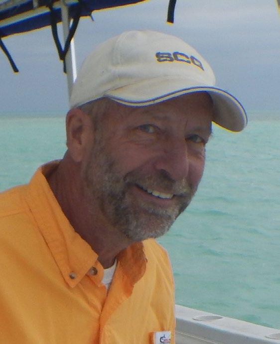
TAKO KONING
Tako Koning is Holland-born and Canada-raised, with a B.Sc. in Geology (1971) from the University of Alberta and a B.A. in Economics (1981) from the University of Calgary. He has been a CEGA member for 48 years, since joining in 1975. He began his working life as a mud-logger for two years offshore Newfoundland before continuing with oil and gas exploration and development for Texaco in Western Canada.
Most of his 45 working years were spent overseas in Indonesia, Nigeria, and Angola. During his time working in West Africa, Tako collected geology textbooks and other educational publications while visiting Canada. He would then transport and donate these items to universities in Nigeria and Angola. This was part of his major “Books for West Africa” project.
Tako became extremely interested in basement reservoirs after working on an oil pool in fractured and weathered basement in Sumatra, Indonesia. He has published extensively on basement reservoirs, and presented at conventions, conferences and symposiums worldwide. In addition, he is the author or co-author of over 200 technical papers, abstracts or articles focused on geology, oil and gas subjects, and more recently, on paleontology and the global energy transition. He has given presentations at over 20 locations in North and South America, Asia, Africa, the Middle East, and Europe.
Now partially retired and back in Canada, Tako has continued his professional life with membership in many technical societies: APEGA, CEGA, CSEG, APS, AAPG, SPE and AWA. He still attends and presents papers at many conventions, most recently three papers at GeoConvention 2023 and URTeC 2023 in Argentina. He
continues to lead his annual “Tyndall Stone tour” for the CEGA and his annual field trip to the K/Pg mass extinction boundary near Huxley, Alberta. Another annual field trip he runs is for the Alberta Wilderness Association and is focused on orphan oil and gas wells, environmental geology, and glacial geomorphology. Extra-curricular activities as a volunteer include contributions to the Rosedale Community Association and serving as a board member for the Calgary Justice Film Festival. Since 2001 he has been a member on the International Advisory Board, Africa Oil + Gas Report, Lagos, Nigeria.
Tako volunteered with the CSPG International Division from 1988 – 1992 and the CSPG’s Visiting Petroleum Geologist program from 1989 - 1992.
For his volunteering and community involvement Tako was awarded the 1991 CSPG Tracks Award; 1994 Honorary Life Membership in the Nigerian Association of Petroleum Explorationists; 1999 Nigerian-Canadian Associations’ Humanitarian Award, 2007 Regional Service Award for Africa from the Society of Petroleum Engineers; 2008 Alumni Honor Award from the University of Alberta; 2010 Public Service Award from the American Association of Petroleum Geologists; and in 2022 the Great Gray Owl Award from the Alberta Wilderness Association.
Tako continues to demonstrate his life-long dedication to CEGA and the national and international geoscience community. He has represented his country and the geoscience profession both at home and around the world, making significant technical and humanitarian contributions.
RESERVOIR ISSUE 2 • MAR/APR 2024 35
2023 PATRICIA J. LEE TRAILBLAZER AWARD
MATT YOUNG
CEGA is delighted to award the 2023 Patricia J. Lee Trailblazer Award to Matt Young, VP Exploration at Spur Petroleum, for the extraordinary work that he and his team conducted to explore and produce the Clearwater oil fairway using cold flow multilateral drill technology. This drilling technique had been written off by several operators in the WCSB for this reservoir/hydrocarbon type, but Spur’s success brought life to a play that had been bypassed for decades. Matt’s understanding of its development potential was far ahead of industry peers and his advocacy and collaboration skills directly led to the discovery of several massive oil pools in the Clearwater fairway, starting at Marten Hills in 2015.
Years before the Marten Hills discovery, the idea for multilateral drilling in the Clearwater fairway was being tested by Spur in the Central Alberta Whitford region 100 kilometers to the south. The Whitford pool proved to be the testing grounds for future Clearwater drilling as Spur refined various well designs and the crucially important drilling fluid design. Along with the lessons learned in Whitford, Matt and his team applied key foundational geologic principles, such as detailed stratigraphic architecture, sedimentological analysis and reservoir characterization to challenge industry cutoff norms to identify new prospects within this prolific fairway.
In December 2015 Spur drilled the first two multi-lateral horizontal wells at Marten Hills, resulting in a significant discovery. The multilaterals were challenging to drill and cross disciplinary management was required for ideal lateral placement to optimize well performance. Matt collaborated with engineering and drilling staff to unlock and solve various challenges to ensure success.
The Clearwater Formation has grown rapidly since its discovery and is one of the most sought-after formations in Canada due to its industry-leading economics. Today, Spur Petroleum is recognized as the pioneer in this play (Daily Oil Bulletin, 2022). Remarkably, despite a rapid influx of competitors, Spur remains the dominant producer and landowner nine years later. Matt and his team’s discovery and development success have had a direct impact on the development of regional infrastructure and revenue generation for the province of Alberta.
Matt Young and his team at Spur Petroleum exemplify the characteristics of Trailblazer winners. Their ability to generate a unique idea (cold flow multilateral drilling in semi-conventional Clearwater reservoirs), develop a strategy around how to best implement that idea (through extensive land capture strategies) and improve (through close collaboration across disciplines) is an exemplary model for our industry.
36 RESERVOIR ISSUE 2 • MAR/APR 2024
RESERVOIR ISSUE 2 • MAR/APR 2024 37
The Blue View: Industry Trends Through Woodmac’s Lens
NORTH AMERICA IN CONTEXT: OVERARCHING THEMES ACROSS THE INDUSTRY
Canada upstream: Key trends and developments
CANADA
Emissions reduction top of mind for Canadian producers
n Canada upstream: Key trends and developments
Increased Production: Canada’s upstream energy sector is poised for growth, with annual production expected to surpass nine million barrels of oil equivalent per day for the first time this year. This milestone is largely driven by the Trans Mountain Expansion (TMX) pipeline, which will increase Western Canada’s oil export capacity by 16% upon its completion in the second quarter of 2024. Despite its cost ballooning to 5.7 times the initial estimate, TMX is crucial for facilitating additional oil flows of 590,000 barrels per day.
New egress coupled with strong oil prices will encourage a mini-boom in debottlenecking and low-cost expansion oil sands projects. Capital discipline remains and shareholder returns are key, but oil prices remaining over $70/bbl supports a return to spending capital on growth.
Canadian M&A spend exceeded US$10 billion dollars in each of the last four years. We expect deal activity to stall among the larger Canadian operators Crescent Point, Baytex, Whitecap, and Strathcona as they ingest sizeable 2023 acquisitions. The oil sands are now consolidated under committed operators following the sale of TotalEnergies oil sands assets. We anticipate the focus of M&A activity to shift towards the Montney and Duvernay.
As the 2025 startup of LNG Canada approaches, deal-making could increase in the Montney, which is set to see significant capital investment and production growth. Companies with strong balance sheets, such as Tourmaline and ARC Resources, are in a good position to lead this activity. Annual Montney capital spend will be the third highest nominal amount ever (US$6.8 billion, behind only 2013 and 2014) and output will zoom past the two million boe/d mark (10 bcfd gas). Small-cap players do not have the capacity for large deals, but they will also be active. Serial dealmaker, CNRL, holds an equity premium and fortress balance sheet strength that could be deployed. But historically the company has been counter cyclical in its acquisition strategy and commodity prices are not conducive to low price-point deals.
n Emissions reduction top of mind for Canadian producers
Canada is under pressure to accelerate the energy transition. The country aims for a 40–45% reduction in greenhouse gas (GHG) emissions by 2030 from 2005 levels. However, significant reductions are yet to be achieved, especially with only eight years left to meet this target.
OFS operators predict 2024 activity levels
1. 2. 3. 4.
US Independents: 2023 preview and 2024 outlook
Canada’s GHG emissions have remained stubbornly stable, ranging between 670 Mt and 750 Mt over the past 15 years as population and upstream contributions increased.
Alberta’s methane reduction target (a 45% drop from 2014 levels) was achieved three years ahead of the 2025 goal. But the focus on Canada’s environmental performance will only increase. Particularly pressing is the acceleration of emissions reductions in the oil sands sector, a critical step on the path to achieving net-zero emissions by 2050.
2024 should mark the year when the oil sands Pathways Alliance moves from engineering studies to large-scale project spending. Progressing the project is vital to the industry’s future and meeting both corporate and country-level emissions goals. With anticipated co-investment support from the federal and Alberta governments, Pathways Alliance has proposed to invest Cdn$24.1 billion before 2030 in the first phase of its 22 Mt CO2/year reduction plan. Large ticket capital spend will begin on Phase 1 of Pathways, despite regulatory approval and formal FID not being expected until mid-2025.
The introduction of commercial solvent technology reflects a multi decade progression of countless pilots by most operators within the oil sands to develop cost effective and environmentally sustainable emissions reducing extraction technologies. As the grandfather of in situ commercial recovery with a production history of almost 50 years, Cold Lake will be one of the locations were commercialization of solvents will be progressed, as Imperial will bring on 15,000 barrels per day from the Grand Rapids Formation. Next door, CNRL at Primrose has also been piloting solvent technologies, and will start-up pads in Kirby. Most
WOOD MACKENZIE OIL SANDS EMISSIONS OUTLOOK
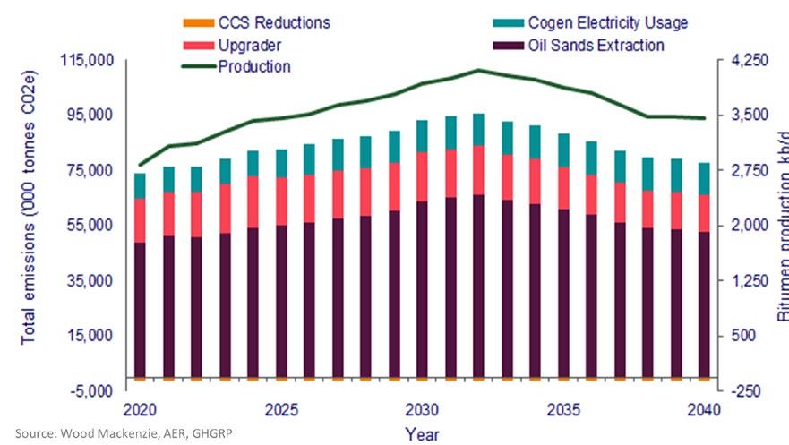
38 RESERVOIR ISSUE 2 • MAR/APR 2024
solvent results have been confidential, with companies guarding results. As results become public, it will be of significant interest whether solvents will become part of the arsenal oil sands operators will use to reduce the overall high emissions intensity of in situ oil sands extraction and whether their economic benefit justifies the relatively high cost.
LOWER 48
n OFS operators provide insight into North American activity
As earnings season kicks into gear, the big three oilfield service (OFS) operators give us a glimpse into Lower 48 activity and stakeholder sentiment for 2024. Despite the drop in rig counts, FY2023 North America revenue growth was strong for all three. Halliburton and Baker Hughes realized a 9% increase in North American revenues over 2022 while Schlumberger reported an impressive 12% increase.
• Halliburton expects North American activity and margins to remain flat in 2024 as operators shift focus from D&C savings to improved recovery and productivity. HAL has seen strong demand for its e-fleets, which represent 40% of its contracted frac fleet for 2024 and expects this figure to grow to 50% by 2025. Given that these fleets will be on multi-year contracts, HAL should be able to maintain margins. The company is taking a demand-pull approach to build-out its Zeus e-fleet as it maintains capital discipline and retires lower-tier diesel fleets for e-fleets, thereby maintaining fleet count.
• Schlumberger has a smaller footprint in the Lower 48 but expects its fit-for-basin strategy and technology offerings in the region to drive value. Notably it sees US operators focusing more on efficiency and recovery; as a result there is little indication of pressure to lower prices in response to the decline in oil and gas prices in recent months.
• Baker Hughes expects US onshore spending will decline in the low to mid-single digits in 2024. That view reflects the exposure BKR carries with services in L48 tied heavily to the US rig count. The call touched on the company’s outlook for upstream capex through the end of the decade. BKR expects North American capex to remain flat into 2030. A consistent throughline among these calls was the expectation that onshore US activity will remain muted in 2024. That tracks with our latest short-term outlook, which assumes the 2024 rig count averages 5% lower than 2023. However, all three OFS companies are forecasting strong margins in the space. This indicates stickiness in service cost inflation. Among these companies, there is a focus on growing the digital services that provide enhanced recovery and productivity improvements to operators. If these services do not deliver results – or if they work too well and reduce the demand for equipment - it could undermine the price floor OFS operators seem to currently enjoy. Patterson-UTI, Nabors, ProPetro and Precision report earnings in February and will provide further insights into day rates, margins and Lower 48 activity for the new year.

RESERVOIR ISSUE 2 • MAR/APR 2024 39
n US Independents: 2023 preview and 2024 outlook
Outside of cost, efficiency and other operational updates, here are five topics we are watching as the US E&Ps we track report results and discuss the final quarter of the year (acquired E&Ps Pioneer, Hess, Southwestern and Callon will report Q4 results but won’t host earnings calls).
• 2024 capex and production guidance: Most US Independents are expected to release 2024 guidance during Q4 results – a softening market over the last few months may have had an impact on the budget process. From a US macro perspective, the drop in rig count is finally starting to cause a rollover in US Lower 48 production. Wood Mackenzie forecasts 170 kb/d of growth in 2024 compared to nearly 900 kb/d of growth in 2023. Will the Independents guide to softening growth too? And how will cost inflation/deflation (it seems to be a category-by-category issue) impact 2024 budgets? Murphy guided towards 3% lower capex and 1% lower production compared with 2023. CNX guided towards a 12% drop in capex and a 4% increase in production.
• Move towards execution: Following a very active few months for M&A (ExxonMobil/Pioneer, Chevron/Hess, Occidental/CrownRock, APA/Callon, Chesapeake/Southwestern), we’ll be watching for integration updates as companies move from planning to execution. Do companies guide towards net rig cuts or additions? Are non-core assets put up for sale to help shore up balance sheets following the deals? Any changes to synergy or activity expectations versus when the deals were announced?
• M&A outlook: The wave of US deal-making should continue. But the most likely buyers and sellers are now off the table. Could we see an uptick in more ‘mergers of equals’ as companies come together for scale and relevancy? Eyes will be on private companies like Endeavor Energy in the Permian and publics like EQT – which just lost its title as the largest US gas company following Chesapeake’s merger with Southwestern. Might EQT decide the Haynesville would provide a nice compliment to its Northeast position?
• Impact of upcoming LNG build-out: Following a challenging year for US gas prices in 2023, 2024 prices don’t appear to be off to a much better start. At current prices, free cash flow generation is marginal at best. But the peer group remains optimistic about higher prices materializing in 2025 as the build-out of new LNG capacity in the US Gulf Coast enters service. Futures prices are in the US$3.10-3.90/ mmbtu range for most of 2025. Do companies feel pressured to do deals ahead of 2025 to better position themselves for advantaged international pricing opportunities? Do companies increase budgets and rig counts in anticipation of higher prices, or are they content harvesting the higher free cash flow?
• Updates to emissions targets/energy transition budgets: How much emphasis will be placed on emissions reduction targets and broader energy transition strategies this year? Decarbonization efforts are still applauded by investors, but ESG funds have quieted since 2021 and 2022. However, the IRA has created a financial incentive for companies to pursue new business avenues like CCS – do we see more US E&Ps get into this space in 2023? Possibly via M&A.

SCOTT NORLIN , GIT Research Analyst, Upstream Canada
Scott joined the Canadian Upstream Research team at Wood Mackenzie in June 2019. He is responsible for providing financial asset valuation and objective commercial analysis on company and play activity across Canada. His coverage ranges from North American large caps to junior private producers. He also covers CNRL and Cenovus for the corporate analysis team, providing high level company valuation and strategy analysis.


XIN YI Research Associate, Canadian Upstream Research
Xin's responsibilities include financial asset valuation and emissions modelling for Canadian and Alaskan assets. She also contributes to corporate analysis for Canadian and international mid caps and large caps such as Tourmaline Oil and Chevron.
40 RESERVOIR ISSUE 2 • MAR/APR 2024
DISCLAIMER – THE VIEWS AND OPINIONS STATED ABOVE ARE BASED ON WOOD MACKENZIE’S DATA, SOURCED FROM PUBLIC SOURCES ACROSS THE GLOBE AND OUR PROPRIETARY TOOLS SUCH AS LENS.


TITANIUM PLATINUM DIAMOND GOLD SILVER BRONZE CORPORATE SUPPORTERS RIGSAT Communications Ikon Science Ltd. Torys LLP Athabasca Oil Corporation Belloy Petroleum Consulting Eavor National Oilwell Varco (NOV) Hammerhead Resources Key Seismic Solutions Ltd. Petrocraft Products Ltd. Tallman Geological University of Calgary RPS Group Schlumberger Technology Corporation Svante Inc. Continental Laboratories (1985) Ltd. - Calgary, AB (2050) Cossack Land Services Ltd. DMT Geoscience Earth Signal Processing Ltd. Echo Seismic LXL Consulting Prairie Lithium Corporation Project Canary ROGII Inc. Weatherford International XRF Solutions Ltd Sigma Explorations ALT - Advanced Logic Technology BJV Design Inc. Cordax Evaluation Technologies Dynacore Solutions Ltd. Headwater Seismic Spectrum Whiskey Jack Resources GeologicAI Peer-Solutions Skilvirkur Consulting Synterra Technologies THANK YOU TO ALL THE CEGA SPONSORS As of March 1st, 2024.
