


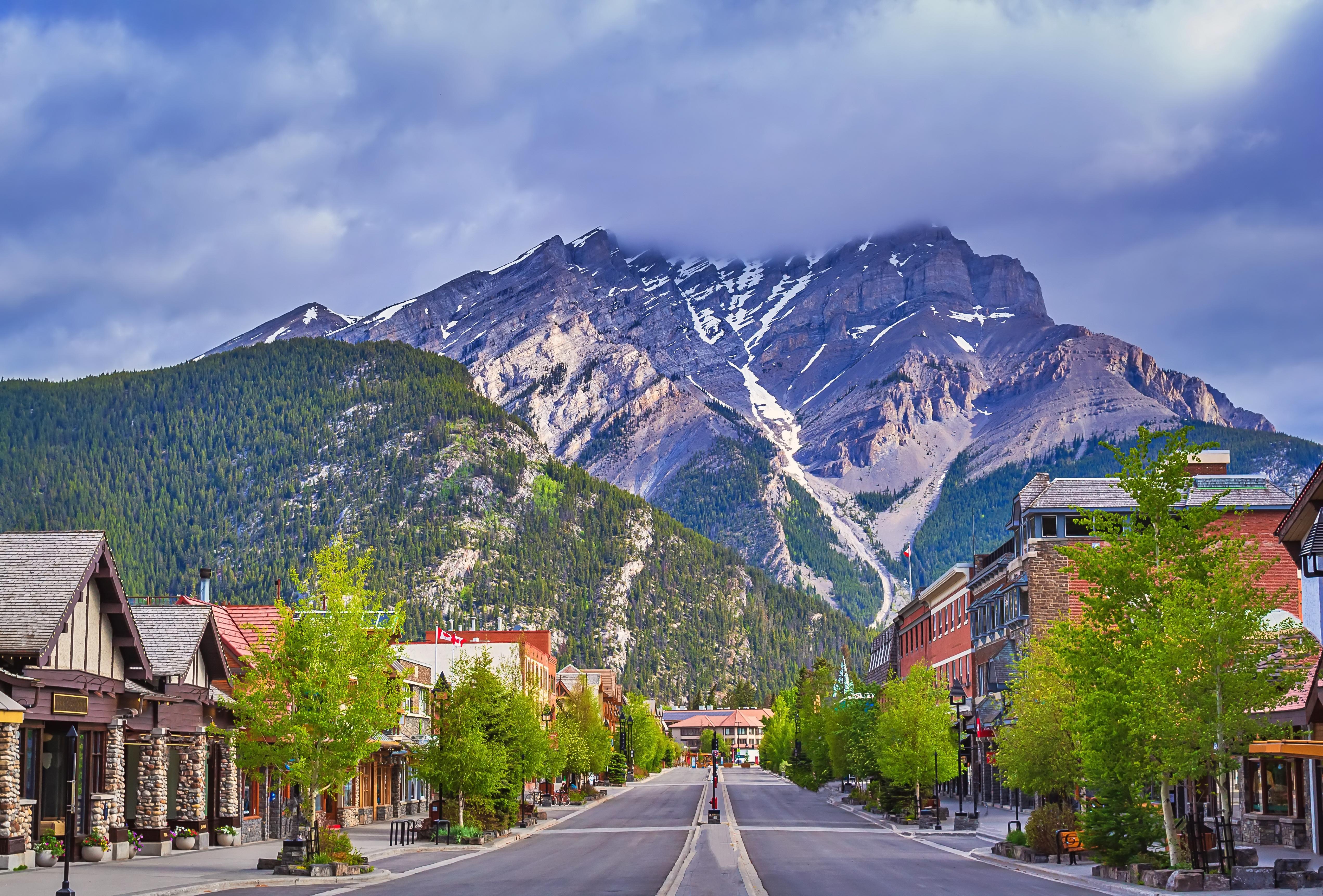
October 2-4, 2024 | Ban , AB
Gussow 2024: Montney Subsurface Evaluation: Drive Towards Excellence aims to showcase technical work across various geotechnical fields within the Montney Formation. With its potential as a secure national energy source, an economic asset for global companies, and a key resource in the energy transition, understanding the Montney subsurface is crucial. Gussow 2024 o ers attendees numerous opportunities to learn from and engage with peers from academia, industry, and government.
Register for Gussow 2024 today! Take advantage of Early Bird Rates until September 13, 2024. REGISTRATION OPEN
Elevate your brand by sponsoring Gussow 2024! Connect with industry leaders, and position your brand for success.
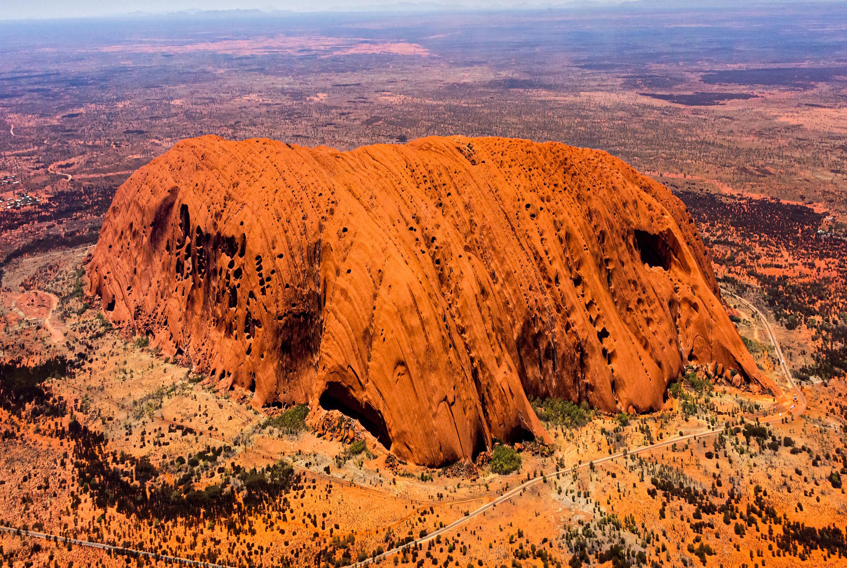
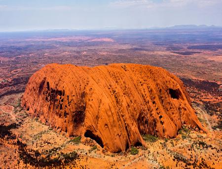
BEST SUB-CATEGORY PHOTO (AERIAL PHOTO): Uluru, Australia. Uluru, previously known as Ayers Rock, occurs in the southern part of the Northern Territory and is a sacred site to the Pitjantjatjara aboriginal people of the area. Uluru hosts a variety of springs, water holes, caves and ancient paintings. It is composed of Neoproterozoic to early Cambrian sandstones deposited in the Amadeus Basin in alluvial fans during erosion accompanying the Petermann Orogeny. These red-weathering arkosic sandstones of the Multitjulu Formation were uplifted and folded during the Alice Springs Orogeny (400-300 Ma) and have been eroded to form the present-day feature that is termed an inselberg. View to the south with bedding near vertical, strike 130 degrees with the youngest sediments on the right-hand side. Uluru was designated as a UNESCO World Heritage Site in 1987.
Photo by: S. Anne Reeckmann
SARAH SCHULTZ, TECHNICAL EDITOR FOR THE RESERVOIR
Time to dust off those rock hammers and hand lenses, get out and look at the outcrops that have been hiding under the snow.
CEGA has a lot of great events scheduled for this summer! There are multiple opportunities for CEGA Members to Go-Take-A-Hike throughout July and August. As well, the annual Golf Tournament will take place August 14, 2024. Please check the CEGA website for up-to-date information on these events and to register! Technical luncheons will resume in the fall, so keep your eye on the website to register for those events.
In this issue we present the continuation of our regular articles:
• Geology in Motion: The Effects of Warfare of Geology (Part 1: Bombturbation)
• From the Desk of the AER: The Core Research Centre and its Importance to Alberta’s Energy Industry (Part 1: The Facility)
• The Blue View: Industry Trends Through Woodmac’s Lens
In this issue we present the following technical articles:
• Jon Noad: Springbank’s Oncoids and the Crater of Doom
In this issue we recognize the recipients of the following awards:
• President’s Award: Benjamin J. McKenzie
• CSPG Hunter Award: David W. Middleton
• CSPG Hunter Award: Brenda Pearson
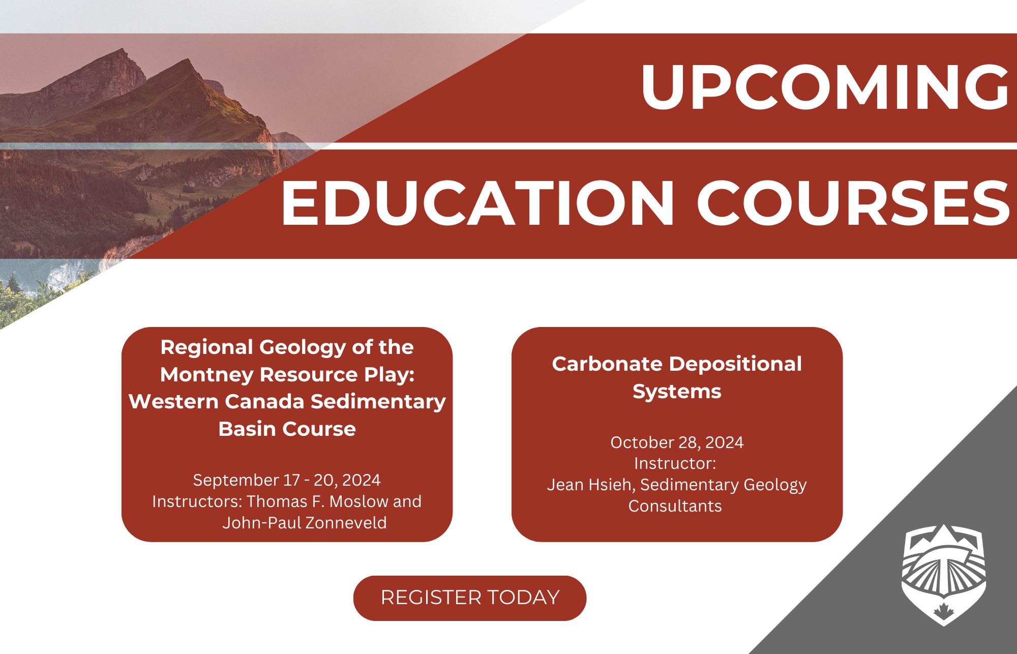
Early bird registration for the 2024 Gussow Conference ends September 13, 2024. This year’s theme is: Montney Subsurface Evaluation: Drive Towards Excellence.
We look forward to receiving your manuscripts for the upcoming issues of the CEGA Reservoir.
The RESERVOIR is published 6 times per year by the Canadian Energy Geoscience Association. The purpose of the RESERVOIR is to publicize the Association’s many activities and to promote the geosciences. We look for both technical and non-technical material to publish.
The contents of this publication may not be reproduced either in part or in full without the consent of the publisher.
No official endorsement or sponsorship by the CEGA is implied
for any advertisement, insert, or article that appears in the RESERVOIR unless otherwise noted. All submitted materials are reviewed by the editor. We reserve the right to edit all submissions, including letters to the Editor. Submissions must include your name, address, and membership number (if applicable). The material contained in this publication is intended for informational use only.
While reasonable care has been taken, authors and the CEGA make no guarantees that any of the equations, schematics, or
devices discussed will perform as expected or that they will give the desired results. Some information contained herein may be inaccurate or may vary from standard measurements. The CEGA expressly disclaims any and all liability for the acts, omissions, or conduct of any third-party user of information contained in this publication. Under no circumstances shall the CEGA and its officers, directors, employees, and agents be liable for any injury, loss, damage, or expense arising in any manner whatsoever from the acts, omissions, or conduct of any third-party user.

PRESIDENT
Andrew Vogan
ConocoPhillips Canada Ltd. andrew.vogan@cegageos.ca LinkedIn

FINANCE DIRECTOR ELECT
Rachel Lea
Suncor Energy directorfinanceelect@cegageos.ca

DIRECTOR
Scott Leroux
Mancal Energy Inc. education@cegageos.ca Linkedin
CEGA OFFICE
#150, 540 - 5th Ave SW
Calgary, Alberta, Canada T2P 0M2
Tel: 403-264-5610 | cegageos.ca

PAST PRESIDENT
Simon Haynes Haynes Geological Consulting simon.haynes@cegageos.ca

DIRECTOR
Gary Bugden
Cabra Consulting Ltd membershipdirector@cegageos.ca Linkedin

DIRECTOR
Michael Livingstone Eathie Consulting Limited technicaldivisions@cegageos.ca LinkedIn
PRESIDENT ELECT
Shelley Leggitt
Kiwetinohk Energy Corp. shelley.leggitt@cegageos.ca

DIRECTOR
Ross Kukulski
Chevron Canada publications@cegageos.ca

DIRECTOR
Michelle Thoms Freehold Royalties Ltd. outreach@cegageos.ca Linkedin
MEMBERSHIP INQUIRIES
Tel: 403-264-5610
Email: membership@cegageos.ca
ADVERTISING INQUIRIES
Britney Tang
Tel: 403-513-1230
Email: britney.tang@cegageos.ca

FINANCE DIRECTOR
Scott Norlin Wood Mackenzie directorfinance@cegageos.ca Linkedin

DIRECTOR
Marcelina Labaj
Central European Petroleum Ltd. fieldtrips@cegageos.ca Linkedin
DIRECTOR
Kevin Webb
Aquitaine Energy Ltd. conferences@cegageos.ca Linkedin
CONFERENCE INQUIRIES
Kristy Casebeer
Tel: 403-513-1234
Email: kristy.casebeer@cegageos.ca
MANAGING DIRECTOR
Emma MacPherson
Tel: 403-513-1235
Email: emma.macpherson@cegageos.ca

Warfare has not only shaped human history but also transformed the very ground beneath our feet. While battles are often depicted as clashes of armies and strategies, an often-overlooked factor in military operations is the influence of geology. From ancient times to modern conflicts, the terrain has played a crucial role, altering the course of history in profound and lasting ways. In any battlefield, understanding the land in terms of features, canalizing lanes, avenues of approach and obtaining the high ground provides a distinct advantage. In addition to the surficial features, military geologists have been tasked with characterizing the subsurface by drilling water wells, finding suitable building materials, evaluating substrates for military vehicles, and excavating tunnels. Many of these military applications have played a significant role in shaping the outcomes of wars throughout history. However, a related, and equally overlooked topic is the lasting effects of warfare on the terrain itself. This article, the first installment of this series, focuses on exploring unique examples of landscapes changed through warfare, specifically the impact that bombs have had on earth’s surface.
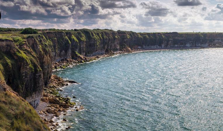
Pointe Du Hoc: Operation Overlord was the monumental invasion of German-occupied France, designed to turn the tides of WWII against the Nazis. Allied troops from the United States, Canada, the United Kingdom, and other countries stormed the beaches of Normandy on June 6, 1944 in what was the largest seaborne invasion in history. Army Rangers were tasked with taking a vantage point between Utah Beach and Omaha Beach on the top of a Cretaceous limestone cliff called Pointe du Hoc.
This prominent cliff-top position was heavily fortified by the German forces, and bristling with artillery and machine guns. Its elevated location provided a commanding view of the
surrounding coastline, making it a potential threat to landing beaches. American Army Rangers undertook a daring assault to scale the limestone cliffs with rope ladders and capture Pointe du Hoc. However, the main alteration to the landscape was caused by pre-invasion bombing by the 9th Air Force A-20 Havoc bombers. The heavy bombing left the area pockmarked with metre-scale craters, creating a terrain occasionally referred to as “Bombturbation” (Figure 1).
Tunneling in WWI and the Lochnagar Crater: Excavating and tunneling in WWI was a common practice (Doyle, 2014, Deiderichs and Hutchinson, 2021). Trench warfare is perhaps
the most well-known example of excavation in WWI, but tunnels through underlying bedrock were also commonly used to transport troops, supplies, and even to deliver explosives behind enemy lines. As discussed by Laycock et al. (2023), tunneling at Vimy Ridge provides an excellent example of the use of this tactic in WWI. The tunnels from that battle are still there, along with inscriptions from soldiers on the walls. The permanence of those excavations is debatable, as occasional collapses occur, and create hazards for visitors to the memorial at Vimy Ridge (Hutchinson et al. 2008).
The prelude to the deadly Battle of the Somme included extensive tunneling by both sides of the battle. The bedrock of the Somme is comprised primarily of relatively soft
chalk, which facilitated excavations (Figure 2). Tunneling under “no man’s land” was dangerous, as explosions from surface battles, or from adjacent enemy tunnels, could cave in the underground mining operations on the miners. Another risk was directly encountering the enemy’s tunnel, which could result in brutal hand to hand combat underground.
In 1916, the 185th Tunneling Company started work on the “Lochnagar” mine in November of 1915. The tunnel started approximately 91 m behind the British front line, which was only 270 m away from the German front line, reaching a total depth of around 29 m. Maintaining silence was a top priority for the miners, who feared being detected by enemy miners. They worked barefoot, using primarily bayonets to scrape away at the chalk, averaging only around 46 cm of progress per day (Edmonds, 1993). Eventually the mine was finished and was packed with 27 tons of explosives. On July 1, 1916, the first day of the Battle of the Somme, the explosives were detonated, creating a crater that was 140 m across and 30m deep (Sheldon, 2006).
Tunneling in WWI also has had a lasting geological impact in other ways. Early geophysical techniques were used to triangulate enemy artillery positions. They would also hold a geophone to their ears to listen for enemy tunneling operations (Gendzwill, 2007). Many craters from WWI were eventually filled in to reclaim the land, but the Lochnagar crater has been preserved to honor those who fought.
Project Plowshare: Perhaps the most extreme example of “bombturbation” is found in Nevada. Project Plowshare was a product of the Cold War, initiated in the 1950s by the United States Atomic Energy Commission, aimed to explore peaceful applications of nuclear weapons. Specifically, it focused on using nuclear devices for large-scale engineering projects, such as mining, excavation, and creating artificial harbors. The idea was to harness the immense energy released by nuclear explosions to reshape the Earth’s surface (refer to US department of energy report DOE/NV--209-REV 15). However, due to environmental and safety concerns, most of these plans were eventually abandoned, leaving behind a series of craters in the Nevada desert (Figure 4).
“Storax Sedan” was one such nuclear test, performed on July 6, 1962 using a
FIGURE 1: A) Cliffs at Pointe Du Hoc. Army Rangers were tasked with the dangerous mission of scaling these Jurassic-aged cliffs under enemy attack. B) Craters near the fortifications at Pointe Du Hoc show an example of “Bombturbation”.
FIGURE 2: Illustrated cross section of the generalized geology of the Somme region. Blue arrows show fighting trenches with favorable locations in terms of drainage, red arrows show trenches with poor drainage locations. Orange arrows show deep dogours with poor drainage, and purple arrows show deep dugouts with favorable drainage. The green arrows indicate the fighting tunnels in the chalk, which are those which would have been mined for detonation of explosives and delivering troops behind enemy lines.
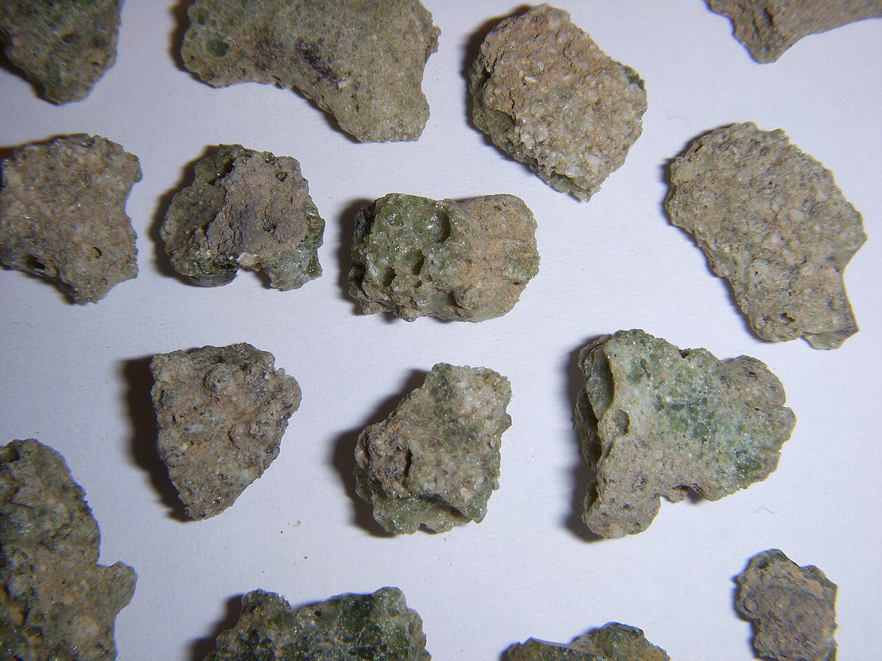
Trinitite: Trinitite is a unique glass-like substance first documented in the desert sand at the Trinity test site in New Mexico, where the world’s first nuclear bomb detonation occurred on July 16, 1945. The intense heat of the explosion, estimated to be around 1,470 °C (2,680 °F), melted the arkosic sand, resulting in the creation of a layer of green glass that is mildly radioactive (Eby et al. 2010). Initially green in color due to its composition, variations of trinitite include red, attributed to copper from the bomb’s electrical wiring, and rare black specimens. Trinitite itself has no crystal structure, and therefore does not qualify as a mineral.
The formation process involved sand being drawn up into the fireball, melting, and then raining down in a liquid form before resolidifying (Hermes and Strickfaden, 2005). The study of trinitite provides valuable insights into the effects of nuclear detonations on geology. Within the glass, unmelted quartz grains are encapsulated alongside radionuclides formed during the blast, offering a snapshot of the momentous explosion.
thermonuclear device, which was lowered into a 194 m deep borehole, drilled into the alluvium. The blast had a yield of 435 terajoules and displaced more than 11,000,000 tons of soil. The blast was powerful enough to create the largest man-made crater in the United States, measuring 390m in diameter with a depth of 98m. The surrounding area is also pockmarked with smaller craters from the
other 35 warheads detonated during Project Plowshare.
In the Soviet Union, atomic tests were conducted at the Semipalatinsk Test Site in northeast Kazakhstan. 456 nuclear tests were conducted, with severe impacts to the local population and environment. Satellite imagery reveals a terrain covered in craters, similar to that created by Project Plowshare in Nevada.
The interplay between geology and warfare is a multifaceted and often underappreciated aspect of military history. As explored in this article, the impact of bombs and other military activities have left indelible marks on the landscape, with physical and historical imprints
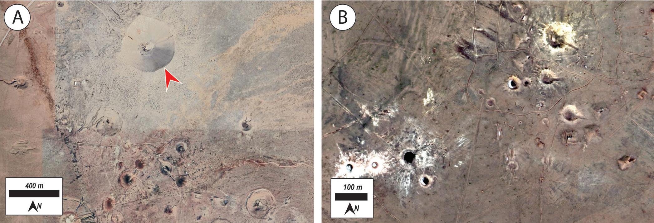
Figure 4: A) Google Earth image of craters from Project Plowshare in Nevada. The red arrow shows the Storax Sedan crater. Other smaller craters are visible toward the bottom of the image. B) Google Earth image of craters from similar nuclear bomb experiments in northeast Kazakhstan.
that endure long after the conflicts have ended. At Pointe du Hoc, the fierce D-day battle scarred the cliffs, leaving craters and remnants of the fortifications that bear witness to the conflict. The massive explosion at Lochnager mine during WW1, resulting from extensive strategic tunneling, permanently transformed the landscape, creating a vast crater that stands as a testament to the subterranean warfare in the area. Project Plowshare’s experimental
nuclear explosions, intended to test application for peaceful engineering and construction had significant geological impacts, illustrating both the potential and peril of using such powerful forces and the alteration that can occur to the Earth. Trinitite, formed by the intense heat of the first nuclear test at New Mexico’s Trinity site, symbolizes the profound and sometimes unintended consequences of human actions on the Earth’s surface. The huge force and
Deiderichs, M., Hutchinson, D.J. (2020). Tunnel Warfare in World War I: The Underground Battlefield Tunnels of Vimy Ridge, France. Published in Tunnels and Underground Cities: Engineering and Innovation Meet Archeology, Architecture and Art, Volume 1. p. 52-61.
Doyle, P. (2014). Geology and the war on the Western Front, 1914–1918. Geology Today. Vol. 30, No. 5. Pages 183-191.
Eby, N., Hermes, R., Charnley, N., Smoliga, J.A. (2010). Trinitie – The Atomic Rock. Geology Today, Vol. 26, No. 5. P. 180-185. Edmonds, J. E. (1993). Military Operations France and Belgium, 1916: Sir Douglas Haig’s Command to the 1st July: Battle of the Somme. History of the Great War Based
on Official Documents by Direction of the Historical Section of the Committee of Imperial Defence. Vol. I. P. 36, 371.
Gendzwill. D. (2007). Vimy Ridge and Geophysics. CSEG Recorder, June 2007, Vol. 32 No. 6.
Hermes, R., Strickfaden, W. (2005). New theory on the formation of trinitite. Nuclear Weapons Journal, No. 2, p. 2-7.
Hutchinson, D.J., Diederichs, M., Pehme, P., Sawyer, P., Robinson, P., Puxley, A., Robichaud, H. (2008). Geomechanics stability assessment of World War I military excavations at the Canadian National Vimy Memorial Site, France. International Journal of Rock Mechanics and Mining Sciences. Vol 45, No. 1, P. 59-77.
FIGURE 5: Image of trinitie samples. The original image did not include a scale, but the fragments range in size from approximately 1 to 3 cm in diameter. Image courtesy of Shaddack - CC BY 3.0, https://commons.wikimedia.org/w/ index.php?curid=5935485
energy exerted in the discussed examples have reshaped associated landscapes and altered natural processes in ways that underscore the intricate linkages between anthropogenic activity and geological processes. Future installments in this series will delve deeper into the effects of warfare on geology related to flooding and sedimentology.
Laycock, D.P., Fletcher, S., Pemberton, E., Bremner, P., Mackenzie, R. (2023). Geology in Motion: The Geology of the Battle of Vimy Ridge. CEGA Reservoir 2003 No. 6. P. 26-31.
Rosenbaum, M.S. (1989). Geological Influence on Tunnelling Under the Western Front at Vimy Ridge. Proceedings of the Geologists’ Association. 100 (1). P. 135 – 140.
Sheldon, J. (2006). The German Army on the Somme 1914–1916 (Pen & Sword Military ed.). London: Leo Cooper. ISBN 978-1-84415-269-8.
United States Nuclear Tests; July 1945 through September 1992, DOE/NV--209-REV 15 December 2000
SEPTEMBER 26, 2024
Bow River Pathway 6:00 pm - 9:00 pm
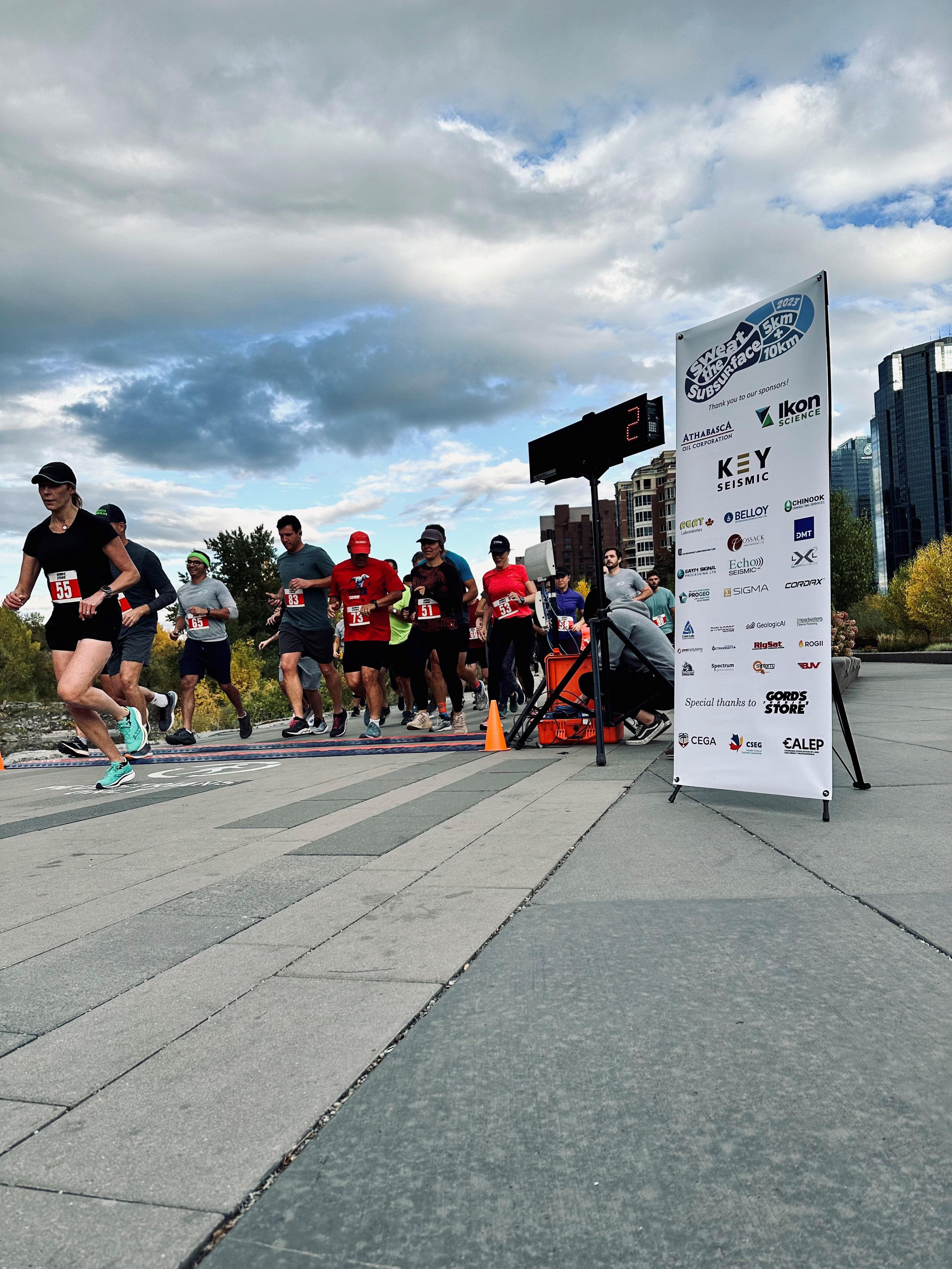
Sweat the Subsurface Road Race and Fun Run/Walk is an annual event that brings together participants from the geoscience community and beyond for a fun and competitive running experience. The CEGA/CALEP/CSEG collaborative event offers several race distances to accommodate participants of all skill levels, including a 5K and 10K.
SPONSORSHIP OPPORTUNITIES AVAILABLE
We're seeking sponsors for the Road Race and Fun Run/Walk! This is a fantastic opportunity to showcase your brand and connect with our community.
Click the button to register for this race, learn more about the tournament and sponsorship opportunities.

The President’s Award is CEGA’s most prestigious form of volunteer recognition. It is presented by the CEGA President at the end of their term to a recipient who has provided exemplary leadership in a variety of roles and capacities that the contributions to association programs and events such that this award often provides a milestone in a distinguished career of sustained, exemplary membership.

Ben joined the CSPG as a member in 1982 and has served our organization through to the present day in numerous roles. In 1992, on behalf of the CSPG, he began compiling and arranging to publish a series of detailed correlation charts for Alberta. In 1993, in response to one of the industry’s downturns, he and a group of other CSPG members produced a consultant directory as a way to advertise members’ expertise. In the mid-90s to mid-2000s, he worked with the Canadian Gas Potential Committee (which began as a CSPG committee) in a variety of data management, GIS, technical writing, and editorial roles for each of their three reports.
In 2003 Ben became the Technical Editor of the Reservoir magazine. At that time, there was debate over the viability of the Reservoir. For over a decade, Ben rose to the challenge of editing, coordinating publication efforts and volunteers, and contributing numerous technical articles. Under his guidance the Reservoir flourished to become the pre-eminent method by which the CSPG communicated with its members.
Ben also took on the position of Committee Chair for the Digital Atlas Committee in 2009. Working closely with ESRI and other committee members, Ben developed a ‘proof of concept’ web-based geological atlas. A harbinger of things to come, a demonstration of this product was presented during the GeoCanada 2010 convention. Ben passed the reins of the Reservoir off in 2013 but didn’t rest on his laurels as he stepped up to be one of the contributors to and editors of the CSPG’s “Go Take a Hike”, a series of short geologically focused day hikes in memory of Dr. Cynthia (Cindy) Riediger. The volume was published in 2019 and remains one of CSPG’s bestselling books.
In 2020, Ben and several other volunteers recognized the need to update and expand the seminal “Geological Atlas of the Western Canada Sedimentary Basin”, which was originally published in 1994. Like the original Atlas, this version involves the efforts of over 200 volunteers. Ben plays a key role as chair for the Technical Services Committee, whose mandate is to oversee all aspects of the mapping processes, data management, and publication design and production needed to produce the Atlas by mid-2027. Ben is also on the Atlas Steering Committee, which provides high-level direction to other committees throughout the planning, execution, and delivery of the Atlas 2027 publication.
Ben exemplifies the best qualities and personal demeanor of a CEGA volunteer. Respectful, helpful, diligent, and with a strong sense of duty and humor, he is a consummate gentleman and professional. Ben is on of the “quiet volunteers” who operates out of the limelight, but whose long-term sustained efforts have significantly strengthened our organization.
Kerry Murphy and Eric Timmer
The Alberta Energy Regulator (AER) Core Research Centre (CRC) is an unassuming 200,000 square foot facility located in the University of Calgary Research Park (Figure 1). For over 60 years, the centre has been storing drilling data and providing viewing access to the public. Today it is home to one of the largest collections of geological samples in the world, with the oldest drilling core dating back to 1925. Its collection has stimulated Alberta’s oil and gas industry for decades. In a recent interview one CRC stakeholder expressed, “The success of the province is tied to the knowledge at the CRC”. Herein we present Part One of a Two Part series dedicated to the facility and how it has been used by geoscientists, including many CEGA members, over the decades.
With the AER’s expanded mandate into critical minerals, carbon capture, utilization, and storage (CCUS), brine hosted minerals, geothermal, and other developments the collection will without a doubt once again prove to be a valuable data asset for the province. In fact, the value of its data has already been widely recognized with its vast contributions to the Alberta Geological Survey (AGS) Mineral Mapping Program (information on this program can be found at ags.aer.ca).
However, this isn’t the first time the CRC historical drilling core data has proven to be an asset. Back in the early 2000’s it helped facilitate the shift from conventional play types to unconventional shales, clastics,
carbonates, and was used to identify subsurface intervals for storage and disposal of CO2, contaminated water, and tailings.
Just a few years before industry started to explore unconventional resources in western Canada, the facility had reached its storage capacity and the regulator had leased an expensive secondary storage location. With the fixed operating costs of a building this size during tight financial times the AER had to consider strategies for storage including the culling of core that did not seem to be of interest to industry (e.g., rare cores through shale and tight intervals). Fortunately, culling did not proceed because the “low-interest” core subsequently proved critical to unlocking billions of dollars of revenue for Alberta as
the new era of unconventional resources dawned. One of the key lessons from this transition was that aging data does not lose value, but if you destroy it, you may never know the value it could have had.
Fast-forward to today (Figure 2), and once again we find ourselves in a position where we are at capacity and looking at strategies to manage storage and viewing access for our geological collection. However, this time we have historical evidence and data to prove the ‘Value of Core’ to an ever-transitioning energy landscape.
In addition to industry geoscientists, the CRC has been a centre for academics and students from Alberta, across Canada, the U.S. and internally, conducting studies that have
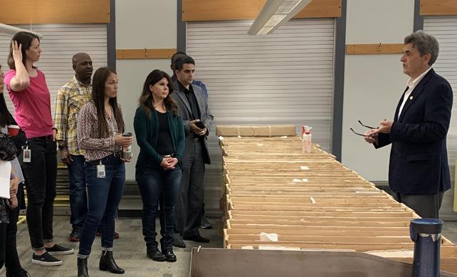
Dr. John Weissenberger, a long-time patron of the CRC and current Vice President, Technical Science and External Innovation at the AER, describing core samples for his team.
contributed significantly to Alberta’s oil and gas industry. Stakeholders see a tremendous value in seminars and workshops held at the CRC due to the ability to view physical core holdings in conjunction with in-class learning. It also hosts the annual Canadian Energy Geoscience Association (CEGA) Core Conference which brings in patrons and delegations from Alberta and around the globe.
Aside from its contributions to the exploration and development of oil and gas resources there are many other interesting things found at the CRC from time to time. As you can imagine, with such a vast collection it isn’t
Lukus Wagstaff, CRC Compliance and Operations Technologist with his discovery of core and drill cuttings preserved in vintage oil cans.
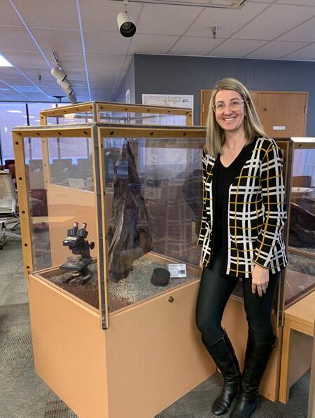
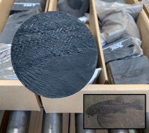
Cool things at the CRC. A. Fossil of an Albertonia cupidinia discovered in a core sample at the CRC (Inset image: full fossil of extinct species for reference). B. Ashley Moisson, Manager, CRC Customer Service & Operations by the display case containing the core slab with the Albertonia cupidinia fossil in the CRC lobby. Additional fossils are on display.
uncommon to discover some interesting gems. Recently, a CRC Compliance and Operations Technologist, while opening core boxes from the late ‘50’s discovered an operator had used motor oil cans to store drilling samples (Figure 3).
With nearly 85 million metres of drilling core(!) stored at the CRC there are bound to be treasures and of course fossils to discover.
A recent discovery (Figure 4A) was a fossil of Albertonia cupidinia, a species of fish that lived in the waters of Alberta during the Triassic Period (about 250 million years ago). The fossil is now on display in the CRC lobby (Figure 4B).
It’s evident there’s lots of history, data, and knowledge about Alberta stored at the CRC whether it lies within the millions of core boxes, the staff, or the patrons. One thing is for sure, it is impossible to describe exactly how valuable the collection is to the evertransitioning energy developments around the world. In Part Two of this series, we will mine our usage database to reveal various trends over time – which plays and cores have been of the most interest – and various other interesting aspects that help to demonstrate how geoscientists have used and benefitted from the CRC and its holdings.

David has served for multiple years as a CSPG volunteer on both technical and social event committees and the CSPG Executive in his 36 years of membership with CSPG/ CEGA. After several sessions working as a field trip coordinator with various joint AAPG/ CSPG conventions in Calgary, he embraced volunteering his skills to the local geological society. This was after extensive efforts with his local community association (various roles, culminating in President 1996 – 1998), coaching girls Fastpitch Softball, while being VP & League Director with Calgary Minor Softball 1992 - 2002. David volunteered with the CSPG Mixed Golf committee from 2001 – 2009 in multiple roles, was the inaugural CSPG Outreach Director from 2004-2007 and a committee member of the CSPG Geomodelling Committee from 2003 – 2009. He stepped back due to an overseas assignment with PetroCanada Oil & Gas in Libya from 2009 – 2011, but upon his return, rejoined the CSPG Mixed Golf committee and then assumed the co-chair duties with Brenda Pearson in 2012. David has benefitted greatly in working with many of the dedicated past chairs (Dick Willott, David Caldwell, and co-chair Brenda Pearson, and the awesome committee members and CEGA staff that have supported the Mixed Golf social event. The Mixed Golf tournament committee, sponsors and participants are happy to have supported the Trust and Outreach activities with over $20K in donations over the last 10 years of the tournament.
David had more than 39 years of varied technical responsibilities with Petro-Canada / Suncor Energy, after studying at the University of Calgary and Southern Alberta Institute of Technology in Geology /Geophysics. His work began in core description and led to running the Sedimentology and X-Radiography lab at Petro-Canada Exploration Research Lab by the University of Calgary in the 1980’s, and from there he was assigned to the Petro-Canada Frontier Exploration team as a Technologist, and due to natural curiosity and a strong computer background, specialized in computer aided exploration systems and ended up as Geological Systems Coordinator. Delving further into the geoscience application space, David focused on integrated modeling using specialized reservoir modeling software, and developed skills in geostatistical subsurface modeling. This experience led to projects and mentoring staff in Petro-Canada / Suncor in developing skills and best practices for geological modeling in conventional oil & gas projects in Western Canada, Mackenzie Delta, Arctic Islands, and offshore East Coast and International developments and an eventual two year secondment with a Libya joint venture partner, Harouge Oil Operations in Tripoli, Libya. David was involved in the planning and the lift & shift of the geoscience applications portfolio to a cloud based systems and ended his career with Suncor in the Geoscience Specialist team with the role of Senior Digital Integration Advisor, where he relished the opportunity to develop & implement new technologies to assist the subsurface teams. Now enjoying his semi-retirement, he now focuses on family, and plans to approach both his golf game and mountain biking with fun & laughter while staying involved in CEGA, developing some consulting ideas and enjoying retirement life.
Brenda Pearson first became involved in the CSPG on a volunteer basis in order to meet more people. The most fun way to do that, in her opinion, was to get involved in sporting events. Brenda played in the squash tournament, the hockey tournament, the mixed golf tournament and participated in the fun run. Brenda was invited to be part of the squash committee and from there it all started. After serving on the squash committee, she then served on the Mixed Golf and Classic Golf committees. Brenda also served on the Classic Golf committee for a handful of years but have been part of the Mixed golf committee for more years than she can count. Brenda been fortunate to have worked alongside David Middleton since 2012 in Mixed Golf. She believes it has been a great way to meet people and be part of events where people can relax and have some fun.
Outside of industry, Brenda volunteer for Curling Alberta, Special Olympics, and various community events. Brenda has enjoyed a fulfilling and challenging career with a variety of companies, both big and small. Now retired and taking advantage of every minute of it!
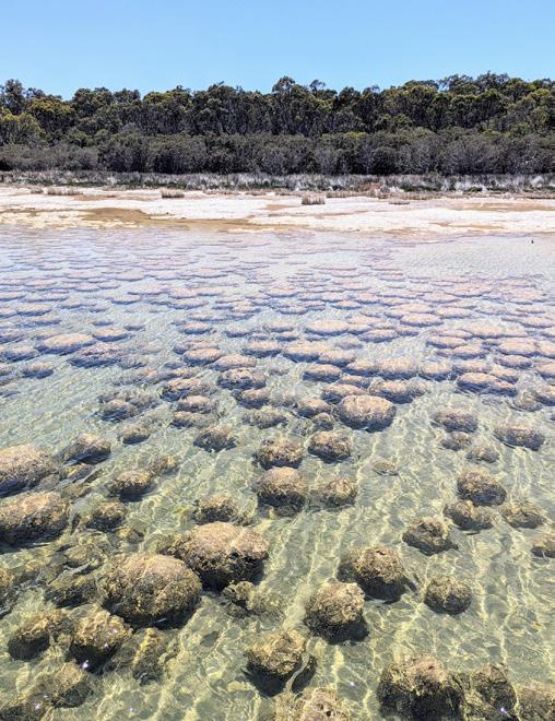
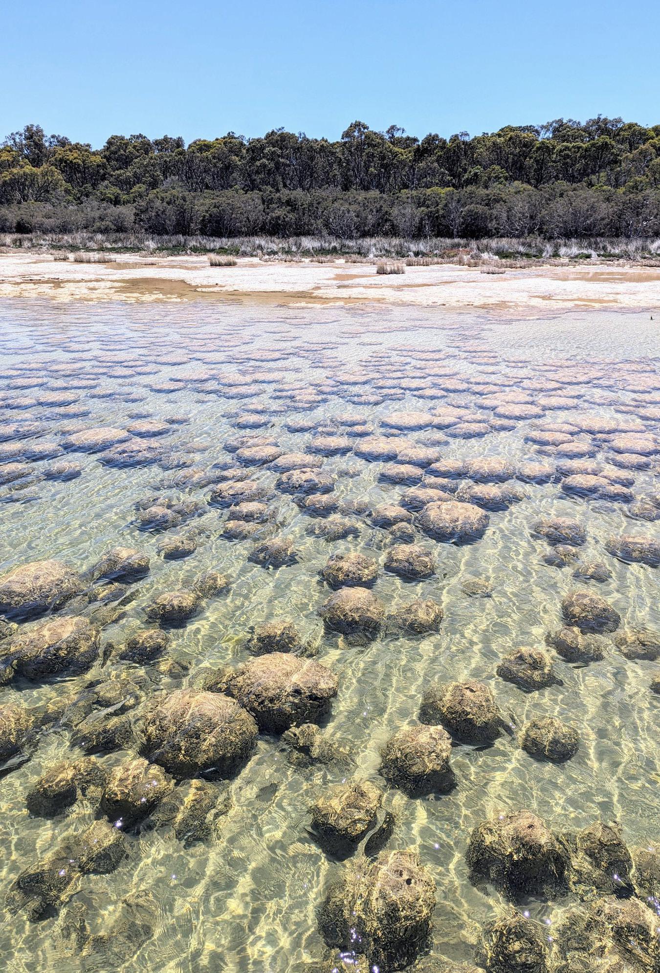
Oncoids are relatively common in the fossilrecord,particularlyinwarm,coastal and lacustrine carbonate settings (Figure 1.1). They are layered, carbonate structures formed by cyanobacterial growth, typically rounded to oblate and ranging in size from 2 mm to more than 10 cm in diameter. They often form aroundanucleussuchasashellfragment or clastic grain. Oncoids are usually indicators of warm, shallow marine to tidalwaterswithinthephoticzone.
Armed with this knowledge, one would NOT expect an extraordinary bed of oncoids, some reaching more than 20 cm in size, to occur within a thick, clasticdominated, Cretaceous to Paleocene fluvial succession exposed at the Springbank Off-Stream Reservoir (the Project; SR1) in Alberta, Canada. The 30 cmthickbedwasexposedduringongoing excavations associated with the construction of flood defences for SR1. The big question is…. what does this anomalousoncoidbedrepresent?

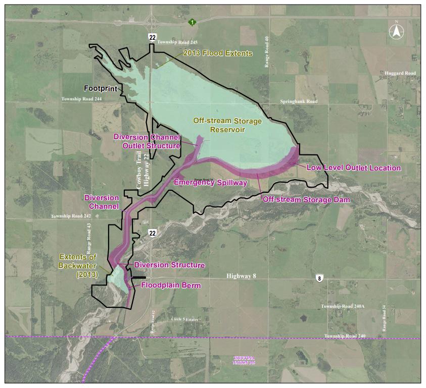
TheElbowRiverfloodof2013wasadevastating environmental event that caused significant social and economic damage to the City of Calgary and surrounding communities. In response, the Government of Alberta (Alberta Transportation and Economic Corridors) began construction of the SR1 Project to mitigate the impact of future floods. The SR1 Project is situatedapproximately15kmwestoftheCityof
Calgary on lands adjacent to the Elbow River (Figures 2.1, 2.2). The proposed SR1 Project designplanunderwentmeticulousconsideration, with the selected design chosen to minimize ecologicalandhistoricalimpactbypreservingkey routes and integrating existing infrastructure. Alberta Transportation and Economic Corridors have received project approvals for SR1 constructionandareworkingcollaborativelywith
theindigenousgroupsengagedontheprojectand the scientific community to manage the preservation of heritage resources, including supporting monitoring programs for the discovery ofsignificantpalaeontologicalresources.
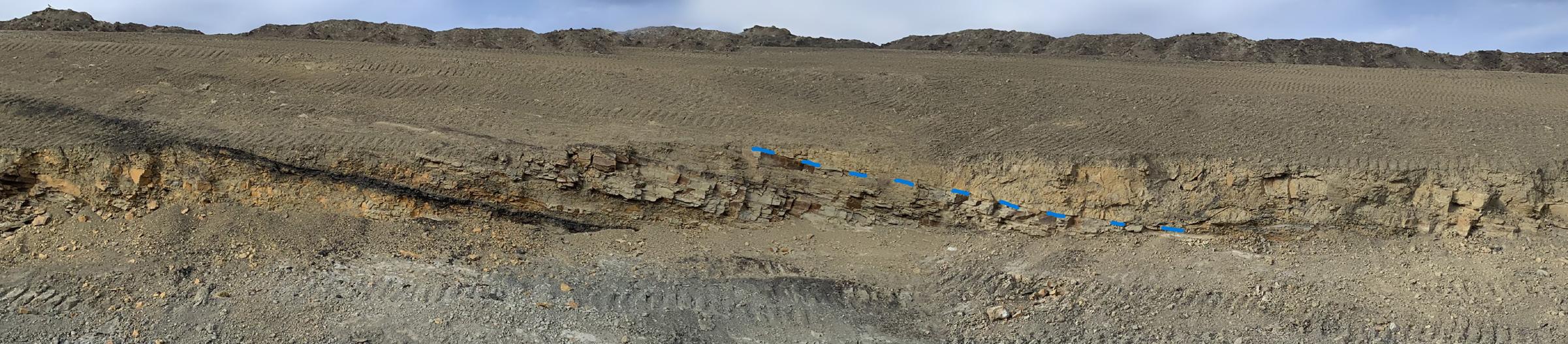
Large-scale excavations at SR1 were initiated in 2022 after federal and provincial environmental (impact) assessments were completed. The project site is located within the Rocky Mountains triangle zone,(4) and the southwestern portion of the site is cut by several fault zones, possibly associated with the Brazeau Thrust Fault, which extends 375 km southward from Hinton, AB.(5)
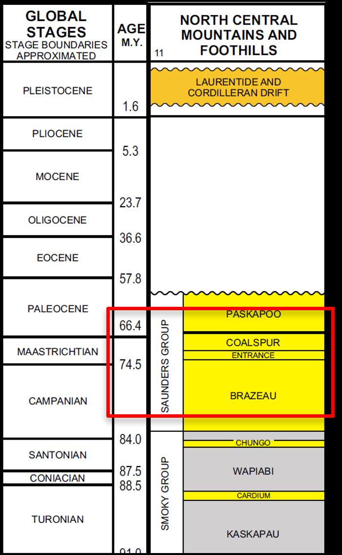
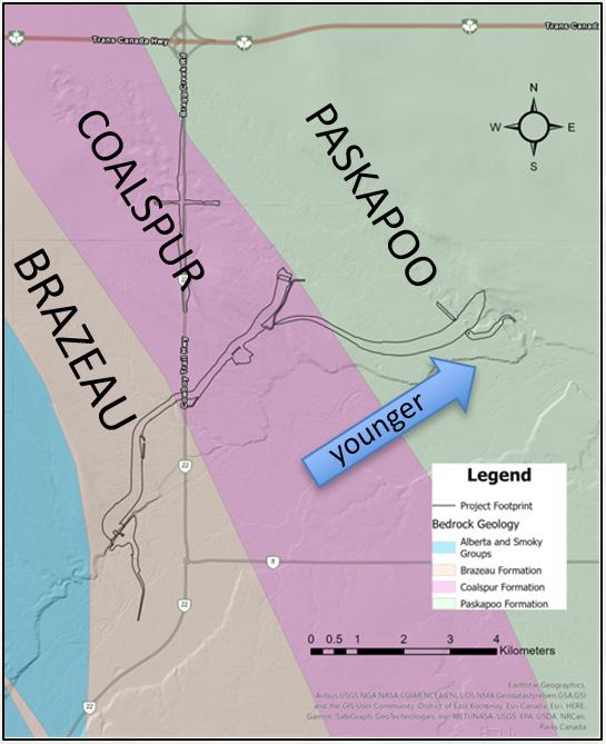
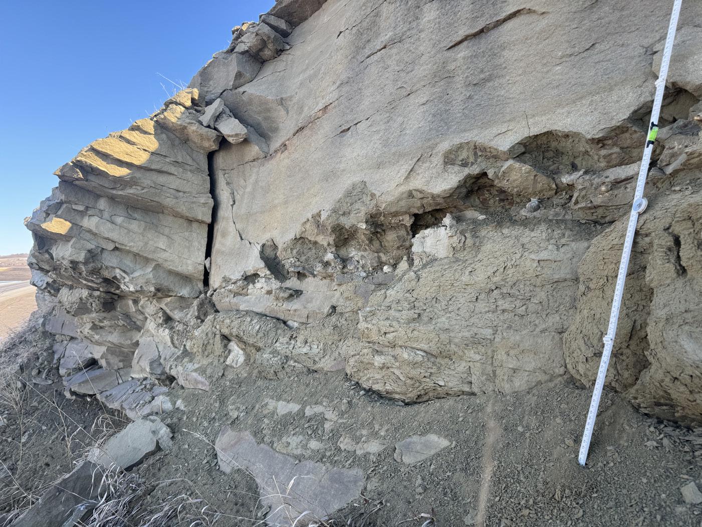
The excavations exposed two formations (Figures 3.1, 3.2): the Cretaceous Brazeau Formation and the Cretaceous to Paleocene Coalspur Formation, with an estimated total stratigraphic thickness of 900 m. At the site, the Brazeau Formation is dominated by thick, terrestrial mudstone deposits with interbedded thin, meandering channel sandstones (Figure 3.3). It featured one previously unrecorded marine incursion near the base of the exposed bedrock section,
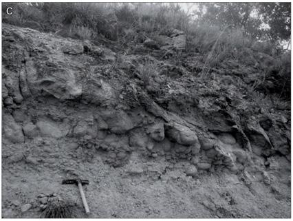
evidenced by a 2 m thick oyster bed (Figure 3.4) and associated ammonite remains. The Brazeau was cut by several fault zones, possibly associated with the Brazeau Thrust Fault, which extends 375 km from Hinton, AB, and was mapped as passing through the site (6).
The Brazeau Formation was capped by the thin Entrance Conglomerate (Figure 3.5), overlain in turn by the Coalspur Formation. The contact can be viewed in a roadcut on Highway 22, just south of the junction with Township Road 244 (Springbank Road). The muddy Brazeau Formation contrasted with the stacked sandstone beds of the basal Coalspur Formation, which reached 30 m in thickness. The sandstone interval was overlain by approximately 320 m of interbedded mudstones and sandstone beds, interpreted from new exposures and from borehole data gathered during the Project.
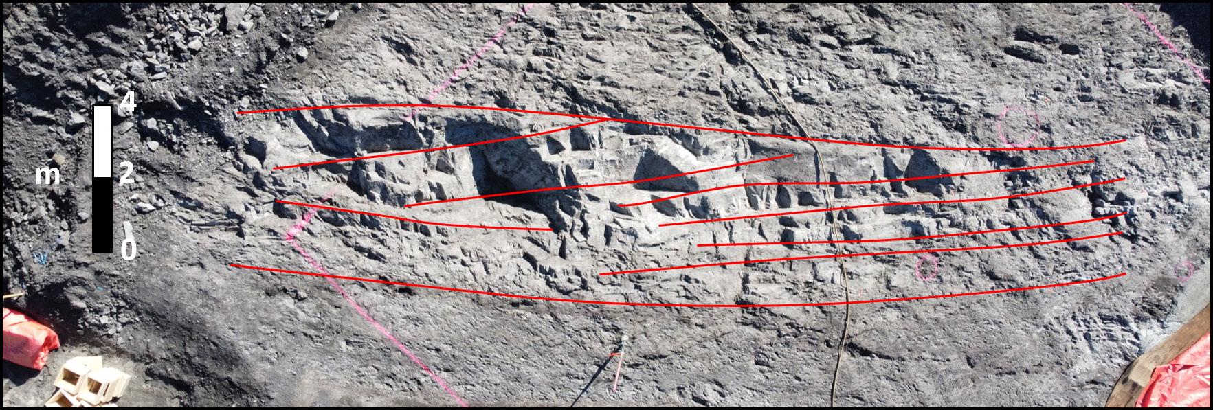
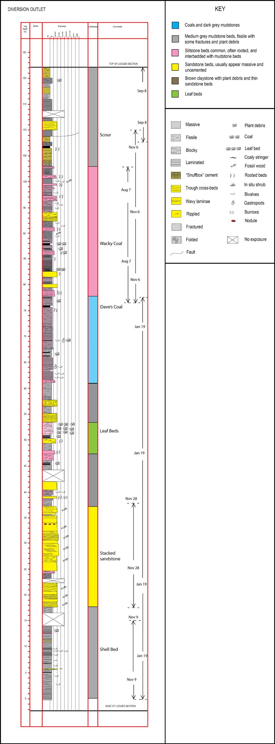
Half a kilometre to the northeast of the basal Coalspur sandstone beds, excavations for the Diversion Outlet exposed 125 m of continuous section (Figure 3.6) within the Coalspur Formation, comprising interbeds of mudstone, siltstone and sandstone beds. The sandstone beds had trough cross-beds near the base, often capped by dm bedded lateral accretion surfaces, interpreted as meandering channel deposits. There were often unionid lags (freshwater bivalves) at the bed bases. These channel deposits were interbedded with thick, cemented siltstone beds with abundant fossil plants including roots and occasional leaf beds. There were also thick mudstone beds with gastropod-dominated shell beds. The finer grained deposits are interpreted as overbank deposits and shallow lacustrinesediments.
Stantec was contracted to undertake palaeontological monitoring of excavations at SR1 based on the requirements of the Alberta Heritage Act, created in 1973 (7). The Act, along with the Historical Resources Act, serves to protect both archaeological and palaeontological historical resources through a variety of mechanisms. A "palaeontological resource" means a work of nature consisting of, or containing, evidence of extinct multicellular beings and includes those fossils designated by the regulations as palaeontological resources. In practice, this means daily monitoring visits to the SR1 Project by a qualified palaeontologist to examine all Project related excavations defined as having the potential to yield significant fossils.
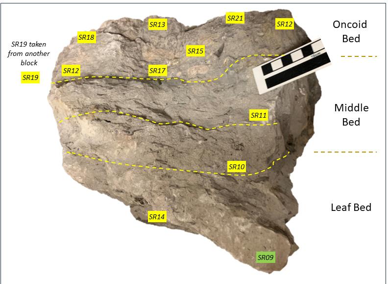
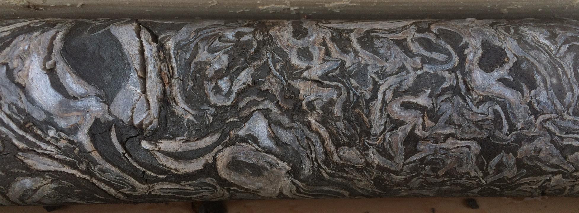
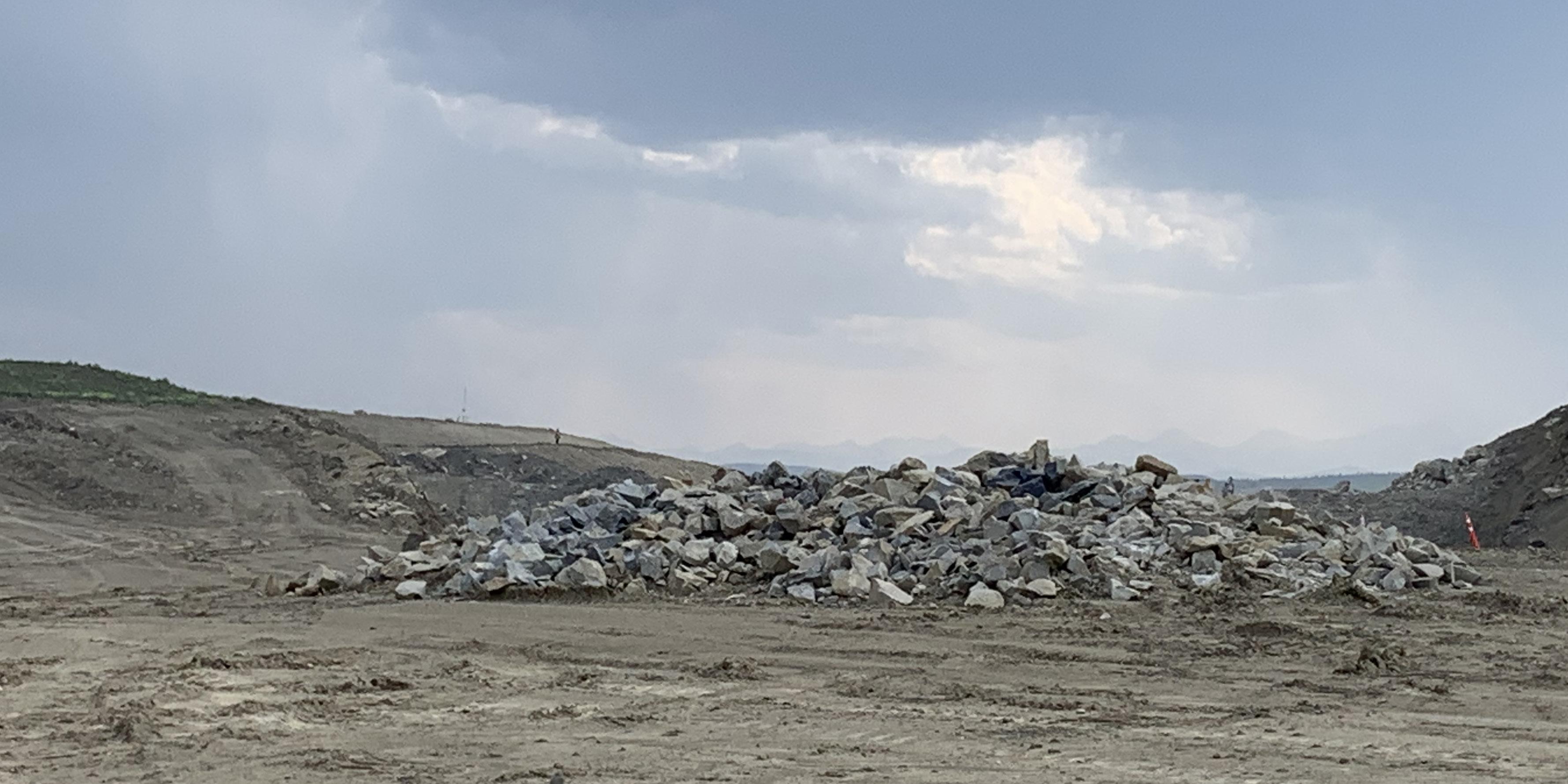
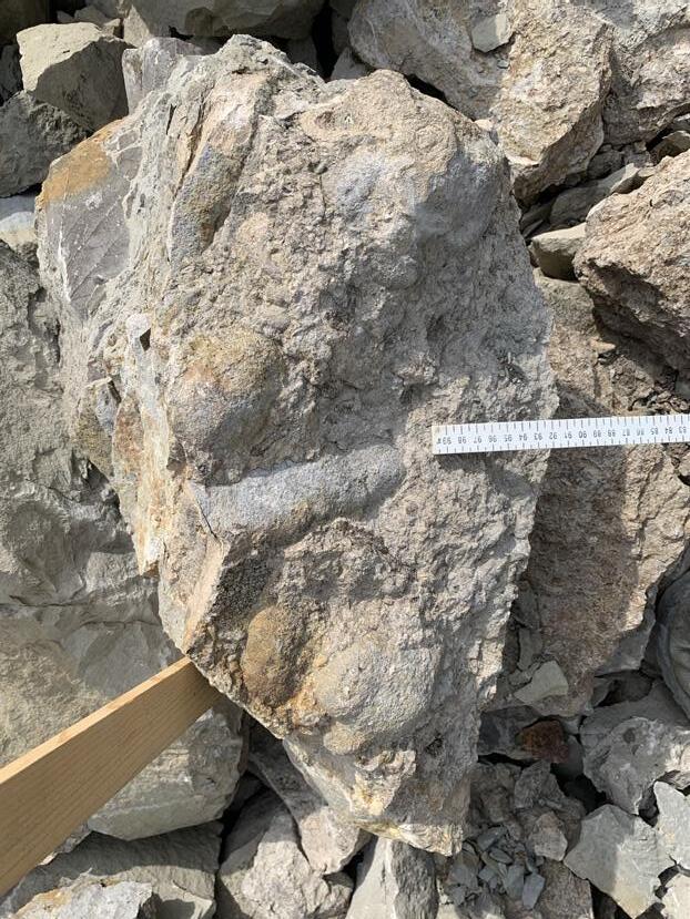
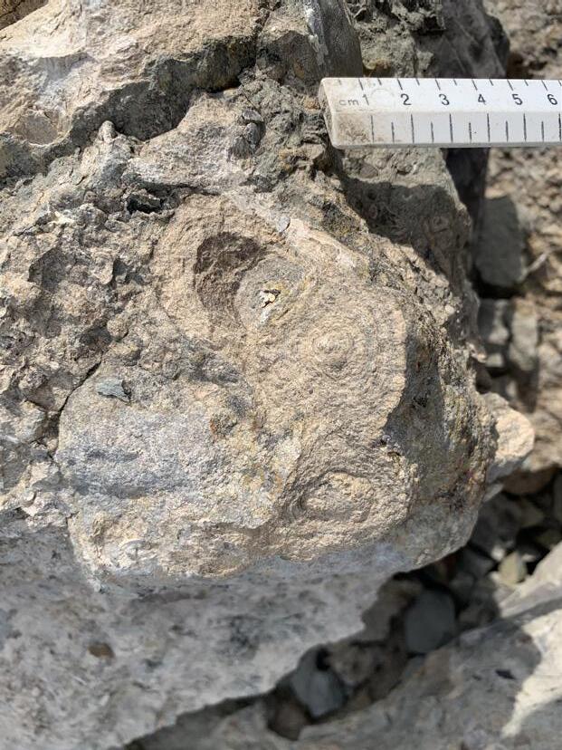
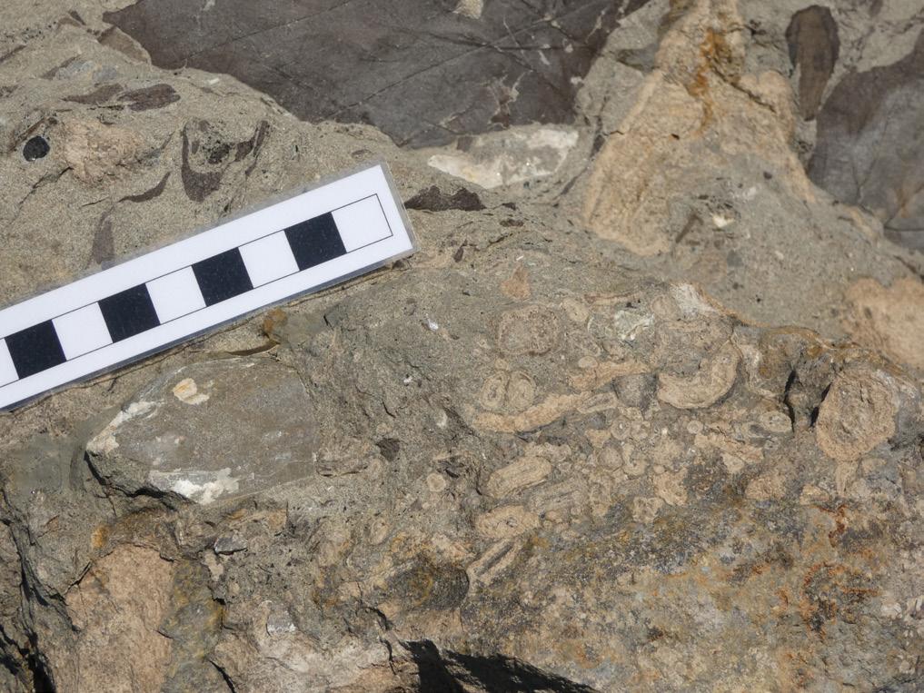
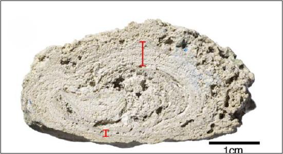
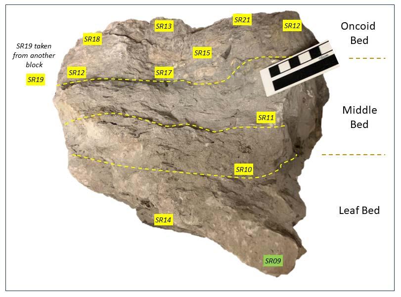
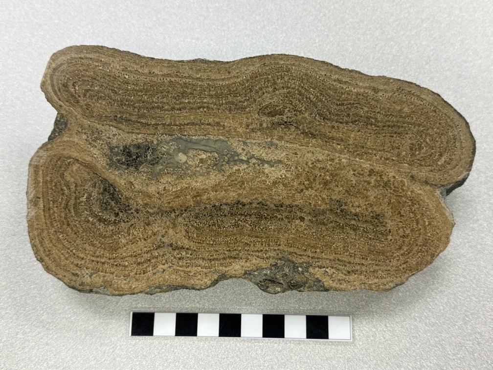
The author arrived on site on May 21st 2023, and found a new spoil pile (Figure 4.1) had been created from material excavated in the Diversion Outlet, which is located to the east of Highway 22. Examination of the boulders, most of which were over a metre in size, identified several sizeable blocks containing very large oncoids, some more than 20 cm in diameter (Figure 4.2) with well defined concentric laminae (Figure 4.3).
Discussion with the hoe operators allowed the approximate mined horizon to be narrowed down to a 10 m interval at around 108 m on the logged section (Figure 3.5). It is believed that the precise horizon may overlie the scour (marked by a dashed blue line) shown on the photomosaic in Figure 4.3. Unfortunately, the original outcrop had been fully excavated and the oncoids were not observed in situ.
Summary section through the Diversion Outlet, SR1 Project
FIGURE 4.1 New spoil pile in the Diversion
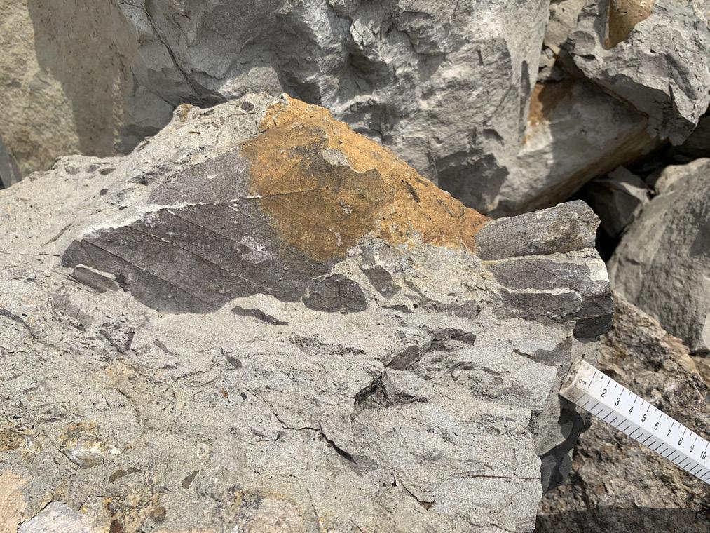
The succession seen in the boulders had a basal sandstone bed, termed the Leaf Bed, with fossil leaves up to 20 cm in length (Figure 4.5) and occasional unionid bivalves. These leaves are typical of the Coalspur Formation and include Platanites sp. of the sycamore family (pers. comm. Dr. Christopher West, Royal Tyrrell Museum of Palaeontology). This bed was overlain by another sandstone bed, the Middle Sandstone Bed, that ranged in thickness from 12 to less than 5 cm in thickness. The Oncoid Bed incised into this sandstone with large oncoids on the basal scour surface (Figure 4.2), overlain by abundant small oncoids ranging from 2 to 25 mm in diameter (Figure 4.6). The Oncoid Bed was approximately 15 cm in thickness.
where the oncoids were sourced
The sedimentary succession exposed at the SR1 Project in Springbank is estimated to be at least 600 m in thickness, comprising interbedded (terrestrial) clastic deposits over around 99.6% of the total thickness. The only exceptions recorded are the oyster bed, identified in the middle Brazeau Formation (interpreted as a Cretaceous marine incursion), and the Oncoid Bed in the middle Coalspur Formation, both of which have a hybrid, carbonate-clastic matrix. Oncoids of this size have not previously been recorded in Cretaceous clastic deposits in Alberta, which triggered a literature search to identify other examples of freshwater oncoidal deposits. Analogues were identified in both lacustrine and fluvial settings, in modern and ancient deposits.
Oncoids have been found in recent lake deposits in Michigan marl lakes (8,9) and in ancient lacustrine sediments (10,11), usually occurring in limestone beds (12). Typically, they are favoured in settings where the waters are calcium-enriched, and the terrigenous sediment supply was slow (13). Unusual geochemistry is common, with high dissolved solids and mineral concentrations such as sulphates (14).
Cretaceous to Eocene, shallow, active waters at the mouths of streams debouching into lakes may have led to oncoid deposition in the Flagstaff Formation in Utah (13). The Cretaceous Cedar Mountain Formation of Utah has dinosaur bones coated by bacterial mats, formed on a lake shoreline affected by fluctuating lake level (15). The asymmetrical laminations and irregular shapes of the oncoids suggests that the oncoids formed in place. Both lacustrine and fluvial Eocene deposits of the Ebro Basin contain oncoids (16), with the lacustrine deposits dominated by limestones, while the fluvial oncoids suggest channel flow. The associated laminated crusts are thought to relate to the low-discharge and ponding phases of the lake.
Some authors consider that a supersaturation state of calcium carbonate in waters and the presence of aquatic vegetation are essential to allow oncoidal growth (17,18). These carbonate fluvial systems are related to extensive surface and/or underground carbonate successions, and modern oncoids in fluvial setting have been reported from French streams in calcareous settings (19). Associated plants allow sites for calcite nucleation and precipitation. Oncoids may also be washed together as a channel lag (17) or preserved on wide, low gradient floodplains (19,20). A low sediment load and little dissolved charge may also promote oncoidal growth (21).
Spectacular modern, freshwater oncoids reaching 9 cm in diameter were reported from the river Alz in Bavaria (22,23). They grew in situ, without being overturned, and the bottom sides of the oncoids had thinner laminae (Figure 5.1). The river was mildly polluted and strictly phosphorus-limited, suggesting that this geochemical anomaly may have facilitated oncoidal growth. The presence of similar oncoids in the Salado River in Argentina is thought to be fostered by water mixing (e.g., thermal and fresh-water inputs), high evaporation rates, and CO2 degassing, promoting calcite precipitation and therefore oncoid growth (24). Oncoids found in Quaternary fluvial deposits in Syria are thought to be related to stagnant water conditions (25), once again suggesting that unusual geochemistry may enhance their development.
Triassic oncoids occur in breccia-like deposits in Silesia, Poland (26,27,28). They are thought to have formed in a shallow freshwater environment, possibly in braided rivers, and were buried by rapid flood events or mud runoff. The associated fauna includes ostracods, fish remains, wood and plant debris and fragments of unionid bivalves. Small oncoids, up to 20 mm in diameter, were observed by the author in blocks of interpreted Paleocene Paskapoo Sandstone at Edworthy, Calgary, Alberta. These sandstone beds are interpreted as fluvial channel deposits and the oncoids are associated with fossil unionids and occasional gastropods.
Perhaps of greatest interest to our study is the oncoid bed (Figure 5.2) at the top of the so called "Sandstone of Reptiles" in the uppermost Cretaceous Tremp Formation (29) in Catalunya, northern Spain. Many of the oncoids exceed 10 cm in diameter and occur immediately overlying the K/T boundary, yet only occur in a single, laterally extensive, clastic bed. This supports the hypothesis that this bed of microbialites might be related to the latest Mesozoic environmental crisis, representing an unusual impactite. The oncoid bed in Tremp is the closest analogue to the Oncoid Bed.
The presence of the (anomalous) Oncoid Bed at SR1 suggests that something untoward, a “significant event”, occurred during deposition of this interval. The oncoid bed from Tremp (28) was interpreted as having been deposited at the Cretaceous/Tertiary (K/Pg) boundary, marking a major extinction event. The same K/ Pg boundary has been identified at more than eight localities across Alberta (30,31), all of which exhibit an iridium anomaly, with the highest value of 38 ppb (parts per billion: pers. comm. Rhodri Jerrett 2024), in contrast to a background value of around 10 to 50 ppt (32: ppt = parts per trillion). It is usually represented by a thin claystone bed.
The Oncoid Bed at SR1 is interpreted to occur within the Coalspur Formation, which straddles the K/Pg boundary. If the Oncoid Bed, like the oncoid bed overlying the "Sandstone of Reptiles", occurs at this K/Pg boundary, there should be a similar iridium anomaly. Twenty-one samples were sent for iridium analysis at Activation Labs in Brancaster, Ontario. These included control samples collected from outcrop, located above and below the target interval in sandstone, siltstone and mudstone beds; as well as samples from a large boulder containing the Oncoid Bed and underlying Leaf and Middle Sandstone Beds (Figure 6.1). The samples were analysed using radiochemical neutron activation analysis. After irradiation in a nuclear reactor, the powdered rock samples are dissolved and passed through a column containing a cationic resin. The radionuclides are absorbed and the effluent solution, containing iridium, is concentrated for counting (33).
Of the 21 samples, 20 returned trace values. However, the 21st sample (SR09), collected from the leaf bearing layer (the “Leaf Bed”), around 15 cm below the Oncoid Bed, produced an iridium concentration of 7 ppb (+/-5 ppb). Using a background value of 10 ppt, the iridium concentration in the Leaf Bed is 700 times background (with a possible range of 40 to 1200 times due to error margins). This is a highly significant result that very strongly suggests that the Oncoid Bed was deposited as a result of the asteroid impact that wiped out the dinosaurs and many other animals (34). Walter Alvarez, the discoverer of the iridium anomaly, christened the Chixculub Crater, preserved on the Yucatan Peninsula and offshore, as “The Crater of Doom” in a bestselling book on the subject (35). The crater is strongly believed to be the remains of the K/Pg impact event.
In comparison, the famous paleontological site at Tanis, North Dakota, mooted to represent deposits from the day the dinosaurs became extinct, has measured iridium values of 3.8 ppb. (36). A planned next step at SR1 is to thin section a sample of the Leaf Bed to see whether it contains spherules; spherical, glassy, hollow droplets, usually 0.5 to 1 mm in diameter, representing distal deposits of asteroid impacts.
It is postulated that the depositional setting was a somewhat sheltered backwater of a small, late Cretaceous, fluvial channel, meandering across the low gradient, coastal plain towards the Western Epicontinental Seaway. The impact event would have blasted leaves and branches into the water, along with suspended, vapourized material including particles of iridium. The plant material would have been covered by sediment, with potentially rapid burial in turbulent waters. The impact may have triggered forest fires that led to changes in fluvial geochemistry, allowing the cyanobacteria to flourish over the following weeks, growing extremely large oncoids on the riverbed. A few bivalves also struggled on beneath the surface of the water but any dinosaurs surviving the blast would not have lasted more than a few days, probably due to a lack of food.
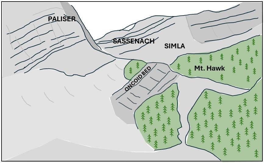
Supporting evidence for the idea of oncoid beds flagging major stratigraphic boundaries comes from the Jasper area of Alberta (37; Figure 6.2). The Devonian Frasnian-Fammenian extinction event, or Kellwaser event, is also marked by an oncoid bed (Whalen et al 2002). This bed is also used in the subsurface to alert drillers (and geologists) that they have reached the upper Mount Hawk Formation within the overall stratigraphy (pers. comm. Mark Mallamo 2023).
A previously unrecorded, anomalous bed of large oncoids (Figure 7.1), discovered in terrestrial clastic deposits during ongoing excavation at the Springbank Off-Stream Reservoir (SR1) Project, is associated with a highly significant iridium anomaly that strongly suggests that the oncoids grew and were deposited in response to the asteroid strike that triggered the K/Pg extinction event. It is postulated that many more intersections of this bed may have been encountered but passed over in core, and that oncoid beds may occur, in association with impactites, immediately overlying the depositional record of other extinction events triggered by asteroid impacts.
Alberta Transportation and Economic Corridors are thanked for their strong support of the monitoring program and for allowing publication of scientifically significant results. It should be noted that the SR1 Project location is a working construction site and completely off limits to the public. There are several other localities across the province where this stratigraphy can be examined in safety with permission (30). Any interesting finds should always be reported to the Royal Tyrrell Museum of Palaeontology.
1. https://www.alberta.ca/springbank-offstream-reservoir
2. https://www.alberta.ca/system/files/ custom_downloaded_images/tr-springbankreservoir-open-house.pdf
3. https://www.alberta.ca/living-by-thereservoir
4. Price, N. J. 1981. The Cordilleran foreland thrust and fold belt in the southern Canadian Rocky Mountains. In (eds.), Thrust and Nappe Tectonics, Geological Society of London, 427–448.
5. https://www.canadiantectonicsgroup. ca/uploads/1/0/9/2/109291477/ctg_ fieldtrip1992.pdf
6. McMechan, M. E. 1989. Geology of Peter Lougheed Provincial Park, Rocky Mountain Front Ranges, Alberta. Geological Survey of Canada, Open File Report 2017.
7. SA 1973, c 5 | The Alberta Heritage Act, 1973 | CanLII
8. Historical Resources Act, RSA 2000, c H-9.
9. Murphy, D. H. and Wilkinson, B. H. 1980. Carbonate deposition and facies distribution in a central Michigan Marl Lake. Sedimentology, 27, 123–135.
10. Treese, T., Owen, R. M., and Wilkinson, B. H. 1981. SrCa and MgCa ratios in polygenetic carbonate allochems from a Michigan marl lake. Geochemica et Cosmochimica Acta, 45, 439–445.
11. Weiss, M. P. 1969. Oncolites, paleoecology, and Laramide tectonics, central Utah. Bull. Am. Assoc. Pet. Geol., 53, 1105–1120.
12. Platt, N. H. 1989. Continental sedimentation in an evolving rift basin: The Lower Cretaceous of the western Cameros Basin (northern Spain). Sedimentary Geology, 64, 91–109.
13. Freeman, T., Rosell, J., and Obrador, A. 2006. Oncolites from lacustrine sediments in the Cretaceous of north-eastern Spain. Sedimentology, 29, 433–436.
14. Lindqvist, J. K. 1994. Lacustrine stromatolites and oncoids: Manuherikia Group (Miocene), New Zealand. In Bertrand-Sarfati and C. Monty (eds.), Phanerozoic Stromatolites II, 227–254.
15. Winsborough, B. M., Seeler, J.-S., Golubic, S., Folk, R. L., and Maguire, B. 1994. Recent fresh-water lacustrine stromatolites, stromatolitic mats and oncoids from northeastern Mexico. In BertrandSarfati and C. Monty (eds.), Phanerozoic Stromatolites II, 71–100.
16. Shapiro, R., Fricke, H. C., and Fox, K. 2009. Dinosaur-bearing oncoids from ephemeral lakes of the Lower Cretaceous Cedar Mountain Formation, Utah. PALAIOS, 24, 51–58.
17. Zamarreno, I, Anadon, P., and Utrilla, R. 1997. Sedimentology and isotopic composition of Upper Palaeocene to Eocene non-marine stromatolites, eastern Ebro Basin, NE Spain. Sedimentology, 44, 159–176.
18. Arenas-Abad, C., Vasquez-Urbez, M., PardoTirapu, G., and Sancho-Marcen, C. 2010. Fluvial and associated carbonate deposits. Developments in Sedimentology, 61, 133–175.
19. Arenas, C., Pinuela, L., and Garcia-Ramos, J. C. 2015. Climatic and tectonic controls on carbonate deposition in syn-rift siliciclastic fluvial systems: A case of microbialites and associated facies in the Late Jurassic. Sedimentology, 62, 1149–1183.
20. Verrechia, E. P., Freytet, P., Julien, J., and Baltzer, F. 1997. The unusual hydrodynamical behaviour of freshwater oncolites. Sedimentary Geology, 113, 225–243.
21. Vazquez-Urbez, M., Arenas, C., and Pardo, G. 2002. Facies fluvio-lacustres de la unidad superior de la Muela de Borja (Cuenca del Ebro): modelo sedimentario. Revista de la Sociedad Geologica de Espana, 15, 41254.
22. Mouline, P. 1977. La place des formations stromatolitiques et oncolitiques dans l’analyse sequentilelle des sediments fluviolacustres tertiaries du Castrais et de l’Albigeois. Bull. Soc. Hist. Nat. Toulouse, 113, 132–151.
23. Rott, E. 1994. The algal periphyton from River Alz (Bavaria). Ber. nat.-med. Verein Innsbruck, 81, 229–253.
24. Hägele, D., Leinfelder, R., Grau, J., ErnstGerhard Burmeister, E. G., and Struck, U. 2006. Oncoids from the river Alz (southern Germany): Tiny ecosystems in a phosphorus-limited environment. Palaeogeography, Palaeoclimatology, Palaeoecology, 237, 378–395.
25. Oguchi, T., Hori, K., and Oguchi, C. T. 2008. Paleohydrological implications of late Quaternary fluvial deposits in and around archaeological sites in Syria. Geomorphology, 101, 33–43.
26. Talanda, M., Bajdek, P., Niedzwiedzki, G., and Sulej, T. 2017. Upper Triassic freshwater oncoids from Silesia (southern Poland) and their microfossil biota. N. Jb. Geol. Palaont. Abh. 284, 43–56.
27. Jewula, K., Matysik, M., Paszkowski, M., and Szulc, J. 2019. The late Triassic development of playa, gilgai floodplain, and fluvial environments from Upper Silesia, southern Poland. Sedimentary Geology, 379, 25–45.
28. Talanda, M., Bajdek, P., Niedzwiedzki, G., and Sulej, T. 2017. Upper Triassic
freshwater oncoids from Silesia (southern Poland) and their microfossil biota. Neues Jahrbuch für Geologie und Paläontologie –Abhandlungen, 284, 43–56.
29. Astibia, H., Lopez-Martinez, N., Elorza, J., and Vicens, E. 2012. Increasing size and abundance of microbialites (oncoids) in connection with the K/T boundary in nonmarine environments in the South Central Pyrenees. Geologica Acta, 10, 209–226.
30. Jerrett, R., Price, G. D., Grimes, S. T. and Dawson, A. T. 2015. A paleoclimatic and paleoatmospheric record from peatlands accumulated during the CretaceousPaleogene boundary event, Western Interior Basin, Canada. GSA Bulletin, 127, 1564–1582.
31. Lerbekmo, J. F., Sweet, A. R., and Duke, M. J. M. 1996. A normal polarity subchron that embraces the K/T boundary: A measure of sedimentary continuity across the boundary and synchroneity of boundary events. Geological Society of America Special Paper 307, 455–476.
32. Armelin, M., Vasconcellos, M., Pereira, E., and Sircilli Neto, F. 1989. Determination of iridium concentration in sedimentary rocks and in the geochemical standard PCC-1 by radiochemical neutron activation analysis. Journal of Radioanalytical and Nuclear Chemistry, 132, 261–267.
33. Alvarez, L. W., Alvarez, W., Asaro, F., and Michel, H. V. 1980. Extraterrestrial cause for the Cretaceous-Tertiary extinction. Science, 208, 1085–1108.
34. DePalmaa, R. A., Smit, J., Burnham, D. A., Kuiper, K., Manning, P. L., Oleinik, A., Larsong, P., Maurrasse, F. J., Vellekoop, J., Richards, M. A., Gurcheb, L., and Alvarez, W. 2019. A seismically induced onshore surge deposit at the KPg boundary, North Dakota. PNAS, 116, 8190–8199.
35. Whalen, M. T., Day, J., Eberli, G. P., and Homewood, P. W. 2002. Microbial carbonates as indicators of environmental change and biotic crises in carbonate systems: examples from the Late Devonian, Alberta basin, Canada. Palaeogeography, Palaeoclimatology, Palaeoecology, 181, 127–151.
36. Alvarez, W. 1997. T. rex and the Crater of Doom. Princeton University Press.
37. Whalen, M. T., Day, J., Eberli, G. P. and Homewood, P. W. 2002. Microbial carbonates as indicators of environmental change and biotic crises in carbonate systems: examples from the Late Devonian, Alberta basin, Canada. Palaeogeography, Palaeoclimatology, Palaeoecology, 181, 127– 151.
1.
Trans Mountain Expansion officially online
2.
Oil growth to slow, while gas supply will accelerate
n Trans Mountain Expansion officially online
The long-delayed and way over-budget Trans Mountain pipeline expansion (TMX) finally started operations on 1 May 2024, with initial deliveries expected in the second half of May. Line fill began on 16 April. TMX will increase pipeline capacity to the Canadian West Coast from about 300 Kbd to 890 Kbd.
Proposal to start-up took 12 years, impacted by numerous lawsuits, protests, floods and changes of ownership and project management. When the Canadian government stepped in to rescue the project in 2018, the estimated cost to complete the project was Cdn$7 to 8 billion. Actual spending on the project was at least CdnS$36 billion (US$26 billion). The pipeline runs 1,150 km from Edmonton, Alberta to Burnaby, British Columbia.
TMX will increase Canadian producer access to both the US West Coast and Asian markets, and the incremental egress from the WCSB should reduce the chronic discount for western Canadian oil. Long-haul WCSB pipelines have been at or near maximum utilization. Thus, the impact will be felt across all oil sands producers, regardless of whether they ship on TMX.
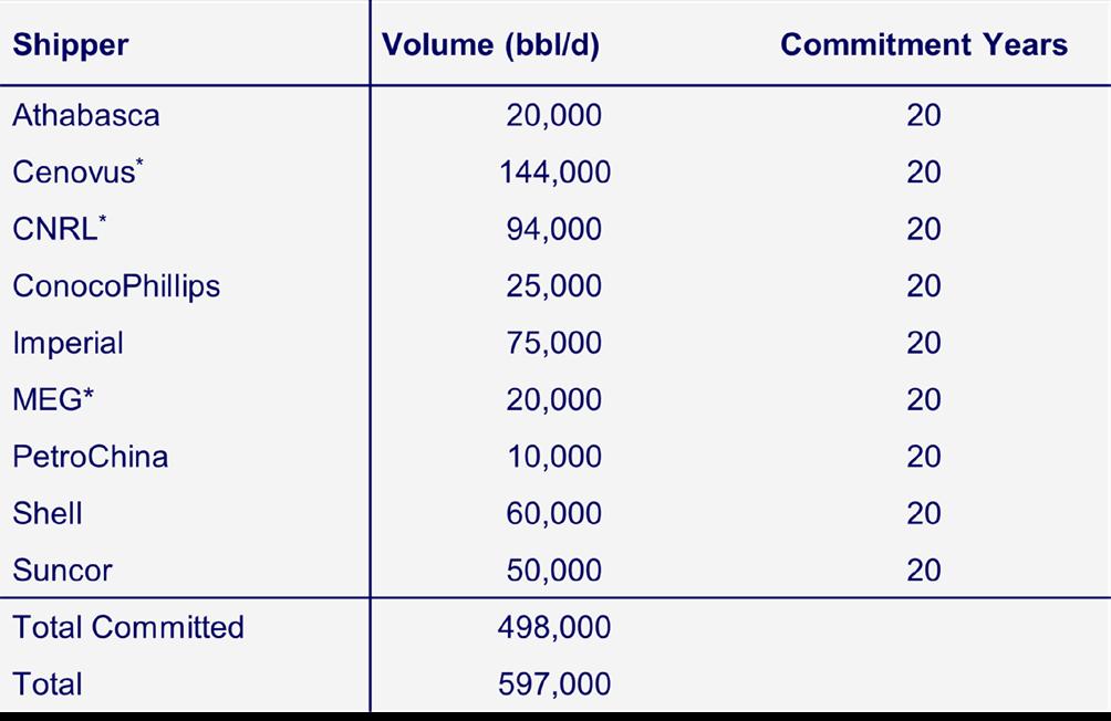
*Recent public disclosure. All other shippers are historical disclosures. Most of the region’s biggest producers have committed volumes to TMX and will be able to expand their presence in Pacific refining markets. Cenovus is the single largest shipper on the pipeline, with a 144 Kbd commitment. Woodmac’s commodity team estimates that about 80% of incremental Trans Mountain system volumes will be heavy crude in the first decade of expanded service.
3.
M&A continues with a focus on the Eagle Ford
n Oil growth to slow, but associated gas accelerates
US E&Ps surprised to the upside last year, with the sector growing by almost a million b/d. This took the US to new record levels of oil production. While no doubt impressive, don’t look for a repeat anytime soon.
This year marks a change in the trajectory of Lower 48 supply. Growth persists at a much lower rate and we forecast the Lower 48 will add a cumulative 1 million b/d by 2030. For comparison, the region added over 1.5 million b/d in the past two years alone.
Key drivers of the slowdown are continued consolidation and pared back pro forma plans, soft natural (associated) gas prices, and the benefits of D&C efficiency improvements being lower corporate capex instead of more volume growth.
Despite lower overall growth rates, significant new drilling will still be needed to offset base production declines and meet growing demand. We forecast that the Lower 48 will add nearly 3 million b/d of new oil production each year through 2030. Roughly 90% of that new supply, or roughly 2.7 million b/d, will go towards offsetting base declines each year.
Natural gas production growth through 2030 will also be modest relative to historic rates, with annual average growth of about 2.9 bcf/d vs. 4 bcf/d to 5 bcf/d in the past two years.
In the near-term, associated gas will make up the bulk of that growth given how challenging gas markets have been - and will continue to be - through next year.
The market dynamics will indeed shift though, especially starting in the second half of this decade. The call on long-term gas supply from nonassociated gas plays like the Haynesville and Marcellus is bright, with future market expansion due to resilient power demand and growing LNG exports.
n M&A continues with a focus on the Eagle Ford
Eagle Ford deal activity has been increasing in recent months. Some Eagle Ford transactions, like TotalEnergies acquisition of non-op Lewis Energy interests under EOG’s Dorado project, have been more gas focused given proximity to LNG facilities. But with ConocoPhillips, Private interest from the likes of Wildfire and small/mid cap activity such as Crescent Energy, the play is certainly being watched.
ConocoPhillips’ multi-basin Marathon buy
ConocoPhillips (COP) agreed to acquire Marathon Oil (MRO) on 29 May in a deal valued at US$22.5 billion, including US$5.4 billion of MRO’s net debt. The transaction is all stock with the price representing a 15% premium to MRO’s closing share price on 28 May. The deal is expected to close in Q4 2024 and puts this year back on trend to possibly match 2023’s record Permian M&A total.
Unlike COP’s previous Permian-focused acquisitions of Concho and Shell in 2020 and 2021, respectively, this deal was not solely about increasing Permian scale. Instead, COP is gaining valuable optionality and cash flow diversification by growing its existing Eagle Ford and Bakken positions materially (MRO’s Q1 2024 US production was 326,000 boe/d) while also adding new LNG exposure in Equatorial Guinea. COP will dominate the Eagle Ford going forward, which goes full circle from the company being one of the first movers in the play’s discovery.
Apache exits following Callon close
On 20 May 2024, Apache announced an agreement to sell 237,000 net acres in the Eagle Ford/Austin Chalk and 24,000 net royalty acres in the Midland Basin for US$700 million. The Eagle Ford assets were sold to WildFire Energy, increasing the buyer’s position to 850,000 net acres. WildFire messaged that this deal makes it the largest Eagle Ford acreageholder. The Midland royalty interests are non-op positions, and the buyer was not disclosed.
Daily production of Apache’s Southeast Texas assets was 11,000 boe/d (net) in the first quarter of 2024. Volumes span Fayette, Lee, Washington, Grimes, Burleson, and Brazos counties. It is the most eastward Eagle Ford extension and was initially established as a black oil play by Apache itself. The Midland Basin royalty acreage produced 2,000 boe/d net in the first quarter of 2024.
Following the closing of its US$4.5 billion acquisition of Callon, both investors and analysts expected the Permian would be the focus of Apache’s Lower 48 development. In its first quarter 2024 earnings call, Apache stated one of its core goals is to strengthen its balance sheet by reducing the debt load associated with its Callon acquisition. The Eagle Ford position was a non-core asset and would struggle to compete for capital in the portfolio. In fact, at DUG last week (trip notes here), Apache mentioned onstage that the Eagle Ford position would sit better with a different owner. We conservatively value these Eagle Ford assets at US$305 million.
The total US$700 million proceeds for both packages will help offset Callon’s debt, but not by much. When it was acquired, Callon carried net debt of US$1.9 billion, representing a 17% increase to Apache’s existing liabilities.
On 16 May 2024 Crescent Energy (CRGY) announced the acquisition of SilverBow Resources (SBOW) for US$2.1 billion. Crescent Energy will emerge as the second largest producer in the Eagle Ford with pro forma production of roughly 250,000 boe/d (39% oil, 17% NGL, 44% gas) over 440,000 net acres. EOG is the only larger producer. This deal is expected to close by the end of Q3 2024.
SBOW has been the fastest-growing E&P (17.9% production CAGR) in the Eagle Ford since 2020. Through an aggressive M&A consolidation strategy – eight deals since summer 2021 – SBOW patched together a diverse acreage footprint spanning seven counties across multiple phase
windows. Production diversity over short surface distances at SBOW’s scale is rare and has been a strength highlighted by the management team. Activity on gas acreage quickly accelerated in 2022, for example. SBOW’s total deal spend to help consolidate the play is just under US$1.4 billion. We found it hard to see how a continuation of SBOW’s established strategy would have put the company in a truly competitive position.
CRGY expects to realize between US$65 and US$100 million of annualized synergies due to cost of capital reductions, operational adjacency, and overhead savings. CRGY is currently running one rig in the Eagle Ford while SBOW is running three, with plans to drop to two for H2 2024.
This deal comes after SBOW navigated a failed proposal by Kimmeridge to merge with KTG. SBOW claimed the deal would be dilutive to its shareholders, disagreeing with the proposed valuation of KTG assets and exchange ratio. Throughout that lively process, Kimmeridge (12.9% shareholder of SBOW) mounted a proxy fight outlining changes to the board and proposing several other strategic transactions to build scale. SBOW’s board opted for a sale to CRGY instead.
CRGY isn’t a common Eagle Ford name, being relatively new to operated assets. The company held mostly non-op interests prior to May 2023 and its two breakthrough deals sum to US$850 million of acquisitions. Having mostly non-op experience could have contributed to negative market reaction. CRGY equity traded down 5% on the day of the announcement.
Post-close, CRGY gearing is expected to increase to 50% due to the additional debt to fund the cash portion (up to US$400 million) of the deal. This will put hyper focus on meeting synergy targets but it’s an uphill climb. Acreage positions aren’t that adjacent.

Scott joined the Canadian Upstream Research team at Wood Mackenzie in June 2019. He is responsible for providing financial asset valuation and objective commercial analysis on company and play activity across Canada. His coverage ranges from North American large caps to junior private producers. He also covers CNRL and Cenovus for the corporate analysis team, providing high level company valuation and strategy analysis.

Research Associate, Canadian Upstream Research
Xin's responsibilities include financial asset valuation and emissions modelling for Canadian and Alaskan assets. She also contributes to corporate analysis for Canadian and international mid caps and large caps such as Tourmaline Oil and Chevron.


July 20th
Saturday | 9 am to 4:30 pm MST
Go Take a Hike Together
Nihahi Ridge, Kananaskis Country, AB
Leaders: Mark Mallamo & Andre Chow
Location: Nihahi Trailhead, Kananaskis, AB
July 20th
Saturday | 1 pm – 3:30 pm MST
Go Take a Walk...Together!

August 14th
Wednesday | 1 pm – 7 pm MST
2024 CEGA Golf Tournament
Location: Lynx Ridge Golf Club 8 Lynx Ridge Blvd, Calgary, AB T3L 2M3
August 17th
Saturday | 8 am – 8 pm MST
Walcott Quarry Field Trip
Burgess Shale Foundation
Exploring and Studying 450-Million-Year-Old
Ordovician Fossils in Inner City Calgary
Leader: Tako Koning
Location: Kensington Safeway 410 10th Street NW Calgary, AB T2N 1V9
July 30th
Tuesday | 9 am – 4 pm
Student/ Recent Graduate Carbon
Storage Monitoring Field Trip with Carbon Management Canada
Facilitator: Carbon Management Canada
Location: Newell County Facility
Leader: Simon Haynes
Location: Yoho National Park Visitor Centre
September 26th
Thursday | 6 pm – 9 pm
Sweat the Subsurface Road Race and Fun Run
5km or 10km Option
Location: Sien Lok Park Riverfront Avenue & 1 Street Southwest, Calgary, AB T2P 0X2
AUGUST 14, 2024
Lynx Ridge Golf Club 1:00 pm - 7:00 pm
The CEGA Golf Tournament is a non-competitive, best ball format event where our members and other energy industry professionals can network while enjoying a day at the Lynx Ridge Golf Course. Join us for the 32nd annual CEGA Golf Tournament, where winning prizes is just a bonus!
We're seeking sponsors for our annual golf tournament! This is a fantastic opportunity to showcase your brand and connect with our community.
Click the button to register for this tournament, learn more about the tournament and sponsorship opportunities.


RIGSAT Communications
Ikon Science Ltd.
Torys LLP
Athabasca Oil Corporation
Belloy Petroleum Consulting
Eavor
National Oilwell Varco (NOV)
Hammerhead Resources
Key Seismic Solutions Ltd.


Petrocraft Products Ltd.
Tallman Geological
University of Calgary
RPS Group
Schlumberger Technology Corporation
Svante Inc.
Continental Laboratories (1985) Ltd. - Calgary, AB (2050)
Cossack Land Services Ltd.
DMT Geoscience
Earth Signal Processing Ltd.
Echo Seismic
LXL Consulting
Prairie Lithium Corporation
Project Canary
ROGII Inc.
Weatherford International
XRF Solutions Ltd
Sigma Explorations
ALT - Advanced Logic Technology
BJV Design Inc.
Cordax Evaluation Technologies
Dynacore Solutions Ltd.
Headwater Seismic


Spectrum
Whiskey Jack Resources
GeologicAI
Peer-Solutions
Skilvirkur Consulting
Synterra Technologies