

11 Geomechanics For Everyone, a Series on Geomechanics for all Disciplines 17 Why Geologists Should Look at Rocks 22 Go Take a Hike $10.00 JULY/AUGUST 2013 VOLUME 40, ISSUE 7 Canadian Publication Mail Contract – 40070050


> GEOSCIENCE SOFTWARE
> CRITICAL INFORMATION
> CONNECTED WORKFLOWS


CONNECTED AT EV ERY TOUCH P OI NT


The IHS suite of geoscience software—which includes IHS Petra®, Kingdom®, LOGarc™ and GeoSyn™—is designed to seamlessly connect to the industry’s leading source of critical Oil & Gas information, eliminating the need to move data manually from source to source and project to project. With this powerful new combination, users can streamline data transfer, enhance database performance and simplify project sharing. The result? Workflows that connect like never before.
Connected workflows mean that IHS customers spend less time looking for data and more time looking for the next big opportunity. It’s just one of the many ways that IHS helps to advance the decisions that advance the Oil & Gas industry.
Find out more at IHS.com/geoscience

Streamline data transfer and simplify project sharing with IHS geoscience software and critical O&G information.
CSPG OFFICE
#110, 333 – 5th Avenue SW
Calgary, Alberta, Canada T2P 3B6
Tel: 403-264-5610
Web: www.cspg.org
Office hours: Monday to Friday, 8:30am to 4:00pm
Executive Director: Lis Bjeld
Tel: 403-513-1235, Email: lis.bjeld@cspg.org
Event Coordinator: Kristy Casebeer
Tel: 403-513-1226, Email: kristy.casebeer@cspg.org
Geoscience Coordinator: Kelsey Green
Tel: 403-513-1225, Email: kelsey.green@cspg.org
Member Services:
Tel: 403-264-5610, Email: membership@cspg.org
Publications and Website: Emma MacPherson
Email: emma.macpherson@cspg.org, Tel: 403-513-1230
Co-Manager, GeoConvention 2014: Aileen Lozie
Tel: 403-513-1227, Email: aileen.lozie@cspg.org
Database Administrator and Accounting: Kasandra Amaro
Maternity leave until January 2014
Corporate Sponsorship: Lis Bjeld
Tel: 403-513-1235, Email: lis.bjeld@cspg.org
Controller: Eric Tang
Tel: 403-513-1232, Email: eric.tang@cspg.org
EDITORS/AUTHORS
Please submit RESERVOIR articles to the CSPG office. Submission deadline is the 23rd day of the month, two months prior to issue date. (e.g., January 23 for the March issue).
To publish an article, the CSPG requires digital copies of the document. Text should be in Microsoft Word format and illustrations should be in TIFF format at 300 dpi., at final size. For additional information on manuscript preparation, refer to the Guidelines for Authors published in the CSPG Bulletin or contact the editor.
Technical Editors
Hugh S. Mosher Colin Yeo (Assistant Tech. Editor) Nunaga Resources Ltd. Encana Corporation
M.: 403-809-9997 Tel: 403-645-7724 Email: hsmosher@telus.net Email: colin.yeo@encana.com
Coordinating Editor
Emma MacPherson, Publications Coordinator, CSPG Tel: 403-513-1230, emma.macpherson@cspg.org, ADVERTISING
Advertising inquiries should be directed to Emma MacPherson, Tel: 403-513-1230 email: emma.macpherson@cspg.org. The deadline to reserve advertising space is the 23rd day of the month, two months prior to issue date.
RESERVOIR ISSUE 7 • JULY/AUGUST 2013 3 JULY/AUGUST 2013 – VOLUME 40, ISSUE 7 ARTICLES Geomechanics For Everyone, a Series on Geomechanics for all Disciplines ................ 11 CSPG University Outreach – Interview a Geologist .......................................................... 14 Why Geologists Should Look at Rocks ................................................................................... 17 2012 CSPG Link Award Formal Citation 20 Go Take A Hike 22 Looking for Assistance with Go Take A Hike Book 26 2012 CSPG Tracks Award Formal Citation 29 DEPARTMENTS Executive Comment .................................................................................................................. 5 Technical Luncheons ................................................................................................................. 8 Division Talks .............................................................................................................................. 9 Rock Shop 7, 13, 14, 16
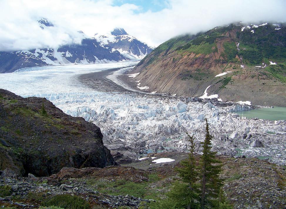
COVER The Salmon Glacier, lying on the Alaska / British Columbia border north of Stewart, B.C. is the fifth largest glacier in North America. This area has been subjected to several copper and gold mining ventures in the past. Photo by Bob Leonhardt.
FRONT
The RESERVOIR is published 11 times per year by the Canadian Society of Petroleum Geologists. This includes a combined issue for the months of July and August. The purpose of the RESERVOIR is to publicize the Society’s many activities and to promote the geosciences. We look for both technical and non-technical material to publish. Additional information on the RESERVOIR’s submission guidelines can be found at http://www.cspg. org/publications/pubs-reservoir-submissions.cfm. The contents of this publication may not be reproduced either in part or in full without the consent of the publisher. Additional copies of the RESERVOIR are available at the CSPG office. No official endorsement or sponsorship by the CSPG is implied for any advertisement, insert, or article that appears in the Reservoir unless otherwise noted. All submitted materials are reviewed by the editor. We reserve the right to edit all submissions, including letters to the Editor. Submissions must include your name, address, and membership number (if applicable). The material contained in this publication is intended for informational use only. While reasonable care has been taken, authors and the CSPG make no guarantees that any of the equations, schematics, or devices discussed will perform as expected or that they will give the desired results. Some information contained herein may be inaccurate or may vary from standard measurements. The CSPG expressly disclaims any and all liability for the acts, omissions, or conduct of any third-party user of information contained in this publication. Under no circumstances shall the CSPG and its officers, directors, employees, and agents be liable for any injury, loss, damage, or expense arising in any manner whatsoever from the acts, omissions, or conduct of any third-party user. Designed and Printed by The Data Group of Companies, Calgary, Alberta.
EXECUTIVE DIRECTOR –EARTH AND ENERGY RESOURCES LEADERSHIP PROFESSIONAL PROGRAM
Faculty of Arts and Science and Faculty of Engineering and Applied Science Queen’s University, Kingston, Ontario, Canada
One of Canada’s leading universities, Queen’s has a long-standing reputation for academic excellence, research, and a diverse and vibrant learning environment. With its strong tradition of public service, the University has helped to shape Canadian values and policies, educating notable political and cultural figures. Queen’s University is located in the heart of the community in historic Kingston, midpoint between Montreal, Toronto, and the nation’s capital.
Queen’s is seeking an outstanding individual to become the Executive Director of the new professional program in Earth and Energy Resources Leadership. Funded for the first three years by a generous alumni donation, this program will provide students with a comprehensive professional program, integrating courses taught by faculty and experts in the fields of Geological Sciences and Geological Engineering, Chemical Engineering, Policy, Law, Finance and Business.
The position will be based in Kingston, Ontario and the Executive Director will report to the Dean of the Faculty of Arts and Science and to the Dean of the Faculty of Engineering and Applied Science. During an initial three-year appointment, the Executive Director’s mandate will be to build and lead all aspects of an interdisciplinary and collaborative professional Master’s degree program in Earth and Energy Resources Leadership that has both national and international scope and impact. The program will be designed to meet the emerging needs of industry. The Executive Director will be responsible for the creation, development, growth, success and reputation of the program, in the context of the strategic plan and priorities of the University and the faculties.
We are seeking a well-known and respected industry expert from the resource sector. The ideal candidate will have:
A university degree in geological engineering or geology, chemical engineering, business, law, finance, public policy or other relevant field; a graduate degree is considered an asset.
Minimum 10 to 15 years of progressive experience in the Earth and Energy Resources sector, including several years at a senior executive level.
Demonstrated genuine interest and knowledge of and/or experience in a post-secondary educational environment.
Additional details can be found in the Position Profile posted at: www.geol.ca
Applicants should send their curriculum vitae, contact information, and the names of three references including their contact information to:
Robert P. Lemieux, Ph.D.
Associate Dean (Research), Faculty of Arts and Science F300, Mackintosh-Corry Hall Queen’s University
Kingston, Ontario, Canada K7L 3N6 email: rpl@queensu.ca
Review of applications will begin on July 15th, 2013. Applications will be accepted until the position is filled, preferably by September 1st, 2013.
The University invites applications from all qualified individuals. Queen’s is committed to employment equity and diversity in the workplace and welcomes applications from women, visible minorities, aboriginal people, persons with disabilities, and persons of any sexual orientation or gender identity.
All qualified candidates are encouraged to apply; however, Canadian citizens and permanent residents of Canada will be given priority.
www.queensu.ca


CSPG EXECUTIVE
President
Paul MacKay • Shale Petroleum Ltd. paul.mackay@shalepetroleum.com Tel: 403.457.3930
President elect
Dale Leckie • Nexen Inc. daleleckie@nexeninc.com Tel: 403.613.0458
Past President
Robin Mann • AJM Deloitte rcmann@deloitte.ca Tel: 403.648.3210
Finance director
Samantha Etherington • Barrick Energy SEtherington@barrick-energy.com Tel: 403.386.6459
Finance director elect
Gord Stabb • Durando Resources Corp. gstabb@durando.ca Tel: 403.819.8778
director
Dave Russum • AJM Deloitte drussum@deloitte.ca Tel: 403.648.3228
director Alexis Anastas • Nexen Inc. alexis_anastas@nexeninc.com Tel: 403.699.4965
director Mike Seifert • Canadian Discovery mseifert@canadiandiscovery.com Tel: 403.269.3644
director
Weishan Ren • Statoil Canada Ltd. wren@statoil.com Tel: 403.724.0325
director
Curtis Evans • ERCB curtis.evans@ercb.ca Tel: 403.297.8386
director
Dawn Hodgins • Imperial Oil Resources dawn.hodgins@exxonmobil.com Tel: 403.232.5931
director Andrew Fox • MEG Energy Corp. andrew.fox@megenergy.com Tel: 403.770.5345
e xecutive director
Lis Bjeld • CSPG lis.bjeld@cspg.org Tel: 403.513.1235
EXECUTIVE COMMENT
A message from Roger Hume, Chairman of the CSPG Educational Trust Fund
CSPG Educational Trust Fund (ETF) –the Challenge Ahead.
When I was asked by the incoming CSPG Executive to step up to the plate and take over as Chairman of the CSPG Educational Trust Fund, I knew that it would be both a great honour and a great challenge. The challenge that was set out by the CSPG Executive and stated in last year’s Executive Comment by interim ETF Chair, Steve Dryer, is to grow the size and significance of the ETF from its current size of $1.5 million to between five and ten million dollars. This was also re-iterated by Paul MacKay, this year’s CSPG President in his opening Executive Comment. The Trustees are evaluating the feasibility of achieving this aggressive target over a ten year period.
The growth of the fund to its present size has been due to the hard and dedicated work of those trustees who have been custodians and builders of the fund since its original founding. On behalf of all CSPG members, I would like to take this opportunity to acknowledge the tremendous efforts of those dedicated volunteers.
ETF – FAQ’S
What exactly is the ETF and what does it do for us?
Most important scientific and professional organizations establish educational trust funds to advance the knowledge and education of their specific disciplines as an important way of “giving back” to society and to giving a “lift up” to the next generation of scientists.
Our ETF is a registered charity, established by the CSPG, to advance the education of petroleum geosciences through its funding programs. This has historically targeted the education community at all levels, from the grade school to the post-graduate research level and from general knowledge of petroleum geoscience to advanced research. This is done through the funding of the various CSPG programs it supports. The specific focus on petroleum geoscience education is established and laid down in our
own deed document, which is controlled under government charity legislation and reviewed annually for compliance by the Canada Revenue Agency (our deed document can be reviewed on the CSPG website).
ETF supported following funding in 2012 fiscal year
Total $42,160
Who is responsible for managing the ETF and how?
The CSPG appoints a board of Trustees and Chair to act as custodians of the finances of the fund, to maintain and generate the fund’s future donations and to approve the programs and initiatives supported by the fund. At the time of writing, the board of Trustees consists of the following ten members; myself (Chairman), Steve Dryer, Andrew Fox, Simon Haynes, Dawn Hodgins, Stan Lavender, Robin Mann, Brett Norris, Kirk Osadetz, and Kyla Poelzer.
In order to make the work of the (Continued on page 7...)
RESERVOIR ISSUE 7 • JULY/AUGUST 2013 5
Glen Ruby Awards $10,000 Ballie Awards $2,000 CSPG Honorary Address $5,000 2012 geoConvention $5,000 Calgary Young Science Fair Society $660 CSPG Graduate Thesis $5,500 CSPG University Outreach Undergraduate Awards $2,000 CSPG University Outreach Lecture Tours $3,000 CSPG University Outreach Events Grants $5,000 CSPG High School Outreach $4,000

Canada’s Energy Geoscientists 25th Annual 10K/5K RoadRace & Fun Run Register now at www.cspg.org
CORPORATE SPONSORS
D Iamon D
GeoLOGIC Systems Ltd.
PlaTI num
APEGA
Cenovus Energy
ConocoPhilips Canada
Nexen
GolD
Devon Energy Corp.
IHS
Imperial Oil Ltd.
PLS
Shell Canada Limited
Statoil
S I lv E r
Arc Resources
Athabasca Oil Corporation
CNRL
CSEG Foundation
CSPG Educational Trust Fund
Encana Corporation
Enerplus
EOG Resources
LED Signs
MEG Energy Corp.
Roke Technologies Ltd.
TAQA North Ltd.
Bronz E
AGAT Laboratories
Apache Canada
Husky Energy Inc.
Loring Tarcore
Poggenpohl
RIGSAT Communications
RPS Energy
Schlumberger Canada Limited
Sensor Geophysical Ltd.
Suncor Energy
Talisman Energy
As of June 2013
A Special Thanks to Geologic Systems Ltd.,
C Sp G ’s Top S ponsor of the Month
Board of Trustees more efficient, four committees were established this April; an Awards Committee, a Finance and Audit Committee, a Development Committee and an Investment Committee.
Where does the money come from?
The funding for the ETF has generally come from three sources;
• Member donations.
• Industry donations.
• A transfer of a large portion of the annual profits from the CSPG, which is a non-profit organization but not itself a charity.
In the last financial year, ended August 31, 2012, the trust received the following amounts; $ 0 from the CSPG, $ 10,000 from industry and $27,598 from the membership. The Trustees are extremely grateful for all these financial contributions. There were and continue to be, significant individual donations from those members who make donations. However, given that we have 2,766 CSPG members today, most of whom are very well paid or of significant personal net worth, an average of $-10 donation per member is clearly not enough to provide any meaningful growth for the fund and its activities and achieve our long term objective.
Why is it important for us to support and fund the ETF?
There are literally thousands of excellent charitable causes for us to support in this country, and almost every CSPG member will allocate part of his or her time and money to helping others in our society through a wide spectrum of causes, from minor sports to the plight of the homeless. So why should the ETF find an important place in this crowded field?
ROCK SHOP
As geologists we understand and love our natural physical environment, but there are those, whose lack of knowledge of what we know and do, make judgments about us as geoscientists, about our industry and our vital leadership role in building the resource driven economy here in Canada. This economy supports one of the highest standards of living in the democratic world, an economy that was built on the knowledge and expertise of its geoscientists.
We have an obligation to do what we can to provide the next generation with a sound scientific basis on which to make choices and decisions in their lives. The CSPG can, along with the other applied scientific bodies, play a role in this through its support of the education process at the grade school level.
And if those young people choose to take on a career in the geosciences, we will also be there to encourage excellence in their undergraduate and post-graduate studies and research through the programs that the ETF supports and funds.
How do I donate to the ETF?
There are many ways to donate to the ETF; there is a line on your annual renewal to add a donation, or by writing a cheque directly to the ETF via the CSPG office at any time through the year or by adding a bequest in your will to the fund. And as a registered charity, a tax receipt will be issued by the fund for your donation.
The CSPG Educational Trust Fund thanks the CSPG membership for its support both in volunteer time and through monetary donations. Together we can make a difference to the lives of many.

RESERVOIR ISSUE 7 • JULY/AUGUST 2013 7
(...Continued from page 5)
www.rpsgroup.com/energy (403)263-0449 17084 Global Leaders in Wellsite Geology Serving the petroleum industry for over 25 years ■■ Conventional Vertical / Horizontal Wells ■■ Unconventional Heavy Oil / CBM Wells ■■ International WSG / Operations Geology
Webcasts sponsored by

The necessity of research: R&D projects that allowed for improved detection of reservoir in deepwater depositional systems
SPEAKER
Dr. a ndrea Fildani
t ime: t B d
l ocatio n: t B d
Each CSPG Technical Luncheon is 1 APEGA PDH credit. Tickets may be purchased online at www.cspg.org.
bIOGRA PH y
Andr ea Fildani was born and raised in Roma, Italy. He received his Laurea (M. Sc. equivalent) in Geological Sciences from the University of Roma “La Sapienza” and
his Ph.D. in Geological and Environmental Sciences from Stanford University. In 2004 he joined Chevron’s Quantitative Stratigraphy R&D Team in San Ramon, California, later called the Clastic Stratigraphy R&D team. In June 2013, Andrea moved to Austin, Texas, to join the new Statoil Research Centre.
Andrea’s research interests encompass different scales (from depositional bed to sedimentary basin; from exploration-scale to reservoir characterization) and span from fundamental principles such as stratigraphy,
sedimentology, and depositional processes to sequence stratigraphy and seismic stratigraphy, marine geology, and basin analysis. Andrea has worked several sedimentary basins around the globe (Gulf of Mexico, West Africa, Arctic Ocean, Indonesia, South America, Australia) and he has collaborated with Business Units to address all sorts of problems. Andrea has led field workshops in Patagonia, South Africa, the Spanish Pyrenees, and beautiful coastal California. He has authored and co-authored more than 30 manuscripts in peered-reviewed journals.
8 RESERVOIR ISSUE 7 • JULY/AUGUST 2013
tecHnical luncHeons SEPTEMBER LUNCHEON
division talKs PALAEONTOLOGY DIVISION
Climate Influence on Dinosaurian
Biostratigraphy in the Horseshoe Canyon Formation (Upper Cretaceous), Alberta, Canada
SPEAKER
David a . Eber th Royal Tyrrell Museum of Palaeontology
7:30 pm
Friday, September 20th, 2013 m ount r oyal u nive rsity, r oom B108 Calgary, a lbert a
The Upper Cretaceous Edmonton Group (Horseshoe Canyon Formation (HCFm), Battle and Scollard Formations) has yielded 209 partial-to-complete dinosaur skeletons and thousands of isolated elements. Considered in a stratigraphic and paleoenvironmental framework, these fossils reveal a high-resolution biostratigraphy that can help identify ecological and evolutionary responses among dinosaurs to a wide variety of environmental changes leading up to the K-T extinction event (e.g., climate, sea level, mountain building). Biostratigraphic analysis reveals a least three dinosaurian assemblage zones in the HCFm, each characterized by a unique assemblage of ornithischians.
These are:
1) Edmontosaurus regalis-Pachyrhinosaurus canadensis (lower zone);
2) Hypacrosaurus altispinus-Saurolophus osborni (middle zone); and
3) Eotri ceratops xerinsularis (upper zone).
Whereas the lowest two faunal zones (E. regalis-P. canadensis, H. altispinus-S. osborni) are based on numerous specimens of a least two taxa, the validity of the uppermost zone (E. xerinsularis) is tentative because it is based on a single specimen and the absence of dinosaur taxa. The transition from the E. regalis-P. canadensis zone to the H. altispinus-S. osborni zone was a response
to climatic change in southern Alberta that witnessed the replacement of a warm-andwet saturated deltaic setting with a cooler, coastal-plain landscape, characterized by more strongly seasonal rainfall and betterdrained substrates. Changes in mean annual temperature and proximity to shoreline had little influence on this change; it most likely reflected changes in rainfall and substrate response. We speculate that the transition from the H. altispinus-S osborni zone to the E. xerinsularis zone was also a response to paleoenvironmental change back to wetter-and-warmer climatic conditions, and the re-establishment of poorly-drained substrates. Thus, the two ‘faunal turnovers’ in the HCFm represent responses to paleoclimate and are not reflective of significant and widespread evolutionary events (rapid diversification events or extinctions at the genus level or higher) such as those that distinguish the Dinosaur Park, Horseshoe Canyon, and Scollard Formations ‘faunas’ and are the basis of the Judithian, Edmontonian, and Lancian LVAs. Dinosaur assemblage zones have also been identified in the dinosaur-rich Dinosaur Park Formation (DPFm, Upper Campanian, Alberta), but are different than those in the HCFm:
(1) there is no evidence for significant climatic changes during deposition of the DPFm;
(2) the HC Fm biozones are of much greater duration (1.6-1.9 Ma) with each one more-or-less encompassing the full duration of the DPFm (1.5Ma); and
(3) faun al turnovers in the HCFm appear to involve more distantly-related taxa.
This suggests a greater degree of anagenic evolution in DPFm ornithischians (possibly due to rapid socio-sexual selection) contrasted with longer-term morphological stasis in HCFm ornithischians and significant climate-change-driven dinosaur migrationevents into and out of the Drumheller area.
bIOGR
APH y
David A. Eberth (Ph.D. University of Toronto; M.A., University of California, Berkeley), Royal Tyrrell Museum, Drumheller, Alberta Senior Research Scientist, Sedimentary Geology & Paleoecology
Dr. David A. Eberth is a paleontologist and geologist at the Royal Tyrrell Museum in Alberta, Canada. He studies stratigraphy and ancient environments of fossil-bearing rocks,
Sponsored by
and has participated in field projects around the world. His specialties include the study of ancient physical environments, the age of the rocks, and how ancient plants and animals are preserved. He also has a deep interest in the causes for the revival of American creationism. Dave’s research sheds light on Earth’s ancient environments and how advances in the earth sciences impact society and culture.
Dave has written and presented more than 100 papers in a career that, so far, spans 33 years. He has organized and hosted symposia at the Royal Tyrrell Museum, and is the coeditor and a contributor for two recently published scientific books on bonebeds and horned dinosaurs. He is now co-editing a third book about duck-billed dinosaurs.
I NFOR MATION
This event is jointly presented by the Alberta Palaeontological Society, Mount Royal University Earth Science Department, the CSPG Palaeontology Division and Cenovus Energy. For details or to present a talk in the future please contact CSPG Paleo Division Chair Philip Benham at 403-691-3343 or APS Coordinator Harold Whittaker at 403-2860349 or contact programs@albertapaleo.org. Visit the APS website for confirmation of event times and upcoming speakers: http://www. albertapaleo.org/.
RESERVOIR ISSUE 7 • JULY/AUGUST 2013 9
division talKs STRUCTURAL DIVISION
Structural Geology Section Annual Trip
On September 22nd 2012, the Ptarmigan Cirque in Kananaskis was the site of the annual fall field trip organized by the Structural Geology Division. The weather was perfect and the grizzly bears had finally departed after four weeks of “camping” in the cirque. The party was composed of 24 professionals and students, and was led by Deborah Sanderson and myself. The Upper Mississippian succession is well exposed and interesting structural deformation features can be observed on the Southern and Eastern part of the cirque. It was sunny without clouds; it was good but not ideal for making perfect pictures of the nice folds and compressional features to the south. To obtain the best geology photos you need to stay until late afternoon when the sun has moved further west.
Mixed background for the participants of such trips has been again the norm with
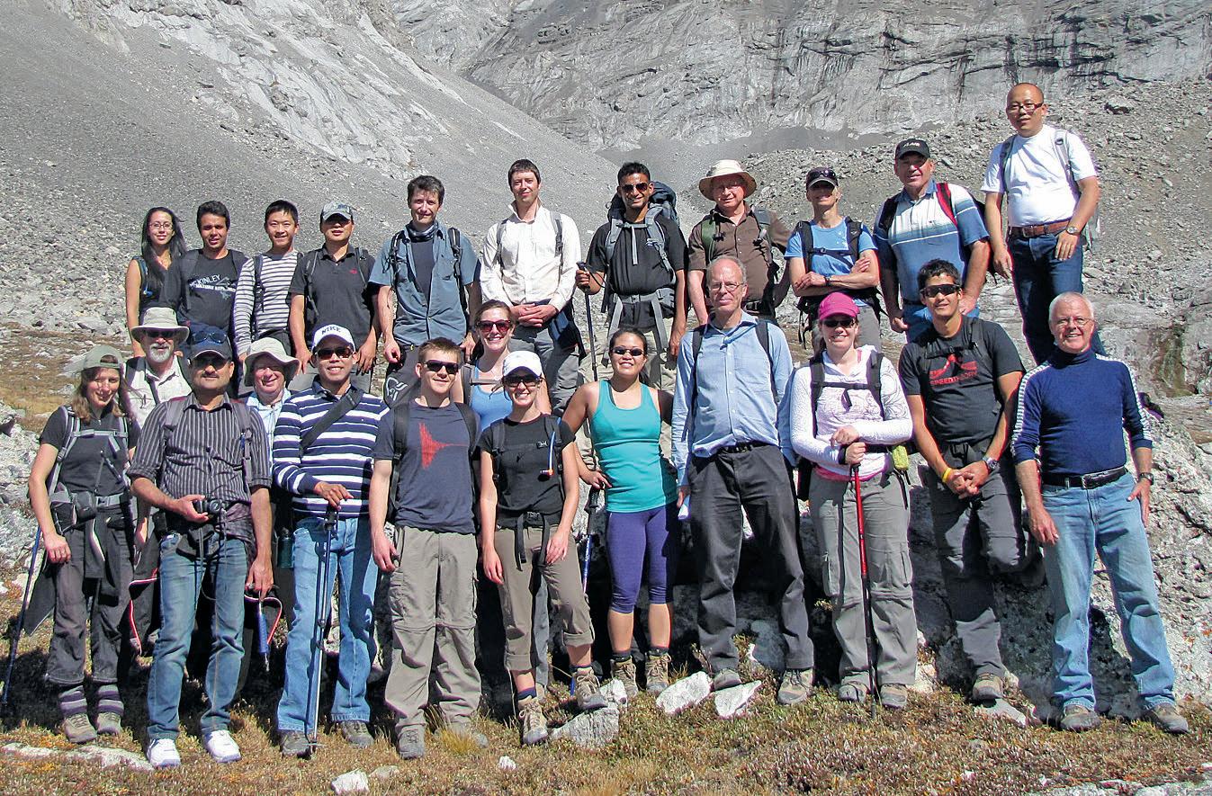
numerous graduating students from U of Alberta and U of Calgary networking with professional geologists, many of whom are structural geologists by background.
This coming Saturday September 21st, the annual field trip will visit the Barrier Lake
Thrust Stack, in Kananaskis country. The trip is free and open to all geoscientists and is on a first come basis. If interested, please e-mail me at jeanch@usa.net.
Jean-Yves Chatellier, trip organiser.
10 RESERVOIR ISSUE 7 • JULY/AUGUST 2013
Sponsored by Topics and speakers at this year’s conference include: JOIN US AT THIS YEAR’S GUSSOW CONFERENCE REGISTER NOW AT www.cspg.org Seismic Attributes and Microseismic Advances Multidisciplinary Studies Mudstone Sedimentology Geomechanics and Natural Fracture Characterization Petrophysics in Unconventional Reservoirs
GEOMECHANICS FOR E VERyONE , a Series on Geomechanics for all Disciplines
| By Amy D. Fox, PhD, Director of Geomechanics, Canadian Discovery Ltd.
I NTRODUCTION
Today seems like an excellent day to write the introduction to a series of articles on geomechanics for CSPG Reservoir magazine. This morning I had a tense but productive call with a client regarding log-derived horizontal stress. The client was not at all pleased to hear that my opinion was that they were surely calculating something, but it wasn’t a real reflection of stress magnitude. I told them they could call it anything they wanted – Factor X, for example – but please don’t call it stress. Eventually they came around… reluctantly…sort-of.
A couple of hours later I was sitting at a lunch talk; “Nonconventional Geomechanics for Unconventional Resources,” presented by SPE Distinguished Lecturer Hamed Soroush. Dr. Soroush was asked about log-derived stress and rock properties. Without real measurements to calibrate with, he said, they are “useless.” Huzzah! Vindication! I think I even blurted out “Thank you!” But then I started thinking. Really? Totally useless? I
hope that’s not actually true. I’m sure many of our readers do, too. The fact is, log data are often all we have to go on for a lot of applications, and they certainly aren’t useless. The key, I think, is being completely clear on what we are calculating and careful in how we are using it. And we have to ask ourselves, does the result make geological sense?
The problematic nature of log-based stress is just one of many issues that geomechanics people such as myself and my series co-authors would like to shout from the rooftops, and that’s what we’re going to do through this series. We were originally going to call it Geomechanics for Geologists. Then we thought, no, engineers could use it, too. And geophysicists. And management. And, well, everyone!
HOw IS IT GOI NG TO wORK ?
Star ting with the next issue of Reservoir, my distinguished geomechanics colleagues and I will be presenting a series of articles on issues in geomechanics that we think
everyone needs to hear about. Some will be old and basic (the articles, not the authors), and some will be topics that are so new that nobody is likely to fully understand them or their implications yet. All will be readable and, hopefully, informative.
Among some of the topics we will be addressing, in no particular order, are: Geomechanical risk
Geomechanics in conventional vs. unconventional reservoirs
Borehole image analysis
Wellbore stability
Hydraulic fracturing
Caprock integrity and reservoir containment
Induced and triggered seismicity
m inifra c analysis
Petrophysics
Geomechanics for reservoir simulation
Geologic and measurement uncertainty
(Continued on page 12...)
RESERVOIR ISSUE 7 • JULY/AUGUST 2013 11
Golf
Registration is now open for the 24th Annual Mixed Golf Tournament Friday, August 23, 2013 Lynx Ridge Golf Club Please visit www.cspg.org to register today
CSPG Mixed
Tournament
People involved in the series will include:
Bob Bachman , Taurus Reservoir Solutions
Patrick Collins , Petroleum Geomechanics
r obert Hawkes , Trican
Paul Heffernan , HEF Petrophysical l aura Hynes , Baker Hughes
Pat m c l ellan , McLellan Energy Advisors
Daniel m oos , Baker Hughes
vahid m ostafavi , Talisman Energy
Chris n eale , MicrosSeismic Inc.
Blair n eil , Weatherford
Paige Snelling , MicroSeismic Inc.
Kris v ickerman , HEF Petrophysical
Keri Yule , CalFrac
wHAT IS GEOMECHANICS
A N y HOw?
Despite the fact that geomechanics has been around in our industry for a few decades now and has been gaining in visibility that whole time, a lot of people are still unclear on what it is, exactly. Is it rock mechanics? Is it petrophysics? Does it have something to do with earthquakes or fracture mechanics? I’m sure what I’m about to say will only serve to confuse things further, but yes, it is all of the above and more. Geomechanics, which literally means “mechanics of the earth,” overlaps with many disciplines and has an incredibly broad range of applications from

studying plate boundaries to predicting what mud weight is needed to drill a single well. It can be used to understand the effects of depletion or injection, to examine the risk of induced seismicity, to optimize production from natural fractures, to predict the effects of thermal changes on both fluids and the reservoir, and the list goes on. But what it really boils down to, especially in our industry, is what I call my practical definition of geomechanics (and which would probably scandalize my PhD advisor): it’s any way in which stresses, fluid pressures and rock properties affect decision-making in all stages of the reservoir life cycle. And if you don’t think it should affect your decision-making, then this series is for you.
T HE CHALLENGES A HEAD
Not long ago I was having a catch-up coffee with my boss and explaining the good and bad points of some geomechanics software I was evaluating. I babbled on excitedly about how it could forward model wellbore failure in a fast, interactive way, and when I stopped for a sip of coffee my boss burst out laughing and said, “You are such a geek!” He’s right, of course, and I make no bones about it. My colleagues like to tease me that I’m preaching the geomechanics gospel. I take that as a compliment.
I’m not the only geomechanics person who’s a geek. It’s a common malady among my kind. A considerable challenge, therefore, that we geomechanics folks face is building awareness that our discipline is not just super cool science but is also important from a business perspective. Sure, we are all capable of giving a mind-numbing, highly technical lecture on geomechanics and explaining the difference between a Mohr-Coulomb and Tresca failure criterion, but maybe we need to stop geeking out and simply show the value in what we do: we reduce risk, uncertainty and cost, and we increase probability of success.
The relatively sudden need to understand unconventional plays has left us scrambling to figure out in a few years what we had the luxury of decades to learn in conventional plays. Understanding geomechanics is pivotal to efficient unconventional resource development, and there are still some very significant questions that have not yet been answered (the role of brittleness included… don’t get me started on that!). To us it sometimes can seem like industry is ignoring this. I don’t know if that’s really the case. I think that most everyone agrees by now that science is the path to optimizing drilling and completions costs and increasing IP/ production in unconventionals, but the onus is on us as a geomechanics community to
12 RESERVOIR ISSUE 7 • JULY/AUGUST 2013
Quality Multi-clientData (...Continued from page 11)
step up the pace to meet this new challenge and provide that science. Educating people on some of the geomechanics basics is a good start and another reason why this series should be helpful.
Another huge challenge we must address is convincing industry to include geomechanics from the very beginning of field development, not just after an operator has drilled a series of disappointing, costly wells. Imagine two scenarios. In the first we have an operator that drills a horizontal in a direction governed by lease boundaries or because that’s the direction everyone else has been drilling in that area. They react to drilling surprises as they occur (What’s that? Your pipe is stuck?) and collect the standard minimum data required. They then pay for as many frac stages as they can afford and cross their fingers hoping for a good outcome. Same for the next well: wash, rinse, repeat. In many cases they will eventually find that this approach isn’t really working, and they don’t understand why. Then we have a different operator. They start with
ROCK SHOP
a field development plan that’s based on a preliminary understanding of the reservoir stresses, pressures and rock properties from seismic and offset well data. They drill an efficient, low-risk well, proactively addressing any expected issues. They target their data collection efforts to reduce uncertainty in the most important reservoir parameters. They plan their completion to take advantage of the geological and geomechanical setting, improving completion design efficiencies. And when all is said and done they use their drilling, completion, well and production data to refine their reservoir understanding so the next well can be drilled and stimulated with increased efficiency and value. How can we get there? How can we make everyone that second operator?
IN CLOSING
As a colleague once said to me, one of the most valuable things geomechanics does is provide a vehicle for getting various parts of the asset team talking to each other. We’re no longer in a world where our well trajectories should dictated by leases
RockWell Consulting


and mineral rights, where the well plan is handed off to the drilling team which is left on its own to figure out how to drill it, and the completion team is left to come up with a completion design purely from an engineering standpoint. Well, I suppose sometimes we are, but we probably shouldn’t be. From a geomechanics perspective, it’s the geology that should dictate the planning. Well trajectory will have implications for borehole stability, production from natural fractures, hydraulic fracture geometry and breakdown pressures, etc. Do more frac stages equate to more production? In some cases yes, but not in all. Can you drill the exact same well as a nearby big producer and get a dry hole? Sure you can. It’s all controlled by the geology, and geomechanics provides the link between geology and operations. That’s what this series will be about. I hope you will enjoy it, and we welcome your feedback. In fact, if you have a geomechanics question or issue you’d like us to consider including in the series, please email me at afox@ canadiandiscovery.com.

RESERVOIR ISSUE 7 • JULY/AUGUST 2013 13
petrographical & sedimentological descriptions for samples (thin section - fluid inclusion studies) conventional vertical/horizontal wells operations geology SPECIALIZED IN GEOLOGICAL WELLSITE SUPERVISION AND CORE ANALYSIS
our best friend and most valuable partner is our client Stephan C. Dragomir president www .g e ok2. c om - phon e: 403.831.9941 - s dr a gomir @ge ok2. com Strip Log Strip Log Horizontal Log Horizontal Log Mud Log Mud Log Log Viewer Log Viewer Log Manager Log Manager Log Analysis Log Analysis Suite 102, 7370 Sierra Morena Blvd SW, Calgary, AB T3H 4H9 info@WellSight.com 1-800-447-1534 (403) 237-9189
CSPG U NIVERSIT y OUTREACH –Interview a Geologist
| By Melanie Klucker and Mark Rabin
We’ve decided to try something new here at the University Outreach Committee, and diverge somewhat from our normal format. We were curious as to what advice and experiences prominent geologists had to give to young up and coming geologists. For our first installment, we managed to catch the very busy Dr. Dale Leckie and asked him to talk to about his experiences working as a geologist in the oil and gas industry over the past 30 years. Thanks for reading and enjoy!
• name: Dr. Dale Leckie, P. Geol.
• Title and Company: Chief Geologist, Nexen Inc.
• Primary role: My role is mainly technical with some geoscience process involvement. I monitor and work to bring new geological technology to Nexen. I support Universities and University research consortia to bring leading edge geo-technology into the company. I work closely with Nexen’s technical excellence and technical assurance groups. I also mentor as a technical specialist for various groups.
• most Significant Career achievements / milestones: I have received numerous awards from several societies for the contributions that I have made. I have been an AAPG Distinguished Lecturer twice, a CSPG Distinguished Lecturer, have received the CSPG Medal of Merit three times, am an SEPM Honorary Member and so forth. These awards have been in recognition
ROCK SHOP

for my technical contributions, papers or presentations. To be recognized as such means that I have hit the mark and made a recognized contribution to others.
• associations / affiliations: CSPG, SEPM, AAPG, APEGA, GAC
• Education: PhD – McMaster University, 1984; MSc – McMaster University, 1980; B.Sc. – University of Alberta, 1978.
• Community Involvement: I get involved in the community in several ways. For the last five years I have been riding in the Enbridge Ride to Conquer Cancer. Family, friends, colleagues and the company that I work for have donated considerably to this great cause. I have also supported various technical societies throughout my career, traditionally by providing technical support – that is, writing scientific papers, giving oral presentations, leading

PAYZONE INC Consultants
Established 1980
Wellsite Geological Supervision Research and Sample Studies
Stephen C. Walton, President
403 861-0759
Email: payzone@telusplanet.net
field trips and such. I have organized conferences and research symposium for the societies. I have been on the executive of, and was President of SEPM. I am currently President-Elect of CSPG. For both CSPG and SEPM, I wanted to pay back to those societies for all that I had benefited from them. I appreciate the support that Nexen has provided to carry out these activities.
Q&A
What was your first job in industry, and what were your first impressions? How are things different now?
I started my career with Petro-Canada in the Research Lab by the University and then went downtown to work in an exploration group. After 3 years, I had an opportunity to go the Geological Survey of Canada, where I stayed for 13 years as a Research Scientist working on gas and oil fields in Western Canada. In 1998, it was time for change and I went to a predecessor company of Nexen as Chief Geologist. What I see as most different today is the social contract that our industry operates with. Thirty years ago, environmental and social responsibility played a minor role in what we did. Today, it is so important and second nature to most of us. As you well know, technology has also changed significantly and now plays such an important role in our jobs. Technology change has driven the most recent “boom” associated with the unconventional resources of shale gas, tight oil and the oil sands. Because of that technology change, we are now seeing much more integrated teams in the energy sector.
What has helped you to achieve success in your career?
I have always tried to be as technically proficient as possible – taking courses, teaching myself and attending conferences. I often learned by writing scientific papers or preparing for oral presentations. I always have, and still, devour scientific journals of all types – I am an avid reader. Communication is also so very important for my success. To be able to listen to people about what works for them and for them to hear what I have to say has been a key to my success.
14 RESERVOIR ISSUE 7 • JULY/AUGUST 2013
What do you find compelling or engaging about working in the energy industry? Why should young geoscientists pursue a career in this sector?
Calgary is such an exciting and vibrant community because of the oil industry with a very strong geological community. It is the heart of the Canadian energy industry and drives the Canadian economy. The energy industry provides employment for people across the nation and is very responsible for the current balance of trade in the country. I am proud to be part of that. I think that young geoscientists should feel the same in their careers.
The energy industry brings many benefits to Canadian society, both economic and social. It is essential to maintaining our standard of living and promoting development globally. Yet, it seems that the energy sector does not get the credit it deserves and that public opinion is fraught with misconceptions. What, in your view, can we as geoscientists and energy professionals do to improve this situation?
A considerable amount of misinformation exists. The Canadian energy sector provides the high standard of living that many Canadians benefit from. It is critical that we, as geoscientists, get out and talk to individuals and groups who are looking for truthful information. This can be friends, family, teachers or young school
children who are often looking for balanced perspectives from which they can make up their own my minds. I did this last year, when I put together a presentation entitled “The Science of Fracking – Society Issues and Perceptions,” which I presented to technical and non-technical groups, universities and government bodies essentially around the world. This year, I was the moderator at the “Fracking Truth” hosted by the Schulich School of Engineering Alumni Chapter. We have to become informed, stay informed and communicate – even at a grass roots level.
What do you think are some of the greatest challenges currently facing industry? What changes or innovations do you foresee arising to help companies overcome these challenges?
The greatest challenge right now is public perception and a pervasive anti-gas and oil industry sentiment, which I believe is unwarranted. We have to communicate to all levels of society what the major contributions to society that the energy sector is making. We must speak factually and place many of the negative aspects in a true perspective.
What role have mentors played in your career? How were you able to gain the most that you could from mentors and peers throughout your career?
Mentors have been an important part of my career – even now. There are several individuals who have provided guidance and insight for my career. The ones that I appreciated the most were those whom left me fully enthused and excited about what they and I were doing. They were ones who motived me and still do!
What do you wish you would have known before starting your career and what advice do you have for upand-coming geoscientists just getting started in the energy industry?
On this one, I feel that I came prepared for the industry. Throughout my career in, and associated with, the energy industry, I have always been instructing and mentoring others. I was teaching AAPG short courses and leading field trips before I graduated. Since then though, there has been continuous improvement through the instructional vehicles I commented upon earlier. My advice is to learn as much as you can as early as you can and to try to apply those learnings.
How many days at year do you spend in the field?
I would be happy with up to 20 days!
RESERVOIR ISSUE 7 • JULY/AUGUST 2013 15
ROCK SHOP


16 RESERVOIR ISSUE 7 • JULY/AUGUST 2013
*Domestic & International Supervision 906, 505 6 St. SW Calgary, AB T2P-1X5 Jocelyn Lampron, P. Geol. President & CEO Wellsite Geological Supervision *Conventional Wells-Heavy Oil/SAGD *Coal Bed Methane Wells www.hopewellpetroleum.com info@hopewellpetroleum.com section ph: 403.266.3132 cell: 403.818.8549 *On & Offshore Geological Supervision Opus Training Group 403 720-9810 www.opustraininggroup.com Geology Training for the Petroleum Industry Wellsite 101 (The name that says it all!!!) Bus 403.234.7625 800, 555 - 4 th Avenue SW, Calgary, AB, T2P 3E7 info@WellsiteGeologists.com www.WellsiteGeologists.com 742 Memorial Drive NW Calgary,Alberta T2N 3C7 P: 403 242 1522 F: 403 242 8223 E: office@chinookconsulting.ca www.chinookconsulting.ca SERVICES • Wellsite geological supervision • Core and cuttings petrographic studies • Operations geology • Remote geo-steering and remote geological supervision • Project management • Domestic and International wellsite supervision • Conventional and Unconventional wells • Extensive Hz experience • Customized corporate solutions available (403) 250-3982 sales@clconsultants.ca www.clconsultants.ca 1602 – 5th St N.E. Calgary, AB T2E 7W3 Phone: 403-233-7729 www.tihconsulting.com e-mail: tih@shaw.ca T.I.H. Consulting Ltd. Geologic Well-Site Supervision PRACTICAL LOG ANALYSIS COURSES For Engineers, Geologists, Geophysicists, and Technicians Practical Quantitative Log Analysis: 15 – 17 Oct 2013 Analysis of Unconventional Reservoirs: 18 Oct 2013 Details and Registration at: www.spec2000.net/00-coursedates.htm In-House and Multi-Media Narrated Self-Study Courses Also Available === Instructor: E. R. (Ross) Crain. P.Eng. 1-403-845-2527 ross@spec2000.net === – 50 Years Worldwide Experience – Analysis, Training, Mentoring, Forensic Reviews –
wH y GEOLOGISTS SHOULD LOOK AT ROCKS
| By Jon Noad, Husky Energy
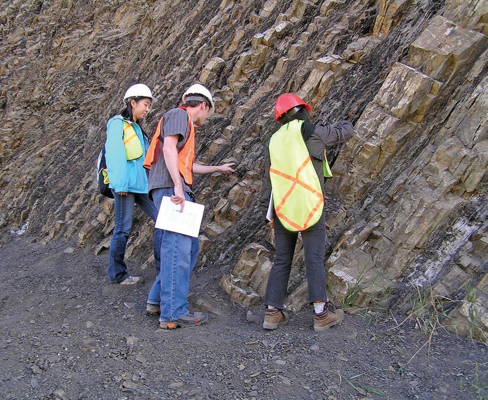
It is a question that sooner or later, every oil company boss will ask... “why should my geologists go on field geology courses?” It is actually a good question, as it makes us look at rock outcrops in a fresh light, and has a surprisingly wide variety of answers. To begin with, it is not only geologists that benefit from seeing rocks in two and three dimensions. Other technical disciplines can also learn about many aspects of geology, and share their viewpoint with the group on the outcrop. There is nothing like having “Nature’s Laboratory” in front of you to promote discussion and interaction between geologists and other technical disciplines.
Several basic concepts leap out at the geologist when confronted by any outcrop. Scale is a key ingredient, relating to bed thickness, as well as the size and distribution of sedimentary and structural features. The heterogeneity of most outcrops usually surprises many, both in terms of the lateral variation in bed thickness, changes in facies types and the often complex vertical interbedding of sandstones and shales, or wackestones, packstones and grainstones. This will have a huge impact on those working on upscaling reservoir models, and on seismic interpretation. However amid all this heterogeneity there
is usually some underlying cyclicity which careful observations can tease from the rocks. By looking at the rocks the whole team can gain an appreciation of the level of risk and uncertainty involved when interpreting three dimensional depositional architecture using only core or well logs.
Sedimentary rocks generate and host hydrocarbons, and are deposited in a huge range of sedimentary environments. Understanding the depositional settings can help to predict where oil and gas may be found, and hence the best place to drill. The outcrops of Alberta and beyond provide many excellent analogues that provide information on the style of sedimentary structures, the vertical and lateral extent of a particular facies, the porosity and permeability of different rock types, and how such rocks behave when deformed and fractured. They may also contain fossils and trace fossils that normally we would only get to observe in the thin “rock tubes” of core.
Almost every formation producing hydrocarbons from the subsurface can also be seen at surface, with most depositional settings that one could imagine accessible in western Alberta. Fluvial reservoirs such as the Paskapoo Formation outcrop around Calgary, while the Dinosaur Park and Oldman Formations are exposed in three dimensional exposures throughout Dinosaur Provincial Park and beyond. These rocks produce gas from ancient meandering and braided river systems in the shallow subsurface. Alluvial fan deposits of the Cadomin Formation, usually very resistant to erosion, outcrop around
(Continued on page 18 ...)
RESERVOIR ISSUE 7 • JULY/AUGUST 2013 17
SulphurGates. Steeply dipping outcrops of the Cadomin Formation close to Grande Cache, featuring clinoforms within the conglomerates.
SandyPoint. Exposures of the Cretaceous, dinosauriferous Oldman and Dinosaur Park Formations at Sandy Point, eastern Alberta.
Mount Allen and in many other locations, where vertically dipping conglomerates form the Rock Garden. These rocks are significant tight gas reservoirs.
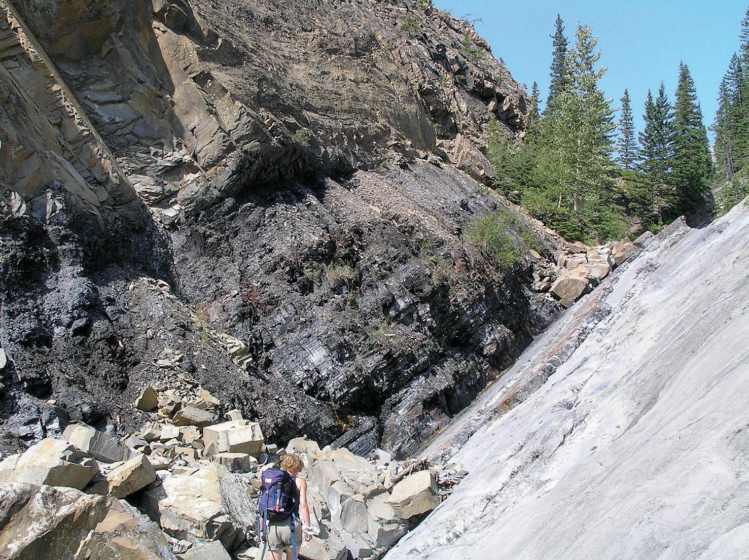
Shoreface deposits such as the Cadotte can be examined around Boulder Creek, and in the Cardium Formation outcropping just to the West of Calgary, while open marine siltstones outcrop on Mount Norquay, providing loose analogues to the Montney gas reservoirs. Fluvial to lower shoreface deposits of the Nikanassin Formation are also well exposed around Grande Cache, and produce gas in the subsurface across eastern BC. Deeper marine shales of the Exshaw Formation, a potential analogue to the Bakken siltstone, can be seen in Jura Creek, at Goat Creek close to Kananaskis and at Crowsnest Lake. Deep marine turbidites are exposed around Invermere, amongst many other localities such as the famous Banff Traffic Circle.
A whole suite of carbonate rocks are well exposed across the Rockies, with great Devonian and Mississippian outcrops along Highway 1A, in Jura Creek, at Moose Mountain and at Grassi Lakes and elsewhere. These limestones produce hydrocarbons across Alberta and beyond, such as in the subsurface of the Turner Valley and at Leduc. Where exposed a range of depositional facies can be identified and compared to core, cuttings and well log
data from producing reservoirs. In addition to the reservoir rocks described above, the other play elements necessary for a working petroleum system are also present in terms of trap, source rocks and seals. The Exshaw (mentioned above) is a good example of both a source rock and a seal, and other similar mudrocks can also be
examined around the province and beyond.
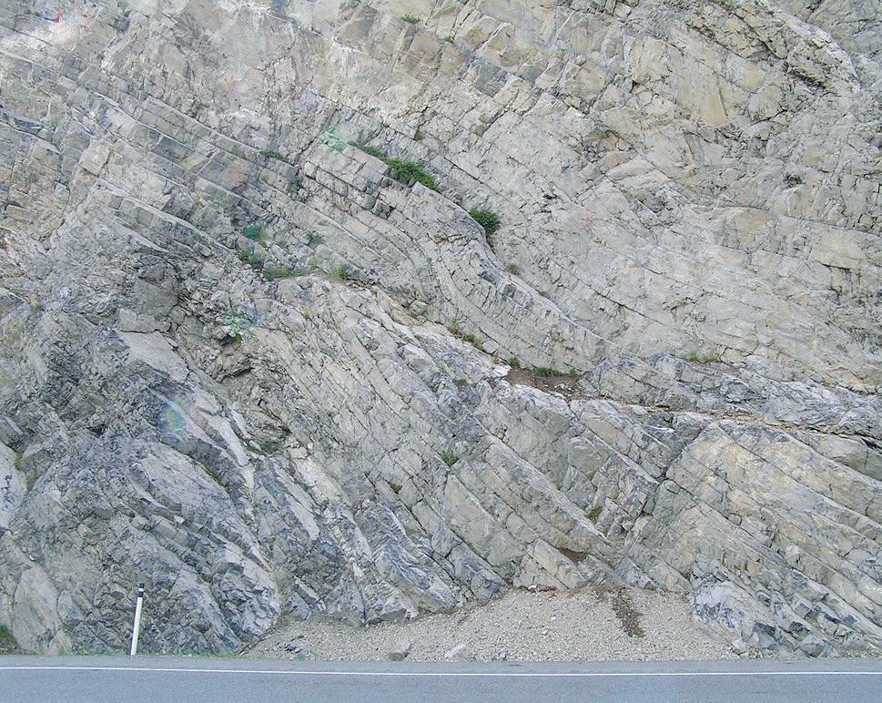
In terms of traps, the Rockies provides a natural laboratory to look at a classic compressional, folded and thrusted, structural regime. A range of thrusts can be viewed from afar, with classic overlook localities scattered through the Rockies, while getting your nose on the rocks will help to understand the development of associated fractures. Such structures are also influenced by the facies in which they propagate, something that becomes much more obvious when comparing the impact of folding on coals, shales, sandstones and limestones in outcrop. These rocks all behave in very different ways when subjected to stresses, depending on their heterogeneity, composition and grain size variation. A good idea of their preservation and potential for compaction can also be gained from fieldwork.
To summarise, getting back to the rocks in outcrop will lead to a better understanding of sedimentary structures, facies and their architecture. It allows us to assess the mineralogy of sandstones, the petrography of limestones, and the mineral constituents and geochemical properties of source rocks such as TOC, quartz and clay content and hence their fraccability. The nearby Rockies provide a window into compressional structural tectonics at all scales from the regional, through major thrusts and dramatic folding, and down to individual
18 RESERVOIR ISSUE 7 • JULY/AUGUST 2013
(...Continued from page 17)
Highway 1a. Outcrop of thinly bedded, heterolithic limestone facies exposed beneath the Mazama Ash on Highway 1A near Exshaw.
Traffic Circle. Non geologists experiencing their first turbidites in the Traffic Circle outcrop of the Fernie Formation at Banff.
fractures and networks. And there are not many places in the world where a huge variety of producing reservoirs outcrop at surface, ready to provide the perfect analogue to their subsurface counterparts.
Hence my advice is to sign up for a few field geology courses in our region. Take a multi disciplinary team into the field and all the participants can learn from one another. The geologists can set the scene. Petrophysicists can explain what well logs would show, geophysicists assess the seismic response at the outcrop scale, and reservoir engineers will decipher possible production performance, flow paths and simulation. It is much easier to explain geological concepts in outcrop than through reading the dusty pages of a geology book. Every rock may provide just the analogue you need when back in the office. Simply remember that the more rocks you get to see, the better geologist you will undoubtedly become.
RESERVOIR ISSUE 7 • JULY/AUGUST 2013 19
Jura Creek. The much missed Cindy Reidiger climbing towards a magnificent exposure of the Exshaw Formation in Jura Creek.
Crownest lake. Outcrop scale thrust and duplex structures in the Mississippian Banff Formation at Crowsnest Lake.
2012 CSPG L INK AwARD Formal Citation
The CSPG Link Award committee has been evaluating presentations at the Technical Luncheons of the Society since 1958. The mandate of the committee is to evaluate all member talks and to select the best oral presentation to the membership. The emphasis has always been on the quality of the presentation as it relates to speaking excellent and judicious use of illustrations. Scientific interest is an important but secondary consideration as this is more
the domain of scientific journals and peer reviews. The list of Link Award winners serve as a history of Canadian petroleum geology and the accomplished geologists who work to advance and communicate new concepts. Eligible speakers must be members of the Society and must not be a previous recipient of the Link Award.
John R. Suter has worked in Oil Sands, ConocoPhillips Canada, since 2009 as an Advisor, Technical Studies Coordinator, and Regional Subsurface Manager, where he has been primarily responsible for the regional assessment and interpretation of oil sands deposits within the Athabasca Basin, as well as coordinating and conducting technical studies on individual properties. His primary expertise is in clastic facies and sequence stratigraphy. John received undergraduate and Master’s degrees in geology at the University of Texas-Austin, and the Ph.D. in geology from Louisiana State University.
He started as a marine geologist with the USGS, LGS, and LSU in the early 1980’s, and the early phase of his
career focused on modern depositional environments and Quaternary sequence stratigraphy, particularly of the Mississippi Delta and adjacent areas of the northwest Gulf of Mexico. John moved to Exxon Production Research in 1988, joined Conoco in 1994, and was absorbed by ConocoPhillips in 2002. Prior to Oil Sands, John spent his industry career in technology groups, doing research, technical service work, and training. He worked projects involving source, seal, and reservoir for conventional and non-conventional deposits at exploration, appraisal, development, and production scales on multiple continents. In addition to Oil Sands, he has most recently worked in the North Sea, eastern Greenland, Canadian Arctic, Lower 48 USA, and Venezuela. He has published numerous papers, organized multiple research conferences, and has taught a variety of short courses, field schools, and core workshops; both internally, for national oil companies, scientific societies, and universities.

Joh n has received awards for papers, presentations, and posters from various professional societies, including AAPG, AASP, CSPG, GCAGS, SEG, and SEPM. He was an AAPG Distinguished Lecturer, served as SEPM Councillor for Research, and is currently the co-chairman of the AAPG Technical Advisory Committee. The presentation which received the 2012 CSPG Link Award “Geological Characterization of the Surmont Caprock Interval,” provided an overview of the geological aspect of an evaluation of the caprock integrity at ConocoPhillips’ Surmont SAGD development. The project was an integrated, multi-disciplinary effort involving numerous collaborators from across ConocoPhillips, academia, and industry vendors. John gratefully acknowledges their contributions, the permission of ConocoPhillips and TOTAL to present the talk, and CSPG and the Link Award Committee for this honor.
20 RESERVOIR ISSUE 7 • JULY/AUGUST 2013
geo-reservoirsolutions.com Geo-Reservoir Solutions offers a broad base of seismic interpretation experience as well as a full array of software tools to provide full reservoir characterization and Quantitative Interpretation (Q.I.) of reservoir properties. RokDoc software is utilized to provide highly calibrated results to characterize sub-surface reservoirs. Quantitative i nterpretation services Contact us for more detailed information and find out how we can help you make the best decision. calibrations analysis integration rock physics expertise in Integrated Subsurface Solutions 403.703.8748 interp@geo-reservoirsolutions.com Featuring Interpretation Consulting - offering experience in all technical operations ... RECORDER_GEORes_QuantInt_02_2013.indd 1 2013-02-22 8:27 AM
John Suter
The Right Source. The Right Course.
AAPG’s 8th Annual Fall Education Conference in Houston offers five enlightening days of geoscience courses led by today’s most renowned experts—at one outstanding price. With three concurrent sessions each day, you choose the topics that interest you.
What’s more, if you become an AAPG member, you’ll save $300 off the regular non-member price through Sept. 16. With buffet lunches and beverages included every day, there’s never been a better opportunity to expand your knowledge and reveal your inner explorer.
The right source for the right education, right now. That’s AAPG. Register today.
Geoscience in the Horizontal Domain - Applications to Current and Unconventional Resources
u Horizontal Well Stimulations in Tight & Unconventional Formations
u Geological and Petrophysical Approaches to Geosteering
u Applications for Chemostratigraphy in Horizontal Wells
u Geopressure Predictions and Exploration Risk
u Logging High Angle / Horizontal Wells
u Evaluating Well Performance and Determining “Best Practices” for Conventional and Unconventional Reservoir Fracture Treatments
u Log Analysis of Shaly Sand Reservoirs
u Log Analysis of Hydrocarbon-bearing
u Tools and Techniques for Unconventional Assessment and Decision Making
AAPG | Fall Education Conference 2013
October 14-18 • Houston, Texas
Fall Education Conference 2013
October 14-18, 2013 • Houston, Texas
Hosted by: The Norris Conference Center 816 Town & Country Lane Houston, Texas 74024
V: 713.590.0950
F: 713.590.0961
(Special AAPG Group Rates at Nearby Hotels)
Registration and Information
Call AAPG toll free in the U.S. and Canada at 888.338.3387 or 918.560.2650
F: 918.560.2678
E: educate@aapg.org
W: www.aapg.org
Tuition for Price through Price after the week Sept.16 Sept. 16
AAPG Members $1795 $1995
Non Members $2095 $2295
Individual Courses $500/day $550/day


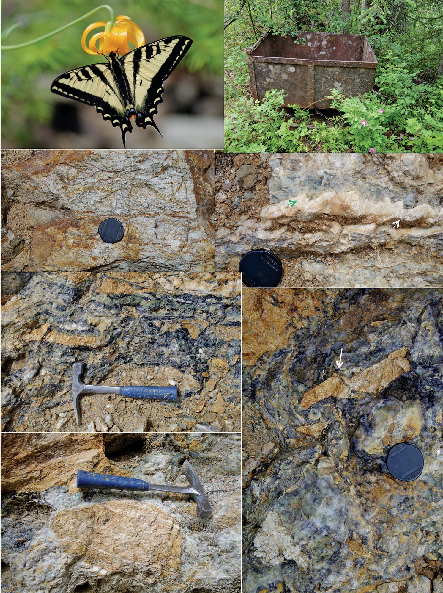
GO TAKE A HIKE
Rock Candy Mine, Granby, BC
| By Philip Benham and Ryan Benham
Tour: Scheduled group or private tours to the mine can be booked through http://www. rockcandymine.com/ or Grand Forks Visitor Centre: (250) 442 5835. The tours meet at Grand Forks Visitor Centre, in SE BC. After a guided drive to the mine site down gravel roads (4WD suggested) there will be a short hike to the mine. You are permitted to collect in designated areas. The site is under the watch of a care taker and can only be visited with prior appointment. For this reason no map is provided.
Distance: Hike is approximately 1km and requires about 40m elevation gain up switchback trails at the end to the mine site
Rock Candy Mine has its origins in a chance discovery over a hundred years ago. In 1911 a rancher on an outing found mineral outcrops in Kennedy Creek not far from town of Granby. The Cominco Copper Smelter located in nearby Trail needed fluorite (CaF2) for flux and by 1916 the first production at the mine was occurring. The role of a flux is that it lowers melting points and allows for the waste products in the smelter (including iron and silica) to fuse into slag. To service the new mine a 100 person town was established and bridge was built across the valley to access the mine. Ore was transported 8 km to Granby and then sent by train to Trail. In 1922, the mine produced about 3200 tons of fluorite (hand sorted for purity) per year. The mine closed in 1929 and is now open to the general public through tours.
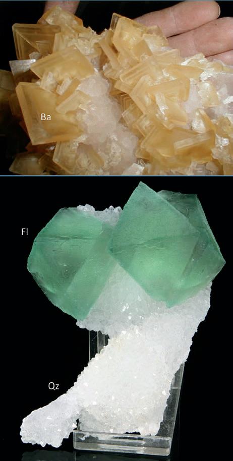
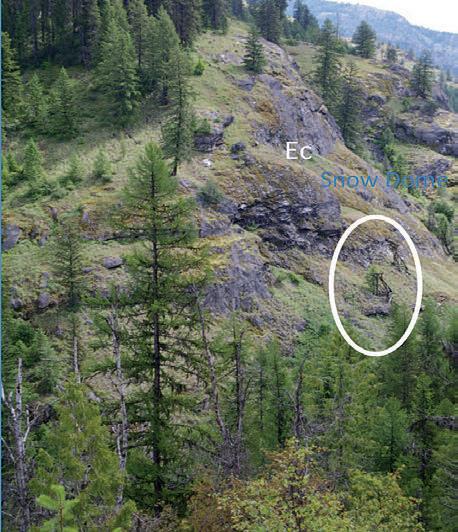
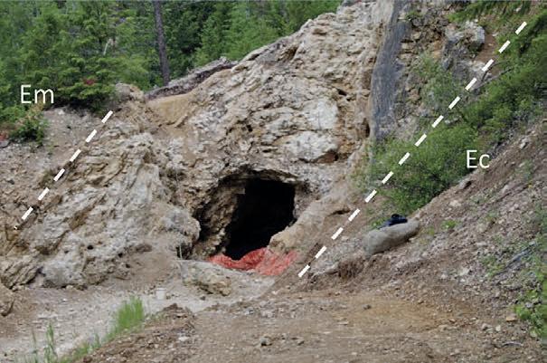
The RC mine exploited an epithermal vein within a north-northeast oriented fracture system. The vein varies from 1-10m in width and extends over 1 kilometre before pinching out. It has been mined about 150 m in and to a depth of over 100m. The vein mineralization consists primarily of fluorite, barite and drusy quartz. Another mineral present is the earthy, rust coloured goethite which is a oxidized replacement of pyrite. The vein itself is at the contact between Paleocene to Eocene Marron Formation volcanics (primarily andesite lava), and intrusive syenite of the Eocene aged Coryell Formation. Also, late Jurassic granodiorite of the Nelson Batholith outcrops on the south side of the valley at the viewpoint opposite the mine. The syenite intrusion contains barium rich orthoclase feldspars and its presence drove heated mineral laden fluids up dilatant fracture zones to the surface. At the mine site, this oxidized,
epithermal vein system filled with brecciated rubble from the surrounding rocks and then crystalline minerals derived from the cooling syenite sourced fluids began to precipitate. Minerals present at the mine include fluorite, quartz, calcite and barite and also clays (kaolinite, sericite) formed from altered feldspars (Dolmage, 1929). The angular breccia and gaps between are commonly lined with colourful white, pink, green and purple banded fluorite. While there is plenty to collect in the debris at the mine the best time to be there is when a new vug has been opened up. Vugs, large holes in the vein, are often lined with spectacular crystal clusters.
rEFE rE nCES :
Allen, Robert D., 1952. Variations in Chemical and Physical Properties of Fluorite. (www.minsocam.org/ ammin/AM37/AM37_910.pdf)
Joel F. Cubley, David R.M. Pattison, 2012. Metamorphism and deformation of the Grand Forks complex: implications for the exhumation history of the Shuswap core complex, southern British Columbia CJES, 49(11): 1329-1363
Dolmage Victor 1929 Grand Forks mining district Rock Candy mine in Wilson ME Fluorspar deposits of Canada. GSC Survey Econ Geology ser vol 6 pp 22-28.
Jennifer Pell and Janet Fontaine, 1988. Fluorspar in British Columbia, in Industrial Minerals Studies. BCGS Field Work 1988. white, pink, green and purple. Pages 467-482.
Simandl, G.J. (2009): World Fluorspar Resources, Market and deposit examples from British Columbia, Canada; British Columbia Geological Survey, Information Circular 20094, 16 pages
 Top, prepared specimen of butterscotch yellow coloured barite and white, drusy quartz from a vug in the mine.
Photo permission of Harold Corbin. Bottom, prepared specimen of green fluorite and drusy quartz. Fluorite is colourful due to minor impurities (rare earth elements such as Sr and Y) and crystal lattice imperfections. It is also fluorescent (glows nicely in UV light) and typically forms cubic or octahedral crystals as in the depicted image.
Photo permission of Collector’s Edge Minerals, Golden, CO. Both specimens from the collection of Bob Jackson.
View northeast across the valley of Kennedy Creek, before final descent into mine. Remnants of mine infrastructure (conveyor towers) in white oval. Pink syenites (coloured by coarse orthoclase feldspar crystals ) of the Coryell Formation comprise the outcrop).
Top, prepared specimen of butterscotch yellow coloured barite and white, drusy quartz from a vug in the mine.
Photo permission of Harold Corbin. Bottom, prepared specimen of green fluorite and drusy quartz. Fluorite is colourful due to minor impurities (rare earth elements such as Sr and Y) and crystal lattice imperfections. It is also fluorescent (glows nicely in UV light) and typically forms cubic or octahedral crystals as in the depicted image.
Photo permission of Collector’s Edge Minerals, Golden, CO. Both specimens from the collection of Bob Jackson.
View northeast across the valley of Kennedy Creek, before final descent into mine. Remnants of mine infrastructure (conveyor towers) in white oval. Pink syenites (coloured by coarse orthoclase feldspar crystals ) of the Coryell Formation comprise the outcrop).
22 RESERVOIR ISSUE 7 • JULY/AUGUST 2013
View at mine entrance, where the vein system is about 6m wide. The vein runs between heavily altered Marron Formation volcanics (Em) and Coryell syenite.
Mine cart along the trail, surrounded by forest overgrowth and blooms of wild rose.
Heavily altered Marron Formation andesite in the west wall of the vein. Orange lined fractures are goethite. Most of the original rock has been alternated to sericite ad kaolinite clays.
Rounded clasts of altered Marron volcanics with surrounding space filled by fluorite and quartz.
Purple and pale green fluorite crystals capped with white tabular barite crystals (green arrow) and a final coating layer of radiating acicular quartz crystals (white arrow). The contact between the fluorite and barite (dashed line) shows some rounding and possible partial dissolution of the fluorite crystals but elsewhere the fluorite exhibits angular faces.
vein
Closeup of breccia with fluorite filled fracture (arrow) indicating that alteration of the Marron volcanics was an ongoing process. Continued alteration might ultimately result the originally angular clasts taking on a more rounded aspect as in the image to the left.
The Reservoir Committee welcomes contributions from our readership to this series. If you wish to offer a submission to Go Take a Hike on your favourite hike of geological interest, email the Reservoir at Emma.MacPherson@cspg.org for more information.
Columbia Lily being visited by a Canadian Tiger Swallowtail butterfly.
Angular
breccia coated with green and purple zoned fluorite and minor quartz. The colour zonation in fluorite is likely triggered by variations in composition of dissolved in minerals in hydrothermal fluids.
RESERVOIR ISSUE 7 • JULY/AUGUST 2013 23
GO TAKE A HIKE Preglacial channel near Heritage Ranch, Red Deer, AB
| By Jared Fath and Len Hills
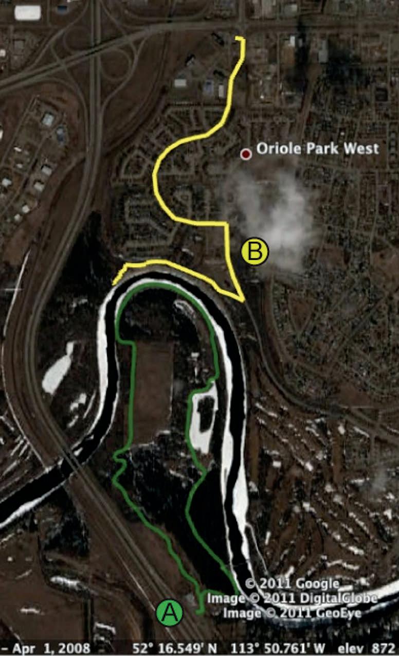
Things to bring: Hiking Boots, Binoculars, Water
Expected time: 2-3 hours, round trip (South) 4.5km
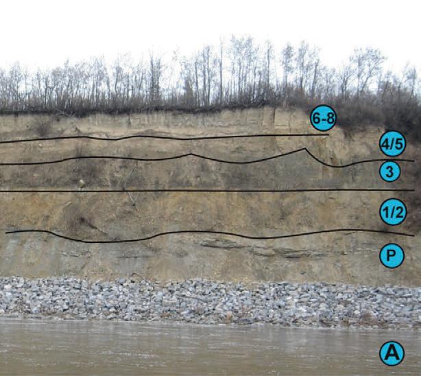
There is an excellent example of a buried pre-glacial valley in Red Deer, just off the QE II highway. Pre-glacial valleys were first observed in Western Canada by G.M. Dawson, and R.G. McConnell in the late 1800s. These were often found in cutbanks of present-day rivers. These ancient valleys are exposed in the valley walls incised in bedrock, typically of Cretaceous or Paleocene age, and covered by glacial tills. In Red Deer a deep, wide channel has been cut into Paskapoo sands and shales of Paleocene age (65-56 million years old). This channel is filled with pre-glacial (21,000-42,000 years old) sands and gravels and topped up by glacial and glaciolacustrine units. The basal fills of valleys like this one have historically been used for aggregate and as high-yielding aquifers and contain a mid-Wisconsinan paleofauna.
The outcrop may be accessed via Heritage Ranch or the Oriole Park West subdivision. To get an overview of the buried valley (A), park at the Heritage Ranch directly off the QEII highway. Take the footpath over the bridge and cross over onto a horse trail. Follow the horse trail to a large open field. Continue to the end of the field and turn left along one of the small horse trails branching off the large gravel horse trail. Following these trails one can reach the edge of the river and begin following the inner meander bend of the river from west to east. While on your way back you can examine an abandoned sandstone quarry on the East of the river bend. This route is fairly easy to walk, and affords many excellent views of the preglacial channel exposed on the opposite bank.
Background
by Astrid Arts.
Photo
Map of Trails: (A) Southern trail. (B) Northern outcrop trail.
24 RESERVOIR ISSUE 7 • JULY/AUGUST 2013
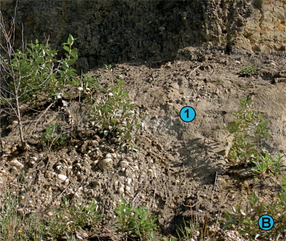
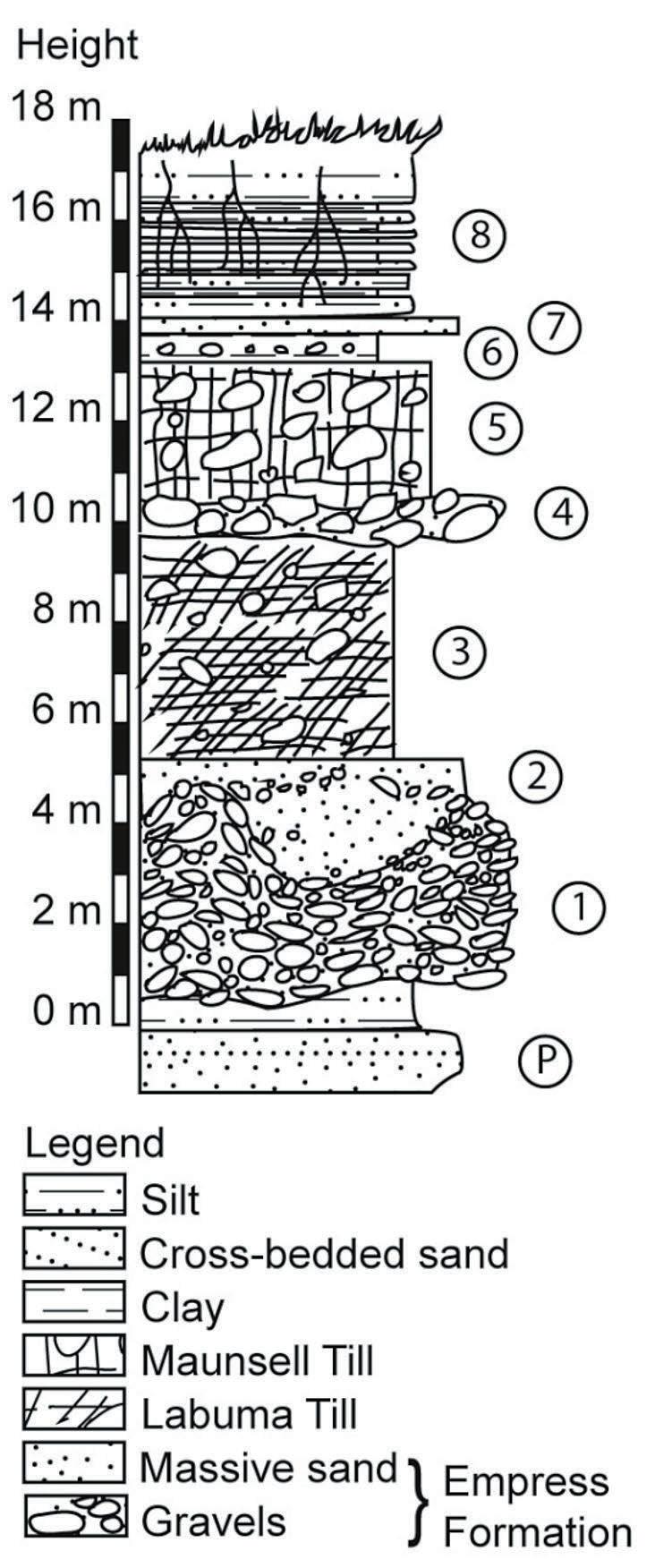
(A) View of paleochannel showing (P) Paskapoo Formation (1/2) Empress Formation gravels and sands (3) Labuma Till (4/5) occasional debris flow with Maunsell Till overlying (6-8) Glacial Lake Red Deer sediments. (B) Close-up of Empress Formation showing (1) pebble involutions into sand layer.
Alternatively (B), you can turn off the QEII at 67th street and immediately turn right at the Tim Horton’s restaurant. From the Tim Horton’s follow Orr Drive to a T-intersection at Oak Dr. Turn right at Oak Drive and follow until reaching a parking lot by a park. From there you can follow a paved path skirting the top of the cutbank turning off into a gravel path part way down in order to find a set of stairs leading down to the river path. This path allows direct access to the cutbank, however caution is advised as rip-rap has been placed on the cutbank to prevent erosion. This has the effect of both damaging the outcrop, and making footing quite treacherous. Nevertheless you can get some excellent closeup outcrop such as those below. This is a worthwhile trip for those interested in the glacial history of Alberta, its buried valley aquifers and Pleistocene palaeontology.
rEFE r E n CES : Stalker, A.M., 1960. Surficial Geology of the Red Deer maparea, Alberta. Memoir 306, Geological Survey of Canada.
Rutter, N.W., Andriashek, L.D., and Fenton, M.M. 1998. Engineering geology of Edmonton, Alberta. In Urban Geology of Canadian Cities, GAC Special Paper 42. pp. 71-92.
Westgate, J.A. and Bayrock, L.A. 1964. Periglacial structures in the Saskatchewan gravels and sands of central Alberta, Canada, The Journal of Geology, 72: pp. 641648.
The Reservoir Committee welcomes contributions from our readership to this series. If you wish to offer a submission to Go Take a Hike on your favourite hike of geological interest, email the Reservoir at Emma.MacPherson@cspg.org for more information.
Image to the left: Units: (8) Glaciolacustrine silt and clay varves with roots (7) Ripple cross-laminated glaciolacustrine sands (6) Red and tan glaciolacustrine clays (5) Maunsell Till (may rest directly on Labuma below) (4) Sand and gravel debris flow (local) (3) Labuma Till (2) Empress Formation sands (1) Empress Formation Gravels (P) Paskapoo Formation Bedrock
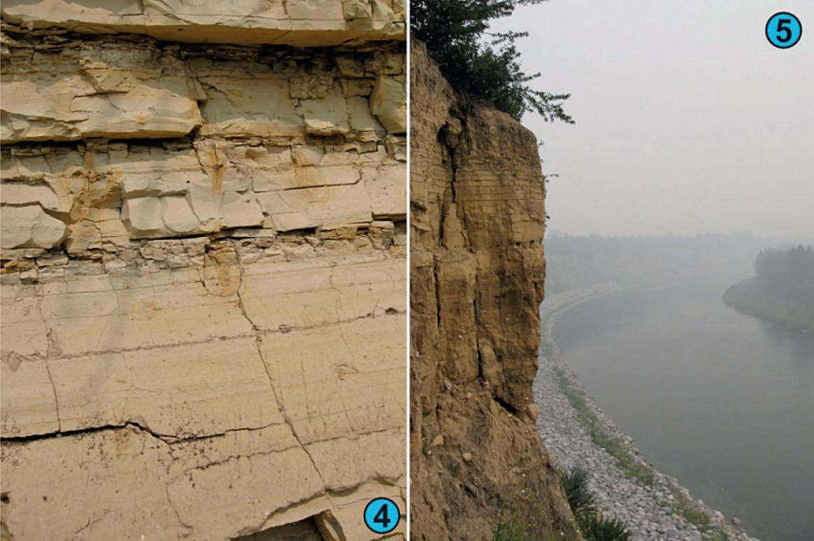
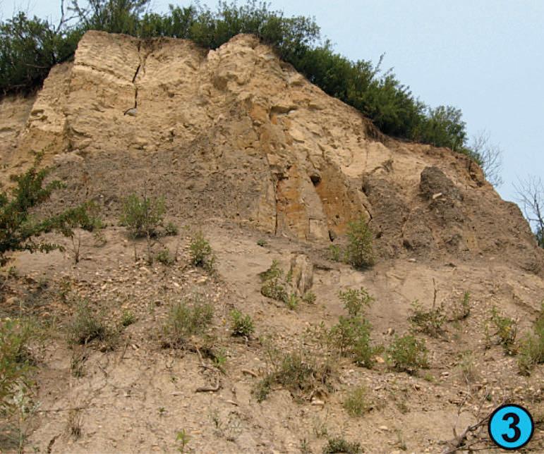
(3) Looking upward at valley-fill, glacial and glaciolacustrine sediments.(4) Detail of clay and post-depositional roosilt varves showing t haloes. (5) Sheer cliffs of Maunsell Till and Lake Red Deer Sediments.
RESERVOIR ISSUE 7 • JULY/AUGUST 2013 25
LOOKING FOR A SSISTANCE with Go Take a Hike Book
CSPG Members you may have read (and hopefully enjoyed) the Go Take a Hike Series in the CSPG Reservoir. This monthly series is currently being edited for a CSPG Special Publication in memory of the late Dr Cynthia Reidiger. All profits will go to a charitable cause. We have over 60 hikes submitted by a variety of authors which will be either within the book or the associated CD. As Chair of the Cindy Reidiger Memorial Book Committee I would like to invite you to assist us in one of several forms:
Submit photos to supplement the existing articles: The authors who researched the hikes sometimes did so out of season or during inclement weather. Because of this not all of the photos are necessarily in the best lighting conditions. If you think you have some high quality (and high resolution images) from the table of hikes below then please contact me (before sending photos).
Submit an article (or photos to assist in the creation of an article) for
publication in the Reservoir… and in the CD if received early enough (August). I can provide instructions on format. Examples of hikes I would love to see someone write about:
• Strom atolites and pillow lavas of Drywood Creek in SW Alberta.
• Belly River at Lundbreck Falls.
• Crowsnest Volcanics, SE Alberta.
• The Ge ology of Cypress Hills, SE Alberta.
• Wood Buffalo National Park (karst and salts).
• Devil’s Coulee Dinosaur Egg Site, Warner, Alberta.
• Milk R iver Dikes / Black Butte, SE Alberta.
• Red Rock Coulee, SE Alberta.
Join the committee (lots of roles with varying levels of commitment)
a ssis t in editing.
Donate funds to offset the cos t of printing the book, or fundraise through corporate sponsorship (either in the
GEOEDGES INC.
form of funds or commitment to purchase a number of copies of the book).
If you think you have a photo you would like to submit please contact me first and I will let you know what our specific needs are. I can be reached at by phone (403)-691-3343 or email Philip.Benham@ shell.com. Please be aware that you will be given appropriate credit if your photos or articles are used but we cannot provide payment. I will be happy to provide a pdf of the hike in which your photo is used, upon its completion. Some considerations for photo submissions: looking for attractively set and lit photos with geological features figuring prominently. A person for scale may be okay but people in general shouldn’t figure prominently in the photo. The images must be high resolution or they won’t portray well in print.
Table of the hike articles (page 26) in progress (in no particular order and currently in varying state of completeness)
Detailed and accurate geology at your fingertips in Petra, GeoGraphix, ArcGIS, AccuMap, GeoScout and other applications for information contact:
Western Canada: Slave Point, Swan Hills, Leduc, Grosmont, Jean Marie, Horn River Shales, Elkton, Shunda, Pekisko, Banff, Mississippian subcrops and anhydrite barriers in SE Sask., Bakken, Three Forks, Montney, Halfway, Charlie Lake, Rock Creek, Shaunavon, BQ/Gething, Bluesky, Glauconitic, Lloyd, Sparky, Colony, Viking, Cardium, Horseshoe Canyon and Mannville CBM, Oilsands Areas, Outcrops
Northern US Rockies & Williston Basin Geological Edge Set
Western Canada Geological Edge Set
North American Shales Geological Edge Set
Eastern US / Appalachian Basin Geological Edge Set
Texas & Midcontinent US Geological Edge Set
US Rockies & Williston: Red River, Mississippian subcrops & anhydrite barriers (Bluell, Sherwood, Rival, etc), Bakken, Three Forks, Cutbank, Sunburst, Tyler, Heath, Muddy, Dakota, Sussex, Shannon, Parkman, Almond, Lewis, Frontier, Niobrara, Mesaverde shorelines, Minnelusa, Gothic, Hovenweep, Ismay, Desert Creek, Field Outlines, Outcrops
Texas & Midcontinent: Permian Basin paleogeography (Wolfcampian, Leonardian, Guadalupian), Granite Wash, Mississippian Horizontal Play, Chat, Red Fork, Morrow, Sligo/Edwards Reefs, Salt Basins, Frio, Yegua, Wilcox, Eagleford, Tuscaloosa, Haynesville, Fayeteville-Caney, Woodford, Field Outlines, Outcrops, Structures
North American Shales: Shale plays characterized by O&G fields, formation limit, outcrop, subcrop, structure, isopach, maturity, stratigraphic cross-sections. Includes: Marcellus, Rhinestreet, Huron, New Albany, Antrim, Utica-Collingwood, Barnett, Eagleford, Niobrara, Gothic, Hovenweep, Mowry, Bakken, Three Forks, Monterey, Montney, Horn River, Colorado
Eastern US / Appalachia: PreCambrian, Trenton, Utica-Collingwood, Medina-Clinton, Tuscarora, Marcellus, Onondaga Structure, Geneseo, Huron, Antrim, New Albny, Rhinestreet, Sonyea, Cleveland, Venango, Bradford, Elk, Berea, Weir, Big Injun, Formation limits, Outcrops, Allegheny Thrust, Cincinatti Arch, Field outlines
Deliverables include:
-Shapefiles and AccuMap map features
-hard copy maps, manual, pdf cross-sections
-Petra Thematic Map projects, GeoGraphix projects, ArcView map and layers files
-bi-annual updates and additions to mapping
-technical support
26 RESERVOIR ISSUE 7 • JULY/AUGUST 2013
Joel Harding at 403 870 8122 email joelharding@geoedges.com www.geoedges.com
H IKES ToPIC
Alderson-Carthew Trail, Waterton Pc-C Age Strata
Athabasca Falls, Jasper Gog And Erosion
Athabasca Glacier, Jasper Glaciation
Banff Hoodoos Trail Hoodoo Formation
Big Hills Springs, Cochrane Tufa Deposits
H IKE S ToPICS
Kicking Horse River, Yoho Braided Streams
Lake Minnewanka, Banff Paleozoic Stratigraphy
Marble Canyon/Paint Pots, Kootenay Erosion / Mineral Springs
Medicine Lake, Maligne Canyon, Jasper Karst And Erosion
Moose Ck, Near Golden BC Ice River Igneous Complex
Blindman River, Alberta Paskapoo Fm And FossilsMount Stephen, Yoho Paleontology
Bow Glacier Falls, Banff Dolomization
Brewer Creek, BC Snowball Earth
Bugaboo Mountains, BC Granite
Buller Pass, Kananaskis Paleozoic Stratigraphy
Mount Yamnuska Structural Geology Structural Geology
Mt Edith Cavell, Jasper National Park Gog Gp / Glaciation
Muskeg Falls, Grande Cache Cretaceous Stratigraphy
Natural Bridge, Yoho Structural Geology
Canyon Creek, Kananaskis Paleozoic Stratigraphy Nihahi Ridge, Kananaskis Paleozoic Stratigraphy
Seebe Dam Cardium Picklejar Lakes, Kananaskis P-Tr Stratigraphy
Drumheller Hoodoos, Willow Creek Bearpaw Sea
Edworthy Park, Calgary Mass Wasting
Elbow Lake-Sheep Lakes Paleozoic Stratigraphy
Plain Of The Six Glaciers, Lake Louise Cambrian Strat / Glaciation
Plateau Mt, Kananaskis Permafrost Features
Prairie Mountain, Kananaskis Structural Geology
Emerald Basin Trail, Yoho Cambrian Stratigraphy Ptarmigan Cirque, Kananaskis Paleozoic Stratigraphy
Empress Formation, Red Deer Pleistocene Stratigraphy Radium Hotsprings, BC Structural Geology / Stratigraphy
Frank Slide Mass Wasting
Glacial Erratics Calgary To Okotoks Glacial Erratics
Ram Falls Prov Park Structural Geology
Rats Nest Cave, Exshaw Caves
Grassi Lakes, Canmore Devonian Strat / Vugs Mt Sarrail, Kananaskis Structural Geology
Grassy Mt, SW AB Cretaceous Stratigraphy
Grotto Canyon Structural Geology
Hailstone Butte, Livingstone Range Structural Geology
Red Rock Canyon, Waterton Cambrian Stratigraphy
Rock Candy Mine, Greenwood BC Hydrothermal Alteration
Sandy Point, SE Alberta Cretaceous Stratigraphy
Head Smashed In Buffalo Jump Provincial Park Paleocene Stratigraphy Sentinel Pass, Banff Cambrian Stratigraphy
Headwall Lakes, Kananaskis Paleozoic-Triassic Stratigraphy
Helen Lake, Banff Stromatolites
Hell’s Gate, Grande Cache Cadomin Fm
Skoki Lodge Trails Banff National Park Cambrian Stratigraphy
Snowbird Pass, Mt Robson National Park Cambrian Stratigraphy
Tunnel Mountain Drive, Banff Pt Boundary
Horseshoe Canyon, Drumheller Cretaceous Stratigraphy Upper Kananaskis Lake Paleozoic Stratigraphy
Johnston Canyon, Banff Paleozoic-Triassic Stratigraphy Walcott Quarry (Burgess Shale) Paleontology
Jura Creek Source Rocks Whaleback Ridge, Yoho Paleozoic Stratigraphy
Karst Springs, Kananaskis Springs
Kicking Horse Mines, Yoho Pb-Zn Mineralization
Writing On Stone Cretaceous Stratigraphy
Yoho Glacier, Banff National Park
Dolomitization Processes
RESERVOIR ISSUE 7 • JULY/AUGUST 2013 27
SOFT SKILLS
PRODUCTION
GENERAL GEOSCIENCES
CLASTIC OIL SANDS CARBONATES
2013
cSPg
LocationTitle Authors Nb Days Dates Member Cost (CAD)* Downtown Calgary Networking: Real World & Real Time Connections - Creating Powerful New Circles of Influence Bruce Lee 1d Oct 24 350 LocationTitle Authors Nb Days Dates Member Cost (CAD)* Downtown Calgary Drilling & Production Fundamentals David Hill 2d Oct 21-22 950 LocationTitle Authors Nb Days Dates Member Cost (CAD)* Downtown Calgary Conflict Resolution within the Realm of Oil & Gas Negotiations David Hill 2d Oct 23- 24 950 Downtown Calgary Fluvial Stratigraphy John Holbrook 2d Oct 23-24 1,050 LocationTitle Authors Nb Days Dates Member Cost (CAD)* Field Seminar Stratigraphy and Hydrocarbon Systems of the Sappington (Bakken/Exshaw) and Three Forks Formations in Western Montana** Ted Doughty George Grader 3d Jul 25-27 1,500 LocationTitle Authors Nb Days Dates Member Cost (CAD)* Field Seminar Stratigraphy and Hydrocarbon Systems of the Sappington (Bakken/Exshaw) and Three Forks Formations in Western Montana** Ted Doughty George Grader 3d Jul 25-27 1,500 ERCB Core Mannville Stratigraphy, Sedimentology and Petroleum Geology Doug Cant 3d Oct 16-18 1,775 ERCB Core Subsurface Methods In Clastic Sediments Doug Cant 2d Oct 21-22 1,000 ERCB Core Rock Creek Stratigraphy, Sedimentology and Petroleum Geology Doug Cant 1d Oct 25 625 LocationTitle Authors Nb Days Dates Member Cost (CAD)* Downtown Calgary Practical Geomechanics for Unconventional Oil and Gas Pat McLellan 2d Oct 16-17 1,500 LocationTitle Authors Nb Days Dates Member Cost (CAD)* Field Seminar Geology of the Athabasca Oil Sands Murray Gingras & Mike Ranger 3d Sep 5-7 3,650 Field Seminar Glacial sedimentology for oil sands geologists Nick Eyles 3d Sep 11-13 1,490 Field Seminar Gironde estuary and Aquitaine coast field trip: modern environments and reservoir characterization Hugues Fenies 4d Sep 17-20 3,400 SOFT SKILLS PRODUCTION GENERAL GEOSCIENCES CLASTIC OIL SANDS CARBONATES SHALE GAS 2013 EDUCATION PROGRAM CSPG PROFESSIONAL DEVELOPMENT * + CAD125 for Non-member ** Course listed both under Clastic and Carbonates Latest update: www.cspg.org LocationTitle Authors Nb Days Dates Member Cost (CAD)* Downtown Calgary Networking: Real World & Real Time Connections - Creating Powerful New Circles of Influence Bruce Lee 1d Oct 24 350 LocationTitle Authors Nb Days Dates Member Cost (CAD)* Field Seminar Drilling and Production; a Trip to a Working Drilling Rig and Production Facilities David Hill 1d June 7 550 Downtown Calgary Drilling & Production Fundamentals David Hill 2d Oct 21-22 950 LocationTitle Authors Nb Days Dates Member Cost (CAD)* Field Seminar Geology for non Geologists Jon Noad 1d June 20 350 Downtown Calgary Conflict Resolution within the Realm of Oil & Gas Negotiations David Hill 2d Oct 23- 24 950 Downtown Calgary Fluvial Stratigraphy John Holbrook 2d Oct 23-24 1,050 LocationTitle Authors Nb Days Dates Member Cost (CAD)* Field Seminar Stratigraphy and Hydrocarbon Systems of the Sappington (Bakken/Exshaw) and Three Forks Formations in Western Montana** Ted Doughty George Grader 3d Jul 25-27 1,500 LocationTitle Authors Nb Days Dates Member Cost (CAD)* Field Seminar Contrasting the Reservoirs of Braided and Meandering depositional systems Jon Noad1.5dJune 12 pm-13 540 Field Seminar Tide-Dominated Depositional Environments in the Bay of Fundy, Canada Murray Gingras Shahin Dashtgard 4d June 12-15 2,650 Field Seminar Stratigraphy and Hydrocarbon Systems of the Sappington (Bakken/Exshaw) and Three Forks Formations in Western Montana** Ted Doughty George Grader 3d Jul 25-27 1,500 Field Seminar Subtidal Sandbodies Heterogeneity and Sequence Stratigraphic Distribution in the Gog Group of the Southern Canadian Rockies: Insights for Reservoir Modelling Patricio Desjardins Luis Buatois 3d Sep 4-6 1,775 ERCB Core Mannville Stratigraphy, Sedimentology and Petroleum Geology Doug Cant 3d Oct 16-18 1,775 ERCB Core Subsurface Methods In Clastic Sediments Doug Cant 2d Oct 21-22 1,000 ERCB Core Rock Creek Stratigraphy, Sedimentology and Petroleum Geology Doug Cant 1d Oct 25 625 LocationTitle Authors Nb Days Dates Member Cost (CAD)* Field Seminar SAGD Fundamentals - Field Seminar in Fort McMurray, Alberta R. Strobl, M.Fustic & D.Wightman 2d June 18-19 1,950 Field Seminar Geology of the Athabasca Oil Sands Murray Gingras & Mike Ranger 3d Sep 5-7 3,650 Field Seminar Glacial sedimentology for oil sands geologists Nick Eyles 3d Sep 11-13 1,490 Field Seminar Gironde estuary and Aquitaine coast field trip: modern environments and reservoir characterization Hugues Fenies 4d Sep 17-20 3,400
Education Program
ProFESSionaL dEVELoPmEnt
2012 CSPG TRACKS AwARD Formal Citation
nathan Bruder has been an active member of the CSPG since 1997. His volunteer experience within the organization has been highly varied, ranging from Short Courses facilitator at geoConvention 2000 to coChair of the 2010 AAPG ICE Convention Core Conference. Most recently he held the position of Technical co-Chair geoConvention 2012. Nathan received a B.Sc. in Geology from the University of Alberta in 2000 and is currently employed as a Staff Exploration Geologist with Murphy Oil Corporation.
Jon Coady graduated from the University of Calgary in 1993 with a M.Sc in geochemistry. Jon st arted in the industry with specialized consulting firms – firstly at Rakhit Petroleum Consulting doing mineral exploration, hydrogeology and geochemistry and then moved to Petrel Robertson to work on regional exploration studies, petrography and core-based sedimentology.
In 1999, Jon started with PanCanadian/ EnCana firstly to work oilsands at Christina Lake development and then international exploration in Ecuador. After a brief stop at EOG, Jon got to work and drill wells in the Beaufort Mackenzie with MGM Energy and now at Statoil Canada working East Coast exploration in the Jeanne d’Arc and Flemish Pass.
Tom Sneddon has been a loyal member of the CSPG since 1967, initially as a student member. His geoscience career began with Pan American Petroleum (later called Amoco) as a Geophysical Professional Assistant. Later, thanks to an excursion into applied research with several agencies of the Alberta Government, he got involved with a broad range of geoscience disciplines, with publications in experimental watershed research, hydrology, hydrogeology, environmental geology and geophysics. As a private consultant, he applied his expertise to oil and gas prospect development, drilling programs, and extensive field work in minerals exploration and development.
Today, Tom is the Director of Geoscience and Outreach for APEGA.
In this role, Tom is committed to help raise the standards of professionalism within Alberta applied geosciences. His APEGA mandate is to:
• Write regular articles on topics related to geoscience professionalism, in publications the RECORDER, The Source, the RESERVOIR, and the PEG. He occasionally also writes for engineering publications and addresses engineering audiences.
• Meet and interacting with geoscience and engineering students.
• Speak at professional and student events such as CSPG luncheons, GeoSkills, CAGC’s Seismic in Motion, the Alberta Student Energy Conference, the Honorary Address, and Geoconvention to promote professionalism by the applied geoscience and engineering communities.
• Sponsor academic and industry events
• Act as the liaison between APEGA and both industry and the four Alberta universities.
Someday he hopes to retire, but right now he is having too much fun working with his geoscience colleagues of all ages.
m icha el l aBerg e has been a member of the CSPG since 1983. He was a member of the Advisory Committee for the CSPG Advantage Program in 19941995 – an education program providing explorationists with advanced geology training courses for specific Stratigraphic units in the Western Canada Sedimentary Basin. The initial five courses included the Regional Geology and Exploration Models in the WCSB, The Triassic, Winterburn, Mississippian and the Lower Cretaceous Mannville Group. He has been involved with the annual CSPG Classic Golf Tournament since 1995 and Chairman of the Committee for the past 6 years.
Michael views these social events as an integral part of the CSPG service to its members by bringing geoscientists, managers and service industry personnel together in a business/social networking environment. The Classic celebrates its 53rd tournament in June 2013. Michael received his Bachelor of Science (Honours) in Geology and Biology from Dalhousie University in 1977, with a focus on sedimentary geology and oceanography. He has 36 years of prospect generation and asset development in clastics and carbonates within domestic and international basins. He has been an explorationist and manager within multinational and junior oil & gas companies, and operated a proprietary consulting company for 19 years. He assisted with the Belize Modern Carbonates Field Trip and Workshop from 1997 to 2000. Michael is currently a Senior Exploration Geologist with Surge Energy Inc.
(Continued on page 30...)
RESERVOIR ISSUE 7 • JULY/AUGUST 2013 29
Nathan Bruder
Jon Coady
Tom Sneddon
Michael LaBerge
CORPORATE SUPPORTERS
AGAT Laboratories
Apoterra Seismic Processing Ltd.
ARC Resources Ltd.
Arcis Seismic Solutions
Cabra Consulting Ltd.
Canadian Natural Resources Ltd.
CGG Veritas Services Inc.
Compass Directional Services
Continental Laboratories Ltd.
Cossack Land Services Ltd.
Crescent Point Energy Trust
Datalog Technology Inc.
Edge Technologies Inc.
Exova Canada Inc.
Explor
GeoTir Inc.
GLJ Petroleum Consultants Ltd.
IHS
Kulczyk Oil Ventures
LXL Consulting Ltd.
McDaniel & Associates Consulting Ltd.
MOH & Associates Oilfield Consultants
National Oilwell Varco
Nickpoint Environmental Services
Olympic Seismic Ltd.
Paradigm Geophysical Corp.
Pason Systems Corp.
Perpetual Energy Inc.
Pioneer Professional Group
Pro Geo Consultants
ProActive Health
Pulse Seismic
Regent Resources Ltd.
Rigsat Communications
RPS Energy Canada Ltd.
SAExploration
SeisWare
Sensor Geophysical Ltd.
Sigma Explorations Inc.
Sourcex
Total Gas Detection Ltd.
Trident Exploration Corp.
Western Geco
AS OF JUNE 10, 2013
CSPG welcomes our 2013 Corporate Supporters! The benefits of being a corporate member include:
• Recognition in the monthly Reservoir and quarterly Bulletin
• One associate membership
• Reserved tables at the technical luncheons with your company logo
• One free pass to the CSPG Core Conference
…and more! Contact Kasandra Klein at kasandra.klein@cspg.org to be a corporate member today!
Philip Benham has been the CSPG Paleontology Division Chair for thirteen years. In that role he has arranged and hosted approximately 140 lectures and chaired 9 consecutive paleontology conferences that were free and open to CSPG members and the general public. He has written numerous articles for the CSPG Reservoir including many in the Go Take A Hike Series (which attempt to provide geological information on popular outdoor destinations near Calgary and around the world). He is currently chairing the Cindy Riediger Memorial Book Committee into which many of these hike articles will be edited and compiled as a CSPG Special Publication. He also is on the Board of Directors for the Burgess Shale Geoscience Foundation and has been involved with that organization for many years developing educational material for science teachers and running workshops that provide them the tools to excite their students in the world around them. He is widely travelled (with a preference for unusual places), which combines with his passion for photography and public education to give talks to a variety of organizations on how geology impacts us on this planet. He received his B.Sc. from the University of British Columbia and his M.Sc. in Geology from Memorial University of Newfoundland and is currently Regional Discipline Advisor for Production Geology at Shell Canada.
Ben m cKenzie began volunteering with the CSPG in 1991, helping develop a consultant’s directory and, later, publishing a series of stratigraphic correlation charts of Alberta in 1992. Through the ‘90s and early 2000s, he was active with the Canadian Gas Potential Committee, which began as a CSPG committee. In 2003, Ben became the Technical Editor for the Reservoir and served in that position until 2013. In 2009, he also stepped in as Chair of the Digital Atlas Committee and was instrumental in advancing that project further down the road to implementation.
Ben was born and grew up in WinstonSalem, North Carolina. He moved to Raleigh to study electrical engineering at North Carolina State University, but quickly realized geology was a much more interesting path. After graduation, he began work with the State Geological Survey and continued his studies as a part-time graduate student. In 1981, he was hired by Gulf Canada and moved to Calgary. Since 1991, he has worked on staff or as a consultant for a number of petroleum and service companies, while also obtaining a Master’s in Geographic Information Systems. Since 2010, Ben has been consulting with Canadian Discovery on a variety of projects.
In addition to the CSPG, Ben’s volunteer activities have included working over 20 years in community theatre as a technician / stage carpenter and serving six years on the Parent Sponsoring Committee of the 781 ‘Calgary’ Squadron Air Cadets. He also worked with the Canadian Gas Potential Committee in various capacities on all three of their reports.
30 RESERVOIR ISSUE 7 • JULY/AUGUST 2013
Philip Benham
(...Continued from page 29)
Ben McKenzie
Building
The FuTure , Today


If you could find a way to attract vibrant, smart young people into our professions … would you?
If you could ensure those with the desire and drive to succeed have access to quality education … would you?
Yes? Then support the APEGA Education Foundation and remove barriers, open doors and encourage new Members into the geoscience and engineering professions.
The APEGA Education Foundation provides an easy and effective means for you as an APEGA Member to invest in the future of your profession.
To donate or for more information visit www.apega.ca/ educationfoundation
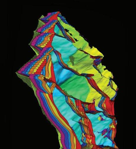
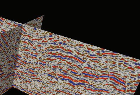
Blueback Reservoir the preferred and chosen GeoScience Solutions Partner Try something new. Find something better. Blueback Rock Physics plug-in for Petrel* Bridging the gap between geology and geophysics The complete suite of rock physics tools for quantitative interpretation across multiple domains within Petrel. Blueback Reservoir blueback-reservoir.com E sales@blueback-reservoir.com | T +1 403 538 4821 blueback-reservoir.com/rockphysics *Mark of Schlumberger 40005000 6000 8000900010000 11000 12000 7000 13000 1400015000 16000 Acoustic impedance (kP a.s/m) 17000 1.4 1.5 1.7 1.6 P/S velocity ratio 1.8 1.9 2.0 2.1 2.2 2.3 2.4 2.5 2.6 2.7 2.8 Por=0.4 Por=0.35 Por=0.3 Por=0.25 Por=0.2 Por=0.15 Por=0.1 Vol shl=0.6 Vol shl=0.4 Vol shl=0.2 Reservoir Properties
Petrel
Wells
