

17 Horizontal Drilling in Western Canada Part 6: Estimating Resources and Reserves 21 Wellsite Geology 24 Go Take a Hike $10.00 MARCH 2013 VOLUME 40, ISSUE 3 Canadian Publication Mail Contract – 40070050


> GEOSCIENCE SOFTWARE
> CRITICAL INFORMATION
> CONNECTED WORKFLOWS


CONNECTED AT E V ERY TOU CH P OI
N T


The IHS suite of geoscience software—which includes IHS Petra®, Kingdom®, LOGarc™ and GeoSyn™—is designed to seamlessly connect to the industry’s leading source of critical Oil & Gas information, eliminating the need to move data manually from source to source and project to project. With this powerful new combination, users can streamline data transfer, enhance database performance and simplify project sharing. The result? Workflows that connect like never before.
Connected workflows mean that IHS customers spend less time looking for data and more time looking for the next big opportunity. It’s just one of the many ways that IHS helps to advance the decisions that advance the Oil & Gas industry.
Find out more at IHS.com/geoscience

Streamline data transfer and simplify project sharing with IHS geoscience software and critical O&G information.
CSPG OFFICE
#110, 333 – 5th Avenue SW
Calgary, Alberta, Canada T2P 3B6
Tel: 403-264-5610
Web: www.cspg.org
Office hours: Monday to Friday, 8:30am to 4:00pm
Executive Director: Lis Bjeld
Tel: 403-513-1235, Email: lis.bjeld@cspg.org
Event Coordinator: Kelsey Green
Tel: 403-513-1225, Email: kelsey.green@cspg.org
Member Services:
Tel: 403-264-5610, Email: membership@cspg.org
Publications and Website: Emma MacPherson
Email: emma.macpherson@cspg.org, Tel: 403-513-1230
Programs Development: Aileen Lozie
Tel: 403-513-1227, Email: aileen.lozie@cspg.org
Database Administrator and Accounting: Kasandra Amaro
Maternity leave until January 2014
Corporate Sponsorship: Lis Bjeld
Tel: 403-513-1235, Email: lis.bjeld@cspg.org
Controller: Eric Tang
Tel: 403-513-1232, Email: eric.tang@cspg.org
EDITORS/AUTHORS
Please submit RESERVOIR articles to the CSPG office. Submission deadline is the 23rd day of the month, two months prior to issue date. (e.g., January 23 for the March issue).
To publish an article, the CSPG requires digital copies of the document. Text should be in Microsoft Word format and illustrations should be in TIFF format at 300 dpi., at final size. For additional information on manuscript preparation, refer to the Guidelines for Authors published in the CSPG Bulletin or contact the editor.
Technical Editors
Hugh S. Mosher Colin Yeo (Assistant Tech. Editor) Nunaga Resources Ltd. Encana Corporation M.: 403-809-9997 Tel: 403-645-7724
Email: hsmosher@telus.net Email: colin.yeo@encana.com
Coordinating Editor
Emma MacPherson, Publications Coordinator, CSPG Tel: 403-513-1230, emma.macpherson@cspg.org,
ADVERTISING
Advertising inquiries should be directed to Emma MacPherson, Tel: 403-513-1230 email: emma.macpherson@cspg.org. The deadline to reserve advertising space is the 23rd day of the month, two months prior to issue date.
The RESERVOIR is published 11 times per year by
Additional information on the RESERVOIR’s submission guidelines can be found at http://www.cspg. org/publications/pubs-reservoir-submissions.cfm. The contents of this publication may not be reproduced either in part or in full without the consent of the publisher. Additional copies of the RESERVOIR are available at the CSPG office. No official endorsement or sponsorship by the CSPG is implied for any advertisement, insert, or article that appears in the Reservoir unless otherwise noted. All submitted materials are reviewed by the editor. We reserve the right to edit all submissions, including letters to the Editor. Submissions must include your name, address, and membership number (if applicable). The material contained in this publication is intended for informational use only.
While reasonable care has been taken, authors and the CSPG make no guarantees that any of the equations, schematics, or devices discussed will perform as expected or that they will give the desired results. Some information contained herein may be inaccurate or may vary from standard measurements. The CSPG expressly disclaims any and
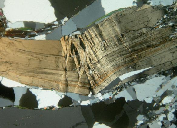
Cross-poloarized
RESERVOIR ISSUE 3 • MARCH 2013 3 MARCH 2013 – VOLUME 40, ISSUE 3 ARTICLES Horizontal Drilling in Western Canada Part 6: Estimating Resources and Reserves ................................................................ 17 Wellsite Geology ..................................................................................................................... 21 Go Take A Hike 24 49th Annual Western Inter-University Geoscience Conference (WIUGC) 27 Photo of the Month .............................................................................................................. 28 2012 Slipper Citation for Roger W. Smith ...................................................................... 29 DEPARTMENTS Executive Comment .......................................................................................................... 5 Technical Luncheons .......................................................................................................... 8 Division Talks 12 Continuing Education ...................................................................................................... 14 Rock Shop ........................................................................................................... 13, 20, 26 FRONT COVER
microphotograph of a deformed biotite porphyroblast from the Esplanade Range, S.E. British Columbia. This particular rock was sampled from the Neoproterozoic Horsethief Creek Group, which was deposited as turbidite sequences into a deep rift zone off the ancestral western margin of North America. Photo by Erik Parker.
the Canadian Society of Petroleum Geologists. This includes a combined issue for the months of July
August. The purpose of the RESERVOIR is to publicize the Society’s many activities and to promote the geosciences. We look for both technical and non-technical material to publish.
and
liability
third-party user
information contained in this publication. Under no circumstances shall the CSPG
its officers, directors, employees,
agents be liable for any injury, loss, damage,
expense arising in any manner whatsoever from the acts, omissions, or conduct of any third-party user. Designed and Printed by The Data Group of Companies, Calgary, Alberta.
all
for the acts, omissions, or conduct of any
of
and
and
or


They can copy us. They just can’t be us. If imitation is the sincerest form of flattery, we’re one flattered group. Drawing on a quarter century of oil and gas experience, geoLOGIC continues to be the market leader in data, software solutions and support. And while we lead the way, our competitors desperately create parity products, sometimes years after us. For details on how geoLOGIC leads the way, visit www.geoLOGIC.com/leader
gDC
gDCweb
petroCUBE
Leading the way with customer-driven data, integrated software and services for your upstream decision-making needs. geoSCOUT |
|
|
at www.geoLOGIC.com


CSPG EXECUTIVE
President
Paul MacKay • Shale Petroleum Ltd. paul.mackay@shalepetroleum.com Tel: 403.457.3930
Vice President
Dale Leckie • Nexen Inc. daleleckie@nexeninc.com Tel: 403.613.0458
Past President
Robin Mann • AJM Deloitte rcmann@deloitte.ca Tel: 403.648.3210
Finance director
Samantha Etherington • Barrick Energy SEtherington@barrick-energy.com Tel: 403.386.6459
assistant Finance director
Gord Stabb • Durando Resources Corp. gstabb@durando.ca Tel: 403.819.8778
Program director
Dave Russum • AJM Deloitte drussum@deloitte.ca Tel: 403.648.3228
assistant Program director
Alexis Anastas • Nexen Inc. alexis_anastas@nexeninc.com Tel: 403.699.4965
serVices director
Mike Seifert • Canadian Discovery mseifert@canadiandiscovery.com Tel: 403.269.3644
assistant serVices director
Weishan Ren • Statoil Canada Ltd. wren@statoil.com Tel: 403.724.0325
communications director
Curtis Evans • ERCB curtis.evans@ercb.ca Tel: 403.297.8386
assistant communications director
Riona Freeman • Harvest Operations Corp. riona.freeman@harvestenergy.ca Tel: 403.233.6624
outreach director
Dawn Hodgins • Imperial Oil Resources dawn.hodgins@exxonmobil.com Tel: 403.232.5931
assistant outreach director
Andrew Fox • MEG Energy Corp. andrew.fox@megenergy.com Tel: 403.770.5345
executiVe director
Lis Bjeld • CSPG lis.bjeld@cspg.org Tel: 403.513.1235
EXECUTIVE COMMENT
A message from Dave Russum, Director of Technical Programs

Quality and relevance in all that we provide
The New World order of oil and gas supply driven by horizontal drilling and multi-stage fracturing has created massive changes in our industry. The United States is speculating on future energy independence, implying huge challenges for Canada, our industry, and the CSPG. Providing our members with relevant information and forums for learning is a critical part of the CSPG’s responsibility in a changing world.
The Technical Program Portfolio is responsible for most of these learning initiatives – Continuing Education (Courses and Field Seminars), the Technical Divisions, CSPG Technical Luncheons and to a lesser degree the various CSPG sponsored Conferences.
Fortunately, we have many very capable individuals and committees who make things happen in their area of focus with minimal involvement of the Board. I thank all those individuals for their efforts and am available to provide support for the initiatives you may wish to undertake.
Much of the effort in 2012 has been devoted to improving the process for providing courses within the CSPG. Thanks to the efforts of Thomas Jerome and the Continuing Education Committee with the support of staff, we managed to get our 2013 education program published by December 1st 2012. Please check the CSPG website to see the variety of training courses we are offering and try to include at least one of them in your training plans for 2013.
I am delighted to welcome Alexis Anastas as Assistant Program Director this year. I know he will bring many new ideas to this portfolio. We are both committed to providing the most relevant, quality learning experiences to the membership.
It is important that we ensure the CSPG remains relevant. It is noticeable that we do not have an initiative that truly addresses the ‘unconventional’ developments in the petroleum industry. This is an area I want to address this year.
I foresee creating a forum that would bring together a broad cross section of the CSPG membership to discuss developments, advance ideas, and make presentations in an informal environment. It may foster mentoring, new contacts, the development of new divisions, joint problem solving, consensus building, or other initiatives within the CSPG. If you are interested in becoming involved or have a presentation you would like to share with your fellow members I would like to talk to you. Watch your email for more information.
2013 should be an exciting year. Please provide your feedback if there are types of learning or specific areas of our business where we should be expanding our programs for members or the industry at large.
RESERVOIR ISSUE 3 • MARCH 2013 5
Want to bring geology back into
geophysical interpretation?
All Aboard
Landmark’s new DecisionSpace® Desktop software accelerates seismic interpretation with geomodel-enabled workflows.
The geophysics and geology modules in Landmark’s new unified DecisionSpace® Desktop software share the same topology engine. This gives geophysicists easy access to framework construction tools that combine well picks and horizons to produce a high resolution, accurate geomodel. The geomodel uses conformance technology to produce well-based surfaces at the same resolution as seismic data, enabling a model that truly represents your reservoir. Get better answers faster. Visit halliburton.com/DecisionSpaceDesktop
High Science Simplified®

© 2013 Halliburton. All rights reserved.
CORPORATE SPONSORS
Diamon D
Geologic Systems Ltd.
Platinum
APEGA
Cenovus Energy
ConocoPhilips Canada
Nexen
GolD
Devon Energy Corp.
Encana Corporation
IHS
Imperial Oil Ltd.
PLS
Shell Canada Limited
Silv ER
Arc Resources
Athabasca Oil Sands Corporation
CSEG Foundation
CSPG Educational Trust Fund
Enerplus
EOG Resources
LED Signs
Roke Technologies Ltd.
TAQA North Ltd.
B Ronz E
AGAT Laboratories
Apache Canada
CNRL
Husky Energy Inc.
Loring Tarcore
Poggenpohl
RIGSAT Communications
RPS Energy
Schlumberger Canada Limited
Sensor Geophysical Ltd.
Suncor Energy
Talisman Energy
As of February 2013
A Special Thanks to Geologic Systems Ltd.,
C SPG ’s Top Sponsor of the Month
CSPG invites you to our Volunteer Appreciation Night
The strength of the Canadian Society of Petroleum Geologists has always been its volunteers and your service is a significant part of that foundation. Without you we certainly would not exist.
When: Thursday March 7th, 2013
Time: 4:30-6:30pm
Where: West Restaurant and Bar, 225 7 Ave SW (across from the SAIT Culinary Campus); +15 Level Room. Appetizers and a complementary drink will be provided.
Come meet our team of volunteers and learn how volunteering at CSPG has advanced careers, opened networking avenues and created lifelong friends.
This event will be hosted by President Paul MacKay and will be attended by the 2013 Executive Committee, committee chairs and all other volunteers. This event is meant to provide the much needed recognition to our volunteers as well as to recruit new volunteers for our many new opportunities available with the CSPG.
Thank you to our event sponsor:
RESERVOIR ISSUE 3 • MARCH 2013 7
Register for free online at www.cspg.org
technicaL Luncheons MARCH LUNCHEON
Mass balance effects in depositional systems
SPEAKER
Chris Paola
AAPG Distinguished Lecturer
11:30 am, tuesday, m arch 5, 2013
c algary te L us c onvention c entre
m acleod h all c / d, s outh Building c algary, a lberta
Please note: the cut-off date for ticket sales is 1:00 pm, thursday, February 28, 2013. csPg member ticket Price: $45.00 + gst. non-member ticket Price: $47.50 + gst.
Each CSPG Technical Luncheon is 1 APEGA PDH credit. Tickets may be purchased online at www.cspg.org.
Ab STRACT
Net deposition is accompanied by systematic loss of sediment mass from the transport system. How is this mass loss reflected in the deposits, and to what extent can it be used to predict stream-wise facies changes? We review mass-extraction analyses of laboratory experiments on fluvial channel stacking; experimental and field turbidites that show a change from channel-dominated to lobe-dominated deposits at about 80% total mass extraction; and experimental, theoretical, and field studies that show a close connection between rate of mass loss and rate of downstream grain-size fining. Applied thoughtfully, depositional mass balance provides a framework for quantitative prediction and comparison across basins of varying scale and shape.
bIOGRAPH y
Chris Paola is CSE Distinguished Professor of Earth Sciences, University of Minnesota, Minneapolis, and does research at St. Anthony
technicaL Luncheons MARCH LUNCHEON
Integrated, web-accessible, public-sector, geoscience mapping systems
SPEAKER
Harvey thorleifson Ph.D., P.Geo., D.Sc. Director, Minnesota Geological Survey; State Geologist of Minnesota; Professor, University of Minnesota
11:30 am
m onday, m arch 18, 2013 c algary te L us c onvention c entre m acleod h all c / d, s outh Building c algary, a lberta
Please note: the cut-off date for ticket sales is 1:00 pm, Wednesday, march 13, 2013.
csPg member ticket Price: $45.00 + gst. non-member ticket Price: $47.50 + gst.
Each CSPG Technical Luncheon is 1 APEGA PDH credit. Tickets may be purchased online at www.cspg.org.

AbSTRACT
Regional geological, geophysical, and geochemical surveys are a service provided by geological survey agencies at the federal and state/provincial level. This mapping represents authoritative lowresolution regional information regarding the properties, composition, structure, and origin of sediments and rocks, based on observations and inferences backed by research on material, process, and history. This spatial accounting is needed to provide context that supports the progress of both public and private sector applications related


Falls Laboratory. His research interests are in physical sedimentary geology and stratigraphy, especially the dynamics of channelized systems such as rivers and deltas. His education includes a B.S. in Environmental Geology from Lehigh University, a M.Sc. in Applied Sedimentology from University of Reading, and a D.Sc. in Marine Geology from the MIT/WHOI Joint Program in Oceanography.
Webcasts sponsored by
to energy, minerals, water, waste disposal, construction, and hazards as well as basic research. We are well into a transition from conventional paper reports and standalone databases, to web-accessible 3D geological mapping linked to geological, geophysical, and geochemical databases, supported by required documentation. This transition will accelerate, as users favour this format, and as geological survey agencies respond to societal needs.
bIOGRAPH y
Harvey Thorleifson was appointed Director of the Minnesota Geological Survey, State Geologist of Minnesota, and University of Minnesota Professor in 2003. He is 2012/2013 President of the Association of American State Geologists, he was the 2004/2006 President of the Canadian Geoscience Council, predecessor of the Canadian Federation of Earth Sciences, and he was the 2003/2004 President of the Geological Association of Canada. He is originally from western Manitoba; he completed his undergrad and Masters at the Universities of Winnipeg and Manitoba; he holds a Ph.D. from University of Colorado; and while with the Geological Survey of Canada from 1986 until 2003, he conducted field work at sites ranging from Alberta to offshore Hudson Bay.
8 RESERVOIR ISSUE 3 • MARCH 2013
Webcasts sponsored by
technicaL Luncheons APRIL LUNCHEON
The Cordilleran foreland thrustand-fold belt in southern Canada: Plate
tectonics, gravitational spreading, tectonic heredity, and mantle flow
SPEAKER
Raymond a . Price Professor Emeritus, Department of Geological Sciences & Geological Engineering, Queen’s University 11:30 am tuesday, april 09, 2013 calgary teLus convention centre calgary, alberta
Please note: the cut-off date for ticket sales is 1:00 pm, thursday, april 4, 2013. csPg member ticket Price: $45.00 + gst. non- member ticket Price: $47.50 + gst.
Each CSPG Technical Luncheon is 1 APEGA PDH credit. Tickets may be purchased online at www.cspg.org.
Ab STRACT
The east-verging foreland thrust-and-fold belt of the eastern Andes, which is actively growing now behind and above the westverging Andean subduction zone, is an actualistic ‘plate-tectonic’ model for the origin and evolution of the Cordilleran foreland thrust-and-fold belt of southern Canada.
What we perceive of the deformation within the Cordilleran foreland thrust-and-fold belt depends upon the scale at which we observe it. All thrust faults die out along strike. When viewed at a scale that is larger than the largest thrust fault, the deformation involves large displacement and distortion without loss of overall cohesion. It is a product of lateral gravitational spreading flow analogous to that in an ice sheet.
In southern Canada the detached and
displaced supracrustal strata came mainly from three distinct, partly over-lapping basins: (1) the 1500-1400 Ma Belt-Purcell intracontinental rift basin (~ 20 km thick), (2) the 850–550 Ma Windermere intracontinental rift basin (~10 km thick), and (3) the 550-180 Ma Cordilleran miogeocline (a passive continental margin sedimentary terrace wedge (~ 10-15 km thick). A palinspastic map of an 850-km segment of the foreland thrust and fold belt between ~48° and ~54° N, based on restorations of six published balanced regional structure sections, shows the hanging-wall traces of the main thrust faults in both their present and palinspastically restored locations. This provides a framework for reconstructing the initial 3-D shapes, locations, and relationships among the three basins, and their relationships to the structure of the Paleoproterozoic basement extending under the Rockies from Alberta, where it has been outlined with magnetic and gravity anomaly maps, dated samples from deep boreholes, and deep geophysical imaging by industry and ‘Lithoprobe’. Isopach maps of the estimated sediment thickness in the three basins illustrate their overlap and truncation relationships. The major negative Bouguer gravity anomaly of the SE Canadian Cordillera coincides with the thrust overlap of the displaced, allochthonous eastern margin of the miogeocline relative to the corresponding autochthonous basin-margin ramp. South of 50° N, the eastern margins of both the miogeocline, and Windermere basins, are deflected ~220 km southwest across the Belt Supergroup, along the Crowsnest Pass cross-strike discontinuity (CPCD), a transverse northeast-trending fault zone created by reactivation of part of a Paleoproterozoic tectonic suture in the basement that extends under the Cordillera from the Vulcan structure southeast of Calgary. Near the CPCD, the southeast
Webcasts sponsored by
edge of the miogeocline overlaps the Windermere basin and lies directly on the Purcell Supergroup.
Comparisons of the palinspastic map with the geological map and with a map of the Paleoproterozoic basement illustrate how tectonic heredity has influenced mountain building. When detached supracrustal strata were displaced up basin-margin ramps and over the flat surface of the under-riding continental craton, the deep (> 5 km) structural relief of the sedimentary basins was tectonically ‘inverted’ by forming high structural culminations. Steep, deep basinmargin thrust ramps were transformed into the steep topographic slopes of highelevation structural culminations. These culminations provided the gravitational potential for lateral spreading that formed differently oriented thrust-and-fold wedges. For example: The northwest trend of the thrust-and-fold belt in northern Montana was inherited from the orientation of the margin of the Belt-Purcell basin. The northsouth trend of the thrust-and fold belt in the southern Alberta and British Columbia was inherited from the north-south trend of this part of the margin of the Cordilleran miogeocline. The orientation of the local northeast-trending, southeast-verging thrust-and-fold structures in southeastern British Columbia was inherited from the dextral offset in the margin of the Cordilleran miogeocline, which was, in turn, inherited from the orientation of the Paleoproterozoic Vulcan structure.
In the southern Canadian Rockies, the overall horizontal convergence between the North American craton and the Cordilleran accreted terranes, as clearly expressed in the tectonic shortening of the detached and displaced supracrustal rocks, ranges from ~300 km to ~100 km. It decreases northwestward because some of the convergence was transformed into dextral displacements on large strike-slip faults during Late CretaceousPaleocene transpression. However the mode of accommodation of the equivalent convergence between the North American crust and mantle lithosphere, from which the supracrustal strata were detached, and the eastward subducting slab of oceanic lithosphere underlying the accreted terranes is a long-standing enigma. But this enigma may be resolved by recent advances in the elucidation of the nature and geodynamic significance of a wide zone of high heat flow and anomalously shallow asthenosphere that
RESERVOIR ISSUE 3 • MARCH 2013 9
occurs above the subducting Juan de Fuca slab in the back-arc region of the Cascade subduction zone, and by the realization that similar hot back-arc regions occur around the Pacific rim, beneath the high plateau of the Andes in the east as well as beneath back-arc ocean basins in the west. The current consensus is that the high temperatures are sustained by retrograde mantle flow (‘corner flow’) that is driven by viscous coupling between the subducting slab of oceanic lithosphere and overlying parts of the mantle wedge, and by reciprocal buoyant upwelling of asthenosphere that carries heat from outside the subduction zone region into the mantle wedge. This pattern of subduction related retrograde mantle flow might provide a key to understanding several otherwise enigmatic aspects of the tectonic evolution of the southern Canadian Cordillera, and other continental margin orogenic belts.
In the southern Canadian Cordillera, retrograde mantle flow behind the Late Triassic Nicola arc that was coupled with the sinking Cache Creek oceanic lithosphere may be responsible for the collapse of the Slide Mountain back-arc basin and the Early Jurassic obduction of Slide Mountain terrane over North American strata.
Geoscience
Retrograde back-arc mantle flow also may have induced the delamination and removal of the oceanic crust and lithosphere of Quesnel terrane, which was detached and displaced northeastward, as the “tectonic flake,” over North American basement as imaged by ‘Lithoprobe’ under central British Columbia. Upward mantle flow may account for the present high-elevation mountains in the southeastern Canadian Cordillera.
bIOGRAPH y
Ray Price is a graduate of the University of Manitoba (B.Sc., Hons., 1955) and Princeton University (Ph.D., 1958). He has been: a field geologist with the Geological Survey of Canada (1958-1968), Professor of Geological Sciences at Queen’s University (1968-1980), Director–General of the Geological Survey of Canada (1981–1987), Assistant Deputy Minister (Earth Sciences Sector) Energy Mines and Resources Canada (1987-1988), a Senior Research Scientist with the Geological Survey of Canada (1988-1990), and Professor of Geological Sciences and Geological Engineering at Queen’s University (1990-1998).
He has also served as President of the International Council of Scientific UnionsInter–Union Commission on the Lithosphere (1980-1985), as President of the Geological
Society of America (1989-1990), as Chairman of the Scientific Review Group, for the Federal Environmental Assessment Panel to Review the Proposed Deep Geological Disposal of Canada’s Nuclear Fuel Wastes, (1990-1996), and as Chairman of the Board of Trustees of the Sudbury Neutrino Institute (1995-2006). Ray participated in the geological exploration and mapping of large areas within the southern Canadian Rocky Mountains for the Geological Survey of Canada between 1956 and 1968; and subsequently, with his graduate students, he has been involved in tectonic studies in the southern Canadian Rocky Mountains and in the Purcell, and Selkirk Mountain of southern Canada and northern U.S.A.
He has collaborated with Jim Monger in several studies of the tectonic evolution of the Canadian Cordillera and on numerous transCordilleran geological field trips. Since 1998 Ray has been Professor Emeritus of Geological Sciences and Geological Engineering at Queen’s University, where he is engaged in palinspastic reconstructions and tectonic analysis of the southeastern Canadian Cordillera – the subject of his ‘CSPG Technical Luncheon Talk’.
Consulting | Multi-Client Studies | Information Products | Completions & Frac Data

Discover how our unique blend of geology, geophysics and geomechanics

10 RESERVOIR ISSUE 3 • MARCH 2013 Canadian Di scover y Lt d. T 403.269.3644 E info@canadiandiscovery.com www.canadiandiscovery.com
provides fully-integrated solutions for subsurface characterization.
technicaL Luncheons APRIL LUNCHEON
Mudrock Reservoirs –Why depositional fabric and sequence stratigraphic framework matter
SPEAKER
Jeffrey a . m ay
AAPG Distinguished Lecturer
11:30 am Wednesday, a pril 17, 2013 c algary te L us c onvention c entre c algary, a lberta
Please note: the cut-off date for ticket sales is 1:00 pm, Friday, april 12, 2013. csPg member ticket Price: $45.00 + gst nonmember ticket Price: $47.50 + gst.
Each CSPG Technical Luncheon is 1 APEGA PDH credit. Tickets may be purchased online at www. cspg.org.
Ab
STRACT
Mudrocks comprise any deposit with >50% of grains <62 microns in size. Composition, fabric, and texture often are extremely variable. Major influences on these parameters include tectonic setting, source terrane, basin physiography, water depth, circulation and upwelling, oxygenation, climate, eustasy, and detrital influx. Thus, mudrock character – which ultimately controls the distribution and deliverability of hydrocarbons – is anything BUT homogeneous.
Macroscopic core description, tied to stratigraphic framework and integrated with lab analyses and petrophysical interpretation, is critical in understanding variability and deciphering patterns in composition, fabric, and texture. A rich diversity of facies can be discerned. Sedimentary structures such as ripple cross laminae, graded bedding, scour surfaces, rhythmic couplets, and minute burrows to “cryptobioturbation” are common. Stratigraphic variations in these features relate directly to changing

depositional conditions and sequence position.
Mudrocks do not simply fill basins passively. Competition between extrabasinal input and intrabasinal biogenic productivity creates conditions for lithologic cycles, clinoform geometries, and water-column stratification. Benthic fauna colonize the seafloor during dysaerobic to aerobic periods, and then experience “terror” during periods of mass transport. An understanding of these stratigraphic relationships requires regional correlations that commonly cover thousands of square miles.
Depositional patterns from basins of the Rocky Mountains, Gulf of Mexico, and Canada suggest that mudrock reservoirs are associated with distinct sequence stratigraphic hierarchies. Most prospective mudrock intervals develop during 2ndorder transgressions. In basins with strong extrabasinal sediment influx, the better reservoirs require load-bearing grains and typically form during either 3rd-order highstands or lowstands. By contrast, in basins dominated by intrabasinal biogenic material the best reservoirs often occur in 3rd-order condensed sections. Such units are frequently brittle, with low clay content, high TOC, and abundant microfossils. Thus, the integration of rock description and sequence framework provides better insight into lateral and vertical changes in mudrock character and reservoir targeting.
bIOGRAPH y
Jeff received his B.A. in Geology from Earlham College, M.S. in Geology from Duke University, and Ph.D. in Geology from Rice University. He
Webcasts sponsored by
has worked in the oil and gas industry for 30 years: as a research geologist with Marathon Oil Company (1981-1994); as a geological and geophysical consultant with Enron Oil & Gas (1994-1996) and GeoQuest Reservoir Technologies (1996-1998); as an exploration geoscientist with DDD Energy (1998-2001); and with EOG Resources since 2001, first as Chief Stratigrapher and more recently as Chief Geologist, until his retirement in 2011.
Jeff has conducted sedimentologic, sequence stratigraphic, and seismic stratigraphic projects on basins and fields worldwide. Areas of expertise include onshore and offshore Gulf of Mexico; onshore and offshore California; Uinta, Green River, Washakie, Denver, Powder River, and Williston Basins; northern and eastern Egypt; and Natuna Sea, Indonesia. At EOG, he provided regional to prospect-scale stratigraphic interpretation and evaluation plus training in support of all divisions. Jeff also conducts a variety of classroom and field seminars on clastic facies, deep-water sandstones, mudrock deposition and stratigraphy, and sequence stratigraphy, most notably for the American Association of Petroleum Geologists, Nautilus, oil and gas companies, and many universities. In addition, he has published numerous papers and abstracts on deep-water sandstones, sequence stratigraphy, geophysical interpretation, and mudrock deposition.
RESERVOIR ISSUE 3 • MARCH 2013 11
diVision taLKs STRUCTURAL GEOLOGY DIVISION
Rift fault geometries: examples from the Windermere Rift, western Canada and the Gulf of Suez, Egypt
SPEAKER
Kevin Root
Griffiths Energy International
12 noon t hursday, m arch 7, 2013 Conference Centre Room a , +30 level, Western Canadian Place (Husky Energy), 707-8th avenue S.W. Calgary, a lberta
Ab STRACT
Approximately 750 million year old extensional and strike-slip rift structures are recognized in some locations within the Purcell Mountains of south-eastern British Columbia. These structures formed during the Windermere Rift event, which occurred during the breakup of the Rodinia Supercontinent. After the rifting episode, a Neoproterozoic – Paleozoic continental margin was formed along the western edge of the Laurentia, the ancestral North American continent. The Neoproterozoic Windermere Supergroup syn-rift strata and the overlying continental margin strata were uplifted and exposed during the Mesozoic and Tertiary due to development of the Rocky Mountain Thrust and Fold Belt, and this has created spectacular seismic-scale exposures of some of the rift structures.
The main goal of this presentation is to show examples of faults and associated structures that form in rifts, primarily using information from exposures in south-eastern British Columbia as well as the Gulf of Suez in Egypt, and to
GEOEDGES INC.
Detailed and accurate geology at your fingertips in Petra, GeoGraphix, ArcGIS, AccuMap, GeoScout and other applications
North American Shales Geological Edge Set
Sponsored by
discuss aspects of the geometries and the kinematic evolution of these rift faults. One advantage in studying rifts in outcrop is that important details can be observed that typically cannot be resolved in the subsurface using seismic and well information.
DIVISION I NFORMATION :
Structural Division talks are monthly and cover a diversity of structural themes. Our Structural Division sponsors are HEF Petrophysical and Husky Energy. All are welcome and no registration is required. For additional information, to be placed on the Division e-mail list or to present a talk, please contact Darcie Greggs, Darcie. Greggs@huskyenergy.com.
information contact: Joel Harding at 403 870 8122 email joelharding@geoedges.com www.geoedges.com
Western Canada: Slave Point, Swan Hills, Leduc, Grosmont, Jean Marie, Horn River Shales, Elkton, Shunda, Pekisko, Banff, Mississippian subcrops and anhydrite barriers in SE Sask., Bakken, Three Forks, Montney, Halfway, Charlie Lake, Rock Creek, Shaunavon, BQ/Gething, Bluesky, Glauconitic, Lloyd, Sparky, Colony, Viking, Cardium, Horseshoe Canyon and Mannville CBM, Oilsands Areas, Outcrops
US Rockies & Williston: Red River, Mississippian subcrops & anhydrite barriers (Bluell, Sherwood, Rival, etc), Bakken, Three Forks, Cutbank, Sunburst, Tyler, Heath, Muddy, Dakota, Sussex, Shannon, Parkman, Almond, Lewis, Frontier, Niobrara, Mesaverde shorelines, Minnelusa, Gothic, Hovenweep, Ismay, Desert Creek, Field Outlines, Outcrops
Geological Edge Set
Texas & Midcontinent US Geological Edge Set
Texas & Midcontinent: Permian Basin paleogeography (Wolfcampian, Leonardian, Guadalupian), Granite Wash, Mississippian Horizontal Play, Chat, Red Fork, Morrow, Sligo/Edwards Reefs, Salt Basins, Frio, Yegua, Wilcox, Eagleford, Tuscaloosa, Haynesville, Fayeteville-Caney, Woodford, Field Outlines, Outcrops, Structures
North American Shales: Shale plays characterized by O&G fields, formation limit, outcrop, subcrop, structure, isopach, maturity, stratigraphic cross-sections. Includes: Marcellus, Rhinestreet, Huron, New Albany, Antrim, Utica-Collingwood, Barnett, Eagleford, Niobrara, Gothic, Hovenweep, Mowry, Bakken, Three Forks, Monterey, Montney, Horn River, Colorado
Eastern US / Appalachia: PreCambrian, Trenton, Utica-Collingwood, Medina-Clinton, Tuscarora, Marcellus, Onondaga Structure, Geneseo, Huron, Antrim, New Albny, Rhinestreet, Sonyea, Cleveland, Venango, Bradford, Elk, Berea, Weir, Big Injun, Formation limits, Outcrops, Allegheny Thrust, Cincinatti Arch, Field outlines
Deliverables include:
-Shapefiles and AccuMap map features
-hard copy maps, manual, pdf cross-sections
-Petra Thematic Map projects, GeoGraphix projects, ArcView map and layers files
-bi-annual updates and additions to mapping
-technical support
12 RESERVOIR ISSUE 3 • MARCH 2013
Western
Northern
Eastern US
Appalachian
Canada Geological Edge Set
US Rockies & Williston Basin Geological Edge Set
/
Basin
for
diVision taLKs BASS DIVISION
Geochemistry and origin of diagenetic fluids and paleohydrology of paleozoic carbonates in southwestern Ontario, Canada
SPEAKER
o mid Haeri- a rdakani University of Windsor
12:00 n oon
tuesday, a pril 2nd, 2013 ConocoPhillips auditorium, Gulf Canada Square, 401 - 9th ave. S.W.
Calgary, a lberta
Ab STRACT
This study presents integrated petrography, stable carbon and oxygen isotopes, strontium isotopes and rare earth elements (REE) geochemistry as well as fluid inclusion microthermometry of diagenetic minerals from the Paleozoic carbonates succession of southwestern Ontario, Canada. These data provide new insights into the nature of fluids affecting these rocks and their spatial and temporal relationships. Fractures
in the Paleozoic succession had an important role in reservoir enhancement, channelling of diagenetic fluids and migration of hydrocarbons.
The spatial patterns, extent of dolomitization and dolomite petrography indicate that different hydrologic systems were responsible for dolomitization in each of the stratigraphic intervals considered. Fine-crystalline Devonian and Silurian dolomite formed in early stages of diagenesis whereas coarse-crystalline fracture-related Ordovician dolomite formed in later stages of diagenesis in burial environment and in the presence of hydrothermal fluids.
The distinct 18Ofluid, 13C, REE values, and REESN patterns of dolomite from each age interval suggest compartmentalization of diagenetic fluids. The 18Ofluid and 87Sr/ 86Sr ratios indicate diagenetic fluids in each strata originated from coeval seawater and evolved through water/rock interaction. The more positive 18Ofluid calculated from dolomite 18O values and the high salinity of Ordovician and Silurian brines and less radiogenic 87Sr/ 86Sr ratios of Ordovician dolomite relative to those of coeval seawater indicate mixing of Ordovician and Silurian connate waters with 18O-enriched fluids influenced by dissolution of Silurian evaporites.
The significantly higher dolomite Th values (75 to 120°C) from Devonian to Ordovician units relative to inferred maximum burial temperature (60 to 90°C) of these strata suggest involvement of hydrothermal fluids in the precipitation and/or recrystallization of dolomite. The presence of hydrocarbon-

bearing fluid inclusions with high Th values (>80°C) in late-stage calcite cements from Devonian to Ordovician and their negative 13C values (approaching –32‰ VPDB) implies that hydrothermal diagenetic fluids carried hydrocarbons.
A thermal anomaly along the mid-continent rift during Devonian to Mississippian (Alleghanian orogeny) time likely was the source of excess heat in the Michigan Basin. The potential thermal buoyancy of hot brines was the driving force for migration of hydrothermal fluids from the center of the basin towards its margin through regional aquifers and network of fractures.
bIOGRAPH y
Omid Haeri-Ardakani studied geology at the University of Tehran in Tehran, where he obtained his B.Sc. degree in geology in 1993. He completed his M.Sc. in sedimentology in 1997. He worked for the Iranian National Institute of Oceanography (INIO) from 1997 to 2004. He Joined Keyhan Exploration and Production Services (KEPS) in 2004 till 2007. In September 2007 he attended the University of Windsor in Canada, where he started his Ph.D. degree and graduated in July 2012.
DIVISION I NFORMATION:
BASS Division talks are free. Please bring your lunch. For further information about the division, joining our mailing list, a list of upcoming talks, or if you wish to present a talk or lead a field trip, please contact either Steve Donaldson at 403-766-5534, email: Steve. Donaldson@cenovus.com or Mark Caplan at 403-817-2603, email: mcaplan@atha.com or visit our web page on the CSPG website at http://www.cspg.org.
RESERVOIR ISSUE 3 • MARCH 2013 13
Sponsored by
Conventional Wells • Horizontal Wells - Spearfish - Viking - Bakken - Cardium - Horn River Shale Gas Email: afran@telusplanet.net www.serpaconsulting.com
ROCK SHOP
CSPG PROFESSIONAL DEVELOPMENT
CSPG ProFeSSional de VeloPment
Short CourSeS & Field SeminarS
SPRING
COURSES
Methodology for Describing Clastic and Carbonate Cores
Instructor: Eva Drivet & Lisa Griffith
Dates: April 22, 2013
Price: $790.00 CDN/ $915.00 CDN*
Topic: Methodology & Core Data
Practical Sequence Stratigraphy: Concepts and Applications
Instructor: Ashton Embry
Dates: April 22 & 23, 2013
Price: $800.00 CDN/ $925.00 CDN*
Topic: Sedimentology
Geochemical and Non-Seismic Detection of Hydrocarbons: Theory, Methods and Exploration Case Studies
Instructor: Dietmar Schumacher
Dates: April 22 & 23, 2013
Price: $810.00 CDN/ $935.00 CDN*
Topic: Geophysics, Petrophysics & Geochemistry
Conflict Resolution - Creating Win -Win Solutions with Collaborative Results
Management and Problem Solving Skills
Instructor: Bruce Lee
Dates: April 23, 2013 (morning only)
Price: $175.00 CDN/ $300.00 CDN*
Topic: General Interest & Soft Skills
Introduction to Petrophysics - One Day Review
Instructor: Winston Karel
Dates: April 24, 2013
Price: $575.00 CDN/ $700.00 CDN*
Topic: Geophysics, Petrophysics & Geochemistry
*Non-member rate.
Oil Sands In-Situ Scheme ApplicationLegal and Regulatory Issues of Importance to Geoscientists
Instructor: Brad Gilmour & Neil Stalport
Dates: April 25, 2013
Price: $500.00 CDN/ $625.00 CDN*
Topic: Economics
Introduction to Reservoir Engineering for Geologists
Instructor: Mike Carlson
Dates: April 25 & 26, 2013
Price: $1,200.00 CDN/ $1,325.00 CDN*
Topic: Reservoir Simulation & Geomechanics
Rock Creek Stratigraphy, Sedimentology and Petroleum Geology
Instructor: Doug Cant
Dates: April 29, 2013
Price: $625.00 CDN/ $750.00 CDN*
Topic: Reservoir Characterization
Neural Network Application for Advanced Reservoir Characterization: Practical Approach
Instructor: Azer Mustaqeem & Valentina Baranova
Dates: April 29, 2013
Price: $700.00 CDN/ $825.00 CDN*
Topic: Computational Geoscience
SAGD Fundamentals - Application of Core, Geology, Geophysics and Geochemistry to oil sands Recovery
Instructor: Rudy Strobl, Milovan Fustic & Daryl Wightman
Dates: April 29, 2013
Price: $890.00 CDN/ $1,015.00 CDN*
Topic: Reservoir Characterization
Principles of Stratigraphy: Lithostratigraphy, Chronostratigraphy & Allostratigraphy
Instructor: Andrew Miall
Dates: April 30 & May 1, 2013
Price: $855.00 CDN/ $980.00 CDN*
Topic: Sedimentology
Carbonate Core Workshop
Instructor: Eva Drivet, David Hills & Laurie Slezak
Dates: May 1, 2013 (morning only)
Price: $435.00 CDN/ $560.00 CDN*
Topic: Reservoir Characterization
Shale Gas Critical Fundamentals, Techniques and Tools for Exploration
Instructor: Basim Faraj
Dates: May 1, 2013
Price: $825.00 CDN/ $950.00 CDN*
Topic: Reservoir Characterization
Clastic Facies and Depositional Environments in Core
Instructor: Bill Arnott
Dates: May 1 - 3, 2013
Price: $1,525.00 CDN/ $1,650.00 CDN*
Topic: Methodology & Core Data
Seismic and Geological Interpretation in Structurally Complex Settings
Instructor: Marian Cooper & Mark Cooper
Dates: May 1 - 3, 2013
Price: $1,650.00 CDN/ $1,775.00 CDN*
Topic: Geophysics, Petrophysics & Geochemistry
reGiSter online at www.cspg.org/CSPG/education
SHORT
CSPG ProFeSSional de VeloPment
Short CourSeS & Field SeminarS
Introduction to Directional Drilling and Geological Placement
Instructor: Glen Eckert
Dates: May 2, 2013
Price: $825.00 CDN/ $950.00 CDN*
Topic: Drilling
An Introduction to Petroleum Geostatistics
Instructor: Clayton Deutsch
Dates: May 2 & 3, 2013
Price: $1,100.00 CDN/ $1,225.00 CDN*
Topic: Computational Geoscience
The Architecture of Fluvial Reservoirs
Instructor: Andrew Miall
Dates: May 2 & 3, 2013
Price: $855.00 CDN/ $980.00 CDN*
Topic: Sedimentology
Subsurface Methods in Clastic Sediments
Instructor: Doug Cant
Dates: May 2 & 3, 2013
Price: $1,000.00 CDN/ $1,125.00 CDN*
Topic: Methodology & Core Data
Viscous Oil Production Methods and Geoscience Screening Criteria
Instructor: Maurice Dusseault
Dates: May 2 & 3, 2013
Price: $1,275.00 CDN/ $1,400.00 CDN*
Topic: Reservoir Simulation & Geomechanics
Advanced Topics in Directional Drilling and Geological Placement
Instructor: Glen Eckert
Dates: May 3, 2013
Price: $825.00 CDN/ $950.00 CDN*
Topic: Drilling *Non-member rate.
Communicating GeoScience: Writing and Talking About Rocks
Instructor: Matt Hall
Dates: May 3, 2013
Price: $350.00 CDN/ $475.00 CDN*
Topic: General Interest & Soft Skills
Deepwater Petroleum Systems with an Emphasis on Reservoir Characterization
Instructor: Grant Wach
Dates: May 9, 2013
Price: $550.00 CDN/ $675.00 CDN*
Topic: Reservoir Characterization
Time Management - Strategies, Tips & Techniques to Get Control of Your Day, Life and Career
Instructor: Bruce Lee
Dates: May 13, 2013
Price: $350.00 CDN/ $475.00 CDN*
Topic: General Interest & Soft Skills
Sequence Stratigraphy: Principles and Applications
Instructor: Octavian Catuneanu
Dates: May 13 & 14, 2013
Price: $1,170.00 CDN/ $1,295.00 CDN*
Topic: Sedimentology
Introduction to RDA Software
Instructor: Andrew Newson
Dates: May 13 - 15, 2013
Price: $1,475.00 CDN/ $1,600.00 CDN*
Topic: Computational Geoscience
Practical Geomechanics for Unconventional Oil and Gas
Instructor: Pat McLellan
Dates: May 15 & 16, 2013
Price: $1,500.00 CDN/ $1,625.00 CDN*
Topic: Reservoir Simulation & Geomechanics
Mannville Stratigraphy, Sedimentology and Petroleum Geology
Instructor: Doug Cant
Dates: May 15 - 17, 2013
Price: $1,775.00 CDN/ $1,900.00 CDN*
Topic: Reservoir Characterization
Basic Survival Petrophysics Course
Instructor: Winston Karel
Dates: May 15 - 17, 2013
Price: $1,600.00 CDN/ $1,725.00 CDN*
Topic: Geophysics, Petrophysics & Geochemistry
SUMMER FIELD SEMINARS
Ichnological and Sedimentological Analysis at Willapa Bay, A Mesotidal Estuary
Instructor: Murray Gingras
Dates: May 25 - 29, 2013
Price: $1,900.00 CDN/ $2,025.00 CDN*
Topic: Reservoir Characterization
SAGD Fundamentals - Field Seminar in Drumheller, Alberta
Instructor: Rudy Strobl, Milovan Fustic & Daryl Wightman
Dates: May 30, 2013
Price: $725.00 CDN/ $850.00 CDN*
Topic: Reservoir Characterization
Drilling and Production; A Trip to a Working Drilling Rig and Production Facilities
Instructor: David Hill
Dates: June 7, 2013
Price: $550.00 CDN/ $675.00 CDN*
Topic: Drilling
reGiSter online at www.cspg.org/CSPG/education
CSPG PROFESSIONAL DEVELOPMENT FALL
CSPG ProFeSSional de VeloPment
Short CourSeS & Field SeminarS
SUMMER FIELD SEMINARS
Contrasting the Reservoirs of Braided and Meandering Depositional Systems
Instructor: Jon Noad
Dates: June 12 & 13, 2013
Price: $540.00 CDN/ $665.00 CDN*
Topic: Reservoir Characterization
SAGD Fundamentals - Field Seminar in Fort McMurray, Alberta
Instructor: Rudy Strobl, Milovan Fustic & Daryl Wightman
Dates: June 18 & 19, 2013
Price: $1,950.00 CDN/ $2,075.00 CDN*
Topic: Reservoir Characterization
Geology for Non-Geologists
Instructor: Jon Noad
Dates: June 20, 2013
Price: $350.00 CDN/ $475.00 CDN*
Topic: General Interest & Soft Skills
Geology of the Athabasca Oil Sands
Instructor: Mike Ranger & Murray Gingras
Dates: September 5 - 7, 2013
Price: $3,650.00 CDN/ $3,775.00 CDN*
Topic: Reservoir Characterization
Gironde Estuary and Aquitaine Coast Field
Trip: Modern Environments and Reservoir Characterization
Instructor: Hugues Fenies
Dates: September 17 - 20, 2013
Price: $3,400.00 CDN/ $3,575.00 CDN*
Topic: Reservoir Characterization
SHORT COURSES
Mannville Stratigraphy, Sedimentology and Petroleum Geology
Instructor: Doug Cant
Dates: October 16 - 18, 2013
Price: $1,775.00 CDN/ $1,900.00 CDN*
Topic: Reservoir Characterization
Drilling and Production Fundamentals
Instructor: David Hill
Dates: October 21 & 22, 2013
Price: $950.00 CDN/ $1,075.00 CDN*
Topic: Drilling
Subsurface Methods in Clastic Sediments
Instructor: Doug Cant
Dates: October 21 & 22, 2013
Price: $1,000.00 CDN/ $1,125.00 CDN*
Topic: Methodology & Core Data
Conflict Resolution within the Realm of Oil and Gas
Instructor: David Hill
Dates: October 23 & 24, 2013
Price: $950.00 CDN/ $1,075.00 CDN*
Topic: Economics
Fluvial Stratigraphy
Instructor: John Holbrook
Dates: October 23 & 24, 2013
Price: $1,050.00 CDN/ $1,175.00 CDN*
Topic: Sedimentology
Networking: Real World & Real Time
Connections - Creating Powerful New Circles of Influence
Instructor: Bruce Lee
Dates: October 24, 2013
Price: $350.00 CDN/ $475.00 CDN*
Topic: General Interest & Soft Skills
Rock Creek Stratigraphy, Sedimentology and Petroleum Geology
Instructor: Doug Cant
Dates: October 25, 2013
Price: $625.00 CDN/ $750.00 CDN*
Topic: Reservoir Characterization
reGiSter online at www.cspg.org/CSPG/education
HORI z ONTAL DRILLING IN W ESTERN C ANADA
Part 6: Estimating Resources and Reserves
| By Dave Russum, Director Geoscience, AJM Deloitte
The investment community loves horizontal drilling, the impressive initial production rates make great press and can yield short term payout. These results are particularly attractive when product prices are rapidly climbing. However, when product prices move downwards, economics are rapidly eroded and a commodity can lose favour quickly.
In our role of reserve evaluators, resource estimators and strategic advisors, we have the privilege of evaluating a variety of different conventional and unconventional plays throughout the world; many of these opportunities are being exploited using horizontal drilling. This article will look at how the geoscientist can assist the evaluator to achieve the best assessment of reserves and resources in areas exploited by horizontal drilling.
The methods of evaluation of reserves and resources have evolved over many years so that they are well understood, especially in conventional reservoirs. The articles by Colin Yeo and Lionel Derochie in this publication (September 2011 to January 2012) provide an excellent primer to understanding this topic. Applying procedures to less conventional reservoirs and horizontal wells has created many fresh challenges to the evaluation process. These continue to be addressed by various technical groups, with two leading the way in North America:
• SPE – Petroleum Resource m anagement System (PR m S) Prepared by SPE (Society of Petroleum Engineers) and jointly sponsored by the World Petroleum Council (WPC), American Association of Petroleum Geologists (AAPG), the Society of Petroleum Evaluations Engineers (SPEE) and the Society of Exploration Geophysicists (SEG)
• SPEE – Canadian o il and Gas Evaluation Handbook (CoGEH) Maintained and administered by the Calgary Chapter of the Society of Petroleum Evaluation Engineers (SPEE)
In addition, Notice 51-327 ‘Guidance on Oil and Gas Disclosure’ was released December 29th 2011, by the Canadian Security
Administrators. It provides extensive discussion which geologists will find useful for understanding some of the nuances of evaluation in less conventional situations. Section 3 (d) is particularly relevant.
R ESERVE AND R ESOURCE T ERMINOLOG y
The McKelvey Box was developed in 1972 and provides the basis of terminology for resources and reserves. It was originally intended for very different reservoirs than we are pursuing today.
In application to unconventional resource plays the terminology still applies but the visual impression of the Box should probably be reconsidered. The Box suggests that the bulk of a resource is recoverable and implies similar volumes across the various categories. The unrecoverable portion, particularly for oil reservoirs, would be more accurately reflected by it being the largest volume in each category and then also tilting the lines so that there is a larger wedge of unrecoverable hydrocarbons on the left side of the box, decreasing to the right.
A challenge in this terminology is that Contingent resources (a resource that has been discovered but not yet demonstrated
to be commercial) and Prospective resources (undiscovered resources) are by definition potentially recoverable. We are often asked to prepare estimates for new, undiscovered exploration plays that are by definition prospective and have no identified analogy. An on-going debate revolves around whether it is more appropriate to speculate on a range of possible recovery factors or to estimate the volumes of hydrocarbons potentially in place with a clear statement that it is currently unknown whether any portion of the resource could be recovered.
T HE GEOLOGICAL CONTRI bUTION TO R ESOURCE AND R ESERVE E STIMATION
Mature, conventional, properties are typically evaluated using historical production trends to extrapolate future production. In many cases there may be little need for geological input. Conversely, new unconventional targets using horizontal drilling will require considerable geological input if a reasonable assessment is to be developed.
Close cooperation between an operating company and their reservoir evaluators throughout the exploration, pilot, and
RESERVOIR ISSUE 3 • MARCH 2013 17
(Continued
page 18 ...) Reserves Contingent Resources Prospective Resources Unrecoverable Unrecoverable T o t a l Pe trol e um Initi a l l yInP l a ce (PI I P ) U n d i s co v e r ed P I I P Di sc o v e r e d P I I P S ubc o m m erc i al C o mm e r c i a l In c r e as ing C h a n c e o f C o mm e r c i a l i ty Range of uncertainty Proved Proved Plus Probable Proved Probable Plus Possible 1C 2C 3C Low Estimate Best Estimate High Estimate Production
Figure 1. The McKelvey Box illustrating the terminology used in reserve and resource assessment.
on
development stages can be a major benefit to ensure that the correct data is being gathered to meet the evaluator’s needs and fit with the operator’s expectations. Failure to gather adequate supporting data can cause substantial differences of opinion in the certainty of results and often become contentious between an operating company and their reservoir evaluators. The geoscientist can provide considerable insight and supporting information in this process.
The main areas where geology can assist the evaluation process are:
1. The input information for calculating the Total Petroleum Initially In Place (TPIIP).
2. The variability of the TPIIP through the reservoir rock.
3. The permeability distribution through the rock.
4. The presence of natural fractures or faults that might influence fluid flow or the development of induced fractures.
5. The consistency of the mineralogy.
6. The nature of reservoir boundaries both in a vertical and lateral sense.
7. The potential for wet zones, sour gas, over-pressuring or other issues that might impact the ability to produce the reservoir.
8. Geological analogs and comparison with other activity.
T OTAL PETROLEUM I NITIALLy I N PLACE (TPIIP)
While the term ‘petroleum’ is typically viewed as a liquid product, it is often used to reflect gas, oil or both products. Care should be taken to ensure the units –barrels of oil, barrels of oil equivalent, or cubic feet of gas, are clearly understood.
Estimates of TPIIP are typically derived from vertical wells where thickness, consistency and quality of the total pay zone can be assessed and compared across the area. The dilemma in plays developed horizontally is how many vertical wells are needed to adequately define the play and determine the TPIIP? The balance between spending enough capital on vertical wells to understand the reservoir and horizontal production development is a critical question in all conventional and unconventional plays. Logically, the more consistent the reservoir, the fewer vertical wells will be required to develop a reasonable reservoir model.
A resource assessment measures the potential hydrocarbon volumes that might
be produced from a play or area in the very early stages of exploration or development. The resource assessment incorporates all the available information in a play to calculate hydrocarbons in place based on a probabilistic approach. Each input parameter will have a range of possible values from the most optimistic to the most pessimistic; these ranges are used to generate a range of TPIIP that statistically cover the full spectrum of possible results. The range of results narrows as more information becomes available.
R ECOVERA bLE PORTION OF THE TPIIP
Once a good understanding of the TPIIP has been developed, the next step is to understand the likely recovery factor (RF). RF will be greatly influenced in unconventional reservoirs by the concentration of the resource, the intensity of drilling and the efficiency of the completion. Despite our best efforts it is very difficult to determine whether a horizontal well is achieving a high recovery from a small rock volume or a low recovery from a large rock volume.
In conventional plays, the industry can draw from over a hundred years of experience to find suitable analogs and determine reasonable RF’s for different types of rocks, reservoir fluids, and pressure regimes. Production decline analysis, volumetric analysis, and reservoir simulation can all be used along with analogs to help understand reservoir performance.
By comparison, our experience with horizontal wells in unconventional reservoirs is relatively short; we believe we understand how these reservoirs will perform and can develop models to predict behaviour but
we cannot point to producing analogs with sufficient producing history to support the assumptions. In addition to rock variability, drilling and completion techniques will have a very large impact on the effective and economic extraction of hydrocarbons. This uncertainty will result in a wide range of possible RF’s and reserves in the early stages of a play.
A SSIGNING DEVELOPED R ESERVES IN HORI z ONTAL WELLS
Reserve bookings are really the measure of a company’s success and provide the basis for corporate value and ability to borrow funds. Assigning appropriate reserves becomes critical to the credibility of the evaluator and ultimately to the credibility of a company. Over-estimating reserves may provide short term gains for a company but become extremely painful when those reserves have to be removed from the books at a later date. The details of assigning reserves in horizontal wells are beyond the scope of this article. However it is helpful to the evaluator if the geologist can provide insights into the success of a horizontal well; such issues as the well straying out of zone, hitting a fault, penetrating better quality rock, can all help to understand production results and expectations as additional wells are drilled.
The high initial production rates seen in many horizontal wells can encourage high expectations for ultimate recoveries and associated reserves. Production typically declines rapidly in early well life but moderates so that there can be many years of low rate production in later well life. Predicting the rate of decline and the shape of the profile is a challenge that can be resolved where there are analogue pools
18 RESERVOIR ISSUE 3 • MARCH 2013
(...Continued from page 17)
Figure 2. Plot of ultimate reserves against time – the estimate becomes more accurate as the reservoir is produced.
and well histories but need to be cautiously applied in new plays with limited production history.
Perhaps the most important contribution the geosciences community can make to the reserve and resource assessment is by providing comprehensive insight into the consistency of the rock properties across an area. I have yet to see a play where a company has intentionally drilled the worst part of a reservoir first. This means that extrapolating early results to a vast tract of land can be extremely misleading. There is no doubt that technological improvements should occur to improve extraction over time, but if the earliest activity has been focused on a sweet-spot in the reservoir, future results may be quite disappointing.
A SSIGNING U NDEVELOPED R ESERVES
Reserve classification allows for the assignment of undeveloped reserves, the highest confidence level for such reserves being proved undeveloped (PUD’s) with lower confidence level assigned as probable or possible. In a simplistic case of a homogenous, extensive, conventional reservoir a one drill spacing unit (DSU) from a proved well might be designated as PUD. Probable and possible designations could be assigned to spacing units progressively further from the existing proved well as shown in the figure below.
Figure 3. Theoretical reserve assignment surrounding a drilled well. This can only occur if the geoscientist can clearly demonstrate reservoir continuity and consistency across the area. Additional vertical well control in the surrounding area is required to achieve this.
In theory, the single well provides 8 PUD’s, 16 probable undeveloped, and 24 possible undeveloped wells. Most reservoirs will have some kind of linearity which will favour development in a particular orientation so that caution is required to prevent being too liberal in assigning undrilled locations.
Reserves must meet the additional challenge of being economically viable. In the case of producing wells, the production may only need to cover the cost of operating the well. Undeveloped reserves need to be able to support the cost of drilling, completion, tie-in, on-going operating costs and abandonment/reclamation costs.
A SSIGNING U NDEVELOPED R ESERVES IN HORI zONTAL DRILLING PROGRAMS
When product prices are high, most
opportunities will be economic; but a drop in prices, particularly for horizontal wells with high capital costs, can have a significant negative impact on economic viability. Reserves booked to undrilled wells become particularly vulnerable. So that while the presence of hydrocarbons may be confidently predicted over a large area there is significant risk to placing these in reserve categories.
Evaluators generally are exercising caution in assigning reserves to undrilled locations in unconventional and resource plays. The methodology used in conventional plays is generally applied with reserve adds parallel to existing wells and extending out from the toe and heel if the initial well suggests future wells with similar results will be economically viable. Rather than pre-booking reserves, many companies are providing a count of the potential locations on their lands that might be available for future drilling.
Booking reserves to horizontal wells and less conventional reservoirs will continue to provide many challenges to our industry as the diversity of targets expands and companies seek new ideas to improve the extraction process.
I welcome your feedback; feel free to contact me at drussum@deloitte.ca
RESERVOIR ISSUE 3 • MARCH 2013 19


20 RESERVOIR ISSUE 3 • MARCH 2013
petrographical & sedimentological descriptions for samples (thin section - fluid inclusion studies) conventional vertical/horizontal wells operations geology SPECIALIZED IN GEOLOGICAL WELLSITE SUPERVISION AND CORE ANALYSIS
our best friend and most valuable partner is our client Stephan C. Dragomir president www .g e ok2. c om - phon e : 403.831.9941 - s dr a gomir @ g e ok2. c o m 1602 – 5th St N.E. Calgary, AB. T2E 7W3 Phone: 403-233-7729 www.tihconsulting.com e-mail: tih@shaw.ca T.I.H. Consulting Ltd. Geologic Well-Site Supervision *Domestic & International Supervision 906, 505 6 St. SW Calgary, AB T2P-1X5 Jocelyn Lampron, P. Geol. President & CEO Wellsite Geological Supervision *Conventional Wells-Heavy Oil/SAGD *Coal Bed Methane Wells www.hopewellpetroleum.com info@hopewellpetroleum.com section ph: 403.266.3132 cell: 403.818.8549 *On & Offshore Geological Supervision Opus Training Group 403 720-9810 www.opustraininggroup.com Geology Training for the Petroleum Industry Wellsite 101 (The name that says it all!!!) Bus 403.234.7625 800, 555 - 4 th Avenue SW, Calgary, AB, T2P 3E7 info@WellsiteGeologists.com www.WellsiteGeologists.com
ROCK SHOP
RockWell Consulting
WELLSITE GEOLOG y
| By Motwakil Eldoma, Wellsite Geologist – Peace River Arch, BEK Holdings Ltd.
E ARLy W ELLSITE GEOLOG y
The role of a Wellsite Geologist has grown and been defined with the development of the oil industry. Geologists with formal education did not supervise the earliest oil and gas wells as they do today; but they were aware of the geological theories of the time and relied heavily on personal experience. This made them the pioneers of this industry.
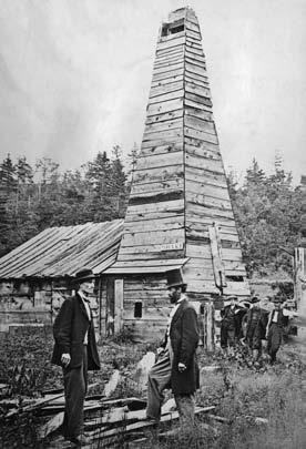
One of the earliest oil wells in the industry was in 1859 in Titusville, Pennsylvania (Figure 1). Edward L. Drake, a railway conductor with no technical background, found himself in charge of the operation. Drake studied the geology of the area and narrowed down the drilling location based on salt mining methods in the area. He formed a crew with some of the local salt miners and hired a blacksmith, who forged his own tools for the drilling. The derrick was made of pinewood, and a ram that was used to pound metal pipes into the ground was made of white oak. The ram was used in the initial drilling but when it could not penetrate the harder rock encountered at 12 m, the drilling continued with a steam engine. Closing into the reservoir, water began to flood the hole; Drake solved the problem by driving an iron pipe down to the bedrock then placed the drill inside the pipe to keep the water out of the excavated shaft. After five months, they were almost 21 m deep and they
finally struck oil. Drake’s drilling techniques and investigative methods would be used for other early wellsite operations, thus building the foundation for this industry.
Early prospectors used Drake’s methods and began drilling for oil elsewhere. They picked drilling locations based on nearby seeps, looked for oil residues in rock samples, and looked for gas leaks that could be ignited. Geologists and nongeologists continued to use and refine these methods, resulting in discoveries across Pennsylvanian and Appalachia.
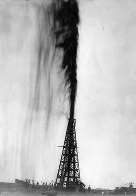
Wellsite geology moved into the modern oil industry at Spindletop, Texas in 1901 when Patillo Higgins, a self-educated geologist, investigated the hill in southeastern Texas (Figure 2). Previous wells in the area had encountered a zone that was impossible to drill through because of severe caving issues. Attempts at casing also met with failure because of the unconsoldated nature of the zone. Realizing that traditional drilling methods would not work, Higgins and his crew devised a method of suspending clay in water, which was then pumped down the hole. Not only did this ‘mud’ flush out the drill cuttings, the clay particles stuck to the sides of the hole, forming a thin, but strong sheath that stabilized the zone and kept it from caving in. This innovation led to the process of ‘Mud logging’ that is used today by wellsite geologists to determine
the position of hydrocarbons with respect to the depth and to identify downhole lithology.
MODERN W ELLSITE GEOLOG y
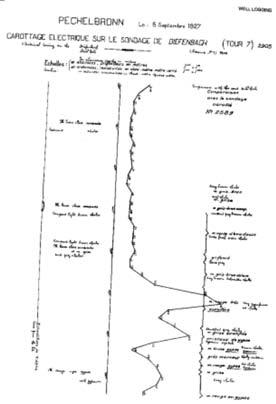
Wellsite geologists relied solely on drill cuttings and core samples to assess the hydrocarbon potential of wells prior to the 1930s, but this method was unreliable and frequently missed pay zones. The introduction of geophysical logs that showed electrical measurements taken in the boreholes helped identify geological formations around them (Figure 3). It gave wellsite geologists the ability to see what was down a well; it was also useful for comparing the neighboring wells and provided the ability to carry out precise correlation of formations across a field. By the 1970s, newer, more accurate logs were added to the resistivity logs. Further improvement came when the tools reading the electric, gamma ray, neutron, density, and caliper measurements were combined. The combination of the tools reduced operating time and improved accuracy of the data.
While early logs had to be hand delivered to the client, eventually, the data could also be delivered by phone and satellite. In 1977, trucks began to be equipped with computers that were able to upload to a central server. The logging techniques would
(Continued on page 22...)
RESERVOIR ISSUE 3 • MARCH 2013 21
Figure 1. Edwin Laurentine Drake well.
Figure 2. Oilwell gusher, Spindletop Field.
Figure 3. The first Schlumberger log for oil exploration in Canada was run in 1946.
(...Continued
go further with the development of tools that allowed directional measurements to be taken while drilling (MWD). By 1988, wellsite geologists were able to measure formation properties before drilling fluids influenced the data with the logging while drilling (LWD) tools (Figure 4).
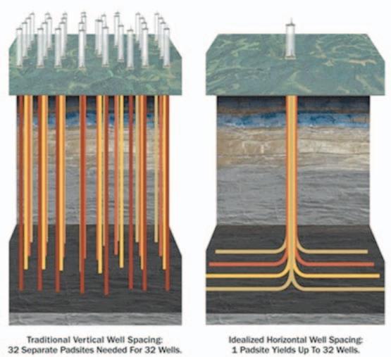
The increased use of horizontal wells since the 1980s has helped to make drilling much more efficient than vertical wells in draining reservoirs by greatly increasing the pay penetrated by the wellbore (Figure 5). Some of the first successful operations were in the North Dakota Bakken and the Texas Austin Chalk. These successes inspired a further testing of horizontal operations in a broad range of geographic regions and geological situations. As the technique became more common with operators, the length of the wellbore began to grow to lengths reaching 2,500 m. These early horizontals were effective, but it was still considered a last resort prior to the 1990s because of the cost and technical challenges. In recent years, the advent of unconventional plays and technological advancements has made horizontal drilling the new standard method in field development.
Wellsite geologists now have to supervise wells that are technically more difficult than conventional vertical wells. Using geosteering techniques, the geologist guides the horizontal well in order to optimize the pay and better develop the reservoir. Wellsite geologists use LWD and MWD to identify changes in rock type and quality, and to identify directional adjustments needed before the drillbit strays into non-reservoir rock or water zones.
Wellsite geology has grown from the domain of oilmen who used little geologic information to trained geologists using advanced tools and drilling methods to accurately assess a reservoir. The evolutionary process continues, and as the methods become more advanced, so will the technical skills of the wellsite geologist.

22 RESERVOIR ISSUE 3 • MARCH 2013
Figure 4. Logging while drilling example log.
from page 21)
Figure 5. Vertical vs. Horizontal wells.
UPCOMING EDUCATION SCHEDULE
Last Chance
Field Safety Course for Field Trip Leaders
March 27-28, 2013 Houston, TX
Deep-Water Siliciclastic Reservoirs
April 14-19, 2013 Northern California
Basic Well Log Analysis
Earlybird rates end March 15!
April 15-19, 2013 Austin, TX
Petrophysical Analysis and Integrated Approaches to the Study of Carbonate Reservoirs
Earlybird rates end March 18!
April 16-18, 2013 Austin, TX
Clastic Reservoir Facies and Sequence Stratigraphic Analysis of Alluvial-Plain,
Earlybird rates end March 18!
April 20-26, 2013 Shoreface, Deltaic, and Shelf Depositional Systems Utah
Short Courses
Basic Tools for Shale Exploration
Earlybird rates end March 22!
May 18, 2013 Pittsburgh, PA (with AAPG Annual Meeting)
Integrating Data to Evaluate Shale Resources
May 18-19, 2013 Pittsburgh, PA (with AAPG Annual Meeting)
Faults in the Northern Appalachian Basin and Their Effects on Black Shale
May 19, 2013 Pittsburgh, PA (with AAPG Annual Meeting)
Application of Organic Petrology for Shale Resource Evaluation
May 23, 2013 Pittsburgh, PA (with AAPG Annual Meeting)
Summer Education Conference – 11 courses over 5 days!
June 10-14, 2013 Fort Worth, TX
Short Courses
Field Seminars
Geology of Grand Canyon, Bryce Canyon and Zion National Park
June 1-7, 2013 Nevada
Play Concepts and Controls on Porosity in Carbonate Reservoir Analogs
June 2-7, 2013 Almeria, Spain
Folding, Thrusting & Syntectonic Sedimentation
June 3-7, 2013 Central Pyrenees, Spain
Lacustrine Basin Exploration
June 9-16, 2013 Utah
Registration and Information: Toll-free (U.S. and Canada) (888) 338.3387, or (918) 560.2650 • Fax: (918) 560.2678 • email: educate@aapg.org
a registration form at http://www.aapg.org/education/index.cfm
Download

GO TAKE A HIKE Horseshoe Canyon, Drumheller, Alberta
| By David A. Eberth
trailhead: Directly accessible by car; 15 km west of Drumheller, north side of Hwy 9; well signed.
Physiography and hiking: Horseshoe Canyon is mostly known as a section-scale (1 mi2; 2.5 km2) patch of badlands (dashed red box) adjacent to Highway 9, west of Drumheller. However the Canyon also includes a 6 km long, narrow and steep-sided coulee (HCC, red line) that drains into Kneehills Creek to the north. Maximum vertical relief in Horseshoe Canyon is 80 m. There are numerous tracks and game trails throughout the Canyon, but the open, three-dimensional nature of the badlands near the parking lot (green dot) allows hikers to explore the landscape in any direction they please. The landscape and distribution of modern plants and animals varies throughout the Canyon, reflecting profound year-round differences in runoff, erosion, sun/shade, wind, air temperature, and snow coverage.
The Nature Conservancy of Canada maintains a small group of trails and information signs along the Canyon’s western edge and within the Canyon. These are easily accessed a few hundred meters west of the primary parking lot. Secondary gravel roads access farms and well sites along either side of the canyon, and numerous pull-offs provide excellent vistas, but limited access to the Canyon.
During the busy summer months, Horseshoe Canyon is heavily visited by tourists on route to and from the Royal Tyrrell Museum and other sites in the Drumheller area. On any given day helicopter rides leave from the parking lot, and vendors are present selling fossils and snacks. The carnival atmosphere completely disappears by early Fall, however, making this the best time to explore the Canyon. At any time of year, only a few visitors venture beyond visual contact with the parking lot along the southern edge of the Canyon. Accordingly, the deeper parts of the Canyon, two or more kilometers to the north, are always great places for properlyequipped hikers to explore.
Irish (1970) applied the Horseshoe Canyon’s name to the drab colored, coal-rich bedrock strata exposed throughout the Red Deer River valley from Drumheller north to Big Valley. However, only the upper one-half of the Horseshoe Canyon Formation (HCF) is exposed throughout Horseshoe Canyon (Maastrichtian; 71-67 Ma). The coals visible in the Canyon at the parking area represent the Thompson coal zone. These appear to have formed in alluvial plain settings as opposed to the shoreline and lower coastal plain settings that host the stratigraphically lower coals throughout Drumheller. The contact between the Whitemud Member of the HCF and the overlying Battle Formation is present along the southern extent of the Canyon, adjacent to the parking lot. This contact is often draped and hidden by weathered and slumped mudstones, but is an
important surface, representing as much as 750,000 years of missing time.
Deeper into the Canyon to the north, one moves gradually lower in stratigraphic section. The noncoaly, green-grey Tolman Member that dominates these patchy exposures is rich in dinosaur bone fragments and represents a time of broad climatic cooling in southern Alberta. Farther down section, near the mouth of the Canyon at Kneehills Creek, exposures of the Drumheller Marine Tongue are plentiful and are dominated by storm generated coquinas of oysters and other marine pelecypods. With an age of ~ 70.6 Ma, the Drumheller Marine Tongue represents the last significant marine transgression in Western Canada and hosts the Campanian-Maastrichtian boundary.
r eference: Irish, E.J.W. 1970. The Edmonton Group of south-central Alberta. Bulletin of Canadian Petroleum Geology, v. 18, p. 125−155.
Satellite map from Google Earth
Paleontology: Identifiable fossils of early Maastrichtian dinosaurs were probably once plentiful at Horseshoe Canyon, but have been “picked clean” from the surface during the past 100 years. Although erosion continues to expose new material, it doesn’t happen fast enough to keep pace with fossil-souvenir hunters. In contrast, fossil charcoal, silicified tree stumps, coalified wood, and amber are common in the organic rich beds at Horseshoe Canyon. Likewise, pelecypods and trace fossils are common deeper in Horseshoe Canyon Coulee where they are found associated with iron-rich siltstones of the Drumheller Marine Tongue.
Background
by Astrid Arts.
Photo
24 RESERVOIR ISSUE 3 • MARCH 2013
Panorama of Horseshoe Canyon taken from the parking lot. Exposures represent the uppermost 50 m of the Horseshoe Canyon Formation (HCF) and the overlying Battle Formation (BF). Prominent dark bed is the #12 or Thompson coal. White horizon near the top of the section is the Whitemud Member (WM). Dashed line is the contact between the HCF and BF. Canyon continues north into the photo at top left (HCC).

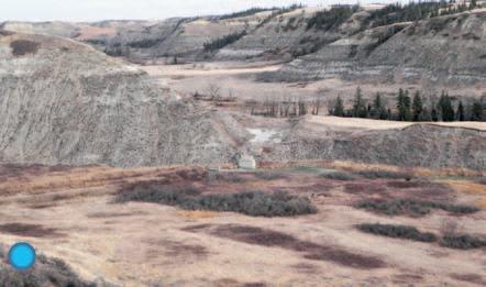
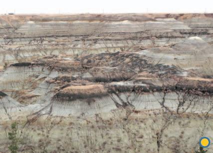
Grey sandstones represent deposits of high sinuosity paleochannels. Green-colored mudstones represent poorly-drained vertisols.

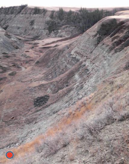 Horseshoe Canyon Coulee. Thompson coal
Kneehills “tuff” – a silicified paleosol.
Kneehills Creek occupies a kilometer-wide glacial valley.
Horseshoe Canyon Coulee is narrow and steep throughout its extent.
Horseshoe Canyon Coulee. Thompson coal
Kneehills “tuff” – a silicified paleosol.
Kneehills Creek occupies a kilometer-wide glacial valley.
Horseshoe Canyon Coulee is narrow and steep throughout its extent.
RESERVOIR ISSUE 3 • MARCH 2013 25
Fossil “hand” bones from the duck-billed dinosaur Hypacrosaurus in the Tolman Member of the Horseshoe Canyon Formation.
ROCK SHOP

油田投资项目咨询 油田收购评估 油气田勘探开发技术支持
Reservoir Geomodeling Reservoir Simulation Integrated Study
Julee Lee (403) 554-3957, Helen Cao (403) 968-6268, Gary Selby (403) 818-1594
jlee@petrosteer com, hcao@petrosteer com, gselby@petrosteer com


In-House and Multi-Media Narrated Self-Study Courses Also Available
Instructor: E. R. (Ross) Crain. P.Eng. 1-403-845-2527 ross@spec2000.net
Analysis, Training, Mentoring, Forensic Reviews

26 RESERVOIR ISSUE 3 • MARCH 2013 Strip Log Strip Log Horizontal Log Horizontal Log Mud Log Mud Log Log Viewer Log Viewer Log Manager Log Manager Log Analysis Log Analysis Suite 102, 7370 Sierra Morena Blvd SW, Calgary, AB T3H 4H9 info@WellSight.com 1-800-447-1534 (403) 237-9189
Excellence in Geological Services for Over 20 Years Integrated Reservoir Studies for All Resource Types 4D Geomodelling & Geosteering Horizontal Well Path Planning Infill Well Placement Studies SMART4D Modelling ® Software www.uogc.com 403.265.0111 91 0 , 396 11th Ave SW C a lgar y, AB Cana da WELLSITE GEOLOGICAL SUPERVISION Cell403 819 2516 farhat@sableconsultants.com SABLECONSULTANTS.COM Conventional Wells Coring Programs Heavy Oil/Oil Sands Coal Bed Methane SAGD Horizontal Project Supervision www.rpsgroup.com/energy (403)263-0449 17084 Global Leaders in Wellsite Geology Serving the petroleum industry for over 25 years ■■ Conventional Vertical / Horizontal Wells ■■ Unconventional Heavy Oil / CBM Wells ■■ International WSG / Operations Geology • Domestic and International wellsite supervision • Conventional and Unconventional wells • Extensive Hz experience • Customized corporate solutions available (403) 250-3982 sales@clconsultants.ca
For Engineers, Geologists, Geophysicists, and Technicians Practical Quantitative Log Analysis: 15 – 17 Apr 2013 Analysis of Unconventional Reservoirs: 18 Apr 2013 Analysis of Rock Mechanical Properties: 19 Apr 2013 Details and Registration at: www.spec2000.net/00-coursedates.htm
www.clconsultants.ca PRACTICAL LOG ANALYSIS COURSES
===
=== – 50 Years Worldwide
–
–
Experience
www.petrosteer.com 贝 特 斯 亚 海 外 石 油 研 究 中 心
49 TH A NNUAL W ESTERN I NTER-U NIVERSIT y Geoscience Conference (WIUGC)
| By Jonathan Marshall
January 3rd-5th marked the 49th annual Western Inter-University Geoscience Conference (WIUGC) hosted by the University of British Columbia’s G.M. Dawson Club in beautiful Vancouver, British Columbia. The event brought 83 geoscience students together for a three day student-run technical conference, providing geoscience students from all over Western Canada the opportunity to share ideas, presentations, and research. Universities represented at the conference included: the University of British Columbia, Simon Fraser University, the University of Calgary, the University of Regina, the University of Manitoba, and the University of Saskatchewan.
The conference began on a light note, commencing with the inaugural G.M. Dawson Club Dodgeball game. The game was followed by the Rio Tinto “Rock Breaker,” where students mingled with industry professionals while sharing in some easy-going geology trivia.
Day two began with a field trip to Britannia Mine, where those interested in the mining industry were able to tour the grounds and its associated water treatment facilities. The morning also gave students the opportunity to participate in a mineral deposits workshop hosted by Dr. James Scoates and Dr. Kenneth Hickey of UBC. The afternoon kicked-off with the WIUGC Industry Fair, allowing students to connect with various geological companies and organizations from all over Western Canada. The day concluded with a presentation from Jason Craven (Exploration Geologist for Cameco Exploration) on the “Real Geologists of the Saskatchewan Shore” and a presentation by Aaron Foyer (Geophysicist for Talisman Energy) on “Seismic Techniques in the Oil and Gas Industry.”
The last day of the conference consisted of eight student research presentations, (two graduate and six undergraduate) and several industry presentations. The CSPG Award for Best Petroleum-Related Presentation went to Samuel Snelling for his talk on “Reservoir Quality Analysis of the Middle Member of the McMurray Formation (Lower Cretaceous), Foster Creek Area, Northeastern Alberta.” The talk, which also won the “Best Undergraduate Thesis Presentation,” presents research Samuel
completed under the supervision of Dr. Nancy Chow, a sedimentology professor at the University of Manitoba. Other Notable presentations included Johan Gilchrist’s (University of British Columbia) talk on the “Origins of the Solar System: Osiris-Rex and Paleomagnetism,” which won the GSEG Award for Best Geophysical Presentation.
According to Nicole Marsh, president of the 2013 WIUGC Planning Committee, “the 49th Western Inter-University Geoscience Conference was a great success, owed inpart to the contribution and involvement of our supporters including Canadian Society of Petroleum Geologists.” She went on to express the students’ gratitude to
Leena Davis and Jonathan Marshall, the CSPG Outreach Committee members who attended the conference, for their active involvement in this year’s conference.
Overall, the 2013 WIUGC was an outstanding conference, providing a forum for both students and industry representatives to connect with young geoscientists. The CSPG is proud to sponsor the WIUGC, and we are looking forward to seeing you all in 2014.
RESERVOIR ISSUE 3 • MARCH 2013 27
Samuel Snelling (left) winner of the CSPG Prize for “Best Petroleum Related Talk” and the WIUGC Prize for “Best Undergraduate Thesis Presentation.”
PHOTO OF THE MONTH
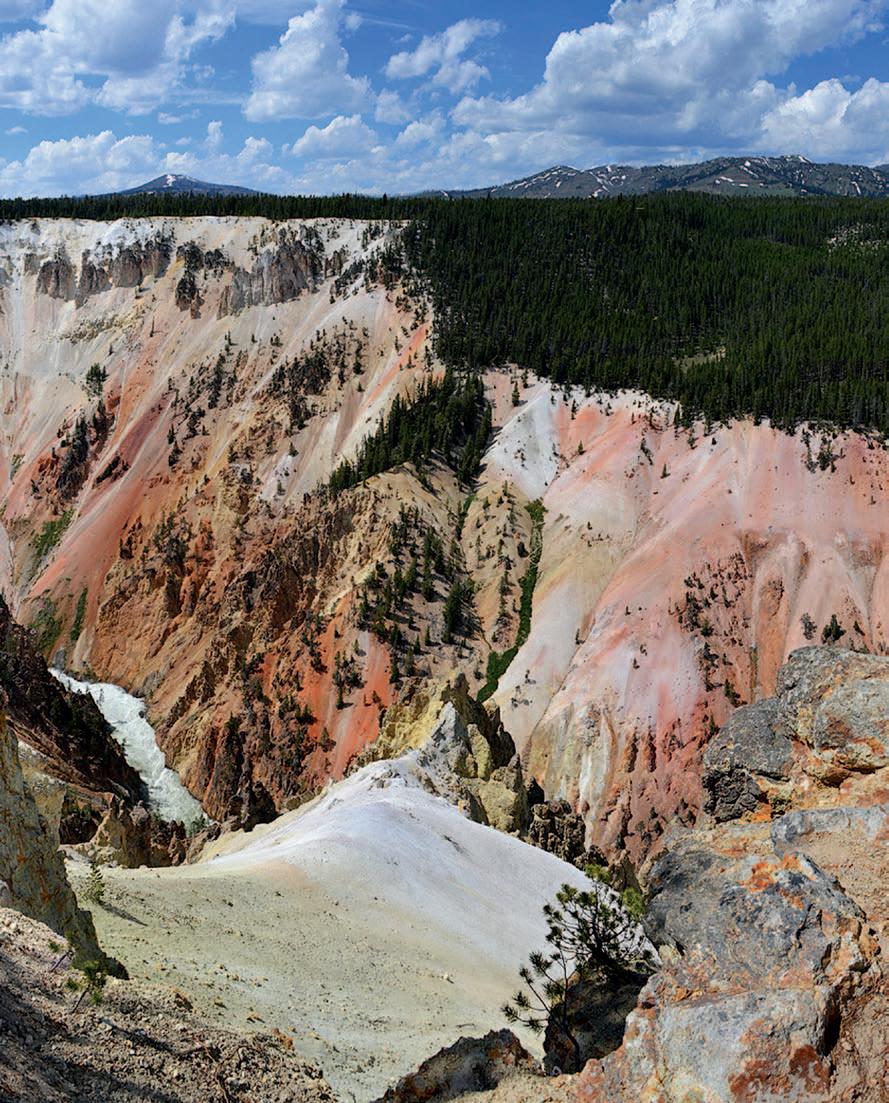
28 RESERVOIR ISSUE 3 • MARCH 2013
Grand Canyon of Yellowstone, WY. The canyon was thought to be originally formed by the erosion from glaciers approximately 10,000 years ago. The Yellowstone River now flows through the canyon, exposing hydrothermally altered volcanic ash and rhyolite. Photo by: Natalie Swanson.
2012 SLIPPER CITATION For Roger W. Smith
The Stanley Slipper Gold Medal is the C.S.P.G.’s most prestigious award. It was established in 1989 to honour individuals who have made outstanding contributions to the science of petroleum geology and to petroleum exploration in Canada. The award is named after Stanley E. Slipper, the founding President of the Alberta Society of Petroleum Geologists which we now know as the Canadian Society of Petroleum Geologists. Stanley Slipper is one of the iconic early explorationists in Western Canada.
Recipients of this award have made contributions encompassing one or more activities related to petroleum exploration and development. Such activities may include: initiating and leading exploration programs, teaching and mentoring, developing innovative exploration concepts, and including demonstrated leadership within geological societies and professional organizations.
The 2012 Stanley Slipper Gold Medal recipient is RoGER W. S mitH
STONECODE

Roger Smith was born on April 13, 1946 and grew up in Toronto. He was introduced to geology in his first year at Queen’s University, in Kingston, Ontario, by Dr. Jack Usher and his interest quickly developed into a passion for the science.
•Now offering a proprietary core index on-line via STONECODE HUB.
•Over 11,000 Carbonate and Clastic core interval descriptions in the WCSB available.
•If you cannot visit the core, the SCG interpretation can visit you, on your desktop.
•For a full listing of available core descriptions g o to www.scgltd.com and follow the links.

Stoakes Consulting Group Ltd
Suite 402, 103 - 10th Avenue NW, Calgary, AB, Canada T2M 0B4
Roger graduated from Queen’s with a B.Sc. (Eng.) in 1971 and in 1978 earned an M.Sc. (Marine Geology) from that same institution, under the mentorship of Dr. Grant Bartlett. He began his professional life as a marine geologist working and travelling throughout the world on a variety of oceanographic expeditions. In 1975, Roger decided to embark on a career in the Canadian petroleum industry, which he did by joining Shell Canada, there gaining an excellent foundation of technical and managerial skills. He initially worked as Manager of Biostratigraphy and the Geological Laboratory, a post that included work in support of Shell’s Frontier programs on the Scotian Shelf and in the Mackenzie Delta. He next worked as an exploration geologist, generating natural gas prospects in Alberta.
In 1979 Roger joined Canadian Hunter Exploration, led by John Masters and Jim Gray, as it was growing to exploit its industry-leading discoveries in the Deep
(Continued on page 30...)
ph: (403) 262-6003 fax: (403) 265-4662 email: stonecode.scg@shaw.ca
RESERVOIR ISSUE 3 • MARCH 2013 29
CORPORATE SUPPORTERS
AGAT Laboratories
Apoterra Seismic Processing Ltd.
ARC Resources Ltd.
Arcis Seismic Solutions
Cabra Consulting Ltd.
Canadian Natural Resources Ltd.
CGG Veritas Services Inc.
Compass Directional Services
Continental Laboratories Ltd.
Cossack Land Services Ltd.
Crescent Point Energy Trust
Datalog Technology Inc.
Edge Technologies Inc.
Encana Corporation
Exova Canada Inc.
Explor
GeoTir Inc.
GLJ Petroleum Consultants Ltd.
IHS
Kulczyk Oil Ventures
LXL Consulting Ltd.
McDaniel & Associates Consulting Ltd.
MOH & Associates Oilfield Consultants
National Oilwell Varco
Nickpoint Environmental Services
Olympic Seismic Ltd.
Paradigm Geophysical Corp.
Pason Systems Corp.
Perpetual Energy Inc.
Pioneer Professional Group
Pro Geo Consultants
ProActive Health
Pulse Seismic
Regent Resources Ltd.
Rigsat Communications
RPS Energy Canada Ltd.
SAExploration
Schlumberger Canada Limited
SeisWare
Sensor Geophysical Ltd.
Sigma Explorations Inc.
Sourcex
Total Gas Detection Ltd.
Trident Exploration Corp.
Western Geco
AS OF FEBRUARY 10, 2013
CSPG welcomes our 2013 Corporate Supporters!
The benefits of being a corporate member include:
• Recognition in the monthly Reservoir and quarterly Bulletin
• One associate membership
• Reserved tables at the technical luncheons with your company logo
• One free pass to the CSPG Core Conference
…and more! Contact Kasandra Klein at kasandra.klein@cspg.org to be a corporate member today!
Basin. As a development geologist, Roger conducted geological, petrological and petrophysical studies on CanHunter’s holdings in Wapiti, drilling numerous gas wells. He was strongly influenced by the company’s unique approach to exploration through the use of multidisciplinary teams and a dynamic, challenging and fun work environment. In 1982, he was transferred to Houston where he was Exploration Manager of a team charged with pursuing the prolific Austin Chalk oil play and finding another ‘Deep Basin.’ Upon returning to Canada in 1985, he became CanHunter’s Manager of Business Development, working with Steve Savidant. During that time, Roger completed the Stanford Executive Program.
In 1990, a new opportunity presented itself to Roger at Suncor Energy when he became Vice-President of Exploration with a mandate to revitalize the performance of Suncor’s exploration program. With the support of Barry Stewart and Rick George, Roger developed a strong team and exploration culture that within a couple of years began to achieve industry leading results in key metrics such as finding costs and reserve replacement ratios. This was accomplished through discoveries and production in the Triassic Montney turbidites (Manir, Valhalla, Knopick, Grand Prairie, Sinclair), the Mississippian Kiskatinaw (George), the Devonian Blueridge (Berland River), the Montney shoreface (Ante Creek) – plus others. During this time, Roger also led the expansion of Suncor’s exploration program into the USA and South America.
2000 brought a major change to Suncor that involved a higher level of commitment to the oil sands and reduced capital available for other operations. Rather than simply acquiescing to the significant reduction in exploration activity, Roger played a key role in convincing management to support a group of 12-18 people that came to be known as Prospect Generation Services (PGS). This organization, with Roger as its Vice-President, was both unique in North America and distinct from Suncor. Roger has characterized the team as technically strong, multidisciplinary, experienced and passionate about exploration – and the work environment as highly creative, energized and fun. The goal for PGS was to use this exploration and entrepreneurial expertise to create significant value, while investing minimal capital. The business model entailed generating and marketing drill-ready prospects/plays to the oil and gas industry in exchange for a deal structure whereby PGS shared both the exploration risk and development upside with its partners.
A typical deal involved PGS receiving compensation for its land investment, one or more drilling commitments, and a royalty on all PGS/Partner lands within the AMI. With success, PGS received royalty revenue on every producing well, or would occasionally negotiate the sale of these royalties for a lump sum payment up front. This concept succeeded by continuously rolling over the proceeds from royalties into the generation of new opportunities. Suncor was therefore able to reap the benefits of a creative and entrepreneurial staff while avoiding the demands for capital that would have accompanied drilling and infrastructure obligations. This way of approaching exploration – and being successful at it in a basin that many thought to be mature – is a tribute to Roger’s initiative, to his ability to build strong technical and business teams and to his determination to contribute through the application of exploration skills. The team over its life made over 400 technical presentations which led to $440 MM of industry investment, 192 wells drilled, 95 producing wells, and royalties on about 800 sections of land with an additional 400 sections of land acquired for the generation of new opportunities.
2009 brought another change of direction to Suncor through its merger with PetroCanada that resulted in the phasing out of the PGS team. In 2010, Roger became the President of Big Muddy Exploration Ltd., a private junior oil and gas company that is built on the same model as PGS, involves some of the same staff and generates opportunities in southern Saskatchewan.
Roger is currently a Board member on several Calgary-based petroleum and notfor-profit companies. He also is the Chair of the Queen’s University Geology Council.
Those of you who have met Roger will know that this citation would be incomplete without a mention of his infectious enthusiasm for all things with which he is involved. His positive attitude in both his industry and outside activities is an inspiration to those who work with him, as is demonstrated by his successful career. He has recently undertaken to synthesize his exploration experience and to present his ideas on the essential ingredients needed to achieve success in exploration to others.
Roger Smith is a very worthy recipient of the Stanley Slipper Gold Medal from several different perspectives. Congratulations.
30 RESERVOIR ISSUE 3 • MARCH 2013
page 29)
(...Continued from


ANNUAL GENERAL MEETING AND CONFERENCE April 18-20, 2013 Calgary TELUS Convention Centre Information: 780-426-3990 • 800-661-7020 | www.apega.ca
2013
APEGA SUMMIT
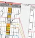
Blueback Reservoir the preferred and chosen GeoScience Solutions Partner Try something new. Find something better. Blueback Rock Physics plug-in for Petrel* Bridging the gap between geology and geophysics The complete suite of rock physics tools for quantitative interpretation across multiple domains within Petrel. Blueback Reservoir blueback-reservoir.com E sales@blueback-reservoir.com | T +1 403 538 4821 blueback-reservoir.com/rockphysics *Mark of Schlumberger 4000 5000 6000 8000 9000 10000 11000 12000 7000 13000 14000 15000 16000 Acoustic impedance (kP a.s/m) 17000 1.4 1.5 1.7 1.6 P/S velocity ratio 1.8 1.9 2.0 2.1 2.2 2.3 2.4 2.5 2.6 2.7 2.8 Por=0.4 Por=0.35 Por=0.3 Por=0.25 Por=0.2 Por=0.15 Por=0.1 Vol shl=0.6 Vol shl=0.4 Vol shl=0.2
Properties
Reservoir
Wells Petrel
