16 Horizontal Drilling in Western Canada – Part 2: The Evolution of Horizontal Drilling 21 2012 Andrew D. Baillie Awards 24 G o Take a Hike 28 F rom the Regulator’s Desk: Carbon Capture and Sequestration $10.00 NOVEMBER 2012 VOLUME 39, ISSUE 10 Canadian Publication Mail Contract – 40070050


> GEOSCIENCE SOFTWARE
> CRITICAL INFORMATION
> CONNECTED WORKFLOWS


CONNECTED AT EV ERY TOUCH P OI NT


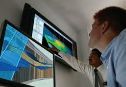
The IHS suite of geoscience software—which includes IHS Petra®, Kingdom®, LOGarc™ and GeoSyn™—is designed to seamlessly connect to the industry’s leading source of critical Oil & Gas information, eliminating the need to move data manually from source to source and project to project. With this powerful new combination, users can streamline data transfer, enhance database performance and simplify project sharing. The result? Workflows that connect like never before.
Connected workflows mean that IHS customers spend less time looking for data and more time looking for the next big opportunity. It’s just one of the many ways that IHS helps to advance the decisions that advance the Oil & Gas industry.
Find out more at IHS.com/geoscience

Streamline data transfer and simplify project sharing with IHS geoscience software and critical O&G information.
CSPG OFFICE
#110, 333 – 5th Avenue SW
Calgary, Alberta, Canada T2P 3B6
Tel: 403-264-5610
Web: www.cspg.org
Office hours: Monday to Friday, 8:30am to 4:00pm
Executive Director: Lis Bjeld
Tel: 403-513-1235, Email: lis.bjeld@cspg.org
Member Services:
Tel: 403-264-5610, Email: membership@cspg.org
Publications and Website: Emma MacPherson
Email: emma.macpherson@cspg.org, Tel: 403-513-1230
Programs Development: Aileen Lozie
Tel: 403-513-1227, Email: aileen.lozie@cspg.org
Database Administrator and Accounting: Kasandra Amaro
Tel: 403-513-1233, Email: kasandra.amaro@cspg.org
Corporate Sponsorship: Lis Bjeld
Tel: 403-513-1235, Email: lis.bjeld@cspg.org
Controller: Eric Tang
Tel: 403-513-1232, Email: eric.tang@cspg.org
EDITORS/AUTHORS
Please submit RESERVOIR articles to the CSPG office. Submission deadline is the 23rd day of the month, two months prior to issue date. (e.g., January 23 for the March issue).
To publish an article, the CSPG requires digital copies of the document. Text should be in Microsoft Word format and illustrations should be in TIFF format at 300 dpi., at final size. For additional information on manuscript preparation, refer to the Guidelines for Authors published in the CSPG Bulletin or contact the editor.
Technical Editors
Ben McKenzie Colin Yeo (Assistant Tech. Editor) Tarheel Exploration Encana Corporation
Tel: 403-277-4496 Tel: 403-645-7724
Email: bjmck@live.com Email: colin.yeo@encana.com
Coordinating Editor
Emma MacPherson, Publications Coordinator, CSPG Tel: 403-513-1230, emma.macpherson@cspg.org,
ADVERTISING
Advertising inquiries should be directed to Emma MacPherson, Tel: 403-513-1230 email: emma.macpherson@cspg.org. The deadline to reserve advertising space is the 23rd day of the month, two months prior to issue date.
available at the CSPG office. No official endorsement or sponsorship by the CSPG is implied for any advertisement, insert, or article that appears in the Reservoir unless otherwise noted. All submitted materials are reviewed by the editor. We reserve the right to edit all submissions, including letters to the Editor. Submissions must include your name, address, and membership number (if applicable). The material contained in this publication is intended for informational use only. While reasonable care has been taken, authors and the CSPG make no guarantees that any of the equations, schematics, or devices discussed will perform as expected or that they will give the desired results. Some information contained herein may be
RESERVOIR ISSUE 10 • NOVEMBER 2012 3 NOVEMBER 2012 – VOLUME 39, ISSUE 10 ARTICLES 2013 CSPG Geological Calendar 7 Horizontal Drilling in Western Canada – Part 2: The Evolution of Horizontal Drilling ........................................................... 16 2012 Andrew D. Baillie Awards 21 24th Annual CSPG/CSEG/CAPLA 10K & 5K Road Race and Fun Run ................ 22 Go Take a Hike ....................................................................................................................... 24 2011-2012 CSPG University Student Event Grant Winners ...................................... 26 Photo of the Month 27 From the Regulator’s Desk: Carbon Capture and Sequestration 28 DEPARTMENTS Executive Comment .......................................................................................................... 5 Technical Luncheons 9 Division Talks 13 Rock Shop ....................................................................................... 9, 10, 13, 15, 20, 21
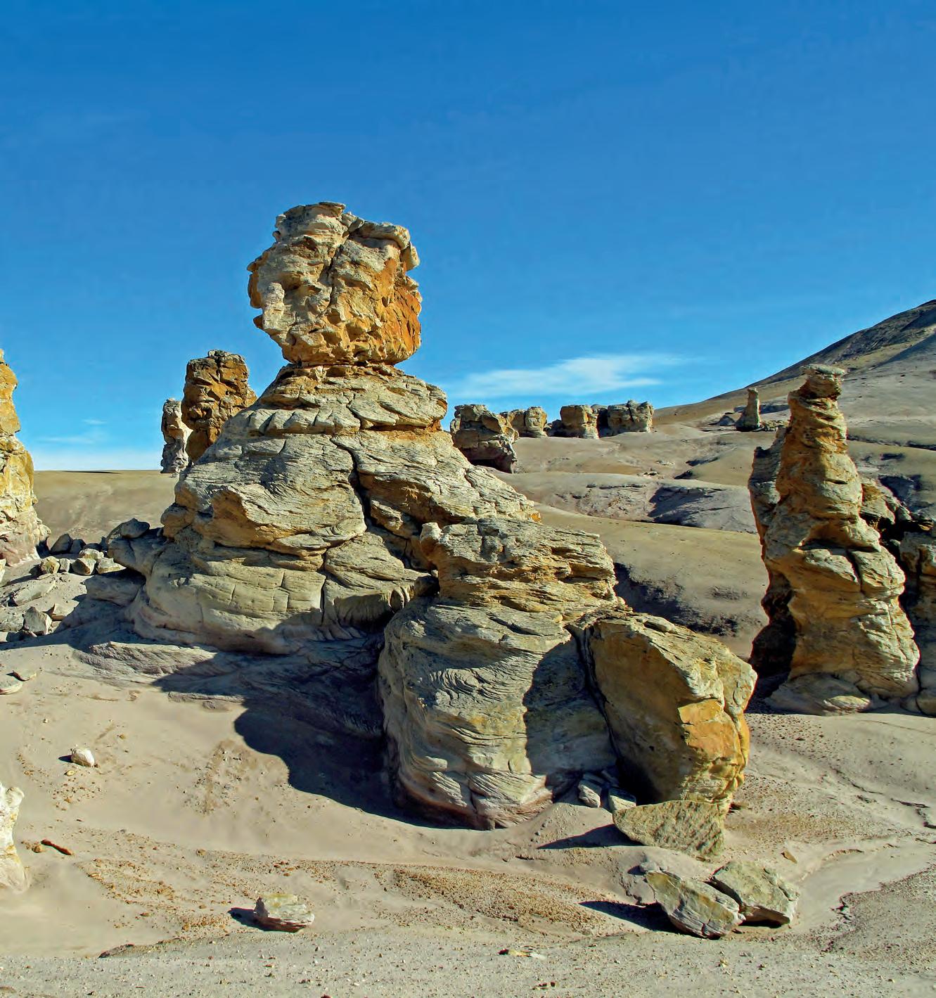
hoodoos on Ellef Ringnes Island, Nunavut in the High Arctic. This resistant sand unit is part of the Cretaceous Isachsen Formation, which was deposited primarily in a deltaic environment.
by Derrick Midwinter.
FRONT COVER Sandstone
Photo
guidelines can be found at http://www.cspg. org/publications/pubs-reservoir-submissions.cfm. The contents of this publication may not be reproduced either in part or in full without the consent of the publisher. Additional copies of the RESERVOIR are
liability
user
contained
this publication. Under no circumstances shall the CSPG
officers, directors, employees,
agents be liable
any injury, loss, damage,
expense arising in any manner whatsoever
the acts, omissions, or conduct of any third-party user. Designed and Printed by The Data Group of Companies, Calgary, Alberta.
The RESERVOIR is published 11 times per year by the Canadian Society of Petroleum Geologists. This includes a combined issue for the months of July and August. The purpose of the RESERVOIR is to publicize the Society’s many activities and to promote the geosciences. We look for both technical and non-technical material to publish. Additional information on the RESERVOIR’s submission
inaccurate or may vary from standard measurements. The CSPG expressly disclaims any and all
for the acts, omissions, or conduct of any third-party
of information
in
and its
and
for
or
from


They can copy us. They just can’t be us. If imitation is the sincerest form of flattery, we’re one flattered group. Drawing on a quarter century of oil and gas experience, geoLOGIC continues to be the market leader in data, software solutions and support. And while we lead the way, our competitors desperately create parity products, sometimes years after us. For details on how geoLOGIC leads the way, visit www.geoLOGIC.com/leader
Leading the way with customer-driven data, integrated software and services for your upstream decision-making needs.
geoSCOUT | gDC | petroCUBE at www.geoLOGIC.com


CSPG EXECUTIVE
President
Robin Mann • AJM Deloitte rcmann@deloitte.ca Tel: (403) 648-3210
Vice President
Paul MacKay • Shale Petroleum Ltd. Paul.Mackay@shalepetroleum.com Tel: (403) 457-3930
Past President
Kirk Osadetz • Geological Survey of Canada, Calgary kosadetz@nrcan.gc.ca Tel: (403) 292-7022
Finance director
Andrea Hood • geoLOGIC systems ltd. ahood@geologic.com Tel: (403) 262-1992
assistant Finance director
Samantha Etherington • CNRL samantha.etherington@cnrl.com Tel: (403) 386-6459
Program director
Jon Noad jonnoad@hotmail.com
assistant Program director
Dave Russum • AJM Deloitte drussum@deloitte.ca Tel: (403) 648-3228
serVices director
Michelle Hawke • Apache Canada Ltd. Michelle.Hawke@apachecorp.com Tel: (403) 261-1200
assistant serVices director
Mike Seifert • Canadian Discovery Ltd. mseifert@canadiandiscovery.com Tel: (403) 269-3644
communications director
Jim Barclay • ConocoPhillips Canada
Jim.E.Barclay@conocophillips.com Tel: (403) 532-3889
assistant communications director
Curtis Evans • ERCB curtis.evans@ercb.ca Tel: (403) 297-8386
outreach director
Simon Haynes • Statoil Canada Ltd. sihay@statoil.com Tel: (403) 724-0364
assistant outreach director
Dawn Hodgins • Imperial Oil Resources dawn.hodgins@exxonmobil.com Tel: (403) 232-5931
executiVe director
Lis Bjeld • CSPG lis.bjeld@cspg.org Tel: (403) 513-1235
EXECUTIVE COMMENT
A message from Mike Seifert, 2012 Assistant Services Director
As
I spent a few hours perusing some of the recent Executive Comments looking for inspiration for my own commentary ...
I was struck by the diversity of the individuals that serve on the CSPG Executive, and how that reflects in their Executive Commentaries. Obviously, the commentary reflects the author of the commentary and their role within the executive team; whether the theme centred around volunteerism, teamwork, or efforts to advance geoscience through the Outreach and Educational Trust Fund, they all have a primary goal: “…to promote and further the study of petroleum geology and its related sciences.”
I also browsed through the CSPG Website (www.cspg.org – just in case you haven’t been there for a while) for more inspiration and looked at the services that the CSPG offers to its members. The technical luncheons, conferences, publications, seminars, and field trips to promote the exchange of ideas, professional development, and lifelong learning; social events to help members get to know each other, share ideas and, in some cases, to develop lifelong friendships that transcend geology and work; the work of the Outreach Program and the Education Trust Fund help to attract young geologists and develop their careers, and to educate the public about the role that we as Petroleum Geologists play in society; and of course there is the Awards page on the website that allow us to recognise and acknowledge the members of our Society that have made significant contributions to the science of Geology and to the CSPG in so many different ways.
While Michelle Hawke (Services Director) and I spent some time pulling together the New Member Survey we discussed some of the responses from the 2009 survey, and how those responses have helped to determine what our members want from the CSPG, and what the Society needs to do in order to guide the long-term direction of the CSPG. Some of the discussion was around how do we ask questions that are meaningful, and will provide answers that reflect the wants and needs of our membership.
As I move from the role of Assistant Services Director to that of Services Director, I want to ensure that the CSPG continually understands the wants and needs of our members. This will enable us to provide the services needed for the Society and its members “to promote and further the study of petroleum geology and its related sciences,” and to have some fun, make new friends, and enjoy life along the way. Please take the time to fill out the survey and provide your input to help the CSPG better serve you.

Broaden your expertise.
NExT oil and gas training and career development instructs more than 10,000 E&P professionals every year.
With hands-on mentoring and coaching, at a Schlumberger training facility or on the job, NExT training can help you expand your technical expertise.
To view our full list of courses, and to enroll, visit www.NExTtraining.net
Featured course: Project Management 10–14 December 2012 Calgary, Alberta
RESERVOIR ISSUE 10 • NOVEMBER 2012 5
NExT is a mark of Schlumberger. Copyright © 2012 Schlumberger. All rights reserved. 12-DC-0077
Progress is in our genes
Meeting the world’s growing energy needs requires new ideas. That’s why we have built our Leismer demonstration project for Oil Sands in Alberta, Canada. At this cutting edge research facility, we are developing even better ways to increase heavy oil production and reduce the environmental footprint. And we keep improving, even when we reach our goals. We call it never being satisfied.
Learn more at neversatisfied.statoil.com Always evolving Never satisfied
CORPORATE SPONSORS
D IA mo ND
CENOVUS ENERGY
GEo LoG IC SYSTE m S LTD.
POGGENPOHL
PL ATIN um
IMPERIAL OIL LTD.
NEXEN INC.
SCHLUMBERGER CANADA LIMITED
SHELL CANADA LIMITED
Go LD APEGA
DEVON ENERGY CORP.
ENCANA CORPORATION
S I Lv E R
ATHABASCA OIL SANDS CORPORATION
CSEG FOUNDATION
CSPG ETF
ENERPLUS
IHS
JEWELSUITE
LED SIGNS
ROKE TECHNOLOGIES LTD.
RPS
SENSOR GEOPHYSICAL LTD.
TAQA NORTH LTD.
B Ro N z E
BLUEBACK RESERVOIR
EARTH SIGNAL PROCESSING LTD.
GEOSTRATA
GEOVARIANCES
GLJ PETROLEUM CONSULTANTS LTD.
HUSKY ENERGY INC.
PARADIGM
SUNCOR
TALISMAN ENERGY
TUCKER ENERGY SERVICES
AS OF OCTOBER 10, 2012
A SPECIAL THANKS TO GEOLOGIC SYSTEMS LTD., CSPG’S TOP SPONSOR OF THE MONTH
2013 CSPG GEOLOGICAL C AL ENDAR
| By Markus Ebner
In this Issue you will find the shiny new 2013 CSPG Geological Calendar – this annual favorite is sure to please with a wide diversity of geological wonders. We have been consistently receiving high-quality photographs from our members over the last number of years and this year has been no exception. Although initially we only had a trickle of photographs coming in, in the end we had 110 submissions – making the final selection of finalists difficult.
This year’s calendar is a carryover from last year’s 16-month format. We have decided to go back to a standard 12-month calendar and as such you will see there are no January and February 2014 photographs, while those for January and February 2013 were selected last year.
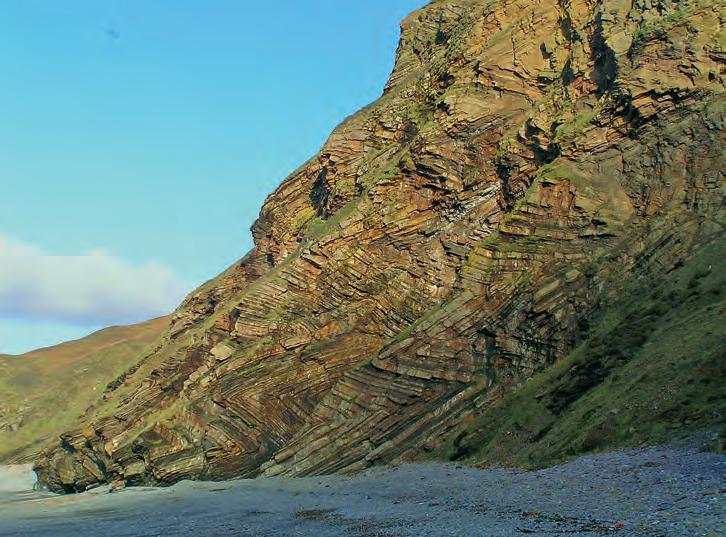
Some highlights from this year’s calendar include a spectacular shot of shrimp burrows of the genus Thalassinoides preserved in Miocene limestone beds by long-time contributor Jon Noad, who also coincidentally took the $200 for best photograph this year with his impressive shot of highly folded, interbedded sandstones and shales of the Crackington Formation near Bude, Cornwall. Annual contributors Rhea Karvonen and Peggy
Hodgkins gave us the delights of White Sands National Monument, New Mexico and (keeping it close to home) Hector Lake, Banff National Park, Alberta, respectively. Never one to disappoint, Mike Lam, our calendar Best Photo winner the previous two years running, submitted a very artistic shot of Mt. Fuji, Honshu, Japan.
We have made an attempt to select photographs showing a wide diversity of local and international geology while trying to encompass many different types of rock phenomena. Unfortunately this year, the call for sub-category of Best Bedform Photograph was not filled by a winner that made it through the selection process.
I would like to thank my partners in this project, Emma MacPherson, our Publications Coordinator and Donna Elkow-Nash, our calendar graphic designer. Additionally, I would like to thank the troupe of Judges that assembled and helped to rank all of the submitted photographs: Hailey Doney, Erik Parker, Mark Taylor, and Darin McBeath.
I hope that the 2013 CSPG Geological Calendar adds some extra geological ‘flair’ to your office space over the coming year.
RESERVOIR ISSUE 10 • NOVEMBER 2012 7
Thinly interbedded sandstones and shales of the Crackington Formation deposited in a warm, Carboniferous Lake in Millook Haven, near Bude, Cornwall. The sediments were later dramatically folded in the Variscan orogeny. These folds are sometimes known as zigzag folds. Cliff is approximately 50 meters in height. Photo by Jon Noad.
All ages welcome
Adults: $20 ($25 at door) students: $10 ($15 at door) Children (12 & under): free For groups of 10 or more please contact the CSPG office at (403) 264-5610 | www.cspg.org
From Evolution to Exploration
Our African Journey
2012 HONORARY ADDRESS
Monday Nov. 26 2012
Southern Alberta Jubilee Auditorium, Calgary AB Doors 6:00 pm | Talks 7:00 pm
SPEAKERS
Ian Tattersall – Curator Emeritus, Biological Anthropology American Museum of Natural History, New York Dr. Trent Rehill – VP Geosciences, Kulczyk Oil Ventures
technicaL Luncheons NOVEMBER LUNCHEON
Carbonates –A challenge for basin modelers
SPEAKER
marek Kacewicz
AAPG Distinguished Lecture
11:30 am
tuesday, november 13, 2012
teLus convention centre
calgary, alberta
Please note: the cut-off date for ticket sales is 1:00 pm, thursday, november 8th, 2012. csPg member ticket Price: $42.00 + gst. non-member ticket Price: $45.00 + gst.
Each CSPG Technical Luncheon is 1 APEGA PDH credit. Tickets may be purchased online at www. cspg.org.
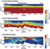
Our understanding of facies and internal connectivity within carbonate platforms is often inadequate despite the fact that carbonate petroleum systems are widespread throughout the world, account for approximately 50% of world hydrocarbon reserves, and have been heavily studied for many years. Petroleum systems modeling routinely used in exploration allows testing different facies distribution / connectivity scenarios and contributes to a better understanding of key uncertainties and reduction of exploration risk. However, if misused or based on insufficient input data, petroleum systems models may generate
ROCK SHOP
misleading results and lead to drilling unnecessary dry holes. This is especially true if the resolution of the model is too low or calibration data is sparse.
Regional-scale petroleum systems models of carbonates often miss the critical details such as platform geometry, facies distribution within a platform, and highresolution rock flow/seal properties that are required for a proper evaluation of hydrocarbon migration, prediction of pre-drill pressure, and estimation of accumulated hydrocarbons. In addition, they typically don’t address syn- and postdepositional factors such as diagenesis and stress history.
For the purpose of this study, a synthetic carbonate platform was built to demonstrate typical problems associated with modeling carbonate petroleum systems and for testing potential hydrocarbon migration and trapping scenarios. It allows simulating petroleum systems that are similar to the Arab and Khuff formations in the Middle East, isolated platforms in Kazakhstan, and others. This presentation will discuss petroleum systems modeling methodology and guide the audience through different low- vs. high-resolution scenarios leading to dramatically different exploration implications.
B IO GRAPH y
M arek Kacewicz is research consultant and basin modeler at Chevron Energy Technology Company in Houston, Texas. His primary responsibilities include research and technology applications integrating petroleum


Webcasts

systems modeling, seismic inversion, velocity modeling, pressure prediction, geomechanics, and structural modeling.
Prior to Chevron, Marek worked as a research geologist at ARCO Exploration and Production Research Center in Plano (Texas, USA), as a basin modeler at Unocal Exploration & Exploitation Technology in Sugar Land in Houston (Texas, USA), Alexander von Humboldt Fellow at the Freie Universitaet Berlin (Berlin, Germany), and Research Assistant at the University of Warsaw (Warsaw, Poland). Marek has over 20 years of experience in petroleum systems modeling, exploration, and research.
His experience includes both conventional and unconventional resources and covers a wide range of sedimentary basins worldwide. Some of Marek’s professional honors include receiving the 1986 International Association for Mathematical Geology Vistelius Research Award, being selected for the Alexander von Humboldt Fellowship (Germany), and receiving the 2005 AAPG Gabriel Dengo Memorial award.
Kacewicz has an M.S. degree in Numerical Mathematics / Computer Science and a Ph.D. in Earth Sciences, both from the University of Warsaw (Poland).
This talk is funded by the AAPG Foundation J. Ben Carsey Endowment.


• Domestic and International wellsite supervision • Conventional and Unconventional wells • Extensive Hz experience • Customized corporate solutions available (403) 250-3982 sales@clconsultants.ca www.clconsultants.ca CD N BA CD BA n yevr us 234 765 101112 15 8 9 16 1413 23456 11 10987 1716151413 2322212019 2627282930 35 12 18 24 25 36 34333231 section lsd township
sponsored by
Conventional Vertical and Horizontal Wells Oil Sands - SAGD/Coring Programs Shale Gas/Oil Shales Coal Bed Methane Project Supervision Email: progeo@telus.net Tel: (403) 262-9229 Fax: (403) 265-0377 Website: www.progeoconsultants.com petrographical & sedimentological descriptions for samples (thin section - fluid inclusion studies) conventional vertical/horizontal wells operations geology SPECIALIZED IN GEOLOGICAL WELLSITE SUPERVISION AND CORE ANALYSIS RockWell Consulting our best friend and most valuable partner is our client Stephan C. Dragomir president www .g e ok2. c om - phon e: 403.831.9941 - s dr a gomir @ge ok2. com
technicaL Luncheons NOVEMBER LUNCHEON
What petroleum geologists can learn in Vancouver: Lessons from the Fraser River, B.C.
SPEAKER
Shahin E. Dashtgard Applied Research in Ichnology and Sedimentology (ARISE) Group, Department of Earth Sciences, Simon Fraser University
11:30 am tu esday, n ovember 22, 2012 te Lu s convention centre c algary, a l berta
Please note: the cut-off date for ticket sales is 1:00 pm, thursday, november 16, 2012. csPg member ticket Price: $42.00 + gst. non-member ticket Price: $45.00 + gst
Each CSPG Technical Luncheon is 1 APEGA PDH credit. Tickets may be purchased online at www.cspg.org.
A B STRACT
The economic success of steam-assisted gravity drainage is largely dependent on the geometries of mud beds and muddy bedsets in bitumen-saturated sandstone reservoirs. Inclined mud beds interbedded with sand act to block steam flow through
ROCK SHOP
the reservoir resulting in bypassed pay and poor recovery. To better understand how mud beds are distributed in the reservoir, modern analogs are being studied, including the Fraser River, B.C.
In the lower reaches of the Fraser River, inclined heterolithic stratification (inclined interbeds of sand and mud; IHS) is developed and distributed on bars through the tidal-fluvial transition. In terms of IHS character, the tidal-fluvial transition of the lower Fraser River can be grouped into three distinctive regions: subequal tidal-fluvial; tide-influenced, fluvially dominated (brackish water); and, tideinfluenced, fluvially dominated (freshwater only). Where the water is always fresh, mud is rarely deposited and IHS is not developed. Where brackish water persists in the channel, increasing fluvial influence is manifested by a decrease in bedding rhythmicity, and an increase in the variability of sand and mud bed thicknesses. The lateral continuity of muddy bedsets is maintained where brackish water persists, and rapidly decreases with the absence of brackish water. Ichnologically, subequal tidal-fluvial stretches of the Fraser are characterized by a low- to moderate-diversity suite of small and large vertical traces. The diversity and size of burrows decreases with decreasing tidal and especially brackish-water influence, and the freshwater-influenced region exhibits very rare to no burrowing.
The relative dominance of tidal and fluvial flow in the Fraser determines the sedimentological, ichnological, and architectural character of the IHS. By reversing this logic, the sedimentology and


Webcasts sponsored by
ichnology of IHS in the rock record can be used to predict the dominant depositional processes by which it was deposited. Perhaps more importantly, and with additional research on modern analogs, it should be possible to predict the geometries of muddy bedsets in IHS based on the character of the sediments.
BIOGRAPH y
Dr. Dashtgard earned his B.Sc. degree in Geology in 1998 from the University of Alberta. For four years following his graduation, he worked in the oil and gas industry, first for Fletcher Challenge Energy Canada, and then Talisman Energy.
In 2002 Shahin started his Ph.D., which focussed on gravel-dominated deltas and tidal shorefaces in the Bay of Fundy, Canada. He finished his Ph.D. at the University of Alberta in 2006, and worked for eight months with the Alberta Geological Survey doing reservoir modelling of the Cardium Formation for the purpose of CO2 -enhanced oil recovery and sequestration. In 2007, Shahin started as an assistant professor at Simon Fraser University and is now an associate professor in the same department. In May 2012, Shahin received the James Lee Wilson Award, which is awarded by the SEPM for “excellence in sedimentary geology by a young scientist.”
For the past five years, Shahin’s research interests have mainly focused on the Fraser Delta, on modern and ancient shoreface deposits, and on process ichnology.
10 RESERVOIR ISSUE 10 • NOVEMBER 2012
1602 – 5th St N.E. Calgary, AB T2E 7W3 Phone: 403-233-7729 www.tihconsulting.com e-mail: tih@shaw.ca T.I.H. Consulting Ltd. Geologic Well-Site Supervision
technicaL Luncheons DECEMBER
Beyond Roads –The Musandam Expedition
SPEAKER
Dr. Simon Donato
11:30 am
tu esday, d e cember 11, 2012
t e L u s c onvention c en tre c al gary, a l berta
Please note: the cut-off date for ticket sales is 1:00 pm, thursday, december 6, 2012. csPg member ticket Price: $42.00 + gst. non-member ticket Price: $45.00 + gst.
Each CSPG Technical Luncheon is 1 APEGA PDH credit. Tickets may be purchased online at www.cspg.org.
A B STRACT
I solated. Rugged. Desolate and beautiful, the Sultanate of Oman is a desert nation containing vast ergs, rugged coastline,
and a mountainous hinterland. It is also a country with a rich cultural record, rooted in antiquity. Although well known for its ophiolites and hydrocarbon deposits, Oman is uniquely situated near the Makran subduction zone. Its coastal embayments have the proven ability to preserve tsunami deposits (tsunamites), which are useful for constructing tsunami periodicity, as well as recording seismicity along the Makran subduction zone.
The Beyond Roads expedition was the first scientific expedition to explore the Musandam Peninsula north of Khasab, Oman. A team of three Adventure Scientists became the first Westerners to survey the mountainous interior of this region in well over 50 years. This area has remained unstudied due to the complete absence of roads, lack of fresh water, and the steepness of the terrain. The goals of the expedition were to conduct a preliminary sedimentologic expedition in several east-facing embayments to test for the presence of tsunamites, and to explore the hinterland for undescribed archaeological sites. This talk will provide
a humorous and insightful look at the man-made and natural obstacles the team faced during their expedition, as well as present the exciting findings from this 10-day experience.
B IO GRAPH y
D r. Simon Donato is the founder of Adventure Science and lives in Calgary. A McMaster University graduate, he spent over four years working as a stratigrapher for a large Calgarybased oil and gas company. Driven by his love of exploration, he has recently taken his geoscience career in a new direction, leaving his desk job to become the host for an new adventure travel television show called Boundless, set to air during winter, 2013. More information on Adventure Science can be found on www.adventurescience.ca.
RESERVOIR ISSUE 10 • NOVEMBER 2012 11
LUNCHEON Webcasts sponsored by CSPG CONTINUING EDUCATION CONTINUING EDUCATION 2013 Training Program www.cspg.org/CSPG/Education GeoConvention Spring Courses Mid April - Mid May 2013 Summer Field Seminars July - September 2013 Fall Education Week October 2013 ONLINE REGISTRATION OPENS DECEMBER 1, 2012! CHECK THE CSPG WEBSITE FOR MORE INFORMATION CONTINUING EDUCATION 2013 Training Program www.cspg.org/CSPG/Education GeoConvention Spring Courses Mid April - Mid May 2013 Summer Field Seminars July - September 2013 Fall Education Week October 2013 ONLINE REGISTRATION OPENS DECEMBER 1, 2012! CHECK THE CSPG WEBSITE FOR MORE INFORMATION CONTINUING EDUCATION 2013 Training Program www.cspg.org/CSPG/Education GeoConvention Spring Courses Mid April - Mid May 2013 Summer Field Seminars July - September 2013 Fall Education Week October 2013 ONLINE REGISTRATION OPENS DECEMBER 1, 2012! CHECK THE CSPG WEBSITE FOR MORE INFORMATION
PETROLEUM INDUSTRY COURSES
OVERVIEW OF THE OIL & GAS INDUSTRY IN WESTERN CANADA
Date: November 28th and 29th, 2012
Cost: $945 (includes GST)
Instructor: Bill Ayrton
Effective for personnel just joining the oil patch, or for financial, accounting, and information systems personnel.
• Learn about the many facets of the industry.
• Oil finding, land acquisition, drilling, seismic, well completion, jargon and terminology.
GEOLOGY FOR NON-GEOLOGISTS
Date: December 11th and 12th, 2012
Cost: $945 (includes GST)
Instructor: Bill Ayrton
Effective for geological technicians or administrative staff, or for those who just want a better understanding of geology to appreciate the world around us.
WHO SHOULD ATTEND
New geologists, engineers, geophysicists and landmen, as well as summer students entering the industr y for the first time will find the courses a very beneficial introduction to the petroleu m industry These courses will be extremely useful to nonprofessional and support staff in the oil and gas industry, as w ell as accountants, lawyers, brokerage and financial personnel working primarily alongside the oil and gas industry.
TO REGISTER
To register or to obtain additional information regarding in-house and upcoming courses, please contact:
Ayrton Exploration Consulting Ltd.
Tel: (403) 262-5440
Email: ayrtonex@shaw.c a
Or visit our website: www.ayrtonexploration.com
• Learn about earth structure, geologic time-scale and processes, Western Canada geology, and interesting nearby locations.
• Participate in a r ock identification exercise , cross-section project and a mini-field trip in downtown Calgary.
GEOLOGY OF THE WESTERN CANADIAN SEDIMENTARY BASIN
Date: October 30th, 31st, and November 1st, 2012
Cost: $1365 (includes GST)
Instructor: Bill Ayrton
Ideal for those who wish to improve their geological understanding of where and how we look for oil and gas fields in Western Canada.
• To visualize what Western Canada looked like throughout the stages of history, for example, the position of the sea versus land, what sediments were deposited, and what type of life that existed and evolved.
• To review the importance of each major stratigraphic unit, i.e. Devonian, Mississippian, Cretaceous, etc.
• Discuss the geological and seismic expression of typical oil and gas fields in each unit.

12 RESERVOIR ISSUE 10 • NOVEMBER 2012
technology • seismic • rocks • maps • formations • land • sediments • history • sea • fossils • environment
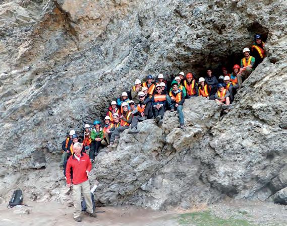
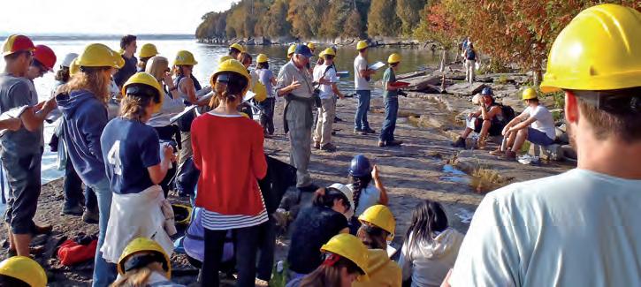
CSPG Student Industry Field Trip
Photo by: Bill Ayrton
GE OLOG Y FO R NON- GE OLOG ISTS Pr ted by W.G. ( Bi ll) A yr to n
diVision taLKs BASS DIVISION
The Peace River Formation: Controls on sedimentation
SPEAKER
Robin Buckley
Husky Energy
12:00 Noon
Friday, November 9th, 2012
ConocoPhillips Auditorium, Gulf Canada Square, 401 – 9th Ave. S.W. Calgary, Alberta
The Middle to Upper Albian Peace River Formation was deposited in the Western Canada Foreland Basin and consists of three members: the Harmon Member is a broadly transgressive marine mudstone that is overlain by broadly regressive shoreface sandstones of the Cadotte Member. Sandstones of the Cadotte are capped by a subaerial unconformity that defines the base of the Paddy Member.
The basis for this talk is an M.Sc. thesis completed in 2011 under the supervision of Dr. Guy Plint. The thesis is a regional study based on detailed correlation of 17 allomembers using over 800 geophysical well logs, 15 outcrop sections, and 21 cores covering an area of over 38,000 square kilometres.
Changing patterns and rates of flexural
subsidence during deposition of the Peace River Formation are indicated by progressive changes in stratal geometry within depocentres, and by spatial changes in depocentre location and orientation. Flexural subsidence during deposition of the Harmon Member resulted in a wedgeshaped body of rock that thins over 250 km from 108 m in the foredeep to 2 m near the forebulge. In contrast, the Cadotte Member has a relatively tabular geometry, thinning from 58 to 13 m from SW to NE, and was deposited during a phase of minimal differential subsidence, possibly related to limited thrust activity, and/or erosional unloading in the adjacent sector of the fold and thrust belt. Lower Paddy allomembers are wedge-shaped and imply deposition during a time of more rapid flexural subsidence; in contrast, upper Paddy allomembers are much more tabular, suggesting deposition during another phase of relative tectonic quiescence.
High-frequency (~100 ky) sea-level fluctuations, indicated by regionally mappable flooding surfaces, provided accommodation for a succession of at least three stacked, progradational shoreface sandstones within the Cadotte Member. These sea-level changes, probably attributable to eustasy, also resulted in stacked shallow marine and lagoonal sequences in the Paddy Member.
The Cadotte and most of the Paddy are composed of chert-rich lithic arenite of Cordilleran provenance. In the eastern part of the basin however, parts of the Paddy consist of essentially chert-free
quartz arenite, typically comprising very well-rounded quartz sand. It seems likely that the quartz arenites were derived from erosion of Lower Cretaceous strata in eastern Alberta, that ultimately were of cratonic provenance. Erosion in the east may indicate forebulge uplift, dynamically linked to a phase of flexural subsidence in the west that generated accommodation for the entire Paddy wedge.
B IO GRAPH y
R obin Buckley is currently a geologist at Husky Energy. Robin graduated from the University of Western Ontario in 2011 with her M.Sc. in geology and completed her B.Sc. at Dalhousie University in 2009.
I N FORMATION
B ASS Division talks are free. Please bring your lunch. For further information about the division, joining our mailing list, a list of upcoming talks, or if you wish to present a talk or lead a field trip, please contact either Steve Donaldson at 403-766-5534, email: Steve.Donaldson@cenovus.com or Mark Caplan at 403-817-2603, email: mcaplan@ atha.com or visit our web page on the CSPG website at http://www.cspg.org.

Reservoir Geomodeling Reservoir Simulation Integrated Study
Julee Lee (403) 554-3957 Helen Cao (403) 968-6268 Gary Selby (403) 818-1594 jlee@petrosteer com, hcao@petrosteer com, gselby@petrosteer com
Geology, and Geophysics Computer-Ready Math, 350 Topics, 2000 Illustrations, Case Histories, Clear, Simple, No-Nonsense Explanations, Spreadsheet Software
=== Order CD-ROM On-Line at: www.spec2000.net/00-orders.htm
=== In-House and Multi-Media Narrated Self-Study Courses Also Available E. R. (Ross) Crain. P.Eng. Phone: 1-403-845-2527 Email: ross@spec2000.net
-– 50 Years Worldwide Experience – Training – Mentoring – Forensic Reviews –
RESERVOIR ISSUE 10 • NOVEMBER 2012 13
Sponsored by ROCK SHOP HANDBOOK PETROPHYSICAL S C Version2.13 Edition– Millenium 3rd ==== Integrated Petrophysics for Engineering,
===
=== 油田投资项目咨询 油田收购评估 油气田勘探开发技术支持
www.petrosteer.com 贝 特 斯 亚 海 外 石 油 研 究 中 心
diVision taLKs PALEONTOLOGY DIVISION
Dragon Tails: An asiatic dinosaur expedition and
study of
the
convergent evolution of winged archosaurs
SPEAKER
W. Scott Persons, I v
7 :30 Pm
a
Friday, November 16th, 2012 m ount Royal u niversity, Room B108 Calgary, Alberta
A B STRACT
“ Dragon Tails: An Asiatic Dinosaur Expedition and a Study of the Convergent
Evolution of Winged Archosaurs” is a combination travel slideshow and scientific presentation. In the summer of 2010, Scott Persons traveled to South Korea, China, and Mongolia. This talk covers a joint Canada, Korea, China, and Mongolia expedition into the Gobi Desert where the expedition found dinosaur eggs, footprints, and the fossil skeletons of tyrannosaurs, oviraptorosaurs, ornithomimids, and titanosaurs. Three weeks were spent photographing and measuring some of China’s famous feathered dinosaur museum specimens. Scott also devoted time to his personal research, studying the similarities between the tails of dromaeosaurid (raptor dinosaurs) and primitive pterosaurs (flying reptiles).
B IO GRAPH y
S cott Persons is originally from North Carolina and completed an undergraduate degree at Macalester College in St. Paul, Minnesota. He completed his Master’s degree at the University of Alberta where he is presently working on his Ph.D. program focusing on the tail anatomy of non-avian theropod dinosaurs, which includes the big carnivores
like Tyrannosaurus and Albertosaurus. Some dinosaur tail muscles were connected to their leg bones as well as to their hips, so his work has direct implications for assessments of dinosaur speed. Scott is also concerned with charting evolutionary trends in tail morphology across the theropod lineage and with the specialization of different tail forms in different theropod groups.
I N FORMATION
T his event is jointly presented by the Alberta Palaeontological Society, Mount Royal University, the CSPG Palaeontology Division, and Cenovus Energy. For details or to present a talk in the future please contact CSPG Paleo Division Chair Philip Benham at 403-6913343 or APS Coordinator Harold Whittaker at 403-286-0349 or contact programs at www.albertapaleo.org. Visit the APS website for confirmation of event times and upcoming speakers: http://www.albertapaleo.org/.


14 RESERVOIR ISSUE 10 • NOVEMBER 2012
by Canadian Discovery Ltd. Hydrodynamics Source Rock Evaluation Reservoir Characterization Stress Analysis Quantitative Seismic Interpretation Geomechanics Well Location Discover how our combined expertise of geology, geophysics and geomechanics enables you to move through the cycles from exploration to appraisal to development faster and with an increased probability of success. Maximize your opportunities; book a meeting with us today. T 403.269.3644 | www.canadiandiscovery.com Canadian Discovery and Sound QI join forces to offer fully-integrated solutions for subsurface characterization. Advisors to the Resource Sector... Leading with Ideas!
Sponsored
diVision taLKs GEOMODELLING DIVISION
On improving by-facies geomodeling
SPEAKER
o lena Babak
Total E&P Canada Ltd.
12:00 Noon
Wednesday, November 28, 2012
Locaton TBA – Check Website
Geological modeling in mining and petroleum applications often involves the process of upscaling from the available sample data to a geological modeling grid cell or flow-simulation grid cell scale. Sample data are typically full core or core-plug data and have a scale in the centimeter range. Geological models are usually designed at a larger scale resulting in grids with a manageable number of cells and a reasonable representation of the underlying geology.
Upscaling leads to an inevitable loss of information and the degree of loss is related to the type of variable and characteristics of its spatial distribution. For example, a continuous property such as porosity may yield a very small loss due to upscaling when it is smoothly varying throughout a reservoir. In another scenario, another variable such as bitumen grade may vary erratically due to the underlying distribution of lithology and there is potential to smooth out small high-grade intervals during the upscaling
ROCK SHOP
process. The loss of information due to upscaling categorical variables can also be significant. Facies can be layered in intervals having a thickness that is less than the geological grid cell size.
More information can be retained during facies upscaling. Rather than excluding all but the majority, the proportions of each facies within a grid cell could be retained. However, existing workflows and modeling algorithms for building geological models are not suited to proportions. A simpler approach and the focus of my talk is to account for the fact that multiple facies exist within a grid cell while maintaining the use of majority upscaling and categorical models. An advantage is that facies can still be modeled using any approach such as sequential indicator simulation or multiple point statistics.
A measure of the uncertainty associated with the majority facies from upscaling is retained. The measure used is conditional entropy calculated from the proportions of facies, conditional to the majority facies. Uncertainty is related to the degree of mixing of different facies within a grid cell. When there is an equal proportion of all facies involved, the entropy is maximized, while when only one facies is present, the entropy is zero. The entropy measure is also flexible in that any similarity between different facies types can be accounted for. For example, in a three-facies system involving sand, shale, and mixed sand and shale, the similarity between sand and mixed and shale and mixed can be used.
Incorporating the entropy measure into
Sponsored by
existing geological modeling workflows is straightforward and is illustrated by a small example. To further understand the statistical behaviour of entropy, effects of scale on entropy are studied including changes in the histogram, variogram, and correlation coefficients with other variables. A comparison of estimation accuracy with and without entropy using a jackknife study is provided using real data in the McMurray Formation from Total’s Joslyn lease.
B IO GRAPH y
D r. Olena Babak is a Geostatistician with the Total E&P Canada Ltd. (TEPC). She carries-out and supervises TEPCs quantitative geological evaluations and geostatistical analysis, as well as conducts research into improvement of methodologies and tools for better modeling of heterogeneity and uncertainty in petroleum reservoirs and mineral deposits. Dr. Babak is also an Assistant Adjunct Professor in the Faculty of Engineering at the University of Alberta in Edmonton, Canada. She works with Professor Clayton Deutsch and his students in the Centre for Computational Geostatistics. Dr. Babak is a member of CSPG Geomodeling Committee. She holds a M.Sc. degree in Statistics from the Ivan Franko National University of Lviv (2004), an M.Sc. in Industrial Engineering from the University of Iceland (2005) and a Ph.D. degree in Mining Engineering (Geostatistics) from the University of Alberta (2008). Dr. Babak has published 12 journal papers and more than 20 conference articles and technical papers/ reports.

RESERVOIR ISSUE 10 • NOVEMBER 2012 15
Conventional Wells • Horizontal Wells - Spearfish - Viking - Bakken - Cardium - Horn River Shale Gas
Email: afran@telusplanet.net www.serpaconsulting.com
HORI z ONTAL DR ILLING IN W E STERN C A NADA – Part 2: The Evolution of Horizontal Drilling
| By Dave Russum, Director Geoscience, AJM Deloitte
Early drilling activity focused on vertical wells; however, certain stress regimes caused the wellbore to deviate from vertical. Wells with significant difference between measured depth and true vertical depth came to be known as ‘deviated wells’, an alternative term that is seen less frequently today is ‘crooked well’, which seemed to imply an unintentional deviation of the wellbore. In the days before drilling was regulated, drillers might intentionally deviate their wellbore so that the bottom hole was as close as possible to an adjacent successful well. The ability to control this deviation was obviously limited. A variation on the same theme would be ‘slant hole’, which typically implies a wellbore drilled at a slant from the surface using a purposebuilt rig.
Early deviated wells were usually drilled to access a subsurface target that was inaccessible vertically – examples include targets under lakes and towns. A classic
example of this would be Imperial’s activity at Norman Wells in the Northwest Territories.
Oil seeps along the MacKenzie River were known to the Dene and early explorers. The first well at Norman Wells was drilled on the banks of the Mackenzie in 1920 to produce oil from carbonates in the Kee Scarp Member (equivalent to the Slave Point of the WCSB).
Figure 1 illustrates the development of this field. Early development of vertical wells along the banks of the river and from natural islands in mid-stream occurred sporadically; however, it was obvious that a large part of the reservoir was inaccessible under the Mackenzie River.
Concern over oil supply during the Second World War encouraged further drilling and the construction of the Canol Oil Pipeline to transport oil by way of Alaska.
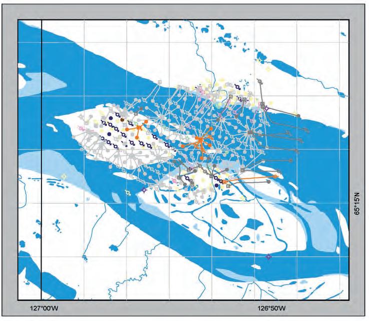
It was during this period that the first deviated well was drilled by Imperial in 1943 and virtually all wells since 1956 are reported as deviated. To date over three hundred deviated wells have been drilled to access this oil, some of these wells reach a considerable distance under the river. Further drilling is taking place in this remote area as companies pursue oil from the Canol Shale, which has long been recognised as the source rock for the Kee Scarp but with new technology now has the potential to be a viable target.
The difference between deviated wells and horizontal wells does not appear to have been consistently applied; a deviated well typically enters the target zone either vertically or at an angle resulting in limited thickening of the reservoir in the wellbore, while a horizontal well is intentionally drilled horizontally within the target formation, therefore accessing considerably more of the reservoir rock. Schlumberger’s definition of a horizontal well is one where departure of the wellbore from vertical exceeds about 80 degrees.
Much horizontal technology and expertise has evolved in the United States, the following summary looks at some of the early experimentation with true horizontal drilling in Canada.
1978: Imperial Oil Resources drilled the first productive horizontal well in Canada at 1AB/07-06-065-03W4/00. This was part of Imperial’s Cold Lake development for extracting bitumen from the Clearwater Formation. The well was a success and has subsequently produced over 512mbo to 2006.
1980: Texaco Canada Petroleum Inc. drilled a pair of horizontal wells into the McMurray Formation at 12-15-08808W4/00 in Athabasca for bitumen. The steam injector and producer yielded some oil, as did a third well in the same location in 1981.
1987 (August): Alberta Energy Company
16 RESERVOIR ISSUE 10 • NOVEMBER 2012
Figure 1. Norman Wells Field, NWT, Canada illustrating the different phases of development drilling using both vertical and deviated wells.
drilled the first productive horizontal well in a conventional oil reservoir for the Glauconitic Sandstone at Suffield in southern Alberta.
1987: Peter McKenzie-Brown (Oilweek, June 2012) pointed out that the Alberta Oil Sands Technology and Research Authority (AOSTRA) opened their Underground
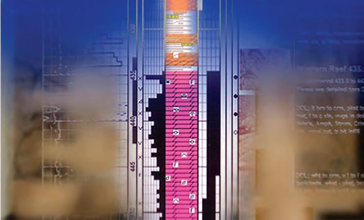
Test Facility (UTF) in the summer of 1987. It could be argued that this was truly the mother of all horizontal drilling in Western Canada. A pair of horizontal tunnels approximately five metres in diameter were drilled into the Devonian limestone below the oil sands. Steam injection and production wells were then drilled at a slant upwards from these tunnels into the base of the oil sands where they were deflected horizontally. This was the test facility that helped prove the concept of Steam Assisted Gravity Drainage (SAGD) that has dominated in-situ bitumen production since that time.
1988: Amoco Canada Petroleum Company initiated a ten-well horizontal drilling program in the Wabiskaw Formation at Athabasca while a number of other companies were experimenting in the Cardium, Sparky, Cummings, Glauconitic, Nisku, Keg River, and Jean Marie. The diversity of reservoir rock varied from conventional clastic rocks to low-permeability carbonates accessing a range of products from natural gas, to light oil, heavy oil, and bitumen.
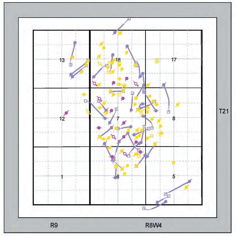
In the early 1990s, the main focus of horizontal drilling was to increase production from existing conventional reservoirs. The typical approach being to recovery factors across a pool, identify areas of poor recovery, and drill horizontal wells between the existing vertical well control. Figure 2 illustrates
(Continued on page 18 ...)
RESERVOIR ISSUE 10 • NOVEMBER 2012 17
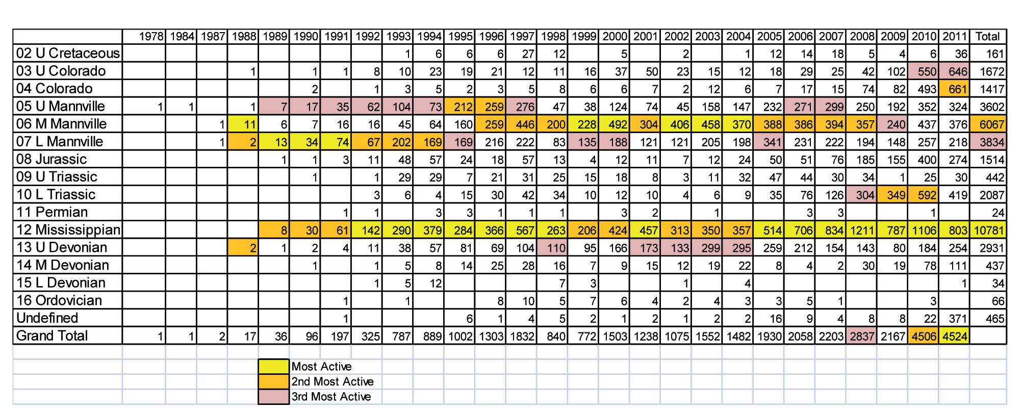
Figure 3. Distribution of productive horizontal wells by epoch and year of rig release. The three most active epochs each year and all time are highlighted.
Figure 2. Jenner Field horizontal drilling in the 1990s.
1990s horizontal activity in the Middle Mannville, Glauconitic Formation at Jenner in southeastern Alberta where horizontal drilling attempted to extract more oil from unswept portions of the pool. The end result, in plan view, looks more like a golf course layout with well lengths and orientations appearing randomly placed across the field but targeting portions of the reservoir with low-recovery factor.
and Mississippian have been consistent gold and silver medal performers, with a number of other epochs providing a challenge in recent years.
The Mississippian has been the first or second most-active epoch ever since 1989; however, the principle target has changed from conventional Mississippian subcrop plays of southeastern Saskatchewan to the underlying Bakken in recent years.
Other significant trends in recent years include the accelerated activity to produce gas from the thick, unconventional reservoir units of the Montney Formation that started to affect the number of Lower Triassic wells in 2007. The downturn in gas prices starting in 2009, while oil price remained robust, accounts for the drop in gas activity and the rapid growth in interest in oily formations like the Cardium and Viking (represented by the Upper Colorado and Colorado drilling statistics respectively). (...Continued
Since that time, activity has accelerated virtually every year with the targets varying according to the relative profitability of oil, bitumen, and natural gas. Figure 3 shows the number of productive horizontal wells by epoch each year, providing a snapshot of how industry activity is distributed.
Splitting the activity by epoch does mask many significant plays and can distort the results if, for example, the Mannville is lumped as a single group or the Bakken is split from the Mississippian. In the horizontal-drilling Olympics, the Mannville
The Mannville has always attracted attention, largely because it is the most widely distributed and stratigraphically variable reservoir rock, and also because it has the greatest variability of reservoir product. The application of horizontal drilling has covered the full spectrum from bitumen to dry gas and more recently liquids-rich gas.
Activity in the Upper Devonian has covered virtually every formation with the Jean Marie dominating results in the early 2000s.
GEOEDGES INC.
Texas & Midcontinent US Geological Edge Set
Western Canada: Slave Point, Swan Hills, Leduc, Grosmont, Jean Marie, Horn River Shales, Elkton, Shunda, Pekisko, Banff, Mississippian subcrops and anhydrite barriers in SE Sask., Bakken, Three Forks, Montney, Halfway, Charlie Lake, Rock Creek, Shaunavon, BQ/Gething, Bluesky, Glauconitic, Lloyd, Sparky, Colony, Viking, Cardium, Horseshoe Canyon and Mannville CBM, Oilsands Areas, Outcrops
US Rockies & Williston: Red River, Mississippian subcrops & anhydrite barriers (Bluell, Sherwood, Rival, etc), Bakken, Three Forks, Cutbank, Sunburst, Tyler, Heath, Muddy, Dakota, Sussex, Shannon, Parkman, Almond, Lewis, Frontier, Niobrara, Mesaverde shorelines, Minnelusa, Gothic, Hovenweep, Ismay, Desert Creek, Field Outlines, Outcrops
Texas & Midcontinent: Permian Basin paleogeography (Wolfcampian, Leonardian, Guadalupian), Granite Wash, Mississippian Horizontal Play, Chat, Red Fork, Morrow, Sligo/Edwards Reefs, Salt Basins, Frio, Yegua, Wilcox, Eagleford, Tuscaloosa, Haynesville, Fayeteville-Caney, Woodford, Field Outlines, Outcrops, Structures
North American Shales: Shale plays characterized by O&G fields, formation limit, outcrop, subcrop, structure, isopach, maturity, stratigraphic cross-sections. Includes: Marcellus, Rhinestreet, Huron, New Albany, Antrim, Utica-Collingwood, Barnett, Eagleford, Niobrara, Gothic, Hovenweep, Mowry, Bakken, Three Forks, Monterey, Montney, Horn River, Colorado
Eastern US / Appalachia: PreCambrian, Trenton, Utica-Collingwood, Medina-Clinton, Tuscarora, Marcellus, Onondaga Structure, Geneseo, Huron, Antrim, New Albny, Rhinestreet, Sonyea, Cleveland, Venango, Bradford, Elk, Berea, Weir, Big Injun, Formation limits, Outcrops, Allegheny Thrust, Cincinatti Arch, Field outlines
Deliverables include:
-Shapefiles and AccuMap map features
-hard copy maps, manual, pdf cross-sections
-Petra Thematic Map projects, GeoGraphix projects, ArcView map and layers files
-bi-annual updates and additions to mapping
-technical support
18 RESERVOIR ISSUE 10 • NOVEMBER 2012
page 17) Western Canada Geological Edge Set Northern US Rockies
Basin Geological Edge Set Eastern US / Appalachian Basin Geological Edge Set North
Geological
Set Detailed
for information contact: Joel Harding
403
email joelharding@geoedges.com
from
& Williston
American Shales
Edge
and accurate geology at your fingertips in Petra, GeoGraphix, ArcGIS, AccuMap, GeoScout and other applications
at
870 8122
www.geoedges.com
Five Great Days of the Finest Geoscience Training for One Low Price
List of Topics::
• Risk and Uncertainty for Contemporary Prospect Evaluation
• Asset Management in Unconventional Plays
• Geocellular Modeling in Unconventional Resources
• Carbonate Reservoir Geology
• Carbonate Seismic Sequence Stratigraphy
• Carbonate Depositional Systems
• Quick Guide to Carbonate Well Log Analysis
• Geological Interpretation of Seismic Data
• Seismic Amplitude Interpretation
• Interpretation of 3D Seismic Data
• Principles and Applications of Well Logging
• Formation Evaluation of Thinly-bedded Reservoirs
• “Old” (Pre-1958) Electric Logs: A Quick Review
• Data Acquisition Methods and Completion Techniques
(Four concurrent sessions each day – mix and match according to your interests and training needs. Buffet lunch and refreshments included each day.)
Small AAPG Bookstore open during breaks each
Tuition for the
(Your five-day badge can be transferred to a friend or colleague if you can't attend all five days.)
Hosted by the Norris Conference Center: 803 Town & Country Lane Houston, TX 77024
Phone: 713-590-0950
Fax: 713-590-0961
Special group rate at nearby Hotel Sorella
Registration and information:
Toll-free (U.S. and Canada) 888-338-3387, or 918-560-2650
Fax: 918-560-2678
E-mail: educate@aapg.org
Download a registration form at: www.aapg.org/education/wec.cfm
RESERVOIR ISSUE 10 • NOVEMBER 2012 19
week: AAPG Members..........................$1795 $1995 Non Members............................$2095 $2295 Individual Courses....................$500day $550/day
SIGN UP NOW!
WINTER EDU CATION CONFERENCE BY BECOMING AN AAPG MEMBER AND REGISTERING BEFORE JAN. 14 th 10 th ANNUAL HOUSTON, TX • FEBRUARY 11-15, 2013 Price increase after 1/14/2013 Price through 1/14/2013 SAVE $ 500
day
ROCK SHOP


20 RESERVOIR ISSUE 10 • NOVEMBER 2012 Strip Log Strip Log Horizontal Log Horizontal Log Mud Log Mud Log Log Viewer Log Viewer Log Manager Manager Log Analysis Log Analysis Suite 102, 7370 Sierra Morena Blvd SW, Calgary, AB T3H 4H9 info@WellSight.com 1-800-447-1534 (403) 237-9189
Excellence in Geological Services for Over 20 Years Integrated Reservoir Studies for All Resource Types 4D Geomodelling & Geosteering Horizontal Well Path Planning Infill Well Placement Studies SMART4D Modelling ® Software www.uogc.com 403.265.0111 91 0 , 396 11th Ave SW C a lgar y, AB Cana da WELLSITE GEOLOGICAL SUPERVISION Cell403 819 2516 farhat@sableconsultants.com SABLECONSULTANTS.COM Conventional Wells Coring Programs Heavy Oil/Oil Sands Coal Bed Methane SAGD Horizontal Project Supervision www.rpsgroup.com/energy (403)263-0449 17084 Global Leaders in Wellsite Geology Serving the petroleum industry for over 25 years ■■ Conventional Vertical / Horizontal Wells ■■ Unconventional Heavy Oil / CBM Wells ■■ International WSG / Operations Geology • Domestic and International wellsite supervision • Conventional and Unconventional wells • Extensive Hz experience • Customized corporate solutions available (403) 250-3982 sales@clconsultants.ca www.clconsultants.ca *Domestic & International Supervision 906, 505 6 St. SW Calgary, AB T2P-1X5 Jocelyn Lampron, P. Geol. President & CEO Wellsite Geological Supervision *Conventional Wells-Heavy Oil/SAGD *Coal Bed Methane Wells www.hopewellpetroleum.com info@hopewellpetroleum.com CD N BA CD BA n yevr 234 765 101112 15 8 9 16 1413 23456 11 10987 1716151413 2322212019 2627282930 35 12 18 24 25 36 34333231 section lsd township ph: 403.266.3132 cell: 403.818.8549 *On & Offshore Geological Supervision
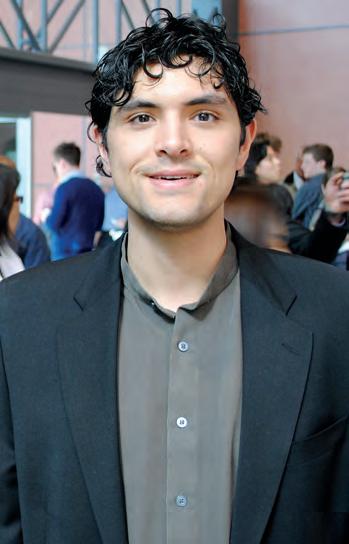
2012 A N DREW D. B A ILLIE AWARDS
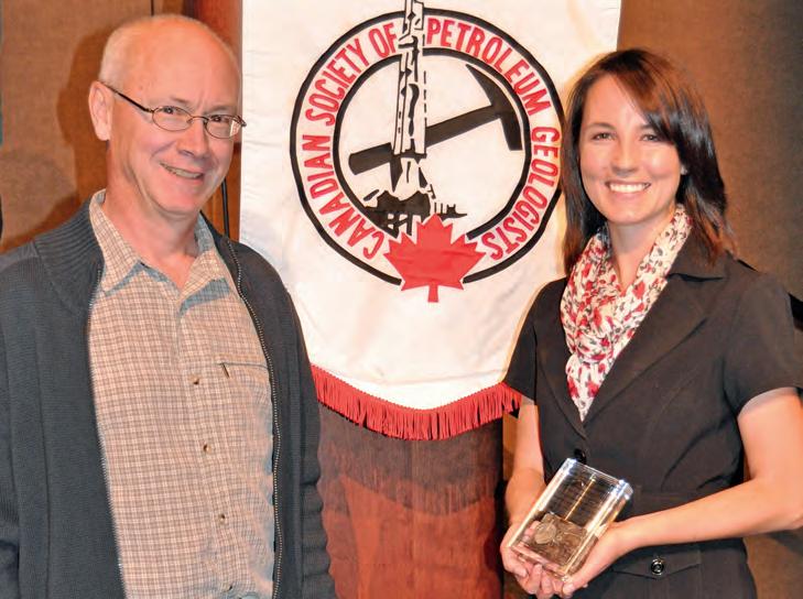
The CSPG Educational Trust Fund is pleased to announce the recipients of the 2012 Andrew D. Baillie Award. The award is given for the best student poster presentation and the best student oral presentation at the Society’s joint annual convention.
The award recipient for the best student poster presentation was Janelle Irvine from the University of Canterbury, New Zealand. The geoConvention: Vision 2012 award committee selected Janelle’s presentation entitled “The sedimentary record of the transition from passive to active tectonic settings; North Canterbury Basin, New Zealand,” to be the best of an excellent group of student posters at the 2012 geoConvention.
Peter Gagliardi from the University of Calgary was granted the award for the best student oral presentation for his presentation entitled, “Orientation analysis of borehole geophones in vertical and deviated wells: calibration consistency.”
The Baillie award is in memory of Andrew Dollar “Andy” Baillie (1912-2001) who had a geological career that spanned five decades. His petroleum career began with the British American Oil Company, the precursor to Gulf Canada, in 1953. After retiring from Gulf, Andy spent more than 20 years pursuing his passion for teaching geology in a variety of ways. His technical skills and desire to share his knowledge made
him an invaluable asset to the geological community.
In 1997, to celebrate his lifetime of geological involvement, the CSPG awarded Andrew Baillie the Stanley Slipper Gold Medal for “life-long accomplishments and outstanding contributions to petroleum geology in Canada and abroad.” He was an inspiration to literally hundreds of geologists, who came under his influence, however fleetingly, during his life. Andy was an active member of the CSPG and had a particular interest in the CSPG Educational Trust Fund and the award in his name was established in
1991. The award recognizes excellence in technical presentations by students and encourages a level of technical prowess worthy of Andrew D. Baillie.
The 2012 Baillie awards were presented at the September 11th CSPG Technical Luncheon.
ROCK SHOP
RESERVOIR ISSUE 10 • NOVEMBER 2012 21
Janelle Irvine receiving the 2012 Andrew D. Baillie Award for best student poster presentation from Educational Trust Fund Interim Chair, Steve Dryer.
Peter Gagliardi received the 2012 Andrew D. Baillie Award for best student oral presentation.
24T H A N NUAL C SPG/CSEG/CAPL
10K & 5K Road Race and Fun Run
| By Mike Cardell, Committee Chair
On a perfect fall afternoon Sept 12th, 2012 the annual CSPG/CSEG/CAPL road race and fun run took place along the Bow River Pathway. The temperature was ideal for running, and a very enthusiastic group of 166 runners bolted from the start line. This year marked the 5th year for the 5K, and again we saw an increase in participants to 67 runners.
The new route (no detours) went by the Peace Bridge then followed the Bow River Pathway west. Our race volunteers, decked out in bright orange safety vests, aided the runners in negotiating the route. Once again distances were marked uniquely in geologic time to assist, or perhaps confuse, the participants. Like every year it’s great to see a mix of competitive and first-time runners. Winning Time once again provided timing with the race chip mounted conveniently on the runners’ race bib.
We returned to The Calgary Curling Club for the post-race awards party, where the mix of racers and volunteers enjoyed plenty of cold beverages and a pasta dinner. The evening was topped off with door prizes, awards and, of course, our now infamous sock-toss. Through great sponsorship and strong participation, we are once again able to contribute to our designated charity the YMCA Strong Kids Foundation!
I would like to thank all the volunteers and sponsors who helped make this event a success! We have acknowledged our sponsors on a separate page. Thank you also to all the runners. It was a pleasure cheering you in at the finish line.
Finally a huge thank-you to our group on the committee that made this all work: Kathy Waters, Jocelyn Frankow, Tina Donkers, Shirley Fleming, Dan Cicero, Greg Hayden, Tim Burk, Armin Schaffer, and Emma MacPherson at the CSPG office. As well, thanks to Nick Wiggins and the staff at the Eau Claire YMCA for their hospitality.
For more information on run times and placement, please see www.winningtime.ca We look forward to seeing you next year for the 25th Annual Road Race and Fun Run. Race date will be September 11, 2013.
Thank you.
Mike Cardell, Race Director (mcardell@arcis.com).
22 RESERVOIR ISSUE 10 • NOVEMBER 2012
H E RE ’ S A S u mm A RY o F THE CSPG, CSEG AND CAPL WINNERS FRo m 2012: ov E RALL To P mALE 10K R E S u LTS PlaceTime Race # Div Name Member 1 36:40.34523M3039 John RUSSELL CSEG 2 37:24.85464M3039 Mark DAHL CSPG 3 38:04.58494M-U30 Justin KANGARLOO CAPL 4 38:25.36498M3039 John LAUGHTON CSPG 5 39:09.35553M4049 Niclas CHRISTOFFERSSON CSEG ovERALL ToP FEmALE 10K RESuLTS PlaceTimeRace#Div Name Member 1 41:53.83493F3039 Rhonda JEWETT CSEG 2 42:30.82468F3039 Kellie D’HONDT CAPL 3 43:35.34506F-U30 Jane MARZETTI CSPG 4 44:33.35477F4049 Shirley FLEMING CSEG 5 46:01.09546F3039 Erin LINLEY CSPG To P m A LE CSPG 10K RES u LTS PlaceTime Race # Div Name Member 1 37:24.85464M3039 Mark DAHL CSPG 2 38:25.36498M3039 John LAUGHTON CSPG 3 41:15.82465M6069 Barrie DARGIE CSPG 4 41:27.84512M5059 Michael MOKIEVSKY-ZUBOK CSPG 5 41:59.09529M4049 Claus SITZLER CSPG To P F E m A LE CSPG 10K RES u LTS PlaceTime Race # Div Name Member 1 43:35.34506F-U30 Jane MARZETTI CSPG 2 46:01.09546F3039 Erin LINLEY CSPG 3 46:59.84457F-U30 Danielle KONDOLA CSPG 4 47:42.08545F3039 Justine SAGAN CSPG 5 48:36.34449F-U30 Heather ARCHIBALD CSPG To P m A LE CSPG 5K RES u LTS PlaceTime Race # Div Name Member 1 23:55.08 239M-U30 Matthew ROBICHAUD CSPG 2 30:45.59 248M70+ Robert TAUER CSPG 3 30:58.11 218M3039 Aaron GRIMEAU CSPG 4 31:55.34 235M3039 Sandy OCHOA CSPG 5 33:58.58 243M5059 Randy SMITH CSPG To P F E m A LE CSPG 5K RES u LTS PlaceTime Race # Div Name Member 1 22:23.32 225F-U30 Rachel LEA CSPG 2 25:14.85 249F4049 Tamara TOON CSPG 3 26:04.60 213F5059 Tina DONKERS CSPG 4 28:07.85 230F-U30 Tara MAILANDT CSPG 5 28:22.10 227F3039 Fiona MACDONALD CSPG
24th Annual CSPG/CSEG/CAPL 10K & 5K Road Race
Thank you to our sponsors


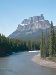
GO TAKE A HIKE Muskeg Falls, Grande Cache, Alberta
| By Philip Benham and Christopher Collom
trailhead: Drive 16 km southeast of Grande Cache on Hwy 40. An unmarked trail proceeds from a rest stop on the north side of the highway.
distance: 2.5 km round trip. Mostly flat, meandering trail until near the end where a right turn and a minor scramble is required to reach the falls. Stay away from the undercut cliff to the left on your descent and take care at the falls viewpoint where the rocks can be slippery.
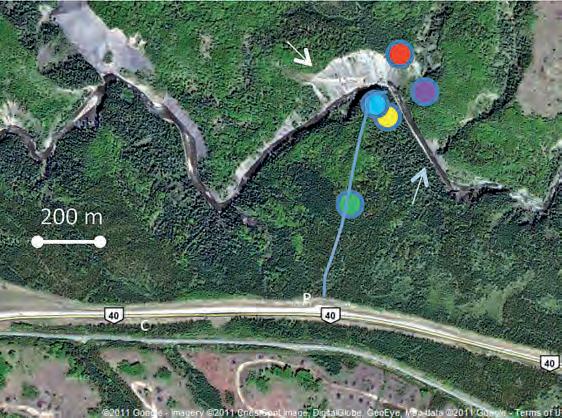
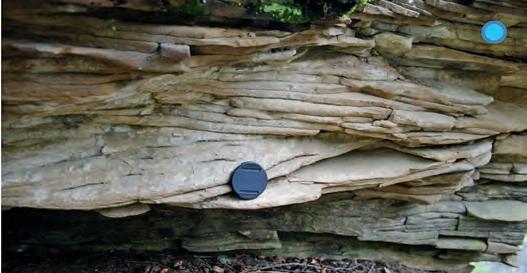
elevation gain: 50m descent to waterfall. If you visit the Cardium outcrop (C) be aware of industrial and recreational highway traffic when you park and stay off the road in your explorations.
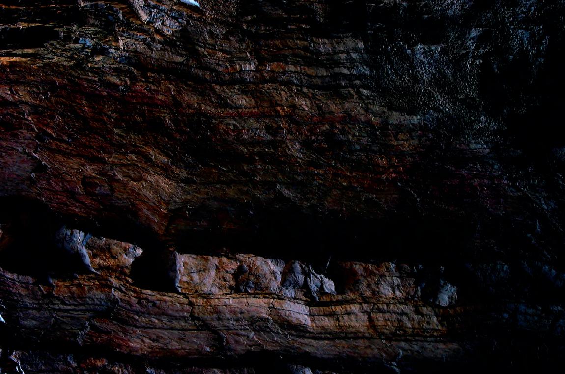
This short trail to a landmark with a gem of a view only seems to be known locally: Muskeg Falls. The Muskeg River makes its way westwards until it encounters a resistant bed of sandstone. It deflects NW in a straight line along the bedding surface for about 600m (indicated by blue arrow) before finding a weak point (perhaps a fracture or minor fault offset) and cutting through it at the thundering Muskeg Falls. After a heavy rain the river swells, becomes turbid with mud and rafts numerous logs that have fallen down its steep banks. The ledge-forming sandstone (part of the shale-dominated Late Santonian to Early Campanian Wapiabi Formation) dips moderately to the northeast. It stands out in the satellite photo to the left (see white arrow), in the mudstone-dominated slopes immediately downstream of the waterfall.
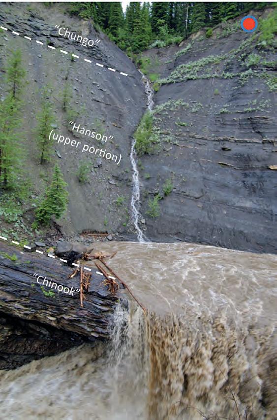
The Upper Wapiabi, partly equivalent to the well-known Puskwaskau, is the last gasp of the Western Interior Seaway, which, for most of the Cretaceous stretched from the Gulf of Mexico to the Arctic Ocean. Within it are several sandstone packages that have initiated strong debate as to their correlation between southern and central Alberta. Two sandstones are visible at the waterfall viewpoint. Stott (1963) considered them to be the Chungo and Nomad members respectively. More recently Collom (2001) identified them as the ‘Chinook’ (or so-called Highwood Sandstone) and Chungo, and places the Nomad higher in the section. The lowest one, forming the ledge, exhibits features common in storm-dominated shelf to upper shoreface settings such as hummocky cross-stratification and gutter casts. The sandstone beds thicken upwards and then amalgamate through the shoaling cycle. If you observe the bed’s top surface at the waterfall viewpoint, you will notice large sideritic, red branching burrows (Thallassinoides) and stringers of chert pebbles. The pebbles are a transgressive lag deposit, related to the relative deepening of the sea level. Overlying this sand are black jarositic mudstones.
Another outcrop, 500m west of the rest stop (see ‘C’ on map) – on the south side of the road, offers a chance to compare older marine shoreline cycles (Cardium Formation; Turonian) at much closer quarters. Here thinly bedded, heavily bioturbated sandstones and shales coarsen up into hummocky cross-stratified and pebbly sandstones capped by coalbearing continental strata.
references: Collom, C.J. 2001. Systematic Paleontology, Biostratigraphy and Paleoenvironmental Analysis of the Upper Cretaceous Wapiabi Formation and its Equivalents.
Unpublished Ph.D. Dissertation, University of Calgary, 807 p.
Stott, D.F. 1963. Geological Survey of Canada Memoir 317, 306 p. Tschudy, D., Donaldson S.W., Collom, C, Feldmann, R.M., and Schweitzer C.E. 2005. Journal of Paleontology, v. 79, no. 5, (Sep., 2005), p. 961-968.
Background
by Astrid Arts.
Photo
Muskeg Falls after a heavy rain. Note the muddy waters and logs perched on the edge of the falls. Black mudstones with thin storm-generated sands sits between the Chinook and Chungo.
24 RESERVOIR ISSUE 10 • NOVEMBER 2012
On the return climb you will notice this outcrop of swaley to hummocky cross-stratified sandstone of the Chinook; these sedimentary structures result from storm-generated, high-energy currents transporting sediment on the shelf.
Large branching burrows, (a trace fossil known as Thallassinoides) with knobby pellet-lined walls. These burrows were likely produced by Hoploparia, a clawed lobster. (Tschudy et al, 2005). The pellets are balls of its excreta used to stabilize the walls in the shifting sands. The burrows have preferentially cemented with siderite making then rusty red in colour.
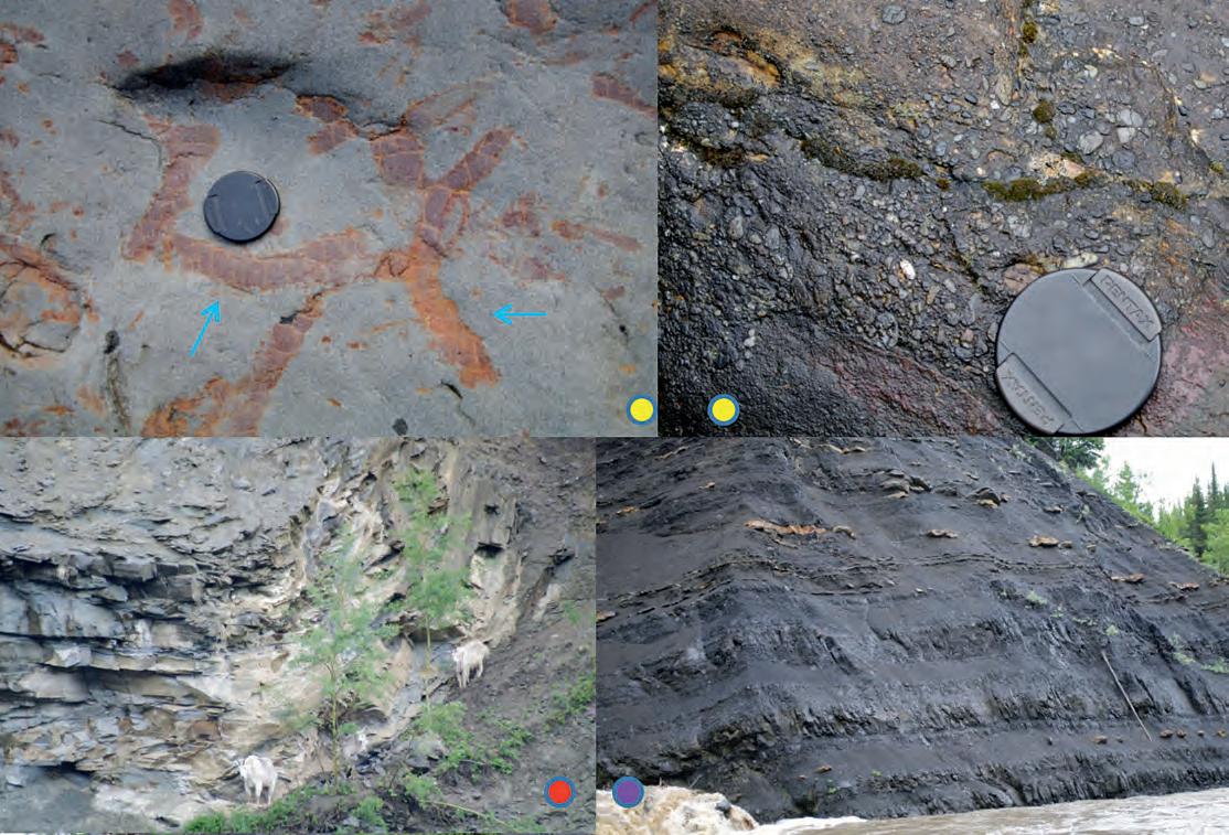
Pebbly lag sitting at the top of the Chinook sandstone. Both can be seen in the rocks at the end of the trail along the river upstream of the waterfall.
goats scramble on a steep slope adjacent to a folded portion of the
Dark grey to black mudstones between the Chinook and Chungo. Note the beds rich in sideritic concretions that may contain ammonites, bivalves and rare decapods. Turbid flows of sediment along the ocean floor generated by storms in shallower parts of the shelf have introduced thin sands into this setting.
The Reservoir Committee welcomes contributions from our readership to this series. If you wish to offer a submission to Go Take a Hike on your favourite hike of geological interest, email the Reservoir at Emma. MacPherson@cspg.org for more information.
and
Mountain
Chungo Member.
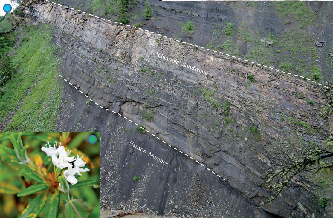
The “Chinook” Sandstone topping the upper Hanson Member. Its lower portions contain gutter casts
tempestite deposits, the sands coarsen and thicken upwards, finally amalgamating in a thick package of hummocky-swaley cross-bedded sandstone. This is capped with a veneer of chert pebbles, which are a transgressive lag deposit. The overlying mudstones represent a return to quieter conditions in deeper water. Inset on Bottom left: Labrador tea in bloom.
RESERVOIR ISSUE 10 • NOVEMBER 2012 25
2011-2012 CSPG U N IVERSIT y ST UDENT EVENT Grant Winners
| By Melanie Klucker
This past academic year, the CSPG introduced a new grant opportunity available to university student groups. These grants, funded by the CSPG Education Trust Fund (ETF), aim to support student field trips or other educational initiatives related to sedimentary or petroleum geology. Recently, five CSPG Student Event Grants, worth $1,000 each, were awarded to student groups at universities from across Canada: Queen’s University (Adirondacks trip), Simon Fraser University (US west coast trip), University of Calgary (Geoscience Research Exchange, see October issue), Acadia University (southern Nova Scotia outcrop trip), and University of New Brunswick (Ireland and Scotland trip).
Queen’s CSPG Student Chapter used their grant funds to offset costs of an undergraduate field trip to the Adirondacks. During this trip, the students examined Early Ordovician to Middle Devonian carbonate and siliciclastic rocks deposited in a variety of environments common to many prolific petroleum plays. According to Judith Elliott, the current Queen’s CSPG Student Chapter president, “Exposure to field examples of these environments and the discussion of their importance for petroleum geology has given students a better insight into the applications of what they are learning in their courses.” Through fieldwork completed on the trip, participants also develop fundamental skills, essential to the working geoscientist. As faculty trip leader Dr. Dalrymple explains, students “learn the art of describing sediments … and of using those observations to arrive at sophisticated process and environmental interpretations.” From a student perspective, one of the most memorable experiences for participants was the unique opportunity to get to know and collaborate with geoscience students at different stages in their program.
The Student Event Grant recipients from Simon Fraser University were members of the Applied Research in Ichnology and Sedimentology (ARISE) group. ARISE is made up of graduate students working under the supervision of Dr. Dashtgard and Dr. MacEachern. The ARISE students’ research centres on sedimentology, ichnology, and stratigraphy of marine depositional environments. The group’s primary aim is to integrate modern depositional research with studies of ancient environments interpreted from the rock record. Much of this research
focuses on questions important to the petroleum industry.
On their return trip from the AAPG-SEPM annual convention and exhibition in Long Beach last April, the group made their way north along the western US coast. This roadtrip gave the students opportunities to study both the ancient and modern in the field, with stops to examine ancient marine siliciclastic deposits as well as processes controlling sedimentation and trace-making organisms in modern environments.
According to Brittan Jones, a trip participant, “Such field trip opportunities are rare and the added insight is invaluable.” The knowledge and skills from these field experiences are directly applicable to the role of a petroleum geologist. As Brittan further explains, “this field study helped to increase the group
members’ understanding of depositional architectures within shallow-marine settings, and enhanced their appreciation of the potential for along-strike and down-dip reservoir heterogeneities.”
The CSPG recognizes the value of such field experiences and appreciates that it can be a challenge for students to find accessible opportunities. By supporting events like the Queen’s CSPG Student Chapter Adirondacks trip and the ARISE west coast field trip, we hope to help more students get out into the field. Thank you to all 2012 applicants for making this new CSPG initiative a success and stay tuned for future articles about other grant winners. The application deadline for the 2012-2013 grants will be March 8, 2013 and we look forward to supporting future events organized by students from universities across Canada.
26 RESERVOIR ISSUE 10 • NOVEMBER 2012
Queen’s University Geology students, Lake Champlain, New York, inspecting an Ordovician shallow-marine carbonate succession.
Simon Fraser University ARISE group at Austin Point, Hug Point State Park, Oregon. Back row (left to right): Dr. J. MacEachern, Brittan Jones, Stacy Johnson, Korhan Ayranci, Joanna Czarnecki, Dr. S. Dashtgard. Front row (left to right): Adam Montgomery, Liam Ricci, Dr. A. Morshedian, Andrew La Croix.
PHOTO OF THE MONTH
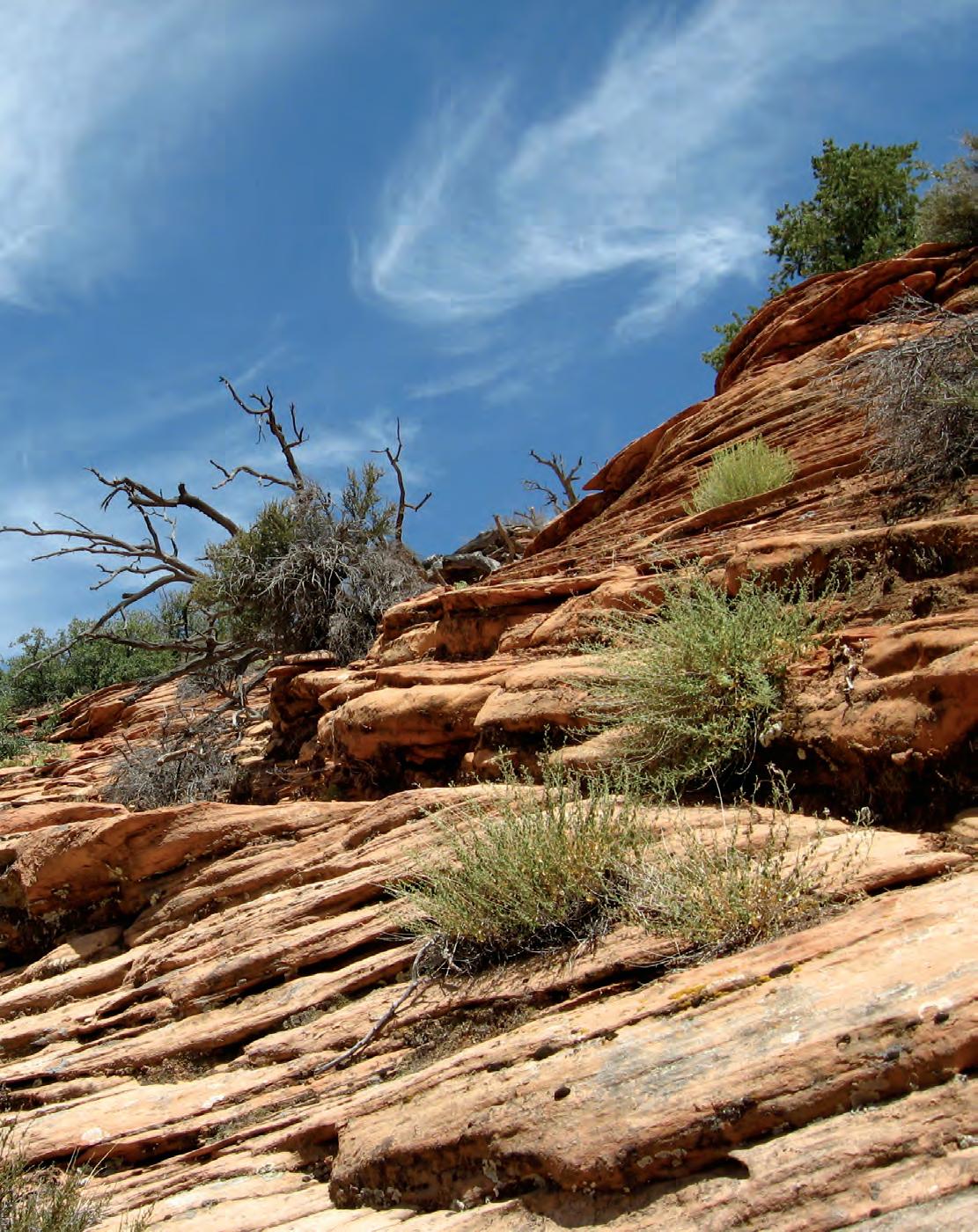 Large scale cross-bedding in aolian sandstone of the Navajo Formation, Zion National Park, Utah. Photo by Paul Kavanagh.
FROM THE REGULATOR’S DESK: Carbon Capture and Sequestration
| By Alex Bolton and Curtis Evans
Notes on regulatory issues for industry geologists from regulatory colleagues at the Energy Resources Conservation Board (ERCB).
The design and implementation of carbon capture and sequestration (CCS) schemes require specific geoscience knowledge and input, among several other disciplines and skills. It is the geoscience aspects of CCS schemes that capture much of the media and public attention, so this briefing is intended to provide the basic knowledge that we need as geoscientists to be able to speak knowledgably about CCS. The details are mostly specific to Alberta, but the principles are applicable across Canada and worldwide. This article deals mostly with the geotechnical aspects of sequestration in the subsurface. Many other important aspects of the schemes – the engineering aspects of capturing carbon dioxide ( CO 2 ) and transporting it through pipelines to the injection wells; monitoring, measurement, and verification of the project; and the long-term liability issues – are not discussed here.
The ERCB has been regulating the disposal, storage, and injection of fluids to underground geologic formations in Alberta for many years – and with respect to CO 2 , for more than 20 years. The ERCB has processes in place to provide for the effective regulation of these activities, including the more than 50 schemes involving CO 2 currently operating in Alberta.
W H y C CS?
The governments of Canada and Alberta have both identified CCS as an important part of their CO 2 reduction strategies. The Government of Canada supports the reduction of greenhouse gas (GHG) emissions through its Clean Energy Fund and is aiming to reduce CO 2 emissions by 325 megatonnes per year by 2050 through a number of approaches, including CCS.
Alberta released its ‘Climate Change Strategy’ in 2008, in which it committed to reducing GHG emissions by 200 megatonnes per year by 2050. Under the plan, CCS is expected to provide 70 per cent of the GHG emissions savings. The goal of CCS projects in Alberta is to reduce GHG emissions generated from coal-
fired power plants and upstream oil and gas activities, particularly bitumen mining and processing. As a result of oilsands development the oil and gas sector’s share of CO 2 emissions rose dramatically from 1990 to the present. The intent is that CCS will help develop oil sands resources with a smaller carbon footprint.
CCS IN A L BERTA
To facilitate the development of CCS projects in Alberta, the Alberta government enacted several pieces of legislation and regulation—the Carbon Capture and Storage Funding Act and its associated regulations. Among other things, this legislation set up a fund to enable large-scale CCS projects, established the framework for long-term liability, and created a process for pore-space access for long-term geological sequestration of CO 2 – all pre-requisites for CCS project development.
Currently there are no facilities in Alberta operating specifically and exclusively to store and sequester large quantities of CO 2 . However, in July of this year, the ERCB approved the Shell Canada Quest CCS project in Central Alberta and in early September the company announced the Quest project would be going ahead as planned and approved. This type of CCS project could enable future development of bitumen from the oil sands with fewer CO 2 emissions, as well as provide knowledge and understanding that might help accelerate implementation of other CCS projects around the world.
C ONTAINMENT IN THE S UBSURFACE
For most geoscientists, it is the containment of the fluids in the subsurface rocks that is of primary interest. As the regulator, the ERCB must be satisfied that the injected CO 2 can be sequestered safely and that containment in the reservoir will be maintained over geologic time.
Most of the Western Canada sedimentary basin (WCSB) rests on a highly stable, cratonic landmass that experiences little seismic activity. In 2000, the Alberta Geological Survey issued a report1 on the suitability of Alberta’s subsurface for CO 2 sequestration. This report identified
areas of Central Alberta as extremely suitable, noting the occurrence of oil and gas reservoirs, deep aquifers, coal seams, and salt beds that provide both storage reservoirs and seals.
T HE RESERVOIR
For its Quest project, Shell selected a deep saline aquifer in Central Alberta as the proposed reservoir for sequestration of CO 2 . The ERCB, in its hearing decision report 2 on the project, examined the selection of the proposed Basal Cambrian Sand in the Redwater area as an appropriate reservoir for CO 2 sequestration. Its evaluation of the scheme took into account a number of geological factors regarding the suitability of the area for CCS. These included the areal extent of the reservoir, the nature and sealing capacity of the overlying rocks, the wells in the area that penetrated the reservoir and seals, and any faulting within the full sedimentary sequence.
In the Redwater area, the Basal Cambrian reservoir is a clean, fine- to coarse-grained sandstone with minor shale intercalations, consisting of contiguous sheet sands about 35-46 m thick across the whole area. It is a saline aquifer that occurs at 1,8002,100 m below ground level. The average reservoir properties at the injector wells are expected to be a porosity of 11 to 19 per cent and permeability of 20 to 500 mD.
T H E SEALS
A number of seals are directly associated with the Basal Cambrian Sand reservoir, as well as several more in the overlying section. The first seal immediately overlying the reservoir is the Middle Cambrian shale, above which are two more seals – the Lower and Upper Lotsberg Salts. The Winnipegosis Formation, the first saline aquifer above the basal Cambrian section, occurs at 1,600 m below the surface and is itself capped by another sealing formation in the form of the Prairie Evaporite Formation. Together these seals occur over the entire injection area – and are together more than 250 m thick.
The Precambrian Granite Basement is an unconformity surface and forms the lower seal to the Basal Cambrian Sand.
28 RESERVOIR ISSUE 10 • NOVEMBER 2012
Physico-chemical trapping mechanisms in the reservoir, at a 2,000 m depth and at the temperature of the storage formation, will keep the injected CO 2 fluid in a dense phase. The CO 2 will be permanently trapped by capillary forces at irreducible saturation within the sandstone’s pore spaces. Over time, the CO 2 will become even more securely trapped as it dissolves into the brine in the storage formation. The relative amount of CO 2 that would be stored by the various physico-chemical trapping mechanisms is based on wellestablished CO 2 -fluid interactions. It is estimated that after 50 years (i.e., 25 years after the end of injection), 60 per cent of the CO 2 would still be mobile, 25 per cent would be residual, and 15 per cent would be dissolved (i.e., in solution).
A BANDONED WELLS
O ne of the main risks to sequestering any fluids in the subsurface is the proximity of abandoned wellbores to the injector wells. If injected fluids were to come in contact with a poorly abandoned wellbore through the reservoir and seals section, those fluids – in this case, CO 2 in a dense phase – could conceivably contaminate shallower
zones or even leak to the surface. In the case of the Shell Quest project, only four abandoned wells penetrate the reservoir and seals, and these wells are a long way from the proposed sequestration project, the nearest one some 20 km away. Additionally, since these wells were drilled and abandoned between 25 and 60 years ago, it is most likely that these potential conduits have been closed by salt flow into the well bores.
FAULTING
The underlying rocks in Central Alberta are Precambrian – about 1.5 billion years old – and have been eroded to a relatively smooth surface tilted gently to the southwest. The entire area appears to be tectonically stable. The risk, of course, is that faulting in the Precambrian surface might have been reactivated and penetrated the sedimentary section above.
Seismic data indicate that no faults breach the reservoir or seals, which might provide a pathway to shallower formations. While small faults and fractures can be seen within the Precambrian surface – likely the result of terrane collisions – none interrupting the regional seals have been identified from either 2-D or 3-D seismic data.
As well, the pressure differences between the Basal Cambrian and the Cooking Lake Formation provide additional evidence that the faults in the Precambrian do not penetrate the reservoir or seals. The Upper Devonian Cooking Lake Formation is under-pressured for its depth, which would be impossible if there were communication between that formation and the normally pressured Cambrian section.
E X TENT AND IMPACTS OF CO 2 PLUMES AND PR ESSURE FRONT
In any CCS project, the CO 2 within the reservoir, once injected, would radially displace the brine. Once injection ceases, the CO 2 would migrate vertically – given its relative buoyancy – and the plume would form an inverted cone shape extending to the largest radius at the top of the reservoir. In the CCS process, the pressure front associated with injection would extend much further into the reservoir than the CO 2 plume itself; the actual distance depends mainly on the total volume injected and the injection pressure. In Shell’s case, the estimated CO 2 plume radii are 500-3,000 m, with a corresponding pressure front of up to 30 km over the 25-year injection life. The (Continued on page 30...)

May 6 -10
Telus Convention Centre and ERCB Core Research Centre
CALL FOR ABSTRACTS
Abstract submissions site of oral, poster, and core presentations for Integration 2013 will open Monday, November 5.
Presentations that integrate the various disciplines of the geosciences, engineering, technology, the environment, and business are preferred. In order to offer something for everyone, we are designing a technical program that will include large, general themes that encourage multi-disciplinary contributions and will focus on various specific areas within a general topic. We are also planning a range of specialized technical sessions focused on advances in specific disciplines.
INVITATION TO SUBMIT
Please contribute to the technical program by submitting an informative and creative presentation that would fit within one of the diverse sessions that have been proposed. A full session listing may be found on the Convention website at www.geoconvention.com.
INCREASE YOUR CORPORATE PROFILE!
Interested in Exhibit, Sponsorship, or Advertising opportunities for the 2013 Convention? Please contact Alyssa Middleton, Assistant Convention Manager, for more information: alyssamiddleton@shaw.ca, 403-453-0181.
RESERVOIR ISSUE 10 • NOVEMBER 2012 29 PH y SICO - C HEMICAL T R APPING M ECHANISMS
For more information visit
www.geoconvention.com
Geo2013_Reservoir_ halfpgAd.indd 1 12-09-17 2:23 PM
CORPORATE MEMBERS
ALLEN GEOPHYSICAL CONSULTING LTD
APACHE CANADA LTD
APEGA
BAKER ATLAS
BDO CANADA LLP
BLACK SWAN ENERGY
BLUEBACK RESERVOIR
CANADIAN NATURAL RESOURCES LTD.
CASEY & ASSOCIATES
CENOVUS
CSEG FOUNDATION
CONOCOPHILLIPS CANADA LIMITED
DE VON CANADA CORPORATION
ENCANA
ENERPLUS CORPORATION
EXXON MOBIL UPSTREAM RESEARCH COMPANY
GEOLOGIC SYSTEMS LTD.
GEOSTRATA RESOURCES INC.
GEOVARIANCES
GLJ PETROLEUM CONSULTANTS LTD
HALLIBURTON
HU NT OIL COMPANY OF CANADA
HUSKY ENERGY INC.
IHS
IMPERIAL OIL RESOURCES
JEWELSUITE
LED SIGNS
LITTLE ROCK DOCUMENT SYSTEMS
LORING TARCORE LABS
MJ SYSTEMS
M URPHY OIL COMPANY
NE XEN INC
PARADIGM
PENN WEST PETROLEUM LTD
PETROCRAFT PRODUCTS LTD
PLUSPETROL S.A.
ROKE TECHNOLOGIES
ROXAR
RPS ENERGY CANADA LTD
SCHLUMBERGER
SHELL CANADA LIMITED
SIGMA EXPLORATIONS INC.
S PROULE ASSOCIATES LIMITED
STATOIL
SU NCOR ENERGY INC
TALISMAN ENERGY INC
TOTAL E&P CANADA LTD.
TOURMALINE OIL CORP.
TUCKER ENERGY SERVICES
U NITED OIL AND GAS CONSULTING
WEATHERFORD LABORATORIES
AS OF SEPTEMBER 10, 2012
Quest project will be closely monitored to assess actual performance relative to expectations.
Given the volumes that could be injected –about 27 megatonnes for the Shell Quest project – it is likely that some surface impacts could result. The increased pore fluid pressure triggered by CO 2 injection into the reservoir in a sequestration scheme causes volume changes that can lead to heaving of the ground surface. This ground heave would be extremely gentle and occur over an extremely wide area. This impact can be modelled and estimated. For the Shell Quest project, the estimates are from 0.6 to 6.0 cm (6-60 mm) of potential ground heave, spread out over the entire pore-space lease area developing over the 25-year injection period.
This amount of potential ground heave originating from a depth of about 2 km is not a significant concern. The magnitude of the effect tapers off gradually towards zero beyond the edge of the affected area, and will largely dissipate with time as pressures equilibrate after injection stops.
DESIGN, CONSTRUCTION AND OPERATION OF I N j E CTION WELLS
The ERCB has well-established design and construction requirements3 for wells that ensure the CO 2 safely reaches the deep storage formation and that shallow nonsaline groundwater is protected. These requirements include up to three layers of casing, each cemented in place to surface, to protect shallow non-saline groundwater. Injection wells must also be designed to limit corrosion of the casing so that pressurized CO 2 can be injected safely. The injector well casing program design also mitigates the possibility of communication between the injection wells except through the reservoir.
It is critical that the CO 2 be injected at a pressure sufficient to move the fluid into the reservoir rock, but not so high as to
exceed the fracture pressure of the sealing formations. The ERCB routinely applies a safety factor to reduce the maximum allowable injection pressure when approving acid gas injection wells, including CO 2 schemes, based on case-specific geoengineering data from mini-frac step rate tests in the injector wells.
E N DNOTE
It is our hope that articles like this will help readers better understand regulatory issues and provide sufficient information to help you have well-informed conversations with family, friends, and neighbours. We are grateful for the opportunity to pass on this information. Putting a public face on the oil and gas sector – especially what it can do to reduce its environmental impacts – can prove extremely effective for everyone.
REFERENCES
1 E arth Sciences Report 2000-11: Suitability of the Alberta Subsurface for Carbon-Dioxide Sequestration in Geological Media, Alberta Geological Survey
2 Decision 2012 ABERCB 008: Shell Canada Limited, Application for the Quest Carbon Capture and Storage Project, Radway Field
3 D irective 008: Surface Casing Depth Requirements; Directive 009: Casing Cementing Minimum Requirements; and Directive 051: Injection and Disposal Wells - Well Classifications, Completions, Logging, and Testing Requirements
Alex Bolton, P.Geo. is a Board Member with the ERCB, and Curtis Evans is a senior staff member.

CSPG welcomes our 2012 Corporate Members! The benefits of being a corporate member include: • Recognition in the monthly Reservoir and quarterly Bulletin • One associate membership • Reserved tables at the technical luncheons with your company logo • One free pass to the CSPG Core Conference …and more! Contact Kasandra Klein at kasandra.klein@cspg.org to be a corporate member today! 30 RESERVOIR ISSUE 10 • NOVEMBER 2012 geoConvention 2013: Integration C ALL F o R A BSTRACTS O pening early November at www.geoconvention.com. More details to follow shortly.
(...Continued from page 29 )
www.apega.ca
Meet Guillermo, APEGA’s New IEG Representative Professionals in Geoscience
The Association of Professional Engineers and Geoscientists of Alberta (APEGA) is pleased to welcome Guillermo Barreiro, P.Eng., as the new Manager of Internationally Educated Graduate (IEG) Integration and Liaison.
With the support of the Registration Department, Guillermo plans to assist, help and coordinate. He will:
• assist IEG applicants one-on-one to help them understand APEGA’s registration process and policies
• help IEG applicants complete their work experience documents in a language that is relevant to the Board of Examiners
• coordinate outreach activities with immigrant servicing agencies to better explain the APEGA registration process and policies to newcomers to Canada
An IEG himself, Guillermo comes to APEGA after being in the engineering profession for 10 years in Colombia and Canada.
Are you an IEG who needs assistance or advice on your APEGA application? Then contact Guillermo by email at gbarreiro@apega.ca or by phone at 780-426-3990 or 800-661-7020 ext. 2227.
Guillermo Barreiro, P.Eng.
Want to find all the potential in your reservoir quickly?
Introducing new DecisionSpace® Earth Modeling software.
Combine proven science with intuitive usability with the Earth Modeling module of the unified DecisionSpace® Desktop software. Collaborate more closely and efficiently by sharing a common subsurface framework. Improve understanding of reservoir potential and uncertainty with 3D reservoir characterization. Discover more of your reservoir’s potential with user-created workflows, industry-leading algorithms and intelligent defaults.To get better answers faster, visit halliburton.com/DecisionSpaceDesktop

© 2012 Halliburton. All rights reserved. High Science Simplified®
Unlock