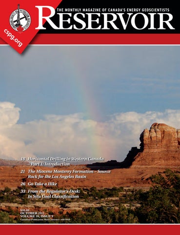
18 Horizontal Drilling in Western Canada – Part 1: Introduction 21 T he Miocene Monterey Formation – Source Rock for the Los Angeles Basin 26 G o Take a Hike 33 F rom the Regulator’s Desk: In Situ Coal Classification $10.00 OCTOBER 2012 VOLUME 39, ISSUE 9 Canadian Publication Mail Contract – 40070050


> GEOSCIENCE SOFTWARE
> CRITICAL INFORMATION
> CONNECTED WORKFLOWS


CONNECTED AT EV ERY TOUCH P OI NT


The IHS suite of geoscience software—which includes IHS Petra®, Kingdom®, LOGarc™ and GeoSyn™—is designed to seamlessly connect to the industry’s leading source of critical Oil & Gas information, eliminating the need to move data manually from source to source and project to project. With this powerful new combination, users can streamline data transfer, enhance database performance and simplify project sharing. The result? Workflows that connect like never before.
Connected workflows mean that IHS customers spend less time looking for data and more time looking for the next big opportunity. It’s just one of the many ways that IHS helps to advance the decisions that advance the Oil & Gas industry.
Find out more at IHS.com/geoscience

Streamline data transfer and simplify project sharing with IHS geoscience software and critical O&G information.
CSPG OFFICE
#110, 333 – 5th Avenue SW Calgary, Alberta, Canada T2P 3B6
Tel: 403-264-5610
Web: www.cspg.org
Office hours: Monday to Friday, 8:30am to 4:00pm
Executive Director: Lis Bjeld
Tel: 403-513-1235, Email: lis.bjeld@cspg.org
Member Services:
Tel: 403-264-5610, Email: membership@cspg.org
Publications and Website: Emma MacPherson
Email: emma.macpherson@cspg.org, Tel: 403-513-1230
Programs Development: Aileen Lozie
Tel: 403-513-1227, Email: aileen.lozie@cspg.org
Database Administrator and Accounting: Kasandra Amaro
Tel: 403-513-1233, Email: kasandra.amaro@cspg.org
Corporate Sponsorship: Lis Bjeld
Tel: 403-513-1235, Email: lis.bjeld@cspg.org
Controller: Eric Tang
Tel: 403-513-1232, Email: eric.tang@cspg.org
EDITORS/AUTHORS
Please submit RESERVOIR articles to the CSPG office. Submission deadline is the 23rd day of the month, two months prior to issue date. (e.g., January 23 for the March issue).
To publish an article, the CSPG requires digital copies of the document. Text should be in Microsoft Word format and illustrations should be in TIFF format at 300 dpi., at final size. For additional information on manuscript preparation, refer to the Guidelines for Authors published in the CSPG Bulletin or contact the editor.
Technical Editors
Ben McKenzie Colin Yeo (Assistant Tech. Editor) Tarheel Exploration Encana Corporation Tel: 403-277-4496 Tel: 403-645-7724
Email: bjmck@live.com Email: colin.yeo@encana.com
Coordinating Editor
Emma MacPherson, Publications Coordinator, CSPG Tel: 403-513-1230, emma.macpherson@cspg.org,
ADVERTISING
Advertising inquiries should be directed to Emma MacPherson, Tel: 403-513-1230 email: emma.macpherson@cspg.org. The deadline to reserve advertising space is the 23rd day of the month, two months prior to issue date.
RESERVOIR ISSUE 9 • OCTOBER 2012 3 OCTOBER 2012 – VOLUME 39, ISSUE 9 ARTICLES Volunteers Needed! .............................................................................................................. 13 2012 – The Wettest CSPG Mixed Golf Tournament Ever 14 Horizontal Drilling in Western Canada – Part 1: Introduction 18 The Miocene Monterey Formation – Source Rock for the Los Angeles Basin 21 Georex – A New Research Symposium at the University of Calgary 24 Go Take a Hike ....................................................................................................................... 26 From the Regulator’s Desk: In Situ Coal Classification .............................................. 29 DEPARTMENTS Executive Comment .......................................................................................................... 5 Technical Luncheons 9 Rock Shop 9, 11, 19, 20
area,
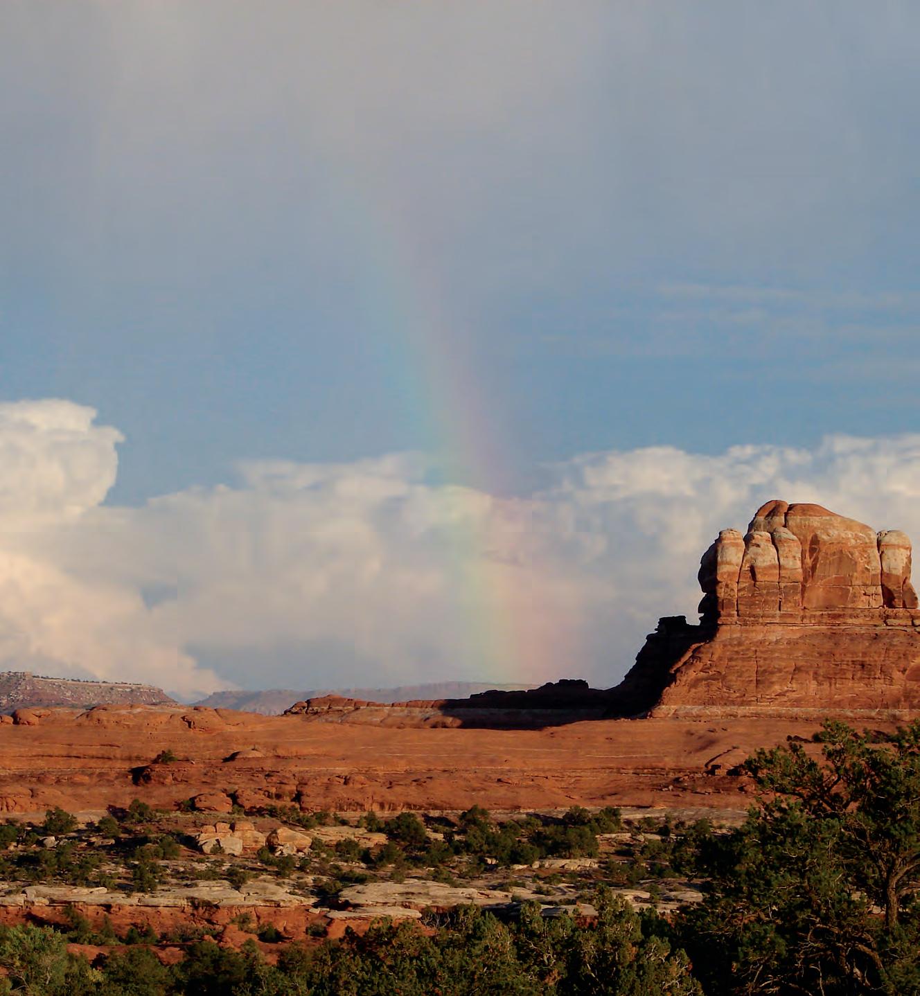
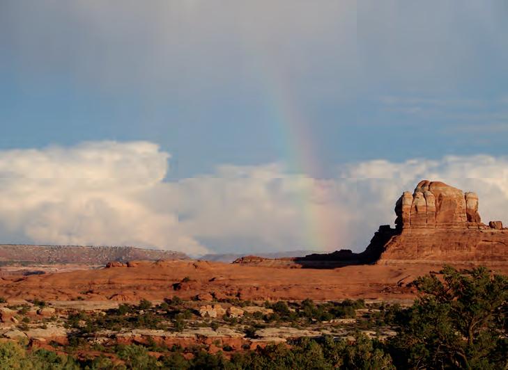
FRONT COVER Canyonlands National Park, Moab
Utah. From top, Jurassic Glen Canyon Group (Kayenta, Wingate formations) is red cliff-former over the Triassic Chinle and Moenkopi and Permian White Rim formations. View east from near Slickrock Trail.
Photo by Gary Prost.
The RESERVOIR is published 11 times per year by the Canadian Society of Petroleum Geologists. This includes a combined issue for the months of July and August. The purpose of the RESERVOIR is to publicize the Society’s
activities
promote
geosciences. We look
both technical
non-technical material to publish. Additional information on
RESERVOIR’s submission guidelines can be found at http://www.cspg. org/publications/pubs-reservoir-submissions.cfm. The contents of this publication may not be reproduced either in part or in full without the consent of the publisher. Additional copies of the RESERVOIR are available at the CSPG office. No official endorsement or sponsorship by the CSPG is implied for any advertisement, insert, or article that appears in the Reservoir unless otherwise noted. All submitted materials are reviewed by the editor. We reserve the right to edit all submissions, including letters to the Editor. Submissions must include your name, address, and membership number (if applicable). The material contained in this publication is intended for informational use only. While reasonable care has been taken, authors and the CSPG make no guarantees that any of the equations, schematics, or devices discussed will perform as expected or that they will give the desired results. Some information contained herein may be inaccurate or may vary from standard measurements. The CSPG expressly disclaims any and all liability for the acts, omissions, or conduct of any third-party user of information contained in this publication. Under no circumstances shall the CSPG and its officers, directors, employees, and agents be liable for any injury, loss, damage, or expense arising in any manner whatsoever from the acts, omissions, or conduct of any third-party user. Designed and Printed by The Data Group of Companies, Calgary, Alberta.
many
and to
the
for
and
the


They can copy us. They just can’t be us. If imitation is the sincerest form of flattery, we’re one flattered group. Drawing on a quarter century of oil and gas experience, geoLOGIC continues to be the market leader in data, software solutions and support. And while we lead the way, our competitors desperately create parity products, sometimes years after us. For details on how geoLOGIC leads the way, visit www.geoLOGIC.com/leader
Leading the way with customer-driven data, integrated software and services for your upstream decision-making needs.
geoSCOUT | gDC | petroCUBE at www.geoLOGIC.com


CSPG EXECUTIVE
President
Robin Mann • AJM Deloitte rcmann@deloitte.ca Tel: (403) 648-3210
Vice President
Paul MacKay • Shale Petroleum Ltd. Paul.Mackay@shalepetroleum.com Tel: (403) 457-3930
Past President
Kirk Osadetz • Geological Survey of Canada, Calgary kosadetz@nrcan.gc.ca Tel: (403) 292-7022
Finance director
Andrea Hood • geoLOGIC systems ltd. ahood@geologic.com Tel: (403) 262-1992
assistant Finance director
Samantha Etherington • CNRL samantha.etherington@cnrl.com Tel: (403) 386-6459
Program director
Jon Noad jonnoad@hotmail.com
assistant Program director
Dave Russum • AJM Deloitte drussum@deloitte.ca Tel: (403) 648-3228
serVices director
Michelle Hawke • Apache Canada Ltd. Michelle.Hawke@apachecorp.com Tel: (403) 261-1200
assistant serVices director
Mike Seifert • Canadian Discovery Ltd. mseifert@canadiandiscovery.com Tel: (403) 269-3644
communications director
Jim Barclay • ConocoPhillips Canada
Jim.E.Barclay@conocophillips.com Tel: (403) 532-3889
assistant communications director
Curtis Evans • ERCB curtis.evans@ercb.ca Tel: (403) 297-8386
outreach director
Simon Haynes • Statoil Canada Ltd. sihay@statoil.com Tel: (403) 724-0364
assistant outreach director
Dawn Hodgins • Imperial Oil Resources dawn.hodgins@exxonmobil.com Tel: (403) 232-5931
executiVe director
Lis Bjeld • CSPG lis.bjeld@cspg.org Tel: (403) 513-1235
EXECUTIVE COMMENT
A message from 2012 Past-President (Kirk Osadetz)
Sharing Our Science: its strengths and its weaknesses
The CSPG is far from being recognized as the home for “Canada’s Energy Geoscientists”. Even in Calgary few people know what the CSPG is or what it does and the mention of acronym “CSPG” in some industrial circles still garners the response, “Who?”. To say this is not good would be an understatement.
Among the CSPG’s strategic goals is our desire to identify a new generation of Petroleum Geologists and to make the public knowledgeable of the CSPG, its members, their work, and their societal contributions. The CSPG Outreach program is our mechanism for creating both public awareness and interest in Petroleum Geology and its associated geosciences.
We have had successes, most notably with the Student Industry Field Trip – since imitation is one of the highest forms of acknowledgement – but also with our other outreach events. Success originates in the passion of our members to stimulate a public awareness and excitement in the Geosciences. Similarly the CSPG’s Outreach program would be impossible without the support of our corporate and individual sponsors, including the CSPG Educational Trust Fund. Thank you to everyone for their contributions.
Every member needs to know the strategic goals of our Outreach program. To these ends the current Outreach Directors Simon Haynes and Dawn Hodgins have conducted a careful and comprehensive analysis of Outreach Programs. As part of their recommendations the Board of Directors has decided to separate Earth Science for Society (ESFS) from the Geoconvention Committee, such that it will become its own separate event, in conjunction with our major ESFS partners.
Much of the CSPG’s Scientific Outreach is focused on children and young adults. The goal is their recruitment into Petroleum Geology. Many CSPG volunteers work diligently to ignite that same sense of excitement that led them to choose careers in the Earth Sciences. Are we successful? Sometimes yes. For example, we know that SIFT participants are more likely to become dedicated and passionate CSPG volunteers compared to the average undergraduate. Yet, we currently have no idea, and, perhaps more importantly, no way of determining if any of the busloads of Calgary students attending Honorary Address or ESFS decide on a scientific career, let alone a Geological one. Based on University and College enrolments we must conclude that the impact of our Outreach activities on education and career are ineffective. Physicians, Dentists, Accountants, and Lawyers do not bus large numbers of young students to similar, let alone multiple, events and yet students compete vigorously to enter these disciplines. If one of our goals is to produce a new generation of Petroleum Geologists, then maybe there are better ways to do it, and certainly better ways to track it.
For all our success, we are not making a significant impact on Societal Decisionmakers. To be honest, they essentially don’t know that we exist. I remember the dismay when, several decades previous, the postal service declined to issue a stamp to commemorate the 50th Anniversary of the Society. Many employers don’t appreciate or underestimate the value that CSPG provides for their employees. For this we can all take some responsibility and as a Past-President I will take a lion’s share. On this front we could certainly do better and future CSPG Executives know that they must.
(Continued on page 7...)
RESERVOIR ISSUE 9 • OCTOBER 2012 5
Want to bring geology back into geophysical interpretation?
All Aboard
Landmark’s new DecisionSpace® Desktop software accelerates seismic interpretation with geomodel-enabled workflows.
The geophysics and geology modules in Landmark’s new unified DecisionSpace® Desktop software share the same topology engine. This gives geophysicists easy access to framework construction tools that combine well picks and horizons to produce a high resolution, accurate geomodel. The geomodel uses conformance technology to produce well-based surfaces at the same resolution as seismic data, enabling a model that truly represents your reservoir. Get better answers faster. Visit halliburton.com/decisionspacedesktop
High Science Simplified®

© 2012 Halliburton. All rights reserved.
CORPORATE SPONSORS
DIAMOND
CENOVUS ENERGY
GEOLOGIC SYSTEMS LTD.
POGGENPOHL
PLATINUM
IMPERIAL OIL LTD.
NEXEN INC.
SCHLUMBERGER CANADA LIMITED
SHELL CANADA LIMITED
GOLD
APEGA
DEVON ENERGY CORP
ENCANA CORPORATION
SILVER
ATHABASCA OIL SANDS CORPORATION
CSEG FOUNDATION
CSPG ETF
ENERPLUS
IHS
JEWELSUITE
LED SIGNS
ROKE TECHNOLOGIES LTD.
RPS
SENSOR GEOPHYSICAL LTD.
TAQA NORTH LTD.
BRONZE
BLUEBACK RESERVOIR
EARTH SIGNAL PROCESSING LTD.
GEOSTRATA
GEOVARIANCES
GLJ PETROLEUM CONSULTANTS LTD.
HUSKY ENERGY INC.
PARADIGM
SUNCOR
TALISMAN ENERGY
TUCKER ENERGY SERVICES
AS OF SEPTEMBER 10, 2012
A SPECIAL THANKS TO GEOLOGIC SYSTEMS LTD., CSPG’S TOP SPONSOR OF THE MONTH
(...Continued from page 5)
Our Outreach program is simultaneously both a noble cause and a major expenditure. While some activities, like the Honorary Address, have modest participation revenues most of the cash flow is outward. It is therefore, appropriate to examine our Outreach activities and to direct them strategically. Could we hope for a better result for what we spend? Of course we could and it is a goal that all of us need to embrace if we are to succeed. We also have to develop measurements of its success against those goals rather than keeping count of participants. We should bring the same diligent and effective practice to our volunteer work that we use in our professional careers.
Are we using our reputation as the most successful geoscience society in Canada to our benefit and are we maintaining that reputation? Much of the CSPG’s reputation was established using a specific business model. Thematic convention sessions or research conferences attracted leading presenters, large audiences, and new concepts. In the past it was common for the results and proceedings of these sessions to produce peer-reviewed monographic publications, for example:
• t he Geological Atlas of the Western Canada Sedimentary Basin;
• t he proceedings of the International Devonian Symposia, Memoir 15 Sequences, Stratigraphy, Sedimentology; and
• S urface and Subsurface and Thematic issues of the Bulletin of Canadian Petroleum Geology such as the “Triangle Zone and Tectonic Wedges” volume 44, number 2.
More than anything it was these publications that garnered international recognition and delivered global impact to the CSPG and its members. It was also a profitable business model for the Society. Happily this tradition has resumed. A forthcoming thematic issue of the Bulletin will contain papers first presented at the 3rd Resource Assessment Workshop that was held in Canmore (2010), while the organizers of the 2011 CSPG Gussow Research Conference “Advances in Applied
Geomodeling for Hydrocarbon Reservoirs: Closing the Gap” will re-start the Memoir series after a long hiatus.
Yet our publications continue to struggle. The Reservoir is looking for authors of technical articles and series. The Bulletin of Canadian Petroleum Geology needs contributions. Everyone should know that our BCPG is now as accessible and prominent as the AAPG Bulletin because of their joint listing on the Geoscienceworld search engine (http://www.geoscienceworld.org/). But most of all the Society needs young leaders who will convene the research conferences and convention sessions that will produce future papers, special publications, and memoirs that will be both a service to the membership and a distinguishing feature in successful personal careers. So, consider the possibilities, think positively and energetically, and use the mechanisms of the Society to further the goals of the society and your own career as a session convenor, a conference organizer, a memoir editor, or as a scientific author.
Surely the commitment we have to public outreach can be matched by a commitment to make the CSPG known as the premier regional geoscience society worldwide. It was a position we once held and it is a goal that is easily within our grasp.
If you are interested in increasing your involvement with the CSPG, please stop by and introduce yourself. We are on the street level at 333 5th Avenue SW, Calgary, AB.
RESERVOIR ISSUE 9 • OCTOBER 2012 7
Five Great Days of the Finest Geoscience Training for One Low Price
List of Topics:
• Risk and Uncertainty for Contemporary Prospect Evaluation
• Asset Management in Unconventional Plays
• Geocellular Modeling in Unconventional Resources
• Carbonate Seismic Sequence Stratigraphy
• Carbonate Depositional Systems
• Quick Guide to Carbonate Well Log Analysis
• Seismic Amplitude Interpretation
• Principles and Applications of Well Logging
• Formation Evaluation of Thinly-bedded Reservoirs
• “Old” (Pre-1958) Electric Logs: A Quick Review …and more to come!
(Four concurrent sessions each day – mix and match according to your interests and training needs. Buffet lunch and refreshments included each day.)
Small AAPG Bookstore open during breaks each day
Tuition for
(Your five-day badge can be transferred to a friend or colleague if you can't attend all five days.)
Hosted by the Norris Conference Center: 803 Town & Country Lane Houston, TX 77024
Phone: 713-590-0950
Fax: 713-590-0961
Special group rate at nearby Hotel Sorella
Registration and information:
Toll-free (U.S. and Canada) 888-338-3387, or 918-560-2650
Fax: 918-560-2678
E-mail: educate@aapg.org
Download a registration form at: www.aapg.org/education/wec.cfm
8 RESERVOIR ISSUE 9 • OCTOBER 2012
the week: AAPG Members..........................$1795 $1895 Non Members............................$1895 $1995 Individual Courses....................$475/day $525/day
SIGN UP NOW!
BY BECOMING AN AAPG MEMBER AND REGISTERING BEFORE JAN. 16 th 10 th ANNUAL HOUSTON, TX • FEBRUARY 11-15, 2013 Price increase after 1/16/2013 Price through 1/16/2013 SAVE $ 200
WINTER EDU CATION CONFERENCE
technicaL Luncheons OCTOBER LUNCHEON
The Tagish Lake meteorite: clues to ‘maturation’ of organic matter in the early solar system
SPEAKER
Dr. Chris Herd
Smithsonian Institution’s National Museum of Natural History
11:30 am
tu esday, o c tober 9, 2012 te Lu s convention centre c algary, a l berta
Please note: the cut-off date for ticket sales is 1:00 pm, monday, october 1, 2012. csPg member ticket Price: $42.00 + gst non- member ticket Price: $45.00 + gst
ROCK SHOP
Each CSPG Technical Luncheon is 1 APEGA PDH credit. Tickets may be purchased online at www.cspg.org.
The complex suite of organic materials in carbonaceous chondrite meteorites probably originally formed in interstellar space and/or the solar protoplanetary disk, but was subsequently modified in the meteorites’ asteroidal parent bodies. The mechanisms of formation and modification are still very poorly understood. We carried out a systematic study of variations in the mineralogy, petrology, and soluble and insoluble organic matter in distinct fragments of the Tagish Lake meteorite. The circumstances of this meteorite’s fall and recovery enable new insights into preterrestrial organic matter variability. The variations correlate with indicators of parent body aqueous alteration, and at least some molecules of importance for life on Earth formed during the alteration.
BIOGRAPHY
Dr. Chris Herd is a geologist whose interests are many and varied, and best described under the


Webcasts sponsored by

heading of comparative planetology. He has a fascination with the origin and geologic evolution of planets in the solar system. Dr. Herd completed his undergraduate degree in Geological Sciences at Queen’s University in 1997. His interest in working on meteorites from Mars took him to the University of New Mexico in Albuquerque for his Ph.D., which was fully funded by a NASA graduate fellowship. In 2001 he moved to the Lunar and Planetary Institute in Houston, where he worked as a postdoctoral fellow with access to the facilities at the Johnson Space Center. He was hired in July of 2003 at the University of Alberta as assistant professor in the Department of Earth and Atmospheric Sciences, and was awarded tenure in July 2008. He teaches Mineralogy and Planetary Geology for the Geology program, and is the curator responsible for the Alberta Meteorite Collection, the largest University-based meteorite collection in Canada. In 2006, he led the consortium purchase of the pristine specimens of the organic-rich Tagish Lake meteorite. He recently returned from a year-long sabbatical at the Smithsonian Institution’s National Museum of Natural History in Washington, D.C., and is now supervising the construction of a unique facility for the curation of pristine meteorites.


1602 – 5th St N.E. Calgary, AB T2E 7W3 Phone: 403-233-7729 www.tihconsulting.com e-mail: tih@shaw.ca T.I.H. Consulting Ltd. Geologic Well-Site Supervision • Domestic and International wellsite supervision • Conventional and Unconventional wells • Extensive Hz experience • Customized corporate solutions available (403) 250-3982 sales@clconsultants.ca www.clconsultants.ca *Domestic & International Supervision 906, 505 6 St. SW Calgary, AB T2P-1X5 Jocelyn Lampron, P. Geol. President & CEO Wellsite Geological Supervision *Conventional Wells-Heavy Oil/SAGD *Coal Bed Methane Wells www.hopewellpetroleum.com info@hopewellpetroleum.com CD N BA CD BA n yevr 234 765 101112 15 8 9 16 1413 23456 11 10987 1716151413 2322212019 2627282930 35 12 18 24 25 36 34333231 section lsd township ph: 403.266.3132 cell: 403.818.8549 *On & Offshore Geological Supervision
technicaL Luncheons OCTOBER LUNCHEON
An Arctic perspective on 20th century warming
SPEAKER
Gifford Miller
University of Colorado, Boulder, CO
11:30 am
tuesday, o c tober 23
t e L u s c onvention c en tre c al gary, a l berta
Please note: the cut-off date for ticket sales is 1:00 pm, Wednesday, october 17, 2012. csPg member ticket Price: $42.00 + gst. non-member ticket Price: $45.00 + gst.
Each CSPG Technical Luncheon is 1 APEGA PDH credit. Tickets may be purchased online at www.cspg.org.
Over the past century our planet has warmed about 1.5°F. We know this from thermometers that have recorded temperatures around the planet. It is a fact. The more interesting questions are “Why?” and “Is the warming part of a natural cycle, or related to something we humans are doing?” The planet has been hotter and colder in the past, can this be just part of a longer climate cycle? Despite being remote and inhabited by few people, the Arctic is an ideal region to try to answer these key questions because temperature changes are always larger in the Arctic than elsewhere in the Northern Hemisphere. This is because of the strong positive feedbacks from snow, plants, and sea ice, resulting in a signal much larger and clearer in the Arctic than elsewhere. A little-noticed Arctic study by a Canadian geographer in the 1960s demonstrated that some ice caps preserve rooted tundra plants that are revealed as the ice margin recedes. We have capitalized on this observation to derive an extensive database of vegetation “kill dates” from which we can place the current warming in a millennial perspective and help to explain the occurrence of severe climate perturbations such as the Little Ice Age (1300-1850 AD). I will review how studies in the Arctic help to place the warmth of the past century in a longer-term perspective to try to
Webcasts sponsored by
get a better understanding of what this warming means.
BIOGRAPHY
Gifford Miller, Ph.D.
Professor of Geological Sciences and Fellow, Institute of Arctic and Alpine Research (INSTAAR), University of Colorado at Boulder. Director, Center for Geochemical Analysis of the Global Environment (GAGE).
As a Quaternary Geologist, Gifford focuses his research on reconstructing the behavior of the climate system in the recent past as a means of improving our understanding of natural climate variability. He has conducted extensive field campaigns in the Eastern Canadian Arctic, Iceland, and Svalbard that focus in reconstructing past environmental change and deriving inferences about the associated climates that lead to those changes. He has also had an active field program in Australia for more than 20 years, where he is studying the impacts of human colonization
on a continent that never had humans, or even placental mammals. Gifford was elected a Fellow of the American Geophysical Union and the Geological Society of America, where he was recipient of the Easterbrook Distinguished Scientist Award. He is also a Foreign Member of the Norwegian Academy of Science and Letters.
10 RESERVOIR ISSUE 9 • OCTOBER 2012
technicaL Luncheons NOVEMBER LUNCHEON
Carbonates –A challenge for basin modelers
SPEAKER
Marek Kacewicz
AAPG Distinguished Lecture
11:30 am
tuesday, november 13, 2012
teLus convention centre calgary, alberta
Please note: the cut-off date for ticket sales is 1:00 pm, thursday, november 8th, 2012. csPg member ticket Price: $42.00 + gst. non-member ticket Price: $45.00 + gst.
Each CSPG Technical Luncheon is 1 APEGA PDH credit. Tickets may be purchased online at www. cspg.org.
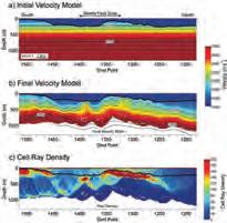
Our understanding of facies and internal connectivity within carbonate platforms is often inadequate despite the fact that carbonate petroleum systems are widespread throughout the world, account for approximately 50% of world hydrocarbon reserves, and have been heavily studied for many years. Petroleum systems modeling routinely used in exploration allows testing different facies distribution / connectivity scenarios and contributes to a better understanding of key uncertainties and reduction of exploration risk. However, if misused or based on insufficient input data, petroleum systems models may generate
ROCK SHOP
misleading results and lead to drilling unnecessary dry holes. This is especially true if the resolution of the model is too low or calibration data is sparse.
Regional-scale petroleum systems models of carbonates often miss the critical details such as platform geometry, facies distribution within a platform, and high resolution rock flow/seal properties that are required for a proper evaluation of hydrocarbon migration, prediction of pre-drill pressure and estimation of accumulated hydrocarbons. In addition, they typically don’t address syn- and postdepositional factors such as diagenesis and stress history.
For the purpose of this study, a synthetic carbonate platform was built to demonstrate typical problems associated with modeling carbonate petroleum systems and for testing potential hydrocarbon migration and trapping scenarios. It allows simulating petroleum systems that are similar to the Arab and Khuff formations in the Middle East, isolated platforms in Kazakhstan, and others. This presentation will discuss petroleum systems modeling methodology and guide the audience through different low- vs. high-resolution scenarios leading to dramatically different exploration implications.
B IO GRAPHY
R esearch Consultant and Basin Modeler Chevron Energy Technology Company, Houston. Funded by the AAPG Foundation J. Ben Carsey Endowment.


Webcasts sponsored by
Marek Kacewicz is research consultant and basin modeler at Chevron Energy Technology Company in Houston, Texas. His primary responsibilities include research and technology applications integrating petroleum systems modeling, seismic inversion, velocity modeling, pressure prediction, geomechanics, and structural modeling.
Prior to Chevron, Marek worked as a research geologist at ARCO Exploration and Production Research Center in Plano (Texas, USA), as a basin modeler at Unocal Exploration & Exploitation Technology in Sugar Land in Houston (Texas, USA), Alexander von Humboldt Fellow at the Freie Universitaet Berlin (Berlin, Germany), and Research Assistant at the University of Warsaw (Warsaw, Poland). Marek has over 20 years of experience in petroleum systems modeling, exploration, and research.
His experience includes both conventional and unconventional resources and covers a wide range of sedimentary basins worldwide. Some of Marek’s professional honors include receiving the 1986 International Association for Mathematical Geology Vistelius Research Award, being selected for the Alexander von Humboldt Fellowship (Germany), and receiving the 2005 AAPG Gabriel Dengo Memorial award.
Kacewicz has an M.S. degree in Numerical Mathematics / Computer Science and a Ph.D. in Earth Sciences, both from the University of Warsaw (Poland).
RESERVOIR ISSUE 9 • OCTOBER 2012 11
Conventional Vertical and Horizontal Wells Oil Sands - SAGD/Coring Programs Shale Gas/Oil Shales Coal Bed Methane Project Supervision Email: progeo@telus.net Tel: (403) 262-9229 Fax: (403) 265-0377 Website: www.progeoconsultants.com petrographical & sedimentological descriptions for samples (thin section - fluid inclusion studies) conventional vertical/horizontal wells operations geology SPECIALIZED IN GEOLOGICAL WELLSITE SUPERVISION AND CORE ANALYSIS RockWell Consulting our best friend and most valuable partner is our client Stephan C. Dragomir president www .g e ok2. c om - phon e: 403.831.9941 - s dr a gomir @ge ok2. com
Introducing Paradigm Geolog 7
NEXT-GENERATION FORMATION EVALUATION
For close to thirty years, Geolog® has been recognized as the standard for integrated well bore data management, petrophysical analysis, and formation evaluation. Geolog’s rich history of innovation and practical application development has empowered companies to assess the economic viability of potential and proven fields with increased confidence.
Geolog 7 continues its tradition of industry leadership by providing users with a fresh look and style for improved user efficiency, usability enhancements, and new application features. Together, they help you refine models quickly and easily and extract maximum value from existing data, resulting in higher performance and lower drilling costs.
Independence
• You control the outcome: processing from raw data to finished interpretation
• Freedom to use your preferred logging vendor
• Direct links to third party well data stores
Efficiency
• Customize interface and workflows with tools that others can’t offer
• The only system that can manage large scale well projects faster and easier
• Perform multi-well petrophysical analysis with fast, one click operations
• Fast Data loading through “drag and drop” interface
• Track every curve – every well using Geolog’s comprehensive audit trail tools
Science
• 30 years of user driven innovation at your fingertips
• The only model-based Monte Carlo uncertainy analysis for complete understanding of hydrocarbon reserves
• Rigorous validation of reserves with new, interactive core analysis and saturation height modeling
• Integrated real time geosteering for real time answers

Be a part of user-driven innovation. Join the Geolog User Group on LinkedIn. http://linkd.in/Geolog.
12 RESERVOIR ISSUE 9 • OCTOBER 2012
VOLUNTEERS WANTED!
CSPG is recruiting volunteers for the following positions:
Student i n dustry Field tr ip (S i F t ) Committee Chair
The SIFT experience is a once in a lifetime opportunity offering an intense, informative and interactive two-week-long adventure for select students across Canada. SIFT is looking for a chair to be responsible for leading the committee through planning, budgeting and implementing the trip. Candidate must have more than five years’ experience working in the Oil and Gas industry.
University Scholarship Selection Committee Chair
A new program that provides two student scholarships, per province, yearly. A chair is needed to get the committee up and running, solicit universities for candidates, and choose recipients.
Honorary a d dress Committee Chair
The Honorary Address is an annual event held in late fall giving the general public an exposure to the geosciences through an evening speaker session. A committee chair is needed to lead the committee through budgeting, planning and implementing, and evaluating this yearly event.
Gussow Geoscience Conference Committee Chair
The Gussow Geoscience Conference is an annual conference held in Banff, AB (subject to change) in late fall. It is an intimate and specialized conference with themes changing yearly. A committee chair is required to oversee the yearly events: choosing upcoming themes, conference chairs, and putting together a committee to ensure the success of the conference.
Graduate t h esis awa rd Committee vol unteer
The Graduate Thesis Award Committee evaluates potential theses to award the CSPG Ph.D. and M.Sc. Graduate Thesis Awards. Committee members should have
an advanced degree (M.Sc. or Ph.D.), a willingness to read, a critical eye, and an open mind. Award recipients are chosen in late fall yearly.
Medal of Merit aw ard Committee
The Medal of Merit Award is awarded annually for the best paper on a subject related to the petroleum geology of
Canada. Two more members are needed to fill the committee. Volunteers must have at least five years of industry experience, an M.Sc. or Ph.D., and expertise in structural geology or unconventional plays.
To apply for any position, please contact Kasandra.Amaro@cspg.org or 403-513-1233.


RESERVOIR ISSUE 9 • OCTOBER 2012 13
QualityMulti-client Data
2012 - T H E W E TTEST CSPG M I XED G OLF T OURNAMENT E V ER
| By David Middleton
What do you call three weeks of hot, dry summer weather followed by a day of rain, temperatures of 6°C and strong winds – the 23rd Annual CSPG Mixed Golf tournament! The “mixed” in the tournament name has always referred to the mixing of all levels of golfer in the annual scramble tournament, and not the unusual weather patterns we experienced on Friday, August 24th at Lynx Ridge Golf course after what had been glorious golfing weather previously.
The CSPG members, sponsors, and guests teed off at 8:00 am in the rain, and the 124 golfers finished the day in the sunshine. The Lynx Ridge course was in great shape, and although the tee shots suffered in distance from the water on the fairways, the best ball tournament concluded in a little over five hours.
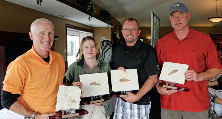
The team low-net trophy and tournament winners, with a net score of 58, was captained by Tim Bergan, and consisted of Andy Marven, Murray Yewchuk, and Jennifer Kingsbury. The low-gross-score trophy was taken by the team of Daniel Gee, Patrick Biss, Derek Mawbey, and Maren Blair with a score of 64, and the less-coveted fossil coprolite trophy went to the most-honest team of Roy Smith, Ken Titchkosky, Pamela Brown, and Kurt Armbruster with a score of 79.
The 23rd annual tournament was sponsored by our Platinum-level sponsor, IHS, as well as numerous other sponsors. All teams enjoyed a hot breakfast provided by Exova; warm-up shots on the Rigsat Communications driving range; used golf carts sponsored by CL Consultants; and visited hospitality tents provided by IHS, Cougar Consultants/Roke Technologies, BrokerLink, Sensor Geophysical, Energy Navigator, AGAT Laboratories, and MJ Systems. We had holes sponsored by
(Continued on page 14...)
14 RESERVOIR ISSUE 9 • OCTOBER 2012
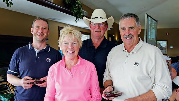
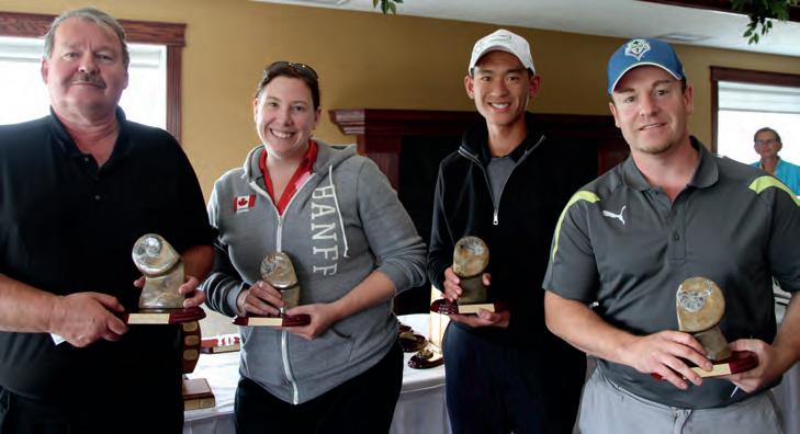
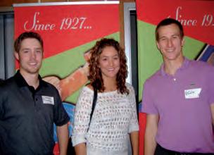
2012 High-Gross Team.
2012 Low-Gross Team.
2012 Low-Net Team Winners.
23rd Annual CSPG Mixed Golf


RESERVOIR ISSUE 9 • OCTOBER 2012 15
P L A T I N U M S P O N S O R G O L D S P O N S O R S H O L E S P O N S O R S S I L V E R S P O N S O R S P r i z e D o n o r s Mcleay Geological Total Gas RBC Dominion Securities Typhoon Energy Genesis Executive RPS Energy
Tournament Thank you to our valuable sponsors!
GLJ Petroleum Consultants
Belloy Petroleum Consulting, RPS Energy, Sproule Associates, Core Laboratories, ProGeo Consultants, Birchcliff Energy, TOTAL Gas Detection, and BDO Canada LLP. The on-course beverage cart was sponsored by geoLOGIC Systems, and a lot of coffee and Bailey’s was consumed by wet and cold golfers. At the tournament finish, golfers participated in the Tucker Energy Services Putting Contest, where the winner, Michael Clegg with two successful putts, took home a new 50” flatscreen TV.
The delicious banquet steak dinner was sponsored by GLJ Petroleum Consultants while golfers watched for their team scores and photos on the scoring system sponsored by Schlumberger. Dinner was followed with the awarding of team trophies for Low Net, Low Gross, and High Gross, and the announcement of draw prizes. A lucky Dick Willott took home a new IPAD from the Mulligan draw, while Armin Schafer was the beneficiary of the 50/50 draw. Skill
prizes were awarded to golfers, and with the prize donations from Typhoon Energy, RBC Securities, McLeay Geological, Total Gas Detection, Exova, RPS Energy, Sigma Explorations, and Genesis Executive, many of the golfers went home with a nice prize, along with the bragging rights of playing in the wettest CSPG golf tournament in recent memory (at least since a certain member accidentally drove a cart into a water hazard years ago!).
In the end, the members, guests, sponsor players, and representatives enjoyed a great day catching up with colleagues, making new friends, bragging about the missed puts and closest to the pin opportunities, and succeeded in raising almost $5,000 to support the educational and outreach activities of the CSPG.
I would like to thank the many sponsors; golfers; the greens-keeping, pro shop, and catering team at Lynx Ridge Golf course; and especially the committee of co-chairs
Brenda Pearson, Darin Brazel, and Armin Schafer on sponsorship; Norm Hopkins (trophies); Penny Christensen (prizes); and Jeff Boissonneault (signage).
We look forward to your attendance at next year’s tournament on Friday, 23 August 2013. Please watch the CSPG Website for more pictures and results.
David Middleton and Brenda Pearson 2012 co-chairs, CSPG Mixed Golf Committee
CALLING ALL YOUNG GEOLOGISTS!
CONNECT and NETWORK with your peers, future employers, and CSPG volunteers, and learn how CSPG’s services and technical development programs can aide your professional development
Date: Thursday, October 18, 2012
Location: West Restaurant & Bar
Time: 4:30pm – 8:00pm
Appetizers and beverage ticket included….. FREE Register online at www.cspg.org (limited spots available)


16 RESERVOIR ISSUE 9 • OCTOBER 2012
CALLING ALL YOUNG GEOLOGISTS!
(...Continued from page 14 )
STANLEY SLIPPER MEDAL
CALL FOR NOMINATIONS
“This pioneer and explorer in geology, engineering and natural gas technology bequeathed a fundamental knowledge, years ahead of his time and was considered by many a virtual Leonardo da Vinci of the Petroleum Industry. Slipper, our First President, deserved the honour (unbeknownst to him) of our highest award in the Canadian Society of Petroleum Geologists” (Aubrey Kerr).
The Stanley Slipper Medal is the CSPG’s highest honour.
The gold medal is presented annually by CSPG for outstanding contributions to oil and gas exploration in Canada. The contributions of the winner of this award should encompass a number of activities related to aspects of petroleum exploration. Such activities include: initiating and/or leading exploration programs, significant discoveries on new or existing exploration trends, teaching and/or training of explorationists, and involvement in and leadership within geological societies and professional organizations.
The committee is currently calling on the CSPG membership to provide additional nominations for this prestigious award. The award winner must be a CSPG member and should be able to attend the awards presentation to be held in the spring of 2013.
Please include an updated bibliography and letters in support of your nominee.
Nominations should be mailed, faxed, or emailed before October 15 to:
CSPG Stanley Slipper Committee – Clint Tippett
110, 333 – 5 Ave SW Calgary, AB T2P 3B6
Email: clinton.tippett@shell.com and membership@cspg.org
Phone: 403-264-5610 Fax: 403-264-5898
RESERVOIR ISSUE 9 • OCTOBER 2012 17
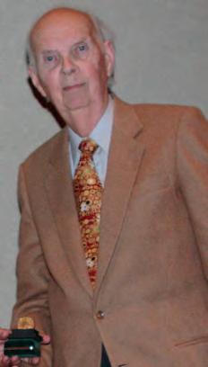
2011 Stanley Slipper Recipient Ned Gilbert
Stanley Slipper Medal
HORI z ONTAL DR ILLING IN W E STERN C A NADA – Part 1: Introduction
| By Dave Russum, Director Geoscience, AJM Deloitte
The dual technologies of horizontal drilling and multi-staged fracturing have created a revolution in oil and gas production in North America that is rapidly spreading to other parts of the World. Canada has played a big role in the evolution and application of this technology.
Horizontal drilling became a reality in the late 1980s with arguably the first drilling of horizontal wells for conventional oil in Western Canada occurring in 1987 – making this year the twenty-fifth anniversary – and an appropriate time to take a look back on this technology. This paper is the first of a series of articles that will look at the impact of this activity in the Canadian oil and gas industry.
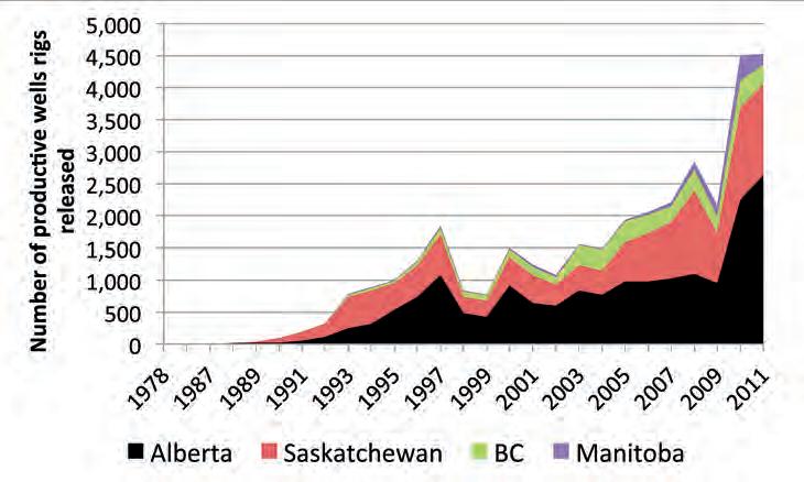
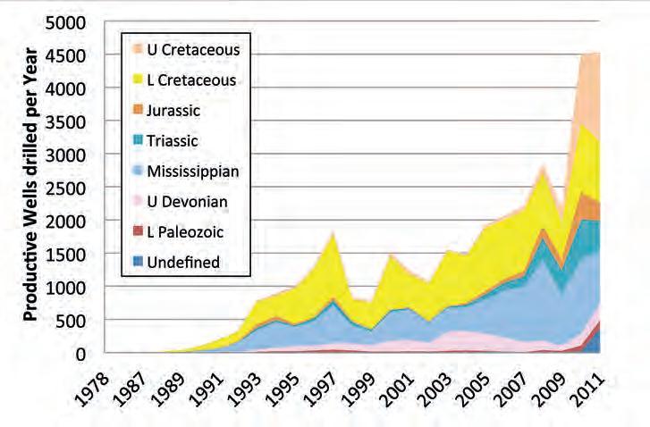
The data for this study was extracted from a GeoScout search in March 2012; Figure 1 would suggest that 2011 activity was virtually identical to that in 2010 with 4,500 productive completions. However, delays in bringing wells on production following late 2011 drilling will mean that 2011 is truly the most active year ever for horizontal drilling. As at the end of 2011, over 35,000 productive horizontal wells have been drilled in Western Canada.
This study has also focussed solely on wells classified as ‘horizontal’; during the study it became obvious that a large number of wells are classified as ‘deviated’, despite having considerable horizontal displacement, some
of these wells probably should be included in this study.
Figure 1 shows early horizontal activity dominated by Saskatchewan with Alberta moving ahead in 1995. Alberta activity stagnated during Alberta’s misguided attempts to raise royalty rates (2007-2008) while Saskatchewan activity continued to grow. Resolution of the royalty dispute saw
Alberta’s activity accelerate in the 2009 to 2011 period. Manitoba’s contribution has grown exponentially since 2009 due to various opportunities to exploit light oil in low-permeability reservoirs.
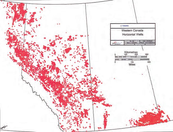
Figure 2 shows the distribution of all horizontal wells in Western Canada, illustrating that the technology has been used in all areas of the western Provinces from northeastern British Columbia to southwestern Manitoba.
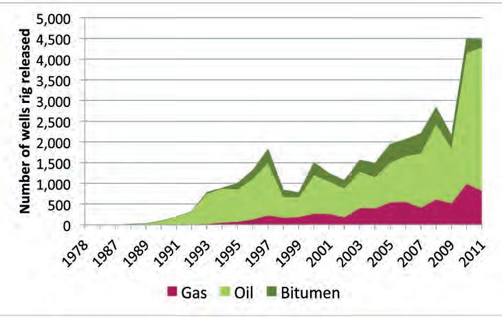
Early activity was directed to extracting more oil from lower-quality conventional oil reservoirs (Figure 3). Modest activity in gas and bitumen plays grew steadily. Conventional oil activity collapsed in 1998 when oil prices dropped to $10 per barrel and did not return to 1997 levels until nearly ten years later.
Fracturing of horizontal wells had always been a tool for enhancing productivity; but it was not until 2003 that industry began to perfect the ability to place artificial fractures in specific zones within a horizontal well and significantly increase initial production. The steady evolution of this technology has culminated in very sophisticated multiplestage fracturing techniques that may double
18 RESERVOIR ISSUE 9 • OCTOBER 2012
Figure 1. Productive horizontal wells by year of rig release for each of the western Provinces.
Figure 2. Distribution of horizontal wells in the Western Canada Sedimentary Basin.
ROCK SHOP

Reservoir Geomodeling Reservoir Simulation Integrated Study
Julee Lee (403) 554-3957, Helen Cao (403) 968-6268, Gary Selby (403) 818-1594 jlee@petrosteer com, hcao@petrosteer com, gselby@petrosteer com
the cost of a well but allow extraction from reservoirs that previously would have been ignored.
Oil price continued to encourage oil drilling through to the end of this study with a brief pause during the global recession of 2008. Gas drilling meanwhile showed steady growth with the high prices of the first half of the first decade of the Millennium first directed to the Jean Marie in northeastern British Columbia and later dominated by development of the Montney. With falling gas prices due to a glut of production in the United States, industry moved aggressively into liquids-rich gas, which has propped up the gas-drilling statistics but created a further glut in both gas and liquids that continue to put downward pressure on prices in a fragile economy.
Figure 4 shows the early focus of horizontal drilling on Lower Cretaceous and Mississippian plays. Over time, the activity has expanded to cover virtually every formation from surface to basement across the Western Canada Sedimentary Basin. Undefined wells are typically recently drilled wells that are still under a confidential status.
The second article in this series will look in more detail at the early history of horizontal drilling and the technological breakthroughs that helped make this activity viable. As part of this series, I intend to incorporate the impact that this technology has had on the business of wellsite geology. I would welcome either an article or reminiscences from somebody in the wellsite geology community. Please contact me at drussum@ deloitte.ca.
CRAIN’S LOG ANALYSIS COURSES
For Engineers, Geologists,
Individual, Corporate, and Academic Licenses Available === E. R. (Ross) Crain. P.Eng. 1-403-845-2527 ross@spec2000.net === – 50 Years Worldwide Experience – Analysis, Training, Mentoring, Forensic Reviews –===
RESERVOIR ISSUE 9 • OCTOBER 2012 19
Figure 3. Distribution of productive horizontal wells by product.
Figure 4. Distribution of productive horizontal wells by Epoch.
Geophysicists, and Technicians Narrated Multi-Media Audio-Visual Slide Shows for Self Study AV-01 Practical Quantitative Log Analysis AV-02 Advanced Quantitative Log Analysis AV-03 Analysis of Unconventional Reservoirs Details at:
www.spec2000.net/00-courseware.htm
油田投资项目咨询 油田收购评估 油气田勘探开发技术支持
www.petrosteer.com 贝 特 斯 亚 海 外 石 油 研 究 中 心
ROCK SHOP


20 RESERVOIR ISSUE 9 • OCTOBER 2012 Strip Log Strip Log Horizontal Log Horizontal Log Mud Log Mud Log Log Viewer Log Viewer Log Manager Log Manager Log Analysis Log Analysis Suite 102, 7370 Sierra Morena Blvd SW, Calgary, AB T3H 4H9 info@WellSight.com 1-800-447-1534 (403) 237-9189
Excellence in Geological Services for Over 20 Years Integrated Reservoir Studies for All Resource Types 4D Geomodelling & Geosteering Horizontal Well Path Planning Infill Well Placement Studies SMART4D Modelling ® Software www.uogc.com 403.265.0111 91 0 , 396 11th Ave SW C a lgar y, AB Cana da Conventional Wells • Horizontal Wells - Spearfish - Viking - Bakken - Cardium - Horn River Shale Gas Email: afran@telusplanet.net www.serpaconsulting.com SABLEPETROLEUM CONSULTANTSINC. WELLSITE GEOLOGICAL SUPERVISION FARHAT HYDERI,P.Geol. President / CEO 3300, 205 - 5th Ave SW Calgary, AB T2P 2V7 Tel403 726 0666 Fax403 264 1262 Cell403 819 2516 farhat@sableconsultants.com SABLECONSULTANTS.COM Conventional Wells Coring Programs Heavy Oil/Oil Sands Coal Bed Methane SAGD Horizontal Project Supervision www.rpsgroup.com/energy (403)263-0449 17084 Global Leaders in Wellsite Geology Serving the petroleum industry for over 25 years ■■ Conventional Vertical / Horizontal Wells ■■ Unconventional Heavy Oil / CBM Wells ■■ International WSG / Operations Geology
T H E M IOCENE MONTEREY FORMATION
– Source Rock for the Los Angeles Basin
| By Anne Hargreaves
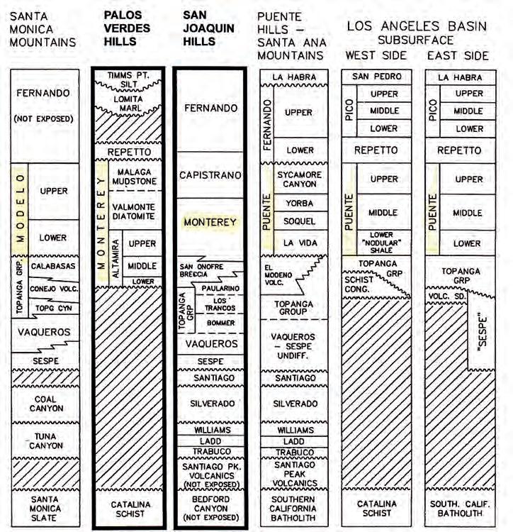
The Monterey Formation is a bio-siliceous, very organic-rich deposit found in southern California. It was deposited between 17 – 5 Ma during a time when tectonic forces were shifting, and localized subsidence during a time of high eustatic sea level, along with coastal upwelling, affected the area. The Monterey and its equivalents (Figure 1), the Puente and the Modelo formations, are the primary source rocks for oil production in the Los Angeles Basin.
The geological history of California is quite complex. However, an effort to sum it up is as follows: 200 million years ago, the western edge of North America was approximately at the current border of California and Nevada. Then, as the mid-Atlantic Ridge began to spread, North America began to move west colliding with the floor of the Pacific Ocean, which was subducted beneath it. The overlying oceanic sediments and volcanic
islands crumpled into the North American continent, eventually becoming California.
This happened in three main events. The first one, during the Mississippian, was the Antler orogeny, which created the Shoo Fly metamorphic complex – now part of the eastern Sierra Nevada. The Shoo Fly complex became the ‘new’ west coast. Next, when the mid-Atlantic Ridge began to separate in earnest at the end of the Triassic, the new coastal deposits shed off the Shoo Fly were compressed and accreted onto the continent, becoming the Calveras complex. This is now a central range in the Sierra Nevada. At the same time, an old volcanic island arc was included in the accreted mix, becoming the Western Jurassic Terrane. The third important event occurred in early Cretaceous time when the subduction zone jumped west by 60 km for an unknown reason, creating an inland sea over what
was to become the Great Valley. Also at this time, a chunk of the Sierra Nevada detached and moved west becoming the Klamath Mountains of northern California. A new trench began to form offshore; the Franciscan Trench, which collected sediment during the Cretaceous until the Oligocene. At that time, general uplift created the Coast Range on the newest west coast, and the broad expanse of the Great Valley, now an inland sea, continued to fill with sediments.
In the middle of the Miocene about 17 million years ago, a lot of volcanic activity in Oregon resulted in massive flood basalt flows over that state and in California. One theory for this massive basalt flow is that a massive meteorite hit SE Oregon, allowing more than 100 cubic miles of lava easy access to the surface through the resulting fractures.
At this time, the San Andreas Fault came into its own. The San Andreas strike-slip fault (SAF) occurs at the juncture between the Pacific plate and the North American plate. Currently the Pacific plate moves northward at a rate of 2 inches per year and to date has carried California west of the fault northward at least 350 miles.
Meanwhile, at this time, the Basin and Range areas east of the SAF, began to form due to crustal tension and stretching. This province consists of isolated mountain ranges separated by desert plains. It is estimated that this area has widened and thinned, and is currently twice as wide as it was before the great event that initiated this action around 17 million years ago.
Lastly, at this time, the Coastal Ranges began to uplift. As the Coastal Ranges began to rise, the deposition of the Monterey Formation commenced.
Thanks to a field trip offered at the recent AAPG convention in April of 2012 at Long Beach, CA, participants were able to visit outcrops of the Monterey in the tectonically active highlands surrounding the Los Angeles basin, in particular along the coast on the Palos Verdes peninsula west of downtown Los Angeles. Dr. Richard Behl of California State University at Long Beach, who has studied this region for many years, led the trip.
(Continued on page 22...)
RESERVOIR ISSUE 9 • OCTOBER 2012 21
Figure 1. Southern California Stratigraphic column; after Behl, 2012, used with permission.
(...Continued from page 21)
The Los Angeles basin is one among more than 20 Neogene basins in California created due to action on the boundary of the North American and Pacific plates (Figure 2). The basins are part of the California Continental Borderland where sedimentary basins alternate with ridges to the west of the SAF, one of which is the Palos Verdes Peninsula –another being Catalina Island. The area that is the city of Los Angeles today is one of the Borderland Basins and was formerly under water; it eventually infilled with sediment shed from the surrounding mountain ranges.
Oil was first discovered (in the modern sense) in the Los Angeles City oil field in 1890. Of course, the local people had been using the ‘brea’, consisting of sand, silt, and heavy oil, from the local tar pits for a long time. The first economic well, producing two barrels of oil per day, was drilled by hand and cable drill in 1892. By 1913 there were over 1,300 wells drilled in the immediate area. Production is from three zones at 900 ft, 1,100 ft, and 1,500 ft depth, all from the Puente formation. To date, 23 million barrels of oil have been produced, with 50 wells still producing in Los Angeles city.
There are other important fields in the general area: the Wilmington oil field, discovered in 1932, has produced 2.6 billion barrels of oil to date, while the Long Beach oil field, discovered in 1921, has produced over 915 million barrels with 14 million more in reserves. Other significant fields include the Dominguez with 273 million barrels to its name, and the Bandini field (6.2 million barrels produced). Located in between Long Beach and LA, the Bandini produces from the Pliocene Repetto and the Miocene Puente formations with 1,100 ft of pay in clastic
turbidites.
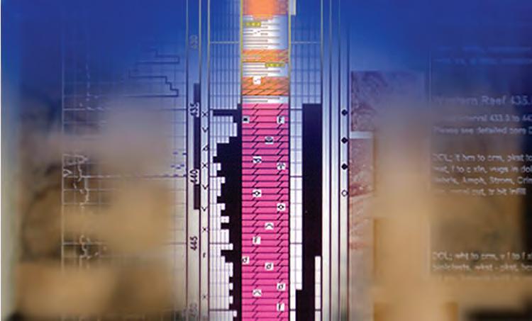
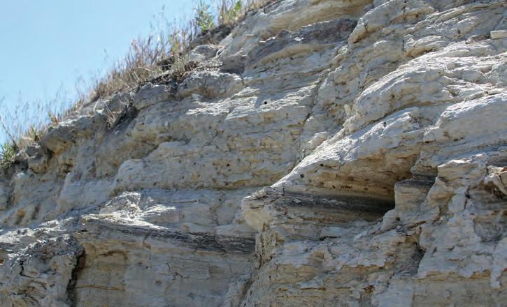
The section of the Monterey Formation found on Palos Verdes has been transported northward approximately 20-30 km from where deposition first occurred. The lower Altamira Formation was deposited directly on the early Mesozoic Catalina Schist basement (Figure 1). In fact, the distinctive blue schist can be seen as rip-up clasts in these basal breccia and/or conglomerate sediments (Figure 3).
Detailed study of the Monterey Formation has allowed for extensive insight into silica diagenesis as well as chert and porcelanite formation as it is possible to see all stages of burial diagenesis and all silica phases (Figures 4, 5).
Silica Phases observed include: a) biogenetic Opal-A, which is a hydrous silica found in
22 RESERVOIR ISSUE 9 • OCTOBER 2012
Figure 3. Classic blue schist clast scoured from the Catalina Schist basement – lower Altamira Formation turbidite.
Figure 4. Temperature and detritus vs. biogenic silica plot; after Behl, 2012, used with permission.Catalina Schist basement – lower Altamira Formation turbidite.
Figure 5. Concentrically fractured chert nodules or spheroids, which indicate early and shallow silica diagenesis.
Figure 2. California Neogene basins; after Behl, 2012, used with permission.
the shells of diatoms and radiolarians, many of which were deposited in the Monterey (Figure 6); b) metastable Opal-CT, which is hydrous silica that forms with burial, increased temperature, or the passage of time as an alteration product from Opal A through dissolution and re-precipitation; and finally c) the end result of stable diagenetic quartz, which is found as fibrous chalcedony or cryptocrystalline to microcrystalline quartz or chert. Temperature and time contribute to these three phases, however the amount of clay, organic matter, and calcium carbonate also affect the silica diagenesis. The presence of clay and organic matter slows the Opal-A change to Opal-CT, but the presence of calcium carbonate speeds up the formation of Opal-CT and possibly quartz formation.
Diagenetic siliceous rocks known as chert and porcelanite have a major difference. Chert is a fairly pure siliceous rock that is dense and hard with a smooth conchoidal fracture and waxy luster and normally is >90 or 95% diagenetic silica. Porcelanite on the other hand is only 50-85% diagenetic silica with the rest being clay content and/or porosity. This makes it less dense than chert and gives it a blocky to splintery fracture and a matte surface resembling unglazed porcelain. Often the porosity is as much as 15-25% and frequently is layered with dark shale.
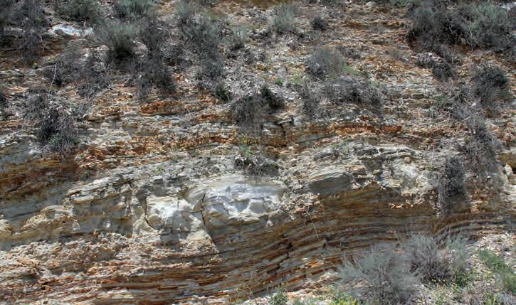
The Monterey deposits include carbonaceous, calcareous, and phosphatic mudrock; dolostone; limestone; and marlstone; in addition to siliceous diatomite, porcelanite, and chert (Figures 7, 8). The massive numbers of diatoms that provided the silicarich material for the formation of these rocks also provided the organic material that generated the bulk of the oil found in the Los Angeles Basin.
REFERENCES
Alt, D. and Hyndman, D.W. 2000. Roadside Geology of Northern and Central California. Mountain Press Publishing, Missoula, MT.
Behl, R.J. 2012. Guidebook to Miocene Monterey Formation of the Los Angeles Basin. CSULB, April 21.
Clarke, D. 2012. The Road to Bakersfield. In: Heavy Oil Production and Outcrops on the East Flank of the San Joaquin Valley. AAPG 2012 Annual Convention Field Trip 15 Guidebook; Energy Minerals Division and the San Joaquin Geological Society.
Sharp, R.P. and Glazner, A.F. 1993. Geology Underfoot in Southern California. Mountain Press Publishing, Missoula, MT.
RESERVOIR ISSUE 9 • OCTOBER 2012 23
Figure 6. Valmonte Diatomite member of the Monterey Formation – white to light grey, laminated diatomite and diatomaceous shale with some grey-brown Opal-CT chert beds and nodules, Del Cerro park, Rancho Palos Verdes, LA.
Figure 7. Lenticular layer with dolostone nodules (white colour) in iron-stained cherty porcelanite, Palos Verdes Peninsula, Monterey Formation.
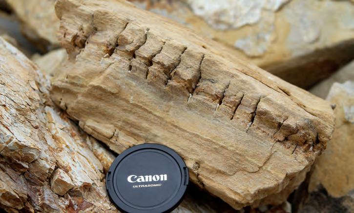
Figure 8. Weathered piece of siliceous shale sandwiching a thin chert layer – this is perfect example of mechanical stratigraphy, which is so important in exploiting unconventional reservoirs. The chert layer is highly jointed and fractured, but the shale above and below is not, even though they were all exposed to the same stress field. Palos Verdes Peninsula, Monterey Formation.
GE OREX – A New Research Symposium at the University of Calgary
| By Tannis McCartney
As it so often happens, it was over beer that a few geosciences graduate students at the University of Calgary began discussing the lack of opportunities for them share their research with their colleagues in the department. A more serious (i.e., sober) discussion followed, and GeoRE x , the Geoscience Research E xchange, was born.
The primary focus of the one-day event, held on April 17, 2012, was the oral presentations from students in the Department of Geoscience. Submissions were restricted to students, but both undergrads and grads were invited to submit abstracts. Since one of the objectives set out by the organizers was to provide an opportunity for students to practice giving talks about their research, no posters were presented. Oral presentation skills are valuable tools to geoscience students, both in their education and in their careers. The presentations represented a broad range of student research within the department, with talks on seismic modeling, palynology, sequence stratigraphy, thermochronology, petrology, borehole geophysics, and Canadian volcanology.
During lunch, participants were treated to a talk from the department’s own Dr. Phil Simony. Dr. Simony described examples from his own experience where on-the-ground field mapping could not be replaced by technology.
One of the objectives of GeoRE x was to open up students’ eyes to the breadth of research happening in the department, and one of the outcomes of the day was to be able to introduce two students who were working on different aspects of the same dataset – one was looking at sequence stratigraphy and one at borehole geophysics in the same hydrocarbon pool. Hopefully seeing other work happening in the same area sparked some new ideas for these students.
The organizers were fortunate to receive one of the inaugural CSPG Student Event Grants, overseen by the University Outreach Committee and funded by the CSPG Education Trust Fund. These funds went towards offsetting the costs of coffee breaks and lunch for the participants, as well as the costs of printing abstract books (copies of which are now at Gallagher Library at the
University of Calgary) and other materials. By offsetting the costs, instead of requiring high registration fees, the GeoRE x committee was able to provide an affordable, informative
day for members of the Department of Geoscience at the University of Calgary. We hope that GeoRE x will become a new tradition at the University of Calgary.
24 RESERVOIR ISSUE 9 • OCTOBER 2012
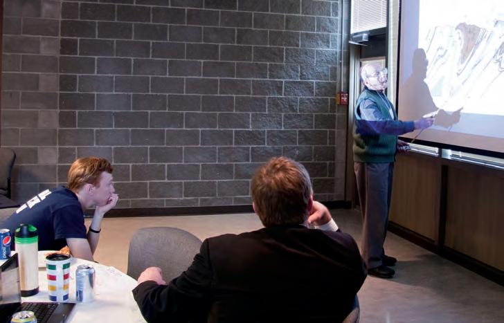
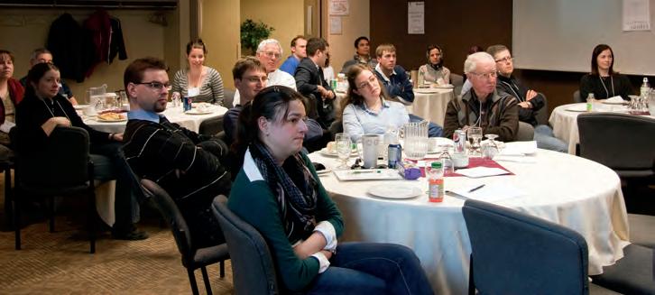
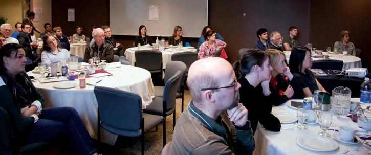
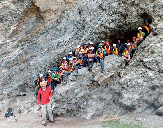
Dr. Phil Simony delivering the keynote address.
GeoREX participants giving their full attention to the speakers.
GeoREX participants giving their full attention to the speakers.
CSPG PROFESSIONAL DEVELOPMENT
CSPG PROFESSIONAL DEVELOPMENT
SHORT COURSES & FIELD SEMINARS
SHORT COURSES
The Stratigraphic Setting of Lower and Middle Triassic Strata
Instructor: Jim Dixon
Dates: October 25, 2012 (Morning Only)
Price: $400.00 CDN Member
$525.00 CDN Non-Member
The Architecture of Fluvial Reservoirs
Instructor: Andrew Miall
Dates: October 25 & 26, 2012
Price: $975.00 CDN Member
$1,100.00 CDN Non-Member
Writing for Earth Scientists: A One -Day Clinic
Instructor: Matt Hall
Dates: October 22, 2012
Price: $625.00 CDN Member
$750.00 CDN Non-Member
Sequence Stratigraphy: Principals and Applications
Instructor: Octavian Catuneanu
Dates: October 22 & 23, 2012
Price: $1,150.00 CDN Member
$1,275.00 CDN Non-Member
Fluvial Stratigraphy
Instructor: John Holbrook
Dates: October 24 & 25, 2012
Price: $1,050.00 CDN Member
$1,175.00 CDN Non-Member
Technology of Multi -Stage Fracing of Horizontal Wells
Instructor: Saad Ibrahim
Dates: October 26, 2012
Price: $620.00 CDN Member
$745.00 CDN Non-Member
SHORT COURSES
Log Analysis for Stimulation Design
Instructor: Ross Crain
Dates: October 24, 2012
Price: $695.00 CDN Member
$820.00 CDN Non-Member
Log Analysis in Unconventional Reservoirs
Instructor: Ross Crain
Dates: October 23, 2012
Price: $695.00 CDN Member
$820.00 CDN Non-Member
Shale Gas Critical Fundamentals, Techniques and Tools for Exploration
Instructor: Basim Faraj
Dates: October 22, 2012
Price: $830.00 CDN Member
$955.00 CDN Non-Member
Directional Drilling and Geological Placement for Beginners
Instructor: Glen Eckert
Dates: October 25, 2012
Price: $850.00 CDN Member
$975.00 CDN Non-Member
Directional Drilling and Geological Placement (Advanced)
Instructor: Glen Eckert
Dates: October 26, 2012
Price: $955.00 CDN Member
$1,080.00 CDN Non-Member
Mannville Stratigraphy, Sedimentology, and Petroleum Geology
Instructor: Doug Cant
Dates: October 15 - 17, 2012
Price: $1,735.00 CDN Member
$1,860.00 CDN Non-Member
SHORT COURSES
Rock Creek Stratigraphy, Sedimentology, and Petroleum Geology
Instructor: Doug Cant
Dates: October 24, 2012
Price: $870.00 CDN Member
$995.00 CDN Non-Member
Subsurface Methods - Core Work and Log Correlation in Clastic Sediments
Instructor: Doug Cant
Dates: October 22, 2012
Price: $1,000.00 CDN Member $1,125.00 CDN Non-Member
REGISTER ONLINE AT www.cspg.org/CSPG/Education
registration for Short
Closes october 10
Courses

GO TAKE A HIKE
Head-Smashed-In Buffalo Jump, Fort Macleod, AB
| By Cory Gross
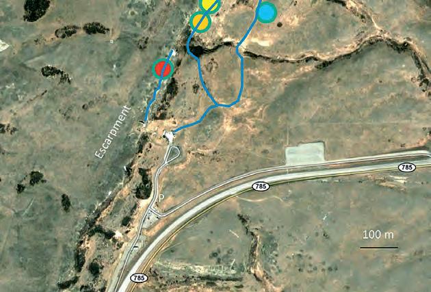
Location: The Interpretive Centre is 18km NW of Fort Macleod on Highway 785.
hours: Interpretive Centre open 10:00am-5:00pm daily. Closed Christmas Eve, Christmas Day, New Years Day, Easter Sunday. Admission fee is charged. trails: In addition to the Interpretive Centre, the locality has two short interpretive trails. One follows along the top of the cliff and is only accessible via the Interpretive Centre. The second follows a loop along the base of the cliff and is accessible to the public.
Head-Smashed-In Buffalo Jump is a recognized UNESCO World Heritage Site preserving over 9,000 years of activity by the First Nations of Southern Alberta. Archaeological layers reach down ten metres, the oldest layer of which yielded spear points dating to 9,000 years ago (and showing that the cliff was once 20 metres high as opposed to the current ten). There is no record of buffalo hunting at the site at this time. By contrast, the most recent layers yield metal arrowheads, proving that the jump was last used in historic times. In between the jump was used hundreds of times, beginning 5,800 years ago, supplying generations of the Nitsitapii (Blackfoot) and their ancestors with meat, bones, hides, and other tissues that were manufactured into the necessities of life.
What made Head-Smashed-In such a productive site was an intimate knowledge of both bison behaviour and the post-glacial geography of the area on the part of First Nations hunters. The locality lies at the southern end of the Porcupine Hills in an area renowned for the largest annual number of Chinooks in Alberta. The high winds and frequent warm spells, coupled with the rolling topography, were appealing to herds of buffalo that would gather in the natural basin several kilometres behind the cliffs. Highway 785 runs through this basin today after passing Head-Smashed-In. Native runners draped in skins of coyote and buffalo calf would slowly manoeuvre the herds into the drive lanes. These lanes utilized natural gullies and were flanked by cairns of rock stuck with branches and leaves. Once inside the drive lanes, bison would be chased from behind and goaded from the sides. The stampeding herd would crest a small ridge just behind the cliff and – disoriented by the combination of land features, yelling and screaming hunters, and mass panic – be driven off the sandstone escarpment. Any bison surviving the fall from the cliff would be slaughtered below. At the end of the drive, carcases would be pulled away to a processing camp further down the slope. This camp took advantage of the natural spring issuing from the base of the cliff. The complex includes a second buffalo jump, Calderwood, as well as pictograph and vision quest sites (not accessible to the public). Though not the only buffalo jump, Head-Smashed-In is the ideal example and perhaps the oldest known.
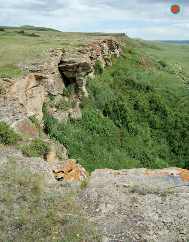
The sandstone cliffs are an outcrop of the Paleocene Porcupine Hills Formation. The depositional setting was a broad floodplain with anastomosing streams that drained shallow lakes. The climate appears to be semi-arid here as the rocks contain caliche (a nodular carbonate cement formed in arid environments) and lack the coals present in the partly time-equivalent Paskapoo to the north. Glacial and post-glacial modification of the strata resulted in a NNE-trending escarpment of which the First Nations hunters were able to take advantage.
reFerences: Brink, Jack W. 2008. Imagining Head-Smashed-In: aboriginal buffalo hunting on the northern plains. AU Press, Athabasca University.
Hamblin, A.P., 2004. Paskapoo-Porcupine Hills formations in Western Alberta: Synthesis of Regional Geology and Resource Potential. Geological Survey of Canada, Open File 4679.
Background Photo by Astrid Arts.
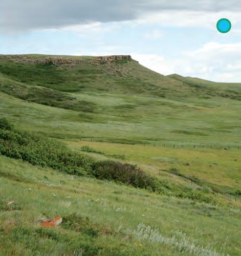
26 RESERVOIR ISSUE 9 • OCTOBER 2012
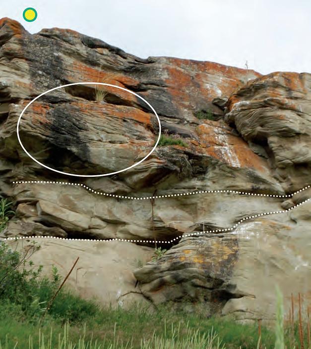
Above: Head-Smashed-In Buffalo Jump viewed from the top interpretive trail. Calderwood Jump is the promontory visible in the distance along the cliff and the lower trail is visible to the right. The Porcupine Hills Formation is a unit of thick, cross-bedded, calcareous channel sandstones interbedded with recessiveweathering mudstone containing paleosols.
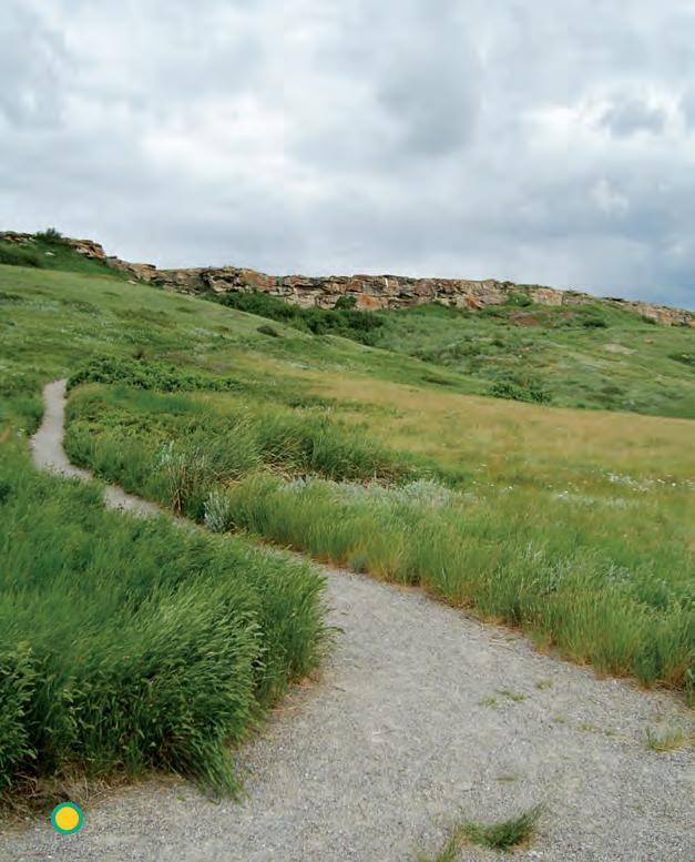
Calderwood Buffalo Jump, a secondary jump in the complex. From this angle one can see the resistant calcareous-cemented channel sandstone forming the escarpment and the gentler slope underneath due to the recessive weathering of fine-grained portions of the Porcupine Hills Formation.
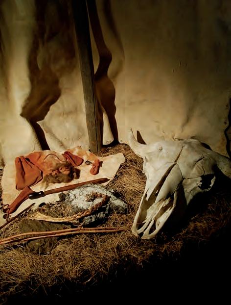
Accoutrements used in the buffalo-calling ritual displayed in the Interpretive Centre, including ochre, sweetgrass, a buffalo skull, and iniskim or “buffalo calling stones” (segments of fossil ammonite).
View of the cliff from the trail loop at its base. Sediments of the Porcupine Hills and Paskapoo formations are sourced from the Rockies, which were rapidly growing at this time. The development of the mountain range forced the retreat of the Western Interior Seaway southwards. The sea had retreated to Manitoba and North Dakota by the earliest Paleocene, leaving a broad plain upon which to deposit sediment (Hamblin, 2004). Up to 3,000m of strata were stripped from the Rockies and recycled onto this plain. By mid Eocene (about 58 Ma) the compressional forces building the Rockies had waned and the foreland basin into which sediment was being deposited began a new cycle of uplift and erosion (which continues today).

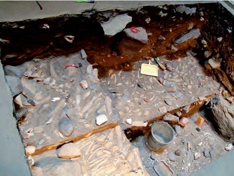
 Reproduction of an archaeological dig at the site displayed in the Interpretive Centre.
RESERVOIR ISSUE 9 • OCTOBER 2012 27
Detail of the Porcupine Hills Formation outcrop. Note the cross-bedding (circled), a common feature of fluvial channels. Channel scour surfaces are represented by dotted lines.
Industry use of hydraulic fracturing (fracking) for stimulating wells has resulted in dramatic productivity increases, notably in unconventional resources such as shale gas. The subject of hydraulic fracturing in the oil and gas industry is regularly discussed in numerous workshops and conferences that disseminate best practices towards delivering increased production. On the other hand, the public perception of ‘fracking’ is focused on perceived negative consequences and has resulted in local to national government moratoriums and the mobilization of numerous opposition groups.
Join us November 6 - 8, 2012 at the Banff Centre as the 2012 Gussow Conference looks to bring clarity to the scientific aspects of hydraulic fracturing within the context of the energy requirements of society and the environmental impacts of the industry.
2012 Technical Program
Keynote Speaker: Tuesday, November 6, 2012
George King, Apache Corporation (Houston)
Session 1 & 2: Science and Engineering of Hydraulic Fracturing
Session Chair: Robert Hawkes, Pure Energy Services
Speakers:
Dan Moos, Baker Hughes
Ron Gusek, Sanjel
Norm Warpinski, Pinnacle
Session 3 & 4: Environmental Impacts Part 1: Seismicity/ Earthquake Potential
Session Chair: Kris Vasudevan, University of Calgary
Speakers:
Jason Hendricks, Nexen
Gillian Foulger, Durham University
Michael Kendall, University of Bristol
Doug Schmidt, University of Alberta
David Eaton, University of Calgary
Session 5 & 6: Environmental Impacts Part 2: Surface/Subsurface Water Impacts
Session Chair: Karlis Muehlenbachs, University of Alberta
Speakers:
Karlis Muehlenbachs, University of Alberta
Don Getzlaf, NCS Energy Services
Alex Haluszka, Matrix Solutions
Richard Jackson, Geofirma Engineering
Session 7 & 8: How Hydraulic Fracture Stimulation has Changed Market Fundamentals, the Economy and Regulations
Session Chair: Carol Crowfoot , ERCB
Speakers:
George Eynon, ERCB
Ken Paulson, BC Oil & Gas Commission
Peter Howard, CERI
Carol Crowfoot, ERCB
Panel Discussion: Cost vs. Benefit of Hydraulic Fracturing
Registration fees: *All registration fees include accommodation, meal package, and conference materials. Regular Registration $1,300.00 CDN Student $900.00 CDN
*Please call Aileen Lozie at (403) 513-1227 if you wish to register over the phone.


Save $300 and register before September 15 at www.cspg.org/gussow
FROM THE REGULATOR’S DESK In Situ Coal Gasification
| By Curtis Evans, Stacy MacDonald, Alex Bolton, and George Eynon
Notes on regulatory issues for industry geologists from regulatory colleagues at the Energy Resources Conservation Board (ERCB).
Alberta is blessed with an abundance of hydrocarbon resources. Coal is one of Alberta’s most abundant fossil fuel resources and is generally extracted using conventional mining methods. Alberta has a long history of surface and underground coal mining, both of which are regulated by the ERCB under the Coal Conservation Act (CCA).
Recent years have seen an increased interest in in situ coal gasification (ISCG). In order to effectively regulate ISCG, the ERCB amended its legislation in 2011 to ensure that the development of coal via this technology occurs in a fair and responsible manner, and is in the public interest.
COAL IN ALBERTA
The ERCB publishes a summary of coal resources and reserves in its annual statistical report, ST98 (1) : Alberta’s Energy Reserves &
Supply/Demand Outlook. A greater level of detail is provided in ST31(2) : Reserves of Coal, Province of Alberta. ST31 has a detailed tabulation of established coal reserves by field, deposit, and mine permit area as well as information on ultimate mineable reserve potential by region.
Mineable coal resources have been the focus of studies for hundreds of years. At this time, the estimated mineable resources and remaining mineable reserves are 93.7 billion tonnes and 33.3 billion tonnes, respectively. (2) Of this, the shallow sub-bituminous coals in the Plains Region are the largest resource. Of the total remaining established reserves, less than 1 per cent (994 million tonnes) were within the permit boundaries of mines active in 2011. (2)
Publications on deep (un-mineable) coal resources have been around since the 1970s. These publications describe a resource that is far larger than other hydrocarbon resources in Alberta. For example, there is
a bituminous coal resource, larger than the sub-bituminous shallow coals in the Plains Region, at depths below mineable limits. With ISCG, there is the potential to develop this un-mineable resource.
T HE ISCG PROCESS
ISCG converts coal in situ into a gas. The product, which is known as synthesis gas (syngas), is primarily composed of carbon dioxide, carbon monoxide, methane, and hydrogen. The reactions required to convert the subsurface coal into syngas are no different from those that occur in surface gasifiers.
Although coal is commonly thought of as a fuel, in the case of ISCG it is a feedstock. In addition to coal, the process requires oxygen, water, and heat. Oxygen is injected as either pure gas, air, or enriched air. Water or steam can be injected, or water within the coal seam can be consumed. Heat is introduced, most often by an ignition fluid, and is maintained by the reaction.
(Continued on page 30...)

RESERVOIR ISSUE 9 • OCTOBER 2012 29
Canadian Discovery Ltd. integrate d geosciences Geoscience Consulting | Multi-Client Studies | Information Products | Completions & Frac Data WWW.CANADIANDISCOVERY.COM
(...Continued from page 29 )
Ash or slag is also produced during the reaction. This waste remains underground, which is a benefit of ISCG over surface gasification.
In order to inject reactants and produce the syngas, wells are often drilled in pairs, or other multiples. Comparisons between in situ oil sands projects and ISCG have been drawn, as both drill multiple wells to inject and produce fluids.
Because ISCG is a thermal process, the wells need to be appropriately designed to handle high temperatures. It is best to construct all wells associated with an ISCG process with thermal cement.
HISTORY OF ISCG
ISCG has a long history in Europe, with tests in the United Kingdom, the Soviet Union, Belgium, Spain, and Uzbekistan. One of those tests, located in Uzbekistan, has commercially produced syngas since the 1950s. A series of tests were conducted in the United States from 1970 to 1990 and, in Australia, tests have been ongoing since 1990.
ISCG also has some history in Alberta. A little-known test was conducted by drilling a short distance into the highwall of the Paintearth mine near Forestburg in 1976. The results were inconclusive. Recently, two experimental ISCG projects were approved by the ERCB. Swan Hills Synfuels Ltd. received all necessary approvals in 2008 for its project, located near Swan Hills. It is the deepest ISCG operation in the world, converting coal in the Upper Mannville, at a depth of approximately 1,400 metres. Laurus Energy Inc. received an experimental scheme approval in 2011 for its project, located in Parkland County. It is a shallow operation, converting coal in the Ardley, at a depth of approximately 220 metres.
N E W LEGISLATION IN ALBERTA
In 2011, the Legislative Assembly of Alberta passed Bill 16 Energy Statues Amendment Act 2011. The ERCB’s CCA and Oil and Gas Conservation Act (OGCA) were amended to allow for the regulation of ISCG projects.
ISCG operators must apply for an in situ coal scheme approval under the CCA. Applications must describe the project, its impacts, and the mitigation of the impacts. An assessment of the impacts usually includes a hydrogeological and geotechnical analysis, and may also require an environmental impact assessment. As with any ERCB application, the applicant must demonstrate that meaningful consultation has occurred.
(Continued on page 33 ...)
30 RESERVOIR ISSUE 9 • OCTOBER 2012
PETROLEUM INDUSTRY COURSES
OVERVIEW OF THE OIL & GAS INDUSTRY IN WESTERN CANADA
Date: November 28th and 29th, 2012
Cost: $945 (includes GST)
Instructor: Bill Ayrton
Effective for personnel just joining the oil patch, or for financial, accounting, and information systems personnel.
• Learn about the many facets of the industry.
• Oil finding, land acquisition, drilling, seismic, well completion, jargon and terminology.
GEOLOGY FOR NON-GEOLOGISTS
Date: December 11th and 12th, 2012
Cost: $945 (includes GST)
Instructor: Bill Ayrton
Effective for geological technicians or administrative staff, or for those who just want a better understanding of geology to appreciate the world around us.
WHO SHOULD ATTEND
New geologists, engineers, geophysicists and landmen, as well as summer students entering the industr y for the first time will find the courses a very beneficial introduction to the petroleu m industry These courses will be extremely useful to nonprofessional and support staff in the oil and gas industry, as w ell as accountants, lawyers, brokerage and financial personnel working primarily alongside the oil and gas industry.
TO REGISTER
To register or to obtain additional information regarding in-house and upcoming courses, please contact:
Ayrton Exploration Consulting Ltd.
Tel: (403) 262-5440
Email: ayrtonex@shaw.c a
Or visit our website: www.ayrtonexploration.com
• Learn about earth structure, geologic time-scale and processes, Western Canada geology, and interesting nearby locations.
• Participate in a r ock identification exercise , cross-section project and a mini-field trip in downtown Calgary.
GEOLOGY OF THE WESTERN CANADIAN SEDIMENTARY BASIN
Date: October 30th, 31st, and November 1st, 2012
Cost: $1365 (includes GST)
Instructor: Bill Ayrton
Ideal for those who wish to improve their geological understanding of where and how we look for oil and gas fields in Western Canada.
• To visualize what Western Canada looked like throughout the stages of history, for example, the position of the sea versus land, what sediments were deposited, and what type of life that existed and evolved.
• To review the importance of each major stratigraphic unit, i.e. Devonian, Mississippian, Cretaceous, etc.
• Discuss the geological and seismic expression of typical oil and gas fields in each unit.
RESERVOIR ISSUE 9 • OCTOBER 2012 31
technology • seismic • rocks • maps • formations • land • sediments • history • sea • fossils • environment
CSPG Student Industry Field Trip
Photo by: Bill Ayrton
GE OLOG Y FO R NON- GE OLOG ISTS Pr esen ted by W.G. ( Bi ll) A yr to
GeoConvention 2013: Integration
May 6 -10
Telus Convention Centre and ERCB Core Research Centre
As Aristotle said, “the whole is greater than the sum of its parts.” In a world that is becoming increasingly complex the need for teamwork, integrated views, synthesis, and brave solutions has never been greater. Today science, technology, and engineering are solving challenges and realising opportunities through collaborative effort. In the energy sector exploration companies have long nurtured teamwork, but roles within teams and the overall makeup are continually shifting.
More than ever geoscientists and engineers are working together, and future success in resource exploration and development will come to those companies that find the right symbiosis. Exploration and production companies in continued collaboration with service companies can achieve their goals more effectively than independently. As such, GeoConvention is preparing a program for 2013 with an emphasis on Integration.
CALL FOR ABSTRACTS
Abstract submissions site of oral, poster, and core presentations for Integration 2013 will begin Monday, November 5.
Presentations that integrate the various disciplines of the geosciences, engineering, technology, the environment, and business are preferred. In order to offer something for everyone, we are designing a technical program that will include large, general themes that encourage multi-disciplinary contributions and will focus on various specific areas within a general topic. We are also planning a range of specialized technical sessions focused on advances in specific disciplines. Major themes are listed below and for a detailed list of proposed sessions please visit our website. Please note that the list of sessions is subject to change. Some sessions may be dropped, some added, and some re-named to better reflect the content of the submitted abstracts.
INVITATION TO SUBMIT
Please contribute to the technical program by submitting an informative and creative presentation that would fit within one of the diverse sessions that have been proposed.
MAJOR THEMES
• Heavy Oil and Oil Sands
• Unconventional Oil and Gas
• Arctic
• Emerging Technology
• New Ideas in Old Conventional Plays
• Resources and Reserves
• Advances in Applied and Theoretical Petrophysics
• Seismic to Simulation
• The Best of Gussow
INCREASE YOUR CORPORATE PROFILE!
Interested in Exhibit, Sponsorship, or Advertising opportunities for the 2013 Convention? Please contact Alyssa Middleton, Assistant Convention Manager, for more information: alyssamiddleton@shaw.ca, 403-453-0181
For more information visit www.geoconvention.com
32 RESERVOIR ISSUE 9 • OCTOBER 2012
If there are any objections to the project, a public hearing could result.
If an applicant receives an in situ coal scheme approval, it requires two additional ERCB approvals prior to constructing and operating the scheme.
The applicant must apply under the OGCA for necessary well, facility, and pipeline licenses. If the requirements of Directive 056 (3) : Energy Development Applications and Schedules are met at the scheme approval stage, the well, facility, and pipeline licence applications may be processed routinely.
After a well licence is obtained and an injection well is drilled, the applicant must apply for an approval to inject the required fluids. This application must meet the requirements described in Directive 051(4): Injection and Disposal Wells – Well Classifications, Completions, Logging, and Testing Requirements.
This three-step approval process is similar to the ERCB’s approval process for in situ oil sands projects.
During the development of the ISCG
legislation, the ERCB determined that wells, facilities, and pipelines associated with an ISCG project must be constructed, operated, suspended, and abandoned in accordance with existing legislation. Similar to other industry production operations, ISCG operators must also report production and injection volumes to the Petroleum Registry of Alberta.
ISCG GEOMECHANICS
Coal behaves as a solid at near-surface temperatures and pressures. However, in the deeper subsurface coal seams can exhibit ductile movement as the coal behaves plastically and changes shape due to overburden pressure. CSPG members who have read reports about, or witnessed a deep coal seam moving and bridging-off a well are familiar with this phenomena. This plasticity is a challenge for very deep ISCG operators, as keeping the communication path between the production and injection wells open can be more difficult with greater pressure. Ensuring that the injection and production wells are able to communicate is important to the operation, as syngas cannot be produced without it.
A full assessment of the geomechanical properties of the coal and surrounding
GEOEDGES INC.
and accurate geology at your fingertips in Petra, GeoGraphix, ArcGIS, AccuMap, GeoScout and other applications
/ Appalachian Basin Geological Edge Set North American Shales Geological Edge Set
Texas & Midcontinent US Geological Edge Set
strata is essential to determining how the communication path will be established and maintained. It is also necessary to understand the long-term viability of the ISCG project. The subsurface gasification chamber and its products, which develop in the coal seam, must be contained by the confining strata. The strata immediately above the coal must also support higher strata, to prevent any subsidence.
GROUNDWATER PROTECTION
Given the nature of the ISCG process, there is potential for groundwater contamination. Alberta Environment and Sustainable Resource Development (ESRD) and the ERCB work together on groundwater issues.
The risk of groundwater contamination is greater in operations near aquifers or in shallow coals. However, the risk is easily mitigated by appropriate design and operational procedures. The chamber pressure must be kept at a pressure lower than in the surrounding strata, to ensure that fluids are either produced via the production wells or contained within the producing horizon. If the chamber pressure is too high, injected fluids and syngas may migrate into the surrounding aquifers or strata.
Western Canada: Slave Point, Swan Hills, Leduc, Grosmont, Jean Marie, Horn River Shales, Elkton, Shunda, Pekisko, Banff, Mississippian subcrops and anhydrite barriers in SE Sask., Bakken, Three Forks, Montney, Halfway, Charlie Lake, Rock Creek, Shaunavon, BQ/Gething, Bluesky, Glauconitic, Lloyd, Sparky, Colony, Viking, Cardium, Horseshoe Canyon and Mannville CBM, Oilsands Areas, Outcrops
US Rockies & Williston: Red River, Mississippian subcrops & anhydrite barriers (Bluell, Sherwood, Rival, etc), Bakken, Three Forks, Cutbank, Sunburst, Tyler, Heath, Muddy, Dakota, Sussex, Shannon, Parkman, Almond, Lewis, Frontier, Niobrara, Mesaverde shorelines, Minnelusa, Gothic, Hovenweep, Ismay, Desert Creek, Field Outlines, Outcrops
Texas & Midcontinent: Permian Basin paleogeography (Wolfcampian, Leonardian, Guadalupian), Granite Wash, Mississippian Horizontal Play, Chat, Red Fork, Morrow, Sligo/Edwards Reefs, Salt Basins, Frio, Yegua, Wilcox, Eagleford, Tuscaloosa, Haynesville, Fayeteville-Caney, Woodford, Field Outlines, Outcrops, Structures
North American Shales: Shale plays characterized by O&G fields, formation limit, outcrop, subcrop, structure, isopach, maturity, stratigraphic cross-sections. Includes: Marcellus, Rhinestreet, Huron, New Albany, Antrim, Utica-Collingwood, Barnett, Eagleford, Niobrara, Gothic, Hovenweep, Mowry, Bakken, Three Forks, Monterey, Montney, Horn River, Colorado
Eastern US / Appalachia: PreCambrian, Trenton, Utica-Collingwood, Medina-Clinton, Tuscarora, Marcellus, Onondaga Structure, Geneseo, Huron, Antrim, New Albny, Rhinestreet, Sonyea, Cleveland, Venango, Bradford, Elk, Berea, Weir, Big Injun, Formation limits, Outcrops, Allegheny Thrust, Cincinatti Arch, Field outlines
Deliverables include:
-Shapefiles and AccuMap map features
-hard copy maps, manual, pdf cross-sections
-Petra Thematic Map projects, GeoGraphix projects, ArcView map and layers files
-bi-annual updates and additions to mapping
-technical support
RESERVOIR ISSUE 9 • OCTOBER 2012 33
Western Canada Geological Edge Set Northern US Rockies & Williston Basin Geological Edge Set Eastern US
for
Joel Harding at 403 870 8122 email joelharding@geoedges.com www.geoedges.com
Detailed
information contact:
(...Continued from page 30 )
(Continued on page 34...)
CORPORATE MEMBERS
ALLEN GEOPHYSICAL CONSULTING LTD
APACHE C ANADA LTD
APEGA
BAKER ATLAS
B DO C ANADA LLP
BLACK SWAN ENERGY
BLUEBACK RESERVOIR
C ANADIAN NATURAL RESOURCES LTD
C A SEY & AS SOCIATES
CENOVUS
CSEG FOUNDATION
CONOCOPHILLIPS C ANADA LIMITED
DE VON C ANADA CORPORATION
ENCANA
E NERPLUS CORPORATION
E x xON MOBIL UPSTREAM RESEARCH COMPANY
GEOLOGIC SYSTEMS LTD
GEOSTRATA RESOURCES INC.
GEOVARIANCES
GLJ PETROLEUM CONSULTANTS LTD
HALLIBURTON
H U NT OIL COMPANY OF C ANADA
H USKY ENERGY INC.
IHS
IM PERIAL OIL RESOURCES
JEWELSUITE
LED S IGNS
LITTLE ROCK DOCUMENT SYSTEMS
LORING TARCORE LABS
MJ SYSTEMS
M URPHY OIL COMPANY
NE xE N INC
PARADIGM
PE NN WEST PE TROLEUM LTD
PE TROCRAFT PRODUCTS LTD
PLUSPETROL S.A.
ROKE TECHNOLOGIES
ROx AR
RPS E NERGY C ANADA LTD
SCHLUMBERGER
S HELL C ANADA LIMITED
S IGMA E xPLORATIONS INC.
S PROULE AS SOCIATES LIMITED
STATOIL
SU NCOR E NERGY INC
TALISMAN ENERGY INC
TOTAL E&P CANADA LTD.
TOU RMALINE OIL CORP
TUCKER ENERGY SERVICES
U NITED OIL AND GAS CONSULTING
WEATHERFORD LABORATORIES
AS OF SEPTEMBER 10, 2012 CSPG
The gasification process requires water. If the coals contain sufficient groundwater, there is no need to inject water to support the gasification process. ESRD requires an ISCG operator to obtain approval under the Water Act if it intends to use groundwater as part of its process.
RESOURCE CONFLICT
The ISCG process would consume any coalbed methane (CBM) contained within the coal seam that is being converted. To reduce the chance of resource conflict between CBM operators and ISCG operators, an ISCG applicant must hold both the petroleum and natural gas (PNG) and coal rights for the coal seam that would be gasified. This is required by the Mineral Rights Information Bulletin 2012-03 and the CCA. Currently, there is no system in place to administer tenure for ISCG, and agreements are developed on an individual basis.
PUBLIC CONCERNS
There has not been much media coverage in Alberta about ISCG, but members of the public who are aware of this technology have raised several concerns. The main concerns are about the potential for surface subsidence and groundwater contamination, as well as the very idea that coal is being “set on fire” underneath them.
Potential subsidence, if it is a concern due to the depth of the operation, can be mitigated. For example, pillars of coal can be left to provide support for the roof of the in situ gasification chamber. During the application process, the ERCB requires a geotechnical analysis and report demonstrating that subsidence will be negligible. The ERCB also requires monitoring of subsidence for any shallow ISCG operation.
Baseline groundwater data and modeling are also required for the application process, to demonstrate that groundwater would not be contaminated. For any ISCG operation near aquifers or in shallow coals, monitoring is required.
ISCG operations do not “set coal on fire.”
The gasification reaction that occurs is a highly controlled process and an applicant is required to describe how it intends to control the process. An ISCG scheme can be readily shut down by stopping the injection of oxygen, provided there is no other oxygen source. During the application process an applicant must address any potential for oxygen influx from subcrop exposure, mines, wells, or other subsurface infrastructure that could affect the applicant’s ability to control or stop the reaction.
T HE GEOSCIENTISTS’ ROLE
As professionals in the energy industry, we have an obligation to inform the public to earn and maintain a social license to operate.
This article discussed the ISCG process, its history in Alberta, the province’s new legislation for this emerging technology, and some specific concerns related to ISCG. The article is intended to educate professional geoscientists about ISCG, allowing them to talk knowledgeably to neighbours, friends, and acquaintances.
There is limited public information about ISCG. Professional geoscientists play a role in ensuring both the public and the media have access to reliable information about this technology. The future of ISCG will depend, in part, on how well the regulators and the energy industry respond to the potential risks and public concerns related to this technology.
REFERENCES
(1) ST98-2011: Alberta’s Energy Reserves 2010 and Supply/demand Outlook 2011-2020 [http://www.ercb.ca/sts/ST98/ST98-2012.pdf]
(2) ST2000-31: Reserves of Coal, Province of Alberta [http://www.ercb.ca/data-andpublications/statistical-reports/ST31]
(3) Directive 056: Energy Development Applications and Schedules [http://www. ercb.ca/regulations-and-directives/directives/ directive056]
(4) Directive 051: Injection and Disposal Wells
- Well Classifications, Completions, Logging, and Testing Requirements [http://www.ercb. ca/regulations-and-directives/directives/ directive051

welcomes our 2012 Corporate
The benefits of being a corporate member include: • Recognition in the monthly Reservoir and quarterly Bulletin • One associate membership • Reserved tables at the technical luncheons with your company logo • One free pass to the CSPG Core Conference …and more! Contact Kasandra Klein at kasandra.klein@cspg.org to be a corporate member today! 34 RESERVOIR ISSUE 9 • OCTOBER 2012 geoConvention 2013: i n tegration Call F o r aBS t raC t S O pening early November at www.geoconvention.com. More details to follow shortly.
Members!
(...Continued from page 33 )
www.apega.ca
Meet Guillermo, APEGA’s New IEG Representative
The Association of Professional Engineers and Geoscientists of Alberta (APEGA) is pleased to welcome Guillermo Barreiro, P.Eng., as the new Manager of Internationally Educated Graduate (IEG) Integration and Liaison.
With the support of the Registration Department, Guillermo plans to assist, help and coordinate:
• assist IEG applicants one-on-one to help them understand APEGA’s registration process and policies
• help IEG applicants complete their work experience documents in a language that is relevant to the Board of Examiners
• coordinate outreach activities with immigrant servicing agencies to better explain the APEGA registration process and policies to newcomers to Canada
An IEG himself, Guillermo comes to APEGA after being in the engineering profession for 10 years in Columbia and Canada.
Are you an IEG who needs assistance or advice on your APEGA application? Then contact Guillermo by email at gbarreiro@apega.ca or toll-free at 800-661-7020 ext. 2227.
Professionals in Geoscience
Guillermo Barreiro, P.Eng.

Geomodeling,
Consultancy
Custom

Interpretation and Reservoir Engineering
efficient plug-ins to do more, faster in Petrel
Services Innovative
Blueback Reservoir the preferred and chosen GeoScience Solutions Partner Blueback Reservoir T +1 403 538 4821 E information@blueback-reservoir.com blueback-reservoir.com Learn more? Contact us today or visit us at the SPE ATCE 2012 booth #2164 in San Antonio, TX
Software Development