

15 Clarifying Dataroom Confusion 18 Go Take a Hike 21 Advanced Mud Gas and Rock-Fluid Analysis Aids Evaluation of North American Unconventional Plays 28 2013 Advances in Earth Sciences Research Conference $10.00 JUNE 2013 VOLUME 40, ISSUE 6 Canadian Publication Mail Contract – 40070050


> GEOSCIENCE SOFTWARE
> CRITICAL INFORMATION
> CONNECTED WORKFLOWS


CONNECTED AT E V ERY TOU CH P OI
N T


The IHS suite of geoscience software—which includes IHS Petra®, Kingdom®, LOGarc™ and GeoSyn™—is designed to seamlessly connect to the industry’s leading source of critical Oil & Gas information, eliminating the need to move data manually from source to source and project to project. With this powerful new combination, users can streamline data transfer, enhance database performance and simplify project sharing. The result? Workflows that connect like never before.
Connected workflows mean that IHS customers spend less time looking for data and more time looking for the next big opportunity. It’s just one of the many ways that IHS helps to advance the decisions that advance the Oil & Gas industry.
Find out more at IHS.com/geoscience

Streamline data transfer and simplify project sharing with IHS geoscience software and critical O&G information.
CSPG OFFICE
#110, 333 – 5th Avenue SW Calgary, Alberta, Canada T2P 3B6
Tel: 403-264-5610
Web: www.cspg.org
Office hours: Monday to Friday, 8:30am to 4:00pm
Executive Director: Lis Bjeld
Tel: 403-513-1235, Email: lis.bjeld@cspg.org
Event Coordinator: Kristy Casebeer
Tel: 403-513-1226, Email: kristy.casebeer@cspg.org
Geoscience Coordinator: Kelsey Green
Tel: 403-513-1225, Email: kelsey.green@cspg.org
Member Services:
Tel: 403-264-5610, Email: membership@cspg.org
Publications and Website: Emma MacPherson
Email: emma.macpherson@cspg.org, Tel: 403-513-1230
Co-Manager, GeoConvention 2014: Aileen Lozie
Tel: 403-513-1227, Email: aileen.lozie@cspg.org
Database Administrator and Accounting: Kasandra Amaro
Maternity leave until January 2014
Corporate Sponsorship: Lis Bjeld
Tel: 403-513-1235, Email: lis.bjeld@cspg.org
Controller: Eric Tang
Tel: 403-513-1232, Email: eric.tang@cspg.org
EDITORS/AUTHORS
Please submit RESERVOIR articles to the CSPG office. Submission deadline is the 23rd day of the month, two months prior to issue date. (e.g., January 23 for the March issue).
To publish an article, the CSPG requires digital copies of the document. Text should be in Microsoft Word format and illustrations should be in TIFF format at 300 dpi., at final size. For additional information on manuscript preparation, refer to the Guidelines for Authors published in the CSPG Bulletin or contact the editor.
Technical Editors
Hugh S. Mosher Colin Yeo (Assistant Tech. Editor) Nunaga Resources Ltd. Encana Corporation M.: 403-809-9997 Tel: 403-645-7724
Email: hsmosher@telus.net Email: colin.yeo@encana.com
Coordinating Editor
Emma MacPherson, Publications Coordinator, CSPG Tel: 403-513-1230, emma.macpherson@cspg.org,
ADVERTISING
Advertising inquiries should be directed to Emma MacPherson, Tel: 403-513-1230 email: emma.macpherson@cspg.org. The deadline to reserve advertising space is the 23rd day of the month, two months prior to issue date.

RESERVOIR ISSUE 6 • JUNE 2013 3 MAY 2013 – VOLUME 40, ISSUE 5 ARTICLES 24th Annual CSPG Mixed Golf Tournament 11 The Carbonate Liars Club of Calgary – 25 Year Anniversary 12 Call for Nominations ..................................................................................................................... 13 Clarifying Dataroom Confusion ................................................................................................. 15 Go Take A Hike 18 Advanced Mud Gas and Rock-Fluid Analysis Aids Evaluation of North America Unconventional Plays ................................................................................. 21 Photo of the Month ....................................................................................................................... 25 Medal of Merit 2012 Formal Citation 26 2013 Advances in Earth Sciences Research Conference 28 25th Annual CSPG/CSEG/CAPL 10km/5km Road Race and Fun Run 29 H.M. Hunter Award 2012 Citation ........................................................................................... 30 DEPARTMENTS Executive Comment 5 Technical Luncheons 8 Division Talks 11 Rock Shop ..................................................................................................................... 7, 14, 20 FRONT COVER Mt. Fuji, Honshu, Japan. An active stratovolcano that last erupted in 1707-1708, Mt. Fuji lies approximately 100 kilometers southwest of Tokyo and is the highest mountain in Japan. Photo by Mike Lam.
Society’s
technical
non-technical material
RESERVOIR’s submission guidelines can be found at http://www.cspg. org/publications/pubs-reservoir-submissions.cfm. The contents of this publication may not be reproduced either in part or in full without the consent of the publisher. Additional copies of the RESERVOIR are available at the CSPG office. No official endorsement or sponsorship by the CSPG is implied for any advertisement, insert, or article that appears in the Reservoir unless otherwise noted. All submitted materials are reviewed by the editor. We reserve the right to edit all submissions, including letters to the Editor. Submissions must include your name, address, and membership number (if applicable). The material contained in this publication is intended for informational use only. While reasonable care has been taken, authors and the CSPG make no guarantees that any of the equations, schematics, or devices discussed will perform as expected or that they will give the desired results. Some information contained herein may be inaccurate or may vary from standard measurements. The CSPG expressly disclaims any and all liability for the acts, omissions, or conduct of any third-party user of information contained in this publication. Under no circumstances shall the CSPG and its officers, directors, employees, and agents be liable for any injury, loss, damage, or expense arising in any manner whatsoever from the acts, omissions, or conduct of any third-party user. Designed and Printed by The Data Group of Companies, Calgary, Alberta.
The RESERVOIR is published 11 times per year by the Canadian Society of Petroleum Geologists. This includes a combined issue for the months of July and August. The purpose of the RESERVOIR is to publicize the
many activities and to promote the geosciences. We look for both
and
to publish. Additional information on the
PetroFecta® from Fluid Inclusion Technologies is a unique approach combining XRF (PDQ-XRF ®), Trapped Fluid Analysis (FIS ®), and High Resolution Photography (RockEye ®) of the entire wellbore from well cuttings or core samples of any age. All analyses are conducted on the same 1 gram sample (up to 575 samples per well) with an analytical cycle of four days. Data provided on a DVD with previewer software. Information about PetroFecta ® and the umbrella of FIT services, call 918.461.8984 or visit www.fittulsa.com


CSPG EXECUTIVE
President
Paul MacKay • Shale Petroleum Ltd. paul.mackay@shalepetroleum.com Tel: 403.457.3930
President elect
Dale Leckie • Nexen Inc. daleleckie@nexeninc.com Tel: 403.613.0458
Past President
Robin Mann • AJM Deloitte rcmann@deloitte.ca Tel: 403.648.3210
Finance director
Samantha Etherington • Barrick Energy SEtherington@barrick-energy.com Tel: 403.386.6459
Finance director elect
Gord Stabb • Durando Resources Corp. gstabb@durando.ca Tel: 403.819.8778
director
Dave Russum • AJM Deloitte drussum@deloitte.ca Tel: 403.648.3228
director Alexis Anastas • Nexen Inc. alexis_anastas@nexeninc.com Tel: 403.699.4965
director
Mike Seifert • Canadian Discovery mseifert@canadiandiscovery.com Tel: 403.269.3644
director
Weishan Ren • Statoil Canada Ltd. wren@statoil.com Tel: 403.724.0325
director Curtis Evans • ERCB curtis.evans@ercb.ca Tel: 403.297.8386
director Dawn Hodgins • Imperial Oil Resources dawn.hodgins@exxonmobil.com Tel: 403.232.5931
director Andrew Fox • MEG Energy Corp. andrew.fox@megenergy.com Tel: 403.770.5345
e xecutive director
Lis Bjeld • CSPG lis.bjeld@cspg.org Tel: 403.513.1235
EXECUTIVE COMMENT
A message from Dale Leckie, President Elect
What’s in a Publication?
Traditionally, the brand of a Scientific Society is marked by its publications. Publications provide a method for technical growth of the membership and a means for the society to network and to communicate sociably and technically.
As “Canada’s Energy Geoscientists,” the Canadian Society of Petroleum Geologists publishes several types of publications. These include the CSPG Reservoir, Bulletin of Canadian Petroleum Geology, Memoirs and Special Publications. There are also ad-hoc publications such field guidebooks, core conference publications and extended abstracts.
Our most popular publication is the CSPG Reservoir, which is distributed monthly in paper form and digitally to all members. Bright and vibrant, the Reservoir represents the pulse of the Society – it provides all members with Executive perspectives, like this one. It showcases series of interest to members, honors its members, and announces upcoming events, especially the biweekly Technical Luncheons and Division Talks. The Reservoir is an important vehicle to provide an advertising profile for its consulting members, service companies and organizations wishing to connect with CSPG’s 3000 members. It is the medium to communicate about upcoming CSPG sponsored social events such as the golf and squash tournaments. “Go Take a Hike” gives us short, punchy and wellillustrated geological field guides.
The Bulletin of Canadian Petroleum Geology is the scientific flagship of the Society. Bulletin Editors are Dr. Burns Cheadle (Western University) and Dr. David Morrow (Geological Survey of Canada). Supported by several Associate
Editors, Bulletin Editors provide the rigor needed for peer-reviewed publication.
Recently, CSPG President, Paul MacKay, and I have been discussing with some provincial surveys about the possibility of these institutions utilizing the Bulletin of Canadian Petroleum Geology as a means of conveying peer-reviewed scientific papers to the Society Members and the broader geological community. The Bulletin would then provide broader and peer-reviewed exposure to the work of the government institutions.
I am concerned that the Bulletin is languishing, definitely not due to the fine job that the Editors are doing. Rather, scientific submissions for consideration to be published are not as forthcoming as they should be and used to be. Why is this the case?
The Bulletin of Canadian Petroleum Geology can use your geoscience contribution. Are you a University graduate student with a thesis that needs to be condensed and published? Are you a university academic with a scientific contribution that should be published in the Bulletin of Canada’s Premier Geological Society? Are you a government geoscientist with the need for a peer-reviewed publication outlet other than internal government open file reports, memoirs or papers? The CSPG Bulletin is the outlet for your petroleumbased scholarly efforts.
Are you an energy geoscientist working for an exploration or development department? Do you have new insights into petroleum geology from Canada or abroad – insights from which your Society colleagues might benefit? Why (Continued on page 7...)
RESERVOIR ISSUE 6 • JUNE 2013 5
U PCOMING EDUCATION SCHEDULE EDUCATION UPCOMING EDUCATION SCHEDULE
Last Chance
Lacustrine Basin Exploration Field Seminar
June 9-16, 2013 Utah
Summer Education Conference – 12 courses over 5 days!
June 10-14-2013 Fort Worth, Texas
Field Seminars
Seismic Interpretation in Fold-and-Thrust Belts
July 21-27, 2013 Canada
Fractures, Fold and Faults in Thrusted Terrains
July 22-27, 2013 Montana
Structure, Tectonics and Sedimentary Basin Analysis
August 17-25, 2013 Montana
Sedimentology and Sequence Stratigraphic Response of Paralic September 19-26, 2013 Deposits to Changes in Accommodation Colorado/Utah
Complex Carbonate Reservoirs
Sept. 28-Oct. 4, 2013 Italy
Short Courses
Basic Well Log Analysis
July 29-Aug. 2, 2013 Golden, CO
Application of Structural Geology in Prospecting in August 19-23, 2013 Thrusted and Extensional Terrain Jackson Hole, WY
Fractured Reservoirs: From Geologic Concepts To Reservoir Models September 9-13, 2013 Casper, WY
Practical Salt Tectonics
November 4-7, 2013 Houston, TX
Online
Leadership and Strategic Thinking in the Oil & Gas Industry
Introduction to Shale Gas
Unconventional Resources
Traditional course
Certificate Course
Certificate Course

Registration and Information: Toll-free (U.S. and Canada) (888) 338.3387, or (918) 560.2650 • Fax: (918) 560.2678 • email: educate@aapg.org Download a registration form at http://www.aapg.org/education/index.cfm
CORPORATE SPONSORS
DiaMon D
GeoLOGIC Systems Ltd.
Platinu M
APEGA
Cenovus Energy
ConocoPhilips Canada
Nexen
GolD
Devon Energy Corp.
IHS
Imperial Oil Ltd.
PLS Shell Canada Limited
Statoil
Silver Arc Resources
Athabasca Oil Corporation
CNRL
CSEG Foundation
CSPG Educational Trust Fund
Encana Corporation
Enerplus
EOG Resources
LED Signs
MEG Energy Corp.
Roke Technologies Ltd.
TAQA North Ltd.
Bronze
AGAT Laboratories
Apache Canada
Husky Energy Inc.
Loring Tarcore
Poggenpohl
RIGSAT Communications
RPS Energy
Schlumberger Canada Limited
Sensor Geophysical Ltd.
Suncor Energy
Talisman Energy
As of May 2013
A Special Thanks to Geologic Systems Ltd.,
C SPG ’s Top Sponsor of the Month
(...Continued from page 5)
should industry geoscientists consider publishing in the Bulletin of Canadian Petroleum Geology? Publishing helps to raise the corporate technical profile of one’s company. This, in turn, can help in recruiting highly skilled technical staff, raising your company’s corporate profile when doing business deals, especially in foreign countries, and enhancing one’s career opportunities within an organization. It can expand your sphere of technical influence internally and externally. Over the years, I have published 16 papers in the Bulletin, co-edited one Memoir on sequence stratigraphy and one special publication on shale gas of the Horn River. I feel that making the effort to deliver these publications has thoroughly enhanced my career and the profile of the organization that I worked for.
Have you partaken in a Gussow Conference or a Special Session at GeoConvention 2013? Five or six papers can comprise a special publication of the Bulletin. For example, in 2011, the CSPG Gussow Conference, entitled Closing the Gap: Advances in Applied Geomodeling for Hydrocarbon Reservoirs, was organized and chaired by David Garner of Statoil. This Gussow Conference was extremely popular and well attended. Important to the scientific mandate of the Society, is the timely release of a new CSPG Memoir 20, edited by David Garner on the topic of the conference.
New publication initiatives being considered at CSPG include looking at some form of e-book publishing for digital access for all CSPG publications. We are considering the appointment of a Managing Director for the Bulletin to help increase the number of manuscript submissions.
All publications in Bulletin of Canadian Petroleum Geology are eligible to be considered for the prestigious CSPG “Medal of Merit”. This is quite the honor to be recognized as author of the best paper published during the previous year on a subject related to the petroleum geology of Canada. I know the honor – I have received three of these medals throughout my career.
Are you ready to publish?
Give us a call at 403-246-5610 or check out our website at: http://www.cspg.org/ CSPG/Publications/Bulletin/CSPG/ Publications/Bulletin.aspx?hkey=de83e7a3c893-40bd-b090-28e5bb880176
CorreCtion
The spelling of Marian Warren’s last name was incorrect in the Spring Short Courses listing found in the April 2013 edition of the Reservoir. We apologize for this error.
ROCK SHOP
RESERVOIR ISSUE 6 • JUNE 2013 7
CHAD Data Magnetic & Gravity data for the Western Canadian Basin John W. Peirce, P. Geo. Chief Geophysicist www.chad-data.com 250.616.6914
tecHnical luncHeons JUNE LUNCHEON
The
Cenozoic geological history of the outer continental margin off Nova Scotia, Canada: Insights into margin evolution from a mature passive margin
SPEAKER
Calvin Campbell
11:30 am
tuesday, June 4th, 2013 c algary telus c onvention c entre e xhibition Hall e , n orth Building c algary, a lberta
Please note: the cut-off date for ticket sales is 1:00 pm, thursday, May 30, 2013. csPG Member ticket Price: $45.00 + Gst. nonMember ticket Price: $47.50 + Gst.
Each CSPG Technical Luncheon is 1 APEGA PDH credit. Tickets may be purchased online at www.cspg.org.
Ab STRACT
The continental margin off Nova Scotia (herein the Scotian margin) forms the northern edge of the North American
GEOEDGES INC.
Webcasts sponsored by

Basin. The margin is an area of active hydrocarbon exploration with significant work commitments recently announced. The Cenozoic stratigraphy and geological history of the outer margin is not well known. The primary goal of this study was to determine the geological history of large (~50 000 km2) Cenozoic deep-water depocenter located along the Scotian margin. Consequently, specific aspects of continental margin development were addressed including processes that lead to deep-water unconformity formation, the role of deep-ocean circulation in margin evolution, and the effects of morphological heritage on subsequent depositional patterns. High quality 2-D and 3-D seismic reflection data along with lithostratigraphic and biostratigraphic data from wells collected in support of hydrocarbon exploration provide the basis for this investigation. These data allow detailed study not previously possible anywhere on the North American Basin margin.
Results from this study show that the Cenozoic depositional architecture of the Scotian margin is remarkably similar to the U.S. margin to the south. Pre-existing
Detailed and accurate geology at your fingertips in Petra, GeoGraphix, ArcGIS, AccuMap, GeoScout and other applications for information contact: Joel Harding at 403 870 8122 email joelharding@geoedges.com www.geoedges.com
Western Canada: Slave Point, Swan Hills, Leduc, Grosmont, Jean Marie, Horn River Shales, Elkton, Shunda, Pekisko, Banff, Mississippian subcrops and anhydrite barriers in SE Sask., Bakken, Three Forks, Montney, Halfway, Charlie Lake, Rock Creek, Shaunavon, BQ/Gething, Bluesky, Glauconitic, Lloyd, Sparky, Colony, Viking, Cardium, Horseshoe Canyon and Mannville CBM, Oilsands Areas, Outcrops
Northern US Rockies & Williston Basin Geological Edge Set
Western Canada Geological Edge Set
North American Shales Geological Edge Set
Eastern US / Appalachian Basin Geological Edge Set
Texas & Midcontinent US Geological Edge Set
US Rockies & Williston: Red River, Mississippian subcrops & anhydrite barriers (Bluell, Sherwood, Rival, etc), Bakken, Three Forks, Cutbank, Sunburst, Tyler, Heath, Muddy, Dakota, Sussex, Shannon, Parkman, Almond, Lewis, Frontier, Niobrara, Mesaverde shorelines, Minnelusa, Gothic, Hovenweep, Ismay, Desert Creek, Field Outlines, Outcrops
Texas & Midcontinent: Permian Basin paleogeography (Wolfcampian, Leonardian, Guadalupian), Granite Wash, Mississippian Horizontal Play, Chat, Red Fork, Morrow, Sligo/Edwards Reefs, Salt Basins, Frio, Yegua, Wilcox, Eagleford, Tuscaloosa, Haynesville, Fayeteville-Caney, Woodford, Field Outlines, Outcrops, Structures
North American Shales: Shale plays characterized by O&G fields, formation limit, outcrop, subcrop, structure, isopach, maturity, stratigraphic cross-sections. Includes: Marcellus, Rhinestreet, Huron, New Albany, Antrim, Utica-Collingwood, Barnett, Eagleford, Niobrara, Gothic, Hovenweep, Mowry, Bakken, Three Forks, Monterey, Montney, Horn River, Colorado
Eastern US / Appalachia: PreCambrian, Trenton, Utica-Collingwood, Medina-Clinton, Tuscarora, Marcellus, Onondaga Structure, Geneseo, Huron, Antrim, New Albny, Rhinestreet, Sonyea, Cleveland, Venango, Bradford, Elk, Berea, Weir, Big Injun, Formation limits, Outcrops, Allegheny Thrust, Cincinatti Arch, Field outlines
Deliverables include:
-Shapefiles and AccuMap map features -hard copy maps, manual, pdf cross-sections
-Petra Thematic Map projects, GeoGraphix projects, ArcView map and layers files
-bi-annual updates and additions to mapping -technical support
8 RESERVOIR ISSUE 6 • JUNE 2013
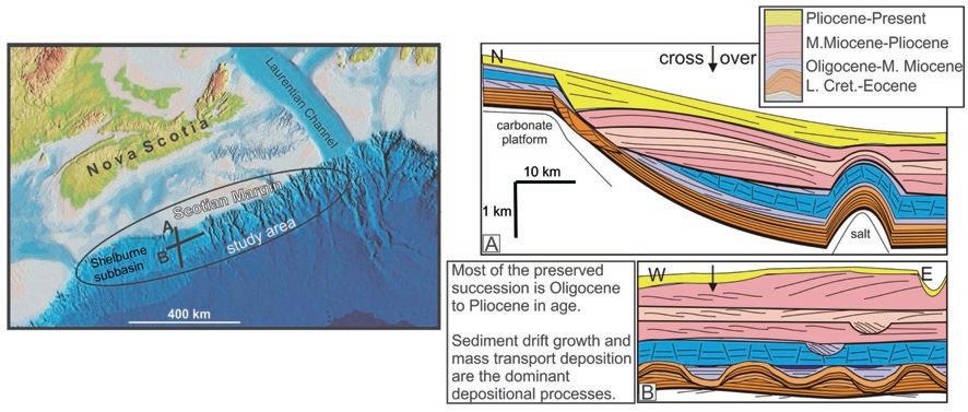
structural features yielded considerable control over subsequent depositional patterns. Canyon erosion was widespread during the Middle Eocene and Quaternary, but also occurred during the Oligocene, Middle Miocene, and Late Miocene. Masstransport deposits on the lower slope and rise are among the largest reported in the literature. They appear to initiate on the steep foresets of shelf margin clinoforms or along the lower slope in the vicinity of salt diapirs, and contribute to the formation of regional and sub-regional unconformities. Margin erosion by bottom currents is recognized on the continental rise during the Oligocene and on the continental slope and rise during the Middle Miocene and Pliocene, reflecting changing ocean circulation regimes in the Northwest Atlantic. Neogene sediment drifts form stacked sequences of giant sediment waves, or elongate mounded drifts. Sediment drifts, together with large mass transport deposits, form the dominant constructional features preserved on the lower slope and upper rise.
Previous studies that relied on narrowcorridor, shelf to slope transects and extensive correlation of widely-spaced seismic reflection profiles did not capture lateral changes in margin development. This study reveals the along-slope and downslope changes in depositional patterns that record the complex interactions between sediment supply, tectonics, sea-level, and oceanographic conditions. For the Scotian margin, receiving basin configuration greatly influenced subsequent depositional architecture and it is clear that alongslope sedimentary processes were far
more important in shaping the margin than previously understood.
bIOGRAPH y
Calvin Campbell received a B.Sc. (Hon) in Geology and Environmental Studies from St. Mary’s University in 1999. That same year, he joined the Geological Survey of Canada and has been involved in marine geology and
regional geohazard evaluations for most of the deep-water areas off eastern Canada. In 2007 he returned to graduate school, completing a Ph.D. in Earth Sciences at Dalhousie University in 2011.


RESERVOIR ISSUE 6 • JUNE 2013 9
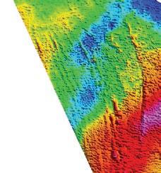
Figure 1: The study was located along the outer continental margin off Nova Scotia. The cartoons illustrate the typical seismic stratigraphy for the area.
geo-reservoirsolutions.com Geo-Reservoir Solutions offers a broad base of seismic interpretation experience as well as a full array of software tools to provide full reservoir characterization and Quantitative Interpretation (Q.I.) of reservoir properties. RokDoc software is utilized to provide highly calibrated results to characterize sub-surface reservoirs. Quantitative i nterpretation services Contact us for more detailed information and find out how we can help you make the best decision. calibrations analysis integration rock physics expertise in Integrated Subsurface Solutions 403.703.8748 interp@geo-reservoirsolutions.com Featuring Interpretation Consulting - offering experience in all technical operations ... RECORDER_GEORes_QuantInt_02_2013.indd 1 2013-02-22 8:27 AM
SOFT SKILLS PRODUCTION
GENERAL GEOSCIENCES
OIL SANDS CARBONATES
CLASTIC
2013 Education Program cSPg ProFESSionaL dEVELoPmEnt 2013 EDUCATION PROGRAM CSPG PROFESSIONAL DEVELOPMENT * + CAD125 for Non-member ** Course listed both under Clastic and Carbonates Latest update: www.cspg.org LocationTitle Authors Nb Days Dates Member Cost (CAD)* Downtown Calgary Networking: Real World & Real Time Connections - Creating Powerful New Circles of Influence Bruce Lee 1d Oct 24 350 LocationTitle Authors Nb Days Dates Member Cost (CAD)* Field Seminar Drilling and Production; a Trip to a Working Drilling Rig and Production Facilities David Hill 1d June 7 550 Downtown Calgary Drilling & Production Fundamentals David Hill 2d Oct 21-22 950 LocationTitle Authors Nb Days Dates Member Cost (CAD)* Field Seminar Geology for non Geologists Jon Noad 1d June 20 350 Downtown Calgary Conflict Resolution within the Realm of Oil & Gas Negotiations David Hill 2d Oct 23- 24 950 Downtown Calgary Fluvial Stratigraphy John Holbrook 2d Oct 23-24 1,050 LocationTitle Authors Nb Days Dates Member Cost (CAD)* Field Seminar Stratigraphy and Hydrocarbon Systems of the Sappington (Bakken/Exshaw) and Three Forks Formations in Western Montana** Ted Doughty George Grader 3d Jul 25-27 1,500 LocationTitle Authors Nb Days Dates Member Cost (CAD)* Field Seminar Contrasting the Reservoirs of Braided and Meandering depositional systems Jon Noad1.5dJune 12 pm-13 540 Field Seminar Tide-Dominated Depositional Environments in the Bay of Fundy, Canada Murray Gingras Shahin Dashtgard 4d June 12-15 2,650 Field Seminar Stratigraphy and Hydrocarbon Systems of the Sappington (Bakken/Exshaw) and Three Forks Formations in Western Montana** Ted Doughty George Grader 3d Jul 25-27 1,500 Field Seminar Subtidal Sandbodies Heterogeneity and Sequence Stratigraphic Distribution in the Gog Group of the Southern Canadian Rockies: Insights for Reservoir Modelling Patricio Desjardins Luis Buatois 3d Sep 4-6 1,775 ERCB Core Mannville Stratigraphy, Sedimentology and Petroleum Geology Doug Cant 3d Oct 16-18 1,775 ERCB Core Subsurface Methods In Clastic Sediments Doug Cant 2d Oct 21-22 1,000 ERCB Core Rock Creek Stratigraphy, Sedimentology and Petroleum Geology Doug Cant 1d Oct 25 625 LocationTitle Authors Nb Days Dates Member Cost (CAD)* Field Seminar SAGD Fundamentals - Field Seminar in Fort McMurray, Alberta R. Strobl, M.Fustic & D.Wightman 2d June 18-19 1,950 Field Seminar Geology of the Athabasca Oil Sands Murray Gingras & Mike Ranger 3d Sep 5-7 3,650 Field Seminar Glacial sedimentology for oil sands geologists Nick Eyles 3d Sep 11-13 1,490 Field Seminar Gironde estuary and Aquitaine
field trip: modern environments and reservoir characterization Hugues Fenies 4d Sep 17-20 3,400
coast
24TH A NNUAL CSPG Mixed Golf Tournament
| By David Middleton and Brenda Pearson, Co-Chairs, CSPG Mixed Golf Tournament
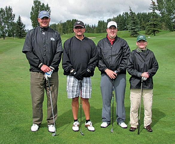
Mark your calendars, and get ready for the 2013 CSPG Mixed Golf tournament on Friday August 23rd at 8am at Lynx Ridge Golf course. We look forward to seeing all of our colleagues from previous years as well as welcoming new golfers. The tourney includes a round of golf, meals, plenty of hospitality and good times, and a chance to network with your colleagues and industry sponsors. The tournament has always benefited from the pleasant August weather (except for last year!), and typically the golf course is at its finest, with the inviting fairways, smooth greens, spectacular mountains and the ever-beckoning water hazards and sand traps to capture errant golf shots.
The tournament is a mixed four person best ball Texas scramble format, so golfers of all levels can participate and contribute to the team’s success while having a great time enjoying the day and the camaraderie of your fellow golfers. Thanks to our sponsors, a plethora of prizes are available for both the skilled and not-so-skilled golfer. We encourage all levels of golfers to join us as the emphasis of the day is on fun!
Please watch for further announcements and information in the CSPG Reservoir, or on-line at the CSPG website www.cspg. org, and make sure to register early to avoid disappointment. Entry fees remain the same as previous years, with members paying only $90 for the event. This year we will be accepting online registrations only.
We would like to thank all our sponsors from 2012 and look forward to the return of members, guests and sponsors to enjoy the event in 2013.
You can address registration inquiries to David Middleton at 403-296-8844 (dmiddleton@suncor.com) or to Brenda Pearson at 403-206-3339 (bpearson@ birchcliffenergy.com)
If you are interested in sponsoring the tournament this year, please contact Darin Brazel at darin.brazel@ihs.com.
AnnuAl
Structur Al Field trip At BArrier lAke,
kA n A n ASkiS countrY the CSPG Structural Geology Division is organizing its annual fall field trip on Saturday, September 21st.
The focus of this one day field trip will be the structural deformation well exposed on the north shores of Barrier Lake. Transport will be organized and optimized using some of the participants’ vehicles. There is no cost associated to the field trip.
If you are interested, please contact Jean-Yves Chatellier at jeanch@usa.net.
RESERVOIR ISSUE 6 • JUNE 2013 11
T HE C AR bONATE L IARS C LU b OF C ALGARy
25 Year Anniversary
| Contributions from Jeff Packard, Bill Martindale, Dave Hills, Alex MacNeil, Jean-Yves Chatellier, and Mark Mallamo
The Carbonate Liars Club of Calgary celebrates its 25th anniversary this year! In case you’re not familiar with the club, it’s a friendly group of “carbonate enthusiasts” that meets once a month (usually the last Monday evening) at the Unicorn Pub on Stephen Avenue to discuss all sorts of matters carbonate related. In addition to socializing, there is usually a speaker (or two) who presents on a topic that they have recently worked on or studied. The group is unique in that despite its informal organization it has managed to carry-on now for 25 years.
The Club was formed in the spring of 1988, and the initial concept was sketched out in conversations between Jeff Packard and Bill Martindale, during the period following the CSPG-sponsored Canadian Reef Inventory Project (1987 Banff Conference and CSPG Memoir 13). Both had been heavily involved in the project, and some of the highlights of the Banff Conference were the informal beer and bull sessions, that were often insightful, provocative and/or just plain fun. Of course most Earth Science conferences stage similar events, but the question they asked themselves was, why wait for a conference or convention to facilitate these more informal exchanges of ideas? Calgary certainly had a critical mass of geoscientists interested in carbonates,


and the other critical ingredient, beer, was a logistical hurdle that could easily be overcome.
There were then, as now, venues for more polished talks. The CSPG had its Technical Luncheons, as well as the Luncheon Talk series hosted by individual Technical Divisions. What Bill and Jeff wanted was a more casual forum, less constrained by time, where questions were as important as answers, and where the material covered in the presentations might range from the ridiculous to the sublime, from observations on some enigmatic features seen in one or two thin sections, to more wide-ranging postulations on carbonate dynamics for particular geological Systems. The meetings would be open to all, from the freshly-minted undergrad to the jaded greybeard. The “Liars” moniker and associated logo reflected the fact that the club didn’t take itself too seriously, and that truth in a science whose hard evidence is typically hundreds of millions of years old (truly cold cases!), and altered after the crime by diagenesis, is a moving target.
The inaugural meeting was held on May 4th 1988 at the Royal Duke Pub, where a healthy number of carbonate types showed up and the basic premise of the club was established. From the outset it
was determined that organization should remain largely haphazard, and that the Club would not affiliate itself with any larger body. It therefore came as quite a shock the next spring, when a request was received from the CSPG to submit our annual report of activities. The request and an invitation to become a part of the CSPG were politely declined!
The first technical meeting was held June 1st in Packard’s basement, with Nigel Watts delivering a presentation on a submersible dive down the Jamaican foreslope. The 25 or so attendees enjoyed the evening, and the Club was off and running. In 1989 the venue for monthly meetings was switched from members’ basements to a more central location downtown, DeSoto’s Pub. In a pattern that was to be often repeated, the Club soon outstayed its welcome and migrated to the Rose & Crown, then to Nathan’s, then Quincy’s and finally to the Unicorn, where meetings are currently held. Long before the days of e-mail, the club relied on a telephone pyramid and fax to get the word out, along with fliers that outlined a half season’s worth of meeting topics. In the early years speaker names were deliberately disguised, to avoid preemptive decisions on attendance based on personality rather than subject.

12 RESERVOIR ISSUE 6 • JUNE 2013
th Annual Unconventional Resources Conference Crea ng Value in an Unconven onal World visit www.csurconference.ca for more details Register by July 5 and SAVE! Oc tober 9-11, 2013 | Calgar y TELUS Convention Centre Canadian Society for Unconventional Resources www.csur.com | e. info@csur.com | p. 403-233-9298 | tf. 1-855-833-9298
Activities in those early days were not restricted to pub discussions, and included field trips, Christmas socials, and Barbeques. In the mid-1990’s John Bladek of Calgary Petrographics kindly provided Liar’s Club golf shirts to members in a flagrant abuse of our strict policy on influence-peddling. Clearly the Club had come of age – we now had our own uniform!
If anything has defined the Club, it has been its members. Carbonates attract more than their fair share of “characters” (could be the beer!), and the Club has had the pleasure of hosting a number of memorable debates and has been honoured with presentations from some very bright and world-renowned folks from the fizzy rock world. But the Liars has proven to be more than just talks from invited speakers. The meetings provide a venue for industry folks to get together and share knowledge and catch up on the state of our industry – carbonate interests ebb and flow with as much volatility as any other hydrocarbon system, plays come in and out of vogue, and old ideas are slowly replaced with new – an informal venue such as the Liars is perfect for monitoring the health of our corner of the world. For new graduates, especially those from out of town, the industry and its players can be quite intimidating. For these folks, the Liars has been the perfect networking vessel. Where else can the budding ‘soon to be available’ geologist have the ears of so many of the right people in one place? And from the other side of the fence, potential employers can be wooed by the technical knowledge and enthusiasm of a recent graduate prepared to give a talk in a pub!
The Club has not always enjoyed calm seas, any more than the industry as a whole, but it seems that each time the boat appeared likely to swamp, a new set of hands has come on deck to steer a more energized and stable course! The Carbonate Liars Club has provided so much more than even Jeff and Bill could have imagined, not just the advancement of our craft, but a central hub for the carbonate community in Calgary. On behalf of friends of carbonate rocks in Calgary and beyond, to Jeff Packard, Bill Martindale, Steve Switzer, Joel Collins, Laurie Slezak, Eileen Scott, Graeme Bloy, Dave Hills, Mark Mallamo, Brent Wignall, Mark Hearn, and most recently Alex MacNeil and Jean-Yves Chatellier, Liar’s coordinators over the years, a sincere thank you for keeping the informal exchange of ideas flowing.
For more information on attending a meeting, interested folks can contact Jean-Yves Chatellier (JChatellier@ talisman-energy.com) and/or Alex MacNeil (amacneil@osumcorp.com). In recent years the club has evolved into a broad group that includes structural geologists, petrophysicists, geophysicists, and yes, even engineers. Newcomers to Calgary and new graduates are especially welcome. Recent
presentations have included carbonaterelated aspects of the Montney Formation, the Zagros fold and thrust belt in Kurdistan, diagenesis and reservoir properties of the Grosmont, the stratigraphy of Silurian carbonates in the Hudson Basin, the origin of Cayman Island dolomites, and the causes of the Triassic-Jurassic extinction (by a 2nd generation Liar!).
the canadian Society of petroleum Geologists (cSpG)
Call for NomiNatioNs to the Board of d irectors 2014
CSPG is a not-for-profit corporation under the NPO Act. In addition, we are governed by our ByLaws. As such, only Full Members may stand for election. The term commences at the Annual General Meeting January 9th, 2014. Nominations for Directors close September 13th, 2013.
CSPG is calling for nominations for executive Committee: President elect - who will serve a total of three (3) years comprised of the first year as President Elect, the second year as President and the third year as Past President.
Finance Director elect - who shall serve a two (2) year term comprised of the first year as Finance Director Elect and the second year as Finance Director.
Directors at l arge
Four Directors– who shall each serve a two (2) year term.
nomination Process
There are two ways candidates can be nominated:
1) nominating Committee Candidates: The Nominating Committee selects candidates for nomination based on candidate qualifications, experience and expertise. The Nominating Committee is accepting referrals for nominations and will meet from June to September to select the candidates it will support for election to the Board and you are encouraged to submit expressions of interest or referrals directly to the Chair of the Nominating Committee, Robin Mann, at rcmann@deloitte.ca All referrals will be contacted to confirm their interest. Referrals must be received by Wednesday July 31st, 2013 at noon. Shortlisted prospective nominees will be requested to provide a completed Nominations Form by Friday August 30th, 2013 at noon.
2) Write- in Candidates: Full Members can submit a nominee with the support of 25 Full Members in good standing to the CSPG Office, attention: Nominations Committee. Written consent of the nominee and the nominee’s completion of the Nomination Form along with the signatures of 25 Full Members in good standing is required. These documents must be received by the CSPG Office no later than Friday, September 13th, 2013 at noon
Forms are available on www.cspg.org or at the office: 110, 333 5th Ave. SW. Calgary, Alberta T2P 3B6.
Forms available on www.cspg.org: Articles of Continuance, NPO Act ByLaws, Code of Conduct, Who is CSPG?, Nominations Form, Information to Candidates.
RESERVOIR ISSUE 6 • JUNE 2013 13
ROCK SHOP


14 RESERVOIR ISSUE 6 • JUNE 2013
petrographical & sedimentological descriptions for samples (thin section - fluid inclusion studies) conventional vertical/horizontal wells operations geology SPECIALIZED IN GEOLOGICAL WELLSITE SUPERVISION AND CORE ANALYSIS
our best friend and most valuable partner is our client Stephan C. Dragomir president www .g e ok2. c om - phon e : 403.831.9941 - s dr a gomir @ g e ok2. c o m 1602 – 5th St N.E. Calgary, AB. T2E 7W3 Phone: 403-233-7729 www.tihconsulting.com e-mail: tih@shaw.ca T.I.H. Consulting Ltd. Geologic Well-Site Supervision *Domestic & International Supervision 906, 505 6 St. SW Calgary, AB T2P-1X5 Jocelyn Lampron, P. Geol. President & CEO Wellsite Geological Supervision *Conventional Wells-Heavy Oil/SAGD *Coal Bed Methane Wells www.hopewellpetroleum.com info@hopewellpetroleum.com section ph: 403.266.3132 cell: 403.818.8549 *On & Offshore Geological Supervision Opus Training Group 403 720-9810 www.opustraininggroup.com Geology Training for the Petroleum Industry Wellsite 101 (The name that says it all!!!) Bus 403.234.7625 800, 555 - 4 th Avenue SW, Calgary, AB, T2P 3E7 info@WellsiteGeologists.com www.WellsiteGeologists.com
RockWell Consulting
C LARIF y ING DATAROOM C ONFUSION
| By J. Douglas Uffen P. Geoph (APEGA), P. Geo (APEGBC), President and Managing Partner, Geo-Reservoir Solutions Ltd.
INTRODUCTION
Geophysical datarooms are an important element of business in the resource industry. They are staged for many reasons such as: when a company undertakes a sale process of assets or properties, during a Show and Tell presentation, or a farm-in process to attract new investors. Confidentiality Agreements (CAs) are often put in place to protect the data and competitive information of the disclosing party. The geophysical dataroom is often appended to the primary business activity at hand. As such, it may often be handled separately in another meeting, is implemented with a variety of nonstandard procedures across industry, and may involve a broad mix of entities. Those involved in the dataroom can vary from internal land departments, internal exploration / development business groups, third party property divestiture houses, third party consulting houses, financial institutions, and investment houses. Over the years, an informed geophysical person has not always been involved in the process, leaving the opportunity for inadvertent poor practices to evolve and become entrenched in industry.
In May of 2010, APEGA published a guideline entitled, “The Ethical Use of Geophysical Data” in an effort to assist professional members in dealing with the use of licensed geophysical data within the oil and gas industry (APEGA, 2010). The document was general in nature, but it did provide a few scenarios as examples in an effort to give context regarding what constituted ethical behaviour. However, of particular interest to APEGA members are what activities can or cannot be done in a dataroom. In turn, how does one go about setting up a dataroom in compliance with the APEGA guideline? The purpose of this article is to focus on the specific subject of datarooms.
bACKGROUND ON DATA
Ow NERSHIP, COMPETITION, AND APPLICA bLE LAw.
The original stakeholders who acquire the geophysical data are said to possess the “trading rights” to the data, much akin to an author holding the copyright or ownership to a book. Multiple parties could be involved in the original field operation, often tied together only with an AFE (Authority For Expenditure) document. This document
may become the sole record denoting who the original participants in the geophysical data acquisition were. Hence, adequate management of data records is vital to prevent the potential loss of this historical record and to identify what data sets possess what ownership classification. Data of varying data ownership classes possess different privileges. The greatest freedoms are associated with 100% ownership of proprietary data because it involves only one entity. In this scenario, any harm created by offering the geophysical data to another third party is solely related to the entity making the decision. With partnered data, there is another entity to consider. Licensed data, speculative survey data and participation survey data all have license agreements, subject to varying terms, obligations and conditions. Keeping track of data ownership classes and the ensuing agreements that govern them, such as Joint Venture (JV) agreements, and AMI (Area of Mutual Interest) agreements, is a vital precursor to identifying what geophysical data could be used to stage a dataroom.
Within industry, seismic data is an asset which can be bought and sold. The data can be sold by one of two methods. Most commonly, a license to the data can be granted by the original acquirers of the data by means of a license agreement. The license may disclose terms or conditions with respect to the ongoing protection of the confidential nature of the data and its use by the licensee. Hence, once again, suitable records management practices are required to keep track of this important documentation. It is industry standard practice for any geophysical data to be released for potential sale that unanimous stakeholder approval be granted. Any one party possessing the trading rights, regardless of their working interest, can prevent the data from being released for sale. This is related to the fact that geophysical data is often thought to be confidential information that offers a competitive advantage regarding the potential acreage involved to the party that possesses the data. When dealing with seismic data one needs to understand the common law (including how it applies to contracts), applicable legislated law such as copyright law, and the laws governing confidential information (Hunt et al, 2012). These aspects of law are in place to protect the competitive interests of all
parties involved, including the data owners. Some third party seismic data licensing agreements can be quite liberal regarding the use of the data by the licensee while other agreements can be quite restrictive. These difference in licenses, and the uses they allow, often become relevant when dealing with a geophysical dataroom scenario. Knowing what privileges a license permits is essential for setting up a dataroom as license agreements are not standardized across industry between vendors and have often changed over the years by the same vendor.
The second method to convey ownership of the data is to sell the trading rights possessed by the original acquirer(s) of the data. Working interest entitlements cannot be subdivided in order to accomplish this. For instance, if two parties owned a dataset equally with a fifty (50%) working interest, one party could not “cut-in” an additional third party by reducing their interest to 25% and granting 25% ownership to the third party without the consent of the other 50% partial owner because this creates a third entity who would be entitled to the data. Due to the confidential nature of geophysical data, the first partner possesses the right and ability to have a say in the creation of a third license. Within industry, trading rights can be sold without the consent by a partner in the dataset, but this can only be accomplished by “stripping” the previous partnered owner of all instances of the data so as to ensure that a new license is not created. “Stripping” an entity of all instances of the data does not stop at just simply removing it from a storage house, but removing it from the interpretive workstations, map racks and all other instances of occurrence. For datasets that have permeated an organization for years, this becomes an almost impossible task hence these deals occur much less frequently due to the nature of this obligation. They are often restricted to 100% proprietary data transactions only.
SETTING U P A DATAROOM
One of the first aspects to consider is to determine what classes of data would be involved in a dataroom. If 100% proprietary data is involved, the host company may choose to permit a review of the data along with their accompanying
(Continued on page 16 ...)
RESERVOIR ISSUE 6 • JUNE 2013 15
interpretation or they may wish to permit the act of interpretation. Interpretation is the “process of deriving a geological model or concept from geophysical data.” It includes the creation of derived products by measurements made on processed data and the maps and other displays made from the data. It also includes conclusions or inferences made by the interpreter, such as geologic edges or fluid contacts (APEGA, 2010). A review of an existing interpretation is a general assessment of the information as presented, without active manipulation of geophysical data.
If third party licensed data is placed in a dataroom, the act most likely to be permitted is that of a review rather than an interpretation. This is also true for partnered data, but sometimes the partner will permit the act of interpretation if so asked. Regardless of whether the act of interpretation or a review is permitted, maintaining Direct Control of a dataroom environment is paramount. Direct Control is the ability to prevent copying or other unauthorized use of a licensor’s data (APEGA, 2010). Direct Control can be exercised in numerous ways, sometimes employing multiple methods simultaneously.

Read only workstation access can be granted that restricts the visiting party from conducting an interpretation, even if they tried. The USB ports can be disconnected, thereby preventing any copying or loss of the data and the ensuing interpretation. A “babysitter” who monitors the visiting party activities or who actively drives the workstation for the attendee is another way to maintain Direct Control. It is the obligation of the hosting party of a dataroom to make sure that third party licensors or partners are not harmed in any way. This obligation does not extend just to the professionals licensed by APEGA, but the companies that possess a permit to practice from APEGA. When acting on behalf of a company disclosing geophysical data, a professional member is obligated to advise any visitors about their requirement to comply with applicable licenses.
Based upon ownership classifications and any license agreements, one of the first decisions to make is whether the dataroom will have an interpretive approach or a review only approach. License agreements need to be checked to make sure that the data being placed in the dataroom environment is permitted to be there. One should also check to see if there are any Area of Mutual Interest (AMI) documents, Joint Venture (JV) documents or other partner agreements that prevent the data from being viewed by other third parties. Many properties being sold in a divestiture process have not been worked on for years. It is prudent to access the most recent workstation project(s) and clean up the interpretations to tell a uniform story. Nothing is more frustrating for the dataroom attendee than to try to sift through years of history on a project to discern what horizons have been uniformly interpreted over the project area. An interpretive “clean-up” is often a good investment of time and money. After all, don’t you wash and wax your car before you try to sell it? Companies with limited resources may find this an onerous task. Options exist for companies experienced in dataroom set up, to “clean-up” existing interpretations prior to staging a dataroom.
ATTENDING A DATAROOM
Visitors to a dataroom are obligated to inquire about the ownership status of the data in order to guide their own conduct. “When geophysical data, information and knowledge derived from the data is being disclosed, all professional members must be aware of their professional responsibilities. Professionals must be aware of and honor any restrictions associated with the
16 RESERVOIR ISSUE 6 • JUNE 2013
(...Continued from page 15) Quality Multi-clientData
disclosure of the data” (APEGA 2010). Before knowingly interpreting any third party trade data, the visitor must have the data owner’s consent or have acted with diligence in determining that such activity is specifically provided for in the license agreement.
wHAT I S A PPROPRIATE C ONDUCT
In a dataroom environment, none of the data may be removed or copied. Sketches, notes and diagrams may be made but nothing can constitute a tracing of an image on the screen. The hand drawn diagrams cannot make reference to any measurable numbers derived from the data itself. The taking of a camera image via a cell phone camera or any recording device is strictly forbidden. Some datarooms may even request that cell phones or any electronic device that contains a camera be surrendered in advance of entering a dataroom. If the dataroom is set up as a review only option, the attending party and professional are obligated to conduct themselves accordingly.
SUMMAR y
Companies are allowed to make use of their geophysical data to facilitate their business. They are not allowed to harm a
third party in the process. The creation of a geophysical dataroom can be a worthwhile exercise to showcase the upside potential of the assets being sold or divested. Care must be taken that the dataroom be set up in compliance to the APEGA guidelines and any third party license agreements of partner agreements. The type or style of dataroom must be considered along with what action (interpretation or a review) will be allowed in a dataroom setting. Taking a bit of time and effort to clean-up the project can add considerable value to the sale or divestiture process.
ACKNOw LEDGEMENTS
I wish to recognize and thank Doug Pruden P. Geoph. (APEGA) and Lee Hunt P. Geoph. (APEGA) for their contributions associated with editing this article.
About the Author: Doug Uffen P.Geoph (APEGA), P. Geo (APEGBC) is the President and Managing Partner of a consultancy called, Geo-Reservoir Solutions Ltd. He is a seismic interpreter with over 30 years of experience. Doug has extensive experience and knowledge with respect to seismic licensing issues and dataroom conduct. Doug teaches a course to industry which focuses upon the rules associated with various
classifications of seismic data ownership in different business situations. He was also a member of the APEGA committee that created the guideline document regarding the ethical use of geophysical data. He is a Past President of the Canadian Society of Exploration Geophysicists (CSEG) and is a member of APEGGA, APEGBC, CSEG, SEG, EAGE and the Calgary Petroleum Club.
R EFERENCES
Guideline for Ethical Use of Geophysical Data, V1.0, May 2010, APEGGA. http:// www.apegga.org/pdf/Guidelines/ EthicalUseOfGeophysicalData.pdf
Hunt, L., B. Palmiere, H. den Boer, J. Boyd, M. Sykes, D. Uffen, C. Welsh, 2012, A Practical perspective on APEGGA’s Guideline for Ethical Use of Geophysical Data: CSEG Convention Abstracts, 1-4.
Geoscience Consulting | Multi-Client Studies | Information Products | Completions &
Frac Data

Discover how our unique blend of geology, geophysics and

RESERVOIR ISSUE 6 • JUNE 2013 17 Canadian Di scover y Lt d. T 403.269.3644 E info@canadiandiscovery.com www.canadiandiscovery.com
provides fully-integrated solutions for subsurface characterization.
geomechanics
GO TAKE A HIKE Brewer Creek Headwaters, Purcell Mountains, B.C.
| By Kevin Root
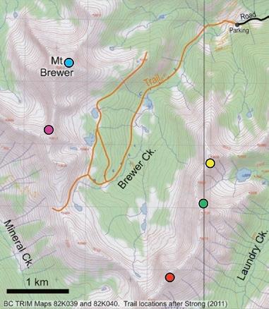

trailhead: Proceed 18 km south of Invermere, BC on the West Side Road (west of Lake Windermere), turn west onto Hawke Road, and drive approximately 28 km to the trailhead at 1900 m elevation. The last 2.5 km requires a high clearance vehicle. Road conditions may vary from year to year. See the excellent Cameron and Gunn (1998) and Strong (2011) books for more details about access and trip options.
destinations: Various opportunities exist for day or overnight trips to several lakes located near the tree-line, at 2270-2450 m elevation, or for hikes and scrambles to the summit of Mount Brewer (2812 m) or other lower peaks and ridges in the area. Route-finding skills are necessary, especially if venturing off of the trails.
The Alpine region at the headwaters of Brewer Creek is an easily accessed destination for day hikes or multi-day trips. This area provides a delightful mix of old growth forests, alpine meadows and small alpine lakes, and is surrounded by rugged peaks made up of Proterozoic sedimentary rocks of, in ascending order, the Dutch Creek, Mount Nelson and Toby Formations. Although the region has none of the >3000 m peaks or glaciers that are present in other popular areas within the Purcell Mountains, the area has a unique beauty and charm of its own.
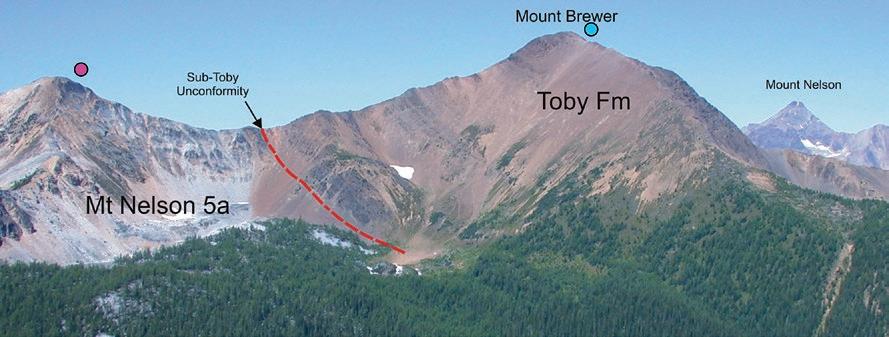
Mount Brewer is noteworthy in a geological context because of the beautifully exposed outcrops of the Neoproterozoic (±700 Ma) Toby Formation (basal Windermere Supergroup) on its slopes. The Toby at Mount Brewer consists mostly of diamictite – poorly sorted pebble, cobble and boulder conglomerate, with minor sandstone and mudstone layers. Some clasts are faceted and striated, which suggests a glaciogenic influence. The Toby is apparently correlative with other similar strata in various locations around the world, and the succession has been interpreted to have been deposited during one of two or more Neoproterozoic ‘Snowball Earth’ glacial episodes, when the earth is interpreted to have been completely or nearly completely frozen over (Hoffman et al., 1998). Alternatively, the Neoproterozoic diamictites have been interpreted to be the product of rift tectonics during supercontinent breakup, with limited contributions of glacial sediments derived from local glaciated topographic highlands (Eyles and Janusczak, 2004).
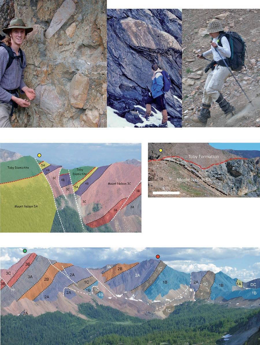
Seismic-scale extensional and possible strike-slip faults are present in the Brewer Creek area. Abrupt changes in the erosion level below the sub-Toby unconformtiy across some of the faults indicates that they formed during the Neoproterozoic, during the rifting event that lead to the development of the ancient Cordilleran continental margin along the western edge of North America.
reFerences:
Cameron, A. and Gunn, M., Hikes around Invermere. Rocky Mountain Books, 209 p. Eyles, N.; Januszczak, N., 2004, Zipper-rift: A tectonic model for Neoproterozoic glaciations during the breakup of Rodinia after 750 Ma. Earth-Science Reviews, v. 65, p. 1-73. Hoffman, P. F.; Kaufman, A. J.; Halverson, G. P.; Schrag, D. P., 1988, A Neoproterozoic Snowball Earth. Science, v. 281, p. 1342-1346.
Strong, J., 2011, Mountain Footsteps – Hikes in the East Kootenay of Southeastern British Columbia. Rocky Mountain Books, 286 p.
Background Photo by Astrid Arts.
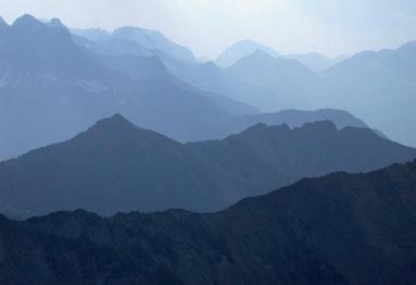
View to the northwest from the south ridge of Mount Brewer.
18 RESERVOIR ISSUE 6 • JUNE 2013
View to the NW of the 5a (Upper Quartzite) member of the Mount Nelson Formation unconformably overlain by Toby Formation diamictite on Mount Brewer. Width of view is approximately 2.3 km.

 Typical Toby Formation diamictite, Toby Creek area, 12km to the northeast of Mount Brewer.
Large boulder in Toby Formation, Delphine Creek, 15 km to the north of Mount Brewer. Scree running on the south-eastern slopes of Mount Brewer.
View to the southeast, on the ridge between Brewer Creek and Laundry Creek, of faults (white lines) that cut the Mount Nelson Formation and the Toby Formation. Variations in the erosion level below the sub-Toby unconformity (red lines) indicate the faults were active during the Neoproterozoic. Width of view is approximately 700 m.
Sub-Toby angular unconformity (red line), Brewer-Laundry ridge.
Typical Toby Formation diamictite, Toby Creek area, 12km to the northeast of Mount Brewer.
Large boulder in Toby Formation, Delphine Creek, 15 km to the north of Mount Brewer. Scree running on the south-eastern slopes of Mount Brewer.
View to the southeast, on the ridge between Brewer Creek and Laundry Creek, of faults (white lines) that cut the Mount Nelson Formation and the Toby Formation. Variations in the erosion level below the sub-Toby unconformity (red lines) indicate the faults were active during the Neoproterozoic. Width of view is approximately 700 m.
Sub-Toby angular unconformity (red line), Brewer-Laundry ridge.
RESERVOIR ISSUE 6 • JUNE 2013 19
Proterozoic Mount Nelson Formation strata (members 1A to 3C ) are cut by extensional faults (white lines) on the ridge between Brewer Creek and Laundry Creek. DC: Dutch Creek Formation. Width of view is approximately 2.5 km.
ROCK SHOP

Reservoir Geomodeling Reservoir Simulation Integrated Study
Julee Lee (403) 554-3957, Helen Cao (403) 968-6268, Gary Selby (403) 818-1594
jlee@petrosteer com, hcao@petrosteer com, gselby@petrosteer com


20 RESERVOIR ISSUE 6 • JUNE 2013 Strip Log Strip Log Horizontal Log Horizontal Log Mud Log Mud Log Log Viewer Log Viewer Log Manager Log Manager Log Analysis Log Analysis Suite 102, 7370 Sierra Morena Blvd SW, Calgary, AB T3H 4H9 info@WellSight.com 1-800-447-1534 (403) 237-9189
Excellence in Geological Services for Over 20 Years Integrated Reservoir Studies for All Resource Types 4D Geomodelling & Geosteering Horizontal Well Path Planning Infill Well Placement Studies SMART4D Modelling ® Software www.uogc.com 403.265.0111 91 0 , 396 11th Ave SW C a lgar y, AB Cana da CONSULTANTSINC. WELLSITE GEOLOGICAL SUPERVISION Fax403 264 1262 Cell403 819 2516 farhat@sableconsultants.com SABLECONSULTANTS.COM Conventional Wells Coring Programs Heavy Oil/Oil Sands Coal Bed Methane SAGD Horizontal Project Supervision www.rpsgroup.com/energy (403)263-0449 17084 Global Leaders in Wellsite Geology Serving the petroleum industry for over 25 years ■■ Conventional Vertical / Horizontal Wells ■■ Unconventional Heavy Oil / CBM Wells ■■ International WSG / Operations Geology • Domestic and International wellsite supervision • Conventional and Unconventional wells • Extensive Hz experience • Customized corporate solutions available (403) 250-3982 sales@clconsultants.ca www.clconsultants.ca 油田投资项目咨询 油田收购评估 油气田勘探开发技术支持
www.petrosteer.com 贝 特 斯 亚 海 外 石 油 研 究 中 心 Conventional Wells • Horizontal Wells - Spearfish - Viking - Bakken - Cardium - Horn River Shale Gas Email: afran@telusplanet.net www.serpaconsulting.com
A DVANCED MUD G AS AND ROCK-FLUID Analysis Aids Evaluation of North American Unconventional Plays
|
By Don Hall, Michael Sterner, and Rohit Shukla
Although unconventional oil and gas plays are highly variable in terms of geology, geochemistry and structure, many of the key factors within these disciplines are repetitively quoted as influencing successful exploitation. These include:
1. Composition and quality of the in situ petroleum fluid(s),
2. Controls on distribution and volume of petroleum, both geographically and within a given borehole,
3. Water saturation and potential for internal or external water production,
4. Rock type and mineralogical composition for log calculations, lateral location and completion optimization,
5. Natural fracture distribution and porosity types,
6. Compartmentalization, sealing and natural interconnectivity, and
7. Relative proportions of locally generated and migrated petroleum.
These and other aspects of these complex systems can be evaluated before, during or even instead of expensive logging programs using the unavoidable byproducts of the drilling process: namely, borehole gas and drill cuttings. Industry perception of the value of these has waxed and waned over the years, in part due to variable data quality as well as cost. However, use of more advanced geochemical techniques is enjoying resurgence, in part due to evolution of field instrumentation and more reliable analytical techniques, and is paying dividends for those companies that elect to implement them in routine evaluation of unconventional plays. Of these, the complementary combination of advanced mud gas analysis in the field using gas-chromatography (GC), mass spectrometry (MS) or GC coupled with MS, and comprehensive cuttings analysis for trapped fluids and organic and inorganic makeup in the lab is the most promising. As many unconventional resources have a significant number of historical vertical penetrations, rock-fluid databases can be established rapidly and cost-effectively at an early stage without drilling new wells.
A DVANCED M UD G AS A NALy SIS: Recent developments in application of membrane-GC, GCMS and direct
MS analysis to mud gas, along with improvements in mud gas extraction instrumentation and techniques (e.g., constant volume, constant temperature, gas-in and gas-out arrangements) provide data sets that are light years ahead of historical Hot-Wire/GC methods. Of these new techniques, direct quadrupole mass spectrometry (DQMS) is by far the most comprehensive, sensitive and flexible tool for compositional evaluation of formation fluids in near real time. DQMS evaluates C1-C10 petroleum species, and inorganic compounds such as carbon dioxide, helium, hydrogen, atmospherics and sulphur-bearing volatiles. It can discriminate among the major classes of volatile organic compounds (paraffins, naphthenes, aromatics) as well as contributions from the drilling fluid. Evaluation of such a broad range of chemical compounds allows for unsurpassed chemical fingerprinting. Additionally, a number of inorganic/organic species combinations are indicative of specific subsurface processes. The instrument is uniquely suited for organicbase mud systems, which typically hamper data analysis from other devices, and works in low-pressure reservoirs where conventional gear is ineffective. Within unconventional plays DQMS has been used to distinguish among producible hydrocarbon fluid types, identify lower quality or residual systems, evaluate potential for water production,
assess compartmentalization, and recognize fractures and faults. These data have been used to optimize completions for less costly and better producing wells allowing some operators to rethink and minimize logging runs. Monitoring drilling-generated hydrogen can serve as an early warning for bit wear, failing down hole motors and general friction in the drill string. This specific application has tangibly contributed to lower drilling costs, where utilized.
COMPREHENSIVE CUTTINGS
E LEMENTAL -F LUID A NALy SIS:
A new procedure for cuttings or core analysis in the lab has been developed during which the rock is first photographed under visible and UV light, then crushed and analyzed for included hydrocarbon and non-hydrocarbon species with a sensitive mass spectrometry system, and finally probed for its elemental composition with a customized XRF analyzer. A key aspect of the process is that all analyses are conducted on the same 1 gm rock sample with an automated system, thus preserving interrelationships among rock type, fluid type and rock chemistry. Automation and rapid analytical cycles allow collection of large data sets, and encourages analysis of entire wellbores from first returns to TD. Individually the techniques are useful.
(Continued on page 22...)
RESERVOIR ISSUE 6 • JUNE 2013 21
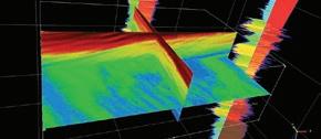
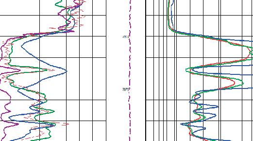
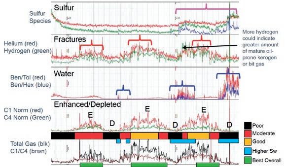
Figure 1: Direct quadrupole mass spectrometry of organic and inorganic volatile species for completion considerations.
(...Continued from page 21)
Together they provide unique insights into controls on hydrocarbon, reservoir and pay distribution, represent an additional tool for well placement, and create an archive of rock type, fluid and rock chemistry information that is easily retrieved and studied in the context of future wells, even in the absence of the original rock material. Of interest is that these analyses can be performed on historical samples of any age, drilled with any mud/bit type.
Cuttings volatile data are used for a variety of purposes, but the most practical applications to unconventional reservoirs are ultimately aimed at predicting fluid type, composition, quality and volume in tight rock, as well as identifying variability along laterals that can be exploited for more effective completions. XRF data from 30+ major, minor and trace elements in large cuttings sample sets from vertical and horizontal wells can be used to document lithology and cements, produce chemical stratigraphic profiles in otherwise monotonous sections, establish depositional environments, facies and provenance, and provide some information relevant to rock
behavior during completion activities. Type
profiles through vertical penetrations can be used to help optimize lateral placement and retrospectively establish borehole trajectory in horizontal wells. Finally, white light and UV images provide grain scale details that can be correlated with other data sets to provide a more integrated understanding of what is controlling hydrocarbon and porosity distribution in the system as well as general formation recognition, evaluation of cuttings quality (and implied drilling conditions), and presence of additives that may affect other analyses. UV images indicate specific mineral or kerogen fluorescence that can be correlated with cement or rock types that are difficult to recognize under white light. Kerogen fluorescence colour can be related to maturity. Archived images are much easier to manage than the samples themselves; they persist when samples are no longer available and allow geologists to look at the rocks at their desks without relying on sample descriptions or lower quality images from well site.
DQMS TO A ID COMPLETION:
Figure 1 illustrates selected DQMS data from a horizontal wellbore within shale. Three main gas bearing zones are documented as is illustrated by the Total Gas, Helium, C1 Norm and C4 Norm curves (red brackets, “E” intervals, red and orange bars). The most producible portions of the well, based on gas volume and porosity, are indicated where helium is high and separation is recorded between the C1 Norm and C4 Norm curves as a result
22 RESERVOIR ISSUE 6 • JUNE 2013
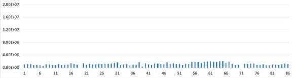
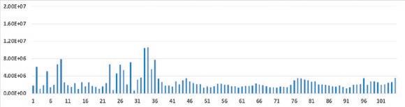
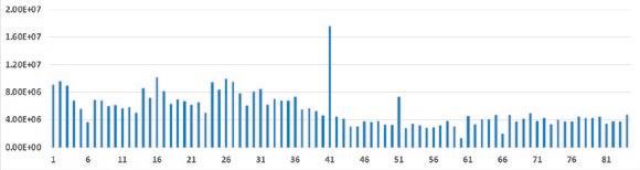
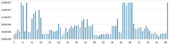
Figure 2: FIS methane response vs sample number, four geographically proximal horizontal wells.
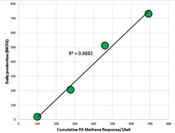
Figure 3: Summed Cuttings Methane Response vs Daily Production; Four Horizontal Wells.
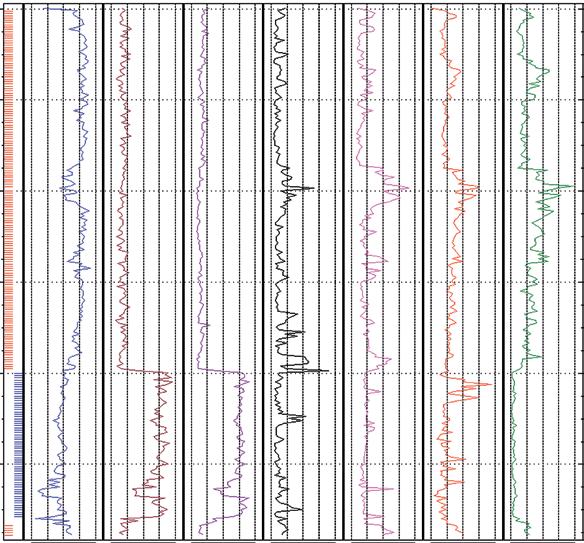
of natural chromatographic separation of light species in tight rock. In other words, the fractured or otherwise more porous sections of the reservoir concentrate the mobile species, which are weighted toward small molecules like methane and helium. These zones are referred to as “enhanced”, while “depleted” zones occur where light/ heavy ratios are low (labeled “D” in Fig. 1). Among other possibilities, depleted zones may indicate that charge has been dissipated via through-going fractures. The toe of the wellbore contains higher concentrations of sulphur species which may represent an undesirable component of the produced fluid, known to be present in this particular area (pink bracket). Of equal interest is the distribution of water, which is indicated by the ratios of benzene to toluene and benzene to hexane (blue brackets and bars).
These increase in elevated water saturation intervals, because benzene is more soluble in water than both toluene and hexane. Considering all of these data allows one to evaluate the most prospective portions of the lateral based on gas composition, gas quality, deliverability and potential for water production. These are indicated by the green bars at the bottom of the diagram. Availability of this extensive data set based solely on mud gas represents a dramatic improvement over conventional approaches, and is particularly valuable in horizontal wells where log suites are minimal.
FIS FOR E ARLy PREDICTION OF PRODUCTION:
A simple example of using cuttings volatile analysis to anticipate and rank eventual production in unconventional reservoirs
is shown in Figures 2 and 3. In Figure 2, cuttings methane concentrations (calibrated millivolt responses from the mass spectrometer) from four horizontal wells within a geographically restricted region are shown as a function of sample number. Data suggest the wells are diverse, both in terms of average response as well as variability through the lateral. Figure 3 illustrates the summed FIS response (divided by 10e6 for convenience) vs. average stabilized daily production over a two month period. Clearly the eventual relative production from these wells could have been anticipated immediately after drilling, and actual production statistics from future wells in the area can be reasonably predicted from this calibration set. Furthermore, contributions to the total production from specific portions of the wellbore can be ascertained, which might influence completion strategies. For instance, approximately 23% of the produced gas from well 4 appears to originate from a single, contiguous 200 ft. measured depth section of the 2600 ft. lateral, and approximately 50% of the gas is generated from 600 ft. or 23% of the horizontal section. Finally, measurement of the intrinsic gas content of the samples distinguishes between wells that have been damaged or improperly completed from those that were drilled in a gas-poor section of rock.
FIS AND XRF FOR TARGETING Sw EET SPOTS:
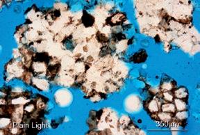
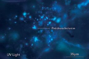
An example of combining XRF and FIS data to identify and understand sweet spots is illustrated in Figure 4, a horizontal wellbore through a light oil /condensate bearing section of the Cardium Sandstone, Alberta. This well encountered an unexpected down-faulted section causing the borehole trajectory to intersect the overlying shale. The borehole was redirected into the underlying sand near the end of the well. These lithological relationships are identified by the red (sand) and blue (shale) tick marks on the left hand side of the figure, which correlate with discrete zones on a silicon vs. aluminum cross plot. The orange bands represent duplicate sections at the top of the sand, and have substantially similar chemical and volatile response. The red band illustrates dry gas within the shale, possibly related to fracturing in the vicinity of the shale and introduction of more mature gas from deeper in the system. Of particular interest is the correlation of the highest FIS gas and oil response with decreased silicon and increased calcium and iron shown by the green band. Petrographic work on cuttings indicates that this zone is
(Continued on page 24...)
RESERVOIR ISSUE 6 • JUNE 2013 23
SS SH Si al K Ca Fe Gas oil
Figure 4: Best production in this horizontal Cardium well (green) correlates with siderite associated porosity, and high light oil inclusion abundance.
Fault
(...Continued from page 23 )
characterized by siderite-enhanced porosity (yellow arrows lower left image), and higher visual light oil / condensate inclusion abundance (blue fluorescing areas, lower right image). The green zone was tested separately and displayed the highest initial rates in the well. Use of this combined rock and fluid approach on vertical wells can be used to more successfully place laterals.
PUTTING IT ALL T OGETHER :
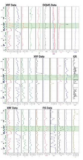
An example that utilizes both DQMS data and advanced cuttings analysis is presented in Figures 5-6. The following discussion concentrates on an interval at approximately 8960-9110 ft. This zone displays a prominent DQMS anomaly characterized by C1-C7 species and gas ratios that suggest light oil or condensate (Fig. 5; Panel A). A slightly drier anomaly occurs within a restricted zone and may represent a discrete gassier phase (or gas and oil) as suggested by FIS data described in a subsequent paragraph. Water-saturation indicators (e.g., benzene/ toluene and benzene/cyclo-hexane) suggest trace movable water within this section, and presence of the sulphur species CS2 and COS suggests that sulphur bearing volatiles may be produced. Trace CO2 is present as well, particularly in the thin drier gas or mixed gas-oil interval.
XRF elemental data and element ratios (Fig. 5; Panel B) indicate that the main zone of interest is a mixed siliciclastic and carbonate (dolomite and limestone) section with both biogenic and terrestrially derived silica (chert and detrital quartz, respectively). Petrographically, the interval is dominated by fractured, cherty carbonate. Aluminum, potassium and iron distribution in part reflect clay components, and the species molybdenum, arsenic, zinc and sulphur are potentially indicative of anoxia and the presence of organic matter. The gamma ray correlates fairly well with sulphur, given the differences in sample spacing, consistent with the above interpretation. Petrographic observations indicate the presence of mature oil-prone source rock in some samples. Phosphorus is present, in this case related to the presence of apatite, and is potentially indicative of near-shore upwelling environments with high surface productivity. Arsenic is also generally associated with nutrient rich depositional environments. Mineralogical trends were verified independently via QEMSCAN. This technique creates a mineral composition map of a petrographic thin section using a rastering SEM based EDS-XRF system and software (Fig. 6).
FIS data (Fig. 5; Panel C) indicate species to C11-C12 with bulk mass spectra that resemble light oil. Upper moderate gravity light oil inclusions are abundant in chert, indicating high petroleum saturation. Some
gas-condensate is noted as well, suggesting the possibility of a dual phase reservoir and consistent with DQMS observations above. FIS C1 and C7 relationship imply two discrete charges (oil and drier gas). Sulphur species are present in FIS data, as previously described for mud gas data, suggesting that some sulphur species (and minor CO2 ) may be produced from this zone. These species are interpreted to be of high temperature origin, and related to dry gas interpreted to have migrated into the structure from deeper in the basin.
The combination of advanced mud gas analysis by DQMS and advanced cuttings analysis via integrated FIS, XRF and photography provides valuable and otherwise unobtainable information with broad application to petroleum exploration and development. Data can be used to help understand the key aspects of conventional and unconventional reservoirs that most commonly contribute to successful exploitation, and can aid in optimizing wellbores and completions to lower costs and allow for more efficient drilling campaigns.
24 RESERVOIR ISSUE 6 • JUNE 2013
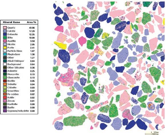
Figure 6: QEMSCAN results from a liquid rich fractured cherty carbonate play.
Figure 5: Combined DQMS-XRF-FIS in a liquid rich fractured cherty carbonate play.
PHOTO OF THE MONTH
RESERVOIR ISSUE 6 • JUNE 2013 25
From the summit of Cirque Peak, Banff National Park. Photo by Sadeed Hassan.
M EDAL OF M ERIT 2012 Formal Citation
The Canadian Society of Petroleum Geologists Medal of Merit is awarded annually for the “best paper related to Canadian petroleum geology” (as specified in CSPG bylaws) published during the previous publication year, in this case for peer reviewed papers published in 2011. The paper chosen this year was written by Milovan Fustic, Barry Bennett, Jennifer Adams, Haiping Huang, Bill MacFarlane, Dale A. Leckie, and Steve Larter and is entitled “Bitumen and heavy oil geochemistry: a tool for distinguishing barriers from baffles in oil sands reservoirs.” The paper was published in the December 2011 Bulletin of Canadian Petroleum Geology, v. 59, p. 295-316.
This paper describes the integration of sedimentologic information and bitumen geochemical data to distinguish between or identify barriers and baffles to fluid flow. Identification and assessment of the lateral extent of inclined heterolithic stratification (IHS) and other low permeability deposits within oil sands is very challenging. Their quantification is critical for the success of in situ oil sands development.
The study area is located in the oil sands south of Fort McMurray. The McMurray Formation reservoir is being developed using steam assisted gravity drainage (SAGD) and consists of three stacked meandering channel belt deposits. Using core bitumen samples from above and below siltstone intervals, viscosities and concentrations of selected aromatic hydrocarbons susceptible to biodegradation were determined. Vertical continuity of the profiles indicates that the silt is a baffle, whereas a shift in the profile indicates that the silt is a barrier.
This work is an important contribution as it presents another tool which can be utilized in planning and optimizing ongoing oil sands development in the McMurray Formation and other oil sands reservoirs in western Canada and in other basins. In addition, the paper is very well written and illustrated, and effectively integrates data from multiple sources.
bIOGRAPHIES
Milovan Fustic is a principal research geologist at Statoil Canada Ltd., in Calgary. He worked in the petroleum and mining industries in Serbia and Canada for 7 years
before beginning to work on various aspects of the oil sands (including sedimentology, geochemistry and reservoir modelling) in 2000. Fustic received a BSc honors degree in geology from the University of Belgrade (Serbia) and a PhD in petroleum geology from the University of Calgary. He has published more than 20 peer reviewed papers and is an instructor for CSPG and AAPG short courses and field seminars related to heavy oil geology, and a volunteer reviewer for AAPG Bulletin and Elsevier’s earth science publications.
Barry Bennett was educated at the University of Aston in Birmingham (BSc Geology 1986), University of Newcastle upon Tyne (MSc Organic petrology and Organic Geochemistry, 1987) and University of Bristol (PhD Organic Geochemistry, 1991). He has 25 years research experience in petroleum geology, geochemistry and analytical chemistry. Barry is currently the Director of Geoscience and Technology at Gushor Inc. and an adjunct professor at the University of Calgary. Barry is a member of APEGA and is an associate editor of the Journal of Marine and Petroleum Geology and the Bulletin of Canadian Petroleum Geology.

Jennifer Adams is an organic geochemist in Geological Technology with ConocoPhillips Houston performing reservoir and exploration scale geochemistry and basin modeling worldwide. In addition, she has worked geochemistry projects in many fingerprinting studies related to spills and casing failures. Currently with ConocoPhillips since 2009, Jennifer has prior experience in CO2 sequestration, basinal fluid property measurement and prediction with the Alberta Geological Survey and petroleum biodegradation in heavy oil fields and Gushor Inc. Jennifer holds a PhD degree in organic geochemistry from the University of Calgary, a MSc in hydrogeology from the University of Alberta & a BSc in Geology from the University of Waterloo.

Haiping Huang obtained his MSc in Petroleum Geology (1988) from China University of Geosciences and his PhD in Petroleum Geochemistry (2004) from the University of Newcastle upon Tyne. Dr. Huang is an adjunct professor at the University of Calgary and a professor at China University of Geosciences. His research interests focus on the geological origin of unconventional resources
26 RESERVOIR ISSUE 6 • JUNE 2013
Milovan Fustic
Jennifer Adams
Barry Bennett
Haiping Huang
including heavy oil, oil sands, shale oil and shale gas and using geochemical tools to facilitate the unconventional resource development.
W.D. (Bill) MacFarlane, P.Eng. has been employed by Nexen Inc for the past 29 years in various capacities ranging from production engineering, reservoir engineering, and project management to economics and planning. Following extensive involvement with Nexen’s Oil Sands development beginning in 1998, he is currently serving in the role of Sr. Advisor, Corporate Technology Management. Bill is a past-president of the CHOA and had served on the CHOA board from 2002 to 2009. He holds a degree from the University of Wyoming (1983) in Petroleum Engineering, and is a member of APEGA.
Dr. Dale Leckie joined Nexen Inc. as Chief Geologist in 1998. Dale is a specialist in petroleum geology, focusing on sedimentology, marine and non-marine sequence stratigraphy and unconventional hydrocarbons He has published and lectured widely on these subjects. Dale has 30 years of experience commencing with
Petro-Canada in 1983 in the Research Lab, later moving downtown into exploration. In 1985 he joined the Geological Survey of Canada as a Research Scientist integrating outcrop and subsurface studies of hydrocarbon bearing sediments in Western Canada. He also made forays into understanding the diamond-bearing kimberlites in Alberta and Saskatchewan, as well as gold paleoplacers in the Foothills south of Calgary. Dale received a BSc from University of Alberta (1977) and an MSc (1979) and PhD (1983) from McMaster University. Dale has published over 100 peer reviewed papers and co-edited six books for the AAPG, SEPM, and CSPG. He is a past President of SEPM and current President-Elect of CSPG.
Steve Larter is Canada Research Chair and Professor of Petroleum Geology at the University of Calgary, Department of Geoscience and the Scientific Director of Carbon Management Canada Inc., an NCE funded, not for profit organisation, supporting Canada’s academic research in the area of decarbonising the fossil fuel
supply chain. Steve has worked extensively on new technologies for reduced emission energy and chemicals recovery from oil and gas fields. He is currently also researching novel schemes for capturing and sequestering carbon at large scale. Steve cofounded Gushor Inc., a Canadian integrated reservoir fluid characterization and technology University of Calgary spinoff company that specializes in oil sands and heavy oil recovery technologies in 2006, Profero Energy Inc, a petroleum biotechnology company in 2008 and Aphorist Inc., a mass spectrometry data analysis company in 2012. Steve is a Fellow of the Royal Society, a Fellow of the Royal Society of Canada and a Foreign Member of the Norwegian Academy of Sciences and Arts.
(Ian Kirkland, on behalf of the CSPG Medal of Merit Committee, February 18, 2013)
With reservoirs becoming increasingly complex, you need the most accurate information you can get to better understand your reservoir.
Weatherford Labs helps you get more from your core by combining an unsurpassed global team of geoscientists, engineers, technicians and researchers with the industry’s most comprehensive, integrated laboratory services worldwide. From core analysis, sorption, geochemistry and isotopic composition to detailed basin modeling and comprehensive data packages, we provide you with real reservoir rock and fluid information that hasn’t been distilled by a simulator or iterated by software.
We call it “The Ground Truth™” – giving you the accurate answers you need for better reservoir understanding. You’ll call it a better return on your reservoir investment. To learn more, contact TheGroundTruth@weatherfordlabs.com
RESERVOIR ISSUE 6 • JUNE 2013 27
from your Core weatherfordlabs.com © 2013 Weatherford. All rights reserved. Incorporates proprietary and patented Weatherford technology.
Get More
W.D. (Bill) MacFarlane
Dr. Dale Leckie
Steve Larter
2013 A DVANCES IN E ARTH S CIENCES R ESEARCH C ONFERENCE
| By Simon Haynes
Near the beginning of this millennium, grad students from the Earth Science (or in oldspeak “Ye Olde Geology”) Departments at Queen’s, Carleton and the University of Ottawa conceived a bold idea: to organize a conference for students in central Canada that would provide a forum to share research on any topic in earth science with their peers. This year marked the 12th anniversary of the Advances in Earth Sciences Research Conference (AESRC), but the first time that it has been hosted by the University of Western Ontario in London. The conference ran from the evening of Friday, March 22nd until mid-afternoon on Sunday, March 24th. Attendance included 80 students from eight universities (Carleton, McMaster, Ottawa, Queen’s, Toronto, Waterloo, Western, and the University of Michigan), along with professors from Western, and representatives from industry and several technical/professional societies.
Laura Sanchez, a geophysics PhD candidate at Western University, was one of the organizers for this year’s conference. When asked about the significance of AESRC she responded, “AESRC has always been organized by students, and was created to foster inter-university communication and collaboration between graduate students across Ontario. We strive to provide graduate students and mature undergraduate students a unique opportunity to present their research in a highly academic and inclusive environment.”
In keeping with the spirit of previous years, the conference showcased a wide variety of research organized under five main themes: Geophysics and Geoengineering; Economic Geology, Igneous and Metamorphic Petrology; Environmental Science, Sustainability and Hydrology; Planetary Science and Astrobiology; and Petroleum Geology, Sedimentology and Paleontology. Each session began with a keynote address by a professor and was followed by oral presentations by students.
Overall, participants had the opportunity to take in 27 student talks, 9 student posters, 5 keynote speakers, and a tour
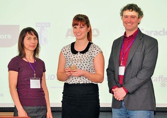
the facilities in Western’s Earth Science Department. On Saturday night there was a banquet dinner at the grad club, which provided a welcome opportunity to mingle and discuss the talks that day, or simply to meet some new people and exchange ideas. The conference ended with the handing out of awards as follows:
The winner of Petroleum Geology session, and the coveted CSPG ammonite, was Colleen Kurcinka of Queen’s University. Her presentation, “Mouth bars in the Lajas Formation, Argentina: Tidally dominated or not?,” is part of her M.Sc. thesis research that she is currently completing under the supervision of Dr. Robert Dalrymple.
The CSPG also presented copies of the publication “Operation Bow-Athabasca” to several honorable mention candidates. Piotr Angiel (Western) – runner-up, best petroleum-related presentation; “Mud transport on a Cretaceous shallow marine ramp in rapidly subsiding foredeep,” part of his PhD research under Dr. Guy Plint. Maurice K. Nguyen (Western) – for his presentation on “Quaternary Glaciation and Stratigraphy of theRidge River Area, Northern Ontario,” under Dr. Stephen Hickock.
Omar Al-Mufti (Ottawa) – for his poster presentation on “Dune or Dune-Like Cross-Stratification in Deep-Marine Sandstones of the Neoproterozoic Windermere Supergroup, Cariboo Mountains, British Columbia, Canada”, which forms the basis for his B.Sc. thesis, supervised by Dr. Bill Arnott. Note that Omar was also the winner of the Best Poster Award, which was sponsored by Imperial Oil.
Several societies including CSPG, CSEG and APGO (the Ontario equivalent of APEGA) set up booths to showcase their organizations and speak with students. Surprise was a common theme, upon finding out that representatives of the CSPG had travelled from Calgary to attend the conference, along with curiosity about employment in the oilpatch after graduation.
The AESRC 2013 organizing committee of Laura Sanchez, Deana Schwarz, Imran Meghji, Jessica Stromberg, and Sarah Sweeney did an excellent job at AESRC 2013, and are to be congratulated on running a successful conference. The CSPG looks forward to continuing to sponsor this event in the future.
28 RESERVOIR ISSUE 6 • JUNE 2013
Colleen Kurcinka (centre), winner of the ‘Best Petroleum-Related Presentation’ award at AESRC 2013, with CSPG Outreach representatives Melanie Klucker and Simon Haynes. (Photo credit: Piotr Angiel).
25TH ANNUAL CSPG/CSEG/CAPL 10KM /5KM
Road Race and Fun Run
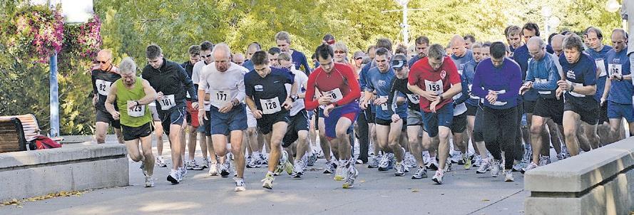
On your mark! Get ready, the CSPG, CSEG, & CAPL will be running our annual Roadrace and Fun Run this September. This is the silver anniversary (25 years and counting) of this event and this year promises to be better than ever!
Again, we are offering both a 10km and a 5km race. We have secured Winning Time to provide chip timing and Events-on-Line will provide easy on-line registration.
The run will take place on Wednesday, September 11, 2013. Start time 6:00pm just north of the Eau Claire YMCA. The route will take you on an out-and-back course along the beautiful Bow River pathway, finishing at the Eau Claire YMCA. Following the race, all racers, volunteers, and guests are invited to gather at the Calgary Curling Club, just north of Princess Island for awards, draw prizes, refreshments, and some friendly camaraderie. So if you are looking for a competitive race or just want to have fun, come join us!
The race is open to all members of the CSPG, CSEG, and CAPL, and the general public, however, space is limited to 200 participants. So register early to avoid disappointment! There will be NO race day registration. For more information or to register, visit the CSPG Events website www.cspg.org\events. For sponsorship opportunities please contact: Dan Cicero 403-531-7711 dcicero@ huntoil.com , Shirley Fleming 403-8063212 Shirley.Fleming@Penngrowth.com or Jocelyn Frankow 403-260-6582 jocelyn_ frankow@sensorgeo.com.
To help you, Gord Hobbins of Gord’s Running Store has developed a 10km race
training guide for novice runners. Try it out and benefit from some expert advice, you may be surprised how easy it can be to gently get yourself in condition for your first race.
G ORD ’ S 12-wEEK T RAINING GUIDE FOR NOVICE RUNNERS
Guidance/Tips: For novice runners who wish a do-it-yourself program at your leisure.
- Run for short durations between 3 and 5 times per week according to schedule, with your long run days being the key to your training program.
- If your running shoes are giving you some problems, get some that fit and match your gait.
- Guide allows for a gradual increase
to a comfortable load; your legs may need some conditioning at first.
-Yes, times are in minutes. The secret is to be regular and not beat yourself up.
-Wear a hat and cool shades. Keep well hydrated. It really helps.
- Gently stretch those calves and quads afterwards.
-Take along a friend and convince them to sign up for CSPG, CSEG, and the RoadRace as well.
Many thanks go out to our sponsors and volunteers who make this event possible each year!
We hope to see you there! Armin Schafer, Race Director.
RESERVOIR ISSUE 6 • JUNE 2013 29
Minute S oF runninG Per Day: Week Mon tues Wed thurs Fri sat sun June 24-June 30 – 10-15 min – 10-15 min – – 15 min July 1-7 – 10-15 min – 10-15 min – – 20 min July 8-14 – 10-20 min 0-10 min 10-20 min – – 25 min July 15-21 – 10-20 min 0-10 min 10-20 min – – 30 min July 22-28 – 10-20 min 0-10 min 10-20 min 0-10 min – 25 min July 29-Aug 4 – 10-20 min 0-10 min 10-20 min 0-10 min – 35 min Aug 5-11 – 15-25 min 0-10 min 15-20 min 0-10 min – 25 min Aug 12-18 – 15-25 min 0-10 min 15-20 min 0-10 min – 40 min Aug 19-25 – 15-25 min 0-10 min 15-25 min 0-10 min – 25 min Aug 26-Sept 1 – 15-25 min 0-10 min 15-25 min 0-10 min – 45 min Sept 2-8 – 20-30 min 0-10 min 15-25 min 0-10 min – 25 min Sept 9-11 – Rest 10 KM RUN
CORPORATE SUPPORTERS
AGAT Laboratories
Apoterra Seismic Processing Ltd.
ARC Resources Ltd.
Arcis Seismic Solutions
Cabra Consulting Ltd.
Canadian Natural Resources Ltd.
CGG Veritas Services Inc.
Compass Directional Services
Continental Laboratories Ltd.
Cossack Land Services Ltd.
Crescent Point Energy Trust
Datalog Technology Inc.
Edge Technologies Inc.
Exova Canada Inc.
Explor
GeoTir Inc.
GLJ Petroleum Consultants Ltd.
IHS
Kulczyk Oil Ventures
LXL Consulting Ltd.
McDaniel & Associates Consulting Ltd.
MOH & Associates Oilfield Consultants
National Oilwell Varco
Nickpoint Environmental Services
Olympic Seismic Ltd.
Paradigm Geophysical Corp.
Pason Systems Corp.
Perpetual Energy Inc.
Pioneer Professional Group
Pro Geo Consultants
ProActive Health
Pulse Seismic
Regent Resources Ltd.
Rigsat Communications
RPS Energy Canada Ltd.
SAExploration
SeisWare
Sensor Geophysical Ltd.
Sigma Explorations Inc.
Sourcex
Total Gas Detection Ltd.
Trident Exploration Corp.
Western Geco
AS OF MAY 10, 2013
CSPG welcomes our 2013 Corporate Supporters!
The benefits of being a corporate member include:
• Recognition in the monthly Reservoir and quarterly Bulletin
• One associate membership
• Reserved tables at the technical luncheons with your company logo
• One free pass to the CSPG Core Conference
…and more! Contact Kasandra Klein at kasandra.klein@cspg.org to be a corporate member today!
H.M. H UNTER AwARD 2012 C ITATION
Lisa A. Griffith
The CSPG is pleased to announce that the winner of the H. M. Hunter Award for 2012 is Lisa Griffith. The Award is given annually to a member of the Society who has served the society over a number of years, usually in a variety of capacities. The Award is named in honour of Harry M. Hunter, one of the original founding members of the society who participated fully in helping the society over 5 decades.
Lisa truly represents the spirit of the H.M. Hunter Award. She has been a member since 1980 and has served the society in numerous capacities.
In the 1980’s, Lisa’s first CSPG volunteer role was on the Graduate Thesis Award Committee where she served for 6 years reading and evaluating candidate MSc and PhD theses.
She has contributed frequently to CSPG Technical Conferences. This has taken the form of many oral and core presentations including Best Oral presentation (1995), and Best integrated Core Presentation (2003). Lisa co-chaired and organized a technical session on Fluvial Systems through Time and Space for the 2000 GeoConvention, and subsequently guest co-edited a CSPG Bulletin highlighting papers from the session (2002). She volunteered as the SEPM Awards chairperson (2005), and as the Core
Conference Technical Committee chairperson (2007).
Lisa has served on the CSPG Executive, both in the capacity of Assistant/ Finance Director (2002-2003), and VP/President/ Past President (2007-2009). Associated executive duties included representing the CSPG at the Canadian Federation of Earth Sciences (2007-2009), the annual Canadian Council of Professional Geoscientists meetings, and the AAPG Leader’s Meeting. Participating on the Compensation and Benefits Committee, and the Education Trust Fund Executive were also inherent in these positions.
Over the years, Lisa has also shared her passion for geology through CSPG Outreach. She travelled on numerous CSPG University Outreach lecture tours between 1996 and 2003, telling undergraduate students in 14 universities across Canada about the wonders of a geological career in the petroleum industry. In addition, she has taught the undergraduate Student Industry Field Trip (SIFT) Clastic Core Workshop in two separate multi-year stints: one in the 1990’s, and a second that started in 2010 and continues to the present.
30 RESERVOIR ISSUE 6 • JUNE 2013
Professionals in Geoscience
www.apega.ca
Mobility
Geoscience is a global pursuit. Its practitioners work on all continents and under all of the Earth’s seas, seeking hidden details of the geological story. Professional Geoscientists are also keen resource seekers. Oil, gas, minerals and engineering materials are all within the Professional Geoscientist’s purview, often without regard to political lines on a map.
Canada has 14 jurisdictions that own the natural resources present beneath their land surface: 10 provinces, three territories and federally owned sea floor. In the case of submarine continental shelf and slope territory claimed by Canada, the full extent of the land is still being established — by Professional Geoscientists, of course.
It is essential to the prosperity of all Canada that knowledgeable people are able to move freely within the country to practice their professions. The Agreement on Internal Trade (AIT) created by our First Ministers guarantees that ability to pursue Professional Geoscience personal and corporate goals anywhere their exploration leads.
APEGA was among the first Alberta professional associations to be ready for AIT, enabling geoscientists who are licensed in all other jurisdictions to join without delay or further examination and APEGA members become licensed to work wherever they choose. This is possible through APEGA’s membership in Geoscientists Canada and Engineers Canada, where all jurisdictions meet to coordinate licensure requirements at the national level. At least 100 geoscientists have taken advantage of AIT to come to work in Alberta. Many more Alberta-licensed geoscientists are contributing their expertise to develop resources in other provinces, territories and around the world. Mobility benefits everyone.
For more information:
Tom Sneddon, P.Geol.
Director Geoscience and Outreach
P: 403-262-7714 or 888-262-3688
E: tsneddon@apega.ca
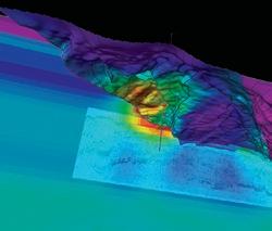
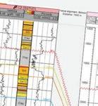
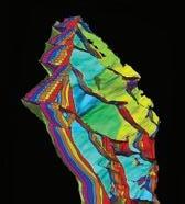
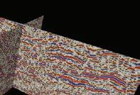
Blueback Reservoir the preferred and chosen GeoScience Solutions Partner Try something new. Find something better. Blueback Rock Physics plug-in for Petrel* Bridging the gap between geology and geophysics The complete suite of rock physics tools for quantitative interpretation across multiple domains within Petrel. Blueback Reservoir blueback-reservoir.com E sales@blueback-reservoir.com | T +1 403 538 4821 blueback-reservoir.com/rockphysics *Mark of Schlumberger 4000 5000 6000 8000 9000 10000 11000 12000 7000 13000 14000 15000 16000 Acoustic impedance (kP a.s/m) 17000 1.4 1.5 1.7 1.6 P/S velocity ratio 1.8 1.9 2.0 2.1 2.2 2.3 2.4 2.5 2.6 2.7 2.8 Por=0.4 Por=0.35 Por=0.3 Por=0.25 Por=0.2 Por=0.15 Por=0.1 Vol shl=0.6 Vol shl=0.4 Vol shl=0.2 Reservoir Properties
Petrel
Wells
