■ Call For Abstracts –2006 CSPG CSEG CWLS Convention
■ Call For Abstracts –2006 CSPG CSEG CWLS Convention
CSPG OFFICE
#160,540 - 5th Avenue SW
Calgary,Alberta,Canada T2P 0M2
Tel:403-264-5610 Fax:403-264-5898
Web:www.cspg.org
Office hours:Monday to Friday,8:30am to 4:00pm
Business Manager:Tim Howard
Email:tim.howard@cspg.org
Office Manager:Deanna Watkins
Email:deanna.watkins@cspg.org
Communications Manager:Jaimè Croft Larsen
Email:jaime.croftlarsen@cspg.org
Conventions Manager:Lori Humphrey-Clements
Email:lori.humphreyclements@cspg.org
Corporate Relations Manager:Kim MacLean
Email:kim.maclean@cspg.org
EDITORS/AUTHORS
Please submit RESERVOIR articles to the CSPG office.Submission deadline is the 23rd day of the month,two months prior to issue date. (e.g.,January 23 for the March issue).
To publish an article,the CSPG requires digital copies of the document.Text should be in Microsoft Word format and illustrations should be in TIFF format at 300 dpi.For additional information on manuscript preparation,refer to the Guidelines for Authors published in the CSPG Bulletin or contact the editor.
COORDINATING EDITOR & OPERATIONS
Jaimè Croft Larsen
CSPG
Tel:403-264-5610 Fax:403-264-5898
Email:jaime.croftlarsen@cspg.org
TECHNICAL EDITOR
Ben McKenzie
Tarheel Exploration
Tel:403-277-4496
Email:bjmck@telusplanet.net
ADVERTISING
Kim MacLean
Corporate Relations,CSPG
Tel:403-264-5610,Ext 205
Email:kim.maclean@cspg.org
Advertising inquiries should be directed to Kim MacLean.The deadline to reserve advertising space is the 23rd day of the month, two months prior to issue date.All advertising artwork should be sent directly to Kim MacLean.
The RESERVOIR is published 11 times per year by the Canadian Society of Petroleum Geologists. This includes a combined issue for the months of July/August.
Advertisements,as well as inserts,mailed with the publication are paid advertisements.No endorsement or sponsorship by the Canadian Society of Petroleum Geologists is implied.
The CSPG Rock Shop is an attractive and affordable way to target the CSPG readership. Spaces are sold at business card sizes (3.5” wide by 2” high).To reserve space or for more information,please contact Kim MacLean at 403-264-5610,ext.205.
The contents of this publication may not be reproduced either in part or in full without the consent of the publisher.
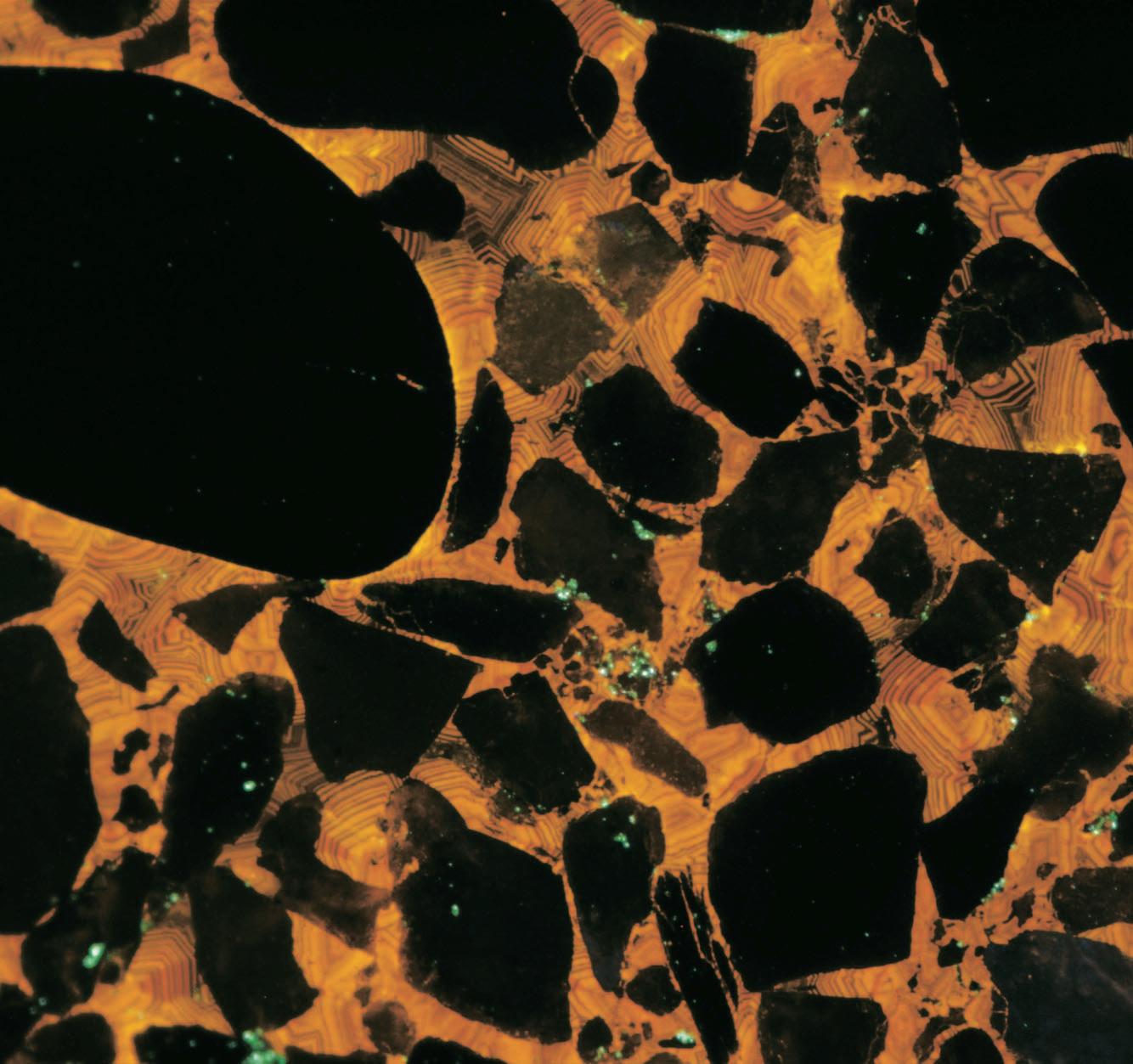
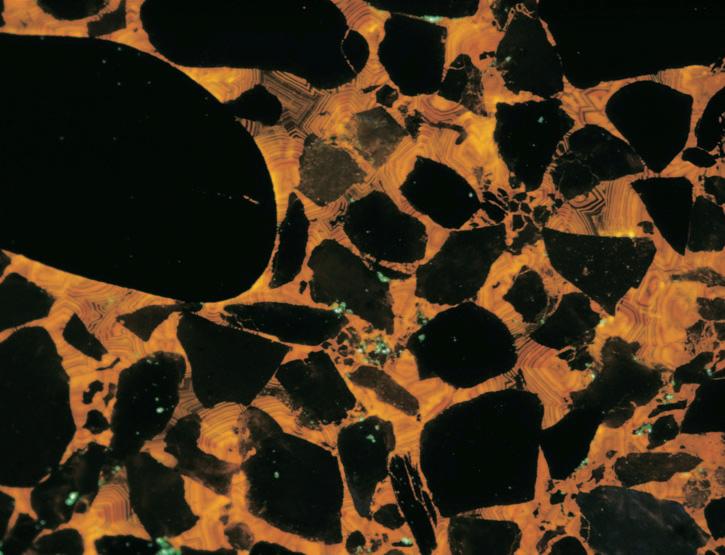
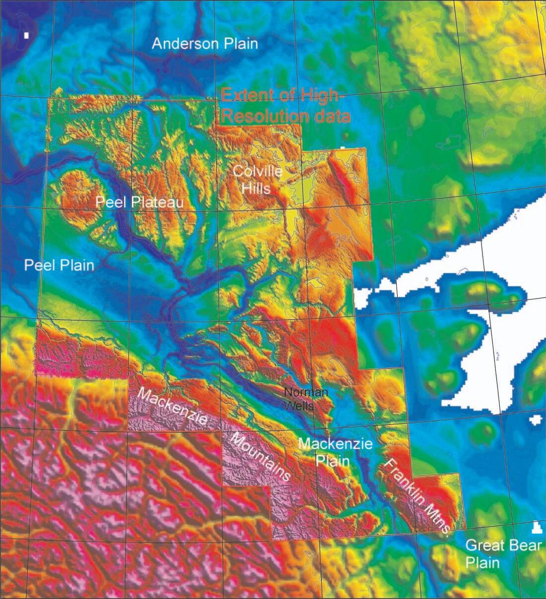
FRONT COVER Northeast Mackenzie Delta,Northwest Territories. Cathodoluminescence image showing sandstones from the Mallik 5L-38 Gas Hydrate Production Well cemented
It has been my privilege to have served on the Executivefor the past three years as your Vice President, President,and now Past President.As I prepare to leave the Executive,it is time to reflect on the past and on the future directions of the Society.
The Society has continued the tradition of having a strong technical program through our annual conferences and regular technical luncheons.The program was augmented by the addition of the Dolomites Conference in 2004 and the Gussow Conferences in 2004 and 2005.Hosting the AAPG in June,with record-breaking attendance was another success,although I think many of us were somewhat overwhelmed with the size and excellent technical content.The success of all these events was due to the dedication of our volunteers and to the generosity of our sponsors.These technical events have been a success financially as well as technically and consequently,the Society is financially strong.
Outreach is another area where we have had a strong focus.The Honorary Address is an annual event which provides an opportunity for the CSPG to raise the awareness of the importance of geology and other sciences to society.University outreach is accomplished through programs such as the Student Industry Field Trip and sponsorship of regional university geological conferences.In spite of these types of programs,we are still having problems attracting students into geology and into the petroleum industry.As professionals,we can all help in alleviating this problem by creating job opportunities for new graduates whenever possible.
One frustration,also recognized by my predecessors,has been the difficulty in attracting volunteers to run for the Executive.Despite having a membership of 3,000,we have not had elections for the past few years because we cannot get enough members interested in being candidates.I strongly encourage you to consider running in the future.I know there are a lot demands on everyone’s time,but with our strong committee structure,and with the excellent support of our office staff,the requirements of serving on the Executive are not that onerous.
A MESSAGE FROM THE PAST PRESIDENT
Looking to the future,your Executive has embarked on a new strategic planning process. As a Society,we have a major challenge ahead since the industry is currently not hiring enough new graduates to replace those of us who will be retiring over the next decade. Other organizations are already facing decreases in their memberships;we have to develop a strategy of keeping ours strong. Therefore,the strategic planning process was initiated in the Spring and based upon an analysis of demographic information,input from members (2004 membership survey),and an additional survey of select members and stakeholders.Collation of that input and subsequent analysis during a workshop has enabled the Executive to arrive at some objectives which will be the basis for future planning and implementation.The work to date indicates that our technical programs continue to be top priority.In the medium to longer term,there is a desire to expand our outreach activities for the purposes of encouraging young people to pursue careers in the geosciences and to expand our membership and become truly a Canadian,rather than a perceived Albertan,organization.These objectives will require a continuing strong volunteer base as well as significant financial resources if we are to be successful.However, like any organization,the best success comes from setting and achieving lofty but realistic goals.A more detailed summary of the results of the strategic planning process will be included in a future edition of the Reservoir. Please review the contents and express any thoughts you may have to any member of the Executive.It is your Society so please do not hesitate to make suggestions regarding its mandate and future direction.
I would like to thank our office staff – Tim Howard,Jaime Croft Larsen,Deanna Watkins, Kim MacLean,Lori Humphrey-Clements,and Sarah Venance - for the ongoing support they provide to the membership as well as to the Executive.They definitely keep us organized and provide the knowledge and expertise to effectively run our programs and services and they were an invaluable resource to me personally during my tenure.Thanks also to my employer,Husky Energy,for allowing me to serve the Society during the past three years.
In conclusion,the CSPG is currently very strong and is under the direction of another excellent Executive.Thank you again for the opportunity of being able to contribute.
Craig F.Lamb,Past President
depths
CONTOURING
Faulted contours
Isopachs
Volumetrics
Grid operations
New flexing options
CROSS SECTIONS
New Unassigned Tops
Digital and/or Raster
Geocolumn shading
Stratigraphic/Structural
Shade between crossover
Dipmeter data
MAPPING OPTIONS
Expanded GIS Functions
Bubble maps
Production charts
Log curves
Posted data
Highlighted Symbols
3D VISUALIZATION
Deviated wellbores
Digital logs
Grid surfaces
Tops, Shows and Perfs
Land grid overlay
Map images
PETRA® delivers the industry’s only easy-to-use and affordable integrated solution for today’s workflows. It provides multi-user access to large projects through geological, petrophysical and engineering analysis tools. The PetraSeis™ option extends PETRA® into 2D/3D seismic interpretation with practical tools such as RasterSeis™ Download a trial version at www.geoplus.com, or call us at 888-738-7265 (Houston: 713-862-9449 / Calgary: 403-264-9523) for more product information.
DECLINE CURVES
Compute EUR, RR, etc.
Hyperbolic or exp.
Rate/Time or Cum P/Z
User defined Econ. Limit
User defined Extrap. Time
THE CSPG GRATEFULLY ACKNOWLEDGES ITS CORPORATE MEMBERS:
THE CSPG GRATEFULLY ACKNOWLEDGES ITS CORPORATE MEMBERS:
ABU DHABI OIL CO., LTD. (JAPAN)
BAKER ATLAS
BG CANADA EXPLORATION & PRODUCTION, INC.
BP CANADA ENERGY COMPANY
BURLINGTON RESOURCES CANADA LTD.
CALPINE CANADA
CANADIAN FOREST OIL LTD.
CONOCOPHILLIPS CANADA
CORE LABORATORIES CANADA LTD.
DEVON CANADA CORPORATION
DOMINION EXPLORATION CANADA LTD.
DUVERNAY OIL CORP.
ECL CANADA
geoLOGICsystems ltd.
GRIZZLY RESOURCES LTD.
HUNT OIL COMPANY OF CANADA, INC.
HUSKY ENERGY INC.
IHS ENERGY
IMPERIAL OIL RESOURCES LIMITED
LARIO OIL & GAS COMPANY
MJ SYSTEMS
MURPHY OIL COMPANY LTD.
NCE RESOURCES GROUP INC.
NEXEN INC.
NORTHROCK RESOURCES LTD.
PENN WEST PETROLEUM LTD.
PETRO-CANADA OIL AND GAS
PETROCRAFT PRODUCTS LTD.
PRECISION ENERGYSERVICES
PRIMEWEST ENERGY INC.
SAMSON CANADA
SHELL CANADA LIMITED
SPROULE ASSOCIATES LIMITED
STARPOINT ENERGY LTD.
SUNCOR ENERGY INC.
TALISMAN ENERGY INC.
TOTAL E&P CANADA LIMITED
CORPORATE MEMBERS AS OF SEPTEMBER 24, 2005
A BRILLIANT MOVE
IN INTERNATIONAL SEISMIC ACQUISITION
IN INTERNATIONAL SEISMIC ACQUISITION
Playing a game that is foreign to you can be tough at first. There are many different rules and tactics involved.
Twenty-seven years and some 38 countries later, Boyd PetroSearch has developed extensive seismic acquisition experience around the world.
Trust us to manage your international seismic operation, and ensure the highest degree of professionalism and quality. The next move is up to you…
• Program Design
• Logistics
• Risk Analysis & Mitigation
• Contract Negotiation
Please call:
John Boyd 403.543.5373
Larry Herd 403.543.5362
• Project Management & Hiring
• Quality and Cost Control
• International Safety Compliance
Kevin Bowman 403.543.5357 or visit www.boydpetro.com Boyd Exploration Consultants Ltd.
TECHNICAL LUNCHEONS
NOVEMBER LUNCHEON
Origin,architecture, sedimentary characteristics and reservoir properties of bioclastic accumulations (i.e.,‘coquina’),Lower-Middle Triassic of the WCSB
Proudly sponsored by: SPEAKERS
Thomas F.Moslow Midnight Oil Exploration Ltd./ Daylight Energy Trust
John-Paul Zonneveld Geological Survey of Canada-Calgary 11:30 am
Thursday,November 3,2005
TELUS CONVENTION CENTRE CALGARY, ALBERTA
Please note:
The cut-off for purchasing tickets is 1:00 pm,Monday,October 31,2005. Ticket price is $28.00 + G.S.T.
Bioclastic accumulations commonly referred to as ‘coquina’,comprise important reservoir lithologies in Lower-Middle Triassic strata in the Western Canada Sedimentary Basin (i.e.,Montney,Doig,and Halfway formations).These ‘coquinas’ commonly occur in successions that are otherwise dominated by fine-grained siliciclastic sediment.The shell debris that comprises a ‘coquina’ typically has mineralogical,textural,and compositional properties distinct from that of the host strata,which must be assessed to accurately interpret their depositional history and ultimate reservoir quality.The genesis and significance of ‘coquina’ are commonly misunderstood.Accurate description and interpretation of this lithology can facilitate exploration for coquina-hosted hydrocarbons and maximize production from known ‘coquina’ pools.
In modern-day settings,examples of bioclastic accumulations are numerous and varied.As life assemblages (i.e., autochonous accumulations) they occur within a broad spectrum of ecological parameters from brackish to fully marine
conditions.Such assemblages are commonly monospecific bioherms or biostromes in ecologically stressed environments such as brackish-water tidal estuaries,muddy tidal flats,and euryhaline bays or lagoons.While these assemblages are an important source of bioclastic material,the preservation potential is typically low based on limited representation in the sedimentary record. This is likely due to intense mechanical abrasion through hydrodynamic transport in siliciclastic settings and/or rapid postburial dissolution of shell valves and tests. Modern-day environments where reworked and transported bioclastic accumulations (i.e.,allochthonous assemblages) occur are also diverse.Some,such as bioclastic cheniers (beachridges) have minimal preservation potential.In contrast,large volumes of allochthonous bioclastic material with high preservation potential occur in the upper shoreface,tidal inlets, ebb- and flood-tidal deltas,estuarine tidal channels,and tidal point bars.Stratigraphic studies in modern tide- and wavedominated barrier island shorelines have shown that approximately 50% of the preserved facies are of bioclastic origin and deposited in tidal inlet and/or ebb- and flood-tidal delta environments.
Accurate assessment of ancient bioclastic accumulations requires five categories of information:1) Bed geometry and stratal relationships,2) Taphonomic grade (state of preservation) and taxonomic composition of shell debris in the coquina,3) Biofabric (three-dimensional arrangement of skeletal debris),4) Clast composition and fabric,and 5) Post-depositional diagenetic alteration.
Ancient examples of Triassic bioclastic (‘coquina’) facies include the Coquinal Dolomite Member (CDM),a primary reservoir unit in the Montney Formation of west-central Alberta.Bivalve and lingulide concentrations characterize the CDM. Although these accumulations occur at several levels in the Montney Formation, some of the thickest are associated with a mid-Montney (Dienerian-Smithian) sequence boundary.During early transgression lingulides were reworked from marginal marine successions,mixed with shorefacederived bivalves and redeposited in a series of ridges and bars proximal to estuary mouths.Middle Triassic mixed siliciclasticbioclastic accumulations are more common and considerably more diverse.Brachiopod
and bivalve dominated bioclastic tidal inlet channel fill,deposited during lowstand and early transgression within a barred barrier island shoreface succession,comprise a significant reservoir lithology within the Doig/Halfway interval at Tommy Lakes Field in northeastern British Columbia and several other pools along the middle Triassic subcrop edge of west-central Alberta.
In outcrop exposures of ‘coquina’ facies, low-relief biostromes dominated by articulated terebratulid brachiopods and disarticulated,unabraded crinoid and echinoid skeletal elements are common within the Halfway-equivalent shoreface sandstone units in the Liard Formation. These autochthonous accumulations may represent potential reservoir units if identified in the subsurface.Stormgenerated skeletal concentrations provided islands of stable substrate,which were subsequently colonized by terebratulid brachiopods,cidaroid echinoids,and articulate crinoids.Allochthonous bioclastic upper shoreface successions also occur in outcrop of the Liard Formation.Rare outcrop analogues of the Halfway bioclastic tidal inlet channel successions also occur in the Liard Formation.
The complex sedimentologic characteristics and hybrid lithologies of ‘coquina’ hydrocarbon reservoirs makes petrophysical analysis and reservoir characterization extremely challenging.In addition,diagenesis commonly alters the original depositional fabric making sedimentologic reconstructions challenging and environmental interpretations difficult. Dolomitization and replacement of framework grains and matrix is common in ‘coquina’ reservoirs with subsequent enhancement of reservoir quality through generation of microfractures and secondary porosity.High boundwater volumes,mixed lithologies,and varied mineralogical properties present significant challenges with a high margin of error in determination of reservoir properties from well logs.As a result,the utilization of core-to-log correlations to provide a rockbased ground truth to reservoir quality assessment is essential.Unique and complex reservoir properties make this play type one with a relatively low level of predictability and high degree of heterogeneity.As a result, numerous opportunities still exist for exploration and exploitation of bioclastic ‘coquina’ hydrocarbon reservoirs.
NOVEMBER LUNCHEON
Finding large gas reserves in the Foothills of the WCSB
SPEAKER
Andrew Newson
Moose Oils Ltd.
11:30 am
Thursday,November 17,2005
TELUS, CONVENTION CENTRE CALGARY, ALBERTA
Please note:
The cutoff date for ticket sales is 1:00 pm,Monday,November 14th. Ticket Price is $28.00 + GST.
The Foothills of the Western Canada Sedimentary Basin (WCSB) has a long history of natural gas production for the Canadian and American markets.As a supplier to the North American gas market, the Foothills will continue to play an important role over the next 10 years due to the steady upward pressure on natural gas prices resulting from increased demand and decreased supply.This firming in price, coupled with the existence of an established infrastructure in the Foothills,will allow the economical development of many of the remaining natural gas prospects.
Annual Production in mmcf of marketable gas
One of the reasons for the unique nature of the Foothills belt is the type of geological structures that are found in the surface and subsurface.The Foothills are part of the larger fold-and-thrust belt of the Rocky Mountains,a geological structural domain where the sedimentary rock of the WCSB has been deformed by horizontal compression.The rocks have been effectively shortened by one of two mechanisms.In some cases,the structural complexes have reservoir rocks faulted and stacked on top of each other to form structures in which the reservoir rock may be fault repeated two or three times.In other cases,the rocks have been folded by the horizontal compression into tight folds where the reservoir rock may be broken or fractured.
The Foothills plays have been divided up based on structural style,stratigraphic framework and history of exploration.They are the First, Second,Third Generation,Stratigraphic,and Triangle Zone play types.(Fig.1).
Production from the various play types has changed over time.Early production was dominated by the Reef/Stratigraphic,First, and Second generation plays.Since the mid1980s,the Third generation and Triangle zone plays have contributed an increasing amount to the annual production.(Fig.2) Recent discoveries,whose production
rates are still unpublished,would appear capable of significantly changing this production profile.
Based on the latest work by the Canadian Gas Potential Committee,the Foothills have 27 TCF yet to be discovered in existing plays. The three largest fields left to be discovered in the WCSB will be in the Foothills and each will be greater than 1 TCF in size.
BIOGRAPHY
Andrew Newson has 30 years of experience in the geological and geophysical evaluations of overthrust belts.He has been the recipient of numerous awards.Among them w7as the CSPG’s Link Award in 2000 for his talk “Foothills,The Future for Exploration.”His company Moose Oils Ltd has also received an award from NSERC and the Conference board of Canada for its contribution to the Fold-Fault Research Project.He is a regular speaker at conferences both domestically and internationally and has undertaken numerous roles as technical editor and chairperson for the CSPG structural geology group.
Figure 2
DECEMBER LUNCHEON
Stratigraphy,sedimentology, and paleogeography of the Lower Jurassic Gordondale Member, west-central Alberta
SPEAKER
Michèle Asgar-Deen University of Calgary
10:30 am Christmas Social
Exhibition Hall Foyer 11:30 am Luncheon
Exhibition Hall E Tuesday,December 6,2005
TELUS CONVENTION CENTRE CALGARY, ALBERTA
Please note:
The cut-off date for ticket sales is 1:00 pm,Thursday,December 1st. Ticket price is $28.00 + GST.
Detailed stratigraphy of fine-grained strata is crucial to our understanding of basin evolution,stratigraphic traps,and source
rock potential.Appreciation of these parameters becomes even more important as we begin to exploit unconventional resources such as shale gas.Although the stratigraphy of coarse-grained strata within the Western Canada Sedimentary Basin is well known,much work remains before the stratigraphy of fine-grained packages are well understood.
Regional Lower Jurassic stratigraphic correlations based on detailed petrography, new biostratigraphic data,geophysical log correlations,and detailed core and outcrop descriptions have yielded surprising results. Discrepancies in the previous stratigraphic framework were resolved by introducing a new member,the Gordondale Member of the Fernie Formation,to replace the informal “Nordegg Member” terminology.
The Gordondale Member is Hettangian to late Toarcian in age.It consists of highly organic,radioactive,phosphatic,and finegrained strata that are lithologically distinct from adjacent Nordegg Member cherty limestones.The Gordondale Member
STRATEGY 2005
includes Hettangian basal Fernie strata of northeastern British Columbia,and is correlative with the Red Deer Member, cherty limestone of the Nordegg Member, and the lower Poker Chip Shale.
This new stratigraphic framework has also helped reveal a surprisingly dynamic Lower Jurassic paleogeography.During the Hettangian to Pliensbachian,the Gordondale Member transgressed,from west to east,over the North American craton.A west-facing,north-south oriented carbonate ramp was prominent during the Pliensbachian.The northern portion of the ramp was drowned during the Toarcian and overlain by fine-grained strata,and the southern portion of the ramp prograded northwards.A raised sill area developed in northeastern British Columbia during the Toarcian.Later during the Toarcian,the sill migrated eastwards and became broader. A basin-wide episode of erosion occurred during the late Toarcian as evidenced by a regionally extensive phosphatic conglomerate.The changes in Toarcian paleogeography,as well as a shift to coarser sedimentation,are discordant with proposed global sea-level changes.
The single largest influence on the deposition of the Gordondale Member was its silled-basin morphology.The sill restricted circulation with more marine conditions,particularly during periods of low relative sea-level,and may have contributed to a stratified water column resulting in poorly oxygenated bottom waters.These poorly oxygenated conditions are associated with an absence of bioturbation and benthic fauna. These conditions also facilitated the preservation of organic matter,resulting in total organic carbon contents ranging up to 28 weight percent.
BIOGRAPHY
Michèle Asgar-Deen is a Ph.D.student under the supervision of Dr.S.Larter at the University of Calgary,where she also received her B.Sc. and M.Sc.in 1997 and 2003 respectively.This presentation is based on her master’s work, supervised by Dr.C.Riediger,which won the CSPG 2004 M.Sc.Thesis Award.She has presented at several conferences including the GAC-MAC and AAPG annual meetings and received the 2003 Andrew Baillie Award for best student paper at the CSPG convention. Michèle also has three years work experience with Crestar Energy Ltd.
DIVISION TALKS
GEOFLUIDS DIVISION
Applications of 1-D basin modeling in Trutch map area and adjacent plains, Northeastern British Columbia and Northwestern Alberta
SPEAKER
Ayse Ibrahimbas Ismik and Cindy Riediger Department of Geology and Geophysics University of Calgary
12:00 Noon
Thursday,November 17,2005
ConocoPhillips Auditorium
3rd Floor (above +15 Level)
401 – 9th Avenue SW Calgary, Alberta
Quantitative 1-D basin modeling is applied to the Paleozoic to Mesozoic stratigraphic section in 11 wells in the area bounded by 57°-58°N and 118°-124°W.The study reconstructs the thermal and burial history of this area in order to investigate the timing of hydrocarbon generation from known source rocks,migration fairways, and timing of migration into traps. Known source rocks in the study area include Exshaw,Montney,Phosphate Zone,Pardonet,Gordondale,and Wilrich formations.
The amount of the Tertiary erosion increases dramatically from 900 to 1,900 metres from east to west,with concomitant increase in thermal maturity
STRUCTURAL DIVISION
4-D multidisciplinary integration delivers a reliable structural model for the Eastern Venezuela Thrust Belt –critical review of the methodology and of the tools
SPEAKER
Jean-Yves Chatellier Consultant
12:00 Noon
Thursday,November 10,2005
Petro-Canada
West Tower, room 17B/C (17th floor) 150 - 6th Avenue SW Calgary, Alberta
The Furrial Trend in the Eastern Venezuela Thrust Belt is complex and comprises a series of giant fields including the Furrial,Carito,and Santa Barbara Fields.More than 500 deep wells and numerous 3-D seimic surveys have been extensively studied.A successful in-depth multidisciplinary integration has given new and vital insights of the structure,especially in the Santa Barbara Field,the most complex of these giant fields.
Combining and interpreting data from different sources often seem impossible as conflicting information appears to be the norm.The real problem is that we are dealing with different parameters (rock,fluid,
pressures) that respond differently to tectonic deformation and to depletion through time.Pressure and geochemistry data are responding variably and in their own way to depletion and a 4-D analysis was thus needed to integrate all of the data available from seismic,geology,geochemistry,and reservoir engineering.
Many of the thrusts were best identified by geochemistry (oil gravity depth trends, isotopes) or by pressure depth trends. Many new methods were invented;some will be described and criticized,e.g.,a poorman’s dipmeter based on abnormal water saturation trends or the identification of detachment planes using RFT data (Repeat Formation Tests).In many cases successful integration started from anomalous production behavior leading to alternative,reliable,and tested/confirmed structural interpretations. Four phases of deformation have been identified and timed with respect to hydrocarbon migration phases.
The success of the integrated approach was measured by a dramatic increase in reliability of the static model (prognosis down to 60m from 400m before multidisciplinary integration) and by the predicted discovery of a giant extension of the field in an unexpected location of the thrust belt and another one in a similar position in the Tacata Giant Field (in the triangle zone).
towards the west.The Exshaw Formation entered the oil window 243 Ma in the west with expulsion starting as early as 113 Ma, and in the east,hydrocarbon generation started 81 Ma but didn’t reach the threshold of expulsion.The Mesozoic source rocks are in the oil window west of 120°W,with hydrocarbon generation starting about 88-62 Ma.
PROUD SPONSORS
BIOGRAPHY
Jean-Yves Chatellier earned a “licence”and a “maitrise”in geology from Lille (France) and obtained a DEA and Ph.D.in tectonics from the University of Pierre et Marie Curie in Paris;in between he got an M.Sc.in sedimentology from U of C while doing his military service in Calgary and later an MBA from Henley Management College (UK).
From a start with Aquitaine he joined Petroconsultants in Ireland before working around the world for Shell International for nine years as an exploration and production geologist and as seismic interpreter.His main areas of study include the North Sea,New Zealand,Thailand,Brunei,and West Africa.He left Brunei Shell to accept a job as senior research geology advisor for Petroleos de Venezuela.He worked on numerous projects in western and eastern Venezuela for seven years until the national strike that brought the Venezuelan industry to the breaking point.
He is a presently a Calgary-based geological consultant working mostly on the Western Canada Basin and focusing on plays that integrate sedimentation and tectonics.
INFORMATION
Talks are free;please bring your lunch.Goodies and drinks are provided by HEF Petrophysical Consulting,and the room is provided by Petro-Canada.If you would like to be on the Structural Division e-mail list,or if you’d like to give a talk,please contact Elizabeth Atkinson at (403) 296-3694 or eatkinso@petro-canada.ca.
GEOMODELING DIVISION
Uncertainty quantification and ranking for SAGD well pair placement in the McMurray Oilsands,Canada
SPEAKER
David Garner
ConocoPhillips Canada Ltd.
CO-AUTHORS
Emmanuel Mus and Jean-François Richy, Total E&P Canada Ltd.,seconded to ConocoPhillips Canada Ltd.
T.J.Wheeler
ConocoPhillips Canada Ltd.
12:00 Noon
Wednesday,November 30,2005
ConocoPhillips Auditorium
3rd Floor- above Plus 15+ level
401 9th Ave SW
Calgary,Alberta
The McMurray Formation is a highly heterogeneousCretaceous clastic reservoir with thick,bitumen-saturated sands.For the Surmont lease,SAGD is being implemented to extract the bitumen.The project initially targets twenty horizontal well pairs.The main goals in this study were to aid and improve the complex decision-making for
NEW MEMBER LIST
vertical placement of horizontal wells,for optimizing expected performance,and for ranking the horizontal well pairs.A detailed workflow was developed.It consisted of integrating multi-scale data,building geological models and post-processing realizations to account for uncertainties in steam chamber development.
Due to the nature of the reservoir,the SAGD process and this particular evaluation of post-processing models,each well pair can be studied as an individual reservoir within the surrounding drainage volume.To decide on vertical well placement,postprocessing of the detailed geostatistical simulations provided uncertainty measures on the reservoir parameters as a function of elevation.Among the parameters computed and compared were effective well length, net-to-gross,facies proportions,producible volumes,and a vertical discount factor on stranded volumes.This approach was a key element of the final elevation decision for the development wells.A comparison was made to the purely deterministic geological approach.
The proposed wells were ranked by performance.A probabilistic model was developed to capture the reservoir parameter uncertainties and simulate performance of each well pair at a specific
elevation.The ranking model used the well placements,extracted reservoir parameter distributions,and SAGD operating conditions,employing Butler theory in a Monte Carlo framework.Vertical well placement was further optimized as a result of this performance-based criteria.These probabilistic outcomes and rankings were used to decide which subsets of planned well slots to drill first.
BIOGRAPHY
David Garner obtained an M.S.Geophysics from Cornell University in 1983.He has been involved with the Surmont Oilsands development for more than five years.David has worked on domestic and international reservoir studies in North Africa,West Africa,the Middle East,North America,and South America. He worked for Chevron from 1982 to 1995.In 1996,he established himself as a quantitative reservoir characterization specialist through TerraMod Consulting Inc.prior to joining ConocoPhillips Canada Ltd.in 2002.
INFORMATION
There is no charge.Non-members of the CSPG are also welcome.Please bring your lunch.For details or to present a talk in the future,please contact David Garner at 403-233-3126, e-mail: David.Garner@ConocoPhillips.com or Peter Dankers at 403-770-0350,e-mail: Peter.Dankers@divestco.com
PALAEONTOLOGY DIVISION
Fossil fuel is ...just fossils.
SPEAKER
Ossama I.I.Yousif
BDR Consulting Ltd.
7:30 PM
Friday,November 18,2005
Mount Royal College Room B108
4825 Richard Road SW Calgary, Alberta
Petroleum is referred to as ‘fossil fuel’, (Robley K Mathews:1984).Is it a fossil? Generally,a living organism becomes a fossil when it lacks the energy to continue on living,and only a relic is left to indicate it ever existed.Paleontology deals with fossils; their life span,trophic mode,habitat,bloom, and extinction.It is,therefore,questionable wisdom to see the most intelligent of species,increasingly depending on fossils for their energy to survive.In this talk, paleontological investigative tools are dynamically mobilized to outline the implications of such practice.We will see if fossil-finding techniques are applicable to finding more fossil fuels.If we already have found all there is to find,and if nature,in storing all that energy,all these hundreds of millions of years,meant for Homo sapiens to spend it all in less than three hundred years.An attempt will be made to locate niche stresses,and if the practice is speeding the living away from or nearer to extinction. Can the process can be reversed or at least slowed down?
James Hutton laid out the first foundation of dynamic stratigraphy in the phrase:‘present is the key to the past’.In this talk,an attempt is made to see if:‘past is the key to the future.’ Just look at all that lived before us…
Legend has it,that a city-state,for weeks, went on arguing what comes first:the chicken or the egg,while the enemy took the opportunity to conquer the city.If they had only one paleontologist,the argument would have been settled in a minute,and the city saved.Will it take a paleontologist, today,to convince policy makers and economists,which comes first:survival or profit?
BIOGRAPHY
Ossama I.I.Yousif is a graduate (M.Sc.Mining Engineer-Geologist) of Gubkin Petrochemical and Gas Industries Institute,Moscow State University,in 1963.He worked in the Middle East and Sudan,before moving to Canada in 1972.He is presently the CEO of BDR Consulting Ltd.,where he is involved in alternate energy,environment,and rewriting of Geology of Petroleum.
INFORMATION
This event is jointly presented by the Alberta Palaeontological Society,Mount Royal College and the CSPG Palaeontology Division.For information or to present a talk in the future please contact CSPG Paleo Division Chair Philip Benham at 403-691-3343 or programs@albertapaleo.org. Visit the APS website for confirmation of event times and upcoming speakers: http://www.albertapaleo.org/
EMERGING PETROLEUM RESOURCES DIVISION
Emerging Petroleum Resources Division
Speaker and date to be announced. Please watch www.cspg.org for more information.
INFORMATION
All EPRD noon-hour talks are free and do not require registration.Non-CSPG members are also welcome to attend.Please bring your lunch.If you would like to join our email distribution list,
CALENDAR OF EVENTS
2005
DATE: November 8-10,2005
EVENT: 7th Annual Unconventional Gas Conference
LOCATION: Telus Convention Centre,Calgary,Alberta
INFORMATION: 7th Annual Unconventional Gas Conference. The largest conference on unconventional gas in North America will be hosted by the Canadian Society for Unconventional Gas. E-mail:kmarkle@csug.ca,403-218-7720, Website:http://events.csug.ca/ugc
DATE: November 9,2005
EVENT: 2nd Annual STAN Conference
LOCATION: Doubletree International Plaza Hotel Toronto,Ontario
INFORMATION: The theme of the conference is “Advancing a Science & Technology Culture in Canada.” Guest speakers include Mr.Preston Manning and Dr.Lee Smolin (Perimeter Institute). For more information about the conference, registration and accommodation,please visit the Science and Technology Awareness Network (STAN) website at:http://www.scienceand technologynetwork.ca/ index.htm or contact Leanne Suffel at 1-866-352-3060 or Isuffel@letstalkscience.ca
suggest a topic,or volunteer to present a talk, please send a message to Michelle.Hawke @bp.com or fredhyland@mcleay.ab.ca
DATE: November 13-17,2005
EVENT: SETAC North America 26th Annual Meeting
LOCATION: Baltimore,Maryland
INFORMATION: The Society of Environmental Toxicology and Chemistry (SETAC) will hold the SETAC North America 26th Annual Meeting at the Baltimore Convention Center in Baltimore,Maryland, November 13-17,2005.This year’s theme is “Environmental Science in a Global Society: SETAC’s Role in the Next 25 Years.” More information can be found on the society’s website www.setac.org
2006
DATE: April 9-12,2006
EVENT: AAPG Annual Convention
LOCATION: Houston,Texas
INFORMATION: For more information please visit www.aapg.org
DATE: May 15-17,2006
EVENT: GAC/MAC Annual Meeting
LOCATION: Montreal,Quebec
INFORMATION: For more information please visit http://www.er.uqam.ca/ nobel/gacmac/index.htm
DATE: May 15-18,2006
EVENT: 2006 CSPG CSEG CWLS Joint Convention
LOCATION: Calgary,Alberta
INFORMATION: For more information please visit www.GEOconvention.org
JACK PORTERVIGNETTES OF CANADIAN PETROLEUM GEOLOGY
J.B. TYRRELL’S INTREPID JOURNEY ACROSS THE BARREN GROUNDS
BY CANOE TO HUDSON BAY
As an introduction to the narrative of Joseph Burr Tyrrell’s crossing by canoe over Canada’s Barren Grounds to Hudson Bay in 1893, reference is made to previous incursions undertaken during the 18th and 19th centuries.
Two of the earliest Europeans to have travelled on Canada’s Barren Grounds were Henry Kelsey and Samuel Hearne,both being in the service of the Hudson’s Bay Company. Kelsey,at age 14,was indentured as a servant with the Company in 1684.In the summer of 1689 he,along with a young native companion, Thomas Savage,departed from York Factory in a Company ship and were landed on the Bay’s northwest shore somewhere north of Seal River.Governor Geyer of York Factory had instructed them to search for Northern Indians (Chipewyan) and,if contacted,to entice them to bring their furs to the Factory to barter for European articles.After wandering a distance of some 200 miles over a desolate,mosquito-infested landscape,they were unable to locate any natives.The pair returned on foot to York Factory,after being absent for 53 days,during which period they endured extreme privation.
Hearne’s career commenced as a midshipman with the Royal Navy when he was a young lad of 12 years.1n 1765,at the age of 20,he entered the service of the Hudson’s Bay Company and was posted to Fort Prince of Wales,located at the mouth of the Churchill River,where he initially served as a mate on one of the Company’s vessels.The fort’s governor,Moses Norton,had convinced Governor Sir William Baker and Committee in London to sanction an overland journey to locate the copper “mines” at the mouth of a large river (Coppermine) flowing into the Arctic Ocean.Having received permission from London,Moses Norton selected Samuel Hearne to accompany native parties trading at Fort Prince of Wales to lead him to the copper occurrences at the river’s mouth.He was also to ascertain if the river’s meeting with the Arctic Ocean would provide a navigable entrance to a Northwest Passage which would access the Pacific Ocean.To this end,Hearne was involved in three attempts to accomplish his mission,the first two, commencing on November 6th,1769 and February 23rd,1770,were failures.During the second attempt,Hearne and his party of
Northern Indians (Chipewyan) entered the Barren Grounds north of Seal River on June 20th,1770.The lack of food in the inhospitable region resulted in their having to consume pieces of their skin garments as their only recourse for survival.Fortunately, their plight was thwarted following the slaughter of three muskox,whose flesh they devoured raw as no firewood could be found. Hearne’s third journey,under the astute leadership of Matonabbee,commenced on December 7th,1770.They crossed the Barren Grounds to reach the mouth of the Coppermine River on July 17th,1771,only to find it,as noted by Hearne:“so full of shoals and falls that it was not navigable even for a boat,and that it emptied itself into the sea over a ridge or bar.” and further:“The ice was not then broke up,but was melted away for about three quarters of a mile from the main shore,” (Hearne,Samuel:A Journey from Prince of Wales’s Fort in Hudson’s Bay to the Northern Ocean 1769 - 1770 - 1771 - 1772; ed.by Richard Glover,with introd.,1958,pub. The Macmillan Company of Canada Limited). The following day,Hearne’s party commenced their return to Fort Prince of Wales,leaving in a south-by-southeast direction to visit one of the copper “mines,” located at a distance of 30 miles from the mouth of the Coppermine River.To quote Hearne:“This mine,if it deserves that appellation,is no more than an entire jumble of rocks and gravel,which has been rent many ways by an earthquake.” and further:“I and almost all my companions expended near four hours in search of some of this metal,with such poor success,that among us all,only one piece of any size could be found.This,however,was remarkably good, and weighed above four pounds.* Glover’s (ed.) footnote reads:*This piece of Copper is now in the possession of the Hudson’s Bay Company.(It was given to the British Museum in 1818.J.B Tyrrell,Hearne and Turnor Journals,p.31).Hearne was further disappointed when the local Copper Indians refused his invitation for them to travel to Fort Prince of Wales to traffic their furs.They considered the distance too great and preferred to continue to deal with the Chipewyan natives who served them as middlemen,(1939,Morton,Arthur S.:A History of the Canadian West to 1870-71, pub.Thomas Nelson & Sons Ltd.,Toronto,p. 298).Hearne and his party arrive back at Fort Prince of Wales on June 30th,1772,their outgoing journey to the mouth of the Coppermine River from the fort took 223 days while their incoming journey amounted
to 348 days.The prolonged homecoming involved an initial circuitous journey to the south,below the tree line,to Great Slave Lake and then east,to join up with their outgoing route.This deliberate diversion afforded Hearne and his party greater opportunities for an assured food supply as well as for the aquisition of furs.
Joseph Burr Tyrrell,geologist,explorer,and historian,joined the staff of the Geological Survey of Canada as a conditional appointee in 1881.The previous year he had received a Bachelor of Arts degree from the University of Toronto.Following graduation,he articled with a legal firm in Toronto but very shortly realized that the legal profession was not his calling.His inate interest in natural science was directed toward geology under the informal tutelage of Edward Chapman,a geology professor at the University of Toronto.It was through Chapman that the young Tyrrell was made familiar with the annual publications and accompanying geological maps produced by the Geological Survey of Canada.When Joseph
(Continued on page 20...)
Now available for impor t into ACCUMAP and other mapping programs:
1) New 2004 Version: Glauconitic Channel Trends - Southern and central Alberta, West-central Saskatchewan
2) New: Lloydminster Reservoir Trends - Eastern Alberta
3) Mississippian Subcrops and Devonian Reef Edges - Alberta, NE BC, NWT and Saskatchewan
4) Colony/Sparky Reservoir Trends - East - central Alberta
5) Bluesky-Dunlevy Reservoir Trends - NE BC
6) Halfway-Doig Shoreline Trends - Peace River Arch, NE BC
7) Charlie Lake Siphon, Cecil and North Pine Reservoir Trends - NE BC
All edges are formatted as map features for use in Accumap and ESRI Shape files for other programs. For more information contact: Mike Sherwin 403-263-0594
Tyrrell learned that the Survey was in need of temporary assistants to expedite the transition of the scientific inventory,contained in their Montreal headquarters to their new headquarters in Ottawa,he decided to abandon his law career and apply for employment at the Survey.In spite of his lack of formal specialization in earth science courses while attending university,he convinced his father,William Tyrrell – known as the “Squire of Weston” – to use his political influence to obtain his son a position with the Survey.It would appear that Sir John A. Macdonald,as well an elected Member of Parliament from his father’s constituency,may have intervened on Joseph’s behalf for he was hired by the Survey and given the designation, third-class clerk.Working in the basement of the Survey’s new headquarters,a converted former hotel situated near the Parliament Buildings,young Tyrrell was assigned the task of codifying and affixing new labels on specimens of rocks,minerals,and fossils shipped from Montreal and destined for future storage in the yet-to-be completed Ottawa headquarters.During his first year-and-a-half with the Survey,Tyrrell approached his project with enthusiasm and dedication.He worked under the direction of J.F.Whiteaves,the Survey’s palaeontologist,who,during this tutorial period,became his mentor. Consequently,Director A.R.C.Selwyn was so impressed with Joseph Tyrrell’s aptitude,that he recommended the essentially self-taught geologist be granted a permanent appointment.It was approved in 1883,the same year that Director Selwyn assigned him as a field assistant to the Survey’s Chief Geologist,George Mercer Dawson (1978, Inglis,Alex:Northern Vagabond - The Life and Career of J.B.Tyrrell - The Man Who Conquered The Canadian North;pub. McClelland and Stewart,Toronto,pp.65-67).
Tyrrell could not have wish for a better geologist to introduce him to the Survey’s field techniques than George Dawson.F.J. Alcock,a former geologist with the Survey (1911 - 1947) and later Curator,National Museum of Canada (1947 - 1956),describes Dawson as being:“One of the greatest scientists that Canada has produced,he carried out extensive work in the Great Plains Belt,and more particularly in the Cordilleran country to the west,that laid the foundation of much of our knowledge of these regions” (1947,Alcock,F.J.:A Century in the History of the Geological Survey of Canada,National Museum of CanadaSpecial Contribution No.47-1;pub.King’s Printer,Ottawa,pp.41,42.).
The field season of 1883 found Joseph Tyrrell as a member of George Dawson’s
party,the latter having been assigned an area encompassing southwest Alberta, extending from the Plains westward into the Crowsnest and Kicking Horse Passes.In conjunction with mapping the surface geology of the region,special attention was paid to the discovery of potentially commercial seams of coal,so necessary for the fueling of locomotives pending the completion of Canadian Pacific’s transcontinental rail line from Calgary.
Joseph Tyrrell proved to be an apt apprentice geologist under George Dawson’s instruction, so much so that for the suceeding three field seasons,he served as party chief,conducting surveys in 1884 and 1885 in an area bordered on the north by the North Saskatchewan River and to the south by the latitude of Calgary.The mapping area extended westward from the districts of Saskatchewan and Assiniboia to the Rocky Mountains.In 1886, Tyrrell’s field mapping embraced an area lying south of the North Saskatchewan River in portions of the districts of Saskatchewan and Assiniboia.It was during this season that he was first assisted by Donaldson Bogart Dowling.Together,they continued this working relationship until the termination of the 1892 field season.
During Tyrrell’s fieldwork of 1884,while investigating the Badlands in the valley of the Red Deer River for coal seams,he chanced upon a partially exposed fossilized dinosaur skelton.It was this event,albeit dwarfed by his epic Barren Grounds journey nine years later,that resulted in an internationally acclaimed palaeontological museum (located near Drumhellar,Alberta) being named in his honour.
Commencing in 1887 and for the next successive four field seasons,Tyrrell’s party conducted surveys along the Manitoba Escarpment and adjoining areas of the districts of Assiniboia and Saskatchewan;the shores and islands of Lake Winnipeg,Lake Winnipegosis,and Lake Manitoba;as well as the Interlake region.A compilation of a portion of Tyrrell’s and Dowling’s surveys was incorporated in a regional geologic and topographic map entitled:Geological Map of North Western Manitoba and portions of Assiniboia and Saskatchewan,dated 1891;its scale being 1 Inch to 8 Miles with topographic contour intervals of 100 feet.This Geological Survey of Canada map and accompanying report:Report on Northwestern Manitoba, with portions of the adjacent districts of Assinboia and Saskatchewan (Part E,Annual Report,1890-91);was the only significant authoritative reference material utilized by geologists conducting field investigations of
(Continued on page 22...)
Paleozoic rocks exposed in the Interlake region of Manitoba,during the years immediately postdating the discovery of the Leduc oil field.
An episode which nearly claimed the life of Joseph Tyrrell occurred in 1888,during his field season in the Interlake region of Manitoba.In August of that year,J.F.Whiteaves,the Survey’s palaeontologist and mentor to young Tyrrell during the latter’s probationary period with the Survey,had visited Tyrrell’s party to collect and identify fossils,so as to aid Tyrrell in the dating of exposed assemblages of bedrock. Tyrrell’s party,along with Whiteaves,had been
returning from the north end of Lake Manitoba to proceed down to Lake Winnipeg by way of the Fairford River,Lake St.Martin, and Dauphin River.While approaching Lake St. Martin,after shooting the rapids on Fairford River,Tyrrell became overcome with exhauston and indicated to his party’s members that he would lay down on the bank of the river and,following a rest,would rejoin them later.Unfortunately,he soon passed into a state of semi-consciousness.His alarmed associates immediately laid him in one of the canoes and proceeded to deliver the delirious Tyrrell to an Anglican mission,located several miles up Fairford River,near Portage Bay on Lake Manitoba,the former site of a Hudson’s
Our client, one of Canada’s leading oil and gas companies and recognized as being one of the largest producers of natural gas within the WCB, has an immediate requirement for up to four energetic, enthusiastic and career-focused individuals to join either its Alberta Foothills or Shallow Gas team within its Calgary head office as:
Suite 577
717 – 7th Ave. S.W.
Calgary, Alberta
T2P 0Z3
P: 403-266-8800
F: 403-266-8801
Email: rob@rjderkitt associates.com
INTERMEDIATE EXPLORATION GEOLOGISTS
All four positions require Geologists who have a minimum of five years of relevant oil and gas experience with emphasis on exploration, including at least one year with either Canadian Overthrust or Shallow Gas experience. The successful candidates will be well versed in the concepts and methodologies of exploration Geology and will have an appreciation for, and working knowledge of, the following:
• compressional structural geology using complex geological data (Foothills positions)
• vertical, deviated, and horizontal drilling techniques
• clastic and carbonate stratigraphy and sedimentology
ASSOCIATES
• exposure to low permeability and mixed clastic lithology reservoirs
• log analysis
• reservoir/production engineering principles
• expertise in assisting his/her team moving from concept through land purchase to exploratory drilling in an expeditious and economic manner.
Successful candidates should be capable of integrating geological, geophysical, land and reservoir engineering information and be able to merge advanced and integrated technical evaluations with business plans to help define exploration and/or exploitation strategies. A demonstrated track record of generating drillable prospects is expected from candidates in all of the four positions. Candidates will have at least an undergraduate Geological degree and possess well-developed communication, negotiation and presentation skills. The ideal candidates will demonstrate the organizational and prioritization abilities required to analyze and evaluate a large number of exploration prospects in a timely and confidential manner.
Qualified candidates interested in exploring their career opportunities with one of Canada’s premier organizations are encouraged to respond to Rob Derkitt by mail, email or telephone prior to November 15, 2005.
Bay post known as Fairford House.It was here that the good missionary in charge,Reverend Bruce administered a portion of his “medicinal” brandy to the fever-ridden Tyrrell, as well as the loan of his sailboat to expedite his transfer some 125 miles to the south end of the lake.After a delay of two days,to wait out the strong wind and accompanying swells on Lake Manitoba,the anxious party,along with their invalid,set sail for Manitoba House, another former Hudson’s Bay post located midway down the lake near its west bank. Here,the only treatment afforded Tyrrell was a herbal concoction administered by an elderly Cree woman,but which failed to produce the desired effect.From Manitoba House he was transferred to a small steamboat which delivered the still seriously ill Tyrrell to the southwest end of Lake Manitoba where he was taken a few miles overland to the village of Westbourne.This settlement was situated on a spur line of the Manitoba and Northwestern Railway,some 14 miles northwest of its connection with the Canadian Pacific’s main line at Portage-la-Prairie.It was from here that a Dr.O’Brien boarded the train for Westbourne to diagnose and treat his tentconfined patient.The physician’s prognosis was that Tyrrell had contracted typhoid and because of his acute condition,he further pronounced that his patient’s demise would occur within a day or two.As fate would intervene,Joseph Tyrrell was still in a feverish and delirious state a week later.Realizing his patient now required immediate hospitalization,Dr.O’Brien arranged for a locomotive and car to proceed from Portagela-Prairie up the spur line to recover Tyrrell at Westbourne.Brought back to Portage-laPrairie,he would be transferred to a Canadian Pacific rail car to Winnipeg.Subsequently,he was hospitalized at the Winnipeg General for a period of two months prior to his discharge. He returned to Ottawa,having lost half a season’s work and was unable to return to work at the Survey’s headquarters until December.From the onset of his illness until after his admittance to hospital in Winnipeg, Tyrrell never reached full consciousness.Later, on learning of the elixir that Reverend Bruce had administered to him at Fairford Mission, Joseph,on his recovery,did suspect that the good missionary had prolonged his life (He did live to an age of 99 years).The following year Tyrrell,with his assistant Dowling,was back in Manitoba.He returned to Fairford Mission to thank Reverend Bruce for the remedy he received from him,during his illness,the previous August.As an expression of gratitude, he reciprocated by presenting the kind missionary with two bottles of rye whiskey (Ibid.,1978,Inglis,Alex.,pp.94,95).
• Integrated Exploration and Evaluation of Fractured Reservoirs
• Essentials of Subsurface Mapping
• Introduction to Computer Mapping
• Practical Mapping of Surfaces, Properties and Volumes for Reservoir Characterization
Simplifying Seismic
Chapter 10
Stratigraphic interpretation (pre-stack)
Dr.Easton Wren
This is the final chapter in a series,which will explain the seismic business in simple terms.Designed specifically for geological personnel in the oil industry it should provide a forum for information and questions.This installment will focus on the stratigraphic interpretation of seismic data,with the emphasis on phase and frequency and the advantage of pre-stack interpretation using A.V.O.(Amplitude - versus - Offset).
INTRODUCTION
Amplitude is the most visible and therefore the most dominant attribute of the seismic signal. However,its validity has already been questioned in the previous chapter.Frequency and phase are the two other key attributes of the signal and relate to other characteristics of the geology in the stratigraphic interpretation process.
FREQUENCY AND RESOLUTION
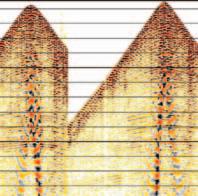
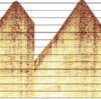
Frequency of the signal defines resolution,the ability to measure the thin pay.In simple terms, a thin reservoir will produce a signal at the top followed almost immediately by a signal from the base and these will travel to the geophone at the surface.If they overlap,the geophone will not be able to separate them and the resultant response will be recorded on the seismic trace.When the signals overlap and interfere,spurious amplitudes can result as seen in the wedge models (Figure 1) The higher the frequency the better the resolution for the thin bed,but there is a practical limit involved.Frequency diminishes with depth so resolution reduces accordingly.
The following relationship defines the tuning response or limit of resolution:
Thickness = Interval Velocity / 2.8 x frequency
Since we want any measured Z to be small,i.e., high resolution,we would prefer the velocity in the numerator to be small and the frequency in the denominator to be high. Hence,high resolution seismic is synonymous with high frequency.
PHASE AND CALIBRATION
Signal phase is the most elusive parameter.The industry has a preference for zero phase (i.e., symmetrical signals) but there are times when the phase cannot be accurately corrected.
Phase is critical in calibrating seismic data to synthetic seismograms made from sonic and density logs and in the process of inversion where trace data is integrated to produce synthetic acoustic logs.When the phase is mistakenly shifted through 180 degrees (i.e., polarity inverted),serious misinterpretation can occur.Predicted “soft” reservoirs can turn out to be hard volcanic layers.
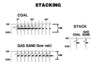
INTERPRETATION OF STACKED DATA
Each signal attribute,amplitude,frequency,and phase,is averaged during the process of stacking (Figure 2).Therefore,stacked (migrated) data is most valuable for structural interpretation while the most useful stratigraphic information is derived from the
Figure 10-2.Stacking averages signal attributes (courtesy:Mike Graul).
Figure 10-1.Wedge models (courtesy:Penny Colton).
original attributes and is commonly interpreted in the pre-stack domain.
In addition,there is a serious problem with ambiguity of signature on stacked sections.In the same way that sonic and density logs without the benefit of gamma ray and other logs cannot distinguish gas-bearing sand from coal or gas-bearing dolomite from shale, stacked data cannot distinguish reservoir from non-reservoir in both clastics and carbonates. This problem has occurred repeatedly in the exploration evolution of the Western Canada Basin when coals were mistaken for Colony gas sands and shales for Swan Hills porosity with gas.Clearly,the “bright spot” or amplitude anomaly is not enough to identify reservoirs in the Colony.Likewise,the “bright spot” approach to reservoir identification in consolidated formations,such as the Viking and Glauconite,also failed to a large extent.
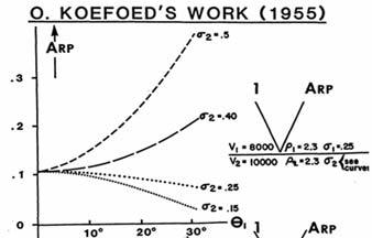
In 1955,a young Dutch geophysicist called Otto Koefoed working at Shell Research published a paper suggesting that valuable stratigraphic information was available by observing how the amplitude of the reflected p-wave varied according to the angle of incidence at the boundary.He had applied the classical Knott-Zoeppritz equations for earthquake physics to typical exploration models involving clastic and carbonate reservoirs and demonstrated that each case had a unique behaviour in terms of this amplitude variation (Figure 3).He predicted that in the future this might be a powerful stratigraphic tool.
In 1955,however,the seismic industry was not aware of “stratigraphy” and was busy chasing structure.In addition,seismic data at this time was all 100%,i.e.,single fold.Stacking had not yet been invented.In 1956,Harry Mayne suggested the stacking process and this was quickly adopted by the industry and the Koefoed approach was rendered obsolete.His research sat in obscurity until Ostrander of Chevron presented his seminal paper on (Continued on page 28...)
Figure 10-3.Koefoed Curves (courtesy:Mike Graul).
(...Continued from page
Amplitude versus Offset (A.V.O.) in 1982. Since then the Koefoed approach has gained enormous status.
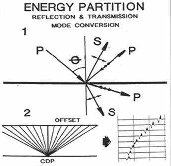
The theory hinges on the classical understanding of earthquake behaviour in terms of both p- and s-waves at major boundaries in the earth,such as the Moho (Figure 4).When a compressional p-wave hits a boundary at an angle other than perpendicular, there is a partial conversion to shear (s-wave) as well as normal reflection and transmission. This is controlled by the Poisson’s Ratio of the rocks above and below the boundary and it became evident that this is the most dominant seismic parameter.At different angles of incidence there is different mode conversion
resulting in a variation in the amplitude of the reflected signal.This behaviour is best observed on shot records or CDP gathers where the data is in pre-stack mode and the amplitude of the signal as a function of offset can be interpreted (Figure 5).
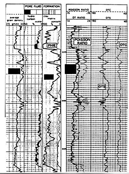
It is important to point out that logging companies record array or dipole sonics by measuring the transit times of both the p- and s-wave sonic logs and converting to a Poisson’s Ratio log for purposes of defining the matrix lithology,pore volume, and fluids (Figure 6).Therefore,it seems reasonable to measure the varying amplitude of the p-wave in seismic,measure or deduce the swave component,and generate the same lithological predictions.
Poisson’s Ratio varies from liquids (0.5) to rocks (0.1 to 0.4) and gases (0.01) and it is possible to measure these values to distinguish various rock types and their porosity/gas content.It is therefore a petrophysical parameter as well as a seismic parameter.
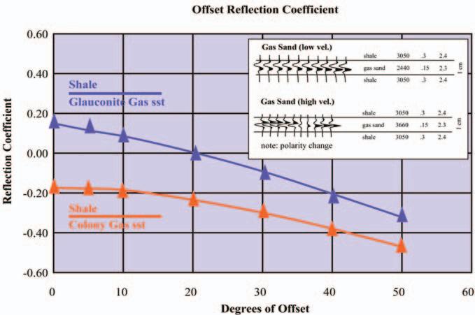
There was immediate success in applying the technology after the Ostrander revelation.In western Canada,it became possible to distinguish Colony-type gas sands from coal (Figure 7).However there was considerable scepticism about the potential benefit in carbonate reservoirs in that they
were considered to be too deep.This changed when pre-stack seismic data over the Caroline Swan Hills gas discovery in 1987 showed a diagnostic offset amplitude behaviour.Thus,the methodology was shown to be applicable to both clastic and carbonate gas reservoirs.
This approach involves pre-stack analysis and interpretation.In general,the pre-stack data quality is noisy,without the benefit of the stacking filter.Thus other,less compromising, noise reduction techniques are necessary to improve the S /N ratio and allow investigation of the signal behaviour.
The volume of pre-stack as opposed to poststack data makes the process extremely time consuming and requires the use of a workstation with the necessary analytical and interpretive software that can handle the prestack data volumes.This procedure should be done for both 2D and 3D data sets.
Note:Questions on this and previous articles are invited.Please send any question by e-mail to the author at eastonw@telus.net.A selection of questions with answers will be published regularly.
Figure 10-5.AVO response in gas sands.
Figure 10-7.Coal and Colony gas sand AVO responses (courtesy:John Varsek).
Figure 10-6.Dipole sonic log example (Schlumberger).
Figure 10-4.Reflection at an angle (courtesy:Mike Graul).
27)
CSPG STRUCTURAL DIVISION FIELD TRIP, 2005
BY ELIZABETH ATKINSON, STRUCTURAL DIVISION CHAIR
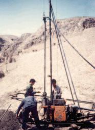
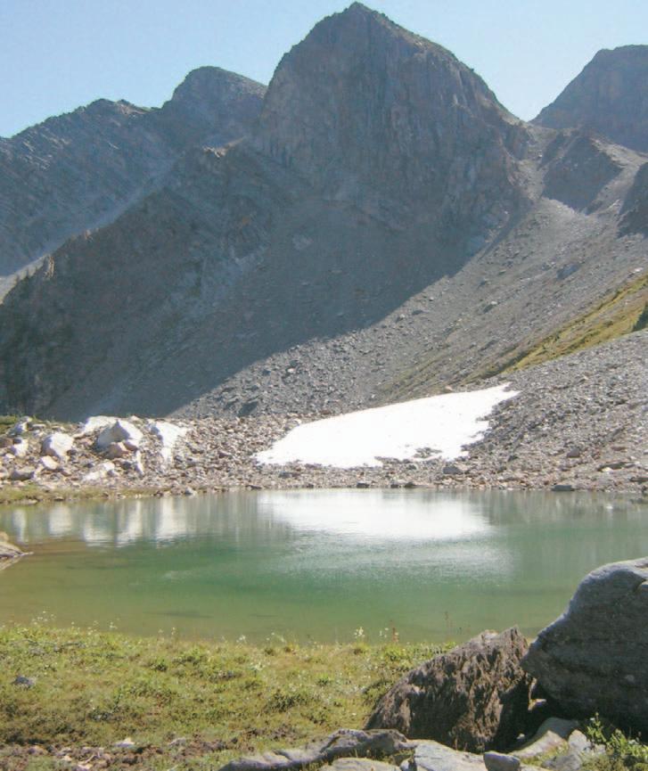
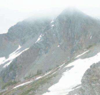
On August 27,a group of 17 people gathered to again attempt to admire the geology of Dauntless Mountain,in the Dogtooth Range of the Purcells.Last year Mother Nature did not treat us well and we were rained out,but this year she made up for it.The day was sunny and beautiful, and we were able to make our way high onto the mountain to see Cambrian and Eocene extension,Laramide trusting,and a diatreme.Thomas Kubli did an excellent job,leading the group through what was once his thesis area.Thanks also to trip sponsors:Petro-Canada,Shell,HEF Petrophysical Consulting,and IHS Energy (as sponsor of the CSPG Technical Divisions) covered vehicles,and Suncor bought dinner.It was great to finally get to such a geologically interesting and beautiful place.
Photo Captions:View of the diatreme.
The Canadian Society of Petroleum Geologists in association with The Canadian Society of Exploration Geophysicists and The Association of Professional Engineers, Geologists and Geophysicists of Alberta presents The 2005 Honorary Address:
Guest Speakers: Bob McDonald, CBChost of Quirks and Quarks and Dr. Kirk Johnson, Chief Curator,Denver Museum of Nature and Science.
November 7, 2005. Doors open at 5:30 pm. Southern Alberta Jubilee Auditorium. Tickets available at Ticketmaster: 777-0000 or www.ticketmaster.ca. Adults $10, Students, Seniors, and Groups $6. More info at: www.cspg.org.
Thank you to our Sponsors:
Photo: Brian Atkinson / CanadianFocus
Photo: Visti Kjar
PROSPECT SASKATCHEWAN: THE SENATE POOL
This article is reprinted with permission from the Prospect Saskatchewan informational brochure series.The series is intended to highlight prospective areas in order to further develop the oil and natural gas resources of Saskatchewan. Further information may be obtained by emailing:prospectsask@ir.gov.sk.ca.
A Model for Shoreface Sand Exploration in Southwestern Saskatchewan
INTRODUCTION
Large undiscovered reserves of natural gas are thought to exist in shallow,lowpermeability Cretaceous sandstones, siltstones,and shales of Saskatchewan. Industry interest in the exploration for these shallow biogenic-gas targets has been sparked by high natural gas prices and,more importantly,by the recent discovery of the extensive Abbey-Lacadena gas pools hosted in fine-grained Alderson (Milk River) strata in the Shackleton area of southwestern Saskatchewan.The geological framework of Cretaceous strata in Saskatchewan and the geological controls on the genesis and distribution of shallow,low-permeability biogenic-gas systems are still being unraveled. As such this play offers potentially significant rewards across this immense region.
BY STAFF GEOLOGISTS, PETROLEUM BRANCH, SASKATCHEWAN INDUSTRY AND RESOURCES
Shallow gas in southwestern Saskatchewan is mainly hosted in fine-grained siliciclastic reservoirs within the Belle Fourche Formation (commonly referred to as “Second White Specks sandstones”),the Medicine Hat Member of the Niobrara Formation,and the Alderson Member (Milk River Formation). Many shallow gas accumulations exhibit
characteristics such as large areal extents, poorly constrained boundaries,low overall reservoir permeability,and stratigraphic proximity between source and reservoir rocks,that are typical of unconventional, continuous-type reservoirs.Recent works suggest a subtle structural influence may be present in some accumulations.Another type of shallow gas accumulation,however,occurs in narrow,elongate,and well-defined pools. The Senate and Merryflat pools in Belle Fourche sandstones are examples of these, and this brochure will outline the rationale for finding more pools of this type.
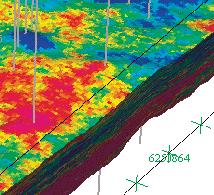
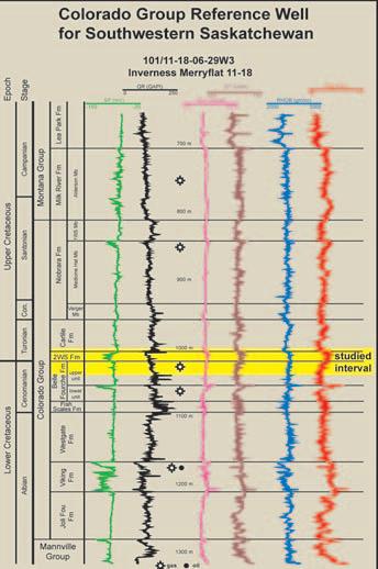
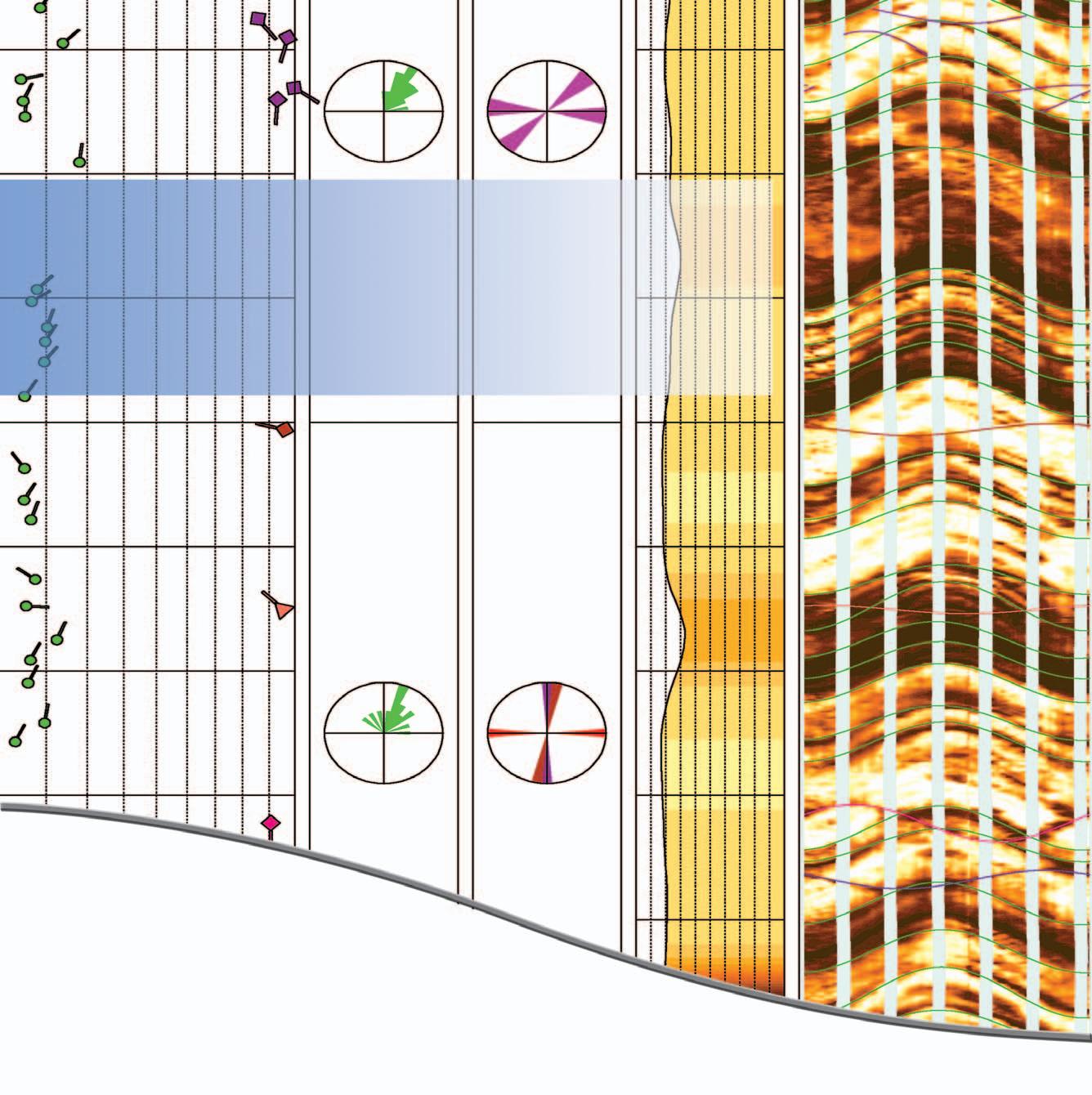
REGIONAL GEOLOGY
Figure 1 is a typical log response to producing wells in the Senate or Merryflat 2WS pools.The interval of interest, highlighted in yellow,includes the Second White Specks Formation (2WS) and the upper portion of the Belle Fourche Formation,which contains a sandstone package also known as the 2WS sandstones. A regional unconformity near the base of the 2WS sandstones has important implications for hydrocarbon entrapment.
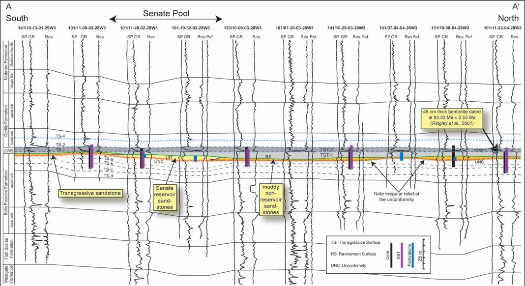
Cross-section A-A’ (Figure 2) shows the significance of this unconformity and its related relief both to the architecture of the Senate Pool and to the development of further exploration strategies.
Figure 1.Typical log response in the Merryflat Pool.
Figure 2.Cross-section A-A’through the Senate Pool.
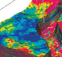
The Senate Pool is one of a series of Belle Fourche gas accumulations located on the eastern flank of a major north-south oriented structural high in southwestern Saskatchewan (Figure 3).Gas in the Senate Pool is hosted in Late Cenomanian sandstones of the upper unit of the Belle Fourche Formation (Second White Specks sandstone and Mosby/Upper Phillips Sandstone equivalents).Recent regional well-log correlations in Saskatchewan have indicated the presence of a major regional unconformity that truncates progressively older Belle Fourche strata to the north and east.A dense grid of detailed core and welllog cross-sections reveal that the Senate reservoir sandstones overlie this unconformity and are in turn overlain by tight calcareous deposits of the Second White Specks Formation.As the unconformity is characterized by low-angle truncation of underlying strata,a distinctive flooding surface within the Second White Specks Formation is used as datum on the cross-sections.The flooding surface (datum) is overlain by up to 60 cm of bentonite that forms a distinct marker bed both in cores and on well logs.Cross-sections show both irregular,low-angle truncation of Belle Fourche strata below the unconformity and onlap of strata onto the unconformity,
indicating the original topographic relief of this surface.
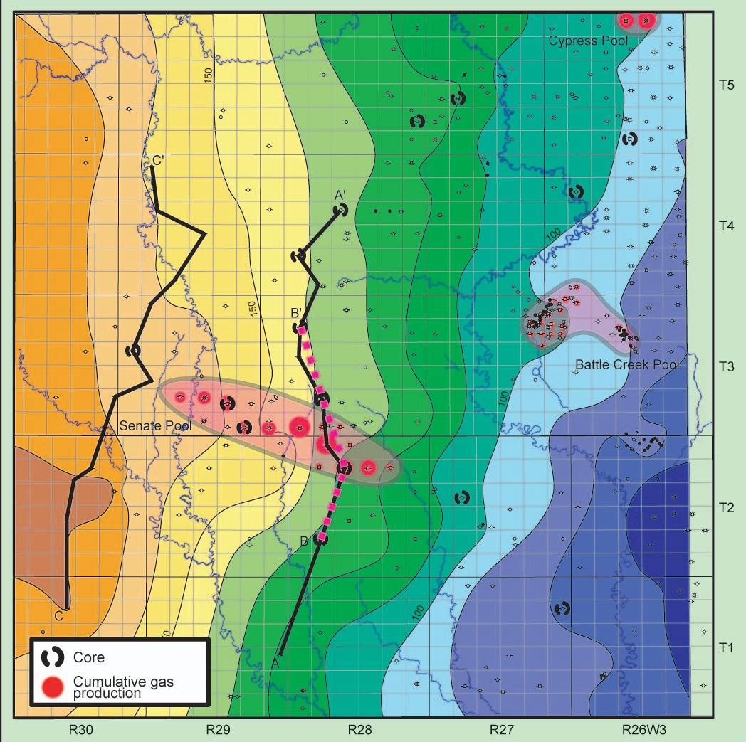
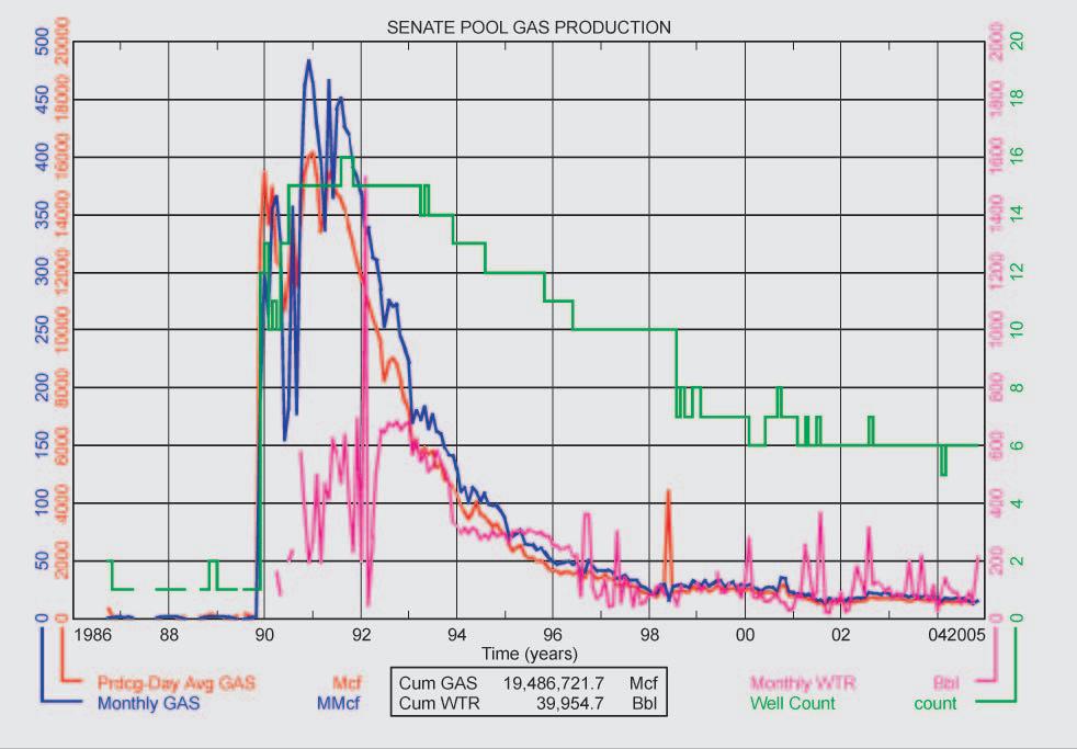
The Senate Pool is among the most prolific Belle Fourche gas pools in Saskatchewan (Figure 4).As of January 2005,total production was almost 5.5 x 10⁸ m3 (19.4
bcf).Discovery well PAI Senate 101/11-2802-28W3,drilled in 1971,only commenced production in late 1986.By January 1991, production from 15 wells was more than 453,000 m3/day (16,000 mcf/day).Initial production from SPC et al Senate 07-12-0329W3 exceeded 56 634 m3/day (2,000 mcf/day),and total gas production through January 2005 surpassed 7.7 x 10⁷ m3 (2.75 bcf),making it one of the top single-well producers in Western Canada from the Belle Fourche Formation and equivalent 2WS sandstones.
ECONOMIC POTENTIAL
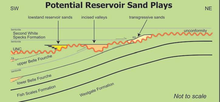
The presence of a major unconformity (Figure 5) just below the base of the Second White Specks Formation opens the potential for several different gas plays associated with the unconformity:1) sandstone bodies associated with development of the unconformity either as forced regression/lowstand sandstones or as narrow incised valley fills,and 2) transgressive reworked sandstones associated with the Second White Specks transgression (similar to the Senate reservoir sandstones).These plays are probably not limited to southwestern Saskatchewan where they have traditionally been explored for.As the unconformity cuts deeper towards the east and north, potential plays may also exist in central and eastern Saskatchewan (Figure 6).The Petroleum Geology Branch of SIR is continuing research into these unconformity-related gas plays and other potential hydrocarbon plays within the Colorado and Montana groups of Saskatchewan.
(Continued on page 35...)
Figure 4.Senate Pool Gas Production.
Figure 3.Second White Specks Structural Map.
(...Continued from page 33)
SUMMARY
Analog:Senate Pool with natural gas in transgressive shoreface sandstones of the upper Belle Fourche Fm.Reservoir has 15-30% porosity and up to 340 mD permeability.
Prospective Trap:Shoreface sandstones; incised valleys;and lowstand deposits on the flanks of 2WS structural highs.
Seal:Calcareous-rich shales and bentonites within the 2WS Fm.
Source:Biogenic
REFERENCES:
Pedersen,P.K.(2004):Shallow gas research project in southwestern Saskatchewan:Revised lithostratigraphy of the Colorado Group and reservoir architecture of the Belle Fourche and Second White Specks in the Senate Pool;in Summary of Investigations 2004,Volume 1, Saskatchewan Geological Survey,Misc.Rep. 2004-4.1,CD-ROM,Paper A-16,15p.
Ridgley,J.L.and Gilboy,C.F.(2001): Lithofacies architecture of the Upper Cretaceous Belle Fourche Formation, Saskatchewan,Alberta,and Montana - Its relationship to sites of shallow biogenic gas production;in Summary of Investigations 2001,Volume 1,Saskatchewan Geological Survey,Misc.Rep.2001-4.1,106-120.
Download the above documents and other information related to hydrocarbon resources of Saskatchewan at:http://www.ir.gov.sk.ca/ subsurfacelab,Email:prospectsask@ir.gov.sk.ca
Although the Department of Industry and Resources has exercised all reasonable care in the compilation,interpretation and production of this brochure,it is not possible to ensure total accuracy,and all persons who rely on the information contained herein do so at their own risk.The Department of Industry and Resources and the Government of Saskatchewan do not accept liability for any errors,omissions or inaccuracies that may be included in,or derived from,this brochure.
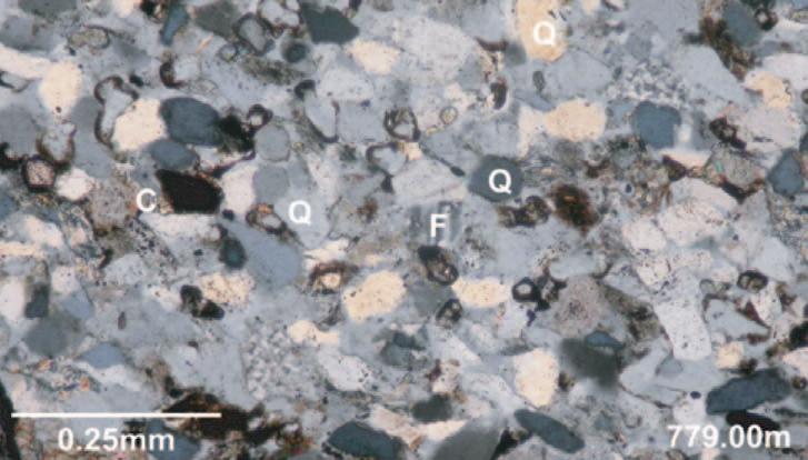
Figure 7.Thin-section photomicrograph of the upper Belle Fourche reservoir sandstone from 7-11-3-29W3 in the Senate Pool.The reservoir is a very fine- to finegrained sandstone with 75% quartz (Q),20% carbonate (C),5% fine matrix and trace feldspar (F). Core analyses indicate this interval has from 15 to 30% porosity,and permability up to 340 mD.
Figure 6.Areas of Potential Reservoir Sands.
Figure 5.Unconformity-Related Gas Plays.
MEANDER BELT ENTRAPMENT OF HYDROCARBONS
BY RALPH EDIE AND JOHN ANDRICHUK
Meander Belt Entrapment of Hydrocarbons, Campbell-Namao Field, Alberta
The following abstract and figures have been excerpted from an unpublished paper by Ralph W.Edie and John M.Andrichuk.A copy of the complete paper,including 27 Figures,is on file at the Gallagher Library,University of Calgary and is also available on the AAPG’s Search and Discovery website (http://www.searchand discovery.net/documents/2005/edie/index.htm).
The reference to it is:Edie,Ralph W.,and John M.Andrichuk,2005,Meander Belt Entrapment of Hydrocarbons,Campbell-Namao Field, Alberta:Search and discovery Article #20029, PDF version.
At Campbell-Namao Field,near Edmonton, Alberta,Lower Cretaceous uppermost Ellerslie Member hydrocarbon-bearing quartz sandstone reservoirs include sandstone bodies with markedly different shapes and origins as follows:
(1) approximately 20-metre-thick sandstone bodies,with an areal extent as great as 518 hectares (2 square miles),that exhibit ìfining-upwardî response on electric logs and are interpreted as point bar sandstones along a river meander belt.
(2) thin sheet sandstones (5 metres thick) of relatively uniform thickness and widespread areal extent,interpreted as being of marine origin.
Within the interpreted meander belt,there are numerous point bar sandstone bodies, some (but not all) of which contain stratigraphically entrapped hydrocarbons.A roof-seal is provided by a widespread shaly bed.Up-dip,lateral,and down-dip sealing is provided by shale-filled channels or oxbows that locally completely surround the point bar sandstone bodies.
Within the interpreted meander belt,14 shale-filled channels were intersected in boreholes.In the central portions of the shale-filled channels,the compacted shale filling,as measured on electric logs,varies from 14.6 to 23.5 metres (48 to 77 feet).
Gas and oil were entrapped in compartmentalized reservoirs and each compartment (point bar or point bar remnant) is characterized by a measurably different subsea gas-oil or oil-water contact.
Figure 13.Cross-section O – O’showing the shape and continuity of the most extensive point bar reservoir sandstone in Campbell-Namao Field.For location of section see Figure 14.
Figure 14.Areal extent of hydrocarbon-bearing upper Ellerslie Member point bar sandstones,or remnants of point bar sandstones,(surrounded by shale-filled channels) based on differences in thickness of oil columns and differences in subsea elevations of gas-oil and oil-water contacts,Campbell – Namao Field,Alberta.
Figure 19.Section J – K along upper Ellerslie Member meander belt,Campbell – Namao Field,Alberta,showing stratigraphic and structural entrapment of hydrocarbons.For location of section see Figure 14.
Figure 25.Cross-section E – F through northwestern part of Campbell – Namao Field showing stratigraphic entrapment of gas and oil.(All boreholes shown are in Township 54 Range 25 W4M).For location of section see Figure 14.
(...Continued from page 36)
Maximum gross pay thickness is 27.4 metres (90 feet).In several parts of the meander belt,interpreted point bar sandstones are mainly water-bearing:only point bar
sandstones or remnants of point bar sandstones that are completely surrounded by shale-filled channels appear to trap commercial quantities of hydrocarbons.
Hydrocarbon entrapment within the thin sheet sandstones is caused by:
a) up-dip and lateral facies change from permeable sandstones to shaly beds;
b) up-dip and lateral truncation of the thin sheet sandstones by shale-filled deeply entrenched meandering river channels along the concave down-dip edge of the meander belt.
Within the field area,the hydrocarbonbearing portion of the thin sheet sandstones cover an area of 2331 hectares (9 square miles).However,the water-bearing segments of these sandstones extend over a much greater area,beyond the field limits.Total production at Campbell-Namao Field,from both point bar and thin sheet sandstone reservoirs,to the end of March 2002,is 3183 x 106 m3 (113 Bcf) and 922 x 103 m3 (5.8 million barrels) of 33∞ A.P.I oil.
In central Alberta,upper Ellerslie meander belts are mapped from electric logs with relatively sparse well control.In exploratory drilling,along those meander belts, hydrocarbon reserves similar in size to those in productive point bar sandstones at Campbell-Namao Field (i.e.,5.8 Bcf gas and 258,000 bbls oil per square mile) can be expected.Moreover,if ìbright spotî seismic technology to map upper Ellerslie Member gas accumulations (with or without associated oil columns) can be improved,it should be possible to attain almost 100% success in exploratory drilling along known upper Ellerslie meander belts.
The exploration procedure outlined applies to meander belts of various ages worldwide,provided that:(1) the point bar sandstones retain their porosity and permeability,(2) source rocks at sufficient depth and temperature are available to generate hydrocarbons,and (3) the point bar sandstones have a roof-seal.
Figure 14 is a map of the Campbell-Namao Field area showing the location of cross sections O – O¢ (Figure 13),J – K (Figure 19) and E – F (Figure 25).Figures 13 and 19 illustrate internal meander belt entrapment of hydrocarbons whereas Figure 25 illustrates external meander belt entrapment.
SIFT REUNION
During the 2005 AAPG convention,a reunion was held for all past SIFT attendees and committee members.Over 80 people attended the event at the Rotary House at the Stampede Grounds. Attendees included participants from the inaugural 1977 trip,up to the latest group of 2005 SIFT-ies.Many thanks go to Encana and OilExco for sponsoring this event.
SIFT began nearly 30 years ago,as an attempt to attract students to the oil patch.This year’s reunion was the start of an effort to find out what has happened to all those participants.The CSPG Educational Trust Fund (Trust) Board is interested in following the career paths of over 900 former participants to determine the efficacy of the SIFT program.
The Trust’s Board has been able to piece together a list of participants from the past 28 years.It was amazing to find what some people still had tucked away – perhaps Geologists are pack rats – but we are thankful for it.We are still missing information on four years and hope that Reservoir readers can help.If you know who attended from your university or can help us match these names with universities,please contact SIFTReunion@telus.net
SIFT 2005 Alumni:Luis Bayona (McGill),David Ross (UBC),Sarah Duguid (Memorial), Paul Leduc (Carleton) & Kevin Root (SIFT Trip Leader)
At the Calgary TELUS Convention Centre
January 5th -7th 2006
For the last forty-two years, the Western Inter-University Geological Conference has served as a forum for students studying the Earth Sciences.
Delegates from across Western Canada will converge in Calgary this winter to present their research, participate in discussion, and to network with industry professionals.
We hope you will join us in welcoming this event to our city!
If you would like more information or to become involved in WIUGC 2006, please visit http://www.wiugc2006.info
1980Alan TambossoUniversity of Toronto
1980Doug BearingerUniversity of Waterloo
1980Vincent FeraUniversity of Western Ontario
1980Gary CaldwellUniversity of Windsor
1980Anne-Marie Wawrzkow ?
1980Georges Dagenais?
1980Nancy Campbell?
1980Nicholas Spence?
1980Doug Furey?
1980Michel Rousseau?
1980Martin Froelich?
1980Claire Derome?
1980Shirley Frenette?
1980Robert Harrison?
1980Susan Jenkins?
1980John Hoess?
1986Brian EddyAcadia University
1986Clark LoganBrandon University
1986?Brock University
1986Susan KeddieCarleton University
1986Mark ShoreConcordia University
1986Gordon CheckDalhousie University
1986Rod RezkaLakehead University
1986Stewart HamiltonLaurentian University
1986Isabelle McMartinLaval University
1986Anne SassoMcGill University
1986?McMaster University
1986Margot Davis Memorial University of Newfoundland
1986?Mount Allison
1986?Queen’s University
1986Darren DavidSaint Mary’s University
1986Sarah PalmerSaint Mary’s University
1986Ann MelvinSt.Francis Xavier University
1986?Universite du Quebec à Chicoutimi
1986?Universite du Quebec à Montreal
1986Robert CarssUniversity of Alberta
1986George SzeferUniversity of British Columbia
1986Blair RosquistUniversity of Calgary
1986?University of Guelph
1986Doug BellUniversity of Manitoba
1986?University of Montreal
1986?University of New Brunswick
1986Terry SamiUniversity of Ottawa
1986?University of Regina
1986Tim HudemaUniversity of Saskatchewan
1986Blair HrabiUniversity of Toronto
1986David A.ThomasUniversity of Waterloo
1986Jennifer WadsworthUniversity of Western Ontario
1986Ray NothdurftUniversity of Windsor
1986Catharine Goddard?
1986Cecilia Howkins?
1986Charlie Robinson?
1986Doug MacKenzie?
1986Francine Gaudard?
1986Jean-Guy Lacasse?
1986Jill Rehman?
1986Leisa McCavour?
1986Yves Savard?
1989?Acadia University
1989?Brandon University
1989?Brock University
1989John Gillette?Carleton University
1989?Concordia University
1989?Dalhousie University
1989?Lakehead University
1989?Laurentian University
1989?Laval University
1989?McGill University
1989?McMaster University
1989Janet Dunphy Memorial University of Newfoundland
1989?Mount Allison
1989?Queen’s University
1989?Saint Mary’s University
1989?St.Francis Xavier University
1989?Universite du Quebec a Chicoutimi
1989?Universite du Quebec a Montreal
1989Roy HaggertyUniversity of Alberta
1989?University of British Columbia
1989Brian FykeUniversity of Calgary
1989?University of Guelph
1989?University of Manitoba
1989?University of Montreal
1989?University of New Brunswick
1989Sari Burgoyne University of Ottawa (nee Penny)
1989?University of Regina
1989?University of Saskatchewan
1989?University of Toronto
1989Kim VooroUniversity of Waterloo
1989?University of Western Ontario
1989?University of Windsor
17TH ANNUAL CSPG/CSEG 10KM ROADRACE AND FUN RUN
BY FIONA KATAY, RACE DIRECTOR
This year’s race was held on Wednesday, September 14,and turned out to be a very pleasant evening,filled with enthusiasm and fun.The course started at Eau Claire and took runners along the Bow River pathway on the south side of the river.Many runners were seen to be trying to chase down their co-workers in friendly competition in this 10km event.It was great to see so many runners out this year,and we hit a record number with 198 registrants! Like every year, it’s great to see that we had runners of all abilities,some seasoned and speedy runners, as well as some first-time racers.The postrace social was held at Quincy’s,where the racers and volunteers attempted to devour their weight in pizza and numb their aches with refreshments while awards and prizes were being given out.
Many thanks go out to the volunteers and sponsors,without whom this event is not possible.Great job as well to everyone who ran!
Special thanks go out to this year’s race committee for all your efforts:Stuart Mitchell,Gillian Bishop,Cindy Koo,Dorothy Chen,Vic Urban,Kathy Taerum,Christine Manion,Mark Shaw,Anne McIntyre,Sarah Marshall,and Kim Maclean.
The results can be found by clicking on the link at http://www.cspg.org/social_00.html. Here’s a summary of the CSPG,CSEG and CAPL winners from this year’s race:
The leaders charging their way along the Bow River pathway.
198 runners participated,including Boe Baskerville (right) and Douglas Vanbeselaere (centre).
Murray Joa and Fiona Katay,2005 Race Director.
2006 CSPG CSEG CWLS JOINT CONVENTION
WHAT’S NEXT? Where is our industry heading? The 2006 CSPG CSEG CWLS Joint Convention,is now accepting Abstracts for Oral Presentations,Poster Presentations, Core Displays as well as Field Trips and Short Courses.
All abstracts must be submitted online at www.GEOconvention.org following the guidelines outlined in the Call for Abstracts, also available on the website.The deadline to submit is January 31,2006 - don’t delay,submit today! Late submissions will not be accepted.
For more information,please contact the Technical Co-Chairs:
Allan Pickel (CWLS) (403) 269-8172 apickel@suncor.com
CALL FOR EXHIBITORS OPENS NOVEMBER 1ST!
With the three societies partnering once again,there is a high demand of exhibit floor space.The 2006 Convention will be offering close to 100,000 square feet of exhibit space to companies wishing to profile their products and services to our estimated 3,000 delegates.Space is going to fill up fast, be sure to submit your application right away!
All exhibitor applications will be accepted starting November 1st.The Exhibits Committee is hard at work contacting past and potential exhibitors over the next few months,for further details and the complete exhibitor package & application visit www.GEOconvention.org.
If you have any questions or would like more information about the Exhibits program, please contact Matt Earle,Exhibits Chair at (403) 781-1704 or mearle@arcis.com.
CALL FOR SPONSORSHIP!
Invest in this year’s 2006 CSPG-CSEG-CWLS joint convention – “What’s Next?” Position your organization as an industry leader and strategically align yourself with these three societies to provide a premier technical event for Canadian geoscience professionals.
Sponsorship opportunities include the Keynote Luncheon,Delegate Bags,Technical Halls, Student Sessions,Speakers’ Breakfast,Coffee Stations,Ice Breaker,Special Events,and more! Visit www.GEOconvention.org for the complete sponsorship package and application.
For further information regarding sponsorship opportunities,please contact Mike Seifert, Sponsorship Chair at (403) 517-3267 or mseifert@reconpetro.com.
WHAT’S NEXT?
WHERE IS OUR INDUSTRY HEADING?
#160,540 – 5th Ave SW Calgary,AB T2P 0M2 Tel (403) 264-5610 Fax (403) 264-5898 www.GEOconvention.org Submit your photographs for our upcoming photo exhibit celebrating the International Polar Year and the role of Petroleum Geologist in the artic.
Selected works will be included in an exhibition and silent auction with proceeds going to the CSPG's educational initiatives.
Deadline for email submission of 3 low resolution images per entrant December 15th, 2005. Send to kim.maclean@cspg.org
Upon inclusion in the show you will receive instructions for submission of your unframed, original photograph.
The EARTH ImagerSM service delivers high-resolution micro-resistivity images in oil-based mud with great hole coverage.
This proven micro-resistivity imager from Baker Atlas offers a vertical resolution of less than 8mm at a standard logging speed of 274m/hr giving you details never seen before in oil-based mud images.
The EARTH Imager service operates in 149mm to 533mm diameter boreholes. With its 6 pads mounted on individually articulated arms, it provides you with 64.9% borehole coverage in 200mm diameter holes while maintaining pad contact at all hole deviations.
Call us today to find out how you can use the EARTH Imager service in your next oil-based well to accurately identify structural and sedimentary features, rock texture, fracture orientation and estimate net-to-gross.