■ The Mackenzie Corridor: Access to Northern Resources Project (ESS-GSC)
■ The Mackenzie Corridor: Access to Northern Resources Project (ESS-GSC)
■ CSPG Core Conference June 23-24, 2005
■ CSPG Core Conference June 23-24, 2005
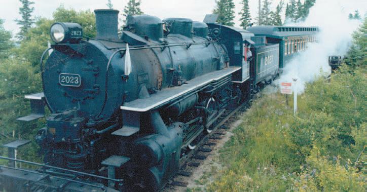
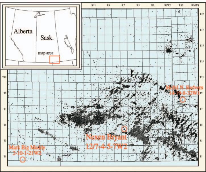
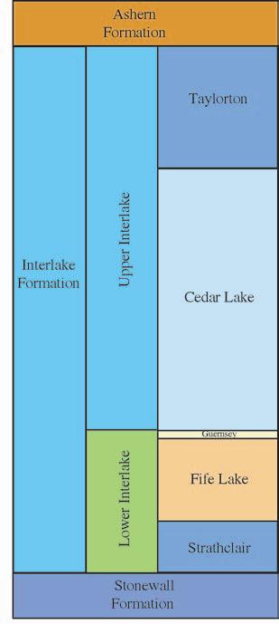
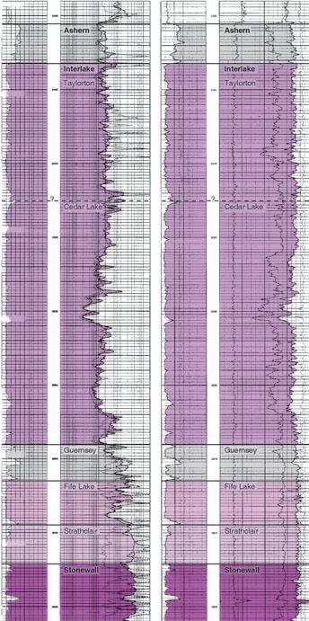
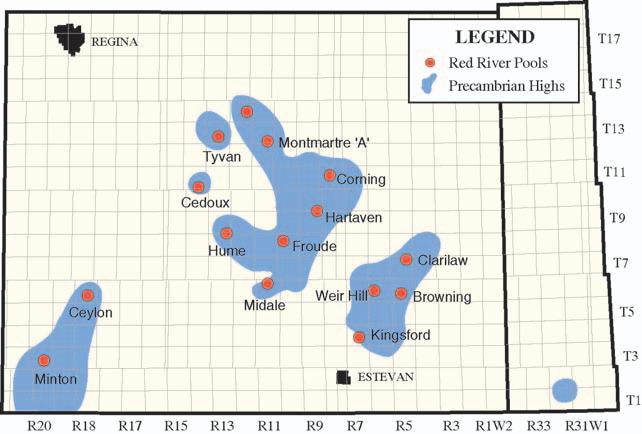
■ Western Canada’s First Silurian Production
■ Western Canada’s First Silurian Production
■ 2005 William C. Gussow Geoscience Conference
■ 2005 William C. Gussow Geoscience Conference
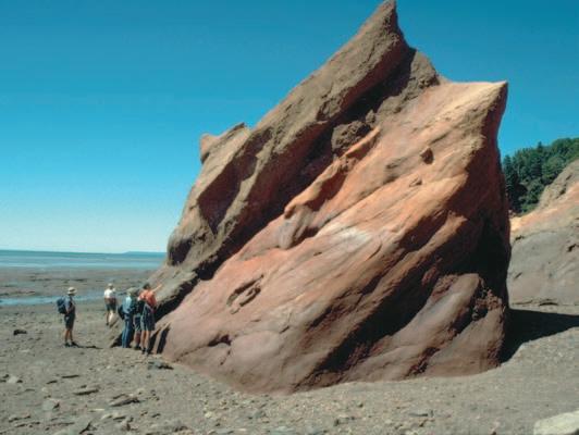
■ Atlantic Universities Geological Conference
■ Atlantic Universities Geological Conference
CSPG OFFICE
#160,540 - 5th Avenue SW
Calgary,Alberta,Canada T2P 0M2
Tel:403-264-5610 Fax:403-264-5898
Web:www.cspg.org
Office hours:Monday to Friday,8:30am to 4:00pm
Business Manager:Tim Howard
Email:tim.howard@cspg.org
Office Manager:Deanna Watkins
Email:deanna.watkins@cspg.org
Communications Manager:Jaimè Croft Larsen
Email:jaime.croftlarsen@cspg.org
Conventions Manager:Lori Humphrey-Clements
Email:lori@cspg.org
Corporate Relations Manager:Kim MacLean
Email:kim.maclean@cspg.org
EDITORS/AUTHORS
Please submit RESERVOIR articles to the CSPG office.Submission deadline is the 23rd day of the month,two months prior to issue date. (e.g.,January 23 for the March issue).
To publish an article,the CSPG requires digital copies of the document.Text should be in Microsoft Word format and illustrations should be in TIFF format at 300 dpi.For additional information on manuscript preparation,refer to the Guidelines for Authors published in the CSPG Bulletin or contact the editor.
COORDINATING EDITOR & OPERATIONS
Jaimè Croft Larsen
CSPG
Tel:403-264-5610 Fax:403-264-5898
Email:jaime.croftlarsen@cspg.org
TECHNICAL EDITOR
Ben McKenzie
GEOCAN Energy Inc.
Tel:403-261-3851
Email:bjmck@telusplanet.net
ADVERTISING
Kim MacLean
Corporate Relations,CSPG
Tel:403-264-5610,Ext 205
Email:kim.maclean@cspg.org
Advertising inquiries should be directed to Kim MacLean.The deadline to reserve advertising space is the 23rd day of the month, two months prior to issue date.All advertising artwork should be sent directly to Kim MacLean.
The RESERVOIR is published 11 times per year by the Canadian Society of Petroleum Geologists. This includes a combined issue for the months of July/August.
Advertisements,as well as inserts,mailed with the publication are paid advertisements.No endorsement or sponsorship by the Canadian Society of Petroleum Geologists is implied.
The CSPG Rock Shop is an attractive and affordable way to target the CSPG readership. Spaces are sold at business card sizes (3.5” wide by 2” high).To reserve space or for more information,please contact Kim MacLean at 403-264-5610,ext.205.
The contents of this publication may not be reproduced either in part or in full without the consent of the publisher.
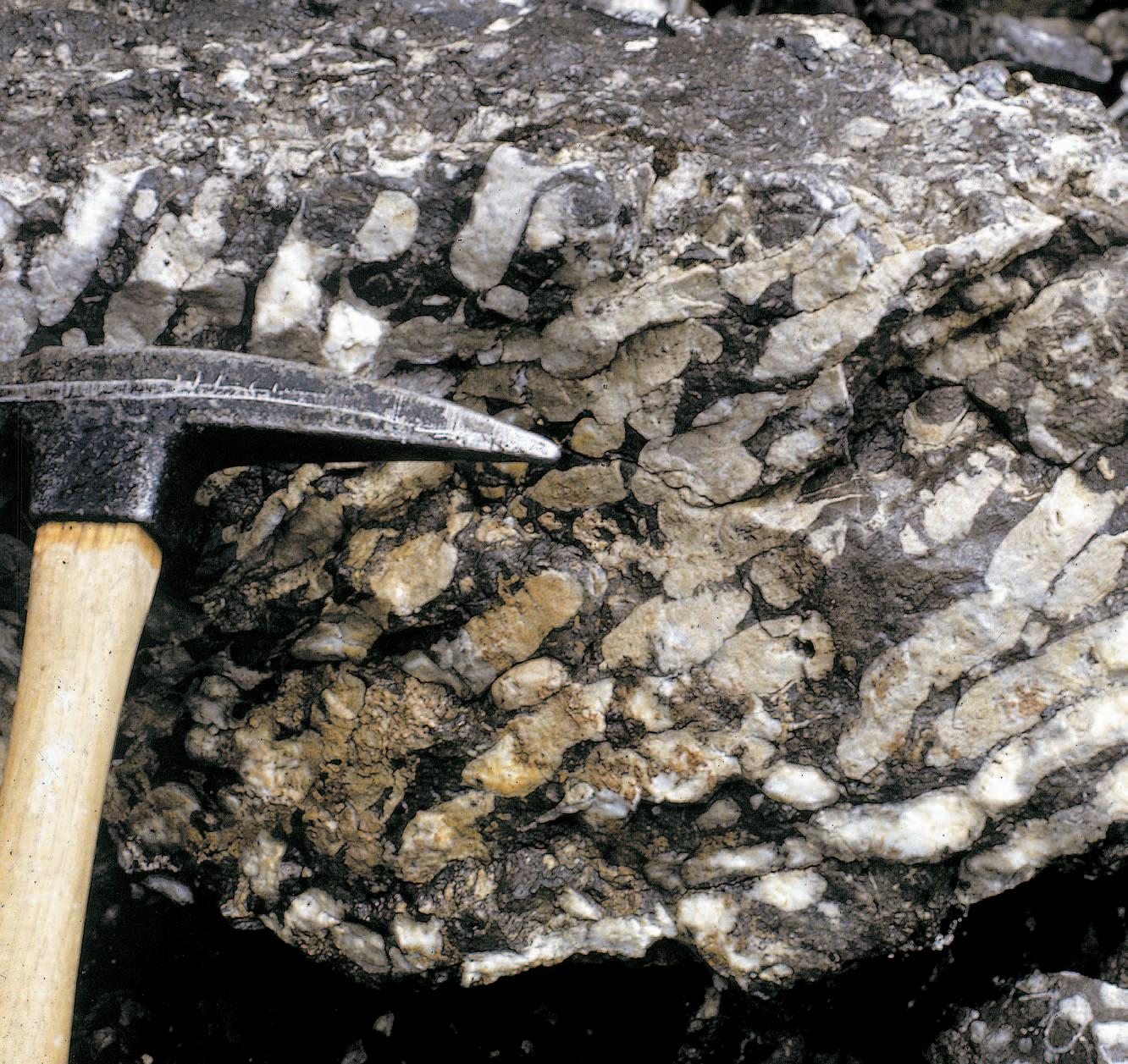
FRONT COVER
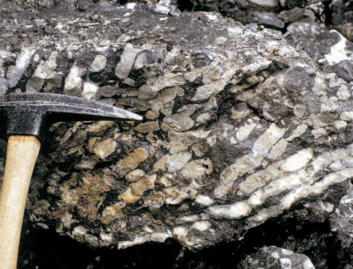
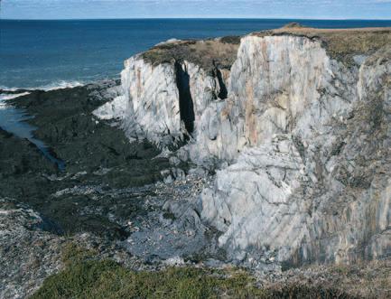
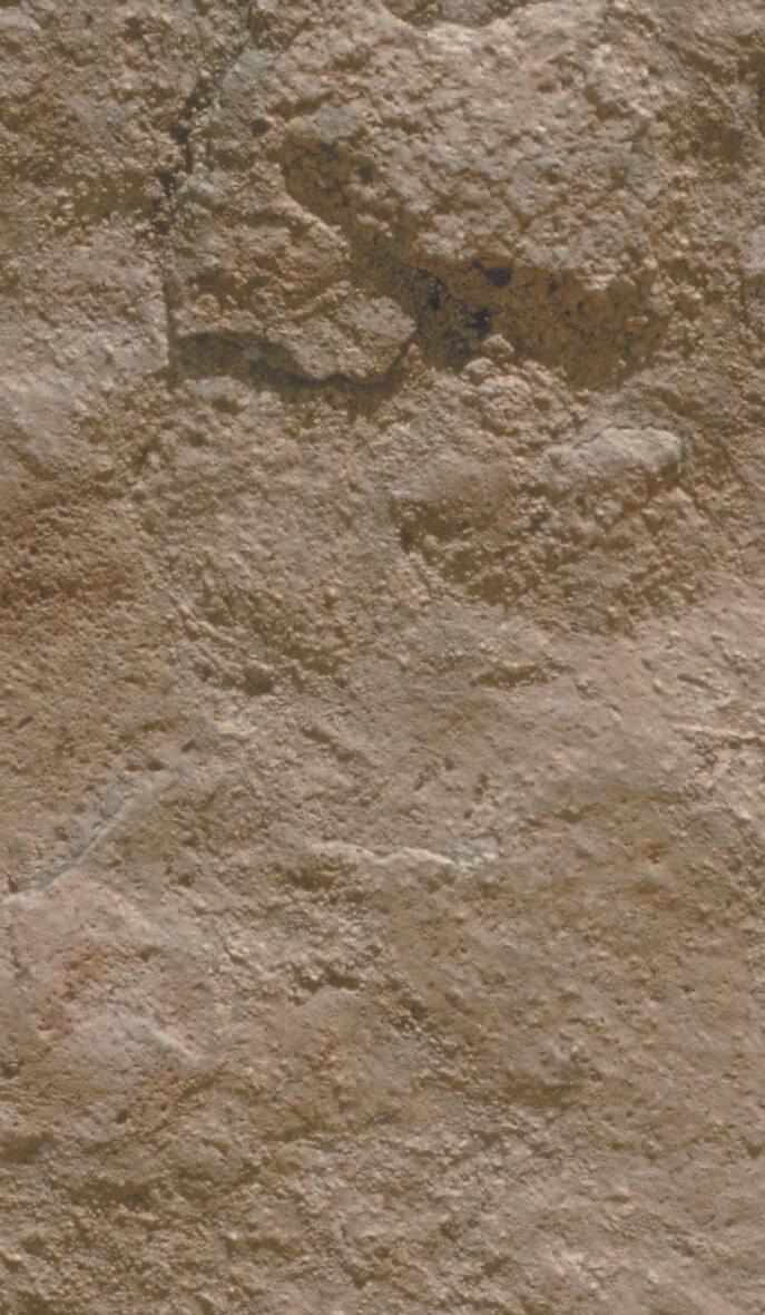
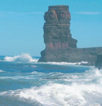
Corals of White Man’s Gap,Canmore,Alberta. Colonial rugose coral from the Upper Devonian (Frasian) Cairn Formation (Leduc equivalent) of the White Man Gap section near Grassi Lakes.Photo by Grant Mossop.
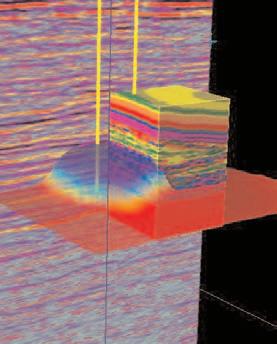
UNCOVER THE CLUES in YOUR Seismic DATA
Boyd PetroSearch helps you get to the bottom of seismic mysteries.
For over 25 years, the team at Boyd PetroSearch has been using a keen eye, deductive reasoning and sharp analytical powers to shed light on countless cases of hydrocarbon exploration - in the Western Canadian Basin and around the world.
A powerful array of hardware and interpretive software helps our professional geophysicists piece together the real seismic story behind oil & gas exploration, reservoir development and gas storage.
Find out how to put Calgary’s most experienced team on your next 2-D, 3-D and 4-D seismic case. Specialists in high-resolution and multi-component seismic sur veys.
TIMES THEY ARE A-CHANGIN’ AND FOR THE CSPG - ELECTRONIC MEDIA IS THE WAY OF THE FUTURE.
As the society prepares for a new website launch in September,we are looking for new ways to bring CSPG publications closer to you and your fingertips.A couple of years ago,the CSPG (in cooperation with the AAPG Datapages) digitized our entire CSPG Bulletin collection (1953-present).It is currently available online through the Corporate Subscription Site of AAPG Datapages in either html or pdf format. Come September,you’ll be able to recycle your Bulletin Collection and simply print off the papers you need from the CSPG Member website.
To digitize a publication,the CSPG must supply three copies;two are destroyed in the process and the third remains intact as a quality check.Each publication is scanned into pdf format and then sent offshore to be hand-typed so it can be viewed in html format.The CSPG archive only contains one copy of each of our publications so we require donations from our members in order to go digital with the rest of our publications.Our next step is to digitize our Memoir Publications.
If you have a Memoir (#1-18) that you would like to donate to this worthy cause, please contact Jaime Croft Larsen at the CSPG Office (264-5610 ext 203) or by e-mail at jaime.croftlarsen@cspg.org.
Another leap forward in Electronic Media was the launch of GeoScience World on February 25th,2005 (www.geoscience world.org).This new electronic publication database was founded by seven earth science societies who collaborated to develop this electronic research resource and is unprecedented in our field of research.The founding organizations were: American Association of Petroleum Geologists (AAPG),American Geological
A MESSAGE FROM THE SERVICE DIRECTOR
Institute (AGI),Geological Society of America (GSA),Geological Society of London (GSL),Mineralogical Society of America (MSA),Society for Sedimentary Geology (SEPM),and Society of Exploration Geophysicists (SEG).
GeoScienceWorld (GSW) will deliver online the aggregated journal content of the founding organizations and of other notfor-profit (i.e.,CSPG) and independent earth science publishers.With time,other material such as maps,books,and digital geoscience data will be included or interlinked.This database will be a comprehensive Internet resource for research and communications in earth sciences,built on a core database aggregation of peer-reviewed journals indexed,linked,and inter-operable with GeoRef.
You can enter search parameters in GeoRef on the website and view and print papers in either html or pdf format.No more trips to the library or the photocopier! It gets better;with the Millennium Collection (2002 onwards),the references will also be interlinked.Research just got a whole lot easier! If your company doesn’t subscribe to GeoScience World – they may want to consider it.
GeoScience World - Launch Collection Journals:
• Geology – Geological Society of America
• Geological Society of America Bulletin –Geological Society of America
• Geosphere – Geological Society of America
• Journal of the Geological Society of London – Geological Society of London
• Rocky Mountain Geology – University of Wyoming
• Geological Magazine - Cambridge University Press
• Bulletin de la Societe Geologique de France - Societe Geologique de France
• South African Journal of GeologyGeological Society of South Africa
• American Mineralogist - Mineralogical Society of America
• Reviews in Mineralogy and Geochemistry
- Mineralogical Society of America
• Clays and Clay Minerals - Clay Minerals Society
• Clay Minerals - Mineralogical Society of Great Britain and Ireland
• Mineralogical Magazine - Mineralogical Society
depths
CONTOURING
Faulted contours
Isopachs
Volumetrics
Grid operations
New flexing options
CROSS SECTIONS
New Unassigned Tops
Digital and/or Raster
Geocolumn shading
Stratigraphic/Structural
Shade between crossover
Dipmeter data
MAPPING OPTIONS
Expanded GIS Functions
Bubble maps
Production charts
Log curves
Posted data
Highlighted Symbols
CROSS PLOTS
Log crossplots
“Z” crossplots
Lithologies to facies
Pickett plots
Regression curves
User defined overlays
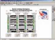
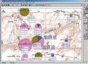
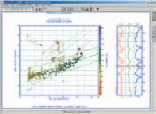
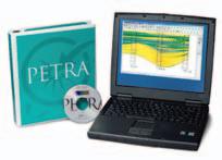
PETRA® delivers the industry’s only easy-to-use and affordable integrated solution for today’s workflows. It provides multi-user access to large projects through geological, petrophysical and engineering analysis tools. The PetraSeis™ option extends PETRA® into 2D/3D seismic interpretation with practical tools such as RasterSeis™ Download a trial version at www.geoplus.com, or call us at 888-738-7265 (Houston: 713-862-9449 / Calgary: 403-264-9523) for more product information.
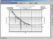
DECLINE CURVES
Compute EUR, RR, etc.
Hyperbolic or exp.
Rate/Time or Cum P/Z
User defined Econ. Limit
User defined Extrap. Time
THE CSPG GRATEFULLY ACKNOWLEDGES ITS CORPORATE MEMBERS:
THE CSPG GRATEFULLY ACKNOWLEDGES ITS CORPORATE MEMBERS:
ABU DHABI OIL CO., LTD. (JAPAN)
ARCHEAN ENERGY LTD.
BAKER ATLAS
BG CANADA EXPLORATION & PRODUCTION, INC.
BP CANADA ENERGY COMPANY
BURLINGTON RESOURCES CANADA LTD.
CALPINE CANADA
CANADIAN FOREST OIL LTD.
CONOCOPHILLIPS CANADA
CORE LABORATORIES CANADA LTD.
DEVON CANADA CORPORATION
DOMINION EXPLORATION CANADA LTD.
DUVERNAY OIL CORP.
ECL CANADA
geoLOGICsystems ltd.
HUNT OIL COMPANY OF CANADA, INC.
HUSKY ENERGY INC.
IHS ENERGY
IMPERIAL OIL RESOURCES LIMITED
LARIO OIL & GAS COMPANY
MJ SYSTEMS
MURPHY OIL COMPANY LTD.
NCE RESOURCES GROUP INC.
NEXEN INC.
NORTHROCK RESOURCES LTD.
PENN WEST PETROLEUM LTD.
PETRO-CANADA OIL AND GAS
PETROCRAFT PRODUCTS LTD.
PRECISION WIRELINE
PRIMEWEST ENERGY INC.
SAMSON CANADA
SHELL CANADA LIMITED
SPROULE ASSOCIATES LIMITED
STARPOINT ENERGY LTD.
SUNCOR ENERGY INC.
TALISMAN ENERGY INC.
TOTAL E&P CANADA LIMITED
CORPORATE MEMBERS AS OF MARCH 24, 2005
TECHNICAL LUNCHEONS
MAY LUNCHEON
Mars in Canada: The NASA Haughton-Mars Project,Devon Island,Nunavut
SPEAKER
Dr.Robert R.Stewart
University of Calgary
11:30 am Tuesday,May 10,2005
TELUS CONVENTION CENTRE CALGARY, ALBERTA
Please note:
The cut-off date for ticket sales is 1:00 pm,Thursday,May 5th.
Ticket price is $28.00 + GST.
The Haughton meteorite impact structure on Devon Island,Nunavut is a fascinating geological site as well as one of the most Mars-like places on Earth.Similar,but not quite as harsh as Mars,the Haughton crater is cold (average temperature –17°C),dry, rocky,and windy.The NASA SETI Institute has led a program of exploration,research, and habitation to the area for the last eight years.The goals of the Haughton-Mars Project (HMP) are to understand the biology and geology of this Mars analogue,in addition to learning how humans can live and work in such an environment.As part of the effort at Haughton,the University of Calgary Applied Geophysics Group has been conducting geophysical surveys,both ground-penetrating radar (GPR) and highresolution seismic,for the last three summers.Objectives of the geophysical work at HMP are to image the permafrost layer (thought to be similar to that on Mars) as well as deeper geologic horizons. Developing near-surface imaging techniques on Earth and applying them on Mars missions should assist in understanding Martian depositional processes, chronologies, and possibly life-related anomalies.
Surveying conditions at HMP can be severe due to the high winds of the polar area (up to 100 km/hr during these field surveys),low summer temperatures (-10°C to +5°C),rain, sleet,and snow – even though this region is characterized as a desert – and significant ultraviolet radiation.Nonetheless,excellent GPR data,acquired using Sensors & Software NOGGIN and PulseEKKO devices,were recorded with 50,100,and 250 MHz
antennae at various sites near the HMP camp. These surveys image depths from about 0.5m to 3m and indicate layering and permafrost events.High-resolution seismic results,using a Geometrics 60-channel system and accompanying geophones,also show the permafrost layer.Shallow excavations,seismic refractions,and GPR reflections at the site all proved useful and indicate that the permafrost layer is at a depth of about 60cm. We also tested geophysical operations in prototype spacesuits and found the suits to be manageable although cumbersome.We expect that subsurface imaging techniques will provide valuable geological information on future robotic as well as manned Mars missions.
BIOGRAPHY
Rob graduated from the University of Toronto with a B.Sc.in physics and mathematics and completed a Ph.D.in geophysics from the Massachusetts Institute of Technology.He has been employed with the Chevron Oil Field Research Company in La Habra,California;Arco Exploration and Production Research Centre in Dallas,Texas;Chevron Geosciences Co.,Calgary; Veritas Software Ltd.,Calgary,and is President of GENNIX Technology Corp.
Since 1987,Rob has been a professor of geophysics at the University of Calgary and held the Chair in Exploration Geophysics from 19871997.He is the director of the CREWES Project, an industry-university consortium studying advanced seismic methods which is supported by 25 energy and geophysical companies around the world.CREWES was honoured with the Society of Exploration Geophysicist’s (Tulsa) Distinguished Achievement Award in 2003.
Rob was President of the Canadian SEG in 199798 and recently received the CSEG’s Honorary Membership Award.In 1999,he completed the SEG’s inaugural Distinguished Educator Program: a 6-month lecture tour - teaching and consulting in 13 countries.He has served as a member of the Canadian Space Agency’s Space Exploration Advisory Board,the California-based Mars Institute,the Association of Professional Engineers,Geologists,and Geophysicists of Alberta (APEGGA) Council,and University Technology International Inc.’s Board of Directors.He has led geophysical expeditions to Central America to apply radar and seismic techniques in archaeological searches and participated in the NASA Haughton Mars Project,exploring in the Canadian High Arctic.
Joint Meeting - Dalhousie University, Halifax, Nova Scotia
May 15–18, 2005
Over the past forty years, exploration in the Canadian Arctic and Atlantic sedimentary basins has resulted in the discovery and delineation of several active petroleum systems, with a number of major oil and gas discoveries under production. The “Petroleum Systems of the Arctic and Atlantic Margins” Symposium sponsored by the CSPG at Halifax 2005, May 15-18, is an ideal venue to bring together those exploring, producing, and researching in the region, to share their interpretations and insights with fellow enthusiasts. Petroleum-related conference field trips showcasing Nova Scotia’s spectacular geology will enhance its value to all participants. Some of the symposia (SM), sessions (GS, SS), courses (SC), and field trips (FT) of interest to CSPG members include:
FT-A2 Salt Tectonics and Sedimentation
FT-A5 Lacustrine Basins (Transtensional and Extensional)
FT-A7 Triassic-Jurassic Faunal and Floral Transition
FT-B1 Accretion of peri-Gondwana terranes
FT-B2 The Joggins section – Lyell’s Galapagos
FT-B6 Macrotidal Environments of the Minas Basin
FT-B7 Deformation Along a Contintental Transform Fault
GS-5 Sedimentology, Paleontology and Micropaleontology
SC-2 Thermochronology – Applications to Geoscience
SC-3 Sequence Stratigraphy for Students (Art Donovan- BP)
SC-4 Geodynamical Modeling (Chris Beaumont, Stockmal, et al)
SM-5c Stratigraphy and Petroleum Systems of Lacustrine Basins
SM-5d Paleozoic Basins in Eastern Canada
SM-5e New Insights for Exploration of Petroleum Systems
SS-5 Transpression and Transtension in Sedimentary Basins
SS-6 Thermochronology – Application to Sedimentary Basins
SS-8 Provenance of Sedimentary Rocks
SS-11 Sediment Instability – Coast to the Slope
SS-14 Big Rivers through Geological Time
SS-15 Coal-age Galapagos
SS-19 Assembling Avalon and peri-Gondawana terranes
SS-20 Ore and Hydrocarbon Systems
SS-21 Upper Paleozoic Basins
For more information contact: Grant Wach, telephone: 902-494-8019, email: grant.wach@dal.ca
REGISTRATION
On-line registration is the preferred method. A downloadable, fax-in registration form will also be available at the conference website. Electronic registration will be available on the website beginning Monday, February 14, 2005. Early registration at reduced costs is available until May 6, 2005. All preconference registration ends at midnight May 6, 2005. Registration after that date will be onsite at the conference. Full registration instructions can be found on the website. The fee structure (in Canadian dollars) includes 15% HST. For more information:
CALL: (902) 424-2523
EMAIL: hfx2005@gov.ns.ca
VISIT: www.halifax2005.ca
MAY LUNCHEON
From deep water exploration to tar sand production: bugs,biodegradation, and the origin of heavy oil
SPEAKER
Steve Larter
Department of Geology and Geophysics University of Calgary
11:30 am Tuesday,May 24,2005
TELUS CONVENTION CENTRE CALGARY, ALBERTA
Please note:
The cut-off date for ticket sales is 1:00 pm,Wednesday,May 19th. Ticket price is $28.00 + GST.
Microbial action has destroyed or altered most of the world’s petroleum resources, producing heavier and more acidic crudes. While this has been known for a long time,
the rates at which this happens,the reactions and organisms involved,and the nature of the alteration process have remained shrouded in mystery.We now know that the major reactions involve microorganisms carrying out hydrocarbon-water reactions,which produce methane as a major end-product as well as heavy oil.We know that the processes take place under anaerobic conditions without the need for free oxygen and we know how fast the process happens.We have even isolated some of the DNA from organisms that carry out the processes.We think that the oil degradation floor at 80°C probably represents the base of life in the crust and it seems the microorganisms in the reservoirs are slowly evolved descendants of those deposited with the reservoir rather than organisms carried down from the surface into the reservoir.It typically takes up to about 10Ma to destroy the n-alkanes in crude oils causing commercial problems in deep waterproduction settings and the Canadian Tar sands could have reached the state they are in around 35Ma or less after reservoiring.The principle control on fluid properties such as viscosity or API gravity is the mixing of fresh oil into actively degrading oil contained in reservoirs.I describe how, using these concepts,fluid properties can be predicted pre-drill using basin modeling approaches.
The production of methane as a common major product during biodegradation of oils in deep reservoirs raises the exciting possibility that if this process could be accelerated,recovery of some of the heavy oil or tar sand bitumens or even residual oils in conventional oilfields,could be recovered as methane on production timescales.
BIOGRAPHY
Steve Larter is currently the Canada Research Chair in Petroleum Geology at the University of Calgary.Steve has held Professor positions at the University of Newcastle,UK,and the University of Oslo in Norway.Prior to coming to the University of Calgary,Steve worked for Unocal in California from 1979 to 1986.Steve received his B.A.in Natural Sciences from the University of Cambridge in 1974.He then received his M.Sc.in Organic Geochemistry and Organic Petrology in 1975 and his Ph.D.in Petroleum Geochemistry in 1978 from the University of Newcastle upon Tyne,UK.Steve’s main research interests include:production of heavy oil,petroleum biodegradation,and petroleum and reservoir geochemistry, migration,and production.
JUNE LUNCHEON
The NEPTUNE project: a cabled ocean observatory in the northeast Pacific –transforming our understanding of Earth/ocean processes
SPEAKER
Chris Barnes
NEPTUNE Canada,University of Victoria 11:30am Tuesday,June 7,2005
TELUS CONVENTION CENTRE CALGARY, ALBERTA
Please note:
The cut-off date for ticket sales is 1:00 pm,Thursday,June 2nd. Ticket price is $28.00 + GST.
NEPTUNE will be an innovative network of over 30 sub-sea observatories linked by 3,300 km of powered,electro-optic cables.These will cover the Juan de Fuca Plate (200,000 sq km) in the northeast Pacific,with shore stations at Port Alberni,BC and Nedonna Beach, OR (www.neptunecanada.ca,www.neptune. washington.edu).Each observatory will host and power many scientific instruments on the surrounding seafloor,in boreholes in the seafloor, and buoyed through the water column.Remotely operated and autonomous vehicles will reside at depth,recharged at observatories and directed from distant labs.Continuous near-real-time multidisciplinary measurement series will extend over 30 years.Major research themes include: structure and seismic behavior of the ocean crust; dynamics of hot and cold fluids and gas hydrates in the upper ocean crust and overlying sediments; ocean/climate change and effects on ocean biota/fisheries at all depths;deep-sea sedimentation, ecosystem dynamics and biodiversity;and engineering and computational systems research. These involve interacting processes,long-term changes,and chaotic,episodic events difficult to study and quantify by traditional means.VENUS, MARS,and NEPTUNE will use most of the same cable and engineering systems with the former two acting as shallow and deep-water test-beds, respectively,for the latter.NEPTUNE is an US/Canada (70/30) partnership with the total facility cost of about $250M.Over $40M has already been funded for design,development and test beds.Funding ($62.4M) for NEPTUNE Canada’s installation was announced in October 2003.VENUS and Stage 1 of NEPTUNE will form a linked coastal/ regional ocean observatory system, and be among the first of many such cabled ocean observatories.Latest installation activities,future planning,opportunities,and implications for the petroleum industry will be discussed.The latter implications include quantitative understanding of
depositional processes on the slope and abyssal plain;gas hydrates;and real-time warning of earthquakes,tsunamis,and major storms that are environmental hazards facing potential hydrocarbon exploration and development in offshore BC.
BIOGRAPHY
Chris Barnes is Project Director for NEPTUNE Canada (2002 to present).For the previous decade,he was Director of both Centre for Earth and Ocean Research and School of Earth and Ocean Sciences at University of Victoria,BC.Earlier appointments were at University of Waterloo (Chair of Earth Sciences),Memorial University (Head of Earth Sciences and established
Centre of Earth Resources Research) and Director General,Sedimentary and Marine Branch,Geological Survey of Canada.Chris has served on many boards/councils,including President of Geological Association of Canada,Canadian Geoscience Council, and Academy of Science of Royal Society of Canada; and Member of Canadian Nuclear Safety Commission,International Ocean Drilling Program,and International Commission on Stratigraphy.His research involves stratigraphy,micropaleontology,paleoceanography,and paleoclimatology,with over 150 publications.Chris received the J.Willis Ambrose and Past Presidents medals of GAC of Canada,Bancroft Award of RSC,and Queen’s Golden Jubilee Medal.He is a Fellow of RSC and a Member of the Order of Canada.
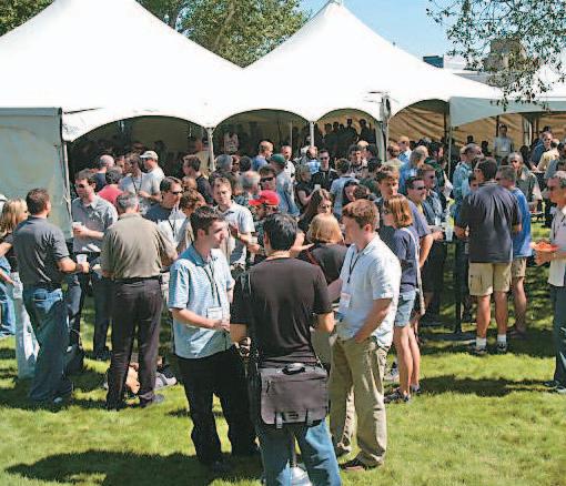
Annual Convention
THE TRADITION LIVES ON!
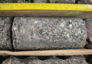
Immediately following the AAPG Annual Convention,the CSPG Core Conference is scheduled for June 23 – 24,keeping the theme Global Round Up:Exploring Energy Systems.
During the two days,25 – 30 core displays will be organized into 3 sub-themes: ✬ Unconventional ✬ Conventional ✬ Frontier/International
It is anticipated that the 2005 CSPG Core Conference will set a precedent in terms of overall attendance because of the fact it immediately follows the AAPG Annual Meeting.
DATE & TIME:
Thursday,June 23 8:00 am – 4:00 pm Friday,June 24 8:00 am – 3:30 pm
LOCATION:
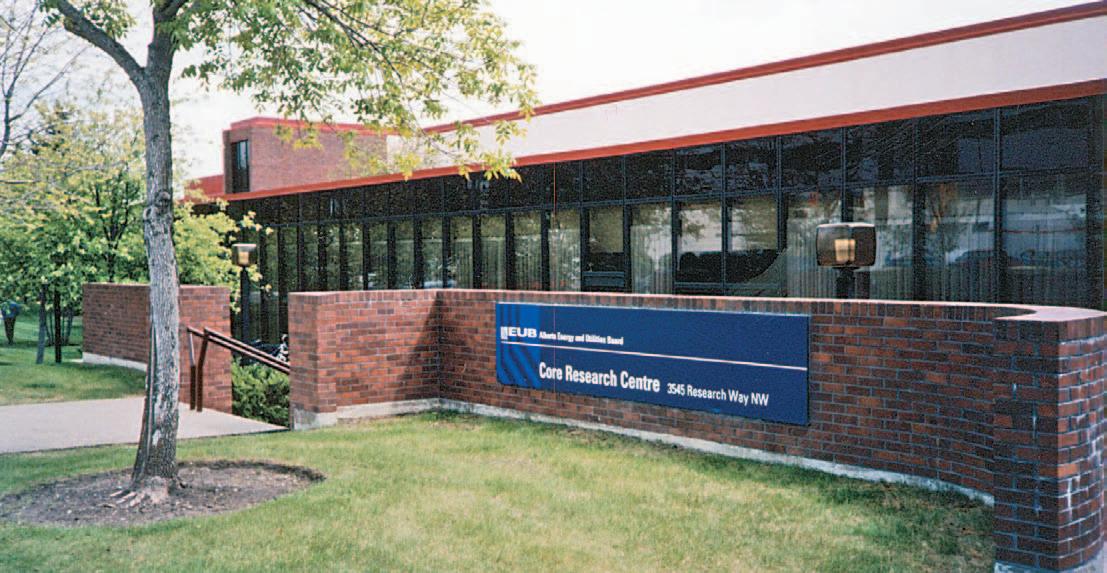
AEUB Core Research Centre (as it has been for the past 35 years)
FEE:
$40 CAD (includes entrance to Core Meltdown) Register online: www.aapg.org/calgary/
JUNE LUNCHEON
Oil and politics:the world oil market in the near term
SPEAKER
Vincent Lauerman
Editor-in-Chief of Geopolitics of Energy and Global Energy Analyst at the Canadian Energy Research Institute
11:30 am Tuesday,June 28,2005
TELUS CONVENTION CENTRE CALGARY, ALBERTA
Please note:
The cut-off date for ticket sales is 1:00 pm,Thursday,June 23rd. Ticket price is $28.00 + GST.
The New World Order is smashed and lying in a heap on the temple floor.This era of globalization,when the New Economy reigned supreme and geopolitics was supposedly dead, came to an end with the events surrounding 9/11.The death of the New World Order has contributed to the birth of the New World Oil Order,characterized by higher prices and greater volatility.
The world oil market,and the people who analyze it,have not yet adjusted to the new geopolitically-charged world we find ourselves.The potential for major supply disruptions are much greater than under a globalized,commercially-driven world,and the potential for cooperation among the major oil consuming countries (as a whole) much less. As a result,the world requires greater supply flexibility (spare production capacity,refiner conversion capacity,commercial oil stocks), not less (the present situation),as well as greater strategic stock coverage.
The War on Terror is going to be a long one, and will continue to threaten production (and investment) in the Middle East for the foreseeable future.Despite positive news out of the region in recent weeks,two major causes of Islamic militancy,Israel-Palestine and Iraq,are unlikely to come to swift,happy conclusions.At the same time,Iran must prove that its nuclear ambitions are peaceful or else become America’s next target in the War on Terror.
We expect WTI to average $45 per barrel in 2005 and $40 per barrel in 2006.The greater risk to our forecast over this period appears to be on the upside,due to the potential for major supply disruptions and a lack of supply flexibility.In addition,the price of WTI should remain above $28 to $30 per barrel,the new mid-cycle (sustainable) price based on our analysis of production from Alberta’s oil sands
(the marginal,incremental barrel of nonOPEC) in the medium term.Barring a major global recession,it will take time to rebuild supply flexibility into the world oil system.
BIOGRAPHY
Vincent holds a B.A.in Political Science and Sociology from the University of Calgary,and a B.A. and M.A.(Economics) from the University of Alberta.He has specialized in world energy issues since 1985,having worked in government, consulting,and as a private speculator.His government service included a stint as special assistant to the Vice-Minister of the Ministry of
International Trade and Industry (MITI) in Japan.
Vincent joined the Canadian Energy Research Institute (CERI) in February 1999.His responsibilities include crude oil price forecasting, geopolitical analysis,and developing global energy scenarios.He is the primary writer of CERI Commodity Report – Crude Oil and Editor-in-Chief of the widely respected journal,Geopolitics of Energy.Vincent was the sole author of CERI’s critically acclaimed study,“Energy Scenarios for the 21st Century.”The media (print,radio,and television) regularly seeks his views on energy and geopolitical issues.
DIVISION TALKS
DIVISION
Fluvial architecture of incised valley deposits:Lance Formation,southwestern Bighorn Basin,Wyoming
SPEAKER
Michael W.Webb
Imperial Oil Resources Ltd.
12:00 Noon
Monday,May 16,2005
Nexen Annex Theatre
+15 Level, North of C-Train Platform 801 - 7th Avenue SW
Calgary, Alberta
Fluvial strata of the latest Cretaceous Lance Formation from near Gooseberry Creek, southwestern Bighorn Basin,Wyoming,are recognized here as incised valley deposits. Thick fluvial sandstone bodies of the basal Lance Formation are exposed as cliffs at the Meeteetse and Gooseberry Creek localities south of Meeteetse,cropping out over 150 kilometres from coeval shoreline deposits to the east.Incised valleys are recognized in the Gooseberry Creek area by combination of regional variation in channel belt amalgamation, changes in sand:shale ratios along strike,and truncation of underlying strata.
Channel belts exposed at Gooseberry Creek are commonly multistory,show pronounced amalgamation with a limited fine-grained component,and are thought to have been deposited near the axes of stacked incised valleys.Channel belts at Gooseberry Creek are 3 to 13 metres thick, and can be traced along outcrop for distances of up to 2 kilometres.They are composed of stacked channel-bar elements of individual channels of low-sinuosity sandy rivers,and are separated by avulsion-related mudstones and siltstones.The unconformity between the basal Lance Formation sandstones and the underlying Meeteetse Formation represents a significant hiatus, and has been documented near this study area as over one million years in duration. Outcrops lateral to Gooseberry Creek along strike exhibit thinner basal Lance Formation sandstone bodies with lower degrees of channel belt amalgamation and lower sand:shale ratios.
The significant distance of the incised valley deposits at Gooseberry Creek from timeequivalent shorelines,while not eliminating the influence of eustacy,suggests a more prominent role for tectonic control of valley formation.Both uplift of the Washakie Range and activity in the Idaho-Wyoming thrust belt
ENVIRONMENTAL GEOLOGY DIVISION
Climate changeanthropogenic or natural
PRESENTER
Members of “Friends of Science” Society
12:00 Noon
Friday,June 3,2005
Aquitaine Building
2nd Floor Conference Room (+15 Level)
540 – 5th Ave SW
Calgary, Alberta
The UN Intergovernmental Panel on Climate Change concluded that increased emissions of anthropogenic CO2 and other greenhouse gases into the atmosphere are responsible for recent climate change.Based on these conclusions the Kyoto Protocol was signed by developed nations,
committing them to reducing greenhouse gas emissions to 1990 levels.
A growing body of scientific evidence contradicts the assumption that increased CO2 concentrations in the atmosphere are responsible for recent warming trends.CO2 is a minor greenhouse gas and its effect on global climate is much less than that of water vapour and solar variations.The conclusion that recent warming is the most abrupt in the last 1,000 years is wrong.A study of history, archeology,and geology illustrate that climate is always changing and the current warming is anything but anomalous.
A video with interviews with scientists who refute the claim that CO2 emissions are the main cause of Global Warming will be screened followed by a discussion with members of the audience.
have previously been shown to influence the deposition of the Lance Formation in the Bighorn Basin.
BIOGRAPHY
Michael Webb received his M.Sc.(Geology) from the University of Alberta for his work on Paleocene mammals from near Drayton Valley, Alberta.He then earned a Ph.D.(Geology) from the University of Wyoming for research in two distinct fields:paleontology of Late Cretaceous mammals and fluvial sedimentology.Since 2001, Michael has resided in Calgary and worked with Imperial Oil Resources Ltd.on various geological projects across Canada.
INFORMATION
Talks are free – don’t forget to bring your lunch! Tim Hortons coffee and donuts will be provided. If you are interested in joining the Sedimentology Division email listing which currently provides luncheon reminders,or if you care to suggest a technical topic or present a talk to the division, please contact Scott Rose at (403) 699-4780 or scott_rose@nexeninc.com.
Visit the sedimentology division website for extended abstracts,forum discussion,photo gallery,upcoming events,and much more at: www.cspgsedimentology.org
BIOGRAPHY
Friends of Science is a Calgary-based non-profit organization with about 100 members.Its members include retired geologists, environmental and atmospheric scientists, entrepreneurs,and engineers.The Society’s mission is to “provide balanced,objective, scientific knowledge to society in such a way that members of the public can make informed decisions on matters that concern them.”Its current effort is directed to the science of Global Climate Change and to promote debate on the causes of Climate Change.
INFORMATION
All lunch talks are free.Please bring your lunch. For information or to present a future talk for the Environment Division contact Andrew Fox at andrew.fox@megenergy.com.
Go to Summer School with AAPG!!
RISK ANALYSIS FOR DEVELOPMENT APPLICATIONS
Dates: June 18-19, 2005
Location: Calgary, Alberta, Canada, with the AAPG Annual Convention
Tuition: $800 (increases to $900 after 5/20/05), includes course notes and refreshments
Instructors: Gary Citron, Jim Gouveia, Rose & Associates, Houston and Calgary, respectively
Who Should Attend
The organization of this course follows the characteristic chain of considerations that attend most Development projects through post appraisal and is thus is designed for engineers, geoscientists and planners involved with drilling, reservoir evaluation, and production management.
CHARACTERIZATION OF TIGHT GAS RESERVOIRS
Date: July 21, 2005
Location: Denver, Colorado
NEW!!
There’s still time to get registered in this Convention course!!
Tuition: $500, AAPG Members; $600, non-members (increases to $600/700 after 6/23/05), includes course notes and refreshments
Instructor: Alan Byrnes, Kansas Geological Survey, Lawrence, KS
Who Should Attend
Geologists, engineers, log analysts, and other professionals with a need to better understand and predict reservoir properties in low-permeability reservoirs and use that information in resource evaluation, reservoir characterization and management.
BASIC WELL LOG ANALYSIS
Date: August 9-12, 2005
Location: Austin, Texas
Perennial Favorite!!
Tuition: $995, AAPG members; $1,095, non-members (increases to $1095/1195 after 7/12/05); includes course notes, refreshments, and a copy of Basic Well Log Analysis by George Asquith and Daniel Krygowski, with Neil Hurley and Steve Henderson
Instructors: George B. Asquith, Texas Tech University, Lubbock, Texas; Daniel A. Krygowski, ChevronTexaco, Houston, Texas
Who Should Attend
Geologists, engineers, geophysicists, and other professionals with a need to understand the responses of common logging measurements to subsurface conditions, and become familiar with basic openhole well log interpretation techniques.
STRUCTURAL DIVISION
Of reefs and rocks: a fractured perspective of the Western Canada Sedimentary Basin, Alberta,Canada
SPEAKER
Darcie H.Greggs
Department of Geology and Geophysics
The University of Calgary
12:00 Noon
Thursday,May 19,2005
Petro-Canada
West Tower, room 17G (17th floor) 150 6th Avenue SW
Calgary, Alberta
Basement structures have been identified in the Buffalo Lake – Red Deer River area of east-central Alberta,through an integration of drill core data,isotope work,high resolution aeromagnetic data,aerial photographs,and reflection seismic data. These structures,which include nearvertical faults bounding fault blocks, synforms,and antiforms,have reactivated through time in response to both far-field and intraplate stresses.A key lithological marker bed has been identified in the cored Devonian units that substantiates the structural interpretation.This unique crenulated unit was originally flat-lying and of broad areal extent.This unit now shows substantial vertical offset between wells (298m),and has been identified in wells as far apart as 7.5km.
Brittle deformation features observed in Frasnian “reefal” rocks (Leduc and Nisku formations) include shear and conjugate fractures,tension gashes,and brecciation. Fractures have frequently undergone solution-enhancement and contribute substantially to reservoir porosity and permeability.Fracture type and density vary with proximity to the large basement structures,as does the occurrence of brecciated intervals that may function as sealing units.Isotope data confirm a hydrothermal contribution to the formation
of secondary cements.Seismites found in cores from the Stettler Formation demonstrate syndepositional seismicity, which seems particularly pronounced at the Frasnian-Famennain boundary.
Comparison of Frasnian subsurface units is made to the Frasnian Cairn Formation biostromes exposed south of Canmore,in the Canadian Rocky Mountains,suggesting that their origin may not always be an organic buildup.This research will enhance reservoir characterization models as well as contribute to the elucidation of the structural history of the Western Canada Sedimentary Basin.
BIOGRAPHY
Darcie Greggs has a B.Sc.(Hons.) in Biology from Queen’s University and a M.Sc.(Geology) from the University of Calgary,where she is currently a doctoral candidate working with the Applied Stratigraphy Research Group.She has over twenty years of experience in the oil and gas and mining industries.Her research interests include both surface and subsurface sedimentological,stratigraphic,and biostratigraphic interpretations within a basement tectonism context;identification of deformation indicators including natural fractures;seismites;utilization of petrographical and isotopic data;and determination and interpretation of surficial and aeromagnetic lineaments and their likely structural significance.Presently expanding research interests include the fields of neotectonism, morphotectonics,and induced seismicity,with occasional forays into planetary tectonics.
INFORMATION
Talks are free;please bring your lunch.Goodies and drinks are provided by HEF Petrophysical Consulting.If you would like to be on the Structural Division e-mail list,or if you’d like to give a talk,please contact Elizabeth Atkinson at (403) 296-3694 or eatkinso@petrocanada.ca.
Application of sedimentology for gas shale reservoir characterization
SPEAKER
Daniel Ross Earth and Oceanic Sciences
University of British Columbia
12:00 Noon
Tuesday,May 17,2005
ConocoPhillips Auditorium
(3rd Floor – west side of building) 401-9th Ave SW (Gulf Canada Square) Calgary, Alberta
Unconventional gas reservoirs are unique petroleum exploration targets due to their gas storage mechanisms and their exceptional volumetric resource potential. Conventional wisdom from gas reservoirs has been adapted to improve the exploration and exploitation of tight gas reservoirs,especially for coalbed methane (CBM) plays of recent years in Western Canada.However there are distinct variabilities of adsorption characteristics between coals and shales suggesting further modification of existing CBM
beliefs is required for gas shale research.
Sorbed gas capacities of moistureequilibrated samples from the Gordondale Member increases with total organic carbon content (TOC) due to the organics highly microporous nature.Adsorption capacities range from 0.05 cc/g to over 2 cc/g in organic-rich zones.Therefore, potential gas shale reservoir ‘sweet spots’ can be identified by mapping organic carbon concentrations,which in turn is a reflection of the evolving sedimentology of individual lithofacies.Changes in sedimentology may lead to changes of organic types which have different adsorption characteristics.Compositional changes subsequently affect the unit’s wireline log response.Furthermore,only through detailed sedimentological analysis can shale compositional changes be identified and explained,such as the presence of biogenous vs.inorganic silica or subtle regressional facies which may provide suitable conduits for gas migration.
However,due to the compositional complexity of organic-rich shales,to state the best gas shale reservoirs are TOC-rich may be an over-simplification.The relationship between TOC and adsorption
capacity is complicated by other compositional parameters:primarily the inorganic component.Moisture reduces methane adsorption capacity where a large proportion of moisture resides with the clay minerals.Methane capacities of moisture-equilibrated samples were lower by up to 30% than those for dry samples. The clay minerals also affect gas diffusivity where only at higher pressures can the microporosity be accessed.
BIOGRAPHY
Daniel Ross graduated with a B.Sc.Honours in Petroleum geology at the University of Aberdeen,Scotland in 2002.Daniel completed his M.Sc.at the University of British Columbia in December 2004 where he researched gas shales,focusing on the Nordegg Member in northeastern British Columbia.He started his Ph.D.in January 2005 where his research concentrates again on gas shale reservoirs.
INFORMATION
All luncheon talks are free – please bring your own lunch.If you would like more information about future EPRD activities,please join our e-mail distribution list by sending a message with the title “EPRD list”to Matthew.Caddel@bp.com or check the CSPG website at www.cspg.org/ emerging_resources.html
GEOMATHEMATICS ANDCOMPUTER APPLICATIONSDIVISION
Visualizing the Upstream Future
SPEAKER
Earl Dodd & Susan Riskey,IBM
12:00 Noon
Wednesday,May 25,2005
ConocoPhillips Auditorium
(3rd Floor – above Plus 15+ level) 401-9th Ave SW (Gulf Canada Square) Calgary, Alberta
When looking at seismic processing and reservoir simulation,the main need is for faster more accurate processing of increasing volumes of seismic data,together with larger more detailed reservoir models, preferably analysed in real time.It is hoped, better analysis and modelling will improve finding success and increase recovery rates. This continues an explosion of requirements for computer power and storage, within the context of fixed or reducing IT investment budgets.
In characterizing this ongoing explosion of innovation,four key themes will continue to add business value for the next decade and beyond:
•Faster - better - cheaper - Moore’s law in action,improved performance at a reduced cost
•Intelligent devices - Computing devices will become smaller,more pervasive,and less intrusive
•Analysis - integration - federationManaging and organizing the exponential proliferation of complex and interconnected data
This presentation will outline some of IBM’s current thinking on future technologies,identifies key themes,and speculates on their impact on the Upstream Industry.
BIOGRAPHY
Earl Dodd lives in Houston and works for IBM’s Systems Technology Group in the Deep
Computing business unit.With over 22 years of High Performance Computing experience, Earl’s multi faceted career has evolved from systems architecture,systems optimization, performance tuning,benchmarking,pre/post sales support,data centre management,team & project leadership of new product development.Earl is currently with the IBM Worldwide team.In Earl’s spare-time,he is completing his MBA.
Susan Roskey lives in Calgary and works for IBM’s Systems Technology Group in the Linux and Grid business unit.Susan works with the Upstream Oil and Gas industry to facilitate Independent Software Vendors port to Linux, optimizing technical applications,and enabling these applications to take advantage of Grid technologies.She works closely with the Deep Computing organization to feed business requirements from the Industry back into IBM research.Her responsibilities include advocating for Linux and Grid with IBM Solutions and Services across industry in Alberta.
2005 CALENDAR OF EVENTS
DATE: May 15-18,2005
EVENT: Halifax 2005 - a Joint Meeting of the Geological Association of Canada,the Mineralogical Association of Canada,the Canadian Society of Petroleum Geologists,and the Canadian Society of Soil Sciences.
INFORMATION: The historic seaport provides a wealth of opportunities to investigate Nova Scotia’s heritage and culture,juxtaposed with all the amenities of a modern urban centre.Extensive seacoast exposures and a diverse geological history provide the backdrop for a rich technical program.The “Building Bridges” theme of the meeting is both symbolic of the harbour bridges that distinguish our Halifax –Dartmouth skyline,and a metaphor for the multidisciplinary program that is designed to bridge the gaps within geoscience,and between geoscience and society.
We look forward to providing you with the opportunity to discover the charms of our beautiful city and renew the ties that bind our geoscience community.For more information please visit www.halifax2005.ca.
DATE: May 30-June 2,2005
EVENT: CSPG Continuing Education Field Trip:Triassic sedimentary framework and sequence stratigraphy.
LOCATION: Williston Lake,British Columbia
INFORMATION: Triassic strata are major hydrocarbon producers in the Western Canada Sedimentary Basin,particularly in British Columbia.Excellent exposure of Triassic strata occurs along the shores of Williston Lake in the Foothills and Front Ranges of the Canadian Rocky Mountains.The Williston Lake field course centers around the sedimentologic and stratigraphic development of the Triassic succession in Western Canada.Excellent outcrop equivalents of all major producing subsurface units (Montney,Doig,Halfway, Charlie Lake,Baldonnel,and Pardonet) are observed and discussed.The Williston Lake trip occurs in a remote part of British Columbia. Participants are thus expected to be in reasonably good physical condition.Participants stay at the Ottertail Lodge near the mouth of the Nabesche River and visit Triassic outcrop exposed along the shores of Williston lake via jet-boat.For more information visit www.cspg.org.
DATE: June 19-22,2005
EVENT: 2005 AAPG Annual Convention – Global Roundup: Exploring Energy Systems
LOCATION: Round Up Centre,Calgary,Alberta
INFORMATION: The American Association of Petroleum Geologists and our host the Canadian Society of Petroleum Geologists,along with the AAPG Canada Region, invite you to the AAPG Annual Convention in Calgary for a “Global Round-Up” where we will “Explore Energy Systems.” Join us June 19-22,2005 to experience Calgary’s world-renowned Western hospitality and benefit from a technical program
that explores energy systems around the globe.For more information please visit http://www.aapg.org/calgary.
DATE: June 23-24,2005
EVENT: CSPG Core Conference
LOCATION: AEUB Core Research Centre,Calgary,Alberta
INFORMATION: One of the cornerstones of the Canadian Society of Petroleum Geologists’ (CSPG) technical activities is the two-day Core Conference held annually in conjunction with the Society’s annual convention –and the tradition will live on during the AAPG Annual Convention! The venue will be (as it has been for the past 35 years) the Alberta Energy and Utilities Board (AEUB) Core Research Centre. During two days of the Core Conference,some 20 to 30 core displays with supporting posters will be organized into 3 sub-themes:Unconventional, Conventional,Frontier/International.For more information,please visit:http://www/cspg.org.
DATE: June 22,2005
EVENT: AAPG (Canada Region) Annual Meeting
LOCATION: Hyatt Regency Hotel,Calgary
INFORMATION: For more information,please contact Dave Scott, dscott@pioneercanada.com
DATE: August 8-11,2005
EVENT: Earth System Processes 2
LOCATION: Calgary,Alberta
INFORMATION: Sponsored by the Geological Society of America and the Geological Association of Canada. Web site:www.geosociety.org/meetings/esp2. Theme Session Proposal submission deadline: September 15,2004.Abstract submission deadline: April 26,2005.Description:International meeting, interdisciplinary focus.Earth’s surface environment is a complex web of feedbacks among the biota, oceans,atmosphere,lithosphere,and cryosphere. ESP 2 will discuss advances made in the last four years toward better understanding the nature of these feedbacks in the modern world,how they have emerged and evolved over the Earth’s history, and how they will respond to human perturbations in the future. For more information,contact:Diane Matt, P.O.Box 9140,Boulder,CO 80301-9140 1-303-357-1014 (phone) 1-303-357-1074 (fax) dmatt@geogociety.org (e-mail).
DATE: November 13-17,2005
EVENT: SETAC North America 26th Annual Meeting
LOCATION: Baltimore,Maryland
INFORMATION: The Society of Environmental Toxicology and Chemistry (SETAC) will hold the SETAC North America 26th Annual Meeting at the Baltimore Convention Center in Baltimore,Maryland, November 13-17,2005.
This year’s theme is “Environmental Science in a Global Society:SETAC’s Role in the Next 25 Years.” More information can be found on the Society’s website:www.setac.org.
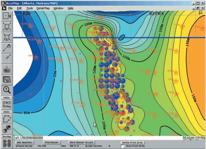
New in AccuMap: US Data modules
Now, US explorationists have data access like they've never experienced before in AccuMap™, IHS Energy's powerful mapping application. Our new US Data modules offer well locations, geology, production and raster log data spanning North Dakota, Montana and Wyoming.
Our Canadian AccuMap and AccuLogs customers are accustomed to transitioning from a 2D spatial understanding to a more comprehensive understanding of their area of interest based on data attributes. But for US subscribers, a desktop tool like AccuMap that provides both surface and subsurface information opens an entirely new and exciting way to work that can lead to new interpretations. As well, creating presentation quality maps and sharing their interpretations with other professionals has never been easier.
“Like our customers, IHS Energy recognizes the basin does not stop at the border. Delivery of our new US data domains will help open up exciting exploration opportunities,” says Alan Mee, Senior Product Manager.
AccuMap's US Data modules offer the same functionality you currently use, including text posting, queries, contouring, production bubble maps, cross section capabilities, and more.
Now, the robust functionality of AccuMap, powered by the best and most current data, powerfully assists the exploration efforts of both Canadian and American explorationists.
At IHS Energy, we're proud to deliver you more current data and the best coverage bundled in meaningful and intuitive software.
JACK PORTERVIGNETTES OF CANADIAN PETROLEUM GEOLOGY
Continued from the April Reservoir
Martin Frobisher’s Third Voyage to his “Frobishers Streytes” to mine for gold
Edward Fenton was undeterred that his anticipated temporary colony,which was to consist of 100 male volunteers,had been cancelled (albeit for justifiable reasons) by Frobisher and his council.Nevertheless, Frobisher sanctioned Fenton’s request that a house be built on Anne Warwick (Kodlunarn) Island.Accordingly,a very small house, comprising an area of 148 square feet,was constructed by the fleet’s masons,who utilized field stones,reinforced with lime cement to form the walls,with the roof covering consisting of wooden slates.The little structure would serve a dual purpose,the results of which could be appraised should Frobisher return on a fourth voyage.Primarily,it was experimental in nature,in order to ascertain its ability to withstand the rigors of an arctic winter.Less importantly,it was to have a public relations purpose,inasmuch as it would serve as a repository for small gifts.If taken by the inquisitive natives these would,hopefully, placate their suspicions of the crewmembers of Frobisher’s fleet.Some of the small trinkets, toys,and personal articles left in the house included:bells,whistles,eyeglasses,miniature figures of men and women – some of whom were on horseback,pipes,knives,combs,lace, and pins.The house also included a stone oven, from which loaves of bread were baked;to be left there,in the hope that they would appeal to the taste of native samplers.
Following the completion of his house,Fenton prepared an adjoining garden in which he planted various grains,as well as peas and corn. The garden,like his house,was an experiment to test the seeds’ ability to germinate and develop after passing through the arctic winter.
Barrels of provisions were buried in expectation that they would be unearthed the following year.For the most part,these consisted of peas and meal (ground cereal grain),which had been intended to contribute to the nourishment of the colonists.Timber, which had been slated to be used in the construction of the colonists’ large house,as well as supplies for its maintenance were likewise buried on Anne Warwick Island.The unloading of these provisions and materials from some of the ships’ holds afforded additional space for the storage of “ore.”
The fate of 10,000 bricks,freighted as ballast in two unnamed vessels of Frobisher’s fleet during
his third voyage,remains a mystery.It would seem unlikely that the bricks,which were to be used as facing for the finishing of the colonist’s house,had been returned to England,at the expense of the equivalent weight of their more valued “ore” (Ibid.,2001,McDermott,James --prol.,p.3).Should the bricks have been stacked on the island,it is conceivable that they were discovered by whalers operating in the area and were subsequently removed to serve as ballast in the whaleboats.
In 1862,Charles Francis Hall,the American arctic explorer who,during his journey to learn the fate of Sir John Franklin and his illfated crew of the Erebus and Terror,visited Anne Warwick Island in the company of local Inuit.The latter’s ancestors had named the island Kodlunarn (White Man’s Island),which name had survived,along with accounts of the white men’s activities,through the medium of their oral history.While there,Hall investigated the vestiges of workings by Frobisher and the men of his fleet,who had left their imprint 285 years earlier.He took as tangible evidence,to reinforce his disclosure,a
significant number of relics.He later presented these to America’s Smithsonian Institution and Britain’s Royal Geographical Society. Unfortunately,these inestimable artifacts, some of which were undoubtedly of European origin,were subsequently lost or misplaced by both institutions (Ibid.,1963,Oleson,Tryggvi J. --- pp.154,155).
Late in August,Frobisher met with his land council,comprising five of his fleet’s captains,to solicit their opinions in pursuing the exploration of the upper reaches of his “Frobishers Streytes” – which passage,he speculated,could access the Southern Sea. Collectively,the council’s members were well aware that by leaving so late in the season,they would be icebound during the winter months. As well,the remaining fleet’s provisions were insufficient for such a protracted period. Frobisher,having fulfilled his mining obligation, recognized the futility of such a venture –despite his unbridled zeal for adventure into the unknown.Consequently,the council’s decision to return instead to England was unanimous.
(Continued on Page 22...)
(...Continued from Page 21)
To the superstitious Elizabethan mariners,the sight of strange natural phenomena often portended the coming of disastrous events.A spectacular display of the aurora borealis,not uncommon in the latitude of Countess of Warwick Sound,was mistakenly attributed by Frobisher and his fleet’s crews to be “many strange Meteors”.This event reinforced their resolve to return home (Ibid.,1971,Morison, Samuel Eliot --- p.542).
A farewell celebration was conducted on Anne Warwick Island by Frobisher’s personnel gathered from the operations in Countess of Warwick Sound.While a bonfire burned at the top of the island’s most prominent rise, soldiers,displaying colorful English banners, marched around it to the blare of trumpets. The ceremony ended with the soldiers firing a fusillade in honour of Anne Warwick,Countess of Warwick.
On August 30th,when preparations were in order for the departure of the fleet from Countess of Warwick Sound,Master Robert Wolfall,the fleet’s chaplain,conducted a service of divine worship for a safe return of the fleet’s personnel to England.The service was held at Winter’s Furnace,located on Newland Island which is situated a short distance to the southwest of Anne Warwick Island.Pastor Wolfall had volunteered to join Frobisher’s expedition on the latter’s third voyage to administer to the spiritual needs of its men.As a dedicated Christian,he had hoped,through his missionary zeal,to convert the native “Infidels” to Christianity.Following Robert Wolfall’s sermon,his congregation was assembled on the mainland where he conducted communion. During his presence with the fleet,he traveled to various vessels and mine sites to provide spiritual guidance to Frobisher’s personnel (Ibid.,McDermott,James --- p.239).
Prior to Frobisher’s fleet departure for England,he distributed to each of his ships’ captains and masters a set of rules pertaining to the conduct of the officers and seamen,as well as the miners,artisans,gentlemen,and soldiers during their homeward journey.Most importantly,for security reason,the ships were to keep company with Frobisher’s flagship, Ayde.He qualified his article by stating:that if any of the fleet’s vessels be separated and fall into the hands of any enemy,that such ship’s maps and charts of Meta Incognita and its mine sites be thrown overboard.The penalty for any theft of the Company of Cathay’s “ore” would be the forfeiture of the culprit’s wages and a fine amounting to threefold the value of the stolen “ore.” Finally,the fleet’s ships were to proceed directly to Dartford,near the Darent River,where their cargos of “ore” would be offloaded and stored,to be later carted to the
(Continued on Page 39...)
These three logs, taken from the same well, demonstrate the power of RECON’S industry leading technology. You have the evidence. The most complete picture from your open hole logs, only from RECON. Call: 51-RECON (517-3266)
Standard 33 samples/meter (1:240)
High-resolution
Ultra high data resolution 133 samples/meter (1:60) Available only from RECON
66 samples/meter (1:120)
The conclusive evidence is in RECON’S ultra-high data resolution open hole logs pinpoint thin beds.
Simplifying Seismic
Chapter 5
Seismic Development in Reef Exploration
Dr.Easton Wren
This is the fifth chapter in a series,which will explain the seismic business in simple terms.Designed specifically for geological personnel in the oil industry,it should provide a forum for information and questions.This installment will focus on seismic developments in reef exploration in the wake of the Leduc discoveries.
INTRODUCTION – LEDUC REVISITED
The discovery of Devonian oil at Leduc in 1947 had significant consequences;not only in terms of its economic impact but also in that it changed the role of seismic forever. The theme of this chapter will be the seismic method as it was used at the time of the Leduc discovery and how it changed in the late 1950s and contributed significantly to subsequent plays at Strachan,Rainbow, Zama,and West Pembina.These seismic discoveries established western Canada geophysicists as the authorities on reef exploration.
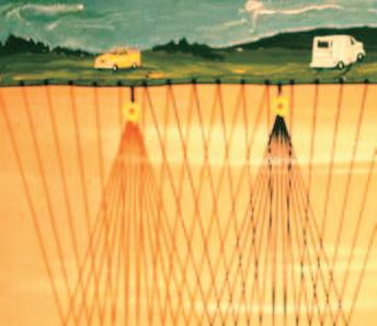
THE BASIC SEISMIC ACQUISITION DESIGN
From the early 1920s,the seismic acquisition system had been relatively simple.A single shothole had a few geophones (channels) on either side,usually symmetrically distributed.In the earliest days,a total of six geophones had been used,
three on either side and in the same line as the shothole.This was called the “splitspread”.With time,the number of geophones (channels) increased and the symmetry was maintained (Figure 5-1).A second shot would be fired at some distance along the line,which would involve picking up and re-laying the geophones in the symmetrical manner described above.Each time the shot was fired the attendant geophones would record the generated information and a “shot record” would be generated.
This gradually evolved into a system of laying the phones initially and firing the shot:then picking up the rear (“tail”) part of the spread and placing it ahead of the front part of the spread and shooting in between the two halves.This distribution of geophones and shotholes along a line is referred to as “in-line” and is the essence of what we now refer to as 2D seismic.The whole approach was labelled “seismic profiling” since the recorded information was assumed to be along a line of traverse.
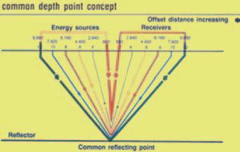
A key element here is that the sampling of the subsurface geology is limited to a series of reflection signals,distributed vertically and horizontally.These individual signals constitute what we now call “single fold” or 100%.This is a statistical reference, suggesting that one signal is recorded at each sample point and there is no statistical re-sampling to establish the validity of the sample value.
In the early 1950s,the industry switched to magnetic tape recording in the field.This
allowed for “playback” whereby some filtering of noise was accomplished. However,the transition to digital recording was still 10 years away.
In 1956,an eminent geophysicist (Harry Mayne) suggested that there was not enough statistical sampling in existing seismic acquisition techniques and demonstrated that re-sampling (redundancy) would provide significant benefit in establishing the signal quality and reducing the major problem in acquisition –shot-generated noise.We should note here that the 1950s are perhaps “memorable” for the widespread use of statistics in numerous scientific disciplines.It was not appropriate for a Masters or Doctoral thesis to ignore statistical analysis of research data.The second point,and the more important one, is that up to this stage geophysics had only been used to identify geological structures (reefs,anticlines,faults etc.),which might contain oil and gas.The idea of interpreting the reservoir attributes (rock type,porosity, fluid content,etc.) had not yet evolved.
Thus beginning in 1956,and continuing till the mid-1990s,the industry made the major progressive switch from single fold (100%) to multi-fold (600% as illustrated in Figure 52),then twelve-fold (1200%),then twentyfour fold (2400%),forty-eight fold (4800%) and so on,culminating in the largest number (in the author’s experience) of four hundred and forty fold (44000%).The arrival of routine 3D seismic in the 1970s compounded this escalation of statistical fold.The growth was so rapid that new generations of geophysicists expected that fold increase was always just around the corner,waiting for new developments in technology,and that it was essential to maintain this growth.
This statistical approach to acquisition was questioned by numerous geophysicists along
Figure 5-1.Seismic shots generating signals that are recorded along a geophone spread.
Figure 5-2.Multifold data.
the way.Granted that the statistical methods helped to attenuate the noise but historically there was no expressed concern about the effect of geology on the signal. With time,it became apparent that this standard multi-fold method of seismic acquisition and data processing resulted in enhanced structural images (both 2D and 3D) but compromised the signal fidelity representing the stratigraphic nature of the geology (these concepts will be discussed in later chapters).
In 1996,Amoco and others suggested that the statistical approach had gone too far. Since then the industry has cut back on the levels of fold and 30-fold (3000%) might be the accepted practice today.
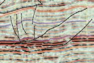
REEF EXPLORATION WITH SEISMIC
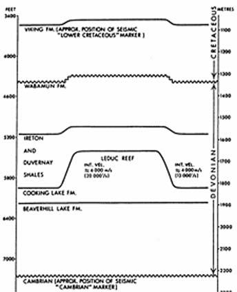
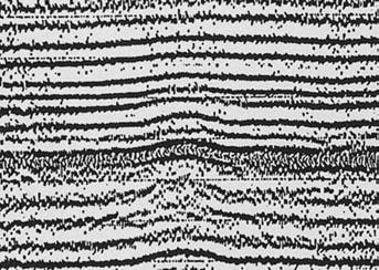
Success in reef exploration was predicated on seismic.Early seismic was certainly useful in identifying the two main characteristics that suggested reef presence.These criteria, “drape” and “velocity pull-up” (Figure 5-3), became the thumbprints for drilling the exploratory well.Success at Leduc was followed by discoveries at Golden Spike (1949),New Norway (1951) as shown in Figure 5-4,and Redwater (1953),all on single fold (100%) pre-digital,pre-magnetic tape recording.
There was a long hiatus before the next key play,once again driven by seismic.In the mid
(Continued on Page 28...)
The most powerful multiuser exploration and production software is breaking thespeed barrier with Linux. GeoFrame® 4 integrated reservoir characterization system has been amplified—improving your workflows,providing the tightest geology and geophysics (G&G) integration, and unsurpassed depth of applications to drive your productivity.
Run the highest quality software on the platform of your choice and experience the turbo-charged energy of GeoFrame on Linux.It handles smoothly, giving optimal performance at high speeds.Preliminary benchmarks show a three to five time increase in speed with Linux. Take advantage of running GeoFrame 4 ina mixed environment, preserve your existing IT investment, and eliminate datamigration.
GeoFrame 4 on Linux is breaking the speed barrier and you can too. Contact your local SIS office or e-mail: sisinfo@slb.com to test drive it for yourself.
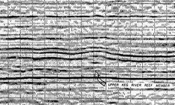
1960s a Mobil geologist,Mike Hriskevich, had a play concept that there might be Keg River pinnacle reefs in the Rainbow Lake area of northwestern Alberta.Seismic data, now 600% and recorded on magnetic tape, identified the reef character and the results were dramatic (Figure 5-5);it was followed in 1966 by a similar approach in Zama Lake and in 1969 at Shekilie.By this time,the industry had converted to digital recording.
It was to be yet another long hiatus before the next important seismic-driven play.In the interim much happened,not only in terms of seismic technology but also in the world of oil at large.OPEC took charge in 1973 and began to escalate the price.With the world nervous at the prospect of US$100 per barrel oil,Alberta and Ottawa had a standoff that crippled industry activity between 1973 and 1975.In 1975 while the oil price continued to escalate,Alberta introduced drilling and seismic incentives to encourage activity and,in 1977,a new reef play emerged at West Pembina.Once again it was driven by seismic,a consequence of the seismic incentive programme successfully implemented by Chevron.For the first time in the basin’s history,Chevron set out to record regional seismic lines extending from
Saskatchewan to British Columbia and one immediate pay-off was the identification of reef anomalies in a part of the basin that was not known to contain Devonian reefs.These reefs turned out to be Nisku (D-2) in age and provided the next exciting play (West Pembina) in Western Canada (Figure 5-6).
EXECUTIVE COMMENT
• Bulletin of Canadian Petroleum GeologyCanadian Society of Petroleum Geologists
• AAPG Bulletin - American Association of Petroleum Geologists
• Environmental Geosciences - American Association of Petroleum Geologists
• Environmental and Engineering Geoscience - Association of Engineering Geologists
• Geochemistry - Exploration,Environment, Analysis - Geological Society of London
• Quarterly Journal of Engineering Geology and Hydrogeology - Geological Society of London
• Vadose Zone - Soil Science Society of America
• Economic Geology - Society of Economic Geologists
• Exploration and Mining GeologyCanadian Institute of Mining,Metallurgy and Petroleum
(...Continued
• Bulletin of the Seismological Society of America - Seismological Society of America
• Leading Edge - Society of Exploration Geophysicists
• Journal of Sedimentary Research - Society for Sedimentary Geology
• Palaios - Society for Sedimentary Geology
• Paleobiology - Paleontological Society
• Journal of Paleontology - Paleontological Society
• Journal of Foraminiferal ResearchCushman Foundation for Foraminiferal Research
• Palynology - American Association of Stratigraphic Palynologists
Texaco Canada established a bonus record at a land sale paying $23,500/acre for a quarter section in the middle of the play fairway.
There will be later discussion on other important plays in the Western Canada Sedimentary Basin.This is just a taste of the seismic contribution to play and prospect generation.
Note:Questions on this and subsequent articles are invited.Please send any question by e-mail to the author at eastonw@ telus.net.A selection of questions with answers will be published regularly.
CORRECTION:
In the March issue of the Reservoir, the article on the Earth Science ring was missing the closing lines. The last paragraph should have read:
From website: http://www.apegga.org/ About/earthr.html
THE EARTH SCIENCE RING: MADE IN ALBERTA
S.Krebes,P.Geoph.
We apologize for any confusion.
Figure 5-4.Seismic character over the New Norway reef.
Figure 5-6.Nisku pinnacle reef at West Pembina (courtesy:Chevron).
Figure 5-5.Keg River pinnacle reef at Rainbow Lake.
from Page 5)
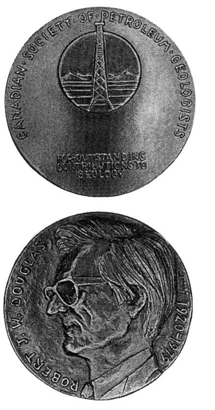
RJW DOUGLAS MEDAL
CALL FOR NOMINATIONS
The RJW Douglas Medal is awarded annually by the Canadian Society of Petroleum Geologists for outstanding scientific contributions to the understanding of sedimentary geology in Canada,commending major contributions to regional tectonics,petroleum and structural geology.
The award is open to all geologists who follow the example of Bob Douglas in contributing to the development of Canadian sedimentary, petroleum, and structural geology.
Nominations for the award of the medal must be endorsed by at least three members of the CSPG. Nominations may be proposed at any time, but to be considered for a particular year, they must be received by the Society before October 1, 2005.
The sponsors of a nominee for the award should supply:
1. A curriculum vitae (outlining the nominee’s career and previous honours or distinctions).
2. A list of publications by the nominee.
3. A summary of the nominee’s achievements in a form suitable for use as a citation for the award.
4 An analysis of the nominee’s achievements, highlighting the contributions for which he or she is being recognized, and relating these to the appropriate publications in the the bibliography.
The last item of information is a key part of the nomination and should convey the magnitude and scope of the nominee’s scientific contributions, with comments of the influence that these contributions have had on others. A “sample submission” may be supplied on request.
Completed nominations should be sent to Graham Davies
CSPG Douglas Medal Committee Chairman c/o GDGC Ltd, Alastair Ross Tech. Centre
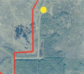
THE MACKENZIE CORRIDOR: ACCESS TO NORTHERN RESOURCES PROJECT (ESS-GSC)
BY DAVID MORROW, EARTH SCIENCES SECTOR (ESS), GEOLOGICAL SURVEY OF
Northern Canada has long been recognized as a frontier for resource exploration beginning with the canoe expedition of Alexander Mackenzie in 1789 down the “Deh Cho” River (Mackenzie River) from Great Slave Lake across the northern Canadian mainland to the great delta (Mackenzie Delta) that now bears his name.Alexander Mackenzie and his backers,the North West Company,were hopeful of a river route to the Pacific Ocean and direct access to the wealth of the Far East.In this regard,the “Deh Cho” River turned out to be a “river of disappointment.” Alexander Mackenzie and the North West Company turned their attention to other routes to the Pacific and the Far East to aid them in their struggle with their great rival,the Hudson’s Bay Company. It was some time before the vast region of northwest Canada began to be appreciated as a potentially resource-rich region that was itself suitable for mineral and petroleum resource exploration,and not simply as part of a region embracing,in the words of a wit of the period,only “arpents de neige.”
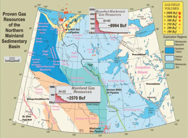
The expeditions of the Geological Survey of Canada across this region in the nineteenth and early twentieth century first brought the resource potential of this region to public notice (e.g.,McConnell,1889).In modern times,two events have focused the imaginations of petroleum explorationists on this region.The discovery in 1920 by Imperial Oil Ltd.,of the large,240 MMbbl oil field at Norman Wells,and later the discovery of multiple oil and gas fields in and near the Mackenzie Delta following an initial oil discovery in 1970 at the Atkinson Point H-25 well.As a conservative estimate,the Beaufort-Mackenzie “Basin” contains at least 9 Tcf of gas (map) and about 1,100 MMbbl of oil.Additional significant gas fields in the Liard Plateau area discovered in the period from 1960 (Pointed Mt.) to 2000 (Liard K-29) have been brought into production and many other gas fields have been discovered in the Colville Hills area and across the southern Great Slave Plain (see map above).
The status of the northern mainland as a resource exploration frontier remains as valid today as in the years following Alexander Mackenzie’s epic journey.There is increasing recognition that energy supply and delivery,nationally and internationally, is of strategic national importance both from the standpoint of the fiscal wellbeing of the national economy and with regard to
the need for an adequate,sustainable,and environmentally acceptable energy supply. No non-renewable energy source is without environmental cost,but natural gas is recognized as the most environmentally acceptable hydrocarbon-based energy source.It has seen increasing use as an energy source for the integrated, continent-wide,North American electric power grid.This has led to the Mackenzie Valley Gas Pipeline proposal,recently submitted by a consortium of energy companies to the National Energy Board of Canada,for a gas pipeline extending southward from Mackenzie Delta and connecting with the existing gas pipeline network south of 60.
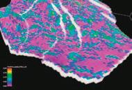
Against this background of societal and national needs,the ESS-GSC Mackenzie Corridor Project was proposed as a project to focus a wide array of geoscientific investigations across the regions that may be affected by pipeline construction and infrastructure development.The centerpiece of this project will be a GIS-enabled geological atlas entitled “Geological Atlas of the Northern Canadian Mainland Sedimentary Basin” that will cover the Mackenzie Corridor and adjacent areas of the Canadian mainland north of 60 as shown on the gas resources map above.The displayed map is GIS-based and linked with a database of proven or discovered gas
resources.The inset charts illustrate the gas resources that are attributable to the Beaufort-Mackenzie Basin versus those now discovered across the rest of the northern mainland.Individual data columns on these charts indicate the resource attributable to each gas field separately.It is clear that, although the Beaufort-Mackenzie Basin contains most of the northern mainland gas, there are other significant gas resources. Many of the less than 100 Bcf fields are only single-well discoveries and may contain significantly more gas than indicated.
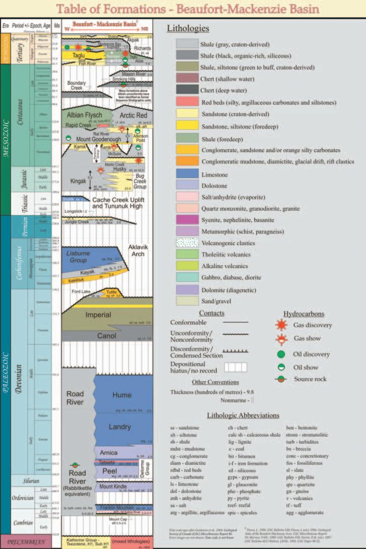
The gas resource map is part of an “Infrastructure and Resources” theme chapter which will include an oil resource map,as well as coal and mineral resource maps as well as pipeline,road and hydro power infrastructure.This chapter will also contain a series of chronostratigraphic tables of formations,such as the BeaufortMackenzie Basin table of formations shown on page 33,that are keyed to the exploration regions shown on the map.The formational nomenclature and formational contact relationships,thicknesses,compositions,and ages in each of these successions have been reviewed for accuracy and consistency.In a related project activity,the downhole formational picks for all wells across the northern mainland have been reviewed and will be made available as part of this chapter, as well as part of the in-house well database
supported by both GSC Calgary and by the CS Lord Northern Geoscience Centre of the NWT.This will provide industry and northern communities with an internally consistent set of “tops” for the northern mainland.Other,now published,“Theme Chapters” include Majorowicz and Morrow (1998) and Park et al.(1998).A series of “Time Slice” chapters will deal in more detail with the stratigraphy,depositional history,and resources of the entire Phanerozoic succession as well as unmetamorphosed Proterozoic strata.Published time slice chapters include Dixon (2004a and b).All atlas chapters will be published initially as GSC Open File CD-R reports.
Ongoing bedrock and surficial mapping (Duk-Rodkin and Couch,2004) south of Norman Wells;permafrost studies,which may be viewed at the NRCan National Permafrost website (http://sts.gsc.nrcan. gc.ca/perma frost/index_e.html) along proposed pipeline routes;and acquisition of new aeromagnetic coverage are important activities that are also part of this project. Visit the ESS-GSC Regional Geophysics Section website (http://gdcinfo.agg.nrcan. gc.ca/index_e.html) and connecting links to view the numerous aeromagnetic surveys open file releases for the Mackenzie Corridor Project that are now available, covering an area extending from the Mackenzie Delta to south of Great Bear Lake.The Mackenzie Corridor Project also includes the wrap-up activities of the former Central Forelands NATMAP project (http://gsc.nrcan.gc.ca/natmap/cf/index_e.php) in northeast British Columbia and the Northwest and Yukon territories at the south end of Mackenzie Corridor.Part 1 of a series of papers dealing with geology and resources of the Central Foreland NATMAP region was published recently in volume 52, number 4 of the Bulletin of Canadian Petroleum Geology.
Suffice it to say that,like the stories of the Russian novelist Fyodor Dostoyevsky, almost too much is contained in the Mackenzie Corridor Project.It is our hope that,as the novels of Dostoyevsky had a profound social impact,this project may have a similarly great impact on the geological understanding of the sedimentary belt of the northern Canadian mainland,as well as providing readily accessible geoscience information for community education and planning and for the reduction of resource exploration risk.
REFERENCES CITED INCLUDE: Dixon,J.,2004a,Jurassic to Lower Cretaceous (Oxfordian to Aptian) of the northern Canadian mainland (a contribution to the Geological Atlas
of the Northern Canadian Mainland Sedimentary Basin),Geological Survey of Canada,Open File 4621 (CD).
Dixon,J.,2004b,Lower Cretaceous (Albian) to Tertiary (a contribution to the Geological Atlas of the Northern Canadian Mainland Sedimentary Basin),Geological Survey of Canada,Open File 4633 (CD).
Duk-Rodkin,A.and Couch,A.,2004,Surficial Geology Fort Norman (96C),N.W.T.,Geological Survey of Canada Open File 4662 (CD).
Majorowicz,J.A.and Morrow,D.W.,1998, Subsurface Temperature and Heat Flow - Yukon
and Northwest Territories,Geological Survey of Canada,Open File 3626,6p.
McConnell,R.G.,1889,Report on an exploration in the Yukon and Mackenzie Basins,northwest Territories,Geological and Natural History Survey of Canada,Annual Report,v.IV,1888-1889,Part D,p.120-134.
Park,J.K.,Buchan,K.L.,Rainbird,R.H.,and Morrow,D.W.,1998,Paleomagnetism of the Yukon and Northwest Territories,Geological Survey of Canada,Open File 3672,19p.
CSPG CORE CONFERENCE JUNE 23-24, 2005
BY GERRY REINSON,CORE CONFERENCE CHAIR
One of the cornerstones of the Canadian Society of Petroleum Geologists’ technical activities is the annual Core Conference. The venue will be at (as it has been for the past 35 years) the Alberta Energy and Utilities Board (AEUB) Core Research Centre,the largest and most functional facility of its kind in the world.
The theme for the CSPG Core Conference will follow that of the AAPG Annual Convention:Exploring Energy Systems.The 22 Core displays will be organized into three sub-themes – unconventional, conventional,and frontier/international.The list of displays separated into these subthemes is as follows:
CONVENTIONAL
Reservoir characteristics,depositional environments and potential oil/gas rates of Devonian and Silurian drilling targets in the Gaspe Basin,Quebec
Hydrothermal dolomite and leached limestone reservoirs:representative core fabrics and facies
Graham R.Davies (Graham Davies Geological Consultants Ltd.),Tom Boreen (Suncor Energy), and Langhorne Smith Jr.(New York State Museum)
Swan Hills Unit build-up and platform:a tale of two reservoirs
Alexis Anastas (Devon Canada) and Judi Dobbin (Devon Canada)
Application of sequence stratigraphy to solve the depositional history of quartz arenite reservoir rocks in the Mississippian carbonate succession of the northern Williston Basin,southeastern Saskatchewan Donald M.Kent (D.M.Kent Consulting Geologist Ltd.)
New perspectives on hydrocarbon potential of Bakken and Torquay formations, southeastern Saskatchewan
L.K Kreis (Saskatchewan Industry and Resources),A.L.Costa (Saskatchewan Industry and Resources),and K.G.Osadetz (Geological Survey of Canada)
The nature and significance of erosion surfaces in the Middle Triassic Doig and Halfway formations,WCSB
Bazlur Rahman (Department of Geology and Geophysics,University of Calgary) and Charles M.Henderson (Department of Geology and Geophysics,University of Calgary)
Reservoir geology of Abbey/Lacadena Milk River equivalent gas field,Saskatchewan
Brad Ford (Husky Energy Inc.),William Gatenby (Husky Energy Inc.),and Michael Staniland (EnCana Corporation)
Comparing Belly River and Sunburst channels with today’s meandering Milk River,southern Alberta
Godfried Wasser (Canadian Natural Resources Ltd.)
FRONTIER/INTERNATIONAL
The Kotaneelee Gas Field,Yukon Territory:an “HTD”-type Liard Basin dolomite play
David W.Morrow (Geological Survey of Canada)
Deltaic deposition in the Upper Cretaceous and Tertiary Beaufort-Mackenzie Basin, northern mainland Canada
J.Dixon (Geological Survey of Canada,Calgary), J.R.Dietrich (Geological Survey of Canada, Calgary),and D.H.McNeil (Geological Survey of Canada,Calgary)
Interpretation of a fractured dolomite core: Margaree F-70,Deep Panuke,Nova Scotia, Canada
Baltimore Canyon Trough Mesozoic carbonate margin cores,offshore USA Atlantic
Leslie S.Eliuk (GeoTours Consulting Inc.) and Bradford E.Prather (Shell International E&P)
CSPG CORE CONFERENCE JUNE 23-24, 2005
Deep-water reservoir facies of the Jurassic Buzzard Field,North Sea,United Kingdom Graham Dore (Nexen Inc.) and Chris Forster (Nexen Inc.)
‘Getting to Know Brenda’:core from a stratigraphic trap in a Paleocene debris-flow deposit,Outer Moray Firth,UK North Sea Rod Christensen (Oilexco Incorporated), Dan Barson (Oilexco Incorporated),and Dean Bilous (Oilexco Incorporated)
Depositional environments and reservoir characterization,Upper Saar,Masila Block 14, Republic of Yemen
The Upper Devonian Duperow Formation of southwestern Saskatchewan:an example of a natural CO2 flood
J.H.Lake (Lake Geological Services Inc.), S.G.Whittaker (Saskatchewan Industry and Resources),and D.M.Kent (D.M.Kent Consulting Geologist Ltd.)
Cabot Petroleum Canada Corporation
Core Labs
ECL Canada
EnCana Corporation
An Early Tertiary meteorite impact structure at Eagle Butte,Alberta
John Visser (EnCana Corporation) and Doug Scott (EnCana Corporation)
Variable formation water resistivity (Rw) and bitumen “flushing” in the Athabasca Oil Sands:effect on bitumen assessment
Michael J.Ranger (Consultant) and Brian Rottenfusser (Redfoot Enterprises)
Cores demonstrating the depositional environments of the McMurray Formation in the northernmost activity of the Athabasca Oil Sands Area:exploring the world’s largest energy system
Errin Kimball (Synenco Energy Inc.), Murray K.Gingras (Department of Earth Sciences,University of Alberta), S.George Pemberton (Department of Earth Sciences,University of Alberta),and Georgia L.Hoffman (Norwest Corporation) Evidence of coal composition and CBM source and reservoir potential in coal cores
Dave Marchioni (Petro-Logic Services) and Judith Potter (JP Petrographics)
Core Labs Specialty Core Analytical Process - TBA
Richard Thom (Core Laboratories)
It is anticipated that the 2005 CSPG Core Conference will set a precedent in terms of overall attendance because of the fact it immediately follows the AAPG Annual Meeting. For those local delegates,we encourage you to attend on Friday June 24th to allow the delegates from out of town to enjoy the Core Conference on Thursday June 23rd.Plus,the much anticipated Core Meltdown will be held
on Friday beginning at 3:30! We are pleased to announce that Baker Atlas is the exclusive sponsor of the Core Meltdown.
Please visit www.cspg.org for registration information.
Sponsored by:
Baker Atlas
Genesis Executive Corporation
Husky Energy Inc.
Penn West Petroleum Ltd.
Petro-Canada Oil & Gas
Sproule Associates Limited
CORE CONFERENCE SPONSORS: CORE MELTDOWN SPONSOR:
Baker Atlas
Please register only one person per form. Name:_____________________________________________________________________________
Email address (necessary to provide email confirmation):____________________________________________
PLEASE MAIL OR FAX THE REGISTRATION FORM AND PAYMENT TO:
If paying by cheque or money order,please make payable to Canadian Society of Petroleum Geologists CSPG Office
160,540 – 5 Ave SW Calgary,Alberta T2P 0M2
FAX:(403) 264-5898
All Core Conference registration must be received in Canadian Funds. All registrations not accompanied by proper payment will be returned to sender/issuer.
Fee: $40 CAD (includes entrance to the Core Meltdown)
For credit card payments:Please provide all the following information Credit Card Number:____________________________________________________________________
It is anticipated that the 2005 CSPG Core Conference will set a precedent in terms of overall attendance,it would be much appreciated if you let us know what days you will be attending. ■ ■ I will be attending on June 23
■ I will be attending on June 24
■ I will be attending on June 23 and June 24
I will be attending the Core Meltdown on June 24
ALBERTA CENTENNIAL CELEBRATION
BY KAREN GREENGRASS,ENTERTAINMENT AND SPOUSE / GUEST ACTIVITIES CHAIR
2005 AAPG Convention
Alberta Centennial Celebration at Heritage Park
A PARTY GOING DOWN IN THE HISTORY BOOKS!
In case you’ve been stuck under a rock somewhere… the CSPG is hosting the 2005 AAPG Convention this June.Included in the week of events is the LARGEST PARTY the CSPG has ever seen! This is the Celebration of Alberta’s Centennial at Heritage Park Historical Village.
All partygoers will be transported from the Round-Up Centre to Heritage Park for 6pm when the evening’s events begin.When the night closes,all delegates will be returned to Stampede Park,where I strongly suggest that everyone makes the choice to use the CTrain,which is conveniently located beside the Round-Up Centre and FREE to use with your delegate badge!
Chances are that a lot of local CSPG / AAPG Members have visited the park at least once in the past,either for a summer weekend visit or a specific holiday event.However,I doubt
that you’ve seen Heritage Park in the fashion that we’re going to show it to you!
Along with the charm of this usually quiet historical village (and it being the perfect place to celebrate Alberta’s birth in 1905…) we are adding exciting,fun-packed,“kick it up a notch” Alberta-style entertainment and activities – just in case our offering of an ALL YOU CAN EAT Western Style Buffet and a HOST BAR isn’t enough to tempt you!?!
A few examples of the evening’s activities include fiddlers,roaming barbershop
quartets,a huge dance floor,“Two-Step” dance lessons,gun-fighting cowboys that will kidnap partygoers who let their guard down… plus a lot of fun surprises throughout the night!
Don’t miss out! Register for the 2005 AAPG Convention and make sure you choose to join us for the Alberta Centennial Celebration at Heritage Park.
See you there (with cowboy boots on)! For more information or to register visit www.aapg.org
Now available for impor t into ACCUMAP and other mapping programs:
BY JOHN HOGG & MARTY HEWITT, AAPG GENERAL CONVENTION CHAIR & VICE-CHAIR
The 2005 Annual Convention has shot out of the gates for delegates registering to attend this much anticipated event! We are well on our way to breaking registration records with attendance projected to be over 5,000 delegates! Several Field Trips and Short Courses are already full;the Entertainment events are proving to be very popular with the Heritage Park night on the Tuesday promising to be the “Party of the Decade”,while the Core Conference being marked as one of the best mix of displays in years!!
Since the CSPG is the HOST SOCIETY of this year’s Convention,all registration fees are in American Dollars and must be submitted through AAPG Headquarters.If you have any questions or concerns about your registration,please contact (888) 9452674 ext.617 or convene2@aapg.org. Lasso the savings – Register by April 15 and $ave!! Remember,as a member of the CSPG,you qualify for the same low rate as AAPG members for registration.
As an added benefit to our members who wish to attend the CSPG Core Conference, only,we will be opening a separate CSPG registration starting May 1st.Please fill out the registration form in this month’s Reservoir and check out www.cspg.org for more information.
newly constructed furnaces at Bignoures Mill on Dartford Creek for refinement.
On August 30th,Frobisher ordered 11 of his fleet’s 13 ships,which were lying off Anne Warwick Island,to proceed to the mouth of Beare’s Sound,where the fleet was to rendezvous.Beare’s Sound is situated 24 miles southeast of Anne Warwick Island and separate Hall’s (Loks Land) Island from the North Foreland Peninsula.The Sussex mine was located on Sussex Island,at the sound’s northwest entrance.The other two ships of the fleet,the Judith and Anne Frances,were to remain behind while repairs to the latter were completed and she was set afloat. After collecting fresh water,the pair rejoined the fleet.
Frobisher left his flagship,at the time of his fleet’s departure to Beare’s Sound and traveled in a sail- and oar-driven pinnace to Sussex mine.Here,he intended to supervise the transfer of the mine’s remaining stockpile of “ore” into the holds of the Gabriel and Michael.It was Frobisher’s design,following the securing of the “ore” to deliver the miners and their equipment to their respective vessels by use of his pinnace.On completion of the operation,he planned to rejoin the Ayde,taking with him the remaining miners from Sussex Island.Frobisher’s arrival back onboard was meant to signal the orderly exodus of his entire fleet from Meta Incognita into the North Atlantic,with his fleet’s vessels laden with an aggregate 1,350 tons of “gold bearing ore.”
Chief pilot,Christopher Hall of the Thomas Allen transferred to the flagship,probably at the behest of Frobisher,just prior to the latter’s departure to Sussex mine.Hall’s responsibility during Frobisher’s absence and which he shared with the Ayde’s Master, Charles Jackman,was to proceed to the entrance of Beare’s Sound,where the ship would rendezvous with the other members of the fleet to await the arrival of Frobisher.
Commencing on August 20th,while Frobisher’s fleet was lying off Anne Warwick Island,he had assigned a number of his ships to proceed to the more distant mines to collect their stockpiles of “ore.” Each mine was abandoned following the removal of its “ore” to the hold of the visiting vessel.Its miners accompanied the vessel’s containment of “ore” on its return to Anne Warwick Island.Consequently,the large number of idle miners,who had formerly mined “ore” at the now deserted mines, were transferred to Sussex Island to assist the miners at their Sussex mine;it being the last of the active mines.A concerted effort, by the fleet’s complement of 150 miners,
was initiated to maximize the production and containment of “ore” by September 1st – that date being the day of the fleet’s departure for England.
Frobisher’s plan for a coordinated departure of his fleet from Beare’s Sound went awry during his evacuation proceedings of miners and equipment from Sussex Island. Intermittent powerful squalls commenced on September 1st,threatening those ships lying off Sussex Island to run aground.The next morning the weather had deteriorated,which prevented the use of the pinnaces in transferring the miners to their awaiting ships.They had feared they were to be abandoned.Later,in the morning,the wind shifted to the northwest,scattering the main body of the fleet from the mouth of Beare’s Sound to the open sea.Frobisher,after overseeing the loading of “ore” in the two barques, Gabriel and Michael as well as the Emanuel (Buss) of Bridgewater, Anne Frances, and Hopewell,was faced with the difficult problem of delivering miners to the aforementioned ships.He had,with respect to the Gabriel and Michael,exceeded their accommodation capacity,resulting in grave overcrowding.His problem was compounded by an insufficient food supply to sustain the barques’ personnel during their return to England.By the end of the day,Frobisher had accomplished the task of removing the miners and their equipment from Sussex Island and allotting them to the vessels anchored offshore.The exception,however, was a remaining group who would accompany him in his pinnace to the mouth of Beare’s Sound where he anticipated that Christopher Hall would be waiting in the flagship to take him and his miners and seamen aboard.
Some of the dispersed vessels that had yet to receive their allotment of miners,took advantage of the favorable winds and sailed for home.However,Christopher Hall remained at the mouth of Beare’s Sound, anxiously awaiting the arrival,by pinnace,of Martin Frobisher and his seamen,and the last of the miners from Sussex mine.He had, during the afternoon of September 2nd,sent out seamen in the Ayde’s pinnaces to search for Frobisher.On returning,they informed Hall that they were told by fellow seamen that Frobisher had boarded the Gabriel, which had left in search of the Ayde . Consequently,he placed at the Ayde’s stern two lighted ships’ lanterns,to serve as a signal to attract the Gabriel or any other vessel of the fleet.Early on the morning of September 3rd,after not having received any fleet members during the night,the conscientious Hall left the mouth of Beare’s Sound for England.He was correct in
assuming that the Gilbert,with Frobisher,had passed the Ayde during the night hours and had not recognized the latter’s posted signal.
The Michael and Gabriel ,both being overburdened beyond a level of safety, departed from the area of Sussex Island in search of the Ayde.The Michael was towing at her stern a pinnace carrying Captain George Best and 25 men,who were unable to have been accommodated on either of the barques.The precarious trio,after leaving Bear’s Sound,was overtaken off Queen Elizabeth Foreland by Captain Edward Fenton’s Judith and Captain George Best’s Anne Frances (Master John Gray commanding) who,on recognizing their plight,offered them relief.Immediately following rescue of the occupants from their pinnace to the Anne Frances,the emptied pinnace disintegrated and disappeared into the sea.Excess men on both the Gabriel and Michael were transferred to the Judith and Anne Frances,with the two barques receiving additional relief in the form of rations to sustain their crews during the homeward journey.
Probably the last vessel to exit Beare’s Sound was the Emanuel (Buss) of Bridgewater.During the fierce squalls of September 1st,she had been driven into the rock-strewn coast on the lee side of Sussex Island.After anchoring amongst the rocks,she managed to extricate herself,under Captain Newton’s guidance and successfully navigated Beare’s Sound’s northeast passage (Lupton Channel) from where she sailed a circuitous route across the northern extension of the Labrador Sea into the North Atlantic.
Captain Gilbert Yorke’s Thomas Allen accompanied the Ayde during the first ten days of their departure from Beare’s Sound. They became separated when the Ayde’s mainyard required repairing,forcing her to remain stationary,while the Thomas Allen continued on her homeward course.On September 2st,the Ayde encountered the Anne Frances and on close contact,George Best shouted to Christopher Hall that Frobisher had fulminated,believing that Hall had abandoned him at Beare’s Sound.
All vessels but one arrived safely at various ports in southern England by October 1st. The exception,however,was the Emanuel (Buss) of Bridgewater.She was shipwrecked on September 26th,after seeking harbor at the village of Smerwick,located on the west coast of Ireland (Ibid.,2001,McDermott, James --- pp.238-244).
Conclusion / aftermath in the June issue of the Reservoir.
WESTERN CANADA’S FIRST SILURIAN PRODUCTION
BY DONNA BURDEN, CANADIAN DISCOVERY LTD.
A 2001 exploratory test drilled by Nexen Canada at Bryant in southeastern Saskatchewan was the first well in western Canada to produce Silurian hydrocarbons (Figure 1).The Nexen Bryant NPW at 12/74-5-7W2 produced oil at a rate of up to 1,370 bopd from the Interlake Formation;a dramatic start for this previously ignored stratigraphic interval.Nexen made the discovery while targeting the Ordovician Red River Formation at a depth of 2,650m with a NFW in the same LSD at 11/7-4-5-7W2. Immediately after that well was drilled,the rig was skidded about 80m west and the second well was drilled to 2,423m in the Silurian.
The initial NFW targeting the Red River at 11/7-4-5-7W2,was drilled during November and December 2001 to the Precambrian. Released in early December,that well was brought on stream at the impressive rate of 689 bopd of oil.However,attention switched immediately to the Interlake,as Nexen licensed the twin well and began drilling in early January 2002.The 12/7-4 was rigreleased on January 20 and was brought onstream by the end of the month at a rate of 979 bopd.Production strengthened with a yield of 1,285 bopd over 16 days in February and rose to approximately 1,370 bopd for 27 days in March,2002.As of February,2005,the well has produced over 120,000 barrels of oil and is still producing about 20 bopd.
Despite being productive south of the border, and having – in part – a similar geological history to the better known Red River Formation,the Interlake has rarely stirred the interest of industry in Saskatchewan.Only a handful of wells,including two attempted completions,had previously hinted at the prospect of oil accumulations in this interval. The first was the Mobil N Redvers 14-19-832W1,drilled in 1957.Multiple DSTs were run from the Mississippian Souris Valley to the Late Ordovician Winnipeg in this well,including five tests across the Interlake.The most successful Interlake test recovered 30.5m of oil-cut mud and 27.5m of mud-cut oil from the uppermost part of the formation,prompting perforations and a production test.Unfortunately,possibly due to formation damage,completion problems,or limited reservoir capacity,this zone performed poorly in the tests and the well was eventually abandoned.A second attempt at producing from the Interlake was made in 1991 at Big Muddy 2-10-1-21W2 by Mark Resources (now Enermark).No DSTs were run in the Interlake,although the zone was perforated along with the Winnipegosis and Red River.All zones were eventually abandoned.
Drill stem tests across the Silurian are rare in Saskatchewan,and tests that recover oil or gas are even less common.The most compelling argument for the prospect of
Interlake hydrocarbons in Canada has been the zone’s performance in North Dakota where total Interlake production is over 58 million barrels of oil.Direct comparisons between the Interlake in North Dakota and Saskatchewan are,arguably,difficult to make. Even though this is the same stratigraphic interval with many similarities in lithological makeup,the interval is thinner on the Canadian side due to lack of deposition and extensive post-Silurian,pre-Devonian erosion.As a result,many of the producing intervals in North Dakota are missing from the section in Saskatchewan.
Composed largely of marine to restricted marine cycles,the Silurian of Saskatchewan holds all the prerequisites to be a significant oil producer.These include:1) potential source rocks in the underlying Red River and possibly in the Winnipeg and Deadwood formations;2) potential reservoir rocks, which include coated-grain,skeletal and lithoclast grainstones / packstones,and algal and coral / stromatoporoid boundstones;and 3) potential seals found in anhydrite beds and tight dolomites,as well as in the overlying Ashern Formation.
Nomenclature describing the Interlake is hugely varied with differences in name, stratigraphic hierarchy,and subdivisions cropping up across different parts of the Williston Basin.In Saskatchewan,the Interlake is considered as a formation,divided into the Taylorton and Cedar Lake subunits in the Upper Interlake,and the Guernsey,Fife Lake,and Strathclair subunits in the Lower Interlake (Figure 2).A log suite from a well in the Bryant field (Figure 3) includes most of the distinctive marker horizons that allow subdivision of the Interlake Formation.
The Interlake comprises a sequence of shallow-water carbonates and minor evaporites deposited in the Williston Basin during the Early to Middle Silurian.Beds of the Lower Interlake are dominated by dolomudstones interbedded with fossiliferous wackestones,and coated grain, lithoclast dolowackestone / packstone / grainstone.Each of the Lower Interlake units exhibit brining and / or shallowing-up carbonate sequences that are capped by laminated mudstones with argillaceous marker beds.The Cedar Lake,which is dominated by dolomudstones,represents the majority of the Upper Interlake.These dolomudstones are interbedded with fossiliferous dolowackestone / packstones, coated grain and / or lithoclast
Figure 1.Location map (data from AccuMap,February,2005).
dolopackstone / grainstones.In addition,the Cedar Lake also contains a number of coral / stromatoporoid boundstone reefs.The Taylorton is the uppermost subunit of the Interlake.It is composed of multiple sequences of dolomudstone,lithoclast dolowackestone,coated grain dolopackstone / grainstone and lithoclast breccia. Depositional thinning and pre-Devonian erosion has limited the extent of the Taylorton throughout much of central Saskatchewan.
Lower Paleozoic oil pools in southeastern Saskatchewan are typically trapped by small closures associated with basement pop-up structures and/or draping over paleotopographic highs due to differential compaction.Many of these structures,which tend to be clustered and aligned,may have been re-activated during the preMiddle Ordovician and pre-Devonian unconformities and possibly again as late as the Mesozoic.A telltale sign of the structures is a missing or anomalously thin Cambrian Deadwood Formation.The Deadwood reflects either topographical relief during deposition and / or uplift and erosion of the sediments following deposition.Based on the distribution of such thin or missing Deadwood,Figure 4 illustrates the distribution of Precambrian highs in southeastern Saskatchewan.If the relationship between the Interlake Formation,basement fault structures,and other Lower Paleozoic oil reservoirs is found to extend beyond the Bryant area,this could be a significant key to locating additional Silurian pools.
INFORMATION
This article is condensed from a more in-depth review by Canadian Discovery Ltd.For the full report or for information on products offered by CDL,please visit www.canadiandiscovery.com or call 269-3644.
ADDITIONAL REFERENCES:
Haidl,F.M.,1995,Hydrocarbon potential of Lower Paleozoic carbonate strata in southeastern Saskatchewan;in Summary of Investigations 1995,Saskatchewan Geological Survey,Sask.Energy and Mines.Miscellaneous Report,95-4,p118-128.
Heck,Thomas J.,LeFever,Richard D.,Fischer, David W.,and LeFever,Julie,Overview of the Petroleum Geology of the North Dakota Williston Basin,http://www.state.nd.us/ndgs/resources/ wbpetroleum_h.htm,accessed 05/03/08.
Kreis,L.K.and Haidl,F.M.,in press,Geology of the Silurian Interlake Formation in Saskatchewan; Sheet 1,Lower Paleozoic Map Series, Saskatchewan Industry and Resources.
Larson,B.W.,Martindale,W.,Nimegeers, A.,and Haidl,F.M.(2003):Saskatchewan’s first Silurian oil producer:Nexen Bryant 7-4T-5-7W2;in Summary of Investigations 2003, Volume 1,Saskatchewan Geological Survey,Sask. Industry Resources,Misc.Rep.2003-4.1,CDROM,Paper A-4,15p.,http://www.ir.gov.sk.ca/ adx/asp/adxGetMedia.asp?DocID=3938,3442, 3440,3385,2936,Documents&MediaID=8667& Filename=nimegeers.pdf,accessed 05/03/08.
Figure 3.Provident Northrock Kingsford 8-14-4-7W2; Abandoned Winnipegosis and Red River Oil;IP:1,574 bopd;Cum:399,145 bbls oil.
Figure 4.Missing or anomalously thin Deadwood Formation in southeastern Saskatchewan,possibly coincident with Precambrian highs (modified from Haidl,1995).
Figure 2.Stratigraphic Chart of the Interlake Formation in Saskatchewan (from Kreis and Haidl,in press).
NEW MEMBER LIST
Student ChapterSimon Fraser University – ESSU
Student Chapter Mount Royal College – Joli Fou Society
Clement J. Benteau NYTIS Exploration Co.
Dane A. Bosman Chemterra International Ltd.
Bryce P. Breunig Baker Atlas
Julie A. Brookson Tango Energ y Inc.
Shelley A. ChristineSamson Canada
Larry C. Darling Enhanced Resources
Angela M. Dasilva
Cameron J. DemmansFairborne Energ y Ltd.
Quentin EnnsCanadian Natural Resources Ltd.
Jeno I. Fabian Husky Energ y Inc.
Jacqueline P. GadesBurlington Resources Canada
E. William JamesPangea Exploration Ltd.
Arzu S. JavadovaAmerada Hess (ACG) Ltd.
Donald R. Martin NYTIS Exploration Co.
Robert J. MillsImperial Oil Resources
Andrew Quarles Pioneer Natural Resources Canada Inc.
Catherine M. ReidQueenís University
Richard B. RidleyEposh Design Ltd.
James. D. Ringheim Occidental Petroleum of Qatar Ltd.
Christopher P. Saxon Chevron Texaco
Ryan R. ShumayParamount Energ y Trust
Dr. Jennifer Ann WadsworthUniversity of Newcastle
Manfred Q. Xu Teknica Overseas Ltd.
2005 WILLIAM C. GUSSOW GEOSCIENCE CONFERENCE
BY MATTHEW CADDEL, 2005 GUSSOW CONFERENCE CHAIR
“Coalbed Methane:Back to the Basics of Coal Geology”,the 2005 CSPG Gussow conference was a resounding success.This year,the Gussow conference was co-hosted with the Canadian Society for Unconventional Gas (CSUG),the Canadian Society for Coal Science and Organic Petrology (CSCOP),and the Society for Organic Petrology (TSOP).
Methane gas from coal is becoming an important resource in the Western Canada Sedimentary Basin.With plays in the Horseshoe Canyon,Gething,and Mannville Formations,many companies are looking to CBM for future resources.Although there are many challenges with any CBM play,it is important to have a clear understanding of the geology,and the variations that may exist,to attain appropriate resource estimates and to make efficient development plans.The theme of the conference,“Back to the Basics of Coal Geology” aimed at bringing the focus to further the understanding of the reservoir.
The conference this year carried a full technical program and also included three keynote speakers.Dale Leckie presented on understanding the sequence stratigraphic correlations with respect to accommodation space in coal seams,using a number of global examples.Thursday evening,Andrew Scott demonstrated CBM exploration techniques and methodologies in basins with limited data. Marc Bustin gave the final keynote address discussing factors influencing reservoir capacities in coal and gas shale.
In addition to the keynote speakers,four technical sessions were held.The first session, chaired by David Marchioni and hosted by the CSPG,was on the Geological Controls of CBM. Session #2 was on the Petrographic and Geochemical Aspects of CBM,hosted by CSCOP and chaired by Marc Bustin.Friday morning’s session,chaired by Peter Warwick and hosted by TSOP,was on the Technical Aspects of CBM from the Lab and Field.Tom Gentzis chaired the CSUG-hosted session on CBM Case Studies finishing off the technical program.A well-attended technical poster session was also held concurrent with the oral sessions.
The event was a tremendous success, attracting over 180 delegates with representation from consulting,industry, government,and academia.Although the primary attendance was Calgary-based, delegates arrived from all over Canada and internationally from the United States, Australia,and France.
Back Row (L to R): Fred Hyland (Organizing Committee),Romeo Flores (Speaker),Mohinudeen Faiz (Speaker),Tom Gentzis (Session Chair/Presenter),Andrew Beaton (Speaker/Organizing Committee),Judith Potter (Speaker/Organizing Committee/Short Course),Gareth Chalmers (Speaker)
Middle Row (L to R): Shane Harrison (Speaker),Dale Leckie (Keynote Speaker),Peter Crosdale (Speaker),Michelle Hawke (Organizing Committee),Allison Gibbs (Organizing Committee)
Front Row (L to R): Prasanta Mukhopadhyay (Speaker),Vern Staciuk (Organizing Committee),Andrew Scott (Keynote Speaker),Matthew Caddel (Conference Chair),Peter Warwick (Session Chair),Greg Bell (Speaker),Sarah Venance (Organizing Committee),Rusty Riese (Speaker)
Missing: Marc Bustin (Keynote/Session Chair/Speaker),Bill MacDougall (Organizing Committee),Dave Marchioni (Session Chair/Short Course),Kim MacLean (Organizing Committee),Sebastian Bell (Speaker),Maria Masterlerz (Speaker),Charles Nelson (Speaker),Charles Barker (Speaker),Steven Tedesco (Speaker),H.Z.von Schoenfeldt (Speaker)
The Canmore Museum and Geoscience Centre opened with a special viewing for the Gussow delegates on Thursday evening.The rich history of coal mining and the picturesque mountainous setting created the ideal locale for the conference this year.
In addition to the conference itself,the CSPG continuing education program debuted a short course “Coal Cores:Examination for Source Rock and Reservoir Properties and CBM Exploration” in the two days preceding the conference.This course was taught by David Marchioni of Petro-Logic Services and Judith Potter of JP Petrographics.It was well received by those who took the class and is recommended for anyone who wants to understand coal petrology from core.
The 2005 Gussow Conference was a huge success due in large part to all of those who helped with the organization.The CSPG would like to acknowledge the following people:
Conference Chair
Matthew CaddelBP Canada Energy Marketing/Promotion
The committee would also like to recognize the sponsors for their support.The Marquee Corporate Sponsors ($5000+) were Natural Resources Canada and Schlumberger.The Keynote Sponsors ($2000+) were AJM Petroleum Consultants,Burlington Resources, EOG Resources,MGV Energy Inc.,Nexen Inc., and Sproule.Visit the website www.cspg.org /gussow_-_cbm.html for updates on post-conference proceedings.
ATLANTIC UNIVERSITIES GEOLOGICAL CONFERENCE
BY LESLEY STOKES, JORDAN STEAD, AND JENNIFER FOWLER, MEMORIAL UNIVERSITY OF NEWFOUNDLAND
HISTORY OF THE AUGC
One of the oldest geological conferences in Canada,the Atlantic Universities Geological Conference (AUGC) is an annual event for undergraduate geosciences students in Atlantic Canada.The conference provides a forum for students from participating Atlantic universities to present and discuss geology research projects,and to attend lectures by guest speakers.During the three-day conference,there are several guided field trips showcasing the local geology.Students who present at the conference are able to compete with their Atlantic Canada colleagues as well as gain vital presentation skills necessary for a career in the Earth Sciences.In addition, students who participate by attending the lectures and presentations are able to learn about different geological subjects through their peers.Field trips to geological sites of interest surrounding the host university contribute to the overall learning experience by presenting the unique geological history of the area firsthand.
Student interaction and participation is the foundation for the success of this conference. Numerous social events are designed to encourage networking among students and faculty from attending universities who have similar research interests and career aspirations.In essence,the conference fosters friendships that will inevitably assist students later in their careers.Each year the AUGC is held at an Atlantic Canada University,chosen by a six-year rotation.The members of the hosting geological society are responsible for the organizing and fundraising that are required for this significant and anticipated event.These geological societies include the Fletcher Geology Club (Acadia University),the Dawson Club (Dalhousie University),the Faribault Geological Society (St.Francis Xavier University),the Bailey Geology Society (University of New Brunswick),the D.Hope-
Simpson Geology Club (St.Mary’s University), and the Alexander Murray Geological Club (Memorial University of Newfoundland).
AUGC 2005
This coming October,the 55th annual AUGC will be hosted,with much anticipation,by the Alexander Murray Geological Club at Memorial University of Newfoundland.A dedicated and enthusiastic organizing committee,composed entirely of geoscience undergraduate students,has already initiated preparations for the conference.The goal of the committee is to provide students with the opportunity to fully experience the geological wonders of the St.John’s area and the vibrant and lively culture of the city.The committee hopes that the combination of the spectacular geology,the resources available at Memorial and the local hospitality will help make AUGC 2005 a wonderful,unforgettable event.
The conference,with an anticipated attendance of 150 students,will start with a friendly meet and greet at the Alexander Murray Geological Club (AMGC) society room.Located on the Memorial University campus,the AMGC undergraduate society was inspired by the late Alexander Murray,a renowned geologist involved with the inauguration of the Geological Survey of Newfoundland.
The second day of the conference will have numerous field trips led by Memorial faculty members.Each trip will be focused on different geoscience topics,including structural geology, paleontology,economic geology,and geophysics.This diversity accounts for the wide spectrum of interest amongst the conference attendees,allowing students to select a trip pertaining to their own interest.Field Trips for AUGC 2005 will include the Avalonian Orogeny at Flat rock,the mineralization and hydrothermal alteration of the eastern Avalon zone,the stratigraphy of Bell Island,and the paleontology of Manuals River.There will also
be a trip focused on the geology within the St. John’s area,and a mini cruise just off the coast to collect geophysical data.
The final day of the conference encompasses student led lecture sessions as well as seminars by guest speakers.The new Inco Innovation Center located on Memorial Campus will be the housing facility for all poster and lecture sessions.Following this,the Johnson Geoscience Centre on historic Signal Hill will be the site for a closing ceremonies banquet,marking the end of the conference.At this event,awards will be presented to competing students for their academic accomplishments.These awards include:the APICS-NSERC Award for the best paper presented at the conference,the Frank Shea Memorial Award for the best paper dealing with Economic Geology,and the Canadian Society of Petroleum Geologists Award for the best presentation of a paper.The Poster Award is presented by the Alexander Murray Geological Club.All student speakers are awarded with a year’s subscription to Atlantic Geology,which is contributed by the Atlantic Geoscience Society.
These prestigious awards,coupled with the spectacular geology of Eastern Newfoundland and with the exceptional culture of the city, will provide a unique experience for all conference participants.In this three-day period,students will have an opportunity to learn new concepts and skills,meet new people,and truly experience why Newfoundland is known as “the Rock”.In the meantime,the AUGC 2005 committee will work towards this objective and in October 2005,provide Atlantic Canadian geoscience students with another,memorable conference.
If you have any questions regarding the conference or what you or your business can do to help make this conference a success,do not hesitate to email augc2005@mun.ca for further information.
A North East view of Signal Hill and residence buildings from the Earth Science Building on Memorial University campus.Photo courtesy of Jennifer Fowler.
The stratigraphy of Bell Island will be one of the main focuses of a field trip held next fall.Greebes Nest at Bell Island,Newfoundland.Photo courtesy of Jennifer Fowler.
WHAT’S GOING ON IN THE CSPG’S EDUCATION COMMITTEE
BY GODFRIED WASSER AND DAVE RUSSUM,CHAIRPERSONS OF
We are in the midst of an exciting year for education at the CSPG.For the last two years we have been working on offering an integrated curriculum for the Membership throughout the year addressing the needs of all experience levels.To attract the best instructors,we have created a package of services for our instructors that takes the ‘bull out of teaching’ and that takes care of safety and liability issues – something required by an increasing number of oil
companies that send their staff to our courses.
Our current emphasis lies on courses with strong local content,something that is not economic to be offered by commercial agencies.Those agencies tend to teach in many other places than just Canada and their content is more generic.For the coming calendar year we are in the process of offering you an exciting array of courses
Empower. Recognize the potential within.
Talisman Energy is making a solid investment in the future success of our community.Two million dollars in Talisman Scholarships will be awarded over the next 10 years to University of Calgary students demonstrating outstanding talent in areas related to the energy sector. These Talisman Scholars will be recognized as thinkers, explorers and achievers who have the potential to move Canada forward into a new era of innovative energy development.
THE CSPG EDUCATION COMMITTEE
starting in May with JP Zonneveld’s Triassic Fieldtrip to Williston Lake.We also are planning to offer a fieldtrip to the Northwest Territories visiting some sensational carbonate reef outcrops, probably around September.In Late September,we’re offering once again our successful Belly River Core workshop & Fieldtrip to the Milk River Valley – which incorporates stratigraphy,sedimentology, and reservoir quality.This fieldtrip is evolving towards the examination of the recent Milk Valley meander system which can be used as an analog to many Middle Belly River reservoirs.
We’re planning courses on CBM, conglomerate deposition,and on fundamentals of clastic sedimentology in the last quarter of 2005.Finally,one more clastic fieldtrip – either to Montana or the Porcupine hills – is in the works.More specifics will follow.
Our curriculum is still under-represented in structural geology,in fractured reservoirs, and in carbonate sedimentology.We badly need qualified instructors in this field,so please join us – teaching through the CSPG is truly more efficient and an investment not only in your own future but also in that of our geological community.With the oil patch becoming increasingly international, only a geological community that is technically strong and with a great work ethic will have a chance to survive.
Talisman Energy and the University of Calgary celebrate their shared commitment to higher education, research,and empowering great minds to effect change. By working together, we can make a difference.
University of Calgary Development Office 2500 University Drive NW Calgary, AB T2N 1N4
p: 403-220-4399 f: 403-282-7688
www.ucalgary.ca/giving
As part of our strategy to offer an integrated education program,the Education Committee will also be looking after convention courses and fieldtrips starting in 2006.To do so we are looking for two individuals with the capacity to coordinate these events.Such persons would not work in a vacuum,they would be part of the Education Committee and they would be supported by the committee’s existing infrastructure.This should be a great improvement over the way these things were handled in the past.If you are interested in spearheading convention short courses or convention fieldtrips in 2006,please,contact Godfried Wasser (403-880-3275) or go to the CSPG website at http://www.cspg.org/ volunteer_positions.html.
Interested in learning more on our courses or in teaching through the CSPG? Visit our website at http://www.cspg.org/education. html.
When it Comes to Wireline –Experience Counts
How does this Baker Atlas team’s experience measure up against NHL Hall of Fame star Lanny McDonald?
NHL Hall of Fame star Lanny McDonald, played professional ice hockey for 16 seasons. This Baker Atlas team has over 280 years of combined experience – an average of 23 years per person. Why the comparison? Experience counts on the ice and in making your wireline operation safe, successful and efficient.
From getting the most out of your data, to having a data acquisition program that best fits your needs, call Baker Atlas in Calgary at 403-537-3400, and find out what our experience can do for you.