■ Celebrate National Engineering & Geoscience Week
■ Celebrate National Engineering & Geoscience Week
■ Simplifying Seismic
■ Simplifying Seismic
■ Annual Awards Report
■ Annual Awards Report
■ 2005 AAPG Convention: Technical Program
■ 2005 AAPG Convention: Technical Program
■ Gussow Conference 2005
■ Gussow Conference 2005
CSPG OFFICE
#160,540 - 5th Avenue SW
Calgary,Alberta,Canada T2P 0M2
Tel:403-264-5610 Fax:403-264-5898
Web:www.cspg.org
Office hours:Monday to Friday,8:30am to 4:00pm
Business Manager:Tim Howard
Email:tim.howard@cspg.org
Office Manager:Deanna Watkins
Email:deanna.watkins@cspg.org
Communications Manager:Jaimè Croft
Email:jaime.croft@cspg.org
Conventions Manager:Lori Humphrey-Clements
Email:lori@cspg.org
Corporate Relations Manager:Kim MacLean
Email:kim.maclean@cspg.org
EDITORS/AUTHORS
Please submit RESERVOIR articles to the CSPG office.Submission deadline is the 23rd day of the month,two months prior to issue date. (e.g.,January 23 for the March issue).
To publish an article,the CSPG requires digital copies of the document.Text should be in Microsoft Word format and illustrations should be in TIFF format at 300 dpi.For additional information on manuscript preparation,refer to the Guidelines for Authors published in the CSPG Bulletin or contact the editor.
COORDINATING EDITOR & OPERATIONS
Jaimè Croft
CSPG
Tel:403-264-5610 Fax:403-264-5898
Email:jaime.croft@cspg.org
TECHNICAL EDITOR
Ben McKenzie
GEOCAN Energy Inc.
Tel:403-261-3851
Email:bjmck@telusplanet.net
ADVERTISING
Kim MacLean
Corporate Relations,CSPG
Tel:403-264-5610,Ext 205
Email:kim.maclean@cspg.org
Advertising inquiries should be directed to Kim MacLean.The deadline to reserve advertising space is the 23rd day of the month, two months prior to issue date.All advertising artwork should be sent directly to Kim MacLean.
The RESERVOIR is published 11 times per year by the Canadian Society of Petroleum Geologists. This includes a combined issue for the months of July/August.
Advertisements,as well as inserts,mailed with the publication are paid advertisements.No endorsement or sponsorship by the Canadian Society of Petroleum Geologists is implied.
The CSPG Rock Shop is an attractive and affordable way to target the CSPG readership. Spaces are sold at business card sizes (3.5” wide by 2” high).To reserve space or for more information,please contact Kim MacLean at 403-264-5610,ext.205.
The contents of this publication may not be reproduced either in part or in full without the consent of the publisher. Design & Layout by Sundog
Our membership is a very responsive bunch! In our annual membership survey,fully 15% of our members took the time to fill in what was a pretty exhaustive on-line questionnaire.This past October,I appealed at the eleventh hour to our membership to answer yet another survey,the anticipated results of which were to make up the core of a CSPG presentation to the annual Canadian Geoscience Council Meeting,held in Ottawa in early November.The submission process was rather archaic,nonetheless 345 of you were kind enough to reply,providing me with an excellent sample and much food for thought.I’d like to share with you some of what I synthesized from that survey data in this executive comment.
I was largely interested in providing answers to three questions:
1) What influences propel young men and women to pursue a degree in geology; 2) what has been,and what is currently,a typical career trajectory following graduation;
3) what are future employment opportunities in our profession likely to be in 5,15,or 20 years?
I confess I had some preconceived ideas as to how some of the answers would tabulate.For instance,one question in the survey asked “what influenced your choice to pursue a major in geology?”.I fully expected to see that the more recent graduates would much more strongly indicate “employment
opportunity” as a primary driver.As the Figure 1 graph indicates,I was very wrong.It appears that regardless of generation,our species tends to be attracted to geology because the subject matter is of inherent interest.Perhaps some of us are born to be geologists!!
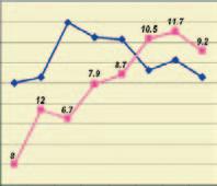
The gender distribution in our profession shows a very strong generational bias. Amongst recent graduates,fully 50% of the workforce is female,but that proportion declines dramatically,when plotted against years of career experience (Figure 2).The reasons for this are probably quite obvious and would include availability of female graduates,biased hiring practices,and career/maternity choices.As we go forward, the retention of a larger proportion of female geologists (more flexible work options?) could ameliorate in part future staffing shortfalls.
Given Alberta’s endowment of hydrocarbon resources,it is no small surprise to find that a significant percentage of society geologists have graduated from either the University of Alberta or University of Calgary,and that this proportion has gradually increased over the last decade to about 40% (Figure 3).A sizeable number of geologists did their undergraduate training outside of Canada.
The proportion of geologists with higher degrees has changed somewhat over the years,but unlike the United States,a B.Sc.is still an acceptable entry qualification for the
Figure 1:Influences leading to a choice of geology major
Figure 2.Distribution of petroleum geologists by years of experience.
Figure
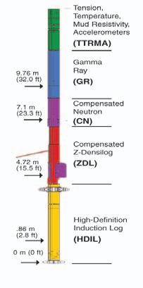
Fed up of drilling 20m of overhole for a logging tool?
Fed up of drilling 20m of overhole for a logging tool?
FOCUS from Baker Atlas requires just 10m of overhole.
The gamma ray measure point on the FOCUS triple combo (array resistivity, density, neutron, gamma ray) is just 9.76m. That saves you drilling time, and maybe even a bit. And logging at 18m per minute saves yet more rig time, by reducing logging times by as much as 40%. Combine that with the best data accuracy in the industry and that’s quite a deal.
FOCUS – efficiency and accuracy, every well, every time.
FOCUS Triple Combo 10.6m (34.5 ft)
THE CSPG GRATEFULLY ACKNOWLEDGES ITS
*CORPORATE MEMBERS:
ABU DHABI OIL CO., LTD. (JAPAN)
ARCHEAN ENERGY LTD.
BAKER ATLAS
BURLINGTON RESOURCES CANADA LTD.
BG CANADA EXPLORATION & PRODUCTION, INC.
BP CANADA ENERGY COMPANY
CALPINE CANADA
CANADIAN FOREST OIL LTD.
CONOCOPHILLIPS CANADA
CORE LABORATORIES CANADA LTD.
DEVON CANADA CORPORATION
DOMINION EXPLORATION CANADA LTD.
DUVERNAY OIL CORP.
ECL CANADA
HUNT OIL COMPANY OF CANADA, INC.
HUSKY ENERGY INC.
IHS ENERGY
IMPERIAL OIL RESOURCES LIMITED
LARIO OIL & GAS COMPANY
MJ SYSTEMS
MURPHY OIL COMPANY LTD.
NCE RESOURCES GROUP INC.
NEXEN INC.
NORTHROCK RESOURCES LTD.
PENN WEST PETROLEUM LTD.
PETRO-CANADA OIL AND GAS
PRECISION WIRELINE
SAMSON CANADA
SHELL CANADA LIMITED
SPROULE ASSOCIATES LIMITED
STARPOINT ENERGY INC.
SUNCOR ENERGY INC.
TALISMAN ENERGY INC.
TOTAL E&P CANADA LIMITED
*CORPORATE MEMBERS AS OF DECEMBER 24, 2004
petroleum geology profession in Canada,and that situation seems unlikely to change any time soon (Figure 4).
We appear to be moving towards an apprenticeship system,and fulltime employment is generally only offered to geologists who have accumulated almost a full year of summer and/or contract petroleum experience (Figure 5).In more recent years,there has been a sharp decline in geoscience work experience (commonly field studies!) outside the petroleum sector (i.e.,mining,government survey, environmental,uranium).
Recent graduates are more likely to end up working for majors,but smaller companies are clearly hiring relatively inexperienced geologists,and this probably reflects a change from past practice (Figure 6).Recent graduates do not tend to be preferentially slotted into certain job areas (e.g., development over exploration geology),and their distribution mirrors the larger population (Figure 7).
Over the course of their career,geologists can expect to see numerous switches in employer (no surprise there!),however I suspect the average number of changes is not out of line with many other industry sectors in the economy (Figure 8).
Looking ahead,what will the demand for geologists be like in a decade or more.This is of course,very difficult to predict,as many variables are in the pot:
• Demand for product
• Profitability (relative commodity price)
• Perception of remaining economic potential for resource
• Global political and economic events
• Workforce demographic
• Hydrocarbon play types
•Technological advancements
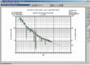
Issues deserving further comment are current demographics (the baby boom bulge),play types that will be pursued in our ever-maturing basin,and new technologies. If we assume that hiring rates remain similar to that seen in the last few years,then as the boomers retire,we conceivably will have an 11% shortfall in ten years and a 34% shortfall in 20 years,amounting to 1,310 jobs (Figure 9).It is however unrealistic to think that industry will not alter its hiring practices to meet real and perceived requirements.
The base of the resource triangle is now being exploited quite intensively by industry. These plays are operationally intensive, requiring either many closely-spaced wells,or in the case of oil sands mining,no wells at all. The reservoir is commonly very widespread, with pervasive hydrocarbon saturation.Such
Figure 4.Education level.
Figure 5.Pre-Permanent petroleum employment exposure to geoscience workforce.
Figure 6.Current employer of recent graduates.
Figure 7.Job focus in petroleum sector.
Figure 8:Changing jobs
TECHNICAL LUNCHEONS
FEBRUARY LUNCHEON
Natural gas storage: western Canada perspective
SPEAKER
Karen James
AUTHORS Garry McCarroll, Shaju Koickel, Heather Joy, Karen James
11:30 am Tuesday,February 8,2005
TELUS CONVENTION CENTRE CALGARY, ALBERTA
Please note:
The cut-off date for ticket sales is 1:00 pm,Thursday,February 3rd. Ticket price is $28.00 + GST.
Natural gas storage capacity in the Western Canada Sedimentary Basin currently exceeds 300 Bcf.Gas is stored by a variety of users for a number of purposes.These include utility companies to meet winter peak demands,pipeline companies for operational balancing,producers to increase sales revenues,end users to reduce costs,and by all types of industry participants to capture opportunities from gas price volatility.
Despite a history of almost 40 years in Alberta,“street awareness” of business and technical criteria for storage development and operations remains low. Why is gas storage an attractive business? Why does an E&P company have clear advantages over Utilities in the storage business? What makes a good storage reservoir? A brief overview of the business drivers behind gas storage will be presented in addition to a detailed discussion of technical elements.
Multi-disciplinary efforts combining conventional geology,geophysics,and reservoir engineering are rigorously applied to define the potential storage container. High quality reservoirs,high deliverability wells,and high commodity prices dictate that operators commit to best practices for inventory control.Understanding and communicating the spatial geometry of the tank is a critical aspect to managing the reservoir.Often,the selected reservoirs
have been depleted by very few wells attesting to the high quality of the original (now depleted) reservoir.Thus,well control may not be as dense as typically encountered in secondary or tertiary oil recovery schemes.With less rock data to characterize internal variations of the reservoir,high quality seismic and mapping of analogy pools are required to extrapolate between wells inside the storage pool and along pool boundaries. Detailed mapping is subject to frequent revision according to reservoir performance and simulation results.
One important difference between conventional exploitation and natural gas storage is cycle time (injection to depletion).The premise that underpins gas storage operations is the ability to deliver large volumes of gas at specific times of peak demand (and attractive commodity pricing).Thus,a pool may be cycled from full to empty within a few months.With such rapid cycling,reservoir assumptions if not
carefully considered will quickly be proven inaccurate with potential costly results.
BIOGRAPHY
EnCana is the largest independent gas storage operator in North America with facilities in Alberta,California,and Oklahoma.Two years ago,EnCana’s Western Canadian project team successfully built the 29 Bcf Countess Storage facility from grassroots.The development took place over one year from concept to in-service date.EnCana’s US New Ventures project team is currently developing its first salt cavern storage facility in Louisiana.
The four authors cited here represent part of a larger dynamic team.Karen James has been project geologist with EnCana’s Gas Storage Team for 11 years.Garry McCarroll has been leading reservoir engineering and operations for Gas Storage for 7 years,Shaju Koickel has been reservoir engineer with the team for 5 years.Heather Joy recently joined the Gas Storage Team as project geophysicist.
CANADA RESEARCH CHAIRS IN
Geophysics - Petroleum Exploration
(Dalhousie University Department of Earth Sciences)
Modeling of Oil and Gas Flow
(Dalhousie University Department of Mathematics and Statistics)
Dalhousie University in Halifax, Nova Scotia invites applications for Canada Research Chairs (Tier II level). The successful applicant will have a PhD and an excellent record in research. Details for each position can be found at:
Mathematical Modelling of Oil and Gas Flow (http://www.mathstat.dal.ca/xpositions.html)
Information on the Canada Research Chairs program is available at www.chairs.gc.ca. The Chairs Program imposes no restrictions on nominees with regard to nationality or country of residence.
Founded in 1818, Dalhousie is a comprehensive teaching and research university, located on Canada’s East Coast. Dalhousie provides the greatest range of undergraduate, graduate and professional courses in Atlantic Canada with over 182 programs – including 87 Master and 39 Doctoral degree programs. Dalhousie is the leading research institution in Atlantic Canada, and its Faculty of Science, with 10 departments, is the primary centre in the region for science education and research.
Enquiries and applications should be directed to the addresses available at the indicated websites. Consideration of applications will commence 1 March 2005 and will continue until outstanding nominees are identified.
Dalhousie
FEBRUARY LUNCHEON
Issues and approaches for integrated hydrocarbon systems analysis in Tertiary deltas - what we have learned:examples from deep water Nigeria
SPEAKER
Lori L.Summa
11:30 am Tuesday,February 22,2005
TELUS CONVENTION CENTRE CALGARY, ALBERTA
Please note:
The cut-off date for ticket sales is 1:00 pm,Thursday,February 17th. Ticket price is $28.00 + GST.
One consequence of the search for new exploration opportunities has been a push into higher-risk areas of known hydrocarbon provinces such as Tertiary deltas.We are testing new plays in deeper water and older strata,and using that experience to push into deeper plays in shallow water.Given this activity,it seems an appropriate time to
HUGH REID’S 2005 COURSES
PRACTICAL DST CHART INTERPRETATION
April 4 - 8
16 WAYS TO IDENTIFY BYPASSED PAY FROM DST DATA
Feb. 7 - 8 April 25 - 26
OIL & GAS FINDING ASPECTS OF HYDRODYNAMICS
May 16 - 19
examine how our paradigms for hydrocarbon systems in Tertiary deltas have shifted through ongoing successes and failures,and use that knowledge to exploit newer opportunities more effectively.This presentation explores elements of what we have learned,via an integrated plate to molecular-scale approach to hydrocarbon systems analysis,with emphasis on alternate scenarios,and on what we might have overlooked.
Evolution in both technologies and approaches to hydrocarbon systems analysis in Tertiary deltas has been driven by a major goal of predicting liquids,though this objective is now changing as natural gas acquires greater economic value.Efforts to accomplish this goal have led to the development of technologies that improve our ability to quantify the volumes and types of hydrocarbons entering and leaving a trap.We use source facies distribution and maturity,structure timing,and the PVT properties of generated hydrocarbons to constrain the inflow of hydrocarbons to a trap.These variables are amenable to quantitative evaluation,assuming a good genetic understanding of the processes
Now available for impor t into ACCUMAP and other mapping programs:
1) New 2004 Version: Glauconitic Channel Trends - Southern and central Alberta, West-central Saskatchewan
2) New: Lloydminster Reservoir Trends - Eastern Alberta
3) Mississippian Subcrops and Devonian Reef Edges - Alberta, NE BC, NWT and Saskatchewan
4) Colony/Sparky Reservoir Trends - East - central Alberta
5) Bluesky-Dunlevy Reservoir Trends - NE BC
6) Halfway-Doig Shoreline Trends - Peace River Arch, NE BC
7) Charlie Lake Siphon, Cecil and North Pine Reservoir Trends - NE BC
All edges are formatted as map features for use in Accumap and ESRI Shape files for other programs. For more information contact: Mike Sherwin 403-263-0594
controlling basin formation and fill,including regional tectonics,climate,and sediment supply,assisted by understanding of molecular clues from rocks and oils.We use structural style,physical properties of seals,regional continuity of major aquifers,and the PVT properties of reservoired hydrocarbons to constrain the outflow of hydrocarbons from a trap.These variables can also be quantified and related to one another using a series of molecular- to regional-scale tools.
But how have the ongoing efforts to quantify hydrocarbon type and distribution modified our overall hydrocarbon systems models for Tertiary deltas? Early models tended to predict a relatively simple hydrocarbon distribution,controlled largely by the presence of higher maturity source rocks in depositional thicks.That simple paradigm has evolved to a model in which complex migration histories and trapping mechanisms are now thought to be a major control on hydrocarbon type and distribution.In addition,timing of hydrocarbon charge relative to trap development has always been recognized as an important factor in predicting hydrocarbon type and quality,but the tools developed over the past several years enable us to quantify those relationships and better predict hydrocarbon distribution. Finally,our understanding of how fluid pressures and seal properties constrain the type and distribution of hydrocarbons has also evolved significantly.This presentation illustrates the evolution of these tools and approaches,with examples of evolving hydrocarbon systems models from deep water Nigeria,and potential application to other deltaic systems.
BIOGRAPHY
• Lori received her B.Sc.from University of Rochester,New York in 1979 and her Ph.D.from University of California,Davis in 1985.
• Lori has worked with ExxonMobil Upstream Research Company in Houston,Texas since 1985.
• Her research includes Integrated hydrocarbon systems analysis,fluid flow,basin modeling,fluid inclusions,and clastic diagenesis.Since 1990,she has been the research scientist and team lead for the hydrocarbon migration and basin modeling technical team.Currently she is team lead on a research project targeting new exploration opportunities through integration of technologies related to basin formation,fill,and evolution.
• Lori is an AAPG member and is an author with numerous publications and presentations to her credit.
CONTOURING
Faulted contours
Isopachs
Volumetrics
Grid operations
New flexing options
CROSS SECTIONS
Digital and/or Rastor
Geocolumn shading
Multiple rasters/well
Stratigraphic/Structural
Shade between crossover
Dipmeter data
MAPPING OPTIONS
Bubble maps
Production charts
Log curves
Posted data
Highlighted Symbols
CROSS PLOTS
Log crossplots
“Z” crossplots
Lithologies to facies
Pickett plots
Regression curves
User defined overlays
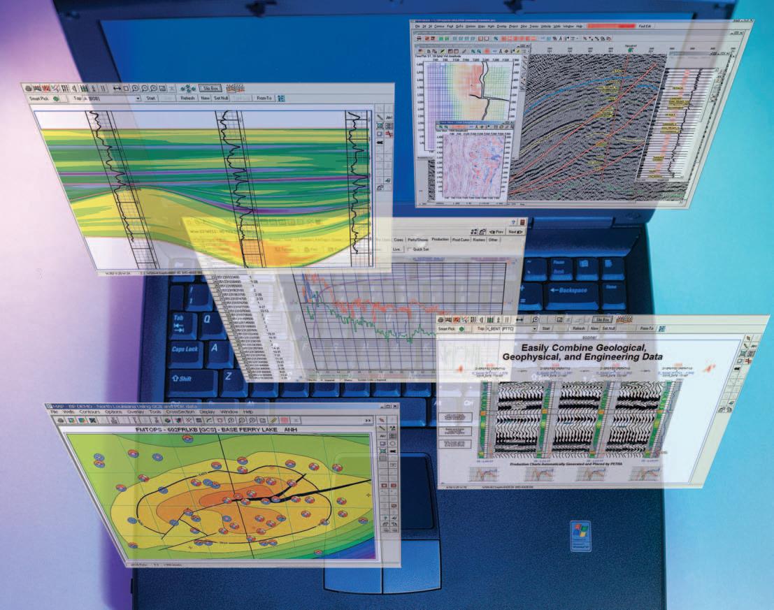
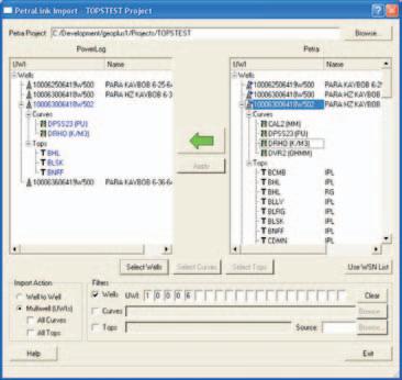
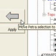
PETRA® delivers the industry’s only easy-to-use and affordable integrated solution for today’s workflows. It provides multi-user access to large projects through geological, petrophysical and engineering analysis tools. The PetraSeis™ option extends PETRA® into 2D/3D seismic interpretation with practical tools such as RasterSeis™ Download a trial version at www.geoplus.com, or callus at 888-738-7265 (in Houston, call 713-862-9449) for more product information.
DECLINE CURVES
Compute EUR, RR, etc.
Hyperbolic or exp.
Rate/Time or Cum P/Z
User defined Econ. Limit
User defined Extrap. Time
TECHNICAL LUNCHEONS
MARCH LUNCHEON
Making sense of turbidite reservoirs:a multi-basin perspective on what drives architecture and rock properties
SPEAKER
David C.Jennette Bureau of Economic Geology
The University of Texas at Austin Research Project Manager
11:30 am Tuesday,March 15,2005
TELUS CONVENTION CENTRE CALGARY, ALBERTA
Please note:
The cut-off date for ticket sales is 1:00 pm,Thursday,March 9th. Tickets are $28.00 + GST.
Our knowledge of turbidite reservoirs has advanced rapidly over the past 15 years, owing largely to the petroleum industry’s acquisition of ever larger and higher frequency 3-D marine seismic surveys. These surveys provide a stunning portfolio of high-resolution snapshots of ancient and modern submarine landscapes and illustrate the intricate details of their accompanying turbidite systems.As 3-D volumes are stitched together and timestratigraphy across large parts of continental slopes established,subsurface workers can reconstruct characteristics of the ancient shelf,shelf edge,slope,and basin floor environments and deduce the suite of processes and controls that led to the development of the spectrum of turbidite reservoirs.Understanding these basic controls improves our ability to generate models that better predict the broad range of attributes required to ensure commerciality in costly offshore operating environments and/or settings where resolution of the objective is compromised by salt or deep burial.
Subsurface systems like those encountered in the Paleogene of the North Sea and the Tertiary of the Gulf of Mexico,offshore West Africa,and offshore Egypt,together with the outcropping systems of the Permian of West Texas and the Carboniferous Claire Group of western Ireland,provide comparative data sets from which to evaluate the principal mechanisms that establish turbidite reservoirs.We
observe contrasting styles of architecture (channel-dominated to sheet-dominated), pattern (straight versus highly sinuous, dendritic versus lobate),sand percent,bed thickness,and grain size and sorting.These characteristics can be tied to (1) the sediment delivery system that,in conveyer belt fashion,controls the composition and volume of sediment available to the shelf edge,(2) triggering mechanisms at the shelf edge that control the volume,feed rate, and concentration of the flows,and (3) sea floor gradients that influence the acceleration,steadiness,or deceleration of flows.Within any one system,much of the reservoir architecture we observe can be tied back to the sand:mud ratio of flows and to sea floor gradient.A fourth factor influencing final architectural character, particularly on the upper slope,is modification by slumping or headwardly migrating erosional nickpoints.
Amid all of the volume-based characterization tools,classical seismic sequence stratigraphy remains one of the stratigrapher’s most important characterization tools.Whether applied to outcrops or subsurface data sets,it provides a method to establish reservoir properties of genetically related deposits. Increasing seismic resolution allows subsurface stratigraphers to identify a highly detailed array of reservoir building blocks and systems tracts that lead to better prediction of individual fluid flow units.Sequence stratigraphy also helps identify changes in reservoir characteristics that occurred over a longer unit of geologic time.Such evolutionary changes record systematic variations in the sediment delivery system,shelf edge character that may be driven by eustasy, climate,or accommodation space.
BIOGRAPHY
David C.Jennette received his B.S.,Geology,in 1982 from Allegheny College in Meadville, Pennsylvania.He then received his M.S., Geology,in 1986 from the University of Cincinnati in Cincinnati,Ohio.
David is currently a Research Project Manager at the Bureau of Economic Geology at the University of Texas at Austin;Prior to this David worked with Exxon as a Research Geologist as well as an Exploration Geologist.
David’s professional interests lie in:Reservoir prediction,reservoir characterization,and
sequence stratigraphy of clastic depositional systems;his current focus is on multidisciplinary analysis of turbidite systems.
David has authored and co-authored numerous proprietary reports,published papers,and abstracts and is a member of the American Association of Petroleum Geologists and the Society for Sedimentary Geology.
MARCH LUNCHEON
Regional underpressure and gas-saturation in the Upper Cretaceous and Tertiary of Central Alberta
SPEAKER
Jim Letourneau
Big Picture Geoscience Inc.
11:30 am Thursday,March 24,2005
TELUS CONVENTION CENTRE CALGARY, ALBERTA
Please note:
The cut-off date for ticket sales is 1:00 pm,Monday,March 21st. Tickets are $28.00 + GST.
The Upper Cretaceous and Tertiary sandstones of Central Alberta (Paskapoo, Scollard,Edmonton,Horseshoe Canyon,and Bearpaw) form a major shallow,low-pressure gas resource.Potential sources of this gas are from associated coal seams and bacterial activity at the water/gas contact.These zones
were initially bypassed due to formation damage and low gas prices.
A hydrostatic water gradient is up to 350% overbalanced in some of these formations.A detailed examination of over 800 pressure tests confirmed that the Scollard member and Edmonton Group are pervasively gassaturated.Formation pressures decrease with proximity to formation outcrop along the Red Deer River.Conventional hydraulic head calculations using these data result in an east-west hydraulic gradient.
The extreme underpressures in these zones have been attributed to pore volume expansion associated with erosional unloading.This paper proposes an alternate hypothesis.Gas pressure gradients show a predominantly west to east gradient.The lowest measured formation pressures (<200 kPa) were usually found within 20 km of the formation outcrop.It appears that the bulk of the gas is migrating up-dip in response to the regional gas pressure gradient.Post-Tertiary methane desorption has decreased coal gas content.Lateral migration of gas towards
outcrop along the Red Deer River Valley is proposed as a mechanism to create underpressures in the Upper Cretaceous and Tertiary sandstones in Central Alberta.
BIOGRAPHY
Jim Letourneau,B.Sc.,P.Geol.is the Principal of Big Picture Geoscience Inc.and the Publisher of the Big Picture Speculator investment newsletter and weblog.His current interests are applying petroleum hydrogeology and geochemistry to characterize basin-centered gas systems.
Jim was a co-chair of the 1997 AAPG Hedberg Conference on Applied Petroleum Hydrogeology in Exploration and he has presented numerous research papers on the geochemistry and migration of natural gas.He recently served as an expert witness on unconventional gas accumulations for a National Energy Board hearing.
Jim received the CSPG Tracks Award in 1996 and the APEGGA R.M.Hardy Graduate Scholarship in 1999.He is a member of the CSPG,AAPG, APEGGA,CSUG,CSTA,and Toastmasters International.
ConocoPhillips
is pleased to announce the recipients of the ConocoPhillips Glen Ruby Memorial Scholarships in Geoscience for 2004.
Kimberly Robinson
Melissa Peterson
Marc Boulet
ConocoPhillips would like to wish all applicants the best of luck in their studies and future endeavors.
DIVISION TALKS
HYDROGEOLOGY DIVISION
A look at groundwater pumping from the outside-in: using transition curves to investigate areal impacts of groundwater resource development
SPEAKER
Kevin Parks
Alberta Geological Survey
12:00 Noon
Thursday,February 17,2005
Encana Amphitheatre, 2nd Floor
East end of the Calgary Tower Complex 1st Street and 9th Avenue SW Calgary, Alberta
The effects of pumping wells on aquifers and drainage basins are easily captured in graphs
Early Bird Registration closes January 31 Registration closes March 4
of drawdown-versus-time or on drawdown maps.Transition curves,which show the relative contributions of pumped waterby source over time,are less commonly used. However they can show additional information about the impacts of pumping on the hydrological system.They can be used to assess the incremental impact of resource projects on local groundwater and surface water resources.Examples of their potential use from ongoing AGS work in the Cold Lake-Beaver River Drainage Basin will be discussed.
INFORMATION
The luncheon talks are free and open to the public.Please bring your lunch.Refreshments are provided.For further information,or to present a talk,please contact Stephen Grasby at (403) 292-7111or sgrasby@gsc.nrcan.gc.ca.
SEDIMENTARY DIVISION
The porous dolomudstone facies of the Pekisko Formation (Lower Carboniferous) Alberta,Canada
SPEAKER
John Hopkins University of Calgary
12:00 Noon
Monday,February 7,2005
Nexen Annex Theatre
+15 Level, North of C-Train Platform (Nexen Annex Building) 801 – 7th Avenue SE Calgary, Alberta
A geological curiosity is the tendency for carbonate mudstones in some formations to become preferentially dolomitized within limestone successions.Such is the case in the Pekisko Formation where dolomudstone bodies form small but important oil and gas reservoirs.
Pekisko Formation dolomudstones are intercalated with and overlie grainstones. The host sediment of the dolomudstone, interpreted from relict textures preserved in chert nodules,was a microwackestone comprised mostly of silt- and clay-size particles deposited in subtidal inter-shoal and back-shoal lagoonal environments of the inner ramp.The dolomudstone reservoir facies is comprised of dolomudstone and subordinate dolowackestone and dolograinstone that grade laterally into calcareous dolomudstone. Dolomudstone reservoir bodies are irregular in shape,up to about eight metres thick,and are laterally continuous over several kilometres.
Dolomitization is interpreted to have been early and selective to the dolomudstone facies because the dolomudstone host retained permeability or was reactive during early burial.In contrast,grainstones and lime-mudstones were cemented or their porosity was destroyed by compaction. Dolomitizing fluids were most likely derived from overlying formations and made their way downwards into the dolomudstone through spatially separated conduits. Subsequently,the Pekisko Formation was exposed and sculptured at several Late Carboniferous to Early Cretaceous unconformities.During these times, sandstones and shales were deposited in solution cavities developed within the dolomudstones.Leaching of calcite from the dolomudstones increased porosity of the dolomudstone reservoir facies.
BIOGRAPHY
John Hopkins is an Associate Professor at the University of Calgary.His research interests include sedimentology and petroleum geology of both carbonate and siliciclastic sedimentary rocks.Current research is centered on paleohydrology and paleokarst with excursions into modern karst.
INFORMATION
Talks are free – don’t forget to bring your lunch! Coffee and donuts will be provided.If you are interested in joining the Sedimentology Division e-mail listing which currently provides luncheon reminders,or if you care to suggest a technical topic or present a talk to the division, please contact Scott Rose at (403) 699-4780 or scott_rose@nexeninc.com.
STRUCTURAL DIVISION
Geological velocities for seismic depth processing
SPEAKER
Rachel T.Newrick
Nexen Canada Ltd.
12:00 Noon
Thursday,February 17,2005
Petro-Canada
West Tower Room 17 D
150 6th Avenue S.W.
Calgary, Alberta
“The interpretation of observed elastic wave velocities in the rocks of the earth’s crust is our principle basis for inferring its structure at inaccessible depths.” Ide,1936.
Ide’s statement is as true today as it was back in 1936.He goes on to talk about the practical nature of geophysics and how the observed time differences are more important than the actual velocities in
Advancing
different rocks.This is no longer true.With the advent of depth processing,there is a paradigm shift back to requiring the actual velocities of elastic waves travelling through rock.
In recent years the focus of seismic processing has moved from time migration to depth migration.Time migration is commonly preferred for its simplicity and utilizes imaging velocities to construct an image of the sub-surface.In areas of complex deformation,characterized by laterally varying velocity fields,depth migration is required.Depth processing uses estimated interval velocities which can prove challenging,but will provide additional information regarding the subsurface.
Time migration is less sensitive than depth migration to variations in the velocity model which may result in interpretation pitfalls in areas of deformed bedding.Structures in areas with lateral velocity variations may be distorted.This potential pitfall is often
the process of reservoir management
avoided by the use of a precise velocity model to convert time sections to depth sections although this will not resolve the lateral mis-positioning of structures by time migration.
Depth migration is required to correctly position reflectors in complex structures which typically have steeply dipping beds, closely spaced folds and faults,and lateral velocity changes.Ultimately,to obtain accurate imaging the correct velocity model is required.Anisotropy further confounds the issue and can lead to errors in the final image and must,therefore,also be considered in the velocity model.
Presently,the velocity model used in depth imaging is refined by selecting velocities that best flatten events on common image gathers and create the most coherent depth migrated section.However,how this velocity model relates to the actual geological model is often not considered.By understanding the relationship between the seismic velocity model and geology,we should be able to improve the velocity model,and subsequently improve the seismic depth migration.
BIOGRAPHY
Rachel Newrick is a geoscientist with Nexen Canada Ltd.and is currently working with the Canadian New Growth Team.
Rachel earned a B.Sc.in geology (1992) and a B.Sc (Hons.) with first class honours in geophysics (1993) from Victoria University of Wellington,New Zealand,and Ph.D.in exploration geophysics from the University of Calgary (2004).During her studies,Rachel worked with BHP (Melbourne,Aust.),Occidental (Houston),Veritas (Calgary),and ExxonMobil (Houston).
Rachel recently co-authored an SEG geophysical monograph “Fundamentals of Geophysical Interpretation”with Dr.Larry Lines of the University of Calgary.
PALAEONTOLOGY DIVISION
Mega-mining for ancient marine reptiles:plesiosaurs and ichthyosaurs from the Athabasca Oil Sands Area of northeastern Alberta
SPEAKER
Patrick Druckenmiller University of Calgary
7:30 PM Friday,February 25,2005
Mount Royal College Room B108
4825 Richard Road SW Calgary, Alberta
Between 1991 and 2000,nine specimens of marine reptiles have been serendipitously discovered near Ft.McMurray,Alberta in an enormous,open pit oil sands mine operated by Syncrude Canada,Ltd.The new finds, including seven plesiosaurs and two ichthyosaurs,were recovered from the Early Cretaceous (approximately 110 Ma) Wabiskaw Member of the Clearwater Formation,which is removed as overburden at the mine.The Wabiskaw Member was deposited during the first major marine transgression of the Boreal Sea southward into the Western Interior Basin of North America during the Albian.
Three of the seven plesiosaurs are longnecked forms,two are short-necked,and two are fragmentary and taxonomically indeterminate.One of the short-necked plesiosaurs is remarkably well-preserved and constitutes one of the most complete plesiosaurs from North America.Both ichthyosaurs are referable to the only genus of Cretaceous ichthyosaur,Platypterygius.
The specimens are significant in many regards.Several of the plesiosaur specimens represent new taxa,helping to bridge a 40 million year gap between the much greater diversity of plesiosaurs known from the Late Jurassic of Eurasia and the Late Cretaceous of North America.Collectively,the specimens represent the oldest Cretaceous plesiosaur and ichthyosaur remains known from the Western Interior Basin,prior to the establishment of the Western Interior Seaway.
BIOGRAPHY
Patrick is currently working towards the completion of his Ph.D.in the Department of Biological Sicences at University of Calgary.
INFORMATION
This event is jointly presented by the Alberta Palaeontological Society,Mount Royal College and the CSPG Palaeontology Division.For
information or to present a talk in the future please contact CSPG Paleo Divison Chair Philip Benham at 403-691-3343 or programs@ albertapaleo.org.Visit the APS website for confirmation of event times and upcoming speakers:http://www.albertapaleo.org/
Triassic Sedimentary Framework and Sequence
Triassic Sedimentary Framework and Sequence Stratigraphy, Williston Lake, British Columbia Williston Lake, British Columbia
Instructor: John-Paul Zonneveld, Ph.D.
Instructor: Ph.D.
Date: 4 Days, June 1-4 or 5-8, 2005
Date: 4 Days, June 1-4 or 5-8, 2005
Cost: Member and Non-member TBA
Triassic strata are major hydrocarbon producers in the Western Canada Sedimentary Basin, particularly in British Columbia. Excellent exposure of Triassic strata occurs along the shores of Williston Lake in the Foothills and Front Ranges of the Canadian Rocky Mountains. The Williston Lake field course centres around the sedimentologic and stratigraphic development of the Triassic succession in Western Canada. Excellent outcrop equivalents of all major producing subsurface units (Montney, Doig, Halfway, Charlie Lake, Baldonnel and Pardonet) are observed and discussed.
The first day of the field course is spent at the provincial core storage facility in Charlie Lake, British Columbia, to discuss basic controls on subsurface hydrocarbon reservoir nature and distribution, as well as similarities and differences between the outcrop and subsurface sections. The following three days are spent visiting Lower, Middle and Upper Triassic outcrop localities along the shores of Williston Lake.
In addition to detailed descriptions of all outcrop sections, gamma ray profiles (generated using a hand-held gamma spectrometer) are provided for all outcrop sites visited, greatly facilitating correlation and comparison between outcrop at Williston Lake and subsurface units to the east.
For a full course a course description and registration, see and registration, see www.cspg.org/education.htm www.cspg.org/education.html
GEOMATHEMATICS AND COMPUTER DIVISION - PROFILE
The mandate of the GeoMathematics and Computer Applications (GMCA) Division is to provide CSPG members with opportunities for education and information related to technical developments in the subject areas of geomathematics and computer technologies as they are used in the pursuit of petroleum exploration and development.As a main contribution of the division,technical luncheon presentations are held once a month,usually on the last Wednesday of the month.
The subjects that are presented in these technical talks include,for example,
• The latest developments in geomathematical applications,
• Geological modeling technology,
• Geostatistical approaches to modeling and risk analysis,
• Geological case studies using computer technology and the benefits,
• Digital data organization - storage and retrieval.
In addition,ad hoc forums may be organized where members can discuss geomathematical and geological computer issues with experts in the field.The GMCA Division does not endorse or promote the use of specific commercial software products,nor does it perform any testing or comparative studies of such products.We do encourage volunteers to present public talks on case histories that illustrate the use of technology and methods.
The success of the Division depends on volunteer participation.CSPG members are encouraged to attend the activities of the GMCA Division and to be involved in organizing these activities.Division meetings are held once a month over lunch. If you are interested in joining this committee or if you have suggestions for luncheon talks or other activities,please contact any members of the committee.
David Garner,Chair(403) 233-3126 david.garner@conocophillips.com
Peter Dankers,(403) 770-0350
Secretary/Treasurer peter.dankers@divestco.com
Peter Boyle (403) 287-3228 peter_boyle@shaw.ca
Robert Chelak (403) 290-0551 robert.chelak@roxar.com
Ned Etris(403) 294-5139 netris@corelab.ca
Sean Hayes (403) 237-1234 shayes@talisman-energy.com
David Middleton (403) 296-4604 middletn@petro-canada.ca
Tony Wain (403) 693-2279 aswain@talisman-energy.com
plays,like CBM,tight gas sands,and oil sands are fundamentally “statistical” and can be exploitedwith minimal geological or geophysical guidance.If these plays are the future for the industry,then the demand for geoscientists may diminish.
The impact of new technologies cannot be underestimated,witness what has recently transpired in the 1990s.Our numbers in the CSPG took a huge hit following the drop in oil price and the introduction on a massive scale of corporate downsizing strategies in the period 1985 to 1993.From a peak of 4,500 in 1985,we now sit at 3,200.These numbers probably serve as an excellent proxy for the petroleum geology workforce, although perhaps only 70% of this workforce are Society members. Fortunately our numbers have been quite stable over the last decade.In this same time period,with deregulation in the commodity export market,we have seen significant ramping up of production,and a concurrent rapid decline in our reserve/production ratio (reserve life of conventional resource at present production rates has now dipped below 10 years).As geologists we have accommodated the increased drilling activity through an unbelievable revolution in the workplace,specifically the introduction of geographic information systems coupled with ready access to public domain and proprietary digital data.Other factors partially compensating for the drop in numbers has been the widespread adoption in the industry since the early 1990s of key technologies such as 3-D seismic and horizontal drilling.
Will further technological improvements allow individual geologists to do more and thus exert a downward pressure on the workforce? If the past is a good predictor of the future then the answer is yes!
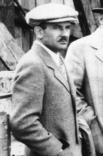
In short what we do,as petroleum geologists (Figure 10),has probably not changed in 50 years.How we do it,has been transformed incredibly.
One consequence of our elevated efficiency,is that we now spend almost all of our days in front of computer screens retrieving,shuffling,analyzing,and synthesizing enormous amounts of divergent data.I wonder if this focus on data management has,to some degree, alienated us from that “primal” interest indicated in Figure 1.Perhaps this in part reflects the very ambivalent response to the final question from the Fall survey – do you consider yourself (or would you be comfortable being introduced as),a geoscientist (Figure 11)?
If hiring is not accelerated, then in 20 years the industry will face a 34% shortfall with respect to 2004 levels. Total new jobs to meet shortfall is 1,310 In 10 years the shortfall will be 11%.
Assumptions:
-new hiring equals average for years 2001, 2002, 2003 -25% of workforce between ages of 55 and 65 will retire early -no one over 65 is in workforce
MappingCorrelationDatabaseQueries X-sections construction Reports&PresentationsOperationsCore/cuttingsLogAnalysisDescriptionBudget&ApprovalsWellsiteLandSites ReserveCalculationsRiskAssessmentsLandExpiries PartnerNegotations DST’s&PressureTransientStudiesRegulatorySubmissionsSeismicinterpretation
Figure 9.Workforce demographics.
Figure 10.Relative time expended on various tasks.
Figure 11.Do you consider yourself a geoscientist?
2004 CALENDAR OF EVENTS
DATE: March 9-11,2005
EVENT: 2005 Gussow Geoscience Conference - Coalbed Methane:Back to the Basics of Coal Geology
LOCATION: Canmore,Alberta
INFORMATION: Get fired up for a discussion on one of the hottest topics in the industry while relaxing at the Radisson Inn,nestled in the beautiful Rocky Mountain setting of Canmore,Alberta.The 2005 Gussow conference will focus on geological aspects around Coalbed Methane (CBM) and Natural Gas from Coal (NGC) reservoirs.Sessions will focus on the following themes:geological controls on CBM,microscopic and geochemical coal studies,technical aspects of CBM from the lab to the field,and CBM in the Western Canada Sedimentary Basin.Preceding the conference is an optional short course to be held in Calgary. The 2005 Gussow Conference is presented by the CSPG in partnership with the Canadian Society for Unconventional Gas (CSUG),The Society for Organic Petrology (TSOP),and the Canadian Society for Coal and Organic Petrology (CSCOP).Members of any of these organizations are eligible for member’s registration rates.
Early bird registration will open December 1,2004.
Rates:• Early Bird (Member):$250.00
• Early Bird (Non-Member):$350.00
• Regular Registration Rates will commence on February 1,2005.
• Member:$350.00
• Non-Member:$450.00
Conference registration closes March 4th,2005. Conference registration fees include admission to the ice-breaker on the evening of March 9,the keynote address dinner on March 10,the keynote address lunch on March 11,as well as continental breakfasts, coffee breaks,and buffet-style lunches throughout the conference.Accommodations at the Canmore Radisson Inn and Conference Centre are available to conference delegates at preferred rates.
DATE: April 6-7,2005
EVENT: 2005 Annual Calgary Mining Forum
LOCATION: Ramada Hotel Downtown,Calgary,Alberta
INFORMATION: The 2005 annual Calgary Mining Forum will take place on April 6-7 at the Ramada Hotel downtown.As always,this mining-industry conference and trade show will include presentations by mineral-exploration companies,services companies,consultants,and government geologists.The topics range from exploration methods to background science to specific prospects and investments opportunities.Short courses on exploration-related themes are also in the works.With low-cost registration,the usual Forum attendance is a mix of geologists,exploration and service companies,and investors.Details are posted in the Calgary Mineral Exploration Group website www.meg.calgary.ab.ca;please also contact Paul Hawkins (phawkins@shaw.ca.403-242-7745) or Henry Lyatsky (lyatsky@telus.net,403-282-5873).Western Canada and Alberta have a vibrant mining industry. Come on out to the Forum, and find out about it!
DATE: May 15-18,2005
EVENT: Halifax 2005 - a Joint Meeting of the Geological Association of Canada,the Mineralogical Association of Canada,the Canadian Society of Petroleum Geologists,and the Canadian Society of Soil Sciences.
INFORMATION: The historic seaport provides a wealth of opportunities to investigate Nova Scotia’s heritage and culture,juxtaposed with all the amenities of a modern urban centre.Extensive seacoast exposures and a diverse geological history provide the backdrop for a rich technical program.The “Building Bridges” theme of the meeting is both symbolic of the harbour bridges that distinguish our Halifax – Dartmouth skyline,and a metaphor for the multi-disciplinary program that is designed to bridge the gaps within geoscience,and between geoscience and society.We look forward to providing you with the opportunity to discover the charms of our beautiful city and renew the ties that bind our geoscience community.For more information please visit www.halifax2005.ca.
DATE: June 19-22,2005
EVENT: AAPG Annual Convention in Calgary,Alberta –Exploring Energy Systems
LOCATION: Round-up Centre,Calgary,Alberta
INFORMATION: For more information please visit http://www.aapg.org/calgary/index.cfm
DATE: August 8-11,2005
EVENT: Earth System Processes 2
LOCATION: Calgary,Alberta
INFORMATION: Sponsored by the Geological Society of America and the Geological Association of Canada Web site:www.geosociety.org/meetings/esp2 Theme Session Proposal submission deadline: September 15,2004. Abstract submission deadline: April 26,2005.Description:International meeting, interdisciplinary focus.Earth’s surface environment as a complex web of feedbacks among the biota, oceans,atmosphere,lithosphere,and cryosphere. ESP 2 will discuss advances made in the last four years toward better understanding the nature of these feedbacks in the modern world,how they have emerged and evolved over the Earth’s history, and how they will respond to human perturbations in the future.For more information,contact:Diane Matt,P.O.Box 9140,Boulder,CO 80301-9140 1-303-357-1014 (phone) 1-303-357-1074 (fax) dmatt@geogociety.org (e-mail).
DATE: November 13-17,2005
EVENT: SETAC North America 26th Annual Meeting
LOCATION: Baltimore,Maryland
INFORMATION: The Society of Environmental Toxicology and Chemistry (SETAC) will hold the SETAC North America 26th Annual Meeting at the Baltimore Convention Center in Baltimore,Maryland, November 13-17,2005.
This year’s theme is “Environmental Science in a Global Society:SETAC’s Role in the Next 25 Years.” More information can be found on the Society’s website www.setac.org.
JACK PORTERVIGNETTES OF CANADIAN PETROLEUM GEOLOGY
Continued from the January Reservoir
Martin Frobisher’s Third Voyage to his “Frobishers Streytes” to mine for gold
After examining the natives’ sealskincovered tents and boats and the utensils and garments found in their tents,Frobisher realized that the inhabitants of this encampment were similar to those natives, which he had encountered in Meta Incognita during his previous two visits.He concluded, from the likeness of their artifacts,that Friesland / West England (Greenland) was affixed to Meta Incognita.Frobisher further reinforced his reasoning on the evidence that the bodies of water fronting their coastal areas both contained ice pans and icebergs. He deduced,from these premises,that a huge bay extended to the northwest.It was this “bay” that would be later explored by another English mariner,John Davis,during his expeditions of 1585,1586,and 1587 in his attempts to discover a Northwest Passage. This “bay” was subsequently designated Davis Strait.
The concept of a perpetual “Frozen Sea”,as originally applied to the body of water surrounding Iceland,was challenged by Captain George Best of the Anne Francis, who had traveled with Frobisher’s fleet on the latter’s third voyage.In his account of the Expedition,which was published following the fleet’s return to England,Best argues that “No sea consisting of salt water can be frozen.” and further,“It seems impossible for any tidal water to freeze.” In regards to the ice pans and icebergs,he asserts “Those islands of ice which we sometimes meet 100 miles from land taste fresh when you gather them out of the salt sea and,when melted, become sweet and wholesome water.” (Ibid., Kenyon,W.A.,1975,pp.81,82).
During his second voyage,Davis,with a party of his seamen,went ashore on Greenland’s southwest coast near the site of a former Icelandic colony.Here they were met by a swarm of natives in their kayaks.To Davis’ amazement,he was greeted with a handshake by one of the natives who,as well,bowed and kissed the back of his hand. This vestigial social custom of European origin had survived for over a 200-year period,following the disappearance of the Norse settlements in Greenland.Equally astonishing to Davis was the discovery of a burial site over which a cross lay.It had been found by the master of Davis’ Mermaid who,
at the time,was in search of firewood. Apparently,those interred were the descendents of members of a Norse colony, which had been established there some 600 years earlier.This event had been unbeknownst to Davis (Ibid.,Oleson,Tryggvi J.,1963,p.160).
Frobisher’s fleet departed from Greenland / West England on June 20,1578 to cross
Davis Strait for “Frobishers Streytes” in Meta Incognita.In his last view of West England from his flagship Ayde,he named a conspicuous cliff Charing Cross,after its namesake in London.It was during this first day,in a fog-shrouded sea,that the fleet unexpectedly encountered a large pod of whales.A vessel of the fleet,the Salamander, collided with one of the creatures just as it
(Continued on Page 22...)
Congratulations to Angelo Speranza of Husky Energy Inc. who was the lucky winner of the draw prize provided by geoLOGIC systems ltd. at the CSPG Technical Luncheon Christmas social held on Thursday, December 9 at the Telus Convention Centre.
Angelo won Theatre Calgary tickets to A Christmas Carol, dinner for two at Teatro restaurant and was escorted for the evening by Unbelievable Limousines.
Look forward to additional events planned for the upcoming Technical Luncheon series for 2005
Thank you!
The CSPG would like to extend a special thank you to geoLOGIC systems ltd. for their continued partnership and investment in the Technical Luncheon Program as our Marquis Corporate Sponsor. We look forward to our continued partnership in 2005!
had surfaced to blow.The force of the impact had rendered the Salamander immobile.On being struck,the unfortunate behemoth uttered “a great and ugly noise”. This desperate knell may have been a foreshadowing of the navigational ice hazards and severe storms that Frobisher’s fleet would encounter in its attempt to reach Anne Warwick (Kodlunarn) Island in Countess of Warwick Sound (Ibid.,Morison, Samuel Eliot,1971,p.533).
For the next two days the fleet was enveloped in a dense fog.Verbal communication between the disarrayed vessels became hopeless.A continuous sounding of trumpets and beating of drums was ordered by each of the ship’s captains and masters in an attempt to keep the fleet consolidated.By June 22nd,the mist had lifted,enabling the ships to reassemble.It was during this clearing that the crew of the Salamander observed a dead and bloated whale being rocked by the waves.The following day the entire fleet proceeded out to sea in a northwesterly course,only to be buffeted by a gale-like storm in a swollen sea with menacing icebergs.It was during this ordeal that the Michael,commanded by Captain Kinnersley,became separated from the fleet.Later,on June 26th,Captain Edward Fenton’s Judith,likewise,lost contact with her sister ships.Frobisher,in anticipation of such eventualities occurring, had forewarned the captains and masters of his fleet’s vessels to proceed directly to Anne Warwick Island to rendezvous with the other ships of his fleet rather than returning to England.
During Frobisher’s third voyage to his “Frobishers Streytes” in the summer of 1578,the Labrador Sea,Davis and Hudson Straits,and adjoining terrain had been plagued with unusually cool weather, accompanied by frequent gales of freezing rain and snow.In the intervening periods of calm,fog and mist enveloped the coastal areas and adjacent sea,preventing the measuring of latitude.To compound these navigational problems,the powerful force of the Labrador current,which flows south as it fronts the eastern coastline of Baffin Island is,in part,funneled into Hudson Strait prior to continuing southeastward off Labrador. Although,from his previous two voyages, Christopher Hall had become cognizant of this phenomenon,the fleet’s admiral,Martin Frobisher,had underestimated its significance as a navigational factor.This route has subsequently taken on the colorful sobriquet “iceberg alley”.Apart from climatic hazards,the consequence of Frobisher’s,seemingly unintentional, disregard of the Labrador current,resulted (...Continued
in his fleet being,at times,disoriented, causing delays and setbacks in reaching Anne Warwick Island.
Chief Pilot Christopher Hall,aboard the Thomas Allen,sighted Meta Incognita on June 27th and recognized a landmark he believed to be Loks Land (Hall’s Island).His vessel had been reconnoitering north of Frobisher’s fleet with the intent of identifying the entrance to “Frobishers Streytes”.After assessing what he believed to be the sought-after “strait”,Hall observed that its entrance was blocked by an impenetrable mass of ice pans and icebergs. Accordingly,Captain Gilbert Yorke was deterred from attempting to gain entrance. Subsequently,the Thomas Allen sailed south through ice-clogged water and located their sister members of the fleet rendezvousing in open water off Queen Elizabeth Foreland (Resolution Island).To no surprise to Hall and Yorke,the southeasterly winds of the preceding storm,abetted by the Davis Strait / Labrador Current,had likewise formed an ice barrier to the northeast entrance to Hudson Strait.Unbeknownst to Frobisher, the force of the offshore current had displaced his fleet some 70 miles to the south.Not having been able to measure his latitude owing to storms and frequent foggy weather,he assumed he was facing the entrance to his “Frobishers Streytes”.His compass navigation failed to keep his fleet on course.
Christopher Hall,along with Captain Gilbert Yorke and his crew of the Thomas Allen, arrived at the entrance to this strait on July 2nd to rejoin the fleet.Both,through their navigational skills,had been fortunate to have their vessel escape the treacherous sea ice that they had encountered during their southward passage.The following day,with the weather having improved,Frobisher gave an order to his captains and masters to proceed into the congested ice fields blocking the entrance to the strait.He believed,by penetrating this barrier,that his fleet would gain access to relatively ice-free navigable water,which would afford easier access to Countess of Warwick Sound and Anne Warwick Island.
An attempt by Hall,to convince the commanders of the fleet’s vessels to reassess Frobisher’s tactic,was in vain. Although he was able to convey his warning to the masters of the Dennis and Hopewell ,both,in the end,were not prepared to contest Frobisher’s order. These two ships joined the others,each sailing in single file,toward a massive containment of ice pans and icebergs.Hall
PALEOKARST IN THE PEKISKO
Paleokarst in the Pekisko, west-central Alberta:its origin, recognition from horizontal and vertical well logs,and impact on reservoir development
INTRODUCTION
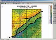
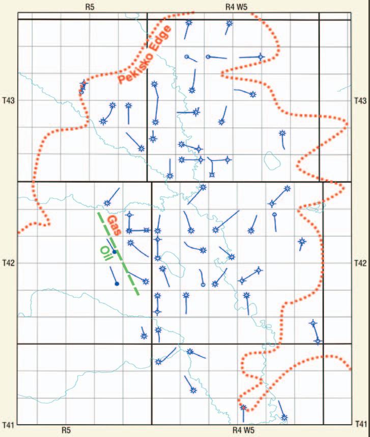
The Mississippian Pekisko Formation of west-central Alberta has been exploited extensively in the Gilby North-Wilson Creek area (T41-43,R3-5W5;Figure 1).While vertical wells have successfully produced from the most porous limestone (typically with mouldic porosity) and coarse-grained, dolomitized lithologies,most production in the tighter,largely undolomitized grainstones and packstones has been achieved only since the advent of horizontal drilling.In the area described,some 56 horizontal wells have been drilled since 1997,the great majority by Encal/Calpine and Petro-Canada.These have resulted in 46 successful producers (43 gas and 3 oil) with 12-month initial production (IP) rates from 3 to 376 e3m3/d (106 mcf/d to 13.3 mmcf/d) and cumulative production to date of 0.1 to 17.8 BCF per well (mean 2.2 BCF).
Stratigraphic trapping of hydrocarbons occurs up to 12 kilometers downdip from the Pekisko erosive edge (Figure 1).Farther back from the edge a narrow oil leg separates the gas-prone reservoir from water-saturated lithologies;the position of this boundary is irregular,and clearly offset by either small-scale faulting and/or variably developed porous and tighter zones.Reservoir quality appears to be related to fracturing and secondary porosity development with both intercrystalline and mouldic porosity (Figure 2).
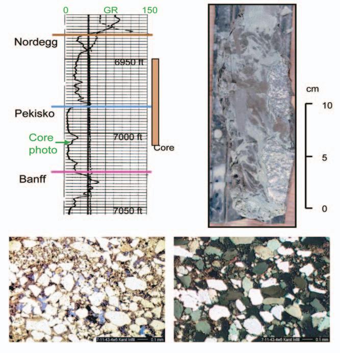
The Pekisko overlies peritidal dolomudstones, dolomitized packstones,and lime mudstones of the uppermost Banff Formation with locally developed unconformity.It is dominated by crinoidal grainstones containing abundant ooids and coated grains,brachiopods,and bryozoans,which were deposited as shoals in a fully marine,inner shelf setting.Other primary lithologies in the region include muddy packstones (outer shelf) and finegrained dolomudstones (probably deposited under peritidal,lagoonal conditions).With the exception of the muddy packstones,all lithologies typically exhibit a clean Gamma Ray (GR) log signature of less than 15 API units. Muddier sediments,occasionally partially dolomitized,are generally confined to the lowest five metres of the Pekisko.Above this level,few stratigraphically-related muddy lithologies are present;core examination
BY S. HENRY WILLIAMS
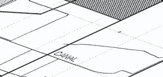
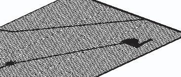
Figure 1.Map showing distribution of Pekisko horizontal wells studied in Gilby-Wilson Creek and approximate location of Pekisko erosive edge.Position of oil-gas contact shown for T42,R5W5.
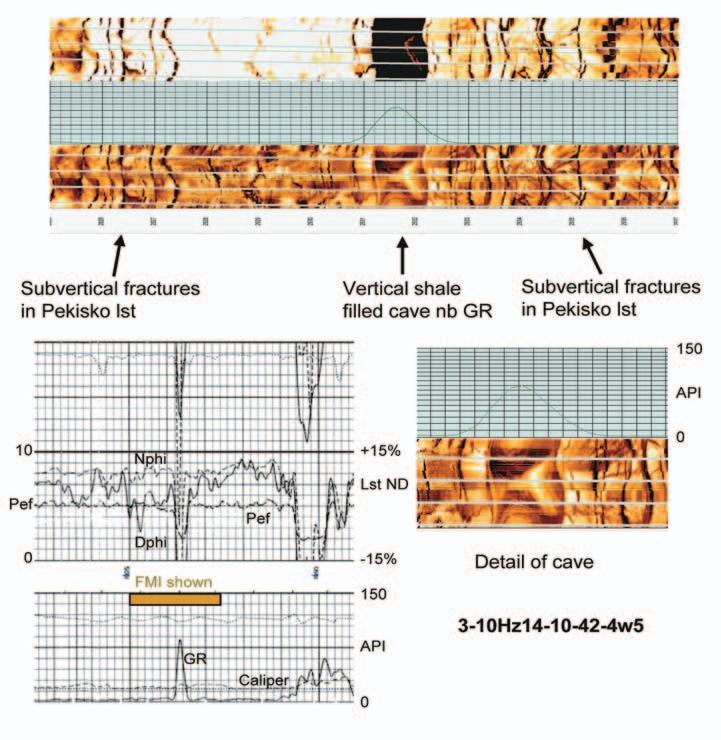
demonstrates that almost all intervals with elevated or spiky GR log response are related to subsequent karst development and infill of solution features by shales and sandstones. Other evidence of paleokarst in the Pekisko is demonstrated in both vertical and horizontal wells by low Photoelectric Factor (PEF) readings,anomalously high porosities on limestone-scale Neutron-Density (N-D) logs, and rotated blocks on Formation Microimager (FMI) logs.While some of the shales are bedding-parallel,many can be seen to be high-angle,cross-cutting features both in vertical cores and on horizontal FMI logs.
KARST FORMATION AND SEDIMENT INFILL
– PROCESSES AND RECOGNITION
Solution karst may occur in a number of settings. These including meteoric (predominantly via dissolved CO2 giving carbonic acid combined with oxidation of vegetation),deep burial
(solution through hydrothermal activity or H2Sproducing sulphuric acid),and in mixing zones (mixing of fresh and marine water in coastal settings) (Ford 1988;Wright 1991).The effects discussed within the present study are all related to meteoric dissolution,based on the predominance of vertical or subvertical structures in the Pekisko.This corresponds to the “early karst” phase of Choquette and James (1988).The kinds of structures formed during karsting rely on a number of variables,including climate,duration,vegetation,and rock type among others (Budd et al 1995).Of particular importance to Pekisko karst development are the original porosity-permeability characteristics of the rock and the variable climate from Mississippian through mid-Cretaceous times.
Karst dissolution is most typically initiated by the subaerial exposure of carbonates and introduction of CaCO3 undersaturated
meteoric waters (Kerans 1989).In poorly cemented carbonates (typically recently deposited),diffuse (interparticle) flow predominates with only minor utilization of fractures (White 1969;Choquette and James 1988;Kerans 1989),whereas in carbonates with low porosity and permeability,conduit (fracture) flow predominates.Resulting karst features where diffuse flow predominates include surface caliche deposits (formed by continual evaporation and recharge of water in highly porous soils and limestone) and limited cave formation reaching only several metres depth.Limestones with low porosity and permeability tend to develop little or no caliche,have abundant fracture-related conduits,and cave systems extending anywhere up to several hundred metres below the surface.In addition to these macroscopic features,porosity can also be developed on a microscopic scale through the leaching and dissolution of limestones (see Budd et al 1995).
Meteoric macrokarst development in wellcemented carbonate settings begins with dissolution of fractures into a series of grooves and flutes;Bocker (1969) suggested that fractures only 10µm wide are needed for dissolution processes to begin via laminar flow. Once these have widened to between 5 and 15 mm,turbulent flow occurs,speeding up the dissolution process via more active dissolution and mechanical abrasion;it is this lower limit that Ford (1988) defines as marking initial cave formation.At this point,vertical,subvertical, and horizontal cave systems develop within the vadose and upper phreatic zone,with cavities being enlarged by collapse and brecciation of cave roofs and dolines (sinkholes).The vadose zone (above the mean water table) is dominated by vertical and subvertical structures with occasional “canyon-like” caves,while the more typical caves characterized by a circular or ovoid cross section develop in the upper phreatic zone at the level of the water table.As karst development continues through time,the vadose zone becomes progressively deeper through solution.
Sediment deposition can occur both during cave formation and following a change in base level (such as sea level rise).In the former case, deposits include speleothem (limestone deposits such as stalactites and other dripstones),cave floor breccias formed by roof collapse,and fine-grained clastic material transported from the surface by flowing water (Ford 1988;Loucks and Handford 1992). Clastic material is dominated by finely laminated green,grey,and black muds and silts which are commonly laminated parallel to the karst surface (whether horizontal or vertical). Higher energy flow may lead to the
(Continued on Page 30...)
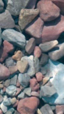
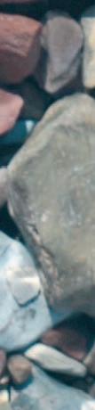
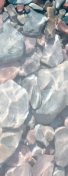
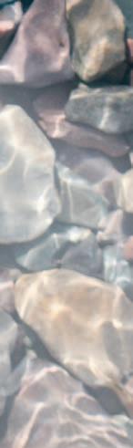
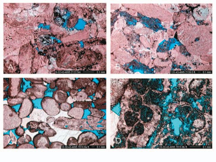
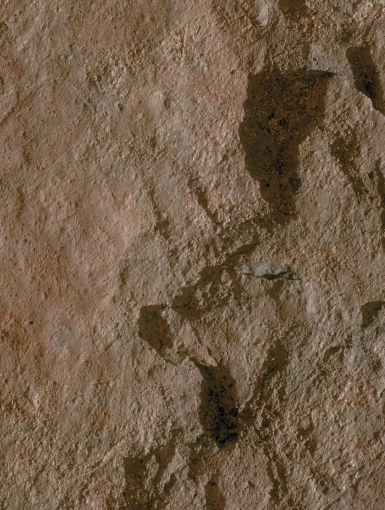
Figure 2.Porosity development in the Pekisko limestone as seen in vertical producing wells,from cores in Wilson Creek unit.A).Slightly leached intercrystalline porosity,6-32-43-4W5,2122.5m.B) More heavy leaching of grainstone fragments giving mouldic porosity,7-31-43-4W5,2139.0m.C) Well developed interparticle porosity, 10-30-43-4W5,7016.8ft.D).Leaching of micritized bryozoan giving mouldic porosity,10-30-43-4W5,7016.8ft.
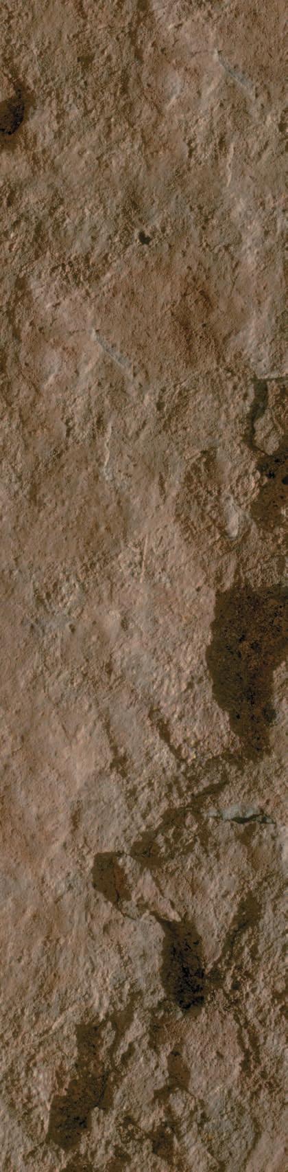
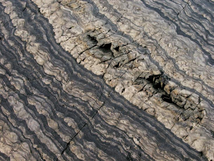
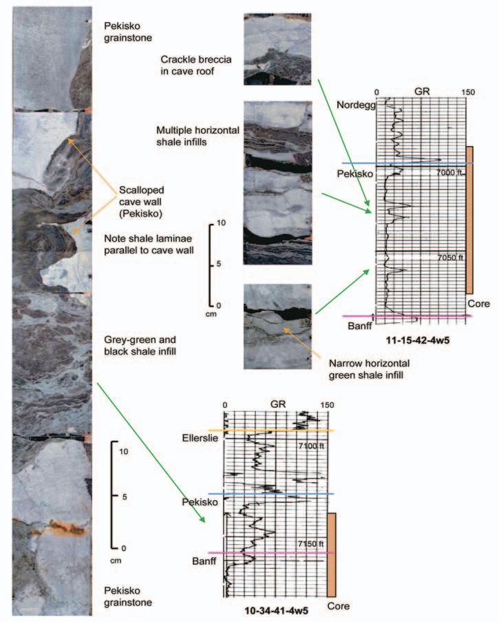
Figure 3.Pekisko cores showing typical shale infill of paleokarst solution features and Gamma Ray log response.
introduction of coarser material such as fine sand and silt;these can exhibit a variety of sedimentary structures more commonly associated with surface flow such as crossbedding and grading.During transgression,an open cave system may be entirely filled with marine sediments which may be either clastic or carbonate dominated;infilling may also occur through surface fluvial processes.
The term “paleokarst” refers to karst features formed during a geologically earlier time. Wright (1991) divided these into:relict paleokarst (surface karst in geologically recent rocks which developed under different climatic conditions than in which it is now found,relating mostly to Cenozoic karst); buried paleokarst (where karsting occurred prior to burial by younger sediments);and exhumed paleokarst (pre-existing paleokarst which is now being exhumed and exposed to further karstification).Polyphase karsting (related to the last two of these) is relatively common and is probably what is present in the Pekisko of west-central Alberta.
RECOGNITION AND TIMING OF PALEOKARST DEVELOPMENT IN THE PEKISKO
In addition to erosion at the upper and lower contacts of the Pekisko,intraformational paleokarst features are developed as:1) Vertical,inclined,and horizontal green-shale filled fractures < 1cm wide;2) Sand-filled sink holes 1 to 5m wide;and 3) Fractures and cave deposits with collapse breccias and laminated green and black shale matrices varying from 1cm to several metres extent.Paleokarst infill features visible in core appear to be very similar to those described from the Lower Ordovician Ellenburger Group of West Texas (Kerans 1990),a carbonate sequence with similar lithologies to the Pekisko and over 3 billion BOE reserves.
Evidence for these paleokarst features in the Pekisko is seen in cores (Figures 3-4),drill cuttings (Figure 5),and geophysical logs (Figures 3-5).Indicative log responses include high Gamma Ray (GR) spikes,low Photoelectric Factor (PEF) readings, anomalously high porosities on limestonescale Neutron-Density (N-D) logs,and rotated blocks on Formation Micro-imager (FMI) logs (Figures 6-7).The occurrence of drill-string drops during drilling and cavities shown on caliper logs,as have been used to detect the presence of open caverns in some other karsted reservoirs (e.g.,Dembicki and Machel 1996),cannot be used in the Pekisko as most caves appear to be sediment-infilled. During the drilling of horizontal wells, paleokarst features are visible on MWD GR logs as elevated GR readings over 45 API and are commonly associated with spiked gas
Cored Interval
4.High-angle cavern in Pekisko filled with green and grey shale plus fine-grained,pale-green sandstone, 7-11-43-4W5.Note appearance of fine-grained quartz arenite under plane polarized and cross-polarized light.
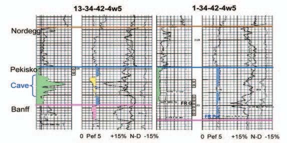
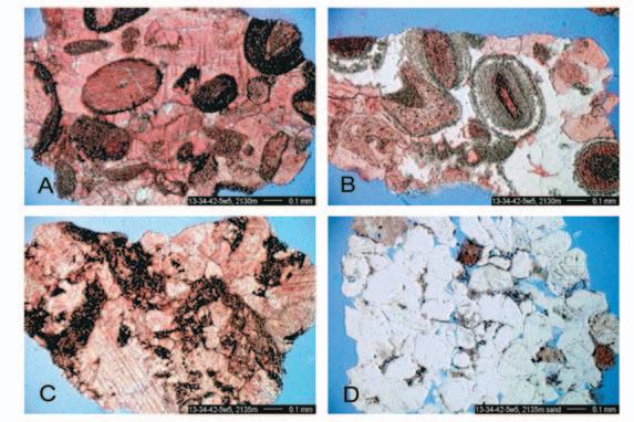
Figure 5.Contrasting log response of typical Pekisko (1-34-42-4W5) and Pekisko with cave development (13-34-424W5) only 1.2 kilometres away.Note GR,PEF,and N-D log response indicating clastic infilling of cavern.Drill cuttings from 13-34-42-4W5 show:A) Tight,oolitic grainstone,2,130m.B) Partially silicified oolitic grainstone,2,130m.C) Deformed,oil-stained grainstone in cavern,2,135m.D) Fine-grained quartz arenite cavern infill,2,135m.1-34 had initial production rates of 44 e3m3/d,while 13-34 had rates of less than 10 e3m3/d commingled with Rock Creek.
Figure
detector readings of 2,000 units or more. These may be distinguished from open fractures,which have low GR readings and a long “tail” on the gas spike.Unfortunately, N-D logs were run in only 34 of the 56 Pekisko horizontal wells drilled in the area, while FMI logging was carried out in only three.Thus,critical log-based observations and conclusions can be made on only 60% of the total data set.
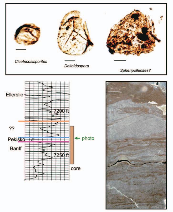
Evidence of paleokarst development is most common in wells that have been drilled in areas where the Pekisko is subcropping directly beneath the Middle Cretaceous Ostracod and Ellerslie formations,particularly within Cretaceous incised valley systems.It is, however,also present in wells with several tens of metres of overlying Jurassic strata (Nordegg,Poker Chip,and Rock Creek) separating the Pekisko from the Cretaceous.
This suggests that there may have been multiple karsting events;the first would have been during Pennsylvanian to earliest Jurassic times,which would have been the event of longest duration (some 120 My) during which the later Mississippian Shunda was removed (assuming it to have originally been present over the entire region).There is no record of Permian or Triassic sediments in the study area;these may either have been removed or never deposited,although it may be significant that there are no “anomalous” lithologies preserved in Pekisko paleokarst, which might represent rocks of this age.
Pennsylvanian-age karsting of Mississippian carbonates has been documented widely from the North American craton (Meyers 1988; Sando 1988;De Voto 1988;Palmer and Palmer 1989;Esteban 1991;Demiralin et al 1993; Dixon and Saller 1995),where it has led to the formation of economic hydrocarbon and Mississippi Valley-type (MVT) mineral deposits (e.g.,Madison Limestone of Wyoming and Boone Formation of Missouri,Oklahoma,and Kansas).The Pennsylvanian of the low-latitude North American Midcontinent was characterized by a relatively warm,humid climate (Walker et al 1991),which would have promoted rapid and deep karst development. Evidence for Permian and Triassic karsting is less common,and the climate would have been relatively arid.Documented Permian karst with hydrocarbon reserves (e.g.,the Yates Field of West Texas) appears to have been related to marginal marine mixing zones (Craig 1988;Tinker et al 1995).
By early Jurassic times,the Pekisko had probably been eroded from the east of the study area,shown by local onlap of Nordegg directly onto the earlier Mississippian Banff
(Continued
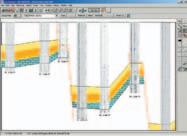
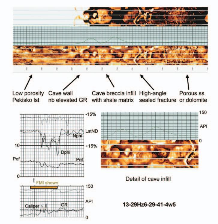
Figure 6.FMI and N-D logs showing vertical shaleinfilled collapse breccia in a horizontal Pekisko wellbore.
Figure 7.FMI and N-D logs showing vertical fractures and shale-infilled cave in a horizontal Pekisko wellbore.
Formation along the present Pekisko edge. Although the basal Nordegg commonly rests on a peneplaned surface,there is local (apparently fault-controlled) relief in the Mississippian,which has resulted in deeply incised valleys filled by highly productive early and middle Jurassic “J-Sands” to the south-east of the study area (Hopkins 1981).
It is here assumed that the karst features observed in the Pekisko were formed over a long period of geological time,spanning the Pennsylvanian to early Cretaceous.It does, however,appear that the most spectacular and extensive karsting recognized in core and in vertical and horizontal well logs occurs along Cretaceous incised valley floors where the Pekisko directly underlies Ellerslie and Ostracod sands and shales of Middle Cretaceous (Albian) age.Although marking a shorter (although still long) interval of exposure (maximum 60 My),this period of geological time was characterized in western Canada by tectonic uplift and a warm,moist climate,both of which probably contributed to elevated rates of karst formation.
The majority of paleokarst-infill in the Pekisko comprises pale-green and grey waxy shales, lithologies commonly associated with carbonate-related unconformities throughout the geological record (personal observation) and undiagnostic in terms of age recognition. Larger,metre-scale sand-filled solution features have,however,been recognized both in several cores and in a number of horizontal wells where they give anomalously high N-D porosity readings and elevated gas response. Petrographic study has shown the sands to be fine-grained quartzarenites lacking chert (Figures 4 and 5).Although not necessarily diagnostic,many medium- to coarse-grained Nordegg and Lower Mannville sandstones contain abundant chert,while chert is invariably absent in the finer-grained sandstones of the Rock Creek.This somewhat tenuous evidence may point to a Middle Jurassic age for at least some of the solutioninfill sandstones.
An attempt to palynologically date the karst infill sediments by Elliott Burden of Omnichron Resources (St.John’s, Newfoundland) met with limited success;a number of samples yielded fluffy sapropellic material and corroded woody fragments,but only one sample from a cross-laminated,dark grey shale (probable cave floor deposit) in core from 10-21-41-4W5 yielded agediagnostic palynomorphs (Figure 8).These poorly preserved spores and pollen,including Cicatricosisporites,Deltoidospora,and Spheripollenites? point to a (?Early) Cretaceous age,suggesting Lower Mannville or early Cretaceous sedimentation.
Figure 8.(?Early) Cretaceous palynomorphs from crosslaminated siltstone representing probable cave-floor sediments, 10-21-41-4W5 core,7232.5m (scale bar = 10µm).
Palynomorph sample processed and identified by Elliott T. Burden,Omnichron Associates Inc.,St.John’s,Newfoundland.
IMPACT OF PALEOKARST ON PEKISKO RESERVOIR DEVELOPMENT AND PRODUCTION
An attempt to match production success in horizontal wells with a number of variables, including length and orientation of horizontal leg,distance from edge,% karst present,net porous dolomite,and net porous limestone met with limited success.Little correlation was seen using simple bivariate or multivariate analysis.Surprisingly,it appears that neither initial production rates nor cumulative production are directly controlled by any of the variables measured,including overall porosity,distance from edge,or percentage of karst lithologies.It is thus concluded that production success is controlled at least in part by one or more variables unmeasured in the majority of wells.The most likely factor,in the author’s opinion,is the presence of solution-enlarged,open fractures,related to karst development.These are normally recognizable only on FMI logs,and even then only with great care as open fractures filled with drilling mud can easily be confused with tight sediment-filled fractures.Although sand-
filled karst features encountered in horizontal wells commonly possess very high N-D log porosities of up to 18% and typically show high gas response during drilling,they do not appear to contribute to production,possibly due to limited volumetric extent.
Paleokarst macro-features in the Pekisko appear to commonly run subparallel along fracture zones,the presence and orientation of which may sometimes be deduced prior to drilling through subsurface mapping.The majority of fractures in the Wilson Creek area are related to a conjugate fault set oriented ENE and WSW.During the drilling of horizontal wells over the past six years,it has become evident that open fractures often lead to the most productive wells.Unfortunately, when the fractures are shale-filled they vertically partition the reservoir and can lead to reduced recovery in horizontal wells.Given that shale-filled paleokarst features are more common where Cretaceous sediments rest directly on the Pekisko,horizontal wells are more likely to be successful if drilled in areas
(Continued on
where the Pekisko is overlain by at least a partially complete Jurassic sequence.In terms of orientation,it would be expected that horizontal wells with azimuths which cross the regional fracture trends should have better production rates than those which run parallel to them.It appears,however,that other variables in terms of local porosity development tend to blur analysis of this trend.Furthermore,if these fractures are infilled it will reduce,rather than enhance, production.
Finally,in this area it appears that matrix porosity generally decreases towards the Pekisko edge,in addition to an increase in macroscopic paleokarst features.It is unclear whether this represents a late-stage blocking of earlier porosity,or whether porosity downdip from the edge represents subsequent enhancement of the earlier secondary porosity.This suggests that wells are more likely to be successful if drilled several kilometers downdip away from the Pekisko edge.This is contrary to the conclusions of Reid (1998),who considered the formation of Pekisko microporosity in the Twining oil field (T30-33,R 23-25W4) to have been related to karst dissolution along the Pekisko edge.The complex variables controlling microscopic porosity enhancement versus porosity blocking during karsting is a complex subject (see Budd et al 1995,Matsuda et al 1995,Wagner et al 1995 and Dixon et al 1995),and is beyond the scope of the present paper.
ACKNOWLEDGMENTS
Palynological analysis was carried out by Elliott Burden of Omnichron Resources Inc.,St.John’s, Newfoundland.Olga Knopov assisted with importing the FMI images for this work.Richard Evoy,Wayne Gillis,Dave Halwas,Ted O’Fee, Johanne Lortie,Jeff Lukasik,and Ken Powless of Petro-Canada are thanked for critically reading the manuscript and giving approval for its submission.A preliminary version of this work was presented at the 2003 CSPG Annual Meeting in Calgary.
BIOGRAPHY
After receiving his B.Sc.and Ph.D.from Birmingham and Glasgow Universities in the UK, Henry Williams completed postdoctoral fellowships in Oslo,Norway,and at Memorial University of Newfoundland in St.John’s, concentrating on Ordovician graptolites and stratigraphy.In 1987 he was offered a faculty appointment at Memorial University which he held until September 2000,rising to the rank of Professor and holding the position of Deputy Head (Academic).During this time at Memorial, in addition to his Lower Paleozoic research he carried out contract work on the hydrocarbon potential of western Newfoundland,and formed
Ford, D. 1988. Characteristics of dissolutional cave systems in carbonate rocks. in Paleokarst, edited by James, N.P. and Choquette, P.W. Springer-Verlag, p. 25-57. (...Continued
Omnichron Associates together with Dr.Elliott Burden.Omnichron completed a number of surficial studies and was involved in thermal maturation and biostratigraphic work for the four wells drilled in western Newfoundland by Hunt and PanCanadian.
Henry has published over fifty fully reviewed publications,over eighty shorter articles and abstracts,and has delivered some thirty-five oral presentations at a variety of national and international meetings.He was a Voting Member of the IUGS Ordovician Subcommission from 1989-2004,being Secretary for seven years during this time,and his PhD formed the basis for definition of the Ordovician-Silurian Global Stratotype Boundary at Dob’s Linn in southern Scotland.
Since September 2000,Henry has been employed as a Senior Geologist at Petro-Canada, where he is responsible for development of their properties in the Wilson Creek area,west-central Alberta.In addition to his work on the Pekisko,he is actively involved in mapping and generating new prospects from a variety of Jurassic and Cretaceous clastic reservoirs.
REFERENCES
Bocker, T. 1969. Karstic water research in Hungary. International Association of Science Hydrogeological Bulletin 14, p. 4-12.
Budd, D.A., Saller, A.H. and Harris, P.M. 1956. Foreword. in Unconformities and porosity in carbonate strata, edited by Budd, D.A., Saller, A.H., and Harris, P.M. AAPG Memoir 63, p. vii-xii. Choquette, P.W. and James, N.P. 1988. Introduction. in Paleokarst, edited by James, N.P. and Choquette, P.W. Springer-Verlag, p. 1-21.
Craig, D.H. 1988. Caves and other features of Permian karst in San Andreas Dolomite, Yates Field reservoir, West Texas. in Paleokarst, edited by James, N.P. and Choquette, P.W. Springer-Verlag, p. 342-363. Dembicki, E.A. and Machel, H.G. 1996. Recognition and delineation of paleokarst zones by the use of wireline logs in the bitumen-saturated Upper Devonian Grosmont Formation of northeastern Alberta, Canada. AAPG Bulletin 80, p. 695-712.
Demiralin, A.S., Hurley, N.F., and Oesleby, T.W. 1993. Karst breccias in the Madison Limestone (Mississippian), Garland Field, Wyoming. in Paleokarst-related hydrocarbon reservoirs, edited by Fritz, R.D., Wilson, J.L., and Yurewicz, D.A. SEPM Core Workshop 18, p. 101-118.
De Voto, R.H. 1988. Late Mississippian paleokarst and related mineral deposits, Leadville Formation, central Colorado. in Paleokarst, edited by James, N.P. and Choquette, P.W. Springer-Verlag, p. 278-305. Dixon, J.A.D. and Saller, A.H. 1995. Identification of subaerial exposure surfaces and porosity preservation in Pennsylvanian and Lower Permian shelf limestones, eastern Central Basin Platform, Texas. in Unconformities and porosity in carbonate strata, edited by Budd, D.A., Saller, A.H., and Harris, P.M. AAPG Memoir 63, p. 239-257. Esteban, M. 1991. Paleokarst: case histories. in Paleokarsts and paleokarstic reservoirs, edited by Wright, V.P., Esteban, M., and Smart, P.L. Postgraduate Research Institute for Sedimentology, University of Reading Contribution 152, p.120-146.
Hopkins, J.C. 1981. Sedimentology of quartzose sandstones of Lower Mannville and associated units, Medicine River area, central Alberta. Bulletin of Canadian Petroleum Geology 29, p 12-41.
Kerans, C. 1989. Karst-controlled reservoir heterogeneity and an example from the Ellenburger Group (Lower Ordovician) of West Texas. Bureau of Economic Geology, Report of Investigations 186, p. 1-40. Kerans, C. 1990. Depositional systems and karst geology of the Ellenburger Group (Lower Ordovician), subsurface West Texas. Bureau of Economic Geology, Report of Investigations 193, p. 1-63. Loucks, R.G. and Handford, C.R. 1992. Origin and recognition of fractures, breccias, and sediment fills in paleocave-reservoir networks. in Paleokarst, karst-related diagenesis and reservoir development: examples from Ordovician-Devonian age strata of West Texas and the Mid-Continent, edited by Candelaria, M.P. and Reed, C.L. SEPM Permian Basin Section Field Guidebook, Publication 92-33, p. 31-44.
Matsuda, H., Yoshihiro, T., Nobuyuki, H., and Saotome, J. 1995. Early diagenesis of Pleistocene carbonates from a hydrogeochemical point of view, Irabu Island, Ryukyu Islands: porosity changes related to early carbonate diagenesis. in Unconformities and porosity in carbonate strata, edited by Budd, D.A., Saller, A.H., and Harris, P.M. AAPG Memoir 63, p. 35-54.
Meyers, W.J. 1988. Paleokarstic features in Mississippian limestones, New Mexico. in Paleokarst, edited by James, N.P. and Choquette, P.W. Springer-Verlag, p. 306-328.
Palmer, M.V. and Palmer, A.N. 1989. Paleokarst of the United States. in Paleokarst: a systematic and regional review, edited by Bosak, P., Ford, D.C., Glazek, J., and Horacek, I. Elsevier, p. 337-363. Reid, S.J. 1998. Anatomy of a paleokarst reservoir: sedimentation and diagenesis of the Pekisko Formation in Twining Oil Field, Alberta, Canada. Unpublished M.Sc. thesis, University of Calgary, 265p. Sando, W.J. 1988. Madison Limestone (Mississippian) paleokarst: a geologic synthesis. in Paleokarst, edited by James, N.P. and Choquette, P.W. Springer-Verlag, p. 256-277.
Tinker, S.W., Ehrets, J.R., and Brondos, M.D. 1995. Multiple karst events related to stratigraphic cyclicity: San Andres Formation, Yates Field, West Texas. in Unconformities and porosity in carbonate strata, edited by Budd, D.A., Saller, A.H., and Harris, P.M. AAPG Memoir 63, p. 213-237.
Wagner, P.D., Tasker, D.R., and Barcat, C. 1995. Reservoir degradation and compartmentalization below subaerial unconformities: limestone examples from West Texas, China, and Oman. in Unconformities and porosity in carbonate strata, edited by Budd, D.A., Saller, A.H., and Harris, P.M. AAPG Memoir 63, p. 177-195. Walker, D.A., Galonka, J., Reid, A.M., and Reid, S.A.T. 1991. The effects of Late Paleozoic paleolatitude and paleogeography on carbonate sedimentation in the Midland basin, Texas. in Tomorrow’s technology today, edited by Candelaria, M.P. West Texas Geological Society Publication 91-89, p. 141-162. White, W.B. 1969. Conceptual model for carbonate aquifers. Ground Water 7, p. 15-21.
Wright, V.P. 1991. Palaeokarst: types, recognition, controls and associations. in Paleokarsts and paleokarstic reservoirs, edited by Wright, V.P., Esteban, M., and Smart, P.L. Postgraduate Research Institute for Sedimentology, University of Reading Contribution 152, p.56-88.
The author may be contacted at: S.Henry Williams
Petro-Canada Oil and Gas 150 – 6th Avenue SW Calgary AB,T2P 3E3
hwilliam@petro-canada.ca
CELEBRATE NATIONAL ENGINEERING & GEOSCIENCE WEEK
FEBRUARY 25 – MARCH 6, 2005
Join The Association of Professional Engineers,Geologists and Geophysicists of Alberta (APEGGA) in celebrating National Engineering & Geoscience Week (NEGW), February 25 - March 6,2005.
This year’s theme,Proud Past:Confident Future,reminds us during Alberta’s Centennial year that the men and women who are geologists,geophysicists,and engineers have not only helped build and shape Alberta but continue to provide our province with a confident future by ensuring public safety and well-being.
NEGW is designed to increase public awareness about the important role that geologists,geophysicists,and engineers play in the everyday lives of Canadians.Along with celebrating the work that geoscientists and engineers do,NEGW also promotes the importance of science and technology.
You can help make NEGW 2005 even bigger and better.There are a number of ways to get involved:
• Participate in the APEGGA Food Structure Challenge.Design and build a nonperishable food structure in a public area of your workplace.Upload a photo of your structure to the APEGGA website and APEGGA will send you a certificate of participation.Donate your food items to a charity of your choice at the end of NEGW.
• Plan a challenge between departments within your organization,or with other companies or technical societies.
• Host a coffee session for other employees and tell them about NEGW.
• Visit a school in your area to talk with students about your profession.
APEGGA has other things planned for NEGW:
• The NEGW supplement will be published in both the Calgary Herald and Edmonton Journal on February 24.
• NEGW kick-off events will take place on February 25 in Calgary at Fluor Canada and in Edmonton at City Centre East shopping centre.The public is invited to watch the fun as professional geoscientists and engineers test the performance of catapults that they have designed and built.
• The APEGGA Science Olympics take place February 26 in both Calgary and Grande Prairie and March 6 in Edmonton.Students in each city will compete in a variety of team challenges.Science Olympics are planned in other Alberta cities.Take your children to cheer and watch the team challenges and to participate in hands-on science activities.
• The Provincial School Challenge has students in Grades 1-6 building the lightest and strongest paper chair and Grades 7-12 students building mousetrap cars that travel the farther distance.Offer to help judge the event at a school in your neighborhood or near your workplace.
• A mixer will be held March 1 on the University of Alberta campus for students and practicing members.
• Science nights at elementary schools.
• Science exhibits in shopping malls.
Other organizations are also planning activities in celebration of NEGW.Fluor Canada in Calgary,for example,will host a luncheon for their engineers.Fluor engineers will also make science presentations at Calgary schools during the week.Engineering students at the University of Alberta will again raise money for a worthy cause through the Pi Throw.Students are also holding a NEGW Banquet on March 3 for alumni, professionals,sponsors,faculty,and students.
If your company or organization hosts an event during NEGW,please contact APEGGA to have it added to the events list on the APEGGA website,in The PEGG,and in the newspaper supplement published in the Edmonton Journal and Calgary Herald.
For more information on what’s happening throughout Alberta during NEGW and to get involved,visit APEGGA’s website at www.apegga.org/NEGW and watch for the February editions of The PEGG and e-PEGG newsletters.You can also contact Heather Frantz in Calgary at (403) 262-7714, hfrantz@apegga.org or Jeanne Keaschuk in Edmonton at (780) 426-3990,1-800-6617020,jkeaschuk@apegga.org.
Students watch a demonstration by University of Calgary geoscience students at one of the Elementary Science nights during NEGW.
Students identify minerals at 2004 Edmonton Science Olympics.
Simplifying Seismic
Chapter 2
Dr.Easton Wren
This is the second chapter in a series,which will explain the seismic business in simple terms.Designed specifically for geological personnel in the oil industry,it should provide a forum for information and questions.This installment will focus on the relationship between subsurface geology and the seismic trace.
EVOLUTION OF THE SEISMIC METHOD:
Starting in the 1920s,the prevailing wisdom with seismic techniques was based on the fundamental that large charges of explosives were necessary to simulate earthquake energy in the earth and to achieve some degree of penetration.This resulted in dynamite charges of over a half ton (450kg).The consequences were predictable.In most cases there would be an enormous explosion and inevitably,a large crater (Figure 1).These scars on the landscape represent the earliest issues between the seismic industry and the landowner.It was perhaps with this unintentional destruction of the landscape that the workers on seismic crews were given the less-than-affectionate name of “doodlebuggers”.
Though dynamite remained the primary energy source,there was a gradual reduction in the charge size to the more commonly used 0.5 or 1.0kg.This eliminated damage and produced much higher resolution (more later) but was restricted in terms of its depth of penetration.
rushed through the air (the air-wave) at a speed of 760 miles per hour (300 metres per second) and flooded the geophones, overwhelming the arriving signal.A second noise train ran along the surface of the earth (the ground roll) at a speed of 1,100 metres per second and also masked the signal.Various attempts at trying to reduce this shotgenerated noise resulted in patterns (arrays or groups) of both shots and receivers to establish some cancellation of these effects and enhance the signal-to-noise ratio.To a certain degree these attempts were successful. However,even with the use of arrays today, the industry still considers noise to be one of the major problems affecting data quality.
Ripples in a pond provide a good analogy here (Figure 2).The larger the pebble dropped into the water the taller the splash,the wider the ripple field,and the longer the wavelength (distance from each ripple crest to its neighbour).In contrast,a small pebble will produce a tiny vertical splash,a very small diameter of the ripple field,and a short wavelength.It is also worth noting that a splash in water is a three-dimensional energy field.
Early seismic efforts were constantly thwarted by the sound of the detonated shot.This
With the evolution of the field-shooting process there was a corresponding focus on the design of geophones,their planting on the ground,and their connection to the recording camera system.The early problems involved geophones that were immersed in kerosene and contained in large earthenware pots (hence “jugs”) that required horses to transport more thana couple.The kerosene was used to dampen the response so that the data would be legible as a “wiggle” trace on a strip of photographic paper from the camera/ recorder (Figure 3). If the signal was strong,the galvanometer system was over-loaded and the data was meaningless. With time (by the 1950s) the data was stored on magnetic tape and could be replayed (“played back”) with the application of analog filters to remove noise and scaling (AGC) to increase the signal amplitude.Ultimately (mid-1960s) this gave way to digital recording systems and digital processing to enhance and display the data as seismic sections.
Figure 1.Early seismic shooting.
Figure 2.Ripples as an analogy to seismic waves.
Figure 3.Early seismic recording.
Seismic energy sources saw rapid diversification in the post-World War 2 era. Dynamite had been (and still is) the industry standard because of its consistency,but there was a strong interest in a non-damaging source.An early method was “Thumper” or the weight-drop (Figure 4).This was a large metal block weighing two thousand pounds, lifted up on a crane-winch at the back of a truck and released to thump the ground.It was soon replaced by Vibroseis (Trademark of Conoco),a truck-mounted base-plate which was lowered onto the ground and caused to vibrate with a range of frequencies (Figure 5). This created the opportunity to programme a seismic input signal and incur no surface damage.The most famous photograph in the seismic industry is that of a vibroseis crew working on the Champs Elysee in Paris on a 3D project (Figure 6).No cobblestones were cracked! Vibroseis is the system of choice if there are environmental concerns.It can also be used near producing wells,pipelines, farmhouses,etc.However,its size makes it less-than-useful in rugged terrain such as the foothills.There is a plethora of other land energy sources available but beyond the scope of this article.
Offshore (marine) seismic had its beginnings on the continental shelves of the world in the 1950s.The first offshore energy sources were World War 2 depth charges originally used in submarine warfare (Figure 7).The consequent fish kill was horrific and Canada was the first country to ban the use of depth charges.The earliest seismic operations on the Grand Banks in 1965 had used these primitive sources but by 1969 the industry had switched to the air-gun,a harmless,nonexplosive source with ideal seismic characteristics.In the earlier days,two vessels were used:the first towed the “streamer” or cable with the hydrophones housed in the cable immersed in kerosene,while the second stayed in the rear and triggered the charges.Eventually it became a single-boat operation with the sources towed immediately behind the ship and the cable strung out several thousand metres behind.In 3D marine work there are multiple parallel streamers (up to 15),50 metres apart and several thousand metres long.The longest cables currently in use are 18-kilometre streamers used for detailed work in the North Sea.
The actual data recording system has gone through its share of evolution.The earliest was a primitive camera housed under a tarpaulin.
THE LIVING MODEL
TRACKING AND GUIDING YOUR RESERVOIR DEVELOPMENT:
THE LIVING MODEL TM WORKFLOW FACILITATES A COMPLETELY DIFFERENT APPROACH TO SUBSURFACE CHARACTERIZATION—FROMSEISMIC TO SIMULATION. Instead of each domain passing its results down the chain, an asset team can now share the same reservoir model and focus on the areas that really impact day-to-day business decisions.
PetrelTM is at the heart of the Living Model, complemented by GeoFrame®, ECLIPSE®,Merak® , and InsideReality.TM Blending these Schlumberger Information Solutions technologies and potentially third-party products and services, the Living Model provides a 3D representation of the reservoir with both static and dynamic modeling capabilities. It enables modeling for the masses, uniformity for decision making and models that can be updated easily.
A combination of speed and application depth, the Living Model is the ultimate workflow solution.
This was replaced by a cab on a truck (doghouse) and this has led to the development of the sophisticated control/ recording systems with satellite links and workstations to monitor the data quality and perform interpretation.The person in charge of the recording system is known as the “Observer” and the man-in-charge of the seismic operation is the “Party Chief”.
Each step along the way brought new ideas, improvements and failures,and disappointments and renewed optimism.Gradually an understanding of the behaviour of seismic energy was acquired;its potential,limits,and pitfalls partially understood;and the need for design criteria for each specific geologic objective realized.We shall see how statistical methods were implemented in the 1950s in
the war against noise and how their utilization helped and hindered progress.
These aspects of the seismic method will be discussed in more detail in subsequent chapters.The intention here has been simply to provide an overview of the major steps in the field process and give some insight into the jargon and terminology associated with it.
Note:Questions on this and subsequent articles are invited.Please send any question by e-mail to the author at eastonw@telus.net.A selection of questions with answers will be published regularly.
Figure 4.Weight-drop energy source.
Figure 5.Vibroseis energy source.
Figure 6.Vibroseis crew working on the Champs Elysee.
Figure 7.Depth charges used for marine energy sources.
ANNUAL AWARDS REPORT
BY DEBBIE HORBACHEWSKI AWARDS COORDINATOR
Every year the Canadian Society of Petroleum Geologists and the CSPG Educational Trust Fund present an assortment of awards to deserving individuals for excellence in the science of petroleum and sedimentary geology,distinction in the field of fossil fuel exploration,high quality oral and written presentations,leadership in volunteerism,and exemplary academic performance at the graduate and undergraduate levels.This year, due to a change in presentation format,we will be highlighting each award in the CSPG Reservoir prior to their presentation at the Technical Luncheons.Please check back every month for a new Award spotlight.
On February 8th we will be recognizing two individuals with Tracks Awards for their commitment to the promotion of the Society and for their high level of volunteerism.These gentlemen have truly made tracks for the rest of the membership to follow in! Very few Tracks Awards are handed out each year,and nominations must be accompanied by a citation outlining the level of committee work, and any specific projects for consideration.The Tracks Award consists of a ceramic tile with dinosaur tracks mounted on a wooden plaque.
The Tracks Award recipients for this year are Tony Cadrin and Tim de Freitas.Tony Cadrin is being recognized for his work on bringing the CSPG into the digital age with the Technical Luncheon webcast,as a well as various other committee works.Tim de Freitas is being recognized for his unflagging efforts and outstanding contribution to the CSPG Bulletin.Congratulations and a big thank you to Tony and Tim.
On February 22nd the Link Award will be presented for the best oral presentation at one of the Society’s Technical Luncheons.The recipient must be a CSPG member and the talk must be either geological or a related technical subject.The recipient is chosen by a committee based on a standard grading system that takes the quality of both the content and the presentation into account. The Link Award consists of an engraved pewter mug.
This year’s Link Award winner is Henry Posamentier,for his paper entitled “3D Seismic Visualization From a Geological Perspective: Examples From Shallow Water and Deep Water Environments.Congratulations and well done!
RRSP Solutions
Using your RRSP carryforwards
They say you can’t make up for lost time. But that’s not the case with your registered retirement savings plan.
If you didn’t maximize your RRSP contributions in past years, you can make up the shortfall. Canadians are allowed to carry forward their unused contribution room into later years. The amount you contribute is eligible for a tax deduction in the year you make the contribution.
For example, if you were allowed to contribute $5,000 for the 2003 tax year, but contributed only $3,000, you can contribute the remaining $2,000 in the 2004 tax year or in future years.
There is no restriction on how long you have to make up for missed contributions—you can carry these amounts forward indefinitely. But the sooner you make up for lost time, the further ahead you will be. That’s because your money will start earning income sooner, and it will grow under the tax shelter of the RRSP.
There’s another good reason for using your carryforward as soon as possible. The value of your tax deduction depends on your marginal income tax rate. Recent tax cuts may mean that in the future your tax rate will be lower.
Marginal tax rates (the top rate at which you pay taxes) are falling as a result of tax reductions by the federal government and some provinces. So if your top tax rate this year is 45 percent, a $4,000 carryforward contribution will generate $1,800 in tax savings. If that rate falls to 40 percent in the future, the savings will be only $1,600.
For that reason, it may be smart to borrow money to make use of unused contribution room. Most financial institutions offer special lower-rate RRSP loans. You should strive to pay back the loan with the tax refund generated by your extra contribution.
It’s best to make your maximum RRSP contribution each year. And of course, it is best to start planning for retirement as early as possible. Keep in mind, however, that if you do let time slip by, it’s not too late to catch up. Call us to implement an RRSP contribution strategy that makes sense for you.
2005 AAPG CONVENTION: TECHNICAL PROGRAM
BY ASHTON EMBRY, TECHNICAL PROGRAM COORDINATOR
From a technical perspective,the 2005 AAPG Convention promises to be the biggest and best geological meeting ever held in Calgary. There will be almost 1,000 presentations on many topics of interest to petroleum geoscientists.The presentations are equally divided between talks and posters and each half-day will see 10 talks in each of eight session halls and 100 posters in the poster hall (The Corral).
The latest exploration successes and findings from various exploration areas around the world are an important part of the program. The Western Canada Sedimentary Basin and Canadian Frontier Basins are included in this “global roundup of prospective areas”. A special session on “Recent Major Discoveries” is guaranteed to satisfy everyone’s curiosity.
The latest concepts in sedimentology and stratigraphy are also on display in many sessions.The entire day of talks on “Seismic Geomorphology” will undoubtedly attract many people who will be amazed by the sedimentological details that now can be imaged by 3D seismic.A symposium on “Controls on Carbonate Platforms and Reefs” which is being held in honour of Dr.Wolfgang Schlager,the 2005 SEPM Twenhofel medalist,is a main attraction for all the carbonate enthusiasts.Clastic sedimentation,from nonmarine to deep water and everything in between,is well covered in eight sessions.A special session on “Sedimentation on Mars” will bring new meaning to “frozen in time.”
Petroleum Systems is another major theme being addressed and both oral and poster sessions on the Petroleum Systems of Canada provide excellent overviews of all of our basins.Some of the other sessions in this
theme look at hydrocarbon migration,gas typing and the biodegradation of hydrocarbons.Sessions which focus on tectonics include those on fold and thrust belts,foreland basins,salt tectonics,and the sealing capacity of faults.A full day of talks on “The Interplay of Basin Tectonics and Sedimentation” also promises to attract large audiences.
Unconventional hydrocarbon sources are becoming important and sessions on oil sands,coal bed methane,tight gas,and gas hydrates address this increased interest. Detailed looks at many different reservoirs are found in a number of oral and poster sessions.Environmental issues such as CO2 sequestration,water resources,and alternative energy sources are also featured. The business side of the industry is highlighted in various sessions including those
on reserve reporting and on case histories of successful independents.
There will be 21 field trips to a wide variety of terrific geological exposures from the Burgess Shale to the Athabasca Oil Sands. Fourteen short courses will also complement the technical program.These cover a wide variety of topics and include never-beforepresented courses on carbonate sequence stratigraphy,coalbed methane,and hydrocarbon biodegradation.
In summary,there will be lots for everyone –so be prepared to enjoy an abundance of technical information on many subjects which contribute to the discovery and exploitation of hydrocarbons.
had hoped to communicate with the captains and masters of each of the ships passing the Thomas Allen .Unfortunately he was unable to be heard since the line of vessels was to the windward of him. Reluctantly,Hall and Yorke acquiesced.Of the 13 ships entering the strait,the Thomas Allen was second from the last,having followed Frobisher’s flagship,the Ayde
No sooner had the fleet entered the strait than a storm moved in.Violent southeast winds had driven and consolidated the sea ice behind them,leaving the fleet to be trapped and battered in a confined space. The first and only loss of one of the fleet’s vessels occurred during the initial stage of this storm.The Dennis ’ hull was crushed as she maneuvered through ice pans and the ship submerged within a period of a halfhour.Her sister ships managed to rescue all of her crew.However,the Dennis had on board a large modular segment of the building scheduled to be erected on Anne Warwick Island as shelter for the 100 colonists to be left behind until the summer of 1579.The Dennis was also carrying planking,as well as other materials and provisions,intended for the proposed colony.The loss of this cargo,so essential for the colony’s survival,was to place the
project in jeopardy.Prior to the loss of the Dennis ,four ships of the fleet,being the Anne Francis,Francis of Foy,Moon, and Gabriel ,were lodged in the less consolidated pack ice and managed to extricate themselves.They returned to their point of departure to wait out the storm.The crew of the remaining eight vessels had employed every means to protect their hulls from the ramming and crushing by ice pans that had been agitated by the heavy swells.Every portable spar and plank was put to use by the desperate seamen to fend off the threatening masses of ice.
By July 15th,the storm had subsided and the wind shifted to the northwest.As a result,the pack ice and icebergs were driven out to sea,enabling the entrapped ships to free themselves.After repairing their respective vessels,Frobisher’s fleet retreated to the open sea to rejoin his other four vessels.By July 7th,the regrouped fleet moved to the northwest and after sighting snow-covered terrain through a mist-shrouded coast,Frobisher became unsure as to whether the land on his starboard was the North Foreland of his “Frobishers Streytes”.Apparently,the intensity of the inflow into the strait had
cast doubt in the minds of some of his captains and masters.Accordingly, Frobisher,using the Ayde’s pinnace,sent his representative to each of the ships to solicit the opinions of their commanders as to the fleet’s position.Most agreed that they were in “Frobishers Streytes” or,for fear of offending their admiral,gave their concurrence.Notwithstanding,Chief pilot Hall,convinced the fleet was in an unfamiliar region,was delivered in the Thomas Allen’s pinnace to the Ayde ,where, on conferring with Frobisher,adamantly argued that the fleet was not in “Frobishers Streytes”.The mercurial admiral considered this an affront to his judgment and according to Hall:“was in a great rage & sware by Gods wounds that yt was yt,or els take his life.” Christopher Hall, frustrated by being disparaged by his senior,returned to the Thomas Allen (Ibid., McDermott,James,2001,Martin Frobisher – Elizabethan Privateer,pub.,Yale University,pp.220-225).
To be continued.
The Canadian Society of Petroleum Geologists,in partnership with the Canadian Society for Unconventional Gas (CSUG),The Society for Organic Petrology (TSOP) and The Canadian Society for Coal and Organic Petrology (CSCOP) invite you to join us for the 2005 Gussow Geoscience Conference. The CSPG is pleased and honoured to dedicate this “Banff Conference”-style twoday conference series to William C.Gussow, a past president and Honorary Member of the CSPG who has distinguished himself,his Society,and his country through his pioneering work in geology.The conference is sponsored by the Geological Survey of Canada (Marquee Sponsor) and Burlington Resources (Keynote Sponsor).
Following last year’s successful inaugural conference,the 2nd annual Gussow Geoscience Conference will focus on the geological aspects of coalbed methane reservoirs.This exciting conference will be held at the Radisson Hotel,nestled in the beautiful Rocky Mountain setting of Canmore, Alberta – an ideal intimate setting for discussing issues and innovations surrounding coalbed methane reservoirs with invited speakers and peers from industry.
The conference will open on March 9 with an optional core workshop on Coal cores: examination for source rock and reservoir properties in CSG exploration at the AEUB Core Research Centre in Calgary.Presenters Drs. David Marchioni (of Petro-Logic Services) and Judith Potter (of JP Petrographics) will examine the macroscopic features of coal,coal rank and compositional factors controlling it, and the implications for exploration and production of natural gas from coal.
The plenary session will begin on Thursday with a keynote address by Dr.Dale Leckie of Nexen Energy,followed by two engaging sessions:Geological Controls of CBM,and Petrographic and Geochemical Aspects of CBM.The day will close with a dinner and keynote address by Mr.Andrew Scott of Altuda Energy Corporation.Two sessions will be held on Friday:Technical Aspects of CBM from the Lab to the Field and CBM Case Studies from Around the World,as well as a luncheon keynote address by Dr.Marc Bustin of the University of British Columbia and CBM Solutions.
Don’t delay…registration closes March 4th at 4:00 pm.Registration forms can be downloaded from our website at www.cspg.org.
KEYNOTE SPEAKERS
Dale A.Leckie, Nexen Inc.,Calgary,AB,Canada
Sequence Stratigraphic Setting and the Accommodation Space of Coal Accumulations
Andrew Scott, Altuda Energy Corporation, San Antonio,TX,USA
How to Explore for Coalbed Methane in Frontier Regions with Limited Data:Overview of a Coalbed Methane Exploration Model
R.M.Bustin, Department of Earth & Ocean Sciences, The University of British Columbia,Vancouver,BC,Canada
Factors influencing the Reservoir Capacity of Coal and Gas Shale
SESSION 1:
GEOLOGICAL CONTROLS ON CBM (David Marchioni)
Andrew Beaton, Alberta Geological Survey,Edmonton, AB,Canada
Geological Controls on CBM Production Potential,Horseshoe Canyon Formation,Alberta Plains
Co-author:Olwen Wirth,MGV Energy Ltd.
J.Sebastian Bell, Sigma H Consultants Ltd., Invermere,BC,Canada
In situ Stress and Coal Bed Methane potential in Western Canada
Rusty Riese, BP,Calgary,AB,Canada
New Insights on the Hydrocarbon System of the Fruitland Formation Coalbeds,Northern San Juan Basin,Colorado and New Mexico,USA
Co-authors:William Pelzmann and Glen Snyder
Romeo Flores, U.S.Geological Survey,Denver,CO,USA
CBM Development:Confusing Coal Stratigraphy and Gas Production in the Powder River Basin,Wyoming Co-authors:Dwain E.McGarry and Gary D.Stricker
SESSION 2: PETROGRAPHIC AND GEOCHEMICAL ASPECTS OF CBM (Marc Bustin)
Judith Potter, JP Petrographics,Calgary,AB,Canada
Effects of Coal Facies Variations on the CBM Potential of Lower Cretaceous Mannville Coal from Alberta
Gareth Chalmers, University of British Columbia, Vancouver,BC,Canada
The Influence of Petrographic Composition on Coalbed Gas Capacity
R.Marc Bustin, University of British Columbia, Vancouver,BC,Canada
Variation in Permeability with Production Due to Strain Associated with Methane Desorption:Impact on Coalbed Gas Production from Deep Coal Seams
Prasanta Mukhopadhyay, Nova Scotia Department of Energy,Halifax,NS,Canada
Coalbed Methane and Natural Gas Potential of Carboniferous Coal Basins from Onshore and Offshore Nova Scotia and Geochemistry of Waters associated with Coal Beds
Co-authors:D.Jack MacDonald and Paul Harvey
Maria Masterlez, Indiana University, Bloomington,IN,USA
Isotopic Signatures of Coalbed Gases from High Volatile Bituminous Coals and Associated Roof Lithologies in Indiana, Illinois Basin,and their Genetic Implications
Co-authors:D.Strapoc and A.Schimmelmann
SESSION 3:
TECHNICAL ASPECTS OF CBM FROM THE LAB AND THE FIELD (Peter Warwick)
Charles R.Nelson, Energy & Environmental Research Center,Grand Forks,ND,USA
Best Practice Gas Content Analysis Methods for Low-Rank Coalbed Reservoirs
Chad Hartman, TICORA Geosciences,Inc., Arvada,CO,USA
A Practical and Comprehensive Approach to the Accurate Determination of Gas Storage Capacity in Coal Seams and Shale Gas Deposits
Greg Bell, Coal Gas Technology Co.,Salt Lake City,Utah,USA
Gas Content Variation of Horseshoe Canyon Coals: An Analytical Review of Measurement Results
Thomas Gentzis, CDX Canada,Calgary,AB,Canada
Coalbed Methane Potential in the Sabinas Basin,Mexico
Shane Harrison,SH Consulting,Calgary,AB,Canada
Hydraulic,Water quality and Isotopic Characterization of Ardley coal,Pembina - Warburg Area
Steven Tedesco, Dorado Gas Resources LLC, Centennial,CO,USA
Coal Bed Methane and Shale Gas in the Western Half of the Interior Basin,USA:Emerging From Exploration to Exploitation
H.A von Schoenfeldt, CDX Gas,LLC,Dallas,TX,USA
Unconventional Drilling Methods for Unconventional Reservoirs in the US and Overseas
2004 HONORARY ADDRESS - VOLCANOES OF THE DEEP SEA
Emory Kristof,National Geographic’s underwater photographer extraordinaire for over four decades,related the highlights of his career to a audience of 1,900 at the 2004 Honorary Address:Volcanoes of the Deep Sea – in Calgary on November 9th. Representatives were there from the three sponsoring societies,The CSPG Educational Trust Fund,The CSEG,and APEGGA.A lunchtime presentation attracted 2,300 of Calgary’s K-12 school students.
At depths of 2,000m to 4,000m,magma from the Earth’s interior heats water to 404°C –without boiling,due to the extreme pressure.The temperature and rising minerals create an environment where chemosynthesis sustains life forms that cannot be brought to the surface.Seeing, “capturing”,and sharing the mysteries of these creatures with the world required submersibles,robots,and innovations in underwater and digital photography.High intensity lighting and HDTV cameras now
provide a microscope on a world almost as strange as another planet.
Emory’s photos told the story of the adventure and of the innovation in cutting edge technology required to bring the story to the world.He was in a submersible at the camera controls for shots of the Titanic at 3,800m,for National Geographic specials about the creatures around deep-sea vents, and for memorials at the wreck of the Edmond Fitzgerald.
Students,fascinated by his lifetime of adventures and the discoveries yet to be made,used the question period to ask “How old were you when you started diving, where was your first assignment,how many oceans have you dived in,what’s the deepest you’ve been,do you still dive,what’s it like in a submersible,what does it sound like down there?” From the students’ questions and Emory’s answers,it was obvious that there will be many volunteers to explore the mysteries of the deep for years to come.
PENNY COLTON, MANAGER GEOSCIENCE AFFAIRS, APEGGA
Emory Kristof presenting the 2004 Honorary address - Volcanoes of the Deep Sea.
Evening lobby display.
Afternoon presentation for schools.
The unknown trace fossil shown behind Emory has also been found in recent seabed cores.
Integrated Mapping
Fed up waiting for your current mapping solutions to deliver results?
Are they complex, difficult to use and incompatible with your existing workflow? It doesn't have to be like this!
Three reasons why you should change to Roxar's RMSgeoform
The industry’s only truly integrated mapping solution
An easy-to-use interface - equally suited to experienced users and beginners
Better quality maps faster through enhanced algorithms that adapt to your data
And, if these weren't reasons enough, Roxar's mapping solution is also a truly scalable solution operating across multiple platforms and is able to interpret a complete range of data sets including the most complex of reservoir data.
Looking for a proven solution that truly meets your mapping needs? Contact your regional office or visit www.roxar.com