Honorary Address: Earthquakes and Tsunamis: When the Earth Moves
Honorary Address: Earthquakes and Tsunamis: When the Earth Moves
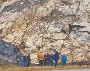
■ Dolomites: The Spectrum – Mechanisms, Models, Reservoir Development
■ Dolomites: The Spectrum – Mechanisms, Models, Reservoir Development
Accuracy and Efficiency on Every Well, Every Time
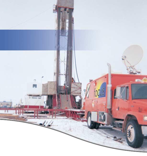
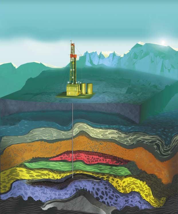
Baker Atlas proudly introduces FOCUS
FOCUS is the latest high-efficiency premium openhole logging system designed for Western Canada. Instruments incorporate improved sensor technology into shorter, lighter toolstrings. The result—data accuracy and precision while logging at speeds up to twice as fast as conventional tools. Faster rig up and rig down reduces time at the wellsite and total cost of operations. FOCUS is customer-friendly—you can access your data with 24-hour viewing whenever and wherever via Baker Atlas' Total RECALLSM leading you to more efficient decisions.
Shorter tools. Faster logging speed. The highest data accuracy and state-of-the-art data delivery. Less time on the well. Faster decisionmaking. Lower total cost of operations.
CSPG OFFICE
#160,540 - 5th Avenue SW
Calgary,Alberta,Canada T2P 0M2
Tel:403-264-5610 Fax:403-264-5898
Email:cspg@cspg.org Web:www.cspg.org
Office hours:Monday to Friday,8:30am to 4:00pm
Business Manager:Tim Howard
Email:tim.howard@cspg.org
Office Manager:Deanna Watkins
Email:deanna.watkins@cspg.org
Communications Manager:Jaimè Croft
Email:jaime.croft@cspg.org
Conventions Manager:Lori Humphrey-Clements
Email:lori@cspg.org
Corporate Relations Manager:Kim MacLean
Email:kim.maclean@cspg.org
EDITORS
Please submit RESERVOIR articles to the CSPG office.Submission deadline is the 23th day of the month,two months prior to issue date. (i.e.,January 23 for the March issue).
To publish an article,the CSPG requires digital copies of the document.Text should be in Microsoft Word format and illustrations should be in TIFF format at 300 dpi.For additional information on manuscript preparation,refer to the Guidelines for Authors published in the CSPG Bulletin or contact the editor.
COORDINATING EDITOR & OPERATIONS
Jaimè Croft
CSPG
Tel:403-264-5610 Fax:403-264-5898
Email:jaime.croft@cspg.org
TECHNICAL EDITOR
Ben McKenzie
GEOCAN Energy Inc.
Tel:403-261-3851
Email:bjmck@telusplanet.net
ADVERTISING
All inquiries regarding advertising and technical specifications should be directed to Kim MacLean.The deadline to reserve advertising space is the 23th day of the month,two months prior to issue date.All advertising artwork should be sent directly to Kim MacLean at the CSPG.
The RESERVOIR is published 11 times per year by the Canadian Society of Petroleum Geologists.This includes a combined issue for the months of July/August.
Advertisements,as well as inserts,mailed with the publication are paid advertisements.No endorsement or sponsorship by the Canadian Society of Petroleum Geologists is implied.
The CSPG Rock Shop is an attractive and affordable way for advertisers to present their services to the CSPG Readership.Spaces are sold at business card sizes (3.5” wide by 2” high) and will eventually fill an entire Rock Shop page. For more information or to book a space please contact Kim MacLean at 403-264-5610,ext.205.
The contents of this publication may not be reproduced either in part or in full without the consent of the publisher.
Design & Layout by McAra Printing
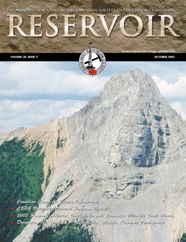
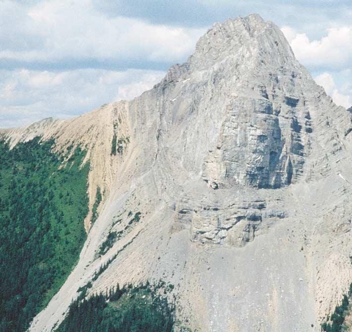
Photo by Gordon C.Hurlburt.
THE CSPG GRATEFULLY ACKNOWLEDGES ITS *CORPORATE MEMBERS:
ABU DHABI OIL CO., LTD. (JAPAN)
ARCHEAN ENERGY LTD.
BURLINGTON RESOURCES CANADA ENERGY LTD.
CALPINE CANADA
CANADIAN FOREST OIL LTD.
CONOCOPHILLIPS CANADA RESOURCES LIMITED
DEVON CANADA CORPORATION
DOMINION EXPLORATION CANADA LTD.
DUVERNAY OIL CORP.
ECL CANADA
EL PASO OIL & GAS CANADA, INC.
HUNT OIL COMPANY OF CANADA, INC.
HUSKY ENERGY
IHS ENERGY
IMPERIAL OIL RESOURCES LIMITED
LARIO OIL & GAS COMPANY MJ SYSTEMS
MURPHY OIL COMPANY LTD.
NCE RESOURCES GROUP INC.
NEXEN INC.
NORTHROCK RESOURCES LTD.
PENN WEST PETROLEUM LTD.
PETRO-CANADA OIL AND GAS
REEVES WIRELINE
SAMSON CANADA
GEOLOGICAL ASSOCIATION OF CANADA CITATION OF FREDERICK J. LONGSTAFFE FOR THE LOGAN
MEDAL
In the quarter-century since he graduated with a McMaster doctorate,Frederick John Longstaffe has built for himself a distinguished academic career in the universities of Alberta and Western Ontario.
In research,Longstaffe has propelled himself to international preeminence as a geochemist by pioneering the use of stable isotopes to improve fundamental understanding of processes operating on and within the Earth.He has addressed such diverse issues as the evolution of ancient crustal rocks,clay-mineral genesis,fluid movement in sedimentary basins,formation and exploitation of heavy oils and oil sands,natural generation of greenhouse gases,plant biomineralization,and paleoclimatic reconstruction.A teacher of high repute,his pedagogical skills have been manifest not only in the university classroom,but also,nationally and internationally,in the lecture circuit and in short courses offered in his profession with almost biannual regularity.A university department head and dean,Longstaffe has also served his professional community loyally and well – as a former President of the Geological Association of Canada,Director of the Earth,Ocean,and Atmospheric Division of the Royal Society of Canada,Chairman of NATO’s Advisory Panel on Advanced Study Institutes,and chairman or member of more than fifty other organizational bodies in the geosciences outside his university.
In their totality,Longstaffe’s accomplishments amount to an academic tour de force richly deserving of recognition at the highest level.
When I was approached to run as Assistant Services Director,they told me it would involve some time,some meetings,and some fun.But they didn’t tell me I’d have to be a writer too!
This is my first year on the CSPG Executive, and as others have mentioned before me,I now have a greater understanding of what it takes to run an organization the size and scope of the CSPG.I am also involved in volunteering with several other charitable and non-charitable organizations,and at the risk of sounding like a broken record,I realize even more that volunteers are the backbone of many of these organizations.
Being involved with the CSPG on the executive isn’t all meetings and business.I was privileged to be invited to the Official Opening of the ATCO Tyrrell Learning Centre at the world-famous Royal Tyrrell Museum on August 19,2003.This is the Alberta Government’s first Legacy project to be completed to commemorate Alberta’s Centennial in 2005.
As we all know,most kids have an interest in dinosaurs from a very young age,and some continue on to become earth scientists, myself being one of them.I still remember as a kid exploring the badlands at Drumheller with my father,looking for fossils.The new ATCO Tyrrell Learning Centre will provide much needed classroom and teaching space to help cultivate budding paleontologists and geologists.The Learning Centre adds more than 16,000 square feet to the museum,which includes a hands-on workshop,a distance-learning studio,and an outdoor interpretive area.It is predicted that an additional 8,000 students each year will have access to various programs at the museum.Just think,if we could get even 1% or 2% of these young people to continue on to study earth science as a career,that could potentially be over 100 new earth scientists a year!
We are all aware of the looming retirement of the baby-boom generation in this business, and the shortage of earth scientists that will follow.Any programs available that encourage young people to study the sciences can only help.You too can do your part by working with our various outreach programs and helping recent earth science graduates with their job searches.I know everyone can remember graduating and all the companies wanting only to hire someone with 2+ years experience.It hasn’t changed! We all know that many times it is “who you know”,contacts,and networking that gets you in the door.If everyone helped even one new earth scientist to find their first job,if would be a great accomplishment.I am presently helping two recent grads with their job search;one has found work as a well-site geologist and the other has been put in contact with a promising potential employer.
And now a message from our sponsor: Check out our new CareerSource link on the CSPG website.Members can post their resumes and access jobs in Petroleum Geology.Employers can search out potential candidates.Visit www.cspg.org.
In closing,I would like to express my thanks to all who have volunteered with the various committees and conventions,and encourage all of you to help out where you can.I look forward to working with the various committees and volunteers during the upcoming year as I assume the position of Services Director.I know everyone is busy in their personal and business lives,but if you could even help out with one event,that would make a difference.At the very least you’ll make lots of new contacts,and you too may have the chance to develop those nontechnical writing skills.
About that broken record,or scratched CD for you younger people,if you are interested in volunteering on any of the committees or for any events,please contact our Volunteer Coordinator,Blythe Lowe,or any member of the CSPG Executive.Even better,if you would like to consider running for an executive position,as elections will be coming up in the fall,please contact Bruce McIntyre,Past President,for details.
Wayne Dwyer Assistant Services Director
OCTOBER LUNCHEON
Exploration Model for CBM
in the Alberta Plains
SPEAKERS
Olwen F.R.Wirth MGV Energy,Inc.
Melany D.Hysert MGV Energy,Inc.
11:30 am Tuesday,October 7,2003
TELUS CONVENTION CENTRE CALGARY, ALBERTA
Please note:
The cut-off date for ticket sales is 1:00 pm,Wednesday,October 1st. Ticket price is $28.00 + GST.
This presentation will focus on the coal zones of the Alberta Plains and some of the factors that have allowed MGV Energy Inc.to develop coalbed methane (CBM) so quickly.We will summarize the major attributes of the target coal zones and MGV’s approach to evaluating their CBM potential.We will also discuss some the important differences between the geologic approach to CBM exploration in Canada before and after 1998.
The first phase of CBM exploration and development in Canada began in the late 1970s and concluded in the early 1990s when most activity took place.During this period,more than 80 wells were drilled in Western Canada of which approximately 50 wells were drilled in the Alberta Plains evaluating Ardley and Mannville coals.No significant commercial production resulted from these initial efforts.
The second phase of Canadian CBM exploration and development began in 1998 and is continuing today.As part of this recent activity,additional coal zones have been tested in the Alberta Plains, including the low-rank Horseshoe Canyon and Belly River Formations.
MGV embarked on CBM exploration in Canada in 1998.To date,MGV’s main focus has been in the Alberta Plains where we have drilled more than 200 wells.In February 2003,MGV was the first company to book CBM reserves in Canada.MGV is currently producing sales gas from coal seams in the Horseshoe Canyon and Belly River
OCTOBER LUNCHEON
Indications for Effective Petroleum Systems in Bowser and Sustut Basins, North-central British Columbia
SPEAKER
K.G.Osadetz
Geological Survey of Canada,Calgary
AUTHORS
L.D.Stasiuk & N.S.F.Wilson
Geological Survey of Canada,Calgary
C.A.Evenchick
Geological Survey of Canada,Pacific
F.Ferri
Ministry of Energy and Mines, British Columbia
11:30 am
Tuesday,October 21,2003
TELUS CONVENTION CENTRE CALGARY, ALBERTA
Please note:
The cut-off date for ticket sales is 1:00 pm,Wednesday,October 15th. Ticket price is $28.00 + GST.
Recent field work in the Bowser and Sustut basins has found ‘live” oil in a breeched Skeena Fold Belt antiform in Jurassic Bowser Lake Group sedimentary rocks of the Intermontane Belt,British Columbia.This oil occurs as oil stains and petroleum fluid inclusions that are generally less than 45 degrees API.Condensate may also be present in some petroleum fluid inclusions.The intergranular porosity of the sample is filled by a pervasive cement that lacks petroleum fluid inclusions,and which probably post-dates the breeching of the structure.Elsewhere,outcropping Bowser Lake Group sediments have preserved intergranular porosity and reservoir potential.Other,anecdotal,
Formations.MGV is testing these formations in new areas as well as evaluating Ardley and Mannville coals.
BIOGRAPHIES
Olwen Wirth,Manager of Geology at MGV Energy Inc.has 20 years of oil and gas experience.She has a B.Sc.in Geology from the University of Alberta.For the past four years she has focused on CBM exploration and development in Western Canada.She began her career as a wellsite geologist, subsequently worked at the Alberta Department of Energy as a reservoir geologist and has worked with various companies in the oil and gas industry in Calgary during the past six years.
Melany Hysert is a geologist with MGV Energy Inc.,and has worked on coalbed methane projects in the Alberta Plains for the past four years.She graduated from the University of Waterloo,in 1997 with a B.Sc. in Earth Science.Her student work terms and contract positions prior to joining MGV Energy Inc.,were at Energy,Mines and Resources Canada;Canmet;Gulf Canada Resources,and PanCanadian Energy.
evidence suggests that natural gas may be seeping from sub-Bowser Lake Group rocks on the shore of Tatogga Lake,in the same general region.This provides direct evidence that there is at least one effective petroleum system in the Bowser and Sustut basins of the Intermontane Belt.The crude oils extracted from these samples have molecular compositions (terpane and sterane biomarkers) that indicate a source in Paleozoic marine carbonate rocks deposited in a meso-haline to hypersaline environment.The source of these oils likely lies in (Devonian to Permian) Stikine Assemblage Paleozoic carbonate strata that underlie Upper Triassic Stuhini Group and Lower to Middle Jurassic Hazelton Group successions on which the Middle to Upper Jurassic Bowser Lake and Upper Cretaceous Sustut successions were deposited.These observations,based on
new organic petrographic data are much more optimistic for oil and gas generation and preservation.However,they illustrate large lateral and stratigraphic variations in thermal maturity that affect petroleum systems and potential reservoirs in ways neither well described or clearly understood. As a result of these new observations,there is a pressing need to revise existing petroleum assessments to capture the impact of reduced risks in plays in both Bowser Lake and Sustut groups and to expand the set of plays to consider the newly recognized potential of underlying successions.There is also a pressing need to act on this new and favourable evidence that an accessible, potential frontier petroleum province,the size of a European country lies effectively unexplored and undeveloped.
BIOGRAPHY
Kirk G.Osadetz is manager of NRCan’s research program into the fuel potential of natural gas hydrates and is the leader of an Energy Research and Development project into the development of improved methods of undiscovered petroleum resource assessment.He contributes to National Energy Board studies of Canadian Energy Supply and the Canadian Gas Potential Committee’s studies of undiscovered natural gas resources.
NOVEMBER LUNCHEON
Triassic Ichthyosaurs from British Columbia - The West Coast of Pangea
SPEAKER
Elizabeth L.Nicholls
Royal Tyrrell Museum of Palaeontology
11:30 am Thursday,November 13,2003
TELUS CONVENTION CENTRE CALGARY, ALBERTA
Please note:
The cut-off date for ticket sales is 1:00 pm,Monday,November 10th. Ticket price is $28.00 + GST.
Ichthyosaurs were the first reptiles to invade the oceans,appearing in the Early Triassic,right after the big extinction at the Permian-Triassic boundary.Of all marine reptiles,they are the most highly adapted to the marine environment. Until recently,most of our information on ichthyosaurs was based on the many well preserved specimens from the Jurassic of Europe.Triassic forms have a much poorer fossil record,and their origin and relationships have remained poorly understood.Recent work in both British Columbia and China are shedding light on some of these problems.
The Royal Tyrrell Museum has been collecting and studying fossil marine reptiles from the Triassic of northeastern British Columbia for the last 12 years.As a result,we can now recognize three distinct faunas of Triassic marine reptiles in the region.
The Early Triassic (Smithian?) fauna is found in the Vega Phroso Member of the Sulphur Mountain Formation,and includes Chaohusaurus and Utatsusaurus. These are the earliest,most primitive ichthyosaurs known,and have many transitional features.Prior to our work in British Columbia,these genera were known only from the Early Triassic of China and Japan.The British Columbia specimens are older than the Asian forms,and raise interesting questions regarding their dispersal.
The Middle Triassic fauna is much more abundant and diverse.This is found in the Whistler and Llama Members of the Sulphur Mountain Formation (AnisianLadinian).In addition to ichthyosaurs,it includes thalattosaurs and sauropterygians. The common ichthyosaur genus is Phalarodon,which is much more advanced than the Early Triassic forms.It was well adapted to the marine environment and,as a result,it has a world-wide distribution around the coast of Pangea.
NOVEMBER LUNCHEON
Geology of the Athabasca Oil Sands:Current Research, New Interpretations,Recent Debate
SPEAKER
Mike Ranger Consultant
AUTHOR Murray Gingras University of Alberta
11:30 am Thursday,November 27,2003
TELUS CONVENTION CENTRE CALGARY, ALBERTA
Please note:
The cut-off date for ticket sales is 1:00 pm,Monday,November 24th. Ticket price is $28.00 + GST.
The last five years have witnessed a surge in Athabasca research fueled by an acceleration in oil sands development,as well as contentious gas production issues.
In south Athabasca,an obligation to demonstrate that gas is isolated from bitumen has generated strong interest in upper McMurray stratigraphy. Indications of the widespread presence of stacked,coarsening-upward (c/u) units,floored by marine mud,have been borne out.The base of a c/u unit is a
The Late Triassic fauna is best known from the Pardonet Formation,although some specimens are found in the underlying Baldonel.This fauna is diverse,with at least five genera of ichthyosaurs being represented.The exceptional abundance of specimens in the Pardonet is consistent with a condensed zone,and a slow sedimentation rate.The two most abundant taxa are the shastasaurid ichthyosaurs Callawayia and Shonisaurus. Shonisaursus is the largest marine reptile on record.A specimen collected by the Tyrrell Museum in 2000 is 23 m long,and larger specimens are known.This puts it well within the range of the larger baleen whales.
These forms became extinct at the end of the Triassic,and were replaced by the widespread genus,Ichthyosaurus.
BIOGRAPHY
Betsy Nicholls received her Ph.D.from the University of Calgary and has been Curator of Marine Reptiles at the Royal Tyrrell Museum since 1990.Her research focuses on marine reptiles from the Triassic and from the Cretaceous Western Interior Seaway.In 2000 she received the Rolex Award for Enterprise for her collection of a giant ichthyosaur from British Columbia.
flooding surface marked by a transgressive surface of erosion.The marine mud deposited on this surface is easily mappable and appears to have been continuous and widespread,acting as a seal for reservoir fluids.The c/u units are shoreface parasequences possibly related to a wave-dominated deltaic system.Their typical facies succession is easily recognised in core, and they also have a distinctive gamma ray signature.Where that signature is anomalous,the c/u parasequences have apparently been eroded.Present debate centres on whether that erosion is autocyclic within a genetic unit,or perhaps is more profound evidence of the presence of unconformities with associated incised valley fills.
The middle McMurray can be subdivided into two dominant facies associations:FA1 constitutes thick bedsets of megarippled sand containing abundant tidal indicators and a marine trace fossil assemblage;FA2 consists of muddy to sandy channel deposits, dominated by IHS point-bar architecture, with a brackish trace fossil fingerprint.The FA2 IHS units always overlie the FA1 megarippled units in a close association,yet they are always separated by an erosional or abrupt contact.This suggests that middle estuary FA2 prograded over outer estuary FA1 into a low accommodation basin,and is not indicative of an incised valley fill.
Current speculation is that the McMurray Formation is a succession of prograding deltaic systems,initially tide-dominated (middle McMurray) due to lateral confinement by the paleotopography of the sub-Cretaceous Unconformity,but evolving to wave- and storm-dominated (upper McMurray) as the basin filled and topography became attenuated.
The Athabasca trapping mechanism is a broad,low amplitude anticline,the eastern arm of which is a structural roll-over caused by dissolution of Devonian salt.North of approximately Twp.89,bitumen extends considerably farther to the east beyond the
salt solution front.Here the trap was probably stratigraphic.Delineating this northeastern "bulge" has driven recent land acquisition strategy.
BIOGRAPHIES
Mike Ranger received his B.Sc.from Concordia University,Montreal,and M.Sc.from Memorial University of Newfoundland in 1979.Employed for eight years at Gulf Canada as an exploration geologist,he worked on the Canadian Arctic Islands,Beaufort Sea,and Athabasca Oil Sands. He received his Ph.D.from the University of Alberta in 1993,and has been an independent consultant in Athabasca Oil Sands since 1990. Mike has also developed sedimentological software which is currently in use worldwide.
Dr.Murray Gingras is an Assistant Professor of Geology at the University of Alberta.Murray's areas of study include ichnology,sedimentology, and stratigraphy.His recent research has focused on developing facies models from modern,marginal-marine,sedimentary environments.His aim is to apply derivative depositional models to the Alberta subsurface. Murray was previously on faculty at the University of New Brunswick.He received his Ph.D.from the University of Alberta in 1999.
Allthetoolsyouneed...
No matter what the job, Divestco provides the leading oil & gas software, services and data to do it right.
Value packages: Need more than one "attachment"? Divestco will customize a value-priced software bundle to meet your needs.
Mapping and Data Tools:
•GeoVista
•MapQ
•OeX
•Express PPDM database
•GeoCAD
• The Rat handheld digitizer
•Mapping Services
Exploration Tools:
•WinPICS
•CrossLOG Suite
•Synthetic Suite
•Envision 3D
•Outrider
•SMAC grid balancing
Exploration Services:
•Seismic data brokerage
•Seismic data loading
•Workstation rental
•Log and dipmeter digitizing
•Geophysical Data Services
Records Management & Services
•Information and Records Management
•DocuServe Corp. Document
Conversion Services
BASIN ANALYSIS DIVISION
Evidence for
a
Basin-scale Unconformity in the Middle Triassic of western Canada
SPEAKER
James Dixon
Geological Survey of Canada,Calgary
12:00 Noon
Monday,October 6,2003
Encana Amphitheatre
2nd Floor, east end of the Calgary Tower Complex 1st St. and 9th Avenue S.E. Calgary, Alberta
The prevailing stratigraphicsedimentological model of the Triassic upper Doig,Halfway,and lower Charlie Lake succession is that of a vertical facies transition from offshore (Doig) through shoreface (Halfway) into sabhka (lower Charlie Lake) deposits,with some tidal inlet deposits associated with the shoreface beds.
Cores and logs throughout the basin indicate there are three distinct stratigraphic settings for the upper Doig to lower Charlie Lake succession.In one setting there is a transitional change from typical thinly interbedded sandstones and shale of the Doig Formation into a thick interval of Halfway sandstone, in turn abruptly overlain by Charlie Lake facies (interbedded dolostone,anhydrite,shale,and minor sandstone).In most of these Halfway successions,an erosionally based interval is present.In the second type of setting,a thin-to-thick Halfway succession rests erosionally on Doig beds,and is abruptly overlain by Charlie Lake facies.In the third setting,lower Charlie Lake beds rest erosionally on Doig facies.
Field- to basin-scale correlations show that major truncation occurs below a widespread erosion surface,corresponding to that seen in core and extrapolated into uncored wells.The best explanation for these stratigraphic relationships is that of a basin-scale unconformity.
Published models have been reexamined and alternative correlations and interpretations show that an
unconformity model can readily explain the stratigraphic relationships seen in the facies models from the Wembley and Peejay areas.
BIOGRAPHY
James Dixon spent several years with Amoco Canada and Petro-Canada before joining the Geological Survey of Canada in 1978.At the Survey,he has worked on the stratigraphy and sedimentology of Triassic to Tertiary strata in the Northwest Territories and northern Yukon,and the Triassic in the subsurface of western Canada.
INFORMATION
BASS Division talks are free.Please bring your lunch.For further information about the division,joining our mailing list,a list of upcoming talks,or if you wish to present a talk or lead a field trip,please contact either Steve Donaldson at 403-645-5534, email:Steve.Donaldson@encana.com or Mark Caplan at 403-691-3843,email: Mark.Caplan@shell.ca or visit our web page at www.cspg.org/basin_analysis.html.
EMERGING PETROLEUM RESOURCES DIVISION
The mandate of the Emerging Petroleum Resources Division (EPRD) is to provide a forum for CSPG members that are engaged in the search,characterization,and evaluation of resources that are commonly regarded as "unconventional" here in Canada.As we look ahead for future petroleum resources,much of the production is expected to come from less conventional plays.Some of the primary emerging resources include coalbed methane,gas and oil shales,gas hydrates and very-low permeability
reservoirs.All of these emerging resources have large resource estimates attached.However,they are currently challenged by technological or economic limitations.
Monthly luncheons are held at noon on the second Wednesday of every month in the ConocoPhillips Auditorium.The ConocoPhillips Auditorium can be found on the +30 level on the west end of the building,at 401 - 9th Avenue SW, Calgary.Speakers for the luncheons are sought from industry,academia,and
research institutions to include topics on coalbed methane,gas hydrates,gas and oil shales,very low permeability reservoirs,and other resources that gain attention in these "unconventional resource" arenas.
INFORMATION
For information on last-minute speakers, changes in date or venue,and the latest information on unconventional petroleum resources,please join the EPRD e-mail distribution list by contacting caddelem@bp.com with title "EPRD list".
INTERNATIONAL DIVISION
Structure,Hydrocarbon
Habitat,and Politics in the Lago Medio Area,Maracaibo Basin,Venezuela
Encana Amphitheatre 2nd Floor, east end of the Calgary Tower Complex 1st St. and 9th Avenue S.E. Calgary, Alberta
Few things happen in Venezuela that don’t have something to do with oil.
The Lago Medio area is situated in the center of the Maracaibo Sub-plate along the Icotea Wrench Fault System.In the Eocene,the Caribbean Plate slid dextrally past the Maracaibo sub-plate and initially created accommodation space for the tide-dominated,deltaic
Misoa Formation.Further local transpression and transtension led to differential uplift and erosion or collapse and preservation.
In the north,hydrocarbons are trapped in the lower Misoa C6/C7 sequences that subcrop against the Mio-Eocene unconformity along the Atico/Icotea transpressive fault/fold system.In the central area the Misoa B6/9 sequences were preserved by differential collapse and hydrocarbons are trapped in subcropping and fault-delineated sequences.In the south,transtensional forces led to the formation of major grabens with local wrench-induced folds.The Miocene Santa Barbara Formation is producing over most of the area.
The failed April,2002 coup and the recent December-January strike/lockout established the control by the Hugo Chavez populist government over PDVSA – the national oil company – and oil policy.Now the Venezuelan opposition is only left with constitutional means in its struggle with the
PALAEONTOLOGY DIVISION
Insights into the Science of Mammalian Biostratigraphy and Late Cretaceous (Lancian) Mammals of the Bighorn Basin,Wyoming
SPEAKER
Michael W.Webb Imperial Oil
7:30 PM
Friday,October 17,2003
Mount Royal College, Room B108 4825 Richard Road SW Calgary, Alberta
Mammalian remains,primarily teeth,are biostratigraphically useful index fossils in terrestrial Cretaceous and Tertiary strata
of western North America.Mammalian teeth are preferentially preserved due to their hardness,are species-specific in most instances,are generally immune from variation due to age and sex,and lend themselves to detailed morphological studies.Using fossil mammals as the primary means of biostratigraphic control in the Cretaceous and Tertiary terrestrial sediments of western North America has led to the creation of North American Land Mammal Ages (NALMAs) that supplement / replace biozones based on European strata and fossils.As a basis for further discussion,tooth morphology and NALMAs will be touched upon.
The Hewett’s Foresight Local Fauna of Wyoming’s Bighorn Basin is latest
government for the control of oil, money,power,and Venezuela.
A series of Maracaibo Basin references can be found at:http://www.cuug.ab.ca/ ~johnstos/maracaibo.html
Acknowledgement: Bob Rieser (geologist) and Hugo Lazarde (project leader),Core Lab,Reservoir Technologies Division,Maracaibo; PDVSA,Maracaibo.
BIOGRAPHY
Since 1972 C.D.(Sam) Johnston has worked on a diverse variety of seismic interpretation and integration projects with Mobil,Gulf, Davitt Consultants,Norcen,and for the last eight years Johnston Seismic Consulting Ltd. He has lived and worked in six countries and worked and/or traveled in over forty.
INFORMATION
There is no charge.Please bring your lunch. Refreshments are provided by EnCana and ECL Canada.For more information or to give a talk in the future,please contact Geoffrey Say at 403 263-0449 or e-mail at g.say@ecqc.com
Cretaceous (Lancian) in age.It is one of only four large collections of Lancian mammals,all of which are found in localities from Alberta,Montana,and Wyoming.Similar to the “type” Lance fauna of eastern Wyoming,the Hewett’s Foresight Local Fauna is rich in multituberculate and marsupial mammals as indicated by the overwhelming abundance of the genera Mesodma and Alphadon .The composition of the multituberculate and eutherian (placental) assemblages suggests northern affinities for the fauna,while the marsupial sample shows important differences from the “type” Lance fauna. The Hewett’s Foresight Local Fauna provides special insight into the status of mammalian populations in the latest Cretaceous of western North America.
INTERNATIONAL PETRODATA LIMITED
The Petrodata Network - The Industry’s “Open” System Solution
IPL’s Corporate Goal
IPL’s Corporate Goal
To ensure The Petrodata File is the most comprehensive and accurate database available.
To ensure The Petrodata File is the most comprehensive and accurate database available.
The Petrodata File Strengths
The Petrodata File Strengths
■ AccuracyOriginal source documents are
■ AccuracyOriginal source documents are
■ Completeness reviewed and utilized by our data technicians and analysts to create the database and ensure the accuracy and completeness of the file.
■ Completeness reviewed and utilized by our data technicians and analysts to create the database and ensure the accuracy and completeness of the file.
■ ConsistencyA network of over 800 regional cross sections are used by our geologists to ensure consistent formation tops for database searches, contour mapping and cross sections.
■ ConsistencyA network of over 800 regional cross sections are used by our geologists to ensure consistent formation tops for database searches, contour mapping and cross sections.
■ Currency Daily updates ensure the most current information.
■ Currency Daily updates ensure the most current information.
IPL Proprietary and Industry Data
IPL Proprietary and Industry Data
■ General Well Data (basic header, DST’s, IP tests, completions, porous intervals, etc.)
■ General Well Data (basic header, DST’s, IP tests, completions, porous intervals, etc.)
■ Formation Tops (correlated by IPL)
■ Formation Tops (correlated by IPL)
■ Fluid Analyses (oil, gas, water)
■ Fluid Analyses (oil, gas, water)
■ Core Analyses
■ Core Analyses
■ Directional Surveys
■ Directional Surveys
■ Grid and Culture
■ Grid and Culture
■ Production/Injection
■ Production/Injection
■ Gas Well AOFP
■ Gas Well AOFP
■ Oil Well BHP
■ Oil Well BHP
■ Reserves
■ Reserves
Vendor Partner Data
Vendor Partner Data
■ Land
■ Land
■ Pipelines/Facilities
■ Pipelines/Facilities
■ Interpreted DST’s
■ Interpreted DST’s
■ Field/Pool/Unit Outlines
■ Field/Pool/Unit Outlines
BIOGRAPHY
Michael Webb received his M.Sc.(Geology) from the University of Alberta for his work on Paleocene mammals from near Drayton Valley,Alberta.He then earned a Ph.D. (Geology) from the University of Wyoming for research in two distinct fields:Late Cretaceous mammals and fluvial sedimentology.Dr.Webb
currently resides in Calgary,working with Imperial Oil on various geological projects based in northern Alberta,the Mackenzie Delta,and offshore eastern Canada.
INFORMATION
This event is jointly presented by the Alberta Palaeontological Society,Mount
STRUCTURAL DIVISION
The Kinematics of Normal Faulting:Lessons from Mapping and Thermochronometry in the Basin and Range Province
SPEAKER Robert J.Brady
Department of Geology and Geophysics,University of Calgary
12:00 Noon, Thursday,October 16,2003
+30 (3rd floor) ConocoPhillips Conference Centre (inside Sunterra Market), Gulf Canada Square, 401 - 9th Avenue SW. Calgary, Alberta
Mapping and thermochronometry from a variety of locations in the Basin and Range Province (southwestern U.S.) has resulted in a new kinematic model of normal faulting.This model suggests that normal fault systems commonly consist of imbricate stacks of faults,in which steeply to moderately dipping
faults merge downward into a basal detachment.This kinematic model is inconsistent with the widely accepted view that any near-horizontal normal faults were rotated to their present orientations by later,cross-cutting normal faults,and slip rates on any given fault rarely exceed 1 mm/yr.Evidence from geological mapping of the South Virgin Mts.,Nevada and Arizona,as well as the Yerington District and Egan Range in Nevada shows that,in all of these areas,extension was initially accommodated through moderately to steeply dipping listric normal faults.As the early faults and fault blocks tilted, secondary faults broke within each fault block,soling into the early faults,rather than cross-cutting them.Thus,some of the early faults became basal detachments,which remained active as they were rotated to dips of less than 20°.Thermochronometry from a number of large-offset fault footwalls suggests that the most significant of these basal detachments have a characteristic slip rate of ~5 mm/yr.
SEDIMENTOLOGY DIVISION
Ichnology of an Ancient, Shallow Marine Embayment: Using Bioturbation Patterns to Enhance
Palaeoenvironmental Reconstruction
SPEAKER
Michelle Spila University of Alberta
12:00 Noon, Monday,October 20,2003
Encana Amphitheatre 2nd Floor, east end of the Calgary Tower Complex 1st St. and 9th Avenue S.E. Calgary, Alberta
The Albian-aged Upper Ben Nevis Formation in the Hibernia Field of the
Royal College and the CSPG Paleontology Division.For information or to present a talk in the future please contact CSPG Paleo Divison Head Philip Benham at 403691-3343 or programs@albertapaleo.org. Visit the APS website for confirmation of event times and upcoming speakers: http://www.albertapaleo.org/
BIOGRAPHY
Robert received his B.Sc.from the University of Calgary and his M.S.and Ph.D. from Caltech.Since receiving his Ph.D.in 1998,he has worked on a variety of projects,including:natural gas exploration in the Canadian cordillera,interpretation of borehole geophysics at the Yucca Mt. proposed nuclear waste repository,seismic hazard studies at Los Alamos National Lab, and the kinematics of strike-slip faults in California.He recently joined the faculty at the University of Calgary,where he is continuing research into the evolution of both strike-slip and extensional structures, and the physical properties of crustal rocks.
INFORMATION
There is no charge.Please bring your lunch.Deserts are provided by Norwest Laboratories.Beverages are provided by HEF Petrophysical.For details or to present a talk in the future,please contact Luc Lalonde at 403-201-4344,email:lklalond@telusplanet.net or Eric Hanson at 403-233-3250,email: Eric.S.Hanson@conocophillips.com
Jeanne d’Arc Basin is an ichnologically complex interval.It consists of highly bioturbated,silty sandstone initially interpreted as lower shoreface deposits. Upon closer examination of the biological component,trace fossil assemblages representing an ecologically stressed community of organisms were identified.These unique assemblages developed in response to changes in
environmental or ecological conditions. Variations in such parameters are common in “stressed” marine systems such as shallow embayments or sounds.
A “stressed” marine system is characterized by fluctuations in environmental/ecological conditions (such as salinity,oxygenation,or sediment influx) outside of the “normal” range of marine parameters.For example, “stressed” marine conditions exist in Norton Sound,Alaska due to fluvial output of the Yukon River.In comparison,modern deposits from Norton Sound are characteristically similar to those of the Upper Ben Nevis.Trace fossil assemblages found in both deposits are characterized by overlapping marine and brackish ichnological signatures.The resulting biogenic fabrics exhibit moderately diverse trace fossil assemblages,nearly complete bioturbation, and domination by one or two ichnogenera.
Recognition of “stressed” trace fossil assemblages in the upper Ben Nevis Formation is extremely important in palaeoenvironmental and palaeotectonic analysis.Prior to this study,deposition in the Hibernia area during Albian time was thought to have taken place in relatively open marine and tectonically stable conditions.As a result of this study,it is now believed that deposition took place under restricted,shallow marine conditions created by syn-depositional faulting, subsidence,and rollover.
INFORMATION
Talks are free – don’t forget to bring your lunch!
For more information about this talk,or about presenting a talk,please call Scott Leroux at (403) 645-2419,(email:Scott.Leroux@EnCana.com).
THE ABC's OF STARTING AN OIL & GAS COMPANY
November 28, 2003
CANADIAN CENTRE FOR ENERGY INFORMATION
All about energy,all in one place
The Canadian Centre for Energy Information is all about energy—the energy that is vital for Canada’s present and future prosperity.
Whether you’re a geologist,policy-maker, investor,educator or member of the public,we are committed to becoming your link to energy information and educational materials that are credible,comprehensive and convenient to access by means of our Web portal,information centres and printed materials.Through these resources,we provide up-to-date information,news and commentary about the Canadian energy sector from the mainstays of oil,natural gas,coal,thermal and hydropower through to nuclear,solar and other alternative sources of energy.
With more than 50 live news feeds,live energy market and commodity price feeds, encyclopedia level information on all energy sources and a variety of energy education resources,the Centre for Energy portal (www.centreforenergy.com),brings you all kinds of information — all in one place.
PARTNERSHIP PROGRAM
As a relatively new organization,the Centre for Energy has the potential through our partners program to become a pivotal communications medium that fosters knowledge and ensures those who can most affect the future of Canada’s energy sector are well informed.
Partners benefit from having a wellinformed public and key stakeholders who
not only make better business decisions related to energy,but who also invest in energy,choose careers in energy and even use energy more wisely.
Following is a brief description of the many ways in which your organization can benefit from a partnership with the Centre for Energy:
• Funding partners invest in a five-year funding commitment to the Centre for Energy for energy sector and regionspecific content development,energy education resources development,satellite venue development and Centre for Energy operations.
• Content partners are leading providers of energy-related information,articles,news and commentary regarding all facets of the energy sector.
• Traffic referral partners are energyrelated Web sites,publications,or associations that link to centreforenergy.com.Traffic referral partners can enhance their site by including the Centre for Energy banner,buttons or test links to centreforenergy.com content and resources.
• Marketing and branding partners align complementary products and services with the Centre for Energy to extend each organization’s reach and relationships with key audiences.
• Distribution partners provide new avenues for users to access energy-related information from the Centre for Energy.
The Centre for Energy is currently establishing partnership agreements with a number of organizations,including associations,educational institutions, government and environmental groups.For more information about becoming a partner, please e-mail partner@centreforenergy.com or call 403-263-7722.
ADVISORS
Centre for Energy advisors play a key role in ensuring that published information is factual, supported by research and reviewed by reputable,independent sources.Advisors are mid- to senior-level experts from the Canadian energy sector,educators,and others who review Centre for Energy content and provide advice regarding additional resources.For more information about becoming an advisor, please e-mail advisor@centreforenergy.com or call 403-263-7722.
STAY INFORMED
Individuals may also keep in touch with the Centre for Energy by e-mail.Whether you’re a member of an organization or an interested individual who wants to stay current with energy events,news and views,the Centre for Energy will send you timely e-mails that alert you to new developments on the portal or within the organization.There is no cost for this service —simply complete the online sign-up form at www.centreforenergy.com
JACK PORTERVIGNETTES OF CANADIAN PETROLEUM GEOLOGY
Continued from the September Reservoir
The Extraordinary Odyssey of R.
G. McConnell
Some 16 years following the Fort Nelson tragedy,Governor George Simpson had instructed Hudson’s Bay Clerk John Hutchinson to establish a post on the upper Liard River.Hutchinson,in the company of four voyageurs,set out from Fort Simpson in late June,1829 in their North canoe,which included,as well,90 pound packets of trade goods,staple food,and equipment.Arriving at the forks of the Liard and its East Branch (Fort Nelson River),the party encountered local natives who dissuaded them from continuing up the Liard proper.They expressed foreboding accounts of the paucity of wild life and the impenetrability of the river.It was their subtle ploy,albeit overstated,to convince Hutchinson to locate a trading post within their environs.Heeding their advice,the Hudson Bay men proceeded up the East Branch and during the first day,
after travelling approximately 30 miles, observed the derelict remains of the former North West Company’s Fort Nelson.After ascending the river for some 120 miles farther,they arrived at its confluence with the Prophet and Muskwa tributaries.It was near here that they erected a post which was named Fort Halkett.From its inception,the new post’s intake in furs was at best marginal, owing to inclement winter weather and the natives preoccupation with subsisting on the limited game that could be procured.The rabbit population had seriously declined, which scarcity had impacted on its predators. After a mere three years of occupancy,Chief Factor Edward Smith of Fort Simpson,after consulting with Governor Simpson,ordered, in 1832,that the post be abandoned and moreover that a new Fort Halkett be constructed the same year at a location on the upper Liard in the region of the mountains.Interestingly,old Fort Halkett was reestablished by the Hudson’s Bay Company
in 1865 (Ref.:1953,Karamanski,Theodore J.; Fur Trade and Exploration - Opening the Far Northwest 1821 -1852,Univ.of British Columbia Press,pp.89,90&112).
Fort Liard,erected in 1804 by the North West Company,was the first fur trading post on the Liard River.Simon Fraser is reported to have been there the same year followed by his colleague,George Keith of the same company.A second post is believed to have been built by the Nor’Westers between Fort Liard and Fort Simpson but no record remains of its precise site (Ref.:1900,Bryce; The remarkable Story of the Hudson’s Bay Company.Pub.,Sampson Low,Marston and Company,p.392).Undoubtedly,it was shortlived and conceivably its position may have been where the South Nahanni River debouches into the Liard.
George Dawson submitted a summary report to his director,Alfred Selwyn,after he and his assistant,James McEvoy,completed their reconnaissance survey in 1887 of the Dease,upper Liard,Frances,Findlayson,Pelly, and Yukon (Lewes) Rivers.He,as supervisor of the Yukon Exploring Expedition of 18871888,was to receive Richard McConnell’s preliminary report of the lower part of the Liard River and return with it to Ottawa. Unfortunately,McConnell had sent his report via the Hudson’s Bay winter packet. Owning to a delay in expediting the packet, his summary report was not received by Dawson.Notwithstanding,the latter submitted to the director two letters he had received from McConnell,dated July 27,1887. An extract from his first letter succinctly reveals the fortitude with which he and his men endured the most dangerous course of the upper Liard River.McConnell relates: “Between the Little Cañon (Canyon) and forty miles below the Devil’s Portage it falls over 1,000 feet,and as forty miles of this is good water you may imagine the state of the rest.It would be bad enough if it had room to flow,but it is penned in by cañons (canyons),often less than 150 feet wide, every few miles,and then whirls and boils in an incredible manner.We worked our way by sheer muscle,carrying both boat and stuff
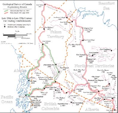
Figure 1. Drainage Basins of the Mackenzie and Yukon Rivers.
through forests and over high hills.My men turned out well and worked without a grumble.As for myself,I have hardly a stitch of clothes left,as they were torn to pieces and left hanging on the brambles and roots along the many portages.” (Ref.:Selwyn, Alfred,R.C.,Summary Report of the Operations of the Geological Survey for the Years 1887 and 1888.pp.12A,13A).
The Hudson’s Bay Company’s exploration of the upper Liard River and its tributaries commenced following its amalgamation with the North West Company in 1821.
John W.McLeod,a Hudson’s Bay clerk,and his party left Fort Simpson in 1823 and ascended the Liard to its confluence with the South Nahanni River.After entering the latter some distance,he and his party abandoned their canoe and,after striking overland on foot across nine mountain ranges,they arrived at a region of detached, low-relief mountains.No natives were encountered during the expedition’s advance.On their return,however,they met with a camp of Nahannis whom they agreed to meet again with the next spring (Morton,Arthur S.,1939,A History of the Canadian West to 1870 - 71,Pub.Nelson, pp.705,706).McLeod’s party probably traversed the southern extremities of the Mackenzie and Selwyn Mountains and entered the Hyland Plateau region.
Prior to the union of the two companies,the North West Company had operated two trading posts along the drainage system of the Liard River.They had been served by their principal post,referred by the Nor’Westers as Folks of the Mackenzie (renamed Fort Simpson after merger).Fort Liard was erected in 1805 and was located on the lower Liard River near its junction with the Petitot River.The ill-fated,short-lived Fort Nelson,built in 1807,was located on the Fort Nelson (originally named East branch of Liard) not too far from that tributary’s meeting with the Liard.The inhospitable nature attributed to the upper Liard and its indigenous tribes by local natives,either real or contrived,was sufficient to slow the Nor’Westers incursions into this hinterland.
The Dease River was discovered by John McLeod of the Hudson’s Bay Company on August 31,1831.This was the same McLeod who,eight years earlier,had led a company party in reconnoitering the lower reaches of the South Nahanni River.
On June 28,1831,McLeod embarked from Fort Simpson accompanied by six voyageurs and two native hunters (Karamanski, Theodore J.,1953;Fur Trade and Exploration - Opening the Far Northwest 1821-1852, Pub.,U.of B.C.Press,p.94).McLeod and his party reached Fort Liard,a distance of 160 miles of river travel from Fort Simpson, within six days of departure.This lower segment of the Liard presented no serious obstacles for navigation.During the week McLeod spent visiting Murdock McPherson, the post’s clerk,he attempted to extract information from the local natives as to what he could expect during the course of his
ascent.The local natives told of the impending perils that the upstream river would impose on McLeod and his party.He was inclined to dismiss,for the most part, their ominous predictions and concluded that such remarks were motivated by their self-serving interests to preclude the inclusion of additional native groups engaged in the trafficking in furs.
After departing from Fort Liard and proceeding upriver,McLeod began to realize that the dire predictions made by the
Continued on Page 22 ...
natives at Fort Liard were not to be belied. What lay ahead proved to be a voyageur’s nightmare.Hardly a day passed that the crew was unable at some point to paddle upstream.The subsequent naming of the treacherous stretches of the Liard:“Hell’s Gate”,“Rapids of the Drowned”,“Grand Canyon”,“Devil’s Rapids” and “Whirlpool Canyon” attests to the hardships met by those would-be navigators.
On reaching the outflow of the Dease River into the Liard,McLeod and his party purposely diverted their course into this major southwest tributary for several miles, only to be confronted by a narrow canyon which had constricted the river’s flow into a stretch of boiling rapids.Thwarted by this obstacle,McLeod and his party returned to the Liard to continue their search for its source.During their subsequent ascent, McLeod’s mistaken judgement convinced him to veer north into what he had supposed,up to then,was the main channel of the Liard.In actuality,he had diverted his course to an important northern tributary of the Liard,
later to be named Frances River.They continued up this tributary to its outflow from a large lake which McLeod named Simpson’s Lake after Governor George Simpson.They had hoped to encounter natives on crossing this lake,but instead found evidence of their presence at an abandoned fish camp where a cache was discovered. McLeod,in investigating its contents for European-produced trade articles,found none.As a surreptitious trading gesture, McLeod removed three beaver pelts from the cache and in their place substituted knives and fire steel,as well as other manufactured trade goods (Ibid.,p.109).Prior to their departure, McLeod recorded their presence by blazing a large pine tree,located on a island in Simpson’s Lake on which he carved his initials, date of arrival,number of men in his party,and departure date from Fort Simpson.At the prompting of his party members,the island, bearing his inscription,was given the name: “McLeod Island” (Ibid.,p.110).
The return trip to Fort Simpson,which took 16 days,was unfortunately marred by a tragic
episode which occurred at Portage Brule Rapids.In order to reduce the risk in running these rapids in their 25-foot,300-pound birch-bark North canoe,an additional load of no more than four men was allowed:a bowman,sternman,and two paddlers. Consequently,McLeod,in the company of two voyageurs and the two natives,proceeded along the portage trail.They apprehensibly shouted words of encouragement to the four voyageurs as they maneuvered their canoe through the rapids when,unavoidably,it collided with a partially submerged rock ledge which severed the canoe in three parts.Two of the voyageurs disappeared beneath the cascading water while the other two,clinging to fragments of the dismembered canoe, fortuitously made it safely to shore.McLeod and his remaining crew were faced with the dilemma of how to construct a replacement canoe,since their axe and other necessary items were lost in the river.With only the use of a crooked knife,they managed to fashion a makeshift canoe,which served to convey the remaining seven of them safely to Fort Simpson.They arrived there on September 9,
Continued on Page 30 ...
March 19 - 20, 2004
Raddison Hotel & Conference Centre
Canmore, Alberta
With the current transition from conventional to nonconventional oil and gas production there is often an associated increased impact on water resources. Water requirements for enhanced oil recovery can lead to potential conflict between energy development projects and other users over limited supplies of usable water resources. In addition, the handling and disposal of co-produced waters can have associated environmental impacts. With increasing reliance on non-conventional hydrocarbons there will be growing debate over the balancing of society’s needs for both affordable energy and adequate water supply. The Hydrogeology Division of the Canadian Society of Petroleum Geologists is presenting a two-day conference in Canmore, Alberta to examine issues of water use in energy development. The intention of the conference is to present the current state of technical knowledge as well as to create an atmosphere where discussions amongst the participants are encouraged to facilitate the sharing of ideas, problems and solutions across disciplines. The meeting will have three half-day focus sessions with presentations by invited specialists, in addition to a delegate’s poster session. A wrap up round-table discussion will follow each session. Conference registration is limited to 250 delegates.
SESSIONS:
Water resources for petroleum exploration and production (Dr. Kevin Parks, Alberta Geological Survey - Chair); Resources for waterfloods, steam generation, etc.
Resource Conflict (Dave McGee, Alberta Environment - Chair): Industrial impacts on surface and shallow groundwater resources.
Handling and disposal of produced water (Dr. Ian Hutcheon, University of Calgary - Chair); Coalbed Methane waters, co-produced freshwaters from shallow gas, SAGD produced water, treatment and compatibility, disposal of acid gases into aquifers, etc.
KEYNOTE SPEAKERS:
• Dr. Marios Sophocleous, Kansas Geological Survey
• Dr. Bill Gunter, Alberta Research Council
• Dr. David Percy, Dean of Law, University of Alberta
CALL FOR POSTERS:
Oral talks will be by invitation only. However delegates are welcome to submit abstracts for poster presentations pertaining to the subject of the 3 main themes of the conference. Deadline for abstract submission is December 10, 2003.
For more information, registration and electronic submission of abstracts go to www.cspg.org or contact the CSPG office at 264-5610
CONFERENCE ORGANIZING COMMITTEE:
Stephen Grasby, Geological Survey of Canada, Natural Resources Canada
The CSPG University Outreach Committee was formed in 2002 to augment links between the CSPG and Canadian university earth science departments.We aim to help attract university geology students to the petroleum industry or related government and academic positions,and ultimately to encourage them to join the CSPG.
The University Outreach Committee is active in four main areas:
1.University Lecture Tours
CSPG members present lectures focused on geological applications in industry or academic settings.The lectures are organized as week-long tours of several universities,and include time at each school for the speaker to meet and talk with students and faculty.
There were three very successful tours conducted during the 2002/2003 school year,
and we have plans in place for another five during the fall term of 2003.Our goal is to have at least one speaker visit every geology department in the country,every year.
2.Participation in University Conferences
University Outreach takes an active role each year in the Western Inter-University Geological Conference and the Atlantic Universities Geological Conference,by supplying financial sponsorship,and presenting awards for best student presentations.We also give technical talks,judge student presentations,and set up a CSPG booth to promote active discussion with the students. In 2002,the CSPG sponsored a short course at the WIUGC.
The Outreach Committee is also supporting the efforts of graduate students at Ontario universities to launch an annual conference.
3.Promoting Student Membership
The traditional student membership structure was not promoting active and widespread student participation,so we have created a new Student Chapter structure. Student geology clubs at each university will become affiliates of the Society,and geology club members will automatically become CSPG Student Chapter members.Student Chapters will give us a vehicle to promote CSPG activities and awards directly to the students,and to make them aware of the CSPG and the petroleum industry while they are still in school.
The Executive and ETF boards have given us the green light to put the Student Chapters into place this fall.
4.Corporate Participation
University Outreach will provide a connection between industry and earth science departments.We will facilitate the donation of educational materials to the schools;to date, donations of core from two corporate sponsors have been arranged.We also want
to sponsor research links,connecting industry projects with university researchers.
There are a number of other initiatives that have been linked to the University Outreach Committee,all under the supervision of the Educational Trust Fund.These programs are run by independent committees,but are listed here to provide a complete overview of the CSPG’s involvement with the university community.
•Student-Industry Field Trip (SIFT)
A third-year student from each earth science department is invited to attend a two-week industry training session in Calgary,which includes lectures, competitions,and field trips.
•Regional Graduate / Undergraduate Scholarships
Awarded annually to promote advanced education and research in fields of geology having application to the petroleum industry.Three graduate and three undergraduate awards are made each year.
•Undergraduate Student Awards
Awarded annually to one undergraduate student in each Canadian university earth science department
•Graduate Student Thesis Awards
Two prizes (Ph.D.and M.Sc.) awarded annually for Canadian graduate theses making the most significant contribution to sedimentary and/or petroleum geology
For more information on University Outreach, please see the CSPG website,or contact:
Brad Hayes
(Petrel Robertson Consulting) – Chair
Selena Billesberger (Murphy) – Speaker Tours
Kris Jewett (Encana) – Student Chapters
Jennifer Unterschutz (Imperial) – University Conferences
George Ardies (Encana) – Corporate Participation
CSPG VOLUNTEER COORDINATOR
If you are looking for a volunteer opportunity within the CSPG,Blythe will be happy to help you find your volunteer niche.
She can also provide information about any of the Society’s numerous committees if you require it.
Blythe will also assist with finding replacements for current committee volunteers who need a change and help them to find different volunteer opportunities in the Society,if desired.
Blythe Lowe can be reached in Calgary at 403-290-3516. Give her a call!
2003 HONORARY ADDRESS: EARTHQUAKES AND TSUNAMIS: WHEN THE EARTH MOVES
aOctober 29th,2003
The CSPG Educational Trust Fund, CSEG,and APEGGA are excited to present ‘Earthquakes and Tsunamis: When the Earth Moves ’ as the 2003 Honorary Address.
This year we have two very exciting speakers; Dr.Eddie Bernard,Ph.D,is the Director of the Pacific Marine Environmental Laboratory of the National Oceanic and Atmospheric Administration (NOAA) in Seattle.Among many accolades,he is a noted oceanographer and an expert on tsunamis. Dr.Garry Rogers,Ph.D.,is a Research Scientist at the Geological Survey of Canada (GSC) and is a renowned lecturer and expert on earthquakes in western Canada.Together, they will present the fascinating tsunami phenomenon – everything from the
earthquakes that trigger them,to the destruction that they cause.
The main Address will be given Wednesday, October 29th at the Jubilee Auditorium. Tickets will be sold through Ticketmaster (777-0000 or www.ticketmaster.ca) as of August 15th.Be sure to look for the poster insert in your October Reservoir for additional information and in the near future,visit either www.cspg.org or www.cseg.ca for details.
In addition to the evening presentation,the CSEG,CSPG,and APEGGA,together with numerous corporate sponsors,are putting on an afternoon performance for 2,0003,000 school children.Students from both Public and Catholic schools will be invited to attend the afternoon show at no cost to them.At a time when education budgets are being cut and field trips are at a
ROCK SHOP
517-3132
minimum,the corporate world is able to contribute to the responsibility of extracurricular education and we are glad to be able to share Dr.Bernard’s and Dr.Rogers’ knowledge with students.
For more information on this year’s Honorary Address ‘Earthquakes and Tsunamis: When the Earth Moves’ , please contact the following people:
For general information,contact either Brett Wrathall (bwrathall@krangenergy.com) or Laraine Kish (lkish@ultimatrust.com).For sponsorship opportunities,contact Kim MacLean (kim.maclean@cspg.org,264-5610 ext 205).
See you there!!
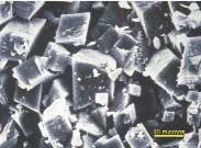
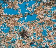
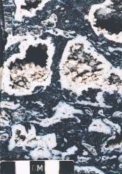
DOLOMITES: THE SPECTRUM – MECHANISMS, MODELS, RESERVOIR DEVELOPMENT
Announcing a New CSPG Initiative
A 3-day Seminar and Core Conference
January 13-15,2004
HONORARY CHAIR: Eric Mountjoy
TECHNICAL CHAIRS: Graham Davies and Jeff Packard
In Alberta and British Columbia alone,between 90 and 95% (62 TCF) of initial established reserves (IER) of gas and between 75 and 80% (7.2 BBbls) IER of crude oil trapped in carbonate reservoirs are in dolomite (Dec.1997 data,GRD calc.) Globally,dolomite (or dolostone) reservoirs are major contributors to world petroleum reserves.Dolomite also is host for nearly half of the world’s lead and zinc in Mississippi Valley Type (MVT) deposits,and for other economic minerals.Because of this economic impact,dolomites (rock and mineral) have been the subject of a huge amount of research beginning more than 200 years ago when the mineral was first described (1791) by the French geologist Deodat de Dolomieu… but still they remain an enigma! There probably are more questions,uncertainties,and unknowns about dolomites than most sedimentary rocks.Where lies the ‘truth’,what ‘models’ should we adopt,follow or discard,what is ‘new’,and where are we going in understanding this ‘holey’ rock?
The objectives of this combined one-day seminar and two-day core conference are to review the spectrum of dolomite types,hear current views by internationally recognized researchers,and to look ‘hands on’ at a wide range of western Canadian core examples.It is hoped that the end product will be a clearer view of the origin of dolomite and it’s contribution to reservoir development.
THE ONE-DAY SEMINAR
Invited speakers for the seminar are:
Lawrence Hardie,The Johns Hopkins University (keynote*)
Dave Morrow,Geological Survey of Canada
Taury Smith,New York State Reservoir Group
Fiona Whittaker,University of Bristol
Noel James and Kurtis Keyser,Queen’s University
Jack Wendte,Geological Survey of Canada
*2002/3 Pettijohn Medallist
THE CORE CONFERENCE
It is anticipated that there will be 25 core/sample/poster presentations of dolomite case histories,ranging from the Cambrian Cathedral Fm.to the Triassic Baldonnel Fm.Cores from the Ordovician (Red River) and Silurian (Interlake) will be on display and the Devonian and Mississippian will be thoroughly represented.The organizers have attempted to solicit examples that encompass the spectrum of dolomitization models.All presentations will remain available for viewing for the two days of the conference.
DOCUMENTATION
CD with seminar abstracts and illustrated extended abstracts of core presentations.
LOCATION AND DATES
Seminar:January 13,2004,downtown Calgary,location TBA Core Conference:January 14 – 15,2004,AEUB Core Research Centre
REGISTRATION
Online only,available December 1st,2003,for both Seminar and Core Conference,or either event:Cap 250 registrants.Fees:TBA
Milk River Medicine Hat
Second White Specks
This is a one-day workshop on the geology and reservoir characteristics of these shallow, low-permeability, gas-bearing formations in southern Alberta and Saskatchewan. This popular and well-reviewed course has been updated to include recent developments in shallow gas exploration.
Topics include:
Stratigraphy, facies, structure, lithological properties and log characteristics of each formation.
Shallow gas production issues, including reserve estimation. Descriptions of all existing play trends.
32 cores from Alberta and Saskatchewan will be shown. There is a 250 page book of course notes containing many unpublished maps and sections
Date and location: October 17th, 2003 at the EUB core facility, Calgary. Course Fee: $650
Contact: Shaun O'Connell, Belfield Resources Inc. ph: 403-246-5069; email: belfield@shaw.ca
Hyder Farhat Sperry - Sun Drilling Services Of Canada Regular
Anthony G.GrimisonRegular
David GuedoKetch Resources Ltd.Regular
John HankoRyder Scott CompanyRegular
Jason HinesRegular
Dawn C.HodginsExxonMobil Canada Ltd.Regular
Fotina A.KaravasExxonMobil Canada Ltd.Regular
Olga V.KostenkoRegular
Aaron R.LeBlancDevon Canada CorporationRegular
Randy E.MaksymowichVirtus Energy Ltd.Regular
Dean J.MalhiotMalhiot Geoservices Ltd.Regular
Les D.McMillanRegular
Abiodun
Omotola OgunjobiDegeconek Nigeria LimitedRegular
Wasim A.ParachaRegular
R.Scott ParkerExxonMobil Production Co.Regular
Karen M.PhillipsExxonMobil Canada Ltd.Regular
Rachelle K.PinnowEnerplus Global Energy Management CompanyRegular
Marianne Rauch-DaviesFusion GeophysicalRegular
J.Cameron SchmidtEncana CorporationRegular
Brian W.TsangEBA Engineering Consultants Ltd.Regular
Patrick J.TwaChinook Consulting 2003 Ltd.Regular
Esther C.VisserDeer Creek Energy Ltd.Regular
Xiaoli WangRegular
Lynn T.ReichUniversity Of AlbertaStudent
Oliver J.SchatzMcGill UniversityStudent
Kristian WhiteheadUniversity Of VictoriaStudent
Duvernay Oil CorporationCorporate
Chief Factor Edward Smith,who was in charge of the Mackenzie District and headquartered at Fort Simpson,was obviously impressed with McLeod’s journey into the remote region of the upper Liard River and especially with its potential for increasing profits from fur trafficking.Accordingly,Edward,after consulting with Governor Simpson,was given permission in 1832 to close the unprofitable Fort Halkett,located on the upper reaches of the Fort Nelson River (East branch of Liard). In its place a new Fort Halkett was constructed the same year,at a location on the north bank of the upper Liard where it receives the discharge from the Smith River.
Richard McConnell’s arrival at Fort Simpson occurred 56 years and one month to the day after John McLeod had arrived at the same post following his exploration of the upper Liard River.Both men and their parties had endured the travails resulting,primarily,from the necessity of having to cross an abnormal
number of portages,which condition had been exacerbated by the summer’s swollen river.Coincidentally,both had to improvise unconventional craft to extricate themselves and their crews from their threatening predicaments;McConnell with his canvas boat and McLeod with his stopgap canoe. The leadership qualities endowed in both explorers,combined with the dexterities of their respective boatmen and their native hunters and guides comprised the amalgam, without which neither McLeod’s nor McConnell’s accomplishments may have come to fruition.
Within several days after his arrival at Fort Simpson,McConnell took passage on the Hudson’s Bay Company’s steamer “Wrigley”, which was bound for Fort Smith situated on the Slave River.She had been constructed there in 1885 below the 16 mile portage.This location enabled her to be the first steampowered vessel to access the lower Slave River,Great Slave Lake,and the Mackenzie River (Innis,Harold A.,RP 1973,The Fur Trade in Canada,Univ.of Toronto Press,p.345).She,
subsequently,made annual journeys down the Mackenzie to Fort McPherson by way of Peel River.Her christening was in honour of Joseph Wrigley,a former Trade Commissioner for the Hudson’s Bay Company.
With some six weeks remaining of his field season,Richard McConnell elected to obtain winter lodgings in the region rather than return to Ottawa.It would afford him the opportunity of conducting overland surveys during the winter months.Following his arrival in the “Wrigley” at Fort Providence,he made an overture to a Mr.Reid,the Hudson’s Bay Company’s officer in charge,if he could be quartered there for the forthcoming winter. After receiving confirmation from J.S.Camsell, the chief factor for the MacKenzie District,as well as permission from Survey Director Alfred Selwyn,his accommodation was assured.As an aside,Charles Camsell,a noteworthy geologist with the Geological Survey of Canada during the period 1904 - 1920 and who was born at Fort Liard in 1876,was the son of J.S.Camsell.