■ Fifteenth Annual CSPG 10Km Road Race, September 10, 2003
■ ConocoPhillips Glen Ruby Memorial Scholarships in Geosciences
■ 2004 CSPG Fall / Winter Conference, Dolomites: The Spectrum – Mechanisms,Models, Reservoir Development
CSPG OFFICE
#160,540 - 5th Avenue SW
Calgary,Alberta,Canada T2P 0M2
Tel:403-264-5610 Fax:403-264-5898
Email:cspg@cspg.org Web:www.cspg.org
Office hours:Monday to Friday,8:30am to 4:00pm
Business Manager:Tim Howard
Email:tim.howard@cspg.org
Office Manager:Deanna Watkins
Email:deanna.watkins@cspg.org
Communications Manager:Jaimè Croft
Email:jaime.croft@cspg.org
Conventions Manager:Lori Humphrey-Clements
Email:lori@cspg.org
Corporate Relations Manager:Kim MacLean
Email:kim.maclean@cspg.org
EDITORS
Please submit RESERVOIR articles to the CSPG office.Submission deadline is the 23th day of the month,two months prior to issue date. (i.e.,January 23 for the March issue).
To publish an article,the CSPG requires digital copies of the document.Text should be in Microsoft Word format and illustrations should be in TIFF format at 300 dpi.For additional information on manuscript preparation,refer to the Guidelines for Authors published in the CSPG Bulletin or contact the editor.
COORDINATING EDITOR & OPERATIONS
Jaimè Croft
CSPG
Tel:403-264-5610 Fax:403-264-5898
Email:jaime.croft@cspg.org
TECHNICAL EDITOR
Ben McKenzie
GEOCAN Energy Inc.
Tel:403-261-3851
Email:bjmck@telusplanet.net
ADVERTISING
All inquiries regarding advertising and technical specifications should be directed to Kim MacLean.The deadline to reserve advertising space is the 23th day of the month,two months prior to issue date.All advertising artwork should be sent directly to Kim MacLean at the CSPG.
The RESERVOIR is published 11 times per year by the Canadian Society of Petroleum Geologists.This includes a combined issue for the months of July/August.
Advertisements,as well as inserts,mailed with the publication are paid advertisements.No endorsement or sponsorship by the Canadian Society of Petroleum Geologists is implied.
The CSPG Rock Shop is an attractive and affordable way for advertisers to present their services to the CSPG Readership.Spaces are sold at business card sizes (3.5” wide by 2” high) and will eventually fill an entire Rock Shop page. For more information or to book a space please contact Kim MacLean at 403-264-5610,ext.205.
The contents of this publication may not be reproduced either in part or in full without the consent of the publisher.
Design & Layout by McAra Printing
THE CSPG GRATEFULLY ACKNOWLEDGES ITS *CORPORATE MEMBERS:
ABU DHABI OIL CO., LTD. (JAPAN)
ARCHEAN ENERGY LTD.
BURLINGTON RESOURCES CANADA ENERGY LTD.
CALPINE CANADA
CANADIAN FOREST OIL LTD.
CONOCOPHILLIPS CANADA RESOURCES LIMITED
DEVON CANADA CORPORATION
DOMINION EXPLORATION CANADA LTD.
DUVERNAY OIL CORP.
ECL CANADA
EL PASO OIL & GAS CANADA, INC.
HUNT OIL COMPANY OF CANADA, INC.
HUSKY ENERGY
IHS ENERGY
IMPERIAL OIL RESOURCES LIMITED
LARIO OIL & GAS COMPANY
MJ SYSTEMS
MURPHY OIL COMPANY LTD.
NCE RESOURCES GROUP INC.
NEXEN INC.
NORTHROCK RESOURCES LTD.
PENN WEST PETROLEUM LTD.
PETRO-CANADA OIL AND GAS
REEVES WIRELINE
SAMSON CANADA
SHELL CANADA LIMITED
SPROULE ASSOCIATES LIMITED
SUNCOR ENERGY INC.
TALISMAN ENERGY INC.
TOTAL E&P CANADA LIMITED UPTON RESOURCES
CANADIAN SOCIETY OF PETROLEUM GEOLOGISTS 2004 EXECUTIVE COMMITTEE
The Canadian Society of Petroleum Geologists takes great pleasure in announcing the Executive Committee for 2004.
PRESIDENT Craig Lamb,Husky Energy Inc.
VICE PRESIDENT Jeff Packard,Burlington Resources Canada Energy Inc.
PAST PRESIDENT John Hogg,Encana Corporation
FINANCE DIRECTOR Pauline Chung,Burlington Resources Canada Energy Inc.
ASSISTANT FINANCE DIRECTOR Al Schink,Berland Exploration Ltd.
PROGRAM DIRECTOR Lavern Stasiuk,Geological Survey of Canada - Calgary
ASSISTANT PROGRAM DIRECTOR Doug Hamilton,Encana Corporation
SERVICES DIRECTOR Wayne Dwyer,ConocoPhillips Canada Ltd.
ASSISTANT SERVICES DIRECTOR Astrid Arts,ConocoPhillips Canada Ltd.
COMMUNICATIONS DIRECTOR Ashton Embry,Geological Survey of Canada - Calgary
The 2004 Executive Committee will take office following the Annual General Meeting at the Telus Convention Centre on Thursday,January 8th,2004.Photos and biographies of the 2004 Executive will be included in the December Reservoir.
If you require further information please contact: Tim Howard,Business Manager,Canadian Society of Petroleum Geologists #160,540-5th Avenue S.W.,Calgary,Alberta,T2P 0M2
After three years on the CSPG Executive the time has come for me to make my final commentary.
The Society is in good shape from a financial standpoint,however,I feel that we are rapidly approaching a membership crisis as many of us approach retirement age.The membership survey that was carried out in October of 2002 showed that the average CSPG member is between 45-50 years of age.These members will retire within the next ten years.These statistics are not unique to the CSPG –these trends are global.
When I graduated from university in the late 1970s,multinationals and large independent exploration companies hired recent graduates straight out of university. They assumed the responsibility for our training and provided us with the experience that continues to guide us in the search for hydrocarbons.The oil patch is now comprised of a few large companies and a large number of smaller exploration and production companies. The larger companies have absorbed the intermediatesized companies.
The Western Canada Sedimentary basin is maturing.Conventional oil and gas exploration is becoming more difficult.In general,larger companies are directing their efforts towards the exploitation of unconventional reserves while smaller companies are left to exploit reserves that are found in increasingly smaller pools. These pools require more technical input to find and develop.
The CSPG is making a concerted effort to inform geoscience students throughout Canada about opportunities in petroleum geology.The revitalized Outreach Program will raise the profile of the CSPG within the Canadian University
A MESSAGE FROM THE PAST PRESIDENT
community by providing membership benefits to the various student chapters and through lectures by visiting petroleum geoscientists.The Educational Trust Fund sponsors the Student Industry Field Trip every year and introduces more than 20 of the best and brightest to the petroleum business.Most of these students that want summer employment can find it.It is those three months of experience that often can set the course for a burgeoning geologist’s ongoing involvement in petroleum geology.
Students and graduating geologists often have difficulty finding employment and acquiring relevant training.They are caught in the trap of having no related experience that most employers look for.Smaller companies,I believe,must hire from the university ranks and assume some responsibility for the training and mentoring of the next generation of geoscientists.I have worked for smaller companies for most of my career and have made it a habit of hiring students or recent graduates to work in these companies.I have been involved in the hiring,training, and mentoring of at least a dozen young geologists.Each one of them proved to be an asset to the company and,in the final analysis,were a net financial benefit to the company.These junior geologists typically learn their jobs quickly,are hard-working, computer-literate,and add a refreshingly youthful enthusiasm to the workplace.The cost of hiring a student for the summer is negligible within the context of most exploration budgets.My experience has been that the company will get many of those cross-sections hung,log tops picked, and projects finished that may have been sitting on the back burner due to lack of personnel and hours in the day.
The next time you get a resume in the mail or a call from a geology student or recent graduate,think back to that time in your career.Maybe you can find time to provide some guidance,encouragement,and perhaps even an employment opportunity.
Bruce G.McIntyre Past President
NOVEMBER LUNCHEON
Triassic Ichthyosaurs from British Columbia - The West Coast of Pangea
SPEAKER
Elizabeth L.Nicholls
Royal Tyrrell Museum of Palaeontology
11:30 am Thursday,November 13,2003
TELUS CONVENTION CENTRE CALGARY, ALBERTA
Please note:
The cut-off date for ticket sales is 1:00 pm,Monday,November 10th. Ticket price is $28.00 + GST.
Ichthyosaurs were the first reptiles to invade the oceans,appearing in the Early Triassic,right after the big extinction at the Permian-Triassic boundary.Of all marine reptiles,they are the most highly adapted to the marine environment. Until recently,most of our information on ichthyosaurs was based on the many well preserved specimens from the Jurassic of Europe.Triassic forms have a much poorer fossil record,and their origin and relationships have remained poorly understood.Recent work in both British Columbia and China are shedding light on some of these problems.
The Royal Tyrrell Museum has been collecting and studying fossil marine reptiles from the Triassic of northeastern British Columbia for the last 12 years.As a result,we can now recognize three distinct faunas of Triassic marine reptiles in the region.
The Early Triassic (Smithian?) fauna is found in the Vega Phroso Member of the Sulphur Mountain Formation,and includes Chaohusaurus and Utatsusaurus. These are the earliest,most primitive ichthyosaurs known,and have many transitional features.Prior to our work in British Columbia,these genera were known only from the Early Triassic of China and Japan.The British Columbia specimens are older than the Asian forms,and raise interesting questions regarding their dispersal.
The Middle Triassic fauna is much more abundant and diverse.This is found in the Whistler and Llama Members of the Sulphur Mountain Formation (AnisianLadinian).In addition to ichthyosaurs,it includes thalattosaurs and sauropterygians. The common ichthyosaur genus is Phalarodon,which is much more advanced than the Early Triassic forms.It was well adapted to the marine environment and,as a result,it had a world-wide distribution around the coast of Pangea.
NOVEMBER LUNCHEON
Geology of the Athabasca Oil Sands:Current Research, New Interpretations, Recent Debate
SPEAKER
Mike Ranger Consultant
AUTHOR Murray Gingras University of Alberta
11:30 am Thursday,November 27,2003
TELUS CONVENTION CENTRE CALGARY, ALBERTA
Please note:
The cut-off date for ticket sales is 1:00 pm,Monday,November 24th. Ticket price is $28.00 + GST.
The last five years have witnessed a surge in Athabasca research fueled by an acceleration in oil sands development,as well as contentious gas production issues.
In south Athabasca,an obligation to demonstrate that gas is isolated from bitumen has generated strong interest in upper McMurray stratigraphy. Indications of the widespread presence of stacked,coarsening-upward (c/u) units,floored by marine mud,have been borne out.The base of a c/u unit is a
The Late Triassic fauna is best known from the Pardonet Formation,although some specimens are found in the underlying Baldonel.This fauna is diverse,with at least five genera of ichthyosaurs being represented.The exceptional abundance of specimens in the Pardonet is consistent with a condensed zone and a slow sedimentation rate.The two most abundant taxa are the shastasaurid ichthyosaurs Callawayia and Shonisaurus. Shonisaursus is the largest marine reptile on record.A specimen collected by the Tyrrell Museum in 2000 is 23 m long,and larger specimens are known.This puts it well within the range of the larger baleen whales.
These forms became extinct at the end of the Triassic,and were replaced by the widespread genus,Ichthyosaurus.
BIOGRAPHY
Betsy Nicholls received her Ph.D.from the University of Calgary and has been Curator of Marine Reptiles at the Royal Tyrrell Museum since 1990.Her research focuses on marine reptiles from the Triassic and from the Cretaceous Western Interior Seaway.In 2000 she received the Rolex Award for Enterprise for her collection of a giant ichthyosaur from British Columbia.
flooding surface marked by a transgressive surface of erosion.The marine mud deposited on this surface is easily mappable and appears to have been continuous and widespread,acting as a seal for reservoir fluids.The c/u units are shoreface parasequences possibly related to a wave-dominated deltaic system.Their typical facies succession is easily recognised in core, and they also have a distinctive gamma ray signature.Where that signature is anomalous,the c/u parasequences have apparently been eroded.Present debate centres on whether that erosion is autocyclic within a genetic unit,or perhaps is more profound evidence of the presence of unconformities with associated incised valley fills.
The middle McMurray can be subdivided into two dominant facies associations:FA1 constitutes thick bedsets of megarippled sand containing abundant tidal indicators and a marine trace fossil assemblage;FA2 consists of muddy to sandy channel deposits, dominated by IHS point-bar architecture, with a brackish trace fossil fingerprint.The FA2 IHS units always overlie the FA1 megarippled units in a close association,yet they are always separated by an erosional or abrupt contact.This suggests that middle estuary FA2 prograded over outer estuary FA1 into a low-accommodation basin,and is not indicative of an incised valley fill.
Current speculation is that the McMurray Formation is a succession of prograding deltaic systems,initially tide-dominated (middle McMurray) due to lateral confinement by the paleotopography of the sub-Cretaceous Unconformity,but evolving to wave- and storm-dominated (upper McMurray) as the basin filled and topography became attenuated.
The Athabasca trapping mechanism is a broad,low-amplitude anticline,the eastern arm of which is a structural roll-over caused by dissolution of Devonian salt.North of approximately Twp.89,bitumen extends considerably farther to the east beyond the
salt solution front.Here the trap was probably stratigraphic.Delineating this northeastern "bulge" has driven recent land acquisition strategy.
BIOGRAPHIES
Mike Ranger received his B.Sc.from Concordia University,Montreal,and M.Sc.from Memorial University of Newfoundland in 1979.Employed for eight years at Gulf Canada as an exploration geologist,he worked on the Canadian Arctic Islands,Beaufort Sea,and Athabasca Oil Sands. He received his Ph.D.from the University of Alberta in 1993,and has been an independent consultant in Athabasca Oil Sands since 1990. Mike has also developed sedimentological software which is currently in use worldwide.
Dr.Murray Gingras is an Assistant Professor of Geology at the University of Alberta.Murray's areas of study include ichnology,sedimentology, and stratigraphy.His recent research has focused on developing facies models from modern,marginal-marine,sedimentary environments.His aim is to apply derivative depositional models to the Alberta subsurface. Murray was previously on faculty at the University of New Brunswick.He received his Ph.D.from the University of Alberta in 1999.
Finally, an integrated exploration and development tool that is PC-based, rapid, accurate, user intuitive and economical.
Build and Visualize 3D models of reservoirs by using geological, engineering and geophysical data.
Facies modelling, well placement, geosteering and upscaling to flow simulators are only a few of the outstanding capabilities of this software.
DECEMBER LUNCHEON
An integrated geological, geophysical,and oceanographic analysis of the Flat Island coarse-grained barrier complex on the west coast of Newfoundland:a new analogy for clastic reservoirs.
SPEAKER
John D.Harper
ConocoPhillips Canada Ltd.
AUTHORS
Dr.Laurence Davis
and Dr.John D.Harper
Fugro Jacques GeoSurveys Inc.,St.John’s and ConocoPhillips Canada Ltd.,Calgary
11:30 am
Tuesday,December 9,2003
TELUS CONVENTION CENTRE CALGARY, ALBERTA
Please note:
The cut-off date for ticket sales is Wednesday,December 3rd. Ticket price is $28.00 + GST.
Analogies of high-energy,coarse-grained, boulder to pebble-grained coastal sands are few in the published literature yet coarse-grained sediments are a common occurrence in the geologic record.Many of these ancient deposits have economic significance in terms of the occurrence of oil and gas.Western Canadian examples include the Falher,Belly River,Viking,and Cardium reservoirs.This study of the modern Flat Island Barrier Complex in St.George's Bay,Western Newfoundland, illustrates many significant aspects for interpretation to be encountered in such coarse-grained sediments,which are directly applicable to these western Canadian reservoirs.In addition,the significance of isostatic rebound in combination with continuous sea level rise and sediment supply volume is well documented,thereby providing insight into relative sea level change and implications for sequence stratigraphy.
The Flat Island Barrier Complex consists of the main barrier of 12 km length which separates a three-kilometre-wide embayment,open to the northeast,from a one-kilometre-wide shoreface platform. The platform breaks at its 25-metre-deep
margin to a slope with relief ranging from 20 to 60 metres to the St.George's Bay seafloor.The embayment is receiving sediment from barrier washover as well as from the Flat Bay River bayhead delta. This barrier is unique in the respect that it is prograding into the 60+ metre "deep water" with attendant slump failure, submarine canyons and fans,and turbidites.The main basin attains depths of 100 metres.The coastal lowlands,about 10 kilometres wide,rise to 300+ metrehigh.fluvially dissected highlands.
Characterization of this complex as a potential reservoir will be presented in the context of defining those criteria necessary to recognize a similar environment in the ancient record. Although this complex occurs in a storm-driven high energy,mid-latitude setting sheltered from the open ocean,it should not be interpreted that this setting is the only place where one might expect such a complex to occur.With the proper combination of sea level rise, tectonic movement,sediment source and supply,topographies/bathymetries, and climatic conditions such a complex could have occurred in many places throughout time.
The barrier has been studied using shallow seismic,multi-beam sonar, seabed video transects,seabed grab sampling,offshore wave and current measurements,17 drill core,aerial imagery covering a span of several years, and pit and trench sampling.
This presentation will provide an overview of the complex from the basin floor to the bayhead delta.It will illustrate the nature of the facies interrelationships,considerations of sealevel change,and implications for ancient reservoir analogies.
BIOGRAPHIES
John D.Harper,PhD,P.Geol.,FGSA,FGAC: Presently employed with ConocoPhillips Canada Ltd.;Retired Full Professor,Petroleum Geology,and the first Director of the Centre for Earth Resources Research at Memorial University of Newfoundland to Jan 1,1998, and most recently Adjunct Professor;formerly with Shell Development,Shell Oil,Shell Canada,and Trend Exploration.He has operational,management,and research credentials over the past 34 years in reservoir
characterization and basin analysis for Canadian,US,and International onshore and offshore basins.He and his students engaged in and published on international petroleum research including major studies related to the Hibernia oil field and the Jeanne d'Arc Basin of the Grand Banks.Dr.Harper produced the Hydrocarbon Atlas of the Western Canada Sedimentary Basin (a 4-D analysis of hydrocarbon distribution in Alberta, British Columbia,and Saskatchewan).His most recent activities include work in the Mackenzie Delta,the Scotian Shelf and Deep Water,the West Coast of Newfoundland,and the Grand Banks.
Laurence Davis,Ph.D,(Memorial University of Newfoundland):Presently employed as a senior project geoscientist with Fugro Jacques GeoSurveys Inc.,St.John’s, specializing in offshore 2D and 3D geohazard assessment and related marine geoscience investigations.He was previously affiliated with the Centre for Cold Ocean Resources Engineering (C-C0RE), Memorial University,where he was a project manager and research scientist involved in a joint industry-government funded Marine Minerals Research Program. His recently completed doctoral research involved a multi-disciplinary investigation of a modern coarse-grained barrier system and its application to the interpretation of analogous ancient systems.
Old Mother Hubbard?
CORRECTION:
In the May issue of the CSPG’s Reservoir, we paraphrased the following quotation, "Oil is found in the minds of men (and women)" and mistakenly attributed it to Hubbard. Jim Lee and Eric Dahlberg were quick to let us know that it was actually Wallace Pratt who stated it in the AAPG Bulletin article, "Toward a Philosophy of Oil Finding".
The end result...The only Hubbard is in an old nursery rhyme. Certainly, Old Mother Hubbard didn't find "oil in the minds of men"...or even a bone for that matter!
EMERGING PETROLEUM RESOURCES DIVISION
Numerical Study of Gas Production from Hydrate Reservoirs
SPEAKER
Mehran Pooladi-Darvish
University of Calgary
12:00 Noon
Wednesday,November 12,2003
+30 (3rd floor) ConocoPhillips Conference Centre (inside Sunterra Market), Gulf Canada Square, 401 - 9th Avenue SW. Calgary, Alberta
Gas hydrates as a significant resource of natural gas have attracted considerable attention in recent years.However,the severe environmental conditions of gas hydrate reservoirs and the solid form of hydrates require extensive technological development and expertise before commercial gas production becomes possible.Numerical studies often give useful information for predicting the
potential and economic viability of a recovery process.
This talk presents a 2-D cylindrical simulator for gas production from hydrate reservoirs.The model includes the equations of gas-water two-phase flow, conductive and convective heat transfer, and intrinsic kinetics of hydrate decomposition.The simulator is used to model a hydrate reservoir where the hydrate-bearing layer overlies a free gas zone.A well is drilled and completed in the free gas zone.Pressure reduction in the free gas zone leads to the decomposition of the overlying hydrate and subsequent production of the generated gas.
In this talk we investigate the effect of various parameters on gas production behavior.In particular,these parameters relate to formation properties,operating conditions,kinetic parameters,etc.The cumulative gas generated and produced, pressure,temperature,and saturation distributions are studied for the different conditions.The potential of gas
HYDROGEOLOGY DIVISION
Shallow coal,mixed coalsandstone,and sandstoneaquifer water chemistry in Alberta
SPEAKER
Tony Lemay
Alberta Geological Survey, Alberta Energy and Utilities Board
12:00 Noon
Friday,November 21,2003
Encana Amphitheatre 2nd Floor, east end of the Calgary Tower Complex 1st St. and 9th Avenue S.E. Calgary, Alberta
Unconventional gas resources are becoming increasingly important as
demand for natural-gas supplies continues to increase.One such unconventional gas resource receiving more and more attention is natural gas from coal (NGC).Since exploration and development for NGC within Alberta are just beginning,little hydrogeological information is publically available upon which to base exploration,development, and regulatory strategies.With this in mind,the Alberta Geological Survey undertook a groundwater-sampling program of shallow coal-bearing units within the Alberta Plains region. Intervals targeted included the PaskapooScollard Formations,Horseshoe Canyon Formation,and Belly River Group.
The data indicate that certain water quality parameters such as TDS,SAR, sodium,chromium,boron,sulphate,and
production from formations containing gas hydrates is analyzed using the results of the sensitivity study.
BIOGRAPHY
Mehran Pooladi-Darvish is an associate professor of petroleum engineering at the University of Calgary where he teaches Reservoir Engineering and Well Testing courses.He is the winner of the “Best Paper published in JCPT 2000 award”and he has appeared as an expert witness in Energy Board hearings on Gas over Bitumen. Mehran received his B.Sc.and M.Sc.in Chemical and Petroleum Engineering from Iran.He graduated with a Ph.D.in Petroleum Engineering from the University of Alberta. He is a member of the petroleum society of CIM,SPE,APEGGA,and CSChE.
INFORMATION
All luncheon talks are free – please bring your own lunch.If you would like more information about future EPRD activities, please join our e-mail distribution list by sending a messages with the title “EPRD list”to caddelem@bp.com.
fluoride may exceed environmental guideline values.The d18O,d2H and d11B data suggest that complex mixing relationships between meteoric water and formation water exist.Isotopes of C and S indicate that the water chemistry is being modified by the presence of microorganisms.Certain samples contained dissolved gases. Water isotopic signatures suggest that the gases are possibly biogenic in origin.
INFORMATION
The luncheon talks are free and open to the public.Please bring your lunch. Refreshments are provided by Norwest Laboratories and Encana.For further information or to present a talk,please contact Stephen Grasby at (403) 2927111 or sgrasby@gsc.nrcan.gc.ca.
PALAEONTOLOGY DIVISION
Late Pleistocene Glacial Lakes McConnell and Mackenzie and the Northwest outlet flood from Glacial Lake Agassiz: Their paleo environments in Northeast Alberta and the Northwest Territories.
SPEAKER
Dr Derald Smith
Earth Science Program, University of Calgary
7:30 PM Friday,November 21,2003
Mount Royal College, Room B108 4825 Richard Road S.W. Calgary, Alberta
Glacial Lake McConnell lasted from 11.8 to 8.3 ka BP (Thousand Years Before Present) while occupying parts of the Great Bear,Great Slave,and Athabasca Lake basins.The retreating Laurentide ice-front formed the eastern margin, whereas low rolling hills formed the north,west,and south shorelines.Three major deltas formed at the mouths of the Liard,Peace,and Athabasca rivers. Total extent of all phases of the lake was 240,000 km2,while the largest single extent at 10.5 ka BP was 210,000 km2 Downwarping of the basin by glacial ice was the main cause of the lake,whereas sediment blockage between Jean Marie River and Fort Simpson was secondary.
Initially,glacial Lake McConnell occupied the northwest corner (Smith Arm) of the Great Bear Lake basin and discharged through the Hare Indian River outlet.By 11.5 ka BP the enlarged water body flowed out the Great Bear River,but only for a short period of time.The Mackenzie River formed the third outlet near Jean Marie River at 11 ka BP,and flow in the Great Bear River ceased until 9 ka BP.At 9.9 ka BP glacial
Lake McConnell was impacted by a major flood from glacial Lake Agassiz with a peak discharge of 2-7 x10⁶m3/s. Flood water discharged from glacial Lake McConnell,peaking at 0.35-0.57 x10⁶m3/s,and receding flow continued for 30 months.The massive influx of floodwater into glacial Lake McConnell caused an abrupt increase of discharge which enlarged the outlet channel to between 6 and 13 km wide between Fort Simpson and Jean Marie River.At 8.3 ka BP isostatic rebound ended the 3,500-year-old extensive lake,by dividing it into the Great Slave Lake and Lake Athabasca.
Glacial Lake Mackenzie,located in the middle reach of the Mackenzie Valley, extended 800 km as a long narrow lake between the Rabbitskin River,50 km east of Fort Simpson,and the Ramparts cliffs near Fort Good Hope;part of the lake extended an additional 75 km west from the Ramparts.The lake averaged 15 km in width,but broadened to 75 km in the northern sector and 50 km near Fort Norman,and narrowed to five km near Wrigley.The depth was at least 80 m in the Fort Norman region and 60 m near Wrigley.Radiocarbon ages suggest that the lake had formed in the northwest by 11.8 ka BP,and that the last phase of the lake occurred in the south near Camsell Bend no later than 10.3 ka BP.The lake formed as a result of a bedrock (limestone) barrier at the Ramparts near Fort Good Hope and glacial depression of the basin.The demise of the lake is ascribed to outlet incision into the limestone barrier, sediment filling,and isostatic rebound. Differential postglacial rebound raised the Fort Simpson region at least 97 m higher than the Ramparts over the past 11,500 years.
Valley morphology and sediment in the Fort McMurray region of Alberta indicate that a catastrophic flood discharged down the lower Clearwater and Athabasca river valleys 9.9 ka BP.Geomorphic and chronologic evidence suggests that glacial Lake Agassiz (Emerson Phase) was the probable water source.As the flood incised a drainage divide located near the Alberta-Saskatchewan border,the level of glacial Lake Agassiz decreased by 46 m, discharging 2.4 x 10⁶ m3/s for at least 78 days and stabilized at 438 m above sea level in the Lake Wasekamio area.Water at this time entered the Arctic Ocean via glacial Lake McConnell and the Mackenzie River rather than the Gulf of Mexico via the Mississippi River,as previously thought.Such a large influx of fresh water (8.6 km3) into the Arctic at the close of the last glaciation may have had an abrupt, major influence on northern climate.
BIOGRAPHY
Derald Smith received his BA and M.Sc. degrees from the University of Montana in 1965 and 1966,respectively.He received his Ph.D.degree from the Johns Hopkins University in 1973.Dr.Smith has been teaching at the University of Calgary since 1971,and presently,is Professor of Geography and Director of the Earth Science Program.
INFORMATION
This event is jointly presented by the Alberta Palaeontological Society,Mount Royal College and the CSPG Paleontology Division.For information or to present a talk in the future,please contact CSPG Paleo Divison Head Philip Benham at 403691-3343 or programs@albertapaleo.org.
Visit the APS website for confirmation of event times and upcoming speakers: http://www.albertapaleo.org/
Superior Wellbore Data for Western Canada and the Frontier Areas
Always Available... Always Accessible
INTERNATIONAL PETRODATA LIMITED
Make Your Decisions With a Higher Degree of CONFIDENCE Make Your Decisions With a Higher Degree of CONFIDENCE
... through the following comprehensive map based software solutions:
... through the following comprehensive map based software solutions:
Open System Solutions
Open System Solutions
QByte Services Ltd.
QByte Services Ltd.
■ Petro-LAB™ Decision Technology Corp.
■ Petro-LAB™ Decision Technology Corp.
■ Quick Select Schlumberger Information Solutions
■ Quick Select Schlumberger Information Solutions
■ PetroDesk™ international Datashare corporation
■ PetroDesk™ international Datashare corporation
■ GEOcarta™ (Capture)
■ GEOcarta™ (Capture)
Packaged System Solutions
Packaged System Solutions
IHS AccuMap
IHS AccuMap
■ AccuMap™
■ AccuMap™
■ Accu-X™ geoLOGIC systems ltd.
■ Accu-X™ geoLOGIC systems ltd.
■ geoSCOUT™
■ geoSCOUT™
Web Browser Solutions
Web Browser Solutions
Geo Webworks Inc.
Geo Webworks Inc.
■ Geo Webworks Petroleum Place
■ Geo Webworks Petroleum Place
■ DataMap™ Product Line Veritas GeoServices
■ DataMap™ Product Line Veritas GeoServices
■ GOLD
■ GOLD
THE PETRODATA FILE
THE PETRODATA FILE
Since 1963, the industry's only database that is created from original source documents; the result is the most accurate, complete and consistent database available today.
Since 1963, the industry's only database that is created from original source documents; the result is the most accurate, complete and consistent database available today.
■ General Well Data
■ General Well Data
■ Formation Tops (correlated by IPL)
■ Formation Tops (correlated by IPL)
■ Fluid Analyses (oil, gas, water)
■ Fluid Analyses (oil, gas, water)
■ Core Analyses
■ Core Analyses
■ Directional Surveys
■ Directional Surveys
■ Production/Injection
■ Production/Injection
■ Gas Well AOFP
■ Gas Well AOFP
■ Oil Well BHP
■ Oil Well BHP
■ Reserves
■ Reserves
TIME - Your Most Valuable Resource
TIME - Your Most Valuable Resource
Spend Less Time Verifying Data and More Time Interpreting & Analyzing RESULTS!
Spend Less Time Verifying Data and More Time Interpreting & Analyzing RESULTS!
Project Based and Special Application Business Partners
Geological Survey of Canada (Calgary) Natural Resources Canada
12:00 Noon, Monday November 24,2003
Encana Amphitheatre 2nd Floor, east end of the Calgary Tower Complex 1st St. and 9th Avenue S.E. Calgary, Alberta
Throughout Earth’s history,sedimentary environments have been strongly influenced by developments in the evolving biosphere.Although physical sedimentary processes have presumably changed little,if any,over time,their expression can be strongly influenced by biotic factors.For this reason,the older a succession of strata is,the less likely it is to conform fully to models based on Recent sedimentary systems.This phenomenon is particularly important in early Palaeozoic and older strata.
It has long been recognised that the absence of extensive,megascopic plant cover on land prior to the Devonian led to an overwhelming dominance of braided channel styles in pre-Devonian fluvial systems.More recent workers have documented the immense scale of pre-Devonianbraidplains and the effect of enhanced wind action on the continental-scale distribution of shale. Additionally,increased understanding of the evolving environmental distribution of trace fossils during the early Palaeozoic has implications for reservoir quality and for palaeoenvironmental interpretations.
A very recent development is the realisation of the subtle but important roles played by microbial mats and biofilms in many ancient siliciclastic depositional systems.
This presentation will review these factors,drawing primarily on illustrations from the author’s work in Neoproterozoic-Cambrian strata of northwestern Canada and in the Cambrian of the central and eastern North American craton.Inasmuch as such factors influence the distribution, geometry,and internal characteristics of lithofacies,they should be considered by
geologists studying early Palaeozoic and older strata,whether from an academic or industrial perspective.
BIOGRAPHY
Rob MacNaughton is a Research Scientist at the Geological Survey of Canada’s Calgary office.He received a B.Sc.(Honours) in geology from the University of New Brunswick in 1990 and a Ph.D.in sedimentary geology and palaeontology from Queen’s University in 1998.Before joining the GSC in 2000,he spent two years as a postdoctoral fellow at Queen’s University.His current duties at the GSC centre around regional mapping and stratigraphic studies in northern British Columbia and along the Mackenzie corridor. Although much of his work deals with Neoproterozoic and Cambrian stratigraphy, he has also worked in the Triassic and Jurassic and is active in trace-fossil research.
INFORMATION
Talks are free – don’t forget to bring your lunch!
For more information about this talk,or about presenting a talk,please call Scott Leroux at (403) 645-2419,(email: Scott.Leroux@EnCana.com).
WATER RESOURCES & ENERGY DEVELOPMENT
MARCH 19 - 20, 2004
RADISSON HOTEL & CONFERENCE CENTRE, CANMORE, ALBERTA
Abstract Submission Deadline: December 10, 2003
Registration Opens On-Line Monday, January 5, 2004
STRUCTURAL DIVISION: CONFERENCE AND FIELD TRIP
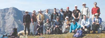
Structure Group Field Trip to Highwood Pass,September 6,2003 - Despite the steep walk up the ridge, everyone made it to the top for an overview of the transverse faults in the hangwall of the Lewis and Rundle thrust sheets.The hot and dry weather was a bonus and we spent over an hour picking out the large number of faults visible in the carbonates of the Livingstone and Mt.Head formations.Unfortunately we did not have time to cross the valley and view the faults up close.We'll do that next year! Deborah Sanderson,field trip leader.
Back row L to R: Thomas Kubli,Bob Gunn,Walter Andreeff,Greg Dyble,Patrick Stinson,Larry Barkley,Tim Hartel,Tom Sneddon,Glen Stockmal,George Thomson.
Front Row L to R: Kevin Brown,Deborah Sanderson,Jean Chatellier,George Ardies,Phil Simony,Geof Say,Kevin Root,Tom Nguyen (not in picture)
From Forelands to Core Zones: Deformation and Tectonic Evolution of Orogenic Belts
A conference and field trip in honour of Dr.Philip Simony
CONFERENCE in Calgary,Alberta June 17-20,2004
FIELD TRIP from Calgary,Alberta to Castlegar,British Columbia (Valhalla Complex) June 20-23,2004
Dr.Philip Simony recently retired from a long and illustrious career in the Department of Geology and Geophysics at the University of Calgary.His 30 years of field research in structural geology and tectonics in the Canadian Cordillera has resulted in an enduring scientific legacy based on meticulous field observations,rigorous analyses,and insightful interpretations.Dr. Simony has also worked collaboratively with the Calgary petroleum industry by leading industry field trips in the Canadian Cordillera and conducting field-based research in the Foreland Fold and Thrust Belt.The aim of the conference is to allow his many students, colleagues,and geological admirers to show their appreciation for Phil’s scientific and
personal contributions to their careers and lives as well as the discipline.Topics that will be highlighted include:
• structural processes and evolution of orogenic belts
• structural traps associated with oil and gas
• relationship between metamorphism and deformation
• plutonism and orogenesis
• structural and tectonic links between forelands and core zones of orogenic belts
WHERE: University of Calgary, Calgary,Alberta,Canada
WHEN: June 17-20,2004
(talks and poster presentations)
June 20-23
(field trip from Calgary,Alberta to Castlegar,British Columbia) led by P.S.Simony and S.D.Carr
Official registration for the conference and abstract submission will begin in October 2003.For more information email or contact Dr.Leslie Reid at the Department of Geology and Geophysics,University of Calgary through:
Email: lfreid@ucalgary.ca
Phone: 403-220-7405
Fax: 403-284-0074
2003/2004 CALENDAR OF EVENTS
DATE: November 2-4,2003
EVENT: Canadian Aboriginal Minerals Association,"Joint Ventures,Joint Rewards:The Resource Industry and Aboriginal Economic Development",11th Annual Conference
LOCATION: Halifax,Nova Scotia
INFORMATION: For more information contact:Ann Osler
The Forum Group for the Canadian Aboriginal Minerals Association,55 St.Clair Avenue West,Suite 125A, Toronto,ON M4V 2Y7,Tel:416-925-0866 / 1-800-4436452,Fax:416-925-1709,Email:cforum@on.aibn.com or visit www.canadaforum.com
DATE: November 26-27,2003
EVENT: Conference Board of Canada,The Exploration Management Forum
LOCATION: The Westin Hotel,Calgary,Alberta
INFORMATION: This event will look at the challenges of generating innovative and successful exploration prospects in a maturing Western Canada Sedimentary Basin with a demographically aging geoscience workforce.It is an opportunity to exchange new ideas with industry peers on how to develop best practices for managing the exploration process.For more information visit http://www.conferenceboard.ca/conf/nov03/exploration /overview.htm
DATE: January 13-15,2004
EVENT: Dolomites:The Spectrum - Mechanisms,Models, Reservoir Development - 3-Day Seminar and Core Conference (A CSPG Seminar)
LOCATION: Calgary,Alberta
INFORMATION: ONE-DAY SEMINAR
Invited speakers for the seminar are:Lawrence Hardie,The Johns Hopkins University (keynote*); Dave Morrow,Geological Survey of Canada;Taury Smith,New York State Reservoir Group;Fiona Whittaker,University of Bristol;Noel James and Kurtis Keyser,Queen's University;Jack Wendte, Geological Survey of Canada
*2002/3 Pettijohn Medallist
CORE CONFERENCE
It is anticipated that there will be 25 core/sample/poster presentations of dolomite case histories,ranging from the Cambrian Cathedral Fm.to the Triassic Baldonnel Fm.The Ordovician (Red River) and Silurian (Interlake) will be on display and the Devonian and Mississippian will be thoroughly represented.The organizers have attempted to solicit examples that encompass the spectrum of dolomitization models.All presentations will remain available for viewing for the two days of the conference.
REGISTRATION: Online only,available December 1st,2003,for both Seminar and Core Conference,or either event:Cap 250 registrants.Fees:TBA.Watch the Reservoir and website for more details.
DATE: March 19-20,2004
EVENT: Water Resources & Energy Development - William C. Gussow Geoscience Conference (A CSPG Seminar)
LOCATION: Raddison Hotel,Canmore,Alberta
INFORMATION: SESSIONS:
Water resources for petroleum exploration and production (Dr.Kevin Parks,Alberta Geological Survey - Chair);Resources for waterfloods,steam generation,etc.
Resource Conflict (Dave McGee,Alberta Environment - Chair):Industrial impacts on surface and shallow groundwater resources.
Handling and disposal of produced water (Dr. Ian Hutcheon,University of Calgary - Chair);Coalbed Methane waters,co-produced freshwaters from shallow gas,SAGD produced water,treatment and compatibility,disposal of acid gases into aquifers,etc.
KEYNOTE SPEAKERS:
Dr.Marios Sophocleous,Kansas Geological Survey
Dr.Bill Gunter,Alberta Research Council
Dr.David Percy,Dean of Law,University of Alberta
CALL FOR POSTERS:
Oral talks will be by invitation only.However delegates are welcome to submit abstracts for poster presentations pertaining to the subject of the three main themes of the conference.Deadline for abstract submission is December 10,2003.For more information,registration,and electronic submission of abstracts contact Lori Humphrey-Clements at (403) 264-5610,Ext.202 or email to lori@cspg.org.
DATE: April 18-21,2004
EVENT: AAPG Annual Convention
LOCATION: Dallas,Texas
INFORMATION: For more information visit www.aapg.org
DATE: May 10-13,2004
EVENT: 2004 CSEG National Convention Theme:Great Explorations – Canada and Beyond LOCATION: Calgary,Alberta INFORMATION: For more information visit www.csegconvention.org
INFORMATION: For more information watch the Reservoir and CSPG website.
PETROLEUM INDUSTRY COURSES
GEOLOGY OF THE WESTERN CANADIAN SEDIMENTARY BASIN
Date: November 18, 19, & 20, 2003
Cost: $1284 incl. GST Instructor: Bill Ayrton
Ideal for those who wish to improve their geological understanding of where and how we look for oil and gas fields in Western Canada.
• To visualize what Western Canada looked like throughout the stages of history, for example, the position of the sea versus land, what sediments were deposited, and what type of life that existed and evolved.
New Course
• To review the importance of each major stratigraphic unit, i.e. Devonian, Mississippian, Cretaceous, etc.
• Discuss the geological and seismic expression of typical oil and gas fields in each unit.
UNDERSTANDING OIL & GAS MAPS, CROSS-SECTIONS & ILLUSTRATIONS
Date: December 2 & 3, 2003
Cost: $856 incl. GST Instructor: Bill Ayrton
Since we show our ideas, our prospects, our oil and gas fields, etc., primarily on maps and cross-sections, this course is important to those working in the oil and gas industry who prepare, use or review this information. Exploration technicians, technical staff new to the oil patch, the management and financial personnel who evaluate our "show and tells" and
recommendations will find this useful. We will:
• Review concepts incorporated into maps and cross-sections.
• Examine different types of maps and cross-sections used to identify oil and gas traps and the significance of each.
• Complete hands-on mapping exercises.
WHO SHOULD ATTEND
New geologists, engineers, geophysicists and landmen, as well as students entering the industry for the first time, will find the courses a very beneficial introduction to the petroleum industry. These courses will be extremely useful to nonprofessional and support staff in the oil and gas industry, as well as accountants, lawyers, brokerage and financial personnel working primarily alongside the oil and gas industry.
TO REGISTER
To request a brochure, to register, or to obtain additional information regarding in-house and upcoming courses contact: Ayrton Exploration Consulting Ltd.
Tel: (403) 262-5440
Email: ayrtonex@telusplanet.net
Or visit our website: www.ayrtonexploration.com
TRENDS IN THE CANADIAN OIL PATCH
The National Energy Board (NEB) recently published a new forecast of Canada’s Energy Future (July 2003).The report covers all sources of energy and uses a ‘scenario’ approach to suggest possible future trends.The two scenarios addressed are:Techno-Vert (TV) – emphasizing rapid technological development and environmental action,and Supply Push (SP) – emphasizing the push to develop known conventional resources.Their data for natural gas from the WCSB has been extracted from the report to create Figure 1 (brown lines).The NEB admits that these scenarios are not predictions but are “intended to challenge and broaden our thinking about the range of possible outcomes in an uncertain world”.
I believe the ‘scenarios’ are closer to reality than the previous forecasts.However,it is disconcerting to see how radically they differ from the NEB’s 1999 forecast of production over the same time period (Figure 1 - red lines,from:Canadian Energy Supply and demand to 2025).Note that the new report supports the conclusion that gas production in the WCSB has peaked and will start to show significant decline by the end of the decade.This compares with the 1999 report
that showed production peaking at 22 bcf/d in 2013 (Case 1).The difference between the various projections is nearly half the supply when we look 12 years into the future!
The Canadian Energy Research Institute has recently published a new report (Potential Supply and Costs of Natural Gas in Canada, June 2003).Their predictions are very bullish (similar to the NEB 1999 study).Clearly, recent results make their forecast suspect.
An unknown author commented “Predictions are fraught with danger especially when they pertain to the future".However,politicians, planners,this industry,and the general population rely on the various agencies to provide reasonably accurate forecasts to determine Canada’s future supply,internal needs,and exports.Unrealistic forecasts are a disservice to Canadians that could potentially jeopardize our economic future.
For the record,I include on the graph (blue lines) my ‘realistic’ case from “Running out of Gas – the need for more and better exploration”,Dave Russum,February 2003 (www.cspg.ca/recorder) and an ‘optimistic’
BY DAVE RUSSUM
case from “The Cow and the Ostrich”,Dave Russum,June 2003 (www.geohelp.ab.ca). These assessments do not include the loss of up to 250 mmcf/d from the potential shut-in of gas overlying the Athabasca tarsands.I believe even the realistic case will require an extraordinary effort by the geoscience community – this is our challenge.
To be continued ...
BIOGRAPHY
Dave Russum has spent more than 25 years exploring for hydrocarbons.He recently completed an exhaustive study of Canada’s future gas supply and demand.He has developed some unique approaches to both shorten the timeframe and improve the results of exploration activities.More information can be found at www.geohelp.ab.ca.
INFORMATION
This is part of a series of snapshots of the Canadian industry designed to provide up-to-date information and give possible insights into the future of oil and gas exploration.Comments are strictly the views of the author;however,your feedback is encouraged (dave@geohelp.ab.ca).
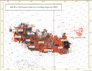
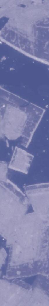
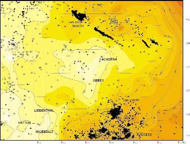
MILK RIVER GAS AT ABBEY, SASKATCHEWAN
The discovery of a large,shallow, unconventional gas reservoir in southwestern Saskatchewan resulted in a notable boost in that province’s activity in 2002.The Abbey area (Figure 1) is expected to produce 0.5 tcf of gas from the Alderson Member of the Cretaceous Milk River Formation.
Renaissance Energy made the initial discovery in November 1999 with a well at Abbey 1-19-21-19W3.That well was perforated in the Milk River and listed as a potential gas well.Within the next few months,a new start-up company,Profico Energy Management,began its own exploration project to the north of Abbey at Lacadena.The first Profico well, a NFW at 7-14-23-18W3,was completed as a potential dual-zone Second White Specks and Milk River gas well.The Lacadena area has since proven to be a core area for Profico. Renaissance followed Profico to the north in April 2000 when it purchased 74.5 sections in T22-23,R16-17W3 for a total bonus of $1,511,807.Land activity in the Abbey / Lacadena area began to heat up with the February 5,2002 provincial land sale when $4.6 million was paid for 22,700 hectares at an average price of $202/ha.That sale was also the point at which Cavell Energy came onto the scene.Cavell purchased over 12,000 hectares of land in the Cabri area,south of Husky Energy (which had by this time taken over Renaissance) and Profico’s activity at Abbey / Lacadena. Sales in the area remained strong through 2002,with the biggest sale for that year occurring on August 13th when operators and agents paid a total of $18.5 million for 38,675 hectares in 60 parcels at an average price of $480/ha.In 2003,the area continues to attract land sale attention in what appears to be a regional extension of the play along trend (Figure 2).
To date,the Milk River has produced over eight tcf of gas from 40,000
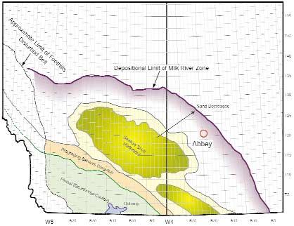
Figure 2. Paleogeography of the Milk River Formation (Modified After:Natural Gas Potential Report in Canada 1997 and the Geological Atlas of Western Canada).
Figure 1. Milk River Completions in Alberta and Saskatchewan (Wells licensed since January 2000 in red).
completions in Western Canada.This total is somewhat skewed as the Milk River is often completed with other zones of the Colorado Group.The Medicine Hat,First White Specks,and Second White Specks zones are typically completed along with the Milk River.This makes a true statistical analysis of any specific zone rather difficult.Average initial gas production (as calculated from a population of 2,755 single and multizone wells that were drilled between 1995 and 2000) from the Milk River is approximately 110 mcf/d.
Recent production data (May 2003) support the economic viability of the
Abbey / Lacadena shallow gas play.At Abbey,183 wells operated by Husky, Profico,and Cavell have flowed 10.2 bcf of Milk River gas since the first well was placed on production in June 2002.At last report,total daily gas production at Abbey was up to 59 mmcf/d or 322 mcf/d per well.The Lacadena results, while not as impressive,are still promising.Eighty-seven wells in the Lacadena and Lacadena South Milk River gas pools have produced a total of 2.8 bcf of gas since the first 24 wells came on stream in September 2002.The combined rate for those wells (operated by Husky and Profico) in May 2003 was 18 mmcf/d or 211 mcf/d per well.
In a recent shareholder report,Husky indicated that,as of June 2003,the company had 140 wells on stream and 50 wells in the process of being tied-in. Second quarter 2003 sales volume averaged 40 mmcf/d,and 40 more wells were to be drilled in the third quarter. Husky predicts reserves of 250 bcf of gas for its 250,000 acres (0.6 bcf/section) following successful area development.
The Milk River Formation forms a northeasterly tapering clastic wedge that extends across southern Alberta and southwestern Saskatchewan (Figure 2).
Continued on Page 36 ...
If you need an accurate database for your evaluation of the Mackenzie Delta then the AOA QuickStudy™ will get you off to a great start.
This study, consisting of high quality data, comprises 12 regional maps covering the entire delta as listed below. The deliverables include paper maps, digital GIS files to suit your format, and a PowerPoint Presentation for just US $7,500.
AOA Mackenzie Delta QuickStudy™
* Terrain
* Gravity Station Location
* Bouguer Gravity
* 1st Vertical Derivative of Bouguer Gravity
* 75 km High Passed Bouguer Gravity
* 200 km High Passed Bouguer Gravity
* Total Field Magnetic Intensity
* 1st Vertical Deriv. of Total Field Magentic Intensity
* 1st Residual of Total Field Magnetic Intensity
* 2nd Residual of Total Field Magnetic Intensity
* Reduced to the Pole Magnetics
* Sediment Thickness
The study is complete and ready for purchase. For more details or to order this product contact: David_Peace@AOAGeophysics.com
JACK PORTERVIGNETTES OF CANADIAN PETROLEUM GEOLOGY
from the October Reservoir
The Extraordinary Odyssey of R.
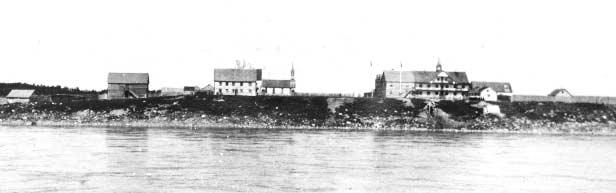
G. McConnell
In a letter to George Dawson dated August 23,1887 from Fort Smith,Richard McConnell states: “I am making arrangements to stay at Fort Providence,as it is a good locality for fish,and one will always have something to fall back upon.It is,besides,below Slave Lake,the ice on which is the great impediment to getting down the Mackenzie early.I am going down Slave River in a canoe,and on the way I will go up Salt River to the ridge in which it heads.From the mouth of the Slave River I purpose going up Buffalo River if I have time. During the winter I will try to visit Horn Hills, and see the country about Fort Rae.” (Summary Report of the Operations of the Geological Society for the years 1887 and 1888,Alfred R.C.Selwyn,Director,p.13A). Accordingly,he obtained a canoe and the services of two natives at Fort Smith to accompany him in his geological investigations for the remainder of the field season.
Geologically,the trip down the Slave River below the 16-mile stretch of rapids was somewhat tedious owing to the continuous blanket of recent alluvium deposits flanking either side of the river to its discharge into Great Slave Lake.However,McConnell did describe an exposure of brecciated limestone (Chinchaga Formation) which forms a prominent cliff seven miles below Fort Smith and which is known as Bell’s Rock.
A side trip was conducted on the 26th of August by ascending Salt River,a small tributary,located on the left bank of the Slave,some eight miles below Bell’s Rock. After a twenty-mile ascent of Salt River, McConnell and his two assistants arrived at the salt springs.In describing their environs, he notes that: “They are situated near the base of the ridge mentioned above,are three or four in number,and are surrounded for some hundreds of yards by a salt-sprinkled and desolate-looking clay flat,through which numerous briny streamlets make their way to the river.” In respect to the springs’ deposits, McConnell further states: “The springs are enclosed by small evaporating basins,the largest of which is about fifteen feet in diameter,and is crusted with a remarkably pure deposit of sodic chloride.The salt obtained here is of excellent quality,and has been used in the Mackenzie River district for many years. ” (McConnell,Part D,Annual Report,1888-89;Report on an exploration in the Yukon and Mackenzie basins,N.W.T.,p. 63D).The source of the brine produced by the springs appears to be the result of the dissolution of sodium chloride associated with the gypsum-bearing limestone ridge (Chinchaga Formation) behind the springs.
The following day McConnell and his party descended Salt River and returned to the Slave arriving,after an uneventful passage,to Fort Resolution on the 1st of September. This fort,located approximately five miles
south of the discharge of Slave River into Great Slave Lake,was established by the Hudson’s Bay Company in 1815.It was,prior to its union with the North West Company in 1821,at the vanguard of the Bay’s activities in the northwest where the North West Company had enjoyed a trading monopoly in the Mackenzie River district for the previous 29 years.
Richard McConnell spent a day at Fort Resolution reconnoitering the northeast side of Resolution Bay in the vicinity of the Fort in hopes of locating in situ strata.Instead,he observed that shoreline was strewn with angular blocks of light-colored limestone, which he deduced had not travelled far.He also remarked of the presence of darkcolored,bituminous limestone erratics.
The next day he and his two native assistants ascended the Little Buffalo River for a distance of 40 miles where he examined outcrops of brecciated,unfossiliferous limestone (Chinchaga Formation) similar to the strata exposed at Bell’s Rock.This river flows into Resolution Bay some 12 miles south of the fort.Its configuration generally conforms to that of the Slave River.Canoe crews,by ascending the Little Buffalo River from Fort Resolution are able to make the “Grand Detour” by traversing a six-mile portage to the Slave River at a point approximately 70 miles from its mouth.As a consequence,the travellers avoid a longer
Mackenzie River in
Hudson’s Bay post.The
to
Mackenzie
route through the braided channels of the Slave’s delta.
Leaving Little Buffalo River on the 4th of September,McConnell and his party skirted the coast of Great Slave Lake for 38 miles to arrive at Sulphur Point.He reports: “Sulphur Point derives its name from the presence there of several springs which emit a strong odour of sulphuretted hydrogen.The flow from these is small,and the effluent water must carry up large quantities of soluble material,as heavy deposits of calcareous tufa occur all around.The water is clear and almost tasteless,and has a temperature of 57 degrees F.” (Ibid.,pp.68D,69D).
After being delayed for three days at Sulphur Point owing to inclement weather,McConnell and his party finally were able to proceed to Hay River,arriving there on the 8th of September.At the entrance to the river he discerned the ruins of the short-lived Hudson’s Bay post,which was established in 1875.McConnell was anxious to ascend the Hay River to the site of Alexandra Falls,a distance of some 34 miles upstream.The presence of an incised river valley bordered by continuous banks of bluish-green shale and associated beds of limestone (Upper Devonian,Hay River Formation) were encountered 10 miles from the falls.It was near here that Richard McConnell discovered, near the base of the cliffs,a prolific occurrence of fossils preserved in beds of friable shale.He collected an assemblage of 40 species of Upper Devonian fauna from these exposures.
After encountering a series of rapids,they abandoned their canoe and pursued the difficult portage route up scree-covered slopes to the base of the falls.McConnell, after viewing the falls and deducing their origin,made an analogy with the formation of Niagra Falls,noting that both are associated with regional limestone escarpments. Further,he inferred that the superjacent resistant limestone capping their surfaces have been progressively breached by water erosion,accompanied by an undercutting of the less resistant supporting shale and carbonate,resulting in a retreat of their scarp fronts.Above the Alexandra Falls,the banks of the Hay River are of very low relief, whereas,McConnell notes that the gorge formed by the river below the falls exposes massive-bedded limestone in excess of 200 feet in thickness.He measured the differential descent of the Hay River at the face of Alexandra Falls utilizing his pocket
aneroid barometer and determined a displacement of 85 feet.
The Alexandra Falls were encountered by William Carpenter Bompas during his decent of the Hay River in 1872.(1994,Hodgin and Hoyle,Canoeing into the Unknown - A Record of River Travel:1874 to 1974;pub. Natural Heritage/Natural History Inc., Toronto,p.164).He selected the name in honour of Alexandra,the wife of Edward, Prince of Wales during Queen Victoria’s reign.
William Bompas had been ordained an Anglican priest in England in 1865 and was
delegated,the same year,to serve as a missionary in the Mackenzie River district. For the succeeding 41 years he resided in the far northwest,being appointed bishop of the Athabasca district in 1874 and later,in 1884 assigned as bishop to the Mackenzie River district.Throughout his lengthy tenure he travelled thousands of miles by canoe on the Mackenzie River and its tributaries as well as those of the Yukon River in reaching the natives,metis,and white people in their isolated and remote communities contained in his dioceses.
Continued on Page 26 ...
McConnell and his two assistants did not continue their ascent of the Hay River beyond the Alexandra Falls.After having spent a week on the river,they retrieved their canoe and arrived back at Great Slave Lake on the 14th of September.After proceeding along the southwest shore of the lake,by way of Pte de Roche and Desmarias Island,they crossed to the eastern tip of Big Island where the fishery depot was located. McConnell estimated the yield of netted fish from the lake that same year would reach half a million pounds.The commonest and most desirable species being the white fish which, according to McConnell,provides a sustainable and agreeable diet of the people inhabiting the region of the Mackenzie River,
especially during the long winter months during periods of game scarcity.
On the 19th of September,McConnell’s party left Big Island by canoe to investigate the “tar springs” located on the north shore of Great Slave Lake,a distance of 20 miles.By following the shore to Pointe aux Esclaves (Slave Point) they continued to Point Brule (Burnt Point) and entered a deep bay (Windy Bay).It was here that one of the native guides brought to McConnell’s attention a conspicuous lobstick,near the bay’s south shore,which indicated the position of the “tar springs”.The lobstick,a native innovation and adopted by the voyageurs, served as a living marker.It consisted of a
VOLUNTEER SOURCE
solitary spruce tree pruned of its branches with the exception of an eye-catching remnant of its uppermost branches,which also served to keep the lobstick alive.
During Richard McConnell’s investigation of the “tar springs”,he observed that: “The springs are situated a couple of hundred yards from the shore,at the base of a low limestone cliff,which runs inland from the lake,and are three in number,each of them being surrounded with a small basin,three to four feet in diameter,filled with inspissated bitumen,while the soil and moss for some distance away is impregnated with the same
Continued on Page 38 ...
Have you been thinking about getting involved as a volunteer with the CSPG or switching roles,or a current Committee position? Does your Committee or individual effort require more volunteers?
The Volunteer Management Committee has implemented a NEW way to help.On the CSPG website (www.cspg.org),you can now access the Volunteer Source.If you are looking to volunteer,this feature will allow you to check for volunteer positions available and submit your name as a possible recruit.Or,if you are already involved as a Society volunteer and need back-up in your pursuits, this is the place to submit your needs so we can help you fill them.Additionally,Volunteer Source has background information on all CSPG Committees,Volunteer Awards and recent recipients,volunteer profiles / testaments,and other helpful Society links.
Our Committee mandate is to provide members with meaningful volunteer opportunities within the Society.We wish to generate a steady supply of volunteers and volunteer opportunities that will create energy and / or rejuvenate present CSPG Committees. Check out VOLUNTEER SOURCE and get involved today! www.cspg.org
Art Silver B.Sc. art.silver@lidarservices.ca (403) 517-3132 “Using laser technology for 3-D earth surface mapping” www.lidarservices.ca
Tony Tubman P.Eng. tony.tubman@lidarservices.ca (403) 517-3131
CSPG VOLUNTEER COORDINATOR
If you are looking for a volunteer opportunity within the CSPG,Blythe will be happy to help you find your volunteer niche.
She can also provide information about any of the Society’s numerous committees if you require it.
Blythe will also assist with finding replacements for current committee volunteers who need a change and help them to find different volunteer opportunities in the Society,if desired.
Blythe Lowe can be reached in Calgary at 403-290-3516. Give her a call!
As in years past,our annual CSPG 10Km race was a terrific time for more than 130 participants.This amazing race attracts a loyal following of endorphin-craving runners and the odd ‘athlete’ who likes to celebrate a little exercise with some pizza and beer.Race day was just about perfect with temperatures of near 18° and rainy days before and after! The course followed the favored route,going out past Crowchild Trail and back to Eau Claire staying on the south side of the beautiful, babbling Bow River.The runners enjoyed a tail wind for the last half of the course to help improve their running times.
Tim DeFreitas and Ashley de Jonge were the fastest male and female geologists and Kees Sinke and Lorna Hawley defended their titles of fastest male and female geophysicists. James Grant was the fastest male overall and
Syl Corbett the fastest female.These welltrained athletes are people to whom we can all aspire.
Our sponsors deserve a great deal of recognition for the success of this well loved CSPG social event.Their generous funding did more than make our event possible,they made it fantastic.A mammoth thanks to all our Sponsors.
Most important,the heart and soul of our race depends upon the participation of many dedicated volunteers and committee members.We wish to extend a huge thankyou to the following volunteers for helping make this race fun and popular.
Committee Members: Boe Baskerville, Dorothy Chen,Fiona Katay,Cindy Koo,Cliff Portier,Mark Shaw,Kees Sinke,Kathy Taerum, Rob Taerum,Vic Urban,Tom Wilson
Please see www.cspg.org for full race results. Please also help me welcome our new race director,Greg Hayden of ChevronTexaco and be sure to mark your calendar now,next year’s race is scheduled for Wednesday,September 15th,2004.
Stuart Mitchell,Race Director 2003.
Thanks to our MAJOR SponsorsThanks to our EVENTSponsors
Accepting abstracts online at http://www.cspgconvention.org/program.htm starting November 1, 2003.
Abstract deadline January 30, 2004
This year’s technical program reflects the importance of integration and collaboration between diverse disciplines, with significant effort and emphasis placed on sessions that capture and promote the common ground between the societies.
We are now soliciting abstracts for oral and posters presentation for technical sessions, including the following themes:
Heavy Oil - from grass roots exploration to final production (project overview, geology and geophysics, drilling and completions, reservoir and production, and facilities)
The multidisciplinary role of petrophysics – interpretation, integration, and case studies. Innovations in the acquisition and application of LWD, and wireline data.
Structural controls on stratigraphy and reservoir distribution
Exploration and development in foreign and frontier regions.
Unconventional gas resources.
Pool studies: clastic and carbonate.
Petrographic characteristics and mineralogic sensitivity of reservoirs in the WCSB.
Recent advances in facies models.
Advances in technique and application of core and cutting analysis.
Individuals are also encouraged to submit abstracts for presentation or posters that are beyond the themes listed, as the scope of individual sessions will be broadened or modified to accommodate relevant material. Papers and posters will be grouped where appropriate to provide multidisciplinary content.
The final two days of the convention will once again feature a number of core presentations at the Alberta Energy and Utilities Board’s Core Research Center, including a subsession, which will focus on a number of significant oil sands projects. Submission procedures and deadlines are the same as those of the technical program.
Individuals interested in leading a field trip or preparing a short course are encouraged to contact the appropriate Committee members or any of the technical program chairs.
For more information please visit www.cspg.org, www.cwls.org, www.choa.ab.ca
CONOCOPHILLIPS GLEN RUBY MEMORIAL SCHOLARSHIPS IN GEOSCIENCES
ConocoPhillips Canada is proud to announce the creation of the ConocoPhillips Glen Ruby Memorial Scholarships in Geosciences.These Scholarships will be awarded to undergraduates in order to promote excellence in petroleum geology and geophysics.The scholarships will be presented each year to second,third,and fourth years students.
$2,000 – 2nd year geoscience student
$3,000 – 3rd year geoscience student
$5,000 – 4th year geoscience student
Selection will be based on academic record and potential.
ConocoPhillips Canada is pleased to recognize and honour a pioneer who has had a lasting influence on the Canadian Oil and Gas industry.Glen Ruby was VP and General Manager of Marland Oil’s Canadian partnership,known as Hudson’s Bay Oil and Gas from 1926 to 1929. He was a driving force behind the inaugural meeting and founding of the Alberta Society of Petroleum Geologists in 1927.(The ASPG was later renamed to become the Canadian Society of Petroleum Geologists.) Since it began,the Canadian Society of Petroleum Geologists has been a forum for geoscientists to share ideas and knowledge about the Western Canadian Basin and other Canadian oil and gas frontiers.This sharing of knowledge has played a fundamental role in the successful development of the Canadian oil industry.Glen Ruby’s legacy can therefore be seen to this day.
Glen Ruby went on to make oil discoveries in Chile and Alaska and the western US.At one time he was credited with having made the most northerly and southerly oil discoveries in the world.He is acknowledged as one of the great pioneers in the global oil and gas industry.
Through Continental Oil Company,Marland Oil/ Hudson’s Bay Oil and Gas,Conoco Canada Ltd.and Phillips Petroleum,ConocoPhillips has been active in Canada since 1880.Our company is proud to honour an industry pioneer like Glen Ruby and we are pleased that these scholarships will help to develop the geoscientists of the future.
For more information or to apply for a ConocoPhillips Glen Ruby Memorial Scholarship,visit www.cspg.org or www.conocophillips.ca
Application deadline is December 1,2003.
The scholarships will be administered through the Educational Trust Fund (ETF) of the Canadian Society of Petroleum Geologists.The ETF is eager to aid others who wish to make contributions such as scholarships or endowments for the promotion of Geoscience in our schools,our community,and our industry.
Donations of $5000+
Alberta Energy Company Ltd.
Andrew Baillie
William A. Bell
Canadian Natural Resources Limited
ConocoPhillips Canada Ltd.
Donations of $1000+
Apache Canada Ltd.
APEGGA
D.L. Barss
Ted Best
BP Amoco
Charles and Sandra Buckley
Tony Cadrin
C.K. Caldwell
Canadian Occidental Petroleum
Continental Laboratories (1985) Ltd.
Decollement Consulting Ltd.
Robert H. Erickson
Harley N. Hotchkiss
Sproule Associates Ltd.
Darol J. Wigham
Anonymous Donors: 2
John A. Downing
George Grant
Andrew Holder
Husky Oil Operations Ltd.
Ian Hutcheon
Jack Gallagher Fund
Tako Konig
Keith A. Lowell
Mike Ware Memorial Fund
Murphy Oil Company Ltd.
Alice Payne & Allin Follensbee Petro-Canada Oil & Gas
Donations of $500+
John Andriuk
S.A. Antoniuk
Belloy Petroleum Consulting Ltd.
Philip R. Brown
Cabre Exploration Ltd.
Canadian Hunter Exploration Ltd.
M.A. Carrigy
Barney Clare
Roger N. Dueck
Andy Evans
Brian F.G. Fischer
Paul Gagnon
R.P. Glaister
Gerald Henderson
Don Holmes
Dave Hutchinson
Mike Hriskevich
Jenik Consultants Inc.
Alan R. and Faye Keevil
Emmanuel Malterr D. Keith MacDonald e Mancal Energy Inc.
Monica Meding
MJ Systems
François A. Montandon
Arne R. Nielsen
Donations up to $499
C.H. Acheson
Shaun E. Alspach
John Ambler
John Andrichuk
Grey H.M. Austin
Denis F. Bacon
Andr
eas Bayer
Lorraine Beaupre
Tim Bird
Thomas Boleantu
Fred G. Rayer
Kathryn Scales
Des Smith
Charles Stelck
Uldis Upitis
Irmgard Weihmann
Harry Woodward
Anonymous Donors: 6
Brian Norford
Reeves Wir Organ Family eline
Rozsa Petroleum Ltd.
Samson Canada Ltd.
John Wall
Charles Wright
Anonymous Donors: 12
James A. Genereux
R.N. Ginsburg
V. Richard Green
Indraman Halim-Dihardja
Syed M. Hasan
Brad Hayes
Clifford Herman
Denise Hodder
W. Gordon Holland
Ernest C. Horvath
Tim Howard
John M. Br
Simon L. Brame owning
Finley Campbell
James E. Christopher
Barney Clare
Dean Clemenson
Canada Post Corporation
Cor Murrary F.J. Cooper
excana
Steve S. Cosburn
Davis MPE, Inc.
Judy & Jodi Hughes
J. Jansonius
Bertram B. Jarrett
David Johnston
Paul A. Johnston
Donald M. Kent
Aubr
ey Kerr
Jim Kirker
Ian K. Kirkland
Sharna Laven
Donald C. Lawton
William G. Dean
Alice Desr
James E. Day ocher
Rein DeWit
James A. Dolph
Drummond Consulting
John L.J. Duhault
Gr
eg M. Dyble
David Erickson
Arthur Evans
Myron D. Franks
Paul Fuenning
Richard C. Galloway
Garuda Resources
Geo-Help Inc.
Patricia Lee
S. Leggett
C. Derek Lester
Wilfred Loucks
Bruce Lyon
Kim MacLean
Robin Mann
David Q. Martin
Barry Mazurkewich
R.C. McCasland Jr.
Margaret MacIntyre
Keith A. McAdam
G. Rae Mor
Ronald M. Misko gan
Coleman W. Morton . Mountjoy
John G. Stout
Eric W
Daryll Myhr
Charles Newmarch
Northstar Energy
Godfrey Nowlan
Karl Olson
R.G. Oicle
Vic Panei
D.J. Parker
Kevin Parks
June & Merv Pedlow
Steven W. Perry
Mitchell L. Peters
Ken Potma
Ray Price
Mrs. J. Purvis
Mr. & Mrs. H. Purvis
S. Silver Purvis
Peter E. Putnam
Indraneel Raychaudhuri
Cindy Riediger
Frances K. Roessingh
Christopher E. Ruud
Lisa Sack
Katherine Sammons
James Scott
Chris Sigvaldason
Philip S. Simony
Claus Sitzler
Scott R. Smith
Brad Spence
Michael S. Stanton
Chris Steudler
John Stobart
Donald Stott
Roy A. Stuart
Suncor Ener
Gerald W. Sullivan gy Foundation
Neil Theissen
Sato Toshiaki
Jens F
Clinton Tippett . Touborg
John Townley III
John Valent
Christian Viau
R.S. Vogan
T John Wall
ed Watchuk
Craig G. Wiebe
Edwin Williams
Gor Ulrich Wissner don Williams
John S. Wonfor ood
Barry W
Brenda Wright
Dale A. Wright
Colin Y
G.C. Yamada eo
Ray Yole
Philip M. Young
Anonymous Donors: 79
2004 CSPG FALL / WINTER CONFERENCE DOLOMITES: THE SPECTRUM – MECHANISMS, MODELS, RESERVOIR DEVELOPMENT
In mid-January of 2004,the CSPG is launching a new venture,the first of what is hoped will be a series of focused mini-conferences which address specific subjects of critical interest to petroleum geologists.
The inaugural event will be a three-day affair,Jan 13th to 15th,dedicated to the always topical and commonly controversial theme of dolomitization and the varied processes responsible for the creation of dolomite reservoir rock. Dolomites are,of course,global in their occurrence,and few if any thick carbonate successions,have not at least locally been altered to dolomite.That being said,the Western Canada Sedimentary Basin is relatively unique amongst the world’s hydrocarbon provinces in having such a high proportion of carbonate strata,and by extension,dolomite reservoirs.It is estimated that a discovered hydrocarbon resource (recoverable sale equivalent) of 105 Tcfe is hosted in dolomitized strata in B.C.and Alberta alone.New discoveries of dolomite-hosted or dolomite-associated pools continue to be made in our basin,and many of these, even in recent years,are truly significant (e.g.Ladyfern,Saddle Hills).As a result of the economic importance of dolomite in the WCSB,many geoscientists from universities,governments,and industry have been encouraged to take advantage of this great natural laboratory to conduct research on the “dolomite dilemma”.The end result of this has been a very significant contribution,from individual case studies to more expansive syntheses,to the global literature on dolomite.Of these many geoscientists,perhaps none is as inextricably associated with dolomite than Dr.Eric Mountjoy of McGill University.Professor Mountjoy and his students have made an immeasurable contribution to our understanding of dolomites in the WCSB and we are especially pleased that Eric has kindly agreed to be our honorary chairman.
The conference will consist of two components.On Tuesday,we will stage a one-day seminar at the Convention Centre,that will feature a slate of internationally recognized speakers,each an expert in various aspects of the dolomite problem.The classroom setting and limited registration will give the seminar a short course/workshop feel that we hope will be particularly conducive to learning,with ample opportunity for questions and informal dialogue.Lunch will be provided on all three days.The seminar will be followed in the early evening by a “beer and bull” reception that promises to be both lively and informative.
On Wednesday and Thursday,the conference will move to the AEUB Core Research Centre where there will be on display over 20 case studies of dolomite, both domestic and international, reservoir and non-reservoir,subsurface and outcrop.The vast majority will focus on subsurface dolomitization and reservoir creation in the WCSB. Formations represented include Cathedral (Cambrian),Red River, Interlake (Silurian),Keg River,Manetoe, Presquile,Slave Point,Swan Hills,Leduc, Nisku,Grosmont,Wabamun,Banff, Pekisko,Midale,Debolt,and Baldonnel. Field studies from the Canadian Arctic, Cayman Islands,and Australia will also be on display.All presentations will be available for the full two days of the core conference,with the doors opening at 9:00 a.m.Wednesday.
The dolomite problem has confronted earth scientists for a very long time.As Francis Van Tuyl wrote in his classic paper “The Origin of Dolomite” in 1914, “the mode of formation of the rock has remained from the first a disputed question and in spite of the fact that a voluminous literature has grown up on the subject,the last word has not yet been spoken”.Our intent is not to provide the “last” word,but over the
course of the three days,it is to present to the participants,the full spectrum of dolomitization models along with some of the most current hypotheses and ideas regarding this enigmatic geologic process.Participants will receive a CD publication containing thoroughly illustrated extended abstracts of all the talks and core presentations.
We anticipate being over-subscribed and remind the Society members that registration will be capped at 250 participants.Registration will be on-line only and will be available as of November 17th.Spots will then be reserved on a first come,first served basis.For more information please visit www.cspg.org or contact the CSPG office at 264 – 5610.
We hope to see many of you there!
Jeff Packard jeff_Packard@br-inc.ca
403-260-8041
Graham Davies gdgc@telus.net
403-289-9156
Conference Technical Co-chairs
Stated simply,the world’s oceans surface waters are supersaturated with respect to the mineral dolomite,yet calcite and aragonite,not dolomite,are the common carbonate precipitates and skeletal mineralogies.The problem therefore,is why is dolomite relatively uncommon in the earth’s crust,and under what special conditions does it occur? To this may be added,from a petroleum geology perspective,where can we predict the occurrence of dolomite and to what degree does it enhance or degrade reservoir quality?
Honourary Chair: Eric Mountjoy
Technical Chairs: Graham Davies and Jeff Packard
Online Registration Opens Monday, November 17th, 2003
CSPG Members: $375 (plus GST)
Non-Members: $450 (plus GST)
Maximum Registrants 250
Online Registration Only
The character of the formation changes from mostly shallow marine shoreline and coastal deposition in the southwest to deeper marine shelf deposits in the northeast.The shallow marine sediments outcrop along the Milk River Valley in southern Alberta and are comprised of three members:the Telegraph Creek Member (interbedded marine mudstones, siltstones and sandstones),the Virgelle Member (thickly bedded,shorelinerelated sandstones),and the Deadhorse Coulee Member (interbedded fluvial sandstones,mudstones and minor coals). These shallow marine sediments grade into the distal marine sediments of the Alderson Member to the north and east. The Alderson Member,which passes basinwards into the laminated mudstones of the Lea Park Formation in central Alberta and western Saskatchewan,is the most interesting of the four Milk River members,as it is the primary gasproducer in the formation.
Throughout much of the Milk River producing area,the Alderson Member reservoir is comprised of two units.On well logs,the lower unit appears sandier and consists of vaguely coarseningupward successions that are between 4m and 10m thick.The lower unit is generally the thinner of the two and is the first to pinch-out to the south.The upper unit is shalier and its coarsening upward successions are less pronounced.A problem in finding gasproducing zones in this section is that they are typically thinner than what a logging tool can detect.For this reason, operators will perforate large intervals, rather than miss production from multiple <1m-thick zones.
Abbey is separated from the main Milk River producing region at Hatton by a structural low.A drop of almost 50m is recorded between the two fields;an area with only a few potential Milk River gas wells.Figure 3 is a Milk River structural contour map,which illustrates the regional deepening to the east through the Abbey area.Abbey is located on the edge of the Bow Island Arch,a saddle
structure that separates the Western Canada Sedimentary Basin from the Williston Basin.
With similar enthusiasm for their respective developments at Abbey, Husky and Profico are expanding this play.Geological constraints have determined a westerly advance,as the reservoir deepens in other directions and increases in shale content to the north and east.Exploratory drilling will most certainly continue for some time at Abbey and the surrounding Milk River fields.A lack of pipelines and infrastructure was a major factor in this prospect area not being developed at an earlier date,although there are gas transmission lines and processing facilities currently under construction. Drilling and development activity by
Husky,Profico,and Cavell over the coming months will bring answers to many of the questions surrounding this new development.At the top of the list is whether the extended production rates will live up to expectations,and whether similar opportunity does indeed exist further west.For certain, their investment in infrastructure indicates the confidence that the existing players have in their ability to make this newest area of Milk River development succeed economically.
INFORMATION
This article is condensed from a more indepth review by Canadian Discovery Ltd. For the full report or information on related products offered by CDL,please visit www.canadiandiscovery.com or call 269-3644.
Figure 3. Structural Contour Map of the Milk River Formation,Abbey and Surrounding Areas.
Accuracy and Efficiency on Every Well, Every Time
Baker Atlas proudly introduces FOCUS
FOCUS is the latest high-efficiency premium openhole logging system designed for Western Canada. Instruments incorporate improved sensor technology into shorter, lighter toolstrings. The result—data accuracy and precision while logging at speeds up to twice as fast as conventional tools. Faster rig up and rig down reduces time at the wellsite and total cost of operations. FOCUS is customer-friendly—you can access your data with 24-hour viewing whenever and wherever via Baker Atlas' Total RECALLSM leading you to more efficient decisions.
Shorter tools. Faster logging speed. The highest data accuracy and state-of-the-art data delivery. Less time on the well. Faster decisionmaking. Lower total cost of operations.
material.A small quantity of pitch is annually taken from these springs and used for boat building purposes,while a much larger supply could be obtained if needed.” and further,in describing the host reservoir,he discerns that: “The rock through which the petroleum ascends here is a heavily bedded greyish, rather coarsely crystalline cavernous dolomite (Presqu’ile formation),and is entirely unlike the bituminous beds south of the lake and down the Mackenzie,which in most cases consists of calcareous shales.The dolomite is everywhere permeated with bituminous matter,which collects in numerous cavities,and oozing up through cracks,often forms small pools on the surface of the rock.” and in respect to the trapping mechanism,McConnell concludes that: “The presence of bitumen in such abundance here also suggests an anticlinal which would bring up lower beds.” (Ibid.,pp.75D,76D).
McConnell,with his two assistants,left the “tar springs” on the 20th of September and returned to the fishery depot on Big Island on the 22nd,having been delayed by heavy winds and a choppy lake.The following day they left for Fort Providence,where they arrived on the 24th of September.The 50mile canoe trip to Fort Providence was uneventful.After travelling 20 miles,they entered the island free main channel of the Mackenzie and continued for another 30 miles where they arrived at a large island fronting the fort.This island diverts the river into two channels.The north channel is broader and accommodates most of the Mackenzie’s flow.The navigable,but turbulent water,of this channel is referred to as “the rapids” and it is here,on the northeast bank that Fort Providence is located.This was to be the domicile of Richard McConnell for the winter of 1887 - 1888 as a guest of Mr.Reid, the Hudson’s Bay officer in charge and his colleague,Mr.Scott,also of the same company.
Fort Providence was erected by the Hudson’s Bay Company in 1855.An adjoining Roman Catholic mission was also established some time later.Because of the post’s strategic location on the upper reaches of the MacKenzie River,it continues to serve as a distribution portal for supplies to the settlements along the Mackenzie River during the river’s ice-free periods.
The construction of the original Fort Providence was overseen by Peter Pond of
the North West Company in 1786 or 1787. Its location was on the north side of Great Slave Lake where the Yellowknife River discharges into Yellowknife Bay.Whereas the modern Yellowknife city is positioned on the northwest side,old Fort Providence was built some 16 miles across the bay on its southeast side.It was abandoned by Hudson’s Bay company in 1823 following its union with the North West Company two years earlier. Probably one of the highlights in the fort’s history occurred when the clerk, Nor’Wester William Ferdinand Wentzel, received,on July 29,1820,John Franklin and his party.Franklin had been appointed by the British Admiralty in 1819 to conduct an overland expedition by descending the Coppermine River and surveying the Arctic coastline eastward from the river’s mouth in search of the elusive North West Passage. This was the first of the two overland expeditions by Franklin,the third,by sea in 1845,resulted in his tragic death as well as those of his entire crew.
Wentzel had been loaned by the North West Company to assist Franklin on his planned route from Fort Providence to his descent of
the Coppermine River.He had hoped that this could be accomplished by organizing local native hunting parties to assure a supply of food for Franklin and his men and to accommodate the British expedition with voyageurs and guides.As well,Wentzel supervised the construction of Fort Enterprise,located on Winter Lake beyond the upper reaches of the Yellowknife River as a refuge for their anticipated 1820/21 winter stopover.
Franklin’s first overland journey to the Arctic coastline,during the period 1819-1822,was a dichotomous episode.Scientifically,it was a success,although the North West Passage remained elusive.However,it had its human costs.During their return from the Arctic coast,it became an horrific experience of excruciating hardships,starvation, cannibalism,and murder.(To the Arctic by canoe 1819 - 1821,The Journal and Paintings of Robert Hood,Midshipman with Franklin; ed.C.Stuart Houston,The Arctic Institute of North America,pub,1974,McGill - Queen’s University Press,fn.21,pp.131,132).
To be continued ...
Figure 1. Drainage Basins of the Mackenzie and Yukon Rivers.