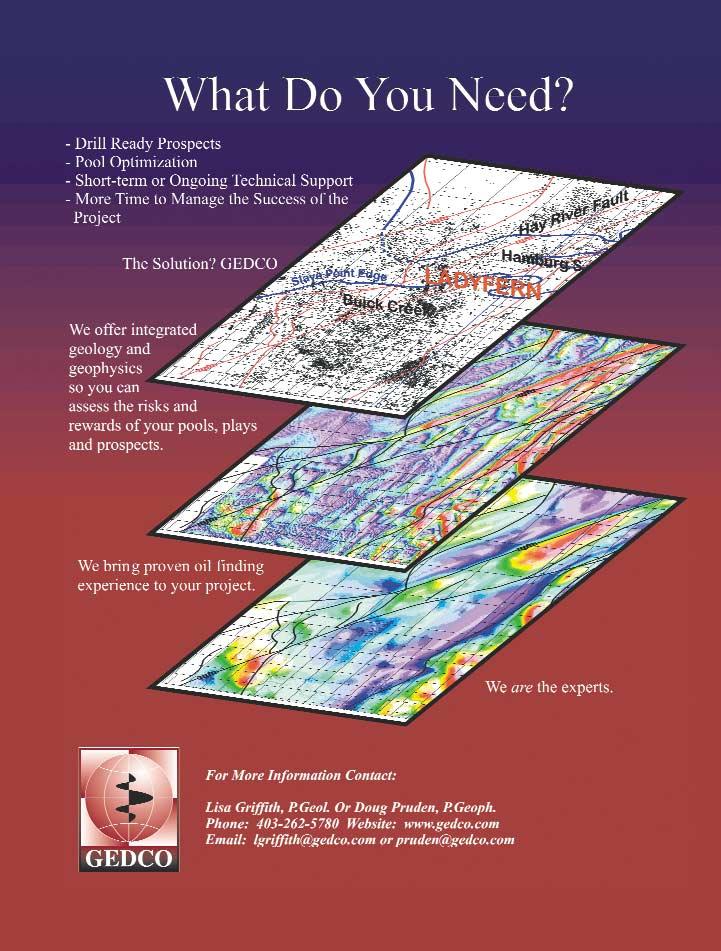
The pursuit of oil & gas can take you to some far off places. Before you make a decision out there, you should know all you can about the geology, history, potential, political climate and cultural traditions.
For more than 10 years, IHS AccuMap has provided the most comprehensive and trusted oil and gas information and software tools for the Western Canadian Sedimentary Basin,Northern Territories, and East Coast. From mineral rights to surface information, E&P data to M&A, we offer an unmatched breadth of data and analysis tools.
From now on, the synergy of tools and expertise which is IHS AccuMap will be known as IHS Energy. No matter where you go in the world, no matter where you are in the process, we can help you see what lies ahead.
CSPG OFFICE
#160,540 - 5th Avenue SW
Calgary,Alberta,Canada T2P 0M2
Tel:403-264-5610 Fax:403-264-5898
Email:cspg@cspg.org Web:www.cspg.org
Office hours:Monday to Friday,8:30am to 4:00pm
Business Manager:Tim Howard
Email:tim.howard@cspg.org
Office Manager:Deanna Watkins
Email:deanna.watkins@cspg.org
Communications Manager:Jaimè Croft
Email:jaime.croft@cspg.org
Conventions Manager:Lori Humphrey-Clements
Email:lori@cspg.org
Corporate Relations Manager:Kim MacLean
Email:kim.maclean@cspg.org
EDITORS
Please submit RESERVOIR articles to the CSPG office.Submission deadline is the 23th day of the month,2 months prior to issue date.(ie:January 23 for the March issue).
To publish an article,the CSPG requires both hard and electronic copies of the document.Text should be in Microsoft Word format and illustrations should be in TIFF format at 300 dpi.For additional information on manuscript preparation,refer to the Guidelines for Authors published in the CSPG Bulletin or contact the editor.
COORDINATING EDITOR & OPERATIONS
Jaimè Croft
CSPG
Tel:403-264-5610 Fax:403-264-5898
Email:jaime.croft@cspg.org
TECHNICAL EDITOR
Ben McKenzie
GEOCAN Energy Inc.
Tel:403-261-3851
Email:bjmck@telusplanet.net
ADVERTISING
All inquiries regarding advertising and technical specifications should be directed to Kim MacLean.The deadline to reserve advertising space is the 23th day of the month,2 months prior to issue date.All advertising artwork should be sent directly to Kim MacLean at the CSPG.
The RESERVOIR is published 11 times per year by the Canadian Society of Petroleum Geologists.This includes a combined issue for the months of July/August.
Advertisements,as well as inserts,mailed with the publication are paid advertisements.No endorsement or sponsorship by the Canadian Society of Petroleum Geologists is implied.
The CSPG Rock Shop is an attractive and affordable way for advertisers to present their services to the CSPG Readership.Spaces are sold at business card sizes (3.5” wide by 2” high) and will eventually fill an entire Rock Shop page. For more information or to book a space please contact Kim MacLean at 403-264-5610,ext.205.
The contents of this publication may not be reproduced either in part or in full without the consent of the publisher.
Design & Layout by McAra Printing
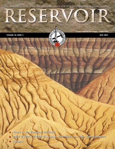
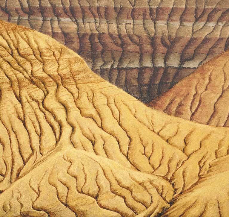
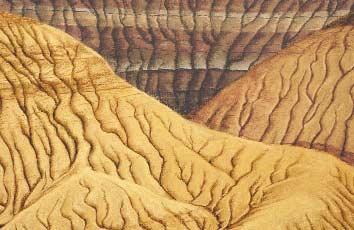
FRONT COVER
Dinosaur Park,Alberta - Wearing down the badlands,erosional features in the Dinosaur Park
pastel by Dave Hills.
THE CSPG GRATEFULLY ACKNOWLEDGES ITS *CORPORATE MEMBERS:
ABU DHABI OIL CO., LTD. (JAPAN)
ARCHEAN ENERGY LTD.
BURLINGTON RESOURCES CANADA ENERGY LTD.
CALPINE CANADA
CANADIAN FOREST OIL LTD.
CONOCOPHILLIPS CANADA RESOURCES LIMITED
DEVON CANADA CORPORATION
DOMINION EXPLORATION CANADA LTD.
ECL CANADA
EL PASO OIL & GAS CANADA, INC.
HUNT OIL COMPANY OF CANADA, INC.
IHS ENERGY
IMPERIAL OIL RESOURCES LIMITED
LARIO OIL & GAS COMPANY
MJ SYSTEMS
MURPHY OIL COMPANY LTD.
NCE RESOURCES GROUP INC.
NEXEN INC.
NORTHROCK RESOURCES LTD.
PENN WEST PETROLEUM LTD.
PETRO-CANADA OIL AND GAS
SAMSON CANADA
SHELL CANADA LIMITED
SPROULE ASSOCIATES LIMITED
SUNCOR ENERGY INC.
TALISMAN ENERGY INC.
TOTALFINAELF E&P CANADA LIMITED
UPTON RESOURCES INC.
*CORPORATE MEMBERS AS OF MARCH 24, 2003
CORRECTION
The following should have run as an addition to the “Net-to-Gross” ratio article from the April Reservoir:
To supplement this article,an example spreadsheet that interactively calculates the various thicknesses and shows schematically the categorization of each depth increment is available at the Core Lab website:go to www.corelab.com/rtd and follow the Publications / Articles link to the Net-to-Gross Ratio article.
This is my first term on the Executive.Although I have been an active volunteer for a number of years,the first few months in the role of Vice President have given me a new perspective on the scope of activities and services that the Society provides for its members.It has also helped to crystallize the realization that as the demographics of our membership change and the industry continues to evolve,the CSPG will play an important role in the professional development of geoscientists.In order to continue to organize events such as the upcoming 2003 CSPG/CSEG Convention,we will require a continued strong volunteer effort.In looking to the future,we have to develop a strategy to attract new young people into the geosciences and,more specifically,into our industry so that the geosciences will remain strong.
The annual convention provides a major opportunity to network and exchange ideas with colleagues and to access training opportunities. This year,the convention is being held jointly with the CSEG and will provide a forum for the crosspollination of geological and geophysical ideas and concepts.The organizing committee has done an excellent job soliciting in excess of 250 technical presentations,15 field trips,and 20 short courses. As well,demand for exhibit space was such that additional space was added so that attendees will be able to obtain information about a greater variety of technologies from a larger number of vendors.If you have not done so,please take the time to review the latest Convention information in this edition of the Reservoir and on the website. I am sure you will enjoy the conference and will appreciate the volunteer efforts of the organizing committee in putting together what promises to be another successful event.
In coming years,joint conventions will be held with other organizations such as the Canadian Well Logging Society and the Canadian Heavy Oil Association in 2004 and with the AAPG in 2005. Plans are also being made to meet again with the CSEG as well as with other geoscience organizations.We anticipate that these joint conventions will provide further impetus for the sharing of ideas between various disciplines and interests.In addition to these major annual conventions,mini-conferences and core conferences dedicated to specialized topics are being planned to give our members additional opportunities to present and exchange ideas with their colleagues.For example,a “Dolomites”
A MESSAGE FROM THE VICE PRESIDENT
Seminar and Core Workshop and a “Groundwater Resources and Energy Development” MiniConference have been scheduled for 2004.Further information regarding these and other technical meetings may be found on the CSPG website.
Conferences,seminars,and the ongoing committee activities cannot continue without the involvement of our volunteers.At a recent strategic planning session of the Executive,it was recognized that volunteering is both a strength and weakness of the Society.In the past,the volunteer support has been the foundation for the success of the Society and has enabled us to provide a wide variety of programs and services.Currently,however,we are experiencing a reduction in the number of available willing volunteers as our members try to balance family and changing work pressures.This situation is not unique to the CSPG;many volunteer-based organizations are going through similar experiences.Therefore,one of our major challenges is finding the volunteers to plan and organize technical meetings as well as to staff the various committees,including the Executive.Our office staff has,by necessity,grown to help run the Society.We do recognize,however that hiring more staff is not the answer to running a successful organization.We must encourage our members to volunteer.As with many organizations,there is a core group of members who volunteer on a regular basis.I appeal to you to help expand that core group by volunteering some of your time to help keep the Society active and strong.The opportunities are many;a call for volunteers for the 2004 Conference has already been made. Contact our Volunteer Coordinator,Blythe Lowe at 403-290-3516 or the CSPG office.
The future of the CSPG and the role of geologists in the petroleum industry are going to be dependent on our ability to attract young graduates.We have all seen the cyclic nature of our industry.Related to that cyclicity has been the increases and decreases in geology enrollment in universities.To encourage young people to enroll in the geosciences we have to convince them that we are not in a sunset industry and that there are significant career opportunities to develop and apply new technologies to help us find and improve recovery of our hydrocarbon resources.We need to get this message out to students in Kindergarten to Grade 12 levels,before they decide on their university programs.Whenever the opportunity arises,I urge you to speak to students about our industry and,in particular, about the challenging and rewarding careers they can have in the geosciences.
In conclusion,I want to urge you to attend the upcoming conference and give serious thought to donating your time and talents to keeping our Society strong.
Craig Lamb Vice President
GEDCO’s Interpretive Services:Integrated Geophysics and Geology Helping You Achieve Success
Doug Pruden, P.Geoph and Lisa A. Griffith, P.Geol.
The Value of Geotechnical Integration
“Oil is found in the minds of men (and women)”, to paraphrase Hubbard.
If the minds of geoscientists hold the key to successful hydrocarbon exploration and exploitation, we need to understand how we can best leverage them. Integration of disciplines is one important way to take advantage of differing perspectives, experiences and training.
It is well understood that a complete earth model cannot be extracted from the limited observations provided by geology or geophysics individually. For over 30 years, the integration of geological and geophysical data into unified interpretations has been the strategic objective of the major oil companies. As a result of their efforts, the integration of geotechnical data has become a desired “best” practice throughout most of the petroleum industry. However, the execution of this objective is inconsistent.
In immature frontier basins and international areas geophysics is king. Geophysical data dominates because it is relatively inexpensive to acquire over extensive geographic areas. Prospects are large, structurally defined targets easily visible on seismic. Well control is limited and a stratigraphic framework is constructed using seismic stratigraphy.
In this high risk environment geologists and geophysicists jointly interpret seismic, well data, and any other available information to create an earth model. The goal is to define and reduce the risks of exploration. Integration of all available data is clearly essential – and well done by most practitioners.
In more mature basins this meeting of the interpretive minds takes a different form. Geophysically, the emphasis shifts from regional seismic to smaller, prospect oriented 2D and 3D seismic surveys. Geologists and engineers use rich well and production data sets to provide a geological framework which more tightly constrains the seismic interpretation. In this way, all available data is analyzed from
differing perspectives and integrated into an earth model which reduces exploration risk.
Ironically, the wealth of data a mature basin provides may not necessarily result in a more well-defined earth model. The intense demands of operating in a mature basin make it difficult for technical staff to make optimal use of the available data. This means that pieces may be missing from the detailed integration required to create a complete model. Lack of time, resources, or simply management priority can have an unfortunate result – higher risk.
At GEDCO, we offer the power of integrated geology and geophysics to help you assess the risks and rewards of your pools, plays and prospects. Our team has expertise in all areas of geophysics and geology. We have actively integrated multiple data sets, produced drill ready prospects and optimized pools for oil and gas companies – both large and small. We have over a century of combined experience in exploration, development/exploitation and reservoir characterization. Our experience across Canada and around the world means that we can produce solid results in a timely, costeffective manner.
We are experts, able to bring proven oil finding experience to your project. We can provide you with individuals or teams for short term or ongoing technical support. We can help you meet your technical objectives and allow you to dedicate more time to managing the success of your project.
GEDCO – Experts with proven oil finding experience
MAY LUNCHEON
Gas Hydrates
in
Canada: Overview of recent research activities by the Geological Survey of Canada and Partners
SPEAKER
Scott R.Dallimore Geological Survey of Canada
AUTHORS
Scott R.Dallimore
Geological Survey of Canada
Kirk Osadetz
Geological Survey of Canada
11:30 am Thursday,May 8,2003
TELUS CONVENTION CENTRE CALGARY, ALBERTA
Please note:
The cut-off date for ticket sales is 1:00 pm,Monday,May 5th.
Ticket price is $25.00 + GST
Gas hydrates are crystalline substances composed of water and natural gas,in which a solid water lattice accommodates gas molecules in a cage-like,clathrate structure.Gas hydrates are widespread in permafrost and marine settings.The basic geologic conditions required for their formation include cold temperatures, intermediate pressures (generally >3 MPa hydrostatic pressure),suitable reservoir conditions (porosity and permeability),and a source of natural gas.The amount of natural gas occurring in the form of gas hydrate is enormous;however,estimates are speculative and range over three orders of magnitude,from about 2,800 to 7,600,000 trillion cubic meters.Research interests in gas hydrates have focussed on three themes:gas hydrates as a future energy source;gas hydrates as a geohazard,both to conventional oil and gas exploration and in relation to marine slope instability;and gas hydrates as a possible natural source of greenhouse gas influencing global climate change.
Over the past decade the Geological Survey of Canada (GSC),working with a variety of partners,has conducted regional studies of gas hydrates in Canada. Concentrated occurrences of gas hydrates have been identified offshore of Vancouver Island and in association with thick permafrost in the Arctic Islands and Mackenzie-Beaufort region.A number of dedicated gas hydrate research wells have
also been completed.Most notably,in 1994,Leg 146 of the Ocean Drilling Program investigated gas hydrates in the Cascadia margin,offshore of Vancouver Island.Research well programs,each with dedicated scientific and engineering objectives,were completed at the Mallik gas hydrate field in the Mackenzie Delta in 1998 and 2002.The most recent program at the Mallik site included the first modern production testing of gas hydrates.
The GSC has recently begun a national gas hydrate research program to advance energy-related gas hydrate research in Canada and to assess environmental/geohazard issues that may be related to possible development.This talk will give a brief overview of gas hydrate science,the distribution of gas hydrates in Canada,and an assessment of key research needs for the future.
BIOGRAPHY
Scott Dallimore has worked as a research scientist at the Geological Survey of Canada since 1984.His background is in geological engineering and geotechnical science,having completed a Bachelors degree at Queens University and a Masters degree at Carleton University.Scott has spent most of his career working in the Mackenzie Delta/Beaufort Sea area on a wide variety of research topics from permafrost to pipeline engineering.His work on gas hydrates began in 1992 when a permafrost research program with the GSC/Shell and Imperial Oil collected the first gas hydrate core samples from a permafrost occurrence.Since that time,he has led two large,research-well programs at the Mallik field in the Mackenzie Delta.
Mr.Osadetz is a graduate of the University of Toronto,Ontario (B.Sc,,1978;M.Sc.1983).He is the Manager of the ESS Gas Hydrates – Fuel of the Future? Program and Head,Energy and Environment Subdivision at the Geological Survey of Canada’s Calgary Office.Energy and Environment Subdivision has national responsibility for organic geochemistry,organic petrography and hydrocarbon and coal resource assessments,and regional responsibility for environmental geoscience,particularly as related to the impact of fossil fuel production and consumption.He leads the national program of hydrocarbon resource evaluation for Canada as well as having research interests related to the characterization of hydrocarbon systems Canadian sedimentary basins, particularly the Williston Basin,Intermontane Basins,and the Foreland of the Western Cordillera.Before joining the Geological Survey he worked in Calgary as a geologist in the exploration departments of Gulf Canada Resources Inc.and PetroCanada Resources Inc.
NEW CSPG MEMBERS
Jillian L.GarnettAssociate
Dave C.JenkinsAssociate
Tracey A.WilliamsAssociate
Kevin A.BloomRegular
Richard W.EvoyRegular
Corina NeaguRegular
Lawrence H.PayneRegular
Michael H.PortigalRegular
Osman Salad HersiRegular
Gareth R.ChalmersStudent
Cindy C.RobinsonStudent
MAY LUNCHEON
Jackpine Creek Magnetic Anomaly:Identification of a Buried Meteorite Impact Structure
SPEAKER
Serguei Goussev
Geophysical Exploration & Development Corporation (GEDCO)
AUTHORS
S.A.Goussev,R.A.Charters, J.W.Peirce,W.E.Glenn
Geophysical Exploration & Development Corporation (GEDCO)
11:30 am Thursday,May 22,2003
TELUS CONVENTION CENTRE CALGARY, ALBERTA
Please note:
The cut-off date for ticket sales is 1:00 pm,Monday,May 19th. Ticket price is $25.00 + GST
Buried meteorite impact structures/craters can be very good petroleum prospects.Steen River in Alberta (~1,000 BOPD,~35 MMCF/d),Viewfield in Saskatchewan (27 MMbbl),Ames Holes in Oklahoma (18 MMbbl,14 BCF),Red Wing Creek in North Dakota (40-70 MMbbl) are examples of oiland-gas fields producing from buried impact craters.The meteorite impact process is quite remarkable as it can create a trapgenerating structure (rim and,frequently,
JUNE
LUNCHEON
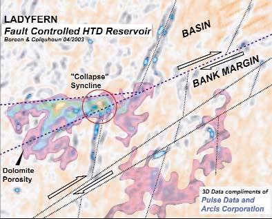
Ladyfern
SPEAKER
Thomas Boreen
Suncor PGS
AUTHORS
Thomas Boreen
Suncor PGS
Kelvin Colquhoun
Apache Canada Ltd.
11:30 am Tuesday,June 12,2003
TELUS CONVENTION CENTRE CALGARY, ALBERTA
central uplift) and reservoir rock (ejecta piles and breccia infill),both at the same time.
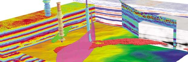
GEDCO’s processing of new high-resolution aeromagnetic (HRAM) data reveals a circular magnetic anomaly at Jackpine Creek,British Columbia.Geological and geophysical evidence – including isopach maps from formation tops in wells,a 2-D seismic line and forward magnetic modeling – is consistent with identification of this anomaly as a magnetic signature of a buried meteorite impact structure.
The Wapiti HRAM survey was flown by Fugro Airborne Surveys with 600 X 1,800 m line spacing at an average height of 200 m above the ground.Standard preprocessing provided the reduced-to-pole Total Magnetic Field grid.This grid was processed with various signal enhancement techniques.The 3-6 km band-pass filter reveals a nearly circular,negative magnetic anomaly.The “shallow” version of the cascaded Goussev filter shows a distinct oval-to-circular positive anomaly.
Since filtered magnetic maps suggest the magnetic sources of the anomaly are located within the upper sedimentary section,several isopach maps were constructed over this interval.The Bluesky-to-Cadomin isopach reveals a circular area defined by a decrease in thickness at center and increase in thickness at periphery.The magnetic anomaly on the cascaded filter map correlates with the isopach thickening.
Please note:
The cut-off date for ticket sales is Wednesday,June 9th. Ticket price is $25.00 + GST
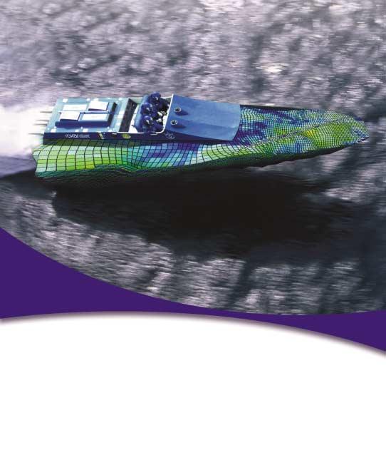
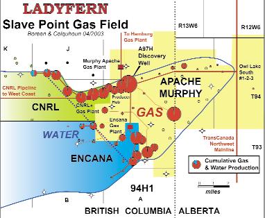
A Slave Point gas field discovery made in winter 2000 at Ladyfern in British Columbia (Block H/94-H-1) is the largest onshore North American gas accumulation found in 15 years.The discovery underlies established pipeline fairways and individual wells are capable of production rates in excess of 100 mmcf/d.By the close of March 2002,40 wells were producing 785 million cubic feet of gas per day,5% of Canada’s natural gas stream.The Ladyfern
A 2-D seismic line over the SW area of the anomaly reveals components of a buried crater in the Bluesky-Cadomin interval.Estimated displacement across rim faults is about 80-100 m.Rim-to-rim diameter of the crater is about 22-24 km, with depth of occurrence at about 2,500 m below the surface.The estimated time of impact is after Cadomin but before Bluesky deposition.
A 2-D magnetic forward model constructed from the seismic interpretation shows a trough of 0.7 nT on a 3-6 km band-pass filter profile and a peak of 0.12 nT/m on the cascaded Goussev filter profile above rim faults.These values correlate quite well with the observed data.
The results of this study show that 1) HRAM survey is a cost-effective way to prospect regionally for buried impact craters and 2) HRAM survey data is sensitive to magnetic anomalies generated by faults where offsetting magnetized formations may have throws as small as 80-100 m at depths to 2,500 m.
BIOGRAPHY
Serguei Goussev graduated from the Moscow State University,Russia.He worked as a geophysicist in the western Pacific region, Arctic Siberia,South Yemen,and Moscow before joining GEDCO in 1996.Since then,he has been working mostly with high-resolution aeromagnetic and airborne gravity data.
Slave Point gas field is areally extensive,up to 100 square kilometres,with a gas column greater than 100 m,and estimated reserves of 500 bcf to 1 trillion cubic feet of gas in place.Discovery of this most recent onshore “elephant” highlights Canada’s tremendous untapped energy potential.
The Upper Devonian Slave Point Formation in north-central Alberta and British Columbia,Canada is an intermediate depth (2,000-3,500 m) bioclastic carbonate.A basement strike-slip structural regime associated with the Hay River Fault Zone has controlled areal distribution patterns of
Continued on Page 14 ...
Continued from Page 12 ...
reservoir facies in the Slave Point Formation and directly influenced internal stratigraphy and cyclicity.At Ladyfern,episodic reactivation of these faults has resulted in extensive fracturing and created conduits for hydrothermal fluids which have variably leached,dolomitized,and cemented the rock.In areas of maximum extension near fault intersections,intense dissolution, brecciation,and hydrothermal dolomitization has resulted in seismically resolvable collapse synclines at the Muskeg and Slave Point levels.The Ladyfern discovery confirms the viability of using wrenchfault-based hydrothermal dolomite exploration models for prospecting in carbonate units worldwide.
JUNE LUNCHEON
Managing Hydrogen Sulfide the Natural Way
SPEAKER
Todd Beasley
New Paradigm Gas Processing Ltd.
11:30 am Thursday,June 24,2003
TELUS CONVENTION CENTRE CALGARY, ALBERTA
Please note:
The cut-off date for ticket sales is Wednesday,June 18th.
Ticket price is $25.00 + GST
North America's insatiable demand for energy is forcing Exploration & Production companies to search in increasingly populated areas.In many of these areas, hydrogen sulfide (H2S) is encountered. Due to the health,safety,and environmental concerns of the surrounding landowners and occupants, many of these projects face strong opposition and,inevitably,costly delays.
Bio-technology,specifically the use of sulfurreducing bacteria,has shown great promise to help with the production of these impurity-laden streams in an economic, intrinsically safe,and emissionless manner with respect to H2S and its combustion byproduct,sulfur dioxide (SO2).
BIOGRAPHIES
Thomas Boreen is a senior exploration geologist at Suncor Prospect Generation Group in Calgary,Alberta.He started his oil and gas career as a battery operator for Husky Oil Operations in 1981.He received a B.Sc. Honors in Geology from University of Saskatchewan in 1987,a M.Sc.in clastic sedimentology from McMaster University in 1989,and a Ph.D.in carbonate sedimentology from Queen’s University in 1993.Since graduating,Dr.Boreen has worked as an exploration geologist and technical advisor for a number of international oil companies including Home Oil Company,Anderson Exploration Ltd.,Shell Canada Ltd.,Apache Canada Ltd.,and Suncor PGS.He has
published numerous technical papers and has received CSPG awards for Outstanding Ph.D. Thesis (1995),Link Award for outstanding technical presentation (1996),and C.S.P.G. Best Core presentation award (2002).
Kelvin Colquhoun is a senior staff geophysicist at Apache Canada Ltd.in Calgary,Alberta.He graduated with a B.Sc.in Physics from Brandon University in 1990 and was trained and employed as a geophysical processor and interpreter by Shell Canada from 1987 to 1999.Since joining Apache Canada Ltd.in 1999 Kelvin has been instrumental in the discovery of numerous high-impact Slave Point oil and gas pools in northeast B.C.and Alberta.
This presentation will include discussions on the pioneering discovery of chemosynthetic bacteria around deep sea hydrothermal vents.These vents eject,into the surrounding ocean,H2S with concentrations in excess of 85% and at temperatures over 800 degrees Fahrenheit. A family of sulfur-reducing microorganisms lives in these vents and feeds on the H2S as it is released.Although first discovered at deep sea vents,sulfur-reducing bacteria are some of the most common life forms on Earth.In fact,some scientists believe Earth's ability to sustain biological life is,in no small part,due to their presence.
New Paradigm Gas Processing Ltd.of Calgary,together with Shell Global Solutions International B.V.and Paques Natural Solutions,both of the Netherlands,have successfully commissioned the "World's First High Pressure Biological Gas Desulfurisation Technology” for Canada's largest exploration and production company,Encana,using naturally occurring, sulfur-reducing Thiobacillus microorganisms.
The project received 100% unanimous support of the surrounding landowners and occupants.As a result,regulatory approval was received in under seven days.
BIOGRAPHY
Todd Beasley is the founder of CCR Technologies Ltd.and is the co-inventor of its gas-treating chemical (GTC) refining technology.
GTCs-ethanolamines and glycols- are in use in over 98% of the world’s natural gas processing and petrochemical refining complexes and over time they accumulate non-regenerable impurities.Performance reduction usually results.CCR's technology is uniquely capable of the simultaneous removal of every major group of impurity,accomplished while the production facility remains in full operation.
For these achievements,Todd was co-awarded nine method and apparatus patents.In 1996, he took CCR public and in 1997,he established New Paradigm Gas Processing Ltd.,a company dedicated to the creation or acquisition of biotechnology to be used in the purification of H2S-laden gas streams.In 1999,New Paradigm joined forces with Shell Global Solutions International B.V.to advance its biotechnology and in early 2002,New Paradigm,Shell,Paques,and EnCana were successful in commissioning the world's first high-pressure natural gas application of the technology near Patricia,Alberta Canada.
Licensed in Canada and in Central and South America by New Paradigm,the technology was developed by Shell Global Solutions and Paques Natural Solutions.It was originally developed for waste-water treating but has now successfully been applied to low- and high-pressure gas streams as well as refinery gas,synthesis gas,and liquid streams.
New Paradigm's website is www.npgas.ca
20TH ANNUAL CSPG SQUASH TOURNAMENT
The 20th Annual CSPG Squash Tournament, held on February 20-22,2003,was a great success.The tournament had 125 participants whacking squash balls,socializing,and talking rocks.Our generous and committed sponsors enabled us to put on a first-rate tournament and provide lots of refreshments and prizes.As organizers,we would like to thank all of our sponsors for their support.
TOURNAMENT SPONSOR:
Tucker Wireline Services.
PREMIERE SPONSOR:
Baker Hughes Canada
PLATINUM SPONSORS:
Northstar Drillstem Testers,Reeves Wireline, Geo-X Systems Ltd.,Pason Energy Systems, Geo-Logic Systems Ltd.,Solid State Geophysical Inc.,Global Link Data Solutions Ltd.,ECL (Decollement),Tokpella Resources Ltd.,Belloy Petroleum Consulting Ltd.,Wellsite Gas Detection Inc.,Pulse Data Inc.,Blue Castle Corp.,United Oil and Gas Consultants
SPECIAL THANKS TO COMMITTEE MEMBERS: Andrea Henry,Colin Thiessen,Alan Rutherford,Randi Christiansen,Andrew Royle, David Caldwell,Chris May,Randy Smith,Jessie Gould,Andrea Bell,Greg Loughlin,Dwayne Sparks,and Brian Fyke
TOURNAMENT CHAMPIONS:
Mens A: Dave Safton
Mens A Runner-up: Kevin Richmond
Mens A Con: Harry Issler
Mens B: John Schnessle
Mens B Runner-up: Ken Chong
Mens B Con: Ed Chow
Mens C: Ryan Barnett
Mens C Runner-up: Patrick Stinson
Mens C Con: Bob Bonner
Mens D: Simon Brame
Mens D Runner-up: Malcolm Albery
Mens D Con: Chris Slind
Mens E: Darryl Lang
Mens E Runner-up: Dion Lobreau
Mens E Con: Garnett Knopp
Womens A: Cindy Riediger
Womens A Runner-up: Karen Blakey
Womens B: Hannah Laplante
Womens B Runner-up: Flo Reynolds
Womens C: Andrea Henry
Womens C:Runner-up: Tina Chow
Womens D: Jessie Gould
Womens D Runner-up: Randi Christiansen
Womens E: Jackie Lobreau
Womens E Runner-up: Stacia Scappak
Womens E Con: Rebecca Dunne
Kent Wilkinson
Chairman 2003 CSPG Squash Tournament
STRUCTURAL DIVISION
Enhanced Fluid Flow in Critically Stressed Fractures, Implications for Reservoir Permeability
SPEAKER
Balz Grollimund
GeoMechanics International Palo Alto,California
12:00 Noon Thursday,May 1,2003
+30 (3rd floor) ConocoPhillips Conference Centre (inside Sunterra Market), Gulf Canada Square, 401 - 9th Avenue SW. Calgary, Alberta
Many aspects of producing hydrocarbons from fractured reservoirs rely on a thorough understanding of fracture permeability.Optimizing drainage of fractured reservoirs requires understanding of the distribution and orientations of permeable fractures.Preexisting fractures in the earth’s crust generally evolve over geologic time as the result of multiple episodes of deformation.Although ”conventional wisdom” says that fractures have a preferred orientation in a given reservoir, they usually are found to be at a wide range of orientations.Furthermore,
according to the results from a case study in the Monterey formation in Central California,the commonly held view that “open” fractures (mode 1) provide pathways for fluid migration does not appear to be applicable.Rather,episodes of shear displacement create increased permeability,which is maintained with continued deformation,thereby sustaining open conduits for fluid migration. Therefore,fractures optimally oriented for shear failure in the present day stress field are more likely to be permeable than fractures that are poorly oriented with respect to the present-day stress field.
Wellbore images provide fundamental data for assessing fracture permeability and reservoir optimization.Fracture orientation and distribution can be directly determined from image logs.In addition,wellbore image logs provide information about drilling induced compressive and/or tensile wellbore failure,from which information on the present-day in situ stress state can be derived.Using the knowledge of the stress field in combination with the determined fracture orientations,the resolved shear and normal stress on each fracture can be determined and evaluated for proximity to slip.A correlation between high fluid flow and critically
stressed fractures has been documented in a variety of reservoirs worldwide. Knowing the orientations of permeable fractures can be used to optimize well trajectories such that a maximum amount of permeable fractures is intersected.
BIOGRAPHY
Balz Grollimund is working as a geomechanical consultant for GeoMechanics International (www.geomi.com),a consulting company headquartered in Palo Alto,CA.He received a diploma (equivalent to M.S.degree) in Structural Geology from ETH in Zurich, Switzerland in 1996 and his M.S.degree and Ph.D.in Geophysics from Stanford University in 1999 and 2000,respectively.During his Ph.D. in the stress and crustal mechanics group of Mark Zoback he was studying the in situ state of stress offshore Norway and its implications for fault seal integrity.
INFORMATION
There is no charge.Non-members of the CSPG are also welcome.Please bring your lunch.Desserts are provided by Norwest Laboratories.Beverages are provided by HEF Petrophysical.For details or to present a talk in the future,please contact Luc Lalonde at 403645-5528,e-mail:Luc.Lalonde@EnCana.com or Eric Hanson at 403-233-3250,e-mail: Eric.S.Hanson@conocophillips.com
EMERGING PETROLEUM RESOURCES DIVISION
Gas Hydrate Distribution and Volume in Canada
SPEAKER
Kirk Osadetz
Geological Survey of Canada
12:00 Noon
Wednesday,May 14,2003
+30 (3rd floor) ConocoPhillips Conference Centre (inside Sunterra Market), Gulf Canada Square, 401 - 9th Avenue SW. Calgary, Alberta
Gas hydrate,a solid form of natural gas and water,is inferred to occur widely in Canadian polar and continental shelf regions and in sediment of outer continental margins.Although direct indications are few and widely separated, conditions potentially favorable for gas hydrate formation and stability cover vast areas and indicate an immense potential for natural hydrocarbon gas in the upper two kilometers of many Canadian sedimentary basins.We have analyzed the potential of gas hydrates for the vast continental shelves and Arctic permafrost regions of Canada (Mackenzie Delta-Beaufort Sea and
Arctic Archipelago in the north;Davis Strait,the Labrador Shelf,Scotian Shelf, and Grand Banks of Newfoundland, along the Canadian Atlantic margin;and the Canadian Pacific margin).Our conservative calculation suggests 10101012 m3 of gas hydrates in these regions with an associated methane gas potential estimated to be in the range of 10121014 m3.Geographically this methane potential is distributed in the following regions:0.24 - 8.7 X 10¹³ m3 in the Mackenzie Delta-Beaufort Sea,0.19 - 6.2 X 10¹⁴ m3 in the Arctic Archipelago,1.9 - 7.8 X 10¹³ m3 on the Atlantic margin, and 0.32 - 2.4 X 10¹³ m3 on the Pacific
margin.The total amount of methane in hydrates in Canada is estimated to be 0.44 - 8.1 X 10¹⁴ m3,as compared to a conventional Canadian hydrocarbon gas potential of approximately 0.27 X 10¹⁴ m3.This comparison implies that gas hydrates represent a possible future source of North American energy,if the gas can be recovered and separated from the hydrate form.
BIOGRAPHY
Kirk.G.Osadetz is a graduate of the University of Toronto,Ontario,Canada,(B.Sc.degree,1978; M.Sc.degree,1983).He is the Acting Director of Natural Resources’Calgary office where is he normally Head of the Energy and Environment Subdivision.He is the manager of Natural Resources’research program into the fuel potential of natural gas hydrates and the leader of a Program of Energy Research and Development project into the development of improved methods of undiscovered petroleum resource assessment.He contributes to National Energy Board studies of Canadian Energy Supply
and The Canadian Gas Potential Committee’s studies of undiscovered natural gas resources.The Energy and Environment Subdivision has national responsibility for organic geochemistry,organic petrography,and hydrocarbon and coal resource assessments and has regional responsibility for environmental geoscience,particularly as related to the impact of fossil fuel production and consumption.Before joining the Geological Survey he worked as a geologist in the exploration departments of Gulf Canada Resources Inc.and PetroCanada Resources Inc.in Calgary.He is former Director of the Canadian Society of Petroleum Geologists and an associate editor of the Bulletin of Canadian Petroleum Geology.
INFORMATION
All luncheon talks are free – please bring your own lunch.If you would like more information about future EPRD activities,please join our e-mail distribution list by sending a message with the title “EPRD list”to caddelem@bp.com.
CSPG VOLUNTEER COORDINATOR
If you are looking for a volunteer opportunity within the CSPG,Blythe will be happy to help you find your volunteer niche.
She can also provide information about any of the Society’s numerous committees if you require it.
Blythe will also assist with finding replacements for current committee volunteers who need a change and help them to find different volunteer opportunities in the Society,if desired.
Blythe Lowe can be reached in Calgary at 403-290-3516. Give her a call!
PALAEONTOLOGY DIVISION
Ammonoid faunas from the Cardium Formation (Turonian-Coniacian,Upper Cretaceous) and contiguous strata,Alberta foothills and adjacent subsurface
SPEAKER
Wayne.F.Braunberger Consultant
7:30 PM
Friday,May 23,2003
Mount Royal College Room B108
4825 Richard Road SW Calgary, Alberta
While the Cardium Formation is one of the major hydrocarbon reservoirs and consequently one of the most intensely studied siliciclastic formations in the Western Canada Sedimentary Basin,it remains one of the more controversial
units in terms of understanding the depositional environments and processes it represents,and in correlating between subsurface and outcrop.Proposed subsurface subdivisions based on sequence stratigraphic concepts,and relation of these allomembers to longestablished members of the outcrop belt, have provoked further disagreements. The general lack of biostratigraphic data within the Cardium Formation makes it difficult to test different models and to resolve conflicting proposals.
This presentation will provide stratigraphic and taxonomic information on all known collignoniceratid,scaphitid, and placenticeratid ammonoids from the Cardium Formation and correlation of these faunas with the Turonian and Coniacian zonal scheme established in the United States Western Interior. Although many of the species used in this zonation were endemic to the Western Interior seaway,more cosmopolitan forms at some levels do
SEDIMENTOLOGY DIVISION
Large-scale deepwater sediment remobilisation: examples from North Sea 3D seismic and outcrop
SPEAKER
Stephen Molyneux EnCana Corporation
12:00 Noon
Monday,May 26,2003
EnCana Amphitheatre 2nd Floor, Above CP Station (Calgary Tower) 9th Avenue SE, Calgary, Alberta
The Palaeocene / Eocene to MioPliocene sediments of the Central and Northern North Sea contain deepwater sediments with significant hydrocarbon reserves within submarine fan sands encased in mudstones.Post-depositional
processes have significantly changed the original small- and large-scale geometry and reservoir characteristics of these deepwater sediments.
Outcrop analogues of large-scale remobilisation are difficult to identify as the scale of these sandstone intrusions is often larger than the outcrop available.Within the Upper Miocene Santa Cruz Mudstone,Santa Cruz, California exist one of only two kilometre-scale sandstone intrusion complexes in the world.The intrusion of these sands is postulated to be related to the expulsion of basinal fluids (including hydrocarbons) and related overpressuring,as proposed for several of the intrusive examples above in the Tertiary of the North Sea.
The geoscientist should be aware of the small- to very large-scale nature of
allow correlation with western European sequences.
BIOGRAPHY
Wayne Braunberger received his B.Sc.(Hons.) and M.Sc.degrees from the University of Calgary.He has worked for several Canadian petroleum exploration companies and is currently consulting in the oil and gas industry. Wayne is a longtime member of the Alberta Palaeontological Society and is currently the Society’s Events Director.
INFORMATION
Talks are free and are jointly presented by the Alberta Palaeontological Society,Mount Royal College,and the CSPG Paleontology Division.For details or to present a talk in the future please contact APS Program Director Philip Benham at 403-691-3343 or programs@albertapaleo.org.Visit the APS website for confirmation of event times and upcoming speakers:http://www.albertapaleo.org/
sediment remobilisation that can significantly change primary depositional geometries and physical properties of deepwater sediments.The above examples of remobilisation highlight the great variation in reservoir character, which may significantly affect the petroleum exploration and development of such reservoirs.Ignoring such features will lead to incorrect reservoir modelling and subsequent exploration and development “surprises”.
INFORMATION
Talks are free – don’t forget to bring your lunch!
For more information about this talk,or about presenting a talk,please call Scott Leroux at (403) 645-2419,(email: Scott.Leroux@EnCana.com).
2003 CALENDAR OF EVENTS
DATE: May 11-14,2003
EVENT: AAPG Annual Meeting
LOCATION: Salt Lake City,Utah
INFORMATION: For more information please visit www.aapg.org
DATE: June 2-6,2003
EVENT: 2003 CSPG/CSEG Annual Convention - “Partners in a New Environment”
LOCATION: Round Up Centre,Stampede Park,Calgary,Alberta
INFORMATION: For more information please contact Lori HumphreyClementsTel: 403-264-5610 Email:lori@cspg.org
DATE: August 10-14,2003
EVENT: GeoSciEd IV:Earth Science for the Global Community LOCATION: Calgary,Alberta
INFORMATION: The fourth international meeting for earth science teachers from elementary to university level,and for earth scientists who deliver educational outreach programs through their communities,museums,or science centres.The purpose is to share ideas and concepts in earth science education and in the development of programs that lead to an integrated understanding of the Earth.The innovative technical program will include keynote addresses,workshops, and oral and poster sessions.Field trips will visit many world-renowned sites of interest including the
ROCK SHOP
Rocky Mountains,the Burgess Shale,the Royal Tyrrell Museum of Paleontology,the Frank Slide,and the Athabasca Glacier.
Please visit www.geoscied.org for details.
DATE: September 21-24,2003
EVENT: The Society for Organic Petrology (TSOP), 20th Annual Meeting
Abstracts due 4/15/03.Oral and poster sessions September 22-23.Topics include petroleum systems, source rocks,coalbed methane,coal characterization (Ron Stanton memorial session),government,and energy.Short courses (Sept.21) on trace elements in coal and health impacts of coal plus a core workshop on coal and petroleum source rocks of the National Petroleum Reserve in Alaska.Field trip (Sept.24) on geology and energy resources of the Triassic basins of northern Virginia.
Please visit www.cspg.org to download or print the monthly version of the calendar of events.
GLOBAL ENERGY CURRENTS AND THEIR IMPACTS ON THE CANADIAN OIL AND GAS INDUSTRY
BY PHILIP H. STARK
The following topic was presented at the annual IHS Energy User Conference,held April 3-4, 2003 in Calgary,Alberta – Uncertainties, volatility,and risks characterize news about the outlook for oil and gas markets. Concerns about war and the combination of several market factors caused both oil and natural gas prices to soar,with West Texas Intermediate spot price averaging $35.68 and natural gas spot price averaging $6.67 during February 2003.In spite of tight crude oil,fuel oil,and natural gas supplies,prices slipped during mid-March in response to news that the U.S.would proceed to disarm Iraq and to forecasts that extended cold weather in North America was about to end.OPEC’s assurances that its members would make up for any loss of Iraqi exports also helped to calm oil markets.Regardless,many issues that could upset oil and gas markets remain to be resolved.So,in this setting,what is the outlook for the petroleum industry? And what are the potential impacts on the Canadian oil and gas industry?
Fundamentally,three important factors drive the energy industry:
■ Long-term energy demand growth drives O&G production and investments.
■ Public pressures drive policies to assure adequate,secure,clean,and affordable energy.Strident anti-hydrocarbon sentiments,though,color the rhetoric.
■ Demands to increase shareholder value drive petroleum companies to increase productivity,to lower costs,and to lower risks.
Industry behavior in regard to these drivers is shaped by economic and political dynamics. These create both challenges and opportunities for the petroleum industry.Key industry challenges and opportunities largely can be framed by prevailing paradigms.
First are challenging oil and gas demand scenarios.
■ World oil demand is forecast to grow 30 MMbopd (OPEC) to 36 MMbopd (US EIA) by 2020.Several analysts,however, predict that world oil supplies are so limited that production will peak and begin to decline near the end of this decade,resulting in economic chaos. Recent assessments of IHS Energy’s worldwide production databases estimate future recoverable oil resources
at 2,850 Bbo,a 104-year supply based on 2001 demand.These assessments indicate world oil supplies should be sufficient to meet 2020 demand and to allow for an orderly transition to alternate energy resources.
■ Natural gas is the challenge of this decade.According to EIA,global gas demand,driven by pressures for clean energy,is projected to reach 162 Tcf,a 78% increase by 2020.IHS Energy estimates recoverable global gas resources to be 11,750 Tcf,a 124-year supply based on 2001 demand.Major consumers in Asia,Europe,and the US will shape the global gas business during this decade.There is a huge volume (~ 800 Tcf) of discovered but non-producing (i.e.,stranded) global gas reserves.Even though the task to develop and deliver this gas to users is more complicated and expensive than for oil,studies indicate there are excess economically recoverable gas resources to meet demand growth in major markets. Producing countries with large associated-gas reserves,existing infrastructure,or are close to these major markets have competitive advantages in growing their gas business. A key challenge will be to determine which competing suppliers will capture a dominant share of the growing North American gas market.Will the Rockies, Gulf of Mexico,Canadian arctic frontier provinces,or LNG imports prevail?
Important paradoxes are observed in recent industry trends.For instance,average WTI crude prices have exceeded $25 per barrel for 32 of the past 38 months despite the fact that excess production capacities have ranged from four to six MMbopd.This paradox is a testament to OPEC’s price-band mechanisms.A critical paradox is the projection that worldwide oil production is expected to grow faster than demand even though exploration activity and discoveries have waned for twenty years.Since 1980, world oil production has not been replaced by new discoveries.Only 385 discoveries were recorded outside of North America during 2001 compared to an average of 550 per year during the 1980’s.And as of February 2003 only 9.7 Bboe of new reserve additions were recorded for 372 discoveries in 2002.This represents only 52% of the volume added from 2001 discoveries. Nevertheless,studies indicate that planned
field developments will add 10.2 MMb/d of production capacity through 2007 while a 2% annual increase in demand is expected to add only 8.4 MMb/d over the same period. Therefore,excess oil supplies and soft prices could plague the industry for most of this decade.Meanwhile,governments continue to subsidize higher cost alternatives to oil and gas.
Paradigm shifts also reflect industry drivers. Two significant trends continue in the E&P sector:One is the shift in industry activity away from oil and toward natural gas and another is a shift from the onshore to the offshore.The global shift toward natural gas is exemplified by the dominance (80% of total drilling) of gas-directed drilling in the US and substantiated by the fact that more than half of international discovery volumes since January 1,2000 are credited to gas.The shift to the offshore is characterized by the fact that 72% of international discovery volumes since January 1,2000 were recorded for offshore prospects.Another paradigm shift has been imparted by increasing business and political risks.Petroleum E&P no longer is a matter of managing subsurface technologies. It is perceived that more than 50% of executive time is now devoted to managing above-the-ground risks.Future success of the petroleum industry will depend on how well countries and companies collaborate and hone their skills to mitigate and manage political,environmental,and fiscal risks.In this setting it is likely that shareholder values will continue to be driven by acquisitions,cost savings,and restructuring.
With potential for continuing excess in global oil supplies and soft prices,the North American gas market appears to offer a positive option for Canadian producers. Competition for share of the U.S.gas market is expected to increase.But established infrastructure and competitive cost structures should allow producers to expand Eastern Canada offshore supplies as well as new sources such as coalbed methane in Western Canada.McKenzie Delta gas also has a good chance of preceding Alaska North Slope gas to the Lower 48 states. Competition is expected to increase as a result of forecast expansion of Gulf of Mexico gas production and from LNG imports,which could almost triple to about nine Bcfd by 2007.
Canada,with a giant and secure oil sands resource base,also is in favorable position to increase its share of oil supplies to the U.S.
AccuX™ from IHS Energy
Finding more oil and gas with proven solutions
IHS Energy enables oil and gas companies to create and maintain best-in-class decision-making processes by providing and integrating essential E&P information, intuitive software and services. They deliver the most comprehensive and accurate E&P databases and decision-support solutions through their analytical software and knowledgeable data professionals.
With the number of mergers and acquisitions in the oil and gas industry, more companies are operating with much leaner workforces. Smaller teams are challenged to analyze and manage more data, larger portfolios of assets and to make critical decisions more quickly. Bernie Cossette, Digital Log Specialist at IHS Energy understands this pressure: “Many of my customers are under constant pressure to come up with the right answers, and quickly. It is not unusual for them to be asked to evaluate the potential of a particular property as a possible purchase opportunity only a few days before the land sale.” With AccuX, oil and gas professionals can now quickly and accurately identify, analyze and map trends and opportunities.
The philosophy behind all of IHS Energy’s products and services is centered on creating a virtual workspace where data, software and services are seamlessly integrated, enabling oil and gas professionals to easily access and analyze the information they need, directly from the desktop. IHS Energy’s flexible, intuitive software solutions enable their customers to accomplish in minutes what once required days or weeks.
Developed three years ago, AccuX combines extensive geological evaluation capabilities with fast and easy access to geological information. AccuX is an ideal cross-disciplinary tool for geoscientists and engineers. It is an easy-to-use prospect evaluation tool that seamlessly pulls raster logs and digital well curves, and builds instantaneous cross-sections and maps. According to Cossette, “the integration of multiple datasets
including logs, cores, DSTs, and completion and production information provides explorationists with the power to evaluate hydrocarbon potential faster than ever before.”
AccuX Product Manager, Alan Mee, states that, “with AccuX, our customers can construct their own structural and stratigraphic model and then quantitatively determine reserves. It takes the virtual desktop to the next level. Customers can perform meaningful analysis by combining the power of AccuX’s visualization and interpretation tools to make better strategic decisions.”
With over 3,700,000 curves, AccuX provides access to the largest historical digital well log file in Western Canada. IHS Energy constantly enhances the file through their leading edge proprietary data conversion software, accurately converting logs from analog to digital. Kevin Lee, Director of Log Services points out that, “data coverage and accuracy are key for any explorationist. AccuX accesses extensive coverage of the entire Western Canadian Sedimentary Basin and our quality control steps ensure that the best digital data is always available to customers.”
AccuX enables geologists to take their play to the next level.
One innovative aspect of AccuX is its ability to work with both digital and raster logs. “AccuX uses both, and that’s where it’s really unique,” explains Marc Shandro, Director, Software Development. “If the digital data is not there, AccuX digitizes the raster image on the fly to convert the image into a digital log.” Cossette adds, “invariably a geologist will be in a situation where just having the digital information for a well or two could greatly enhance their analysis —AccuX can fill in those gaps and complete the picture by accessing IHS Energy’s extensive raster log database and converting the rasters to digits in seconds.” For larger jobs, IHS Energy’s dedicated team of professionals can quickly and cost effectively digitize logs.
The benefit of AccuX is that it enables geoscientists to perform all their project planning and evaluation directly from the desktop. Users can rapidly collect data and with a few clicks, create cross-sections, net pay maps and estimate reserves for a prospect. Call IHS Energy at 403.770.4646 or visit our website at www.ihsenergy.ca.
CSPG ANNUAL AWARDS DINNER
On February 18,2003,the CSPG Annual Awards Dinner hosted 130 guests at the Palliser Hotel in Calgary. This event is held every year to recognize,reward,and celebrate excellence within our society.This year the Society was joined by representatives from the AAPG House of Delegates,APEGGA,CAPP,CSEG, CCEI,and The Petroleum Society.
This year our guest speaker was Dr. Steve Herrero,who gave a slide presentation entitled “The Eastern Slopes Grizzly Bear Project.”
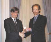
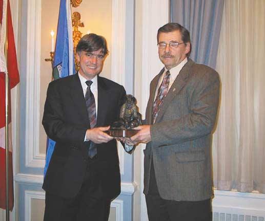
The Awards ceremony began with the presentation of the President's Award,which is given each year to an individual or organization for outstanding contributions to the Society.This year's President's Award was presented to Gerry Reinson for his work as chair of the 2002 Diamond Jubilee Convention.
The Medal of Merit is awarded for the best paper published during the previous year.This year's Medal of Merit was awarded to Kevin G.Root, author of the paper "Devonian Antler fold and thrust belt and foreland basin development in the Southern Canadian Cordillera:implications for the Western Canada Sedimentary Basin", published in the Bulletin of Canadian Petroleum Geology,v.49,no.1 (March issue),p.7–36.
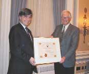
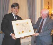
Honorary Membership is presented each year to the person,or persons,who has made outstanding contributions to the society and to the cause of petroleum geology on a national or international basis.This year's Honorary Membership acknowledged the contributions of two individuals, Ed Klovan,who has made numerous contributions to the CSPG,and Dr.Ray Yole of Carleton University.
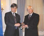
The R.J.W.Douglas Award is awarded annually for outstanding contributions to the understanding of sedimentary geology in Canada, commending major contributions to regional tectonics,petroleum,and structural geology.This year’s recipient, Dr.Graham Davies,was recognized for his vast body of work covering the complex controls on stratigraphy and diagenesis as a result of his extensive
Past President,Bruce McIntyre,presents President’s Award winner,Gerry Reinson,with his bronze statue.
Kevin Root,recipient of the Medal of Merit. Neil Ward,accepting the Honorary Membership certificate for Ed Klovan.
Ray Yole,receiving his Honorary Membership certificate.
regional work throughout the Western Canada Sedimentary Basin.
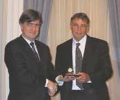
The evening ended with the presentation of the CSPG's most prestigious award,the Stanley Slipper Gold Medal.The Slipper Medal is awarded annually to an outstanding contributor to oil and gas exploration in Canada.This year's recipient was Harm Larue,in recognition of his vision in seeking new exploration trends in established areas.
Overall,the evening was a huge success,and enjoyed by all who attended.Special thanks to Douglas Carsted of Sproule Associates for organizing another successful Awards Dinner.Further thanks to our corporate sponsors Core Lab, Graham Davies Geological Consulting, Moose Oils Ltd.,Reinson Consultants, Sigma,and Sproule Associates Ltd.
Joanne Bunz,Awards Coordinator
Graham Davies,recipient of the R.J.W.Douglas Award.
Harm LaRue,recipient of the Stanley Slipper Gold Medal.
INTERNATIONAL PETRODATA LIMITED
40 years
IPL CELEBRATES 40 YEARS OF INDUSTRY LEADERSHIP
This year, International Petrodata Limited (IPL) is celebrating forty years as the industry’s leader in providing accurate wellbore data. During that history IPL has led the evolution from paper and microfilm through to fully networked solutions, and is looking forward to continuing that lead by pioneering more user friendly, integrated solutions that meet or exceed the expectations of industry professionals.
WHAT IS IPL?
IPL supplies vital wellbore data to the exploration and production business in Canada. The data is used to justify expenditures for exploration or exploitation. As one customer said: “It’s simple, we rely on data to drill wells. Without the data, you don’t know where to drill.”
retrievals and geological mapping services. Because source data matters, IPL has maintained and provided access to a comprehensive library of copies of the original source documents for all wells.
“It’s simple, we rely on data to drill wells. Without the data, you don’t know where to drill.”
Less simple though, is the technology, experience and degree of accuracy that IPL adds to the data. First, our technical experts verify and correct existing data on the original source documents before the database is created. Second, our staff of geologists pick all formation tops with unmatched consistency across the Western Canadian Sedimentary Basin. Finally, data is, in turn, delivered to clients desktops via a secure, high-speed and proven reliable online network.
THE VISION, THE PEOPLE
The vision behind IPL came in 1963 from a consortium of twelve of the petroleum industry’s major exploration and production companies. They recognized the need for an accurate, complete, and consistent source of well data.
In 1994, IPL led the industry again by creating the Petrodata Network to make the Petrodata File readily and easily available to a wide range of customers, both locally and internationally. Then in 1995, IPL formed an agreement with AccuMap EnerData Corp. to distribute the IPL data in their AccuMap software system. A new industry standard was created when IPL’s high quality wellbore data was seamlessly integrated with the AccuMap software. Today, IPL works closely with leading industry software and data partners to make our high quality wellbore data available to the market in the application and environment of the customer’s choice, whether open network systems, packaged solutions, or browser-based solutions.
A PARTNER IN EXPLORATION
IPL knows it will continue to garner customer loyalty and industry accolades by maintaining our commitment to the demands of clients for accuracy and timeliness of the data and updates; quick response to customer queries or issues, easy access by any software, and fair pricing.
IPL is more than a data vendor – we are your partner in exploration.
Some specific projects that IPL is developing at the moment include:
• Spatial enablement using Arc tools from ESRI
“Our goal is to ensure that IPL is synonymous with the most comprehensive and accurate well database available. Period.”
That vision still motivates IPL today: our goal is to ensure that IPL is synonymous with the most comprehensive and accurate well database available. Period.
The company was later acquired by Clark H. Smith, who was President and CEO until his death in 2001 and was well known throughout the industry for his commitment to excellence, customer service and the constant improvement of the IPL product. In September of that year, Tony Smith, his son, assumed the role of President and CEO, and brings new energy to a field where constant change and improvement is needed and expected by IPL’s loyal client base.
LEADING EDGE EVOLUTION
“IPL is more than a data vendor – we are your partner in exploration.”
The Petrodata File was revolutionary in that it represented the industry’s first digital data system containing basic and interpreted data for wells drilled across Canada. Initially, that data file was purchased by major oil and gas companies and maintained on their in-house computer systems. However, IPL saw the need to make the data accessible by all companies and introduced the PetroFiche System and provided custom
• New data sets, such as new information available from government sources and scanned images
• Proprietary data hosting and integration
• Integration with other software and data
Customers who want to view the future of wellbore data can test the spatially enabled version of the IPL database, which allows ESRI viewing of data using ArcView.
MESSAGE FROM THE PRESIDENT
IPL knows that customer loyalty comes through a commitment to constant improvement. At IPL, we are eager to hear from you. We would be pleased to demonstrate our latest products, and discuss how we can help your company exceed its exploration targets. Please contact Bill Carr at 263-7810.
On behalf of the IPL team, I thank the industry for 40 years of growth, and success.
Tony Smith, President and CEO, IPL
Tony Smith, President and CEO
INTERNATIONAL PETRODATA LIMITED
The Petrodata Network - The Industry’s “Open” System Solution
IPL’s Corporate Goal
IPL’s Corporate Goal
To ensure The Petrodata File is the most comprehensive and accurate database available.
To ensure The Petrodata File is the most comprehensive and accurate database available.
The Petrodata File Strengths
The Petrodata File Strengths
■ AccuracyOriginal source documents are
■ AccuracyOriginal source documents are
■ Completeness reviewed and utilized by our data technicians and analysts to create the database and ensure the accuracy and completeness of the file.
■ Completeness reviewed and utilized by our data technicians and analysts to create the database and ensure the accuracy and completeness of the file.
■ ConsistencyA network of over 800 regional cross sections are used by our geologists to ensure consistent formation tops for database searches, contour mapping and cross sections.
■ ConsistencyA network of over 800 regional cross sections are used by our geologists to ensure consistent formation tops for database searches, contour mapping and cross sections.
■ CurrencyDaily updates ensure the most current information.
■ CurrencyDaily updates ensure the most current information.
IPL Proprietary and Industry Data
IPL Proprietary and Industry Data
■ General Well Data (basic header, DST’s, IP tests, completions, porous intervals, etc.)
■ General Well Data (basic header, DST’s, IP tests, completions, porous intervals, etc.)
■ Formation Tops (correlated by IPL)
■ Formation Tops (correlated by IPL)
■ Fluid Analyses (oil, gas, water)
■ Fluid Analyses (oil, gas, water)
■ Core Analyses
■ Core Analyses
■ Directional Surveys
■ Directional Surveys
■ Grid and Culture
■ Grid and Culture
■ Production/Injection
■ Production/Injection
■ Gas Well AOFP
■ Gas Well AOFP
■ Oil Well BHP
■ Oil Well BHP
■ Reserves
■ Reserves
Vendor Partner Data
Vendor Partner Data
■ Land
■ Land
■ Pipelines/Facilities
■ Pipelines/Facilities
■ Interpreted DST’s
■ Interpreted DST’s
■ Field/Pool/Unit Outlines
■ Field/Pool/Unit Outlines
JACK PORTERVIGNETTES OF CANADIAN PETROLEUM GEOLOGY
Continued from the April Reservoir
The genesis of the bitumen associated with the McMurray Formation in the environs of the Athabasca River valley has been a contentious issue for over 120 years. However,a much better understanding of the processes involved emerged during the latter half of the Twentieth Century.Some of the salient factors that have contributed to the present understanding of its state and habitat are summarized below.
High-water marks in resolving the early controversies related to the source of the petroleum and its migration and entrapment in the Athabasca bituminous sand can be credited to a number of researchers.However,the authors of four papers in particular are worthy of mention.Evans et al (1971) theory on the role of topography-driven meteoric water having progressively biodegraded conventional oil during and following the exhumation of Cretaceous beds on the basin’s northeast flank,became the key to unlocking these longstanding contentious issues.Their concept
dispelled several previously accepted hypotheses,notably those that held the bitumen contained in the McMurray sand was inspissated petroleum,sourced from conventional oil which had escaped from subjacent Devonian carbonate reservoirs. Others had argued that the deposits were generated in situ,while still others thought that the bitumen represented an immature oil sourced from the overlying Clearwater marine shales.As shown by Creaney and Allan (1992), Late Cretaceous synorogenic loading of the basin’s foredeep,during the initiation of the Laramide orogeny,is believed to have triggered much of the progressive generation of hydrocarbons throughout the Western Canada Sedimentary Basin.
The works of Brooks et al (1988,1989) further supports Evans et al by revealing that the Cretaceous-hosted heavy oil and bitumen are very similar in organic geochemical composition.The difference between the two was determined to be largely related to the
different degrees of biodegradation.The conventional and non-conventional oil on the northeast flank of the basin is generally considered to have been principally derived from the bituminous shales of the Upper Devonian Duvernay Formation.The basal Cretaceous transgressive and diachronous sands facilitated the long-range migration of the oil generated from these older rocks. These widespread Cretaceous sands served as a conduit for the regional collection of hydrocarbons and their migration up from the southwest part of the basin.
In essence,the conventional and nonconventional crude oil deposits,as confirmed by isogravity maps,are part of a continuum, the latter crude type ultimately manifesting its own seal (bitumen of the McMurray Formation) through progressive stages of biodegradation.This “megaseal” of heavy oil and bitumen,not the host stratum,appears to have been responsible for the retention of most of the non-conventional oil reserves that
occur along the northeast rim of the basin (Porter,1992).
The up-dip limit of the bulk of these vast deposits hosted by Lower Cretaceous sands coincides with the dissolution edge of the underlying Middle Devonian salt beds contained within the Elk Point Group.This relationship appears to be no coincidence because the regional dip flattens abruptly (Max Ball’s rational for his local or in situ generation of the Athabasca bituminous sand). This change in dip probably served to suppress the transmissibility of the migrating oil,thus abetting it’s gathering en masse at its present position. The invading meteoric water provided microbes that progressively biodegraded the migrating oil and concomitantly dissolved the entire northeastern extension of these salt beds fronting the Precambrian shield (Porter,1992).
Almost 128 years have passed since John Macoun – official botanist with the Geological Survey of Canada – traveled along the Athabasca River from Fort Chipewyan on his return trip from Peace River via the Clearwater River,Methy Portage,Beaver River, and overland to Carlton House on the North Saskatchewan River (A.R.C.Selwyn,Report of
Progress,1875-76,Appendix I).His mandate was to identify existing plants and trees and evaluate the areas best suited for agricultural purposes.Being a natural scientist,yet having no formal training in geology,he nevertheless incorporated in his notes descriptions of rock exposures as well as occurrences of “tar springs” (bitumen seepages),tar sandstone, and tar conglomerate.
On a cold and rainy September 7,1875,his party stopped for dinner at an exposure of: “light grey sandstone,partly saturated with tar, and over this there was at least fifteen feet of it completely saturated” and Macoun further noted:“Where we landed,the ooze from the bank had flowed down the slope into the water and formed a tarred surface extending along the beach over one hundred yards”.The location appears to be on the east bank of the Athabasca River opposite the confluence of Tar River with the Athabasca River,some four miles south of Bitumount.During his rest following dinner,which consisted of:“Tea and dried meat of the wood buffalo,with bear’s grease to give it relish”,John Macoun records his musing in a most flowery style as he speculates about the industrial exploitation of the Athabasca bituminous sand by noting (p.170):“Long after the noise ceased I lay and
thought of the not far-distant future,when other sounds than those would wake up the silent forest;when the white man would be busy,with ready instrument,steam,raising the untold wealth which lies buried beneath the surface,and converting the present desolation into a bustling mart of trade.”
Peter Pond is credited as the first white man to cross the Methy Portage and descend the Clearwater River to reach the Athabasca River country.The year was 1778 and by doing so he “quickly discovered the fabulous riches of the fur resources” (Journal.And Letters of Sir Alexander Mackenzie,ed.,W.Kaye Lamb,1970. p.73).By viewing the bituminous sand exposures and bitumen seepages along the Athabasca and lower reaches of the Clearwater River,he had unknowingly discovered,as well,a potential energy resource of unimaginable magnitude.Some 97 years later,John Macoun was the first man to speculate on the exploitation of the Athabasca bituminous sand as an energy resource. Macoun’s prophetic vision came to fruition 92 years later when,on September 30,1967, Great Canadian Oil Sand’s Tar Island plant went on-stream to produce the first barrel of synthetic crude derived from the Athabasca bituminous sand.
To be continued ...
The 2003 Organizing Committee has been working very hard to provide Convention delegates with the most superior Technical Program and Special Events to date.Additionally, the Convention Schedule has been specifically designed to comfortably accommodate timing of events to ensure that all our PARTNERS are able to maximize their experience.
Divestco is pleased to welcome Excalibur-Gemini to our team.
We're constantly building on our ability to serve you.
PARTNERS in a new ENVIRONMENT
JUDGING AND AWARDS
The 2003 CSPG / CSEG Convention recognizes and rewards high quality presentations.Presentations are judged by panels of peers,session chairs,and randomly selected audience participation. Awards for each organizational discipline will be distributed,as well as an award for Best Integrated Paper.This category emphasizes multi-disciplinary approaches to problem solving and reflects the theme of the convention.Winners will be announced at the Core Meltdown.
Best Geological Paper
Best Geophysical Paper
Best Core Presentation
Best Student Core Presentation
Best Geological Poster
Best Geophysical Poster
Best Integrated Poster
Best Integrated Paper
Best Student Paper
Andrew Baillie Award $1000 plus plaque
Best Student Poster
Andrew Baillie Award
$1000 plus plaque
If you are interested in judging,please contact Maggie Stratton.Judging forms will also be available at all talks,poster and core sessions.
Maggie Stratton Judging and Awards (403) 231-0655
Maggie_Stratton@anadarko.com
TRENDS IN THE CANADIAN OIL PATCH
The graph at right shows the 300 significant corporate mergers and takeovers that have occurred in the upstream sector over the past 12 years.It does not include property acquisitions and counts each deal rather than the dollar value.(Source:Geo-Help’s Corporate Database).
The green bars represent Canadian companies that were taken over by foreign companies either directly – dark green (e.g., Gulf by Conoco) or subsequently – light green (e.g.,Crestar to Conoco via Gulf).
Blue represents companies that have been acquired by income trusts either directly –dark blue (e.g.,Richland to Provident) – or subsequently – light blue (e.g.,Moxie via Richland to Provident).
Red represents other acquisitions where the nationality or type of ownership is basically unchanged (e.g.,PCP and AEC to Encana or Exxon and Mobil to ExxonMobil).
In each of these 300 deals,where two companies existed before,one company exists today.Many of these predecessor companies had active exploration programs. Will the successor companies have the same interest in exploration in Canada? Will new companies evolve to fill the void? What are the implications from the change of ownership and reduced number of companies for future exploration,reserve additions,and production in Canada?
To be continued...
Foreign Subsequent (37)
Foreign Direct (34)
Trust Subsequent (19)
Trust Direct (35)
Other Mergers & Takeovers (175)
Continued from Page 22 ...
BIOGRAPHY
(Dave Russum has spent more than 25 years exploring for hydrocarbons.He recently completed an exhaustive study of Canada’s future gas supply and demand.He has developed some unique approaches to both shorten the timeframe and improve the results of exploration activities.More information can be found at www.geohelp.ab.ca
OIL AND GAS INDUSTRY
Oil sands producers face continuing pressures to reduce operating costs but trends are headed in the right direction to prevail in a soft oil market.Large Canadian independents,led by Talisman and Nexen, who have expanded their international E&P investments,also must improve results to remain competitive through the balance of this decade.
BIOGRAPHY
Dr.Pete Stark is vice president of Industry Relations for IHS Energy in Englewood,Colo.In 1969,Stark joined Petroleum Information
Corporation (PI),which is now part of IHS Energy.He has served in senior management positions in Technical Services,Technical Marketing,and International operations.Prior to joining PI,Stark was geological computing coordinator for Mobil Oil.
Stark has authored papers concerning hydrocarbon shows,horizontal drilling,U.S. natural gas productivity,industry activity perspectives,petroleum GIS/mapping,E&P databases,information management trends,and industry data standards.
BY DAVE RUSSUM
INFORMATION
This is the first in a series of snapshots of the Canadian industry designed to provide up-to-date information and give possible insights into the future of oil and gas exploration.Comments are strictly the views of the author;however,your feedback is encouraged (dave@geohelp.ab.ca).
He currently serves on the board of the Public Petroleum Data Model Association (PPDM),and was a lecturer on geologic computer applications for the AAPG Continuing Education Program.He has also served as chairman of the Alumni Advisory Board for the University of Wisconsin Department of Geology and Geophysics.Stark is a member of the AAPG, HGS,RMAG,and the Denver International Petroleum Society.In 1958,he received his B.Sc.,geology,from the University of Oklahoma and he earned his M.Sc.and Ph.D.degrees in geology from the University of Wisconsin.
Figure 1: Corporate merger and takeovers in the upstream sector
EXPLORATION AND TECHNOLOGY UPDATE LADYFERN
INTRODUCTION
Discovery of the Ladyfern Slave Point gas field in January 2000 brought in the new millennium with a high-decibel exploration boom.The field rapidly developed into North America’s largest onshore gas discovery in two decades and gave an incredible 5% boost to Canada’s total gas production.Phenomenal single-well production rates in excess of 100 mmcf/d, combined with low drilling and processing costs and immediate access to adjacent pipeline systems,made the field a powerful profit engine for industry and government.By the close of March 2002,40 wells were producing 785 million cubic feet of natural gas per day and the associated revenue stream had driven British Columbia’s oil and gas sector past forestry as the Province’s primary economic driver.With high profits came intense competition for land and reserves and a high-stakes game between competitors and partners.Innovative geological models,in combination with regional 3D seismic and aeromag programs and breakthroughs in drilling practice led to significant technical advances in characterization of Slave Point reservoirs.The legacy of the discovery has been a revitalization of Canadian wildcat exploration as companies of all sizes compete to find the next Ladyfern.
PLAY DEVELOPMENT
Deep exploration in the Ladyfern area began in 1974 when Elf Aquitaine drilled a wildcat test well (10-13-94-13W6) that encountered limestone with a small amount of porosity in the Slave Point Formation.The well tested gas and water from the underlying Gilwood sandstone and was declared dry and abandoned.Although economically unsuccessful,the well did prove up the presence of carbonate banks and this was enough encouragement to justify two further attempts to find the porous bank margin by Gulf Canada in 1991 (6-34-9412W6) and PanCanadian Petroleum in 1994 (3-31-94-12W6).Both of these wells recovered tight basinal limestone.The high carbonate content of the offbank strata made seismic imaging of the bank edge virtually impossible with existing data and,as a result,no further wells were drilled for several years. Industry exploration efforts shifted further to the north and east where higher basinal shale content and better acoustic impedance contrasts between reservoir and nonreservoir rock resulted in numerous discoveries of small Slave Point “islands”.
Shell Canada entered the Ladyfern area in 1997 with the establishment of the experimental Plains Exploration Group – a small entrepreneurial company designed to more efficiently compete with the successful startups of the day.Analysis of existing core and 2D seismic data from the Ladyfern area indicated a carbonate bank margin,significant faulting, fractures,and – most importantly – traces of hydrothermal dolomite.Extensive reprocessing of the 2D seismic data resulted in a rough bank edge interpretation with an east / west orientation which led,in turn,to the shooting of a 72-square-mile 3D spec survey with Response Seismic Ltd.in the winter of 199899.The 3D confirmed a closed bank edge, extensional faults,and collapse synclines,similar to those imaged by a template 3D seismic program over the best wells in the Hamburg main pool.Land was strategically posted over the a-97-H/94-H-1 discovery location,a-61H/94-H-1 collapse syncline,and other bank edge locations.
In April 1999,the “South Bank” farm-in opportunity was shown at the CAPL Prospect Expo (to companies that signed a confidentiality agreement) in an effort to bring outside capital to the play.One month later,Shell Canada Ltd. made a corporate decision to focus on frontier plays and announced that all of their Plains assets were for sale.No money would be forthcoming to buy the Ladyfern acreage or to drill the prospect.In August,Murphy Oil Corp.and Beau Canada Exploration Ltd.farmed in for 33% and 30%,respectively.Although Shell’s Plains Exploration Group held a controlling 37% in the play,lack of budget and an uncertain future dictated that operatorship be surrendered to Murphy Oil.In December 1999,Apache Canada Ltd.bought Shell Canada’s Plains exploration unit – Ladyfern prospect and exploration team intact.One month later,Murphy Beau Shell Ladyfern a-97-H/94-H-1 lost circulation at 2,800 m in the Slave Point Formation and Ladyfern kicked back with a high rate of gas.
Production testing indicated dry,slightly sour gas (5 ppm H2S,4% CO2) with a reservoir pressure of 4,400 psi and a tremendous deliverability of 100 mmcf/d.Three other wells were drilled to determine the extent of the discovery while 25 kilometers of 8-inch pipe was installed to join the a-97-H well to Apache’s Hamburg gas plant. As work continued into the spring,fifteen additional sections of offsetting land were acquired through land sales and farm-in.
RESERVOIR DEVELOPMENT
A basement strike-slip structural regime associated with the Hay River Fault Zone controlled areal distribution patterns of reservoir facies in the Slave Point Formation at Ladyfern and directly influenced architecture and cyclicity.The Ladyfern Slave Point platform covers an area in excess of 100 square kilometres.The trap is stratigraphic/diagenetic and a seal is provided laterally by tight Slave Point argillaceous limestones and above by Beaverhill Lake shales.A general thinning of the Slave Point to Muskeg interval occurs across the Ladyfern bank and the area is coincident with a strong aeromagnetic anomaly that suggests a prominent basement “high”.Slave Point carbonate platform nucleation occurred above this positive feature.Major bounding faults parallel the edges of this aeromagnetic anomaly and are coincident with the development of the Slave Point bank margin.Variations within the Slave Point across some faults suggest syndepositional tectonism and synsedimentary changes in accommodation space.
Seismically,the Ladyfern bank has a strong amplitude reflection at the top of the Slave Point.In contrast,trapping basinal strata have a relatively diminished amplitude response and an areally extensive lower Slave Point amplitude peak caused by a five-meter-thick shale bed.Porous bank areas have variable seismic signatures controlled by local stratigraphic and structural heterogeneities.
Internal Slave Point stratigraphy records three cyclic phases of deposition.The carbonate complex evolved from an extensive open marine stromotoporoid bank into a restricted lagoon and shoal system that became increasingly open marine in the final phase of deposition.
The dominant reservoir unit in the field is a 15-20 m thick basal platformal dolomite. Core,thin section,and FMI data indicate that this stromatporoid packstone was preferentially dolomitized,fractured,and leached during burial,resulting in porosities up to 30% and maximum permeabilities in excess of one darcy.As a result,there is extremely good communication between most wells that produce from this zone.
In addition to the basal platform unit,the northern margin has middle and upper grainstone shoal units that locally contribute
THOMAS BOREEN, Ph.D., P.Geol., KELVIN COLQUHOUN, P.Geoph.
up to 30 m of additional limestone reservoir. The deliverability of this reservoir is considerably less however,with porosities averaging 5-6% and permeabilities from 0.120 md.Bank margins are slightly thickened locally and the best porosity appears to be in a rimming zone approximately 300 m wide.In contrast,in the lee of the shoal complex to the south and west,the upper two units are nonproductive,tight,lagoonal limestones.
Thin-section analysis indicates a complex diagenetic history.At Ladyfern,calcite burial cements largely occluded primary porosity. Reservoir quality was restored by secondary hydrothermal dolomitization and dissolution. This secondary porosity is areally associated with zones of extensional faulting that crosscut the carbonate bank.Episodic reactivation of faults has resulted in extensive fracturing of the Slave Point bank and created conduits for hydrothermal fluids,which have variably leached,dolomitized,and cemented the rock.
In areas of maximum extension proximal to fault intersections,intense dissolution, brecciation,and hydrothermal dolomitization have resulted in seismically resolvable collapse synclines at the Muskeg and Slave Point levels (Fig.1).The thickest and best reservoir sections (e.g.,a-97-H/94-H-1 and a61-H/94-H-1) are directly associated with these “collapses”.Increased vertical permeability related to these dissolution pipes provides local conduits for fluids to rise and enter stratiform reservoir units in the lower Slave Point platform and upper Slave
Point bank.The intensity of the secondary diagenetic overprint and the resultant variability in reservoir quality is directly related to original rock fabric and proximity to the extensional zones.Two major phases of strike-slip faulting are apparent in the Slave Point and older strata.Collapse synclines occur along some faults in a “string of pearls” configuration and also in proximity to fault intersections.These collapses can occur in basinal facies as well as on the carbonate bank,and thus not all collapse features are associated with dolomitized reservoir rock.
COMPETITION
On February 17,2000,the Ladyfern discovery was announced in the Daily Oil Bulletin and in April 2000,the a-97-H well came on production at an allowable limit rate of 47 mmcf/d (discovery drilling to sales delivery in less than six months).
Offsetting land holders Alberta Energy Ltd. (13,360 ha) and Canadian Natural Resources Limited (12,140 ha) immediately jumped into the play with new deep-exploration teams (Fig.2).Land-sale prices skyrocketed from $800/ha to $15,000/ha as Ricks Nova Scotia Co.and Predator Energy paid record prices for lands offsetting the a-97-H discovery well. Murphy Oil expanded its position in the play to 63% by acquiring Beau Canada.
In an effort to ensure rapid tie-in of their anticipated gas wells,Ricks Nova Scotia Co.and Predator Energies Partnership,applied for an NEB permit to build a $3 million,12-kilometre
pipeline to cross the B.C.border and link into the Nova-TransCanada grid in Alberta.
Murphy Oil Company Ltd.,Apache Canada Ltd.,and Murphy Canada Exploration Ltd.filed a statement of claim against the Predator Corporation claiming that the Predator group “surreptitiously and illegally” obtained confidential information about the a-97-H/94H-1 discovery well,which was to remain confidential until February 1,2001.Murphy and Apache claimed that the Predator group used trade secrets and confidential information to gain a business advantage, acquiring nearby land in B.C.Crown land sales to capitalize on the information they had obtained.Ricks subsequently bowed out of Ladyfern,selling its 75% interests in the lands in question to Murphy and Apache at cost.The Predator Corporation responded with its own counterclaim against Murphy Oil Company, Murphy Canada Exploration,and Apache Canada.Predator alleged Murphy set out to destroy its business,and is claiming compensatory damages (Daily Oil Bulletin,Feb 12,2001).Both claims remain before the court.
The 2000 / 2001 drilling season saw an explosion of activity.Murphy Oil,CNRL,and AEC (now EnCana) shot extensive 3D seismic programs.Apache / Murphy drilled 15 wells and constructed a gathering system,dehydration facility,and a 37-kilometer,12-inch pipeline loop from the dehydration facility to Apache’s newly expanded Hamburg gas plant.
EnCana licensed 10 locations on the southern Ladyfern margin and introduced PDC bits and underbalance drilling technology to the play with impressive results.The wells went down with exceptional speed and safety and enabled better logging runs,core recoveries,and production tests.EnCana executed their program with incredible proficiency,proving production of 150 mmcf/d,acquiring Predator’s NEB rights to build a pipeline across the border,constructing onsite facilities,and getting four high-rate gas wells on production by spring 2001.Both CNRL and Predator were rewarded with high-volume wells on the northern bank margin offsetting the a-97-H discovery.CNRL continued to drill a series of successful wells into the summer in an effort to minimize the effects of drainage by offsetting wells.The downdip water leg of the field was defined by both CNRL and EnCana.
By June 2001,three pipelines connected the discovery to the North American grid,each with an average daily capacity of about 170 mmcf/d and by the end of the year,contribution from the 12 producing wells at Ladyfern made up 500 mmcf/d of North America’s total incremental production for the year.The other
Figure 1: 3D seismic display showing fault intersections and offsets across the Slave Point bank margin at Ladyfern.
12,000 gas wells drilled on the continent combined added less new production than Ladyfern alone (First Energy Capital Corp.).
The race to capture reserves resulted in unprecedented expenditures.Although individual wells were capable of draining extremely large areas,every spacing unit adjacent to competitor land received a well. CNRL drilled through the summer using helicopters to transport rigs and support equipment into the muskeg.Murphy and CNRL individually put in all-weather roads. Murphy / Apache,CNRL,and EnCana each installed their own processing facilities and takeaway lines.Each company added compression to ensure their pipelines remained at capacity.In less than a year,$400 million (Oil and Gas Investor,06/02) was spent on drilling and infrastructure in the Ladyfern field.During the spring and summer of 2001,the major players EnCana,CNRL, Apache,and Murphy entered into a production-sharing arrangement to allocate the existing and planned take-away capacity.
Ongoing development drilling programs have continued in the Ladyfern field through 2003 and significant reserve additions are still being made,if at a somewhat diminished pace.The Ladyfern Slave Point gas field has produced 340 bcf to date and published recoverable
reserve estimates range between 500 bcf and a trillion cubic feet.
The phenomenal deliverability of the Ladyfern field made rapid decline inevitable.Early this year,output from the field peaked at over threequarters of a billion cubic feet per day and began to descend.The field’s overall lifespan is expected to be less than 10 years.With the tremendous expansion of TransCanada’s takeaway capacity in the Ladyfern area,from 1.8 bcf/d to 2.75 bcf/d there is a strong exploration effort underway to replace the soon-to-bediminished Ladyfern production.
EXPLORATION EXPANSION
Immediately following the discovery at Ladyfern,exploration focus expanded outward from the play.Land sale activity continued along trend to the west and north of Ladyfern. Numerous Slave Point wildcat wells have been licensed across the sparsely drilled Hotchkiss Embayment and new discoveries have been announced at Buick Creek,Dahl,Foxglove, Adsett,and Bubbles.Much of the southwestern margin has been carpeted with 3D seismic grids and most recently the play has extended eastward into Alberta,south of the prolific Hamburg and Cranberry fields where dolomite and gas shows indicate potential in another area of low drilling density and limited seismic data – very similar to Ladyfern four years ago.
BIOGRAPHY
Thomas Boreen is a senior exploration geologist at Suncor Energy Prospect Generation Services in Calgary,Alberta.He started his career in oil and gas as a battery operator for Husky Oil Operations in 1981 and received a B.Sc.Honors in Geology from the University of Saskatchewan in 1987,a M.Sc.in clastic sedimentology from McMaster University in 1989,and a Ph.D.in carbonate sedimentology from Queen’s University in 1993.Since graduating,Dr. Boreen has worked as an exploration geologist and technical advisor for a number of international oil and gas companies including Home Oil Company, Anderson Exploration Ltd.,Shell Canada Ltd., Apache Canada Ltd.,and Suncor Energy PGS.He has published numerous technical papers and has received CSPG awards for Outstanding Ph.D.Thesis (1995),Link Award for outstanding technical presentation (1996),and CSPG Best Core presentation award (2002).
Kelvin Colquhoun is a senior staff geophysicist at Apache Canada Ltd.in Calgary,Alberta.He graduated with a B.Sc.in Physics from Brandon University in 1990 and was trained and employed as a geophysical processor and interpreter by Shell Canada from 1987 to 1999.Since joining Apache Canada Ltd.in 1999 Kelvin has been instrumental in the discovery of numerous high-impact Slave Point oil and gas pools in northeast B.C.and Alberta.
Tom Boreen and Kelvin Colquhoun’s paper on Ladyfern is the second of a series of articles published in the CSPG Reservoir under the new “Exploration and Technology Update” section.Reservoir readers are encouraged to submit short articles that focus on new exploration ideas or technological advances that are relevant to petroleum exploration in Canada.
We are currently looking for articles on the following subjects:
1)very shallow gas plays in the WCSB (i.e.,Quaternary,Edmonton,Bluesky,etc.); 2)hydrocarbon potential of the Mackenzie Corridor; 3)coalbed methane plays in the WCSB;and 4)the remaining frontier of the fold and thrust belt in northeast B.C.
We also plan to publish your comments and suggestions on previous articles.
Your contributions should be sent to Zeev Berger (tel:[403] 216-1845) by email at zeev@iitech.ca.For document format details, please see the Guidelines for Authors published in the CSPG Bulletin or contact one of the Reservoir’s editors.
Figure 2: Ladyfern gas field map showing cumulative gas production bubbles and infrastructure.
GNEISS N’ LITE - HUMOR FOR THE GEOLOGIST
In recent columns of Gneiss and Lite we have begun recycling past material – so,to continue with this trend,here is a compilation of ‘merger mania trivia’ for you to digest.All of the following have appeared in this column over the past few years.You may notice that some of these companies have already merged, however,not with the same combinations that had been suggested by yours truly.
• If Imperial,Magin,and Union merged,the resulting entity could be called Imagination.Now,that would take a lot, of imagination,that is!
• If Alberta Energy and Sigma merged,we could have an Alberta Enigma (maybe it already is,an enigma,that is!) Maybe this could compete with the ‘Alberta Advantage’!
• If Star and Rife were to join,the result might be Strife – or maybe it already is??
• A merger of Denison Mines,Alliance,and Newmont Mining could create a new company called Mine All Mine.
• A merger of Honeywell,Imasco,and Home Oil would end up being Honey,I’m Home
If Esso and Gascan joined,would you end up getting a Tiger in your Gascan instead of in your tank?
• If John Deere and Abitibi-Price were to merge,you would end with ‘Deer Abi’.
• If Beau Canada and Derrick Energy teamed up,I’m willing to bet all the guys would want to work for Bo Derrick!!
• If Cabre and Sabre merged,would you like to labor at Cabre/Sabre?
• Would a joint company of Dapper Resources and Danoil employ a staff of Dapper Dans?
• How about 3M and Goodyear –mmmGood!
• A merger of Knott’s Berry Farm and the National Organization of Women would likely mean Knott NOW!
• If Maximum Energy,Maxwell O&G,and MAXX were all to merge,you’d be sure to get Max-Max-Max or Max3
• If Canada Northwest Energy and Passage Energy were to merge,maybe someone could find that all elusive ‘northwest passage’!
BY BOB ROBSON
• If Fox Resources merged with Hunt Oil we could go to England on a Fox Hunt
• If Blackrock Ventures joined up with Forest Oil,we could go to Germany and visit the Black Forest.
• If Emerald Bay Resources and Glen Isle Exploration teamed up,we could go to Ireland to see the Emerald Isle
• If Exxon,BP,and Royal Dutch Sell were all to merge…there’d be…one darn big oil company!!
• If Empire Energy,Strike Resources,and Backer Petroleum all merged,you’d get Empire Strikes Back – now,would that be the sequel or the prequel?
Okay,here comes the test – how many of the above companies have actually merged in the past few years? How many are left? If you have any hair-brained ideas of possible mergers for the oilpatch,or any other ideas of geological humor or trivia,I’d love to hear from you.Send your contributions to bob.robson@shaw.ca
Geomodeling Technology Corp (GTC) is a world leader in providing seismic attribute interpretation and 3D reservoir modeling software to the oil industry.
Our R&D partners and clients include major international oil companies, such as Agip Petroleum, BG International, ExxonMobil, Norsk Hydro, Shell International, Statoil, TotalFinaElf, and a fast-growing Calgary client base.
Dr. Renjun Wen founded GTC in November 1996, after he immigrated to Calgary from Trondheim, Norway, where he had obtained his PhD degree in Petroleum Geology from the Norwegian University of Science and Technology. The corporate head office is located in Calgary, Alberta and employs fifteen people. International offices are being planned in Beijing, Houston, and Oslo.
Since 1996, GTC has been developing seismic attribute processing, interpretation, visualization and advanced geological modeling software with its R&D partners.
GTC has three software packages commercially available to non-sponsor companies. They are PIXAT™, VISUALVOXAT™, and SBED™.
With this unique software and technology, GTC also provides consulting services to oil companies.
We would like to thank our R&D partners and clients for their support.
Don’t just take it from us, read what one of customers has to say:
“SBED™ has become an important tool in reservoir characterization. We have successfully used SBED™ to estimate effective permeability, especially KV/KH ratios in highly heterogeneous reservoirs”.
Dr. Philip Ringrose Technical Advisor Statoil, Norway
Agip Petroleum
Providing solutions for fully integrated seismic attribute analysis, interpretation, visualization and geological modeling.
TM
• Seismic Interpretation beyond Horizon Picking.
• 3D seismic attribute analysis and interpretation for reservoir characterization.
• Enable users to extract valuable structural and stratigraphic information from seismic data before or after horizon picking.
• Integrated environment for visualizing multiple attribute volumes, horizons, well logs and reservoir grids.
• Seismic facies classification using neural networks and waveform correlation.
• Geobody detection.
• Bridging the scale gap between geology, geophysics & reservoir engineering.
• A revolutionary reservoir geological reservoir-modeling tool.
• Major objective is to solve “cross-scale” problems between cores, well-log, seismic images and well test data.
VisualVoxAt
SBED TM
Saturation Modeling
A great leap forward in integrated reservoir characterization
Geo2FlowRMS is the essential saturation modelling tool. The past decade has seen vast improvements in the 3D modeling of facies, porosity, and permabiity. Geo2FlowRMS connects all of this to the accurate calculation of fluid distributions. After all, oil and gas are what we bring to the marketplace. Geo2FlowRMS answers the critical questions: "How much?" and "From how many flow units?"
The main benefits with Geo2FlowRMS are:
More accurate volumetrics
Improved delineation of reservoir compartments
Better identification of oil and gas for infill drilling
Physically realistic 3D saturations
Faster cycle times in preparing consistent reservoir models for flow simulation and history matching
Integration
Geo2FlowRMS brings reservoir teams together. It links petrophysics, geology, geophysics, and reservoir engineering in a software environment that fosters interdisciplinary communication. It will help your team to:
Qualiy control log measurements
Relate stratigraphy and lithology to J functions
Quantify the sealing capacity of faults
Tie porosity inversion of seismic data directly to fluid distribution
Improve measurements or correlations of permeability
Ensure that static and dynamic models attain the same initial saturations
The key to Geo2FlowRMS is a patent-pending method for intepreing log derived Leverett J functions within the context of 3D geological models. Geo2FlowRMS is tightly integrated with Irap RMS through RMSopen. Both inputs and outputssuch as raw and blocked well data, zone and fault segment descriptors, 3D parameters, and fluid contact grids - are directly read or written to your RMS model.
Summary
Geo2FlowRMS coupled with the unrivalled power of RMS, is truly a great leap forward in integrated reservoir characterization. It is developed by O'Meara Consulting, Inc. and is marketed exclusively by RoxarSoftware Solutions. To learn more about Geo2FlowRMS visit: www.geo2flow.com.
Get an update on the State of the Art of 3D reservoir modeling at the Roxar Canada User Conference at Marriott Downtown Calgary, Tuesday, 6 May 2003
Figure 1: Oil saturation in six reservoir compartments