■ Earth Science Education: A Unique Approach Inside and Outside the Classroom
■
■ 2003 CSPG / CSEG Convention: PARTNERS in a New ENVIRONMENT
■ Net Pay in Naturally Fractured Reservoirs
■ Net Pay in Naturally Fractured Reservoirs
■ Preliminary Tectonic Map of the Western Canada Sedimentary Basin
■ Preliminary Tectonic Map of the Western Canada Sedimentary Basin
CSPG OFFICE
#160,540 - 5th Avenue SW
Calgary,Alberta,Canada T2P 0M2
Tel:403-264-5610 Fax:403-264-5898
Email:cspg@cspg.org Web:www.cspg.org
Office hours:Monday to Friday,8:30am to 4:00pm
Business Manager:Tim Howard
Email:tim.howard@cspg.org
Office Manager:Deanna Watkins
Email:deanna.watkins@cspg.org
Communications Manager:Jaimè Croft
Email:jaime.croft@cspg.org
Conventions Manager:Lori Humphrey-Clements
Email:lori@cspg.org
Corporate Relations Manager:Kim MacLean
Email:kim.maclean@cspg.org
EDITORS
Please submit RESERVOIR articles to the CSPG office.Submission deadline is the 23th day of the month,2 months prior to issue date. (i.e.,January 23 for the March issue).
To publish an article,the CSPG requires digital copies of the document.Text should be in Microsoft Word format and illustrations should be in TIFF format at 300 dpi.For additional information on manuscript preparation,refer to the Guidelines for Authors published in the CSPG Bulletin or contact the editor.
COORDINATING EDITOR & OPERATIONS
Jaimè Croft
CSPG
Tel:403-264-5610 Fax:403-264-5898
Email:jaime.croft@cspg.org
TECHNICAL EDITOR
Ben McKenzie
GEOCAN Energy Inc.
Tel:403-261-3851
Email:bjmck@telusplanet.net
ADVERTISING
All inquiries regarding advertising and technical specifications should be directed to Kim MacLean.The deadline to reserve advertising space is the 23th day of the month,2 months prior to issue date.All advertising artwork should be sent directly to Kim MacLean at the CSPG.
The RESERVOIR is published 11 times per year by the Canadian Society of Petroleum Geologists.This includes a combined issue for the months of July/August.
Advertisements,as well as inserts,mailed with the publication are paid advertisements.No endorsement or sponsorship by the Canadian Society of Petroleum Geologists is implied.
The CSPG Rock Shop is an attractive and affordable way for advertisers to present their services to the CSPG Readership.Spaces are sold at business card sizes (3.5” wide by 2” high) and will eventually fill an entire Rock Shop page. For more information or to book a space please contact Kim MacLean at 403-264-5610,ext.205.
The contents of this publication may not be reproduced either in part or in full without the consent of the publisher.
ARTICLES
DEPARTMENTS
Design & Layout by McAra Printing
THE CSPG GRATEFULLY ACKNOWLEDGES ITS *CORPORATE MEMBERS:
ABU DHABI OIL CO., LTD. (JAPAN)
ARCHEAN ENERGY LTD.
BURLINGTON RESOURCES CANADA ENERGY LTD.
CALPINE CANADA
CANADIAN FOREST OIL LTD.
CONOCOPHILLIPS CANADA RESOURCES LIMITED
DEVON CANADA CORPORATION
DOMINION EXPLORATION CANADA LTD.
ECL CANADA
EL PASO OIL & GAS CANADA, INC.
HUNT OIL COMPANY OF CANADA, INC.
IHS ENERGY
IMPERIAL OIL RESOURCES LIMITED
LARIO OIL & GAS COMPANY
MJ SYSTEMS
MURPHY OIL COMPANY LTD.
NCE RESOURCES GROUP INC.
NEXEN INC.
NORTHROCK RESOURCES LTD.
PENN WEST PETROLEUM LTD.
PETRO-CANADA OIL AND GAS
SAMSON CANADA
SHELL CANADA LIMITED
SPROULE ASSOCIATES LIMITED
SUNCOR ENERGY INC.
TALISMAN ENERGY INC.
TOTALFINAELF E&P CANADA LIMITED
UPTON RESOURCES INC.
*CORPORATE MEMBERS AS OF APRIL 24, 2003
MEMORIAL ANNOUNCEMENT Dr. S.J. Nelson
Dr.Samuel James Nelson,P.Eng.,P.Geol.,Professor Emeritus,University of Calgary,a prominent Canadian geologist,died in Victoria,British Columbia,on February 19,2003 of cancer.Dr.Nelson received his Ph.D.in Geology with Great Distinction from the University of McGill (1952).He published extensively, including several books on the geology of Western Canada.He was well known to the oil industry having taught at the University of Calgary,the University of Alberta,and the University of New Brunswick.Amongst other publications,Dr. Nelson was best known for authoring “The Face of Time”,a geological history of Western Canada,used as a reference guide by the oil industry.
Dr.Nelson served the Canadian Society of Petroleum Geologists as Secretary, 1968 – 1969;Director,1970 – 1971;Chairman,Research & Graduate Student Awards Committee,1968 – 1971;and Representative on Advisory Council to Alberta Research Council,1968 – 1971.
During his distinguished career as a scholar,educator,and author,he received awards including those from the Student Legislative Council,Faculty of Science, University of Calgary for Distinction of Superior Teacher and from the Canadian Society of Petroleum Geologists for distinguished service to the field.
I just returned from a rewarding experience:giving lectures at a number of universities in Ontario and Manitoba on what a geologist does in the petroleum industry.This Outreach Lecture Tour was one of three launched this spring as a part of the CSPG Educational Trust Fund (ETF) University Outreach strategy put in place by a committee chaired by Brad Hayes. The students’ feedback,enthusiasm,and interest convinced me that the outreach effort is very worthwhile,so I thought I’d tell you about my tour and highlight some of our Society’s other student outreach activities for this editorial column. Consider this also an enthusiastic plea to give more students the chance to show what they can do in our industry.
LECTURE TOURS
Lecture tours are one way to put a personal face on the CSPG as well as to communicate information about our industry to universities.The winner of the Link Award (best CSPG Technical Luncheon talk),and speakers recruited from the CSPG membership agree to donate their time,and are sent to schools across Canada.The ultimate goal is to address each geology department once a year.This year,three speakers were sent out in the spring on Outreach tours,and another group of four lecturers are going out in the fall to visit a total of 24 universities.There are several reasons the CSPG and ETF jointly sponsor these Outreach tours.One is to encourage students to consider a career in our industry by showing them that it can be challenging,high tech,and diverse. Another is to coach them on how to find a job in the industry.A third reason is to
A MESSAGE FROM THE FINANCE DIRECTOR
listen to the students’ feedback and to answer questions;to open lines of communication.There are 30-60 students and faculty at each talk - enticed by the promise of free pizza.
Feedback and questions from the students at my lectures ranged from career-related questions (“What were the toughest challenges you faced as a woman in your career?” – yikes!) to questions on very practical,job-finding issues.The job-finding questions were the hardest to answer encouragingly,even though our profession faces a huge demographic-fueled crash over the next 10 or so years.For students, summer jobs are certainly the best way to get some experience and make industry contacts.Although students are interested in jobs in Calgary,it is hard to identify opportunities from outside the province and outside the industry (aside from increasingly rare on-campus,largecompany-sponsored interviews).Certainly, the prospect of traveling to a new city many kilometers away and at considerable expense just on the chance of getting a job is daunting.
From an employer’s point of view,there isn’t a lot of incentive for hiring inexperienced professionals,and,let’s face it – they do require extra precious time and effort to train.What a short-sighted perspective! Long term,these students are the lifeblood of our profession.As I see it,there are two basic challenges to bringing more young professionals from across Canada into our industry.One is communication.Can we make it easier to let more students know of summer jobs and to quickly connect employers with job candidates? Our annual CSPG convention is probably the best venue for bringing students and employers face to face.At the annual Calgary convention, university-campus housing,alumnistudent functions,interview rooms,and job boards could all be focused toward attracting students from across Canada. Unfortunately,many university students I spoke with weren’t aware of when or what our convention is – and the timing is last minute for a summer job.
Another approach to improving communication is an online student
Donations of $5000+
Alberta Energy Company Ltd.
Andrew Baillie
William A. Bell
Conoco Canada Ltd.
Donations of $1000+
Apache Canada Ltd.
APEGGA
D.L. Barss
Ted Best
BP Amoco
Charles and Sandra Buckley
Tony Cadrin
C.K. Caldwell
Canadian Occidental Petroleum
Continental Laboratories (1985) Ltd.
Decollement Consulting Ltd.
Robert H. Erickson
Harley N. Hotchkiss
Sproule Associates Ltd.
Darol J. Wigham
Anonymous Donors: 2
John A. Downing
George Grant
Andrew Holder
Husky Oil Operations Ltd.
Ian Hutcheon
Jack Gallagher Fund
Tako Konig
Keith A. Lowell
Mike Ware Memorial Fund
Murphy Oil Company Ltd.
Alice Payne & Allin Follensbee
Petro-Canada Oil & Gas
Donations of $500+
John Andriuk
S.A. Antoniuk
Belloy Petroleum Consulting Ltd.
Philip R. Brown
Cabre Exploration Ltd.
Canadian Hunter Exploration Ltd.
M.A. Carrigy
Barney Clare
Roger N. Dueck
Andy Evans
Brian F.G. Fischer
Paul Gagnon
R.P. Glaister
Gerald Henderson
Don Holmes
Dave Hutchinson
Mike Hriskevich
Jenik Consultants Inc.
Alan R. and Faye Keevil
Emmanuel Malterr
D. Keith MacDonald e Mancal Energy Inc.
Monica Meding
MJ Systems
François A. Montandon
Arne R. Nielsen
Donations up to $499
C.H. Acheson
Shaun E. Alspach
John Ambler
John Andrichuk
Grey H.M. Austin
Denis F. Bacon
Andr
eas Bayer
Lorraine Beaupre
Tim Bird
Thomas Boleantu
Fred G. Rayer
Kathryn Scales
Des Smith
Charles Stelck
Uldis Upitis
Irmgard Weihmann
Harry Woodward
Anonymous Donors: 6
Brian Norford Reeves Wireline
Rozsa Petroleum Ltd.
Samson Canada Ltd.
John Wall
Charles Wright
Anonymous Donors: 12
James A. Genereux
R.N. Ginsburg
V. Richard Green
Indraman Halim-Dihardja
Syed M. Hasan
Brad Hayes
Clifford Herman
Denise Hodder
W. Gordon Holland
Ernest C. Horvath
Tim Howard
John M. Br
Simon L. Brame owning
Finley Campbell
James E. Christopher
Barney Clare
Dean Clemenson
Canada Post Corporation
Cor Murrary F.J. Cooper
excana
Steve S. Cosburn
Davis MPE, Inc.
Judy & Jodi Hughes
J. Jansonius
Bertram B. Jarrett
David Johnston
Paul A. Johnston
Donald M. Kent
Aubr
ey Kerr
Jim Kirker
Ian K. Kirkland
Sharna Laven
Donald C. Lawton
William G. Dean
Alice Desr
James E. Day ocher
Rein DeWit
James A. Dolph
Drummond Consulting
John L.J. Duhault
Gr
eg M. Dyble
David Erickson
Arthur Evans
Myron D. Franks
Paul Fuenning
Richard C. Galloway
Garuda Resources
Geo-Help Inc.
Patricia Lee
S. Leggett
C. Derek Lester
Wilfred Loucks
Bruce Lyon
Kim MacLean
Robin Mann
David Q. Martin
Barry Mazurkewich
R.C. McCasland Jr.
Margaret MacIntyre
Keith A. McAdam
G. Rae Mor
Ronald M. Misko gan
Coleman W. Morton . Mountjoy
John G. Stout
Eric W
Daryll Myhr
Charles Newmarch
Northstar Energy
Godfrey Nowlan
Karl Olson
R.G. Oicle
Vic Panei
D.J. Parker
Kevin Parks
June & Merv Pedlow
Steven W. Perry
Mitchell L. Peters
Ken Potma
Ray Price
Mrs. J. Purvis
Mr. & Mrs. H. Purvis
S. Silver Purvis
Peter E. Putnam
Indraneel Raychaudhuri
Cindy Riediger
Frances K. Roessingh
Christopher E. Ruud
Lisa Sack
Katherine Sammons
James Scott
Chris Sigvaldason
Philip S. Simony
Claus Sitzler
Scott R. Smith
Brad Spence
Michael S. Stanton
Chris Steudler
John Stobart
Donald Stott
Roy A. Stuart
Suncor Ener
Gerald W. Sullivan gy Foundation
Neil Theissen
Sato Toshiaki
Jens F
Clinton Tippett . Touborg
John Townley III
John Valent
Christian Viau
ed Watchuk
T R.S. Vogan
Craig G. Wiebe
Edwin Williams
Ulrich Wissner
Gor
don Williams
John S. Wonfor ood
Barry W
Brenda Wright
Dale A. Wright
Colin Y
G.C. Yamada eo
Ray Yole
Philip M. Young
Anonymous Donors: 79
EXECUTIVE
BULLETIN DONATIONS
A MESSAGE FROM THE FINANCE DIRECTOR
The CSPG is once again seeking donations of past issues of the Bulletin of Canadian Petroleum Geology.Our digital archiving project is progressing and we are now seeking Bulletins dated prior to 1976.It is our desire to put together three sets of journals for shipping to our project partners at AAPG Datapages.Watch the Reservoir for more information on this project and when you will be able to access digital articles online.
If you are able to make a donation,please contact Jaimè Croft,Communications Manager, at (403) 264-5610,ext.203 or jaime.croft@cspg.org.
COMING IN JULY…
resume service.A jobsite on the CSPG website which will allow students to post resumes,and corporate members to then browse them,will be functional by the time you read this editorial.
The second challenge is to make hiring summer students more attractive to small businesses.Would a 1- or 2-day seminar associated with the convention, and covering land sales,lease continuations,basic log interpretation, and the basics of an industry software package like Accumap allow 3rd and 4th year students to contribute immediately on the job? It’s worth a trial.
SIFT
The annual Student-Industry Field Trip (SIFT) is one of the flagships of the Outreach committee,and,like the Outreach Tours,it is sponsored by the ETF.This long-running program includes a field trip,rig tour,lectures,core workshops,and most importantly,an “exploration game” for approximately 30 university-nominated 3rd-year students. The trip attracts some of the best geology students from across Canada.It initiates long-lasting friendships,and has launched many careers.The drawback is that only one student a year from each Canadian university gets access to this opportunity.There are opportunities for volunteers and corporate sponsors to become involved in SIFT.
CORPORATE PARTICIPATION
technical talks and an information booth disseminate information about our industry and the Society.
STUDENT MEMBERSHIPS
Although student memberships is the CPSG should be an excellent vehicle to inform students of the CSPG and the petroleum industry,at least one student confided to me that there was “…nothing in the Reservoir but a bunch of old farts and inaccessible talks” (ouch!).The Outreach Committee has several strategies in mind to make the CSPG more attractive to students,but we face the promotional challenge of making our publications and memberships relevant to an ’outsider’.
SCHOLARSHIPS, AWARDS
Regional awards and scholarships are given annually to graduate and undergraduate students to promote advanced education and research,and to recognize the contribution of research to sedimentary and/or petroleum geology. The winners of these awards are recognized in the Reservoir.The focus is toward recognition within our geological community rather than promotion of the CSPG and ETF within the universities.
Watch your July/August issue for the results of the 2003 Membership Survey. Find out what you and your fellow members really think about the Society and its programs!
The Outreach Committee recognizes the need to link up industry companies and students.This is the first stop if your company is considering hiring students, donating educational material (cores, logs,cuttings),or funding university-level research projects.
UNIVERSITY CONFERENCES
To paraphrase the words of an old adage,“If Mohammed can’t come to the mountain…let the mountain come to Mohammed”.In this case,if the ETF is the mountain,it does participate annually in regional university conferences like the WIUGC and the AUGC,and the ETF is open to supporting other studentsponsored meetings.Financial help, prizes,and trophies are available,while
Geology students graduating from universities outside Alberta are often unaware of opportunities in the petroleum industry.Our current glut of baby-boomers will start leaving the workforce soon,leaving few replacements. Encouraging and mentoring young professionals can be a mutually rewarding experience.As you can see,the Outreach Committee is working diligently to improve ties between our industry and Canadian universities.Get involved!
If you’re interested in more information, in volunteering for the Outreach committee,in speaking for a university tour,or in being a corporate sponsor for an outreach tour or any of the education programs,give Brad Hayes a call at (403)218-1607,or visit the website at www.cspg.org/university_outreach.html.
Lisa A.Griffith,Finance Director
JUNE LUNCHEON
Ladyfern
SPEAKER
Thomas Boreen
Suncor PGS
AUTHORS
Thomas Boreen
Suncor PGS
Kelvin Colquhoun
Apache Canada Ltd.
11:30 am
Thursday,June 12,2003
TELUS CONVENTION CENTRE CALGARY, ALBERTA
Please note:
The cut-off date for ticket sales is Wednesday,June 9th.
Ticket price is $25.00 + GST
A Slave Point gas field discovery made in winter 2000 at Ladyfern in British Columbia (Block H/94-H-1) is the largest onshore North American gas accumulation found in 15 years.The discovery underlies established pipeline fairways and individual wells are capable of production rates in excess of 100 mmcf/d.By the close of March 2002,40 wells were producing 785 million cubic feet of gas per day,5% of Canada’s natural gas stream.The Ladyfern Slave Point gas field is areally extensive,up to 100 square
JUNE LUNCHEON
Managing Hydrogen Sulfide the Natural Way
SPEAKER
Todd Beasley
New Paradigm Gas Processing Ltd.
11:30 am
Tuesday,June 24,2003
TELUS CONVENTION CENTRE CALGARY, ALBERTA
Please note:
The cut-off date for ticket sales is Wednesday,June 18th.
Ticket price is $25.00 + GST
North America's insatiable demand for energy is forcing Exploration &
kilometres,with a gas column greater than 100 m,and estimated reserves of 500 bcf to 1 trillion cubic feet of gas in place.Discovery of this most recent onshore “elephant” highlights Canada’s tremendous untapped energy potential.
The Upper Devonian Slave Point Formation in north-central Alberta and British Columbia,Canada is an intermediate depth (2,000-3,500 m) bioclastic carbonate.A basement strikeslip structural regime associated with the Hay River Fault Zone has controlled areal distribution patterns of reservoir facies in the Slave Point Formation and directly influenced internal stratigraphy and cyclicity.At Ladyfern,episodic reactivation of these faults has resulted in extensive fracturing and created conduits for hydrothermal fluids which have variably leached,dolomitized,and cemented the rock.In areas of maximum extension near fault intersections,intense dissolution, brecciation,and hydrothermal dolomitization has resulted in seismically resolvable collapse synclines at the Muskeg and Slave Point levels.The Ladyfern discovery confirms the viability of using wrench-fault-based hydrothermal dolomite exploration models for prospecting in carbonate units worldwide.
BIOGRAPHIES
Thomas Boreen is a senior exploration geologist at Suncor Prospect Generation Group in Calgary,Alberta.He started his oil and gas career as a battery operator for Husky Oil Operations in 1981.He received a B.Sc.Honors in Geology from University of Saskatchewan in 1987,a M.Sc.in clastic sedimentology from McMaster University in 1989,and a Ph.D.in carbonate sedimentology from Queen’s University in 1993.Since graduating,Dr.Boreen has worked as an exploration geologist and technical advisor for a number of international oil companies including Home Oil Company,Anderson Exploration Ltd.,Shell Canada Ltd.,Apache Canada Ltd.,and Suncor PGS.He has published numerous technical papers and has received CSPG awards for Outstanding Ph.D. Thesis (1995),Link Award for outstanding technical presentation (1996),and C.S.P.G. Best Core presentation award (2002).
Kelvin Colquhoun is a senior staff geophysicist at Apache Canada Ltd.in Calgary,Alberta.He graduated with a B.Sc.in Physics from Brandon University in 1990 and was trained and employed as a geophysical processor and interpreter by Shell Canada from 1987 to 1999.Since joining Apache Canada Ltd.in 1999 Kelvin has been instrumental in the discovery of numerous high-impact Slave Point oil and gas pools in northeast B.C.and Alberta.
Production companies to search in increasingly populated areas.In many of these areas,hydrogen sulfide (H2S) is encountered.Due to the health,safety, and environmental concerns of the surrounding landowners and occupants, many of these projects face strong opposition and,inevitably,costly delays.
Bio-technology,specifically the use of sulfur-reducing bacteria,has shown great promise to help with the production of these impurity-laden streams in an economic,intrinsically safe,and emissionless manner with respect to H2S and its combustion byproduct, sulfur dioxide (SO2).
This presentation will include discussions on the pioneering discovery of chemosynthetic bacteria around deep sea hydrothermal vents.These vents eject,into the surrounding ocean,H2S with concentrations in excess of 85% and at temperatures over 800 degrees Fahrenheit.A family of sulfur-reducing microorganisms lives in these vents and feeds on the H2S as it is released. Although first discovered at deep sea vents,sulfur-reducing bacteria are some of the most common life forms on Earth. In fact,some scientists believe Earth's ability to sustain biological life is,in no small part,due to their presence.
New Paradigm Gas Processing Ltd.of Calgary,together with Shell Global Solutions International B.V.and Paques Natural Solutions,both of the Netherlands,have successfully commissioned the "World's First High Pressure Biological Gas Desulfurisation Technology” for Canada's largest exploration and production company,Encana,using naturally occurring,sulfur-reducing Thiobacillus microorganisms.
The project received 100% unanimous support of the surrounding landowners and occupants.As a result,regulatory approval was received in under seven days.
BIOGRAPHY
Todd Beasley is the founder of CCR Technologies Ltd.and is the co-inventor of its gas-treating chemical (GTC) refining technology.
GTCs-ethanolamines and glycols- are in use in over 98% of the world’s natural gas processing and petrochemical refining complexes and over time they accumulate non-regenerable impurities. Performance reduction usually results.CCR's technology is uniquely capable of the simultaneous removal of every major group of impurity,
accomplished while the production facility remains in full operation.
For these achievements,Todd was co-awarded nine method and apparatus patents.In 1996,he took CCR public and in 1997,he established New Paradigm Gas Processing Ltd.,a company dedicated to the creation or acquisition of biotechnology to be used in the purification of H2S-laden gas streams.In 1999,New Paradigm joined forces with Shell Global Solutions International B.V.to advance its biotechnology and in early 2002,New Paradigm,Shell,Paques,and EnCana were successful in commissioning the world's first high-pressure natural gas application of the technology near Patricia,Alberta Canada.
Licensed in Canada and in Central and South America by New Paradigm,the technology was developed by Shell Global Solutions and Paques Natural Solutions.It was originally developed for waste-water treating but has now successfully been applied to low- and high-pressure gas streams as well as refinery gas,synthesis gas,and liquid streams.
New Paradigm's website is www.npgas.ca
Advancing the process of reservoir management
Providing key reservoir engineering and geological solutions. • Regional Mapping • 3D / 4D Reservoir Mapping for Geo-steering
• 3D Mapping, Characterization and Visualization • Coalbed Methane Studies
INTERNATIONAL DIVISION
Oil and Gas in the Gulf of Guinea – Geology,Future Potential and Opportunities for International Explorers
SPEAKER
Richard Bray
Exploration Consultants Ltd.
4:00 PM
Thursday,June 19,2003
Great Room 1 & 2, 2nd Floor, Sandman Inn, 8th Street and 7th Avenue S.W., Calgary, Alberta
The Gulf of Guinea,extending from the Niger Delta through Equatorial Guinea and Cameroon has been a focus of international exploration interest over the past five years.Triton’s discovery of the Ceiba Field in the Rio Muni basin, Equatorial Guinea at the time of the 1998/99 licence round sparked a surge of industry activity,leading to the licensing of almost all acreage in the basin.Meanwhile the successful development of the Zafio field, Equatorial Guinea and other deepwater discoveries in Nigeria have maintained interest in the distal Niger Delta,which
NEW CSPG MEMBERS
offers largely untested deepwater potential across northwest Equatorial Guinea and the Joint Development Zone.In neighbouring Cameroon, seismic and exploration drilling is now picking up after a long quiet period,with a new-play oil find in late 2002.
Geologically,the eastern Gulf of Guinea covers a variety of provinces with varied petroleum systems and play types.The north is dominated by the Tertiary Niger Delta basin with multiple reservoir development in the Miocene and Pliocene and prolific Miocene source rocks.A toe-thrust belt provides trapping potential across northern Equatorial Guinea and the JDZ.The Tertiary system extends into the northern Douala Basin of Equatorial Guinea and Cameroon,where significant potential exists for stratigraphically controlled hydrocarbons.Further south the Cretaceous-Tertiary Atlantic margin basin has proved highly prospective in Rio Muni,with source rocks at several levels and prolific reservoirs in late Cretaceous deepwater sands.The structure is dominated by complex gravity-slide and salt tectonics.Thermal
Chad W.BlainDatalog Technology Inc.Associate
Cameron J.BolterZapata Energy CorporationAssociate
Dianne L.DowlingNCE Resources Group Inc.Associate
Louise M.A.FortierDevon Canada CorporationAssociate
Rob G.FauntQuintana Minerals Resources Corp.Regular
Victoria L.FrenchConocoPhillips Canada LimitedRegular
Patricia Ann GigantelliAlberta Energy And Utilities BoardRegular
and burial histories are also complex, exerting control on hydrocarbon generation histories.Finally,the as yet untested deepwater basin provides a new exploration frontier where Cretaceous source rocks and stratigraphically controlled deepwater sands are anticipated.
Significant potential and opportunities for international new ventures remain in the region,through new licensing,farmin deals,and up-coming relinquishments.
BIOGRAPHY
Richard is a consultant petroleum geologist with over 20 years' of international experience in the exploration industry.He is currently a principle geoscientist and business development manager for the Consulting Division of ECL.He graduated in Geology in 1978 and began working as a logging geologist on exploration drilling rigs. He joined Gaffney Cline and Associates as a petroleum geologist in 1981 and since that time he has worked as a consultant with Exploration Consultants Ltd,Geotrack International,and other consultancy organisations.Richard has also been involved in running industry training
Michael HolmesPro Geo ConsultantsRegular
Aklesh JainLandmark Graphics Canada Inc.Regular
Zoran JankovicParamount Resources Ltd.Regular
Carmen M.KercherEncana CorporationRegular
Eli M.KostelnykNAL ResourcesRegular
John C.McGilvaryHusky Energy Inc.Regular
Darcy ReynoldsTalisman Energy Inc.Regular
William E.RobinsonParamount Resources Ltd.Regular
Aaron AJ SantucciMatrix Petroleum Inc.Regular
Shaurat SayaniHusky Energy Inc.Regular
Mick M.SomerwilMGV Energy Inc.Regular
Teodor StafieBaker Hughes InteqRegular
Eric SwanbergsonNorwest CorporationRegular
Victor VerkhogliadTusk Energy Inc.Regular
Keith R.DiakiwUniversity of AlbertaStudent
James A.GilmoreUniversity of CalgaryStudent
courses and his career has included two years as Senior Lecturer in Petroleum Geology at Oxford Brooks University and several years as a Course Director with the College of Petroleum and Energy Studies in Oxford.He currently works in
project management and business development with ECL,where he has recently been involved in managing geoscience and exploration projects in Equatorial Guinea,Cameroon,Namibia, Morocco,the Falkland Islands,and Libya.
INFORMATION
For more information or to give a talk in the future,please contact Geoffrey Say at 403 2630449 or e-mail at g.say at ecqc.com.
DIVISION PROFILE - SEDIMENTOLOGY DIVISION
The Sedimentology Division’s mandate is to provide a forum for CSPG members that are interested in sedimentology and sedimentary processes in order to showcase what is new and current in sedimentology.Topics are wideranging and include both clastics and carbonates.
The division aims to provide informal brownbag talks every month with a short summer break.The lunch-time talks start at noon and finish before 1:00 pm.Talks typically average about 45 minutes followed by a short question/discussion period.The location of the talks has moved to the EnCana Amphitheater located on the 2nd floor in the Calgary Tower Center,9th Ave.,S.E.Speakers for the luncheons will be sought from industry and academia to include topics in sedimentology and other subjects pertaining
to sedimentary processes.New volunteers are always welcome.
Scott Leroux (EnCana) is the current division chair,with Scott Rose (Birch Mountain Resources) as the new co-chair.If you are interested in joining the Sedimentology Division e-mail listing which currently provides luncheon reminders,or if you care to suggest a technical topic or present a talk to the division,please contact Scott Leroux at (403) 645-2419 or scott.leroux@encana.com.
TRENDS IN THE CANADIAN OIL PATCH
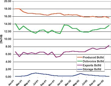
Figure 1 shows Alberta’s total gas production (red),marketed gas (green),exports to the US (purple),and gas injected into storage (blue) in bcf per day averaged on a monthly basis for the past two years (Source data: AEUB ST-3 Monthly Production Reports).
Because Alberta provides nearly 80% of the total Canadian natural gas production,trends in Alberta can be assumed to reflect Canadian production.As seen in Figure 1, total production has declined from about 18 bcf/d to 16 bcf/d over the past two years while marketed gas has remained relatively constant – how is this possible?
Total production includes shrinkage and other factors.However,it also includes gas produced and stored for sale at a later date. During the summer months when supply exceeds demand the excess is injected into storage reservoirs.This gas is later withdrawn to meet high demand during the winter.In June 2001 we were storing over 1bcf/d for future production but during the summer of 2002 we stored 30% less gas.Consequently the stored gas available for this past winter season was much less than that for the prior year.This left little cushion to meet peak demand and consequently prices skyrocketed.
Additionally,gas exports to the United States climbed substantially during 2002 – these levels cannot be maintained without a considerable increase in production.What are the implications if the U.S.economy strengthens and their demand for natural gas increases?
Are we capable of reversing this trend and increasing the gas in storage during the summer of 2003 or will we see an even more serious problem next winter?
To be continued...
BIOGRAPHY
Dave Russum has spent more than 25 years exploring for hydrocarbons.He recently completed an exhaustive study of Canada’s future gas supply and demand.He has developed some unique approaches to both shorten the timeframe and improve the results of exploration activities.More information can be found at www.geohelp.ab.ca.
INFORMATION
This is part of a series of snapshots of the Canadian industry designed to provide up-to-date information and give possible insights into the future of oil and gas exploration.Comments are strictly the views of the author;however,your feedback is encouraged (dave@geohelp.ab.ca).
BY DAVE RUSSUM
Figure 1: Why Canadian gas prices rose last winter.
geophysical integrity
Land Acquisition
Marine Acquisition
Seismic Processing
Depth Imaging
Reservoir Technologies
Geomatics
Leading edge technology, dedicated people and a passion for delivering results. www.
EARTH SCIENCE EDUCATION: A UNIQUE APPROACH INSIDE AND OUTSIDE THE CLASSROOM
BY DAN CLARK, THE YOHO-BURGESS SHALE FOUNDATION
“…It seems earth science is the forgotten science in our classrooms.However,the need for professional geoscientists in our society has not diminished,and is now greater than ever with concerns over environmental issues such as clean air,clean water and climate change.There is a need for increased science literacy by the general population,so that the importance of science can be fully appreciated…”
- L.Holmstrom
Until I stumbled upon a Geology course during university,I knew nothing of the earth sciences.I had spent years hiking in the Canadian Rockies without learning about the geology at my feet.At the U of C,Rocks for Jocks 201 opened my eyes to the earth we walk on and irreversibly changed my academic career.I just wish that I had known something of these sciences before I got to university!
When I look back at my education in grade school,I was never introduced to the geosciences.As an honor-role student aiming for matriculation,I took advanced biology,
chemistry,and physics without ever hearing about topics such as plate tectonics or geologic time.Upon reflection,it seems that the geosciences were the forgotten disciplines in my grade school classroom. They still are today…
Increasing the profile of earth sciences inside and outside of our schools is of critical importance to society,because an understanding of our Earth is fundamental to intelligent debate on resource management,natural hazards,and environmental issues,which affect us all.The students of today will become the managers of tomorrow who will be dealing with issues rooted in the geosciences.
Unfortunately,the high school curriculum bypasses the earth sciences.Earth science content makes up a minor proportion of junior and intermediate school science curricula and is often absent in the high school curricula for pure science courses. British Columbia has more extensive earth
science content in its curricula than many provinces,offering Earth Science 11 and Geology 12 courses.Regrettably,these programs are often undersubscribed.For many students and teachers it seems that the earth sciences carry the stigma of the ancient,the unknown,and the impossible.As a result,many of the top students who are pursuing post-secondary education in science-related careers have little exposure to the geosciences.
Attempting to change provincial curricula to explicitly include more earth science is a difficult and time-consuming process that has resulted in many “fossilized” concepts.In order to reach science students,it is necessary to find a way to incorporate earth science into the existing pure science curricula.The YohoBurgess Shale Foundation (TYBSF) and a team of dedicated professional geologists have developed the unique “Applied Continuum Theory,” to introduce earth science into the pure science curricula.This cross-curricular approach illustrates scientific principles taught
ROCK SHOP
in biology,chemistry,and physics with realworld examples from earth science.The benefit of this approach is that it does not require a change to the curricula! The pure sciences cannot help but be enriched by the inclusion of earth science examples and activities because the theory becomes more relevant to students as it is related to their surroundings.TYBSF offers training to high school science teachers through the “Making Connections:Science in the Mountains” earth science enrichment workshop offered August 22-24,2003.This course is designed to increase the teacher’s knowledge of geology while providing them with the tools to enhance their existing curricula with more earth science examples.
Outside of the curriculum are numerous educational opportunities on guided hikes and walks.TYBSF provides a variety of earth science educational programs during the summer holidays from July 1 to September 15.These include guided hikes to the Burgess Shale (Walcott Quarry) and Mt. Stephen fossil beds.There is no better way to gain a sense of the scale of the earth sciences than on a high mountain hike where you are surrounded by impressive peaks! Geology is a massive topic and the best classroom is one without walls.These
programs are available to students and teachers as well as the general public.
In celebration of the UNESCO International Year of Fresh Water,TYBSF is conducting two feature programs that investigate themes linked to water.These programs are made more widely accessible to the public through generous assistance from the Suncor Energy Foundation.The first is a “Guided Hike on Climate Change” on the Iceline Trail in Yoho National Park.On this spectacular trip,participants hike close enough to touch a glacier while learning about climate of the past,present,and possibly the future.The second program is designed especially to educate and excite kids 6-12 about the earth sciences.In “The Mysterious Death of Ancient Ocean Monsters” children will actively participate in a search for clues to solve the mysteries of the extinction of trilobites.Modern day arthropods and Cambrian fossils provide the clues.These non-curricular activities inspire an appreciation of geosciences that will translate to increase science literacy for the children and adults who participate.
Changes in earth science education sprout from the timely and essential transfer of new knowledge and paradigms among the
research community,teachers,and students. This revolution will promote inquiry-based investigations and new strategies in classrooms.At a deeper,more important level,the changes TYBSF are promoting in earth science education are essential to our future.A citizenry literate in the earth sciences is essential to inform political and economic decisions that effect people on local,regional and global levels.
ACKNOWLEDGEMENTS
Lisa Holmstrom and a team of volunteers have been instrumental in developing the “Applied Continuum Theory.”The volunteers are Philip Benham (Shell),Clinton Tippett (Shell),Jon Dudley (CNRL),Charles Henderson (U of C),Darren Edwards (Shell),and Stan Stancliffe (Esso).
Sponsorship of the Teacher Training Workshop has been provided by the EdGeo program of the Canadian Geoscience Education Network, Suncor Energy Foundation,Canadian Geological Foundation,and CSPG Educational Trust Fund.
ADDITIONAL INFORMATION IS AVAILABLE AT: Website:www.burgess-shale.bc.ca Phone:1-800-343-3006
E-mail:burgshal@rockies.net
2003 CALENDAR OF EVENTS
DATE: June 2-6,2003
EVENT: 2003 CSPG/CSEG Annual Convention - “Partners in a New Environment”
LOCATION: Round Up Centre,Stampede Park,Calgary,Alberta
INFORMATION: For more information please contact Lori HumphreyClementsTel: 403-264-5610 Email:lori@cspg.org
DATE: June 23,2003
EVENT: CSEG Technical Luncheon
LOCATION: Telus Convention Centre – 11:30 am
INFORMATION: CSEG Speaker: Robert Vestrum (Veritas) Title: Smearing the Sideslip and Other Anisotropy Problems - Or " Don't hate me because I am beautiful:3D anisotropic depth migration in the Canadian Foothills". Ticket Orders: Contact Lisa Eastman,CSEG Volunteer Ticket Coordinator. Deadline: Wed before Monday Lunch,Price$25+GST ($26.75) See CSEG website - under Upcoming Luncheon for ticket order form
DATE: August 10-14,2003
EVENT: GeoSciEd IV:Earth Science for the Global Community
LOCATION: Calgary,Alberta
INFORMATION: The fourth international meeting for earth science teachers from elementary to university level,and for earth scientists who deliver educational outreach programs through their communities,museums,or science centres.The purpose is to share ideas and concepts in earth science education and in the development of programs that lead to an integrated
understanding of the Earth.The innovative technical program will include keynote addresses,workshops, and oral and poster sessions.Field trips will visit many world-renowned sites of interest including the Rocky Mountains,the Burgess Shale,the Royal Tyrrell Museum of Paleontology,the Frank Slide,and the Athabasca Glacier. Please visit www.geoscied.org for details.
DATE: September 21-24,2003
EVENT: The Society for Organic Petrology (TSOP), 20th Annual Meeting
Abstracts due 4/15/03.Oral and poster sessions September 22-23.Topics include petroleum systems, source rocks,coalbed methane,coal characterization (Ron Stanton memorial session),government,and energy.Short courses (Sept.21) on trace elements in coal and health impacts of coal plus a core workshop on coal and petroleum source rocks of the National Petroleum Reserve in Alaska.Field trip (Sept.24) on geology and energy resources of the Triassic basins of northern Virginia.
Please visit www.cspg.org to download or print the monthly version of the calendar of events.
CANADIAN SOCIETY OF PETROLEUM GEOLOGISTS CALL FOR NOMINATIONS
2004 EXECUTIVE COMMITTEE
In accordance with Article VI,subparagraph (a) of the By-Laws,the Nominating Committee hereby calls for Nominations to Stand for Election to the 2004 Executive Committee of the Canadian Society of Petroleum Geologists.Nominations are to be made in writing,signed by at least twenty-five members in good standing and endorsed by the nominee who is consenting to stand for office.Nominations should be forwarded to the CSPG office by September 15,2003.The slate of candidates will be published in the November Reservoir and the election will take place on November 30,2003.The following vacancies exist for 2004:
Vice President
Assistant Finance Director
Assistant Program Director
Assistant Services Director
Successful candidates for the Directorships will serve two-year terms and the elected Vice President,a three-year term.Interested parties should contact the office for details and general requirements of service on the Executive.
CSPG VOLUNTEER COORDINATOR
If you are looking for a volunteer opportunity within the CSPG,Blythe will be happy to help you find your volunteer niche.
She can also provide information about any of the Society’s numerous committees if you require it.
Blythe will also assist with finding replacements for current committee volunteers who need a change and help them to find different volunteer opportunities in the Society,if desired.
Blythe Lowe can be reached in Calgary at 403-290-3516. Give her a call!
Superior Wellbore Data for Western Canada and the Frontier Areas
Always Available... Always Accessible
INTERNATIONAL PETRODATA LIMITED
Make Your Decisions With a Higher Degree of CONFIDENCE Make Your Decisions With a Higher Degree of CONFIDENCE
... through the following comprehensive map based software solutions:
... through the following comprehensive map based software solutions:
Open System Solutions
Open System Solutions
QByte Services Ltd.
QByte Services Ltd.
■ Petro-LAB™ Decision Technology Corp.
■ Petro-LAB™ Decision Technology Corp.
■ Quick Select Schlumberger Information Solutions
■ Quick Select Schlumberger Information Solutions
■ PetroDesk™ international Datashare corporation
■ PetroDesk™ international Datashare corporation
■ GEOcarta™ (Capture)
■ GEOcarta™ (Capture)
Packaged System Solutions
Packaged System Solutions
IHS AccuMap
IHS AccuMap
■ AccuMap™
■ AccuMap™
■ Accu-X™ geoLOGIC systems ltd.
■ Accu-X™ geoLOGIC systems ltd.
■ geoSCOUT™
■ geoSCOUT™
Web Browser Solutions
Web Browser Solutions
Geo Webworks Inc.
Geo Webworks Inc.
■ Geo Webworks Petroleum Place
■ Geo Webworks Petroleum Place
■ DataMap™ Product Line Veritas GeoServices
■ DataMap™ Product Line Veritas GeoServices
■ GOLD
■ GOLD
THE PETRODATA FILE
THE PETRODATA FILE
Since 1963, the industry's only database that is created from original source documents; the result is the most accurate, complete and consistent database available today.
Since 1963, the industry's only database that is created from original source documents; the result is the most accurate, complete and consistent database available today.
■ General Well Data
■ General Well Data
■ Formation Tops (correlated by IPL)
■ Formation Tops (correlated by IPL)
■ Fluid Analyses (oil, gas, water)
■ Fluid Analyses (oil, gas, water)
■ Core Analyses
■ Core Analyses
■ Directional Surveys
■ Directional Surveys
■ Production/Injection
■ Production/Injection
■ Gas Well AOFP
■ Gas Well AOFP
■ Oil Well BHP
■ Oil Well BHP
■ Reserves
■ Reserves
TIME - Your Most Valuable Resource
TIME - Your Most Valuable Resource
Spend Less Time Verifying Data and More Time Interpreting & Analyzing RESULTS!
Spend Less Time Verifying Data and More Time Interpreting & Analyzing RESULTS!
Project Based and Special Application Business Partners
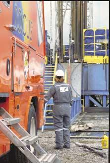
New High-Efficiency Open Hole Logging System to Debut in Western Canada
The latest in high-efficiency premium open hole logging systems – FOCUS from Baker Atlas – will make its debut in the Western Canadian market in the summer of 2003. All of the downhole instruments have been redesigned, incorporating advanced downhole sensor technology, into shorter, lighter, more reliable logging instruments, capable of providing formation evaluation measurements with the same precision and accuracy as the industry’s highest quality sensors, at much higher logging speeds (up to twice the speed of conventional triplecombo and quad-combo logging tool strings). The logging system consists of the four major open hole measurements, plus auxiliary services.
■ Array Resistivity (FOCUS HDIL) –includes real-time 1-D radial inversion processing for more accurate measurements of R xo and R t
■ Nuclear Porosity (FOCUS ZDL & FOCUS CN) – design changes have improved the detector responses and efficiencies thus enabling higher logging speeds than are possible with conventional instruments. A nuclear porosity cross-plot log is also delivered in real-time .
■ Acoustic Slowness (FOCUS DAL) –offers an improved monopole signal resulting in accurate compressional slowness values (∆t) using a depth derived borehole compensation technique.
■ Auxiliary MeasurementsCorrelation Gamma Ray (GR), Borehole Temperature, Downhole Tension, Mud Resistivity, Accelerometer (TTRmA), Two Arm Caliper (TAC).
At first glance, one would ask “why does the Canadian formation evaluation market need another triple
combo? Is this just another commodity service in the marketplace?” It is, however, many years since a comprehensive sensor and deployment redesign has taken place of conventional logging instrumentation.
The opportunity to redesign a classic quad combo provided for instrument redesign with an emphasis on today’s issues in development well logging—wellsite efficiency and data accuracy. The introduction of FOCUS, the latest high-efficiency, highaccuracy, short-string quad or triple combo, has proven during field testing in Western Canada that a new benchmark in these attributes is possible. Field tests have demonstrated a consistent improvement in accurate open hole data, centered around instrument reliability and minimized logging time through logging speed and rig up/down efficiency.
Real-time quality control and analysis at the wellsite accelerates the usability of acquired data, translating to a variety of value-adding products to the operator. Improved measurement quality has some significant advantages over current approaches— from fast and reliable formation evaluation for reserve estimation to accurate delineation of reservoir intervals for improved completion efficiency. Adding to that modern use of webenabled data transfer and viewing
FOCUS Instrument Specifications Triple
A comprehensive field test of the new high-efficiency logging system—FOCUS from Baker Atlas—was centered in Western Canada, and included logging over 45 wells.
techniques, log data transmitted from the wellsite directly into Baker Atlas’ Total RECALLTM database system, and from there the data user’s laptop, clients can easily access data when and where they need to. The new FOCUS Logging System is available today in Canada and will soon be available in other regions of the world.
Contact Dave.Shorey@bakeratlas.com (403-537-3663) for more information about the FOCUS Logging System.
JACK PORTER-
CANADIAN PETROLEUM GEOLOGY
The Extraordinary Odyssey of R.
G. McConnell
The following,relating to the North West and Hudson’s Bay Companies exploration in Canada’s far northwest,will hopefully serve to set the stage for the subsequent role played by R.G.McConnell during his 18871888 exploration of the Mackenzie River and Yukon basins.
Arduous and extensive travel,within relatively uninhabited regions of Canada,has been the tradition of those dedicated Geological Survey of Canada’s geologists,past and present,who have chosen to spend successive seasons in the field.This calling was particularly evident following the Hudson’s Bay Company relinquishment of it’s Rupert’s Land territory in late 1869 and the subsequent incorporation,in 1870,of this vast area into the burgeoning Dominion of Canada.It was propitious,at this juncture,that Alfred R.C.Selwyn had replaced
Sir William E.Logan to become the second director of the Survey,a position he held until 1895.As the new director,he undoubtedly proposed that reconnaissance mapping be undertaken in the territory formerly comprising Rupert’s Land (Hudson’s Bay watershed),as well as those lands in northwest Canada lying within the Arctic watershed.It was self-evident that in order to expeditiously map these remote and relatively unexplored tracts of land it was necessary to traverse their navigable rivers.The preponderance of and accessibility to rock outcrops,flanking their shores,would afford a optimum of geological information.The season for field investigation in northern Canada is understandably short, being confined to a period between late spring breakup of ice on the lakes and rivers and their freezing over in early autumn.
These late 19th-century Survey geologists made good use of their interdisciplinary skills. This knowledge enabled them to incorporate
in their geological reports not only economic synopses relating to the occurrences and locations of minerals,including coal and petroleum that they observed,but comments directed to climactic conditions and agricultural capabilities.The identity of native trees and small plants were documented according to their formal taxonomic names and flowering specimens were collected for further classification by botanical specialists in Ottawa.Collections of fossil specimens were of paramount importance in unraveling the age(s) of the stratigraphic sequence encountered,particularly in those hitherto unmapped areas of much of northwest Canada.The tribal affiliation of the various indigenous natives they came in contact with were identified according to their linguistic stock.The names and locations of active or abandoned Hudson’s Bay trading posts, including independent operators,were indicated on the Survey’s late 19th century geologic maps of northwest Canada.Historic
accounts,contained in reports by the Survey’s geologists,of those explorers who had previously visited their respective areas of study,served to chronologically acknowledge their predecessor’s exploits.
Indispensable to the successful operations of the Survey’s geological parties,particularly in unfamiliar regions,were the Métis,natives,and white men,who had honed their skills to survive in the harsh environment.Some were engaged by the geologists as boat and canoe builders,but for the most part,they served them as guides and boatmen in expediting the navigating of lakes and rivers.Many of the Métis had formerly been employed as voyageurs in service of the Hudson’s Bay Company and were well acquainted with the potential hazards of the rivers.Their manual duties involved long stretches of paddling, poling through or “running” the rapids, backpacking supplies and equipment and transporting the wooden boats and canoes across portages.In ascending swift-flowing, rapid-infested rivers,it became necessary for these stalwart servants to engage in the grueling and beast-like task of tracking,a procedure which involved the hauling in tandem their craft upstream.
The onset of the decline of the Hudson’s Bay Company’s commerce in furs had commenced at least a decade before it had relinquished Rupert’s Land to the Dominion of Canada.Accompanying this decline was the abandonment of many of it’s trading posts, resulting in the disengagement or transfer of post employees.More significantly,their closing impacted the livelihood of the voyageurs involved with the annual fur brigades.These consisted of the transport of trade goods in spring to the “upper country” and the return during late summer with furs destined for their eastern depots.Many of these former voyageurs had chosen to reside in northwest Canada with their native partners and children.These venturous individuals,most of whom were of FrenchCanadian descent,as well as their Métis progeny,were the tangible legacy left by the Company.It was only logical that the Geological Survey of Canada’s field parties would benefit from the recruitment of these experienced and knowledgeable river men. The natives of northwest Canada,whose hereditary life-style was inextricably dependent on the systems of lakes and rivers, were also availed upon by the Survey’s geologists to serve as canoe builders, paddlers,guides,packers,and hunters.
The far northwest was to experience a new era of exploration by a group of explorers whose motivation,unlike their predecessors,
was not bent on the quest for new furbearing regions,but was purely scientific in scope.Lawrence J.Burpee (The Search for the Western Sea,pub.Mission,1908,p.57) succinctly enunciates the chronology of the exploration phases by stating:“If the history of exploration in the far west is divided into three periods,the first may be said to be the North West Company,the second the Hudson’s Bay Company,and the third the Geological Survey of Canada.”
Immediately following Alexander Mackenzie’s epic journey in 1789 to the Arctic Sea,along the river named in his honour,its drainage basin became recognized as an accessible,untapped region for the trafficking of furs.Mackenzie was associated with the North West Company during the period of his voyage,having been made a full partner in 1787.The XY Company (New North West Company) came into existence in 1798 and resulted from a dissatisfied faction which had extricated themselves from their former Company.the denotation of the letters “XY” were not abbreviated words but were rather akin to a cattle brand,which was stamped on their bales of fur so as to prevent confusion with those of the North West Company.In late 1804 the two rivals merged,under the North West Company banner,to become a formidable competitor to the Hudson’s Bay Company.
It was during the first decade of the 19th century that the more aggressive North West Company made incursion into the Mackenzie River valley,establishing trading posts along the length of the Mackenzie River.These establishments were usually located at the confluences of some of its major tributaries, namely:the original Fort Liard (later renamed Fort Simpson),Fort Norman,and the original Fort Good Hope.North West Company posts,pre-dating 1812,were situated up major tributaries of the Mackenzie River,notably Fort aux Liards on the lower reaches of the Liard (Liard being a French name for a variety of poplar tree) and Fort Nelson,located on the upper reaches of the Fort Nelson River. The latter river was originally referred to as the “East Branch of the Liard River.”
The relatively unrestricted competitiveness that the North West Company enjoyed in the far northwest was short-lived.The altruistic motives of Lord Selkirk in establishing a colony in 1812 of disposed crofters in the Red River Métis settlement of Rupert’s Land sent reverberations throughout the northwest.He and his family,by accumulating a major portion of Hudson’s Bay Stock, obtained from the Company a vast land grant
which they designated “Assiniboia”.It had comprised an area which now consists of portions of Saskatchewan,Manitoba,Ontario, North Dakota,and Minnesota.Conflict, instigated by the Métis and North West Company,commenced from its inception.An embargo had been placed on the export of pemmican from the colony in 1814,which result had placed the livelihood of the Métis buffalo hunters and their families in jeopardy. The ensuing violence and vandalism culminated in 1816 at Seven Oaks with the massacre,by the Métis,of 21 of the colonists, including Robert Semple,their governor. Although the Nor’Westers were not directly involved in the slaughter,they were nevertheless implicated as accessories.The animosity between the two companies continued to persist,when paradoxically,it was terminated by their union.
In 1820,George Simpson was sent by the Hudson’s Bay London committee headquarters to the Athabasca district during the simmering rancor of the rivaling companies.He had been sent there from London as a potential replacement for the then Governor Williams,should the latter be arrested by the North West Company. Williams’ arrest never came to pass since the feuding parties differences were resolved by their amalgamation in 1821.The expanded Hudson’s Bay Company was now master of its far-flung domain,having effected a monopoly of the fur trade in both the Hudson’s Bay and Arctic drainage systems.
With the merger a fait accompli,Simpson was appointed governor of the Northwest Department and in 1826 was promoted to governor of the Company’s operations in British North America.As governor,he became familiar,through his extensive travels,with not only the geography of the remote terrains he administered,but also the personnel who operated the company’s posts.His insatiable curiosity concerning his chief factors,chief traders,clerks, postmasters,and servants were recorded in his ‘Character Book’ which was a personal assessment of each employee expressed in a detached manner and unequivocal candor. (Hudson’s Bay Miscellany 1670 - 1870,The Hudson’s Bay Record Society,1975,vol. XXX.pp.167 - 236) His God-like judgement appears to have been seasoned by his egotism.George Simpson was knighted in 1841 for his organizational skills,business acumen,and exploration achievements.He also received,during his tenure,a second dubbing by his compatriots with the sobriquet:“The Little Emperor”.
2003 CSPG / CSEG CONVENTION
PARTNERS in a newENVIRONMENT
Organizing Committee:
General Co-Chair (CSPG)
Wayne Foo Hardisty Resources Ltd.
General Co-Chair (CSEG)
Jim Stenhouse Intercontinental Seismic Surveys Ltd.
Ideal for those who wish to improve their geological understanding of where and how we look for oil and gas fields in Western Canada.
•Visualize what Western Canada looked like throughout history, for example, the position of the sea versus land, what sediments were deposited, and what type of life that existed and evolved.
•Review the importance of each major stratigraphic unit, ie. Devonian, Mississippian, Cretaceous, etc.
•Discuss the geological and seismic expression of typical oil and gas fields in each unit.
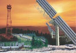
CALGARY TO BANFF FIELD TRIP
Date: June 20, 2003 Cost: $160.50 incl. GST
Instructor: Bill Ayrton
Useful for anyone working in the oil and gas industry, and interested in the geological features so beautifully displayed in our mountains. Individuals wanting to understand the geology underlying the Plains, the Foothills, and the Rockies and their fundamental relationship to our search for oil and gas, will find this field trip worthwhile. We will:
•Review the oil and gas potential of each of these areas.
•Make a number of stops at classic locations including a short hike to the Grassi Lakes reef section.
•Illustrate how the magnificent exposures seen in the Rockies can help with the subsurface interpretation of the Western Canadian Sedimentary Basin.
•Appreciate the tectonic forces of mountain building.
WHO SHOULD ATTEND
New geologists, engineers, geophysicists and landmen, as well as summer students entering the industry for the first time will find the courses a very beneficial introduction to the petroleum industry. These courses will be extremely useful to nonprofessional and support staff in the oil and gas industry, as well as accountants, lawyers, brokerage and financial personnel working primarily alongside the oil and gas industry.
TO REGISTER
To request a brochure, to register, or to obtain additional information regarding in-house and upcoming courses contact:
Ayrton Exploration Consulting Ltd.
Tel: (403) 262-5440
Email: ayrtonex@telusplanet.net
Or visit our website: www.ayrtonexploration.com
NET PAY IN NATURALLY FRACTURED RESERVOIRS
BY ROBERTO AGUILERA, PH.D., P.ENG., SERVIPETROL LTD., CALGARY, CANADA
The recent article “Net-To-Gross Ratios” by Etris and Stewart (Etris,N.and Stewart,B. 2003) raised some valid points to clarify concepts of net pay,net thickness,and net-togross ratios.Their example 2 shows that net pay is characterized by (relatively) high porosity,high permeability,and high hydrocarbon saturation.User-defined cutoffs of these characteristics determine the amount of net pay.My note has to do with naturally fractured reservoirs (NFR) where intervals with low porosity and low permeability,which do not meet conventional cutoff criteria,can constitute net pay.
It has been found through selective perforating, production logs,and rock mechanics experiments in cores,that for the same physical environment and stresses – other things being equal – the amount of natural fracturing increases as porosity and permeability of the host rock decreases.This in turn leads to the recommendation,that unless there is supporting information to the contrary,it is better not to use porosity and permeability as cutoff criteria in NFR.The message is not that we should forget about intervals with high porosities and permeabilities,but rather that we should never overlook low permeability and low porosity intervals in NFR.
Darcy’s law indicates that fluid rate is equal to permeability times area times pressure differential divided by fluid viscosity and distance.The reservoir area exposed to the wellbore is typically very small.For low permeability reservoirs,that small area does not allow significant hydrocarbon flow into the wellbore.However,if there is natural fracturing around the wellbore that extends throughout a large portion of the reservoir, the matrix area exposed via the fractures can become quite significant.In this case the product of the large area times the small permeability can allow very efficient hydrocarbon flow from matrix to fractures and then to the wellbore,constituting what is usually known as a dual-porosity reservoir.
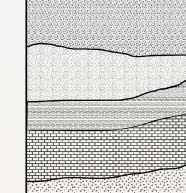
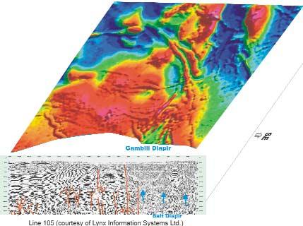
In a “conventional” unfractured reservoir,the rock must be capable of allowing direct hydrocarbon flow into the wellbore to constitute net pay.In a NFR,the rock,usually called matrix by reservoir engineers,does not have to necessarily permit direct hydrocarbon flow into the wellbore to constitute net pay. Figure 1 shows a schematic of a multi-layered
NFR (Aguilera,R.and Aguilera,M.S.2001).The production log shows that there are only two zones where fluids enter the wellbore. However,the whole section from top to bottom is net pay.
If porosity and permeability are not advisable in many cases as cutoff criteria,how can we estimate net pay in a NFR from wellbore data? In my experience,water saturation, shaliness,and pore throat aperture,as well as keeping an eye on well-testing data,provide reasonable criteria.
I have many times used water saturation cutoffs in the order of 55%,although there are exceptions.When calculating S w (e.g.,Swn = (aRw)/(φmRt)) keep in mind that the dual porosity exponent m of the fractured intervals is smaller than the porosity exponent mb of only the matrix as determined from unfractured plugs.Be also careful with the scaling of matrix porosity to avoid potential errors in the calculation of S w.(Aguilera,R.and Aguilera,M.S.2003).The larger the amount of natural fracturing,the smaller the value of m will be.A useful assumption is that the required water saturation exponent n is approximately equal to m
Shaliness is also a very important cutoff criterion.As plasticity increases there is less probability of finding fractures.Therefore Vshale is very valuable for determining net pay in NFR. The variability of Vshale as a cutoff can be quite significant from reservoir to reservoir.For example,there are reservoirs where fractured shales produce at commercial oil and gas rates.
Pore throat apertures of the matrix can be estimated from mercury injection capillary pressures.If not available,there are empirical correlations that can help in the determination of the pore throat apertures.Particularly useful are the Winland r35 pore throat aperture as explained by Martin et al (Martin,A.J.,Solomon, S.T.,and Hartmann,D.J.1997).The derived rp35 radii can than be superimposed directly on Pickett plots (Aguilera,R.2002a,2002b).Martin et al provide potential oil rates that can be obtained from different pore throat sizes.
Well-testing data can help to determine,via the “valley” generated by the pressure derivative,if the tight matrix is contributing production to the fractures (not to the wellbore).Also,a derivative with a negative
Figure 1: Schematic of multi-layered,naturally fractured reservoir.Production log at left shows two zones where hydrocarbons enter the wellbore. However,the whole interval from top to bottom is net pay in this case.
slope of 0.5 might indicate that fractures not intersected by the wellbore could be contributing to production.
Determining whether zones of low porosity and / or low permeability contribute net pay is not an easy problem.But by keeping in mind the guidelines presented above,a more realistic estimate of net pay should be obtainable for naturally fractured reservoirs.
REFERENCES
Aguilera,R.2002a.Incorporating Capillary Pressure,Pore Throat Aperture Radii,Height Above Free Water Table,and Winland r35 Values on Pickett Plots.AAPG Bulletin,v.86/4,p.605-624.
_________.2002b.Determination of Matrix Flow Units in Naturally Fractured Reservoirs. Paper 2002-157,presented at the Petroleum Society Canadian International Petroleum Conference.Calgary,Canada,June 11-13,2002.
Aguilera,R.and Aguilera,M.S.2001.Well Test Analysis of Multi-Layered Naturally Fractured Reservoirs with Variable Thickness and Variable Fracture Spacing.Journal of Canadian Petroleum Technology,v.40/12,p.9-12.
________________________.2003.Improved Models for Petrophysical Analysis of Dual Porosity Reservoirs.Petrophysics,v.34/1,p.21-35.
Martin,A.J.,Solomon,S.T.,and Hartmann,D.J. 1997.Characterization of Petrophysical Flow Units in Carbonate Reservoirs,AAPG Bulletin,v. 81/5,p.734-759.
BIOGRAPHY
Dr.Roberto Aguilera is president of Servipetrol Ltd. and an Adjunct Professor in the Chemical and Petroleum Engineering Department at the University of Calgary,where he concentrates in teaching about the theoretical and practical aspects of naturally fractured reservoirs.He is a petroleum engineering graduate from the Universidad de America at Bogota,Colombia and holds M.Sc.and Ph.D.degrees in Petroleum
Engineering from the Colorado School of Mines. He has presented his course on Naturally Fractured Reservoirs and has rendered consulting services throughout the world.He is a Distinguished Author of the Journal of Canadian Petroleum Technology,a recipient of the Outstanding Service award from the Petroleum Society of CIM and a SPE Distinguished Lecturer on the subject of Naturally Fractured Reservoirs.
KEEPING TRACK
New:
Senior Development Geologist
ChevronTexaco Overseas Petroleum
Partitioned Neutral Zone (PNZ), Kuwait
Pr evious: Block 14 BBLT - Development Coordinator
ChevronTexaco Overseas Petroleum Luanda, Angola
TAKO KONING
New:
Angola Residential Representative, Yme Foundation (NGO involved with water well drilling & community assistance in Angola)
Pr evious: Kwanza Basin Exploration Manager ChevronTexaco, Luanda, Angola (retired after 29 years worldwide with ChevronTexaco)
EXPLORATION AND TECHNOLOGY UPDATE
PRELIMINARY TECTONIC MAP
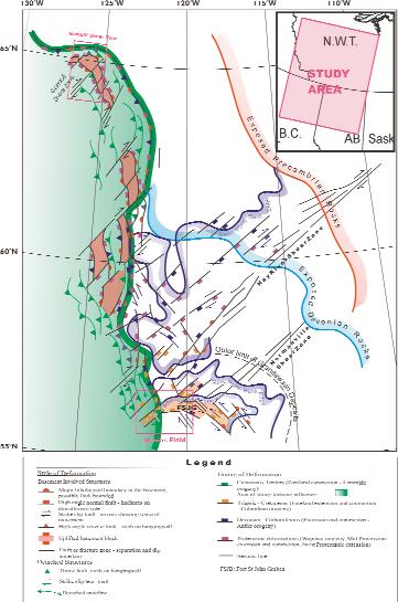
OF THE WESTERN CANADA SEDIMENTARY BASIN
BY ZEEV BERGER AND XIANG WANG, IMAGE INTERPRETATION TECHNOLOGIES INC. (IITECH)
INTRODUCTION
For many years,most exploration geologists have regarded the Western Canada Sedimentary Basin (WCSB) as a “stratigraphic basin”,and consequently a great deal of research has been done to establish the
stratigraphic framework of this basin.However, little attention has been directed to the mapping and analysis of the main tectonic elements present in the WCSB,nor to their style of deformation and potential influence on hydrocarbons plays.The benefits of this latter
approach have been well demonstrated in regional tectonic studies (Barclay et al.,1990; Ross,1990;Ross et al.,1994),and through a recent geological study by Davies (1996),which illustrates the strong link between deep-seated faults and the development of hydrothermal dolomite (HTD) reservoirs in the Devonian and Mississippian sections of the basin.
During the past several years,IITech has had the opportunity to conduct a number of regional geologic studies in the WCSB.These studies relied primarily on the analysis of highresolution aeromagnetic (HRAM) data,and regional seismic lines that were assembled from both published and unpublished sources. The knowledge and expertise gained through this work allowed IITech to begin assembling a new tectonic map of the WCSB.In this paper, we wish to illustrate some of the major findings from this effort.It is important to mention that the maps shown here have been generalized and represent work in progress. There are two objectives to this paper:first,to illustrate the styles of deformation of various geological structures present in the basin,and second,to demonstrate the benefits of integrating regional seismic and HRAM data during basin analysis.We also plan to publish a follow-up paper illustrating the control of some of these structures on various hydrocarbon plays in the WCSB.
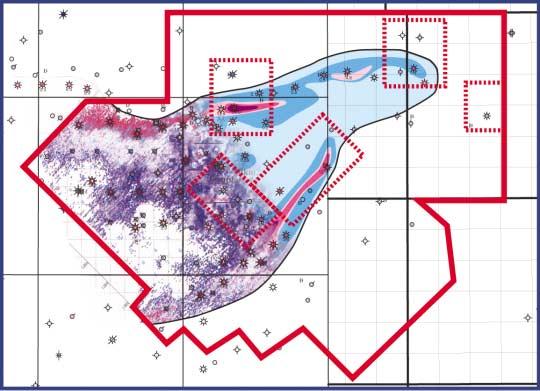
GENERALIZED TECTONIC MAP
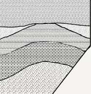
A generalized tectonic map illustrating the key faults and fracture systems identified in the northern portion of the WCSB is shown in Figure 1.This map was compiled from published data as well as from our interpretation of HRAM and regional seismic data.Two major aspects related to the faulting are illustrated in this figure:(1) style of deformation;and (2) time of motion.From a structural-style point of view,the structural elements have been divided into two categories:(1) basement-involved structures; and (2) detached structures (mostly related to shallow thrusting).Basement structures may be further subdivided into those that follow basement lithological boundaries and those that intersect these boundaries.
The tectonic map in Figure 1 attempts to highlight motion of individual faults,as well as outline the extent of the area affected by particular tectonic episodes.For example,the area affected by the Cretaceous-Tertiary Laramide Orogeny is highlighted in green on the map.Four major tectonic events are
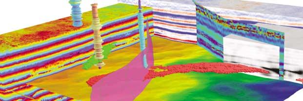
Figure 1.Generalized tectonic map of the northern part of the West Canada Sedimentary Basin. Two excellent examples of reactivation along NE-trending faults are highlighted in this figure (pink boxes):the Monias Field and the Gambill Shear Zone (GSZ).
Continued from Page 30 ...
recognized:(1) Proterozoic deformation,which includes the Wopmay Orogeny,Middle Proterozoic extension and subsequent contraction,as well as rifting in the Late Proterozoic;(2) Devonian-Carboniferous deformation,such as the Antler Orogeny,which includes the collapse of the Peace River Arch; (3) Triassic-Cretaceous foreland extension and contraction of the Columbian Orogeny;and (4) Cretaceous-Tertiary foreland contraction of the Laramide Orogeny.
A more detailed version of this map includes a third element which consists of oil and gas pools that are clearly controlled by faulting. These pools are divided into three categories: structural traps,stratigraphic traps,and combination traps.
ANALYSIS OF KEY STRUCTURAL ELEMENTS WITH SEISMIC AND HRAM DATA
Figure 2 illustrates how available magnetic and regional seismic data can be used to assess the style,intensity,and timing of deformation of key structures in the basin.The GSC regional magnetic data (2a) highlights the magnetic signature of the major basement features observed in northeast British Columbia.The HRAM and regional seismic data further enable us to divide the whole
area into two zones (separated by the green line):(1) the eastern area,which was not significantly affected by the Laramide Orogeny;and (2) the western area,which was strongly affected by Laramide Orogeny.
The portion of the WCSB east of the deformation front is characterized by basement structures that can often be recognized in the magnetic data.However, faults associated with these structures do not form strong and coherent expressions on seismic data.In addition,these faults generally die out in the Mesozoic section and rarely show evidence of Laramide movement.In situations like these,HRAM data become very useful for detecting basement faults.For example,the complex fault pattern of the Hay River Shear Zone (HRSZ) can easily be recognized in the HRAM data of Figure 2b.The imagery reveals that the main fault zone is crosscut and offset by several northwesttrending features that may form a series of tilted fault blocks with small “pull-apart basins”.A seismic line across the HRSZ (Figure 2c) reveals that the extension of the Proterozoic flower structure is characterized by extensional structures in the Paleozoic and lower Mesozoic strata.Figure 2d illustrates the possible kinematic relationship between
movement along the NE-trending HRSZ and regional compressional principal stress during the Laramide deformation.The seismic interpretation shown in Figure 2e shows that the HRSZ is characterized by a positive flower structure in Precambrian strata and hybrid flower structures structure within the Paleozoic and lower Mesozoic strata,which implies reactivations of the HRSZ,possibly during the Antler and Laramide orogenies respectively.This variation in structural styles within the HRSZ possibly resulted from multiple reactivation events with different sense of movement during Phanerozoic time.
The basement in the area west of the deformation front is relatively deeper.Major basement structures within this portion of the basin are characterized by folded and / or normal fault-bounded basement highs. Normal faults cutting across Precambrian and Paleozoic strata may have resulted from thrust loading during Laramide time.The HRAM data in Figure 2f shows that low- and high-frequency magnetic anomalies can be used to detect basement and near surface structures respectively.The major structural style shown in Figure 2g is characterized by folds and thin-skin thrusts influenced by basement structures.The presence of
Figure 2.Structural Styles in northeast British Columbia. (a) GSC regional aeromagnetics;(b) Residual HRAM (Fugro and IITech proprietary data) for the inset outlined in (a);(c) Structural deformation styles along seismic lines across the Hay River Shear Zone;(d) Strain ellipse showing the possible kinematic relationship between movement along the NE-trending HRSZ and regional compressional principal stress during Laramide deformation,(e) Structural deformation styles along seismic lines across the Hay River Shear Zone;(f) residual HRAM (Fugro and IITech proprietary data) for the inset
in (a);(g) & (h) Structural deformation styles along seismic lines across basin boundary. Continued on Page 34 ...
A Message to our Customers
As we enter our third decade of providing service to our customers, we wanted to find out how well we are meeting your needs.
We hired an independent market research firm to ask you, and the results were:
81% said they would recommend us to others;
95% said they would renew their contracts.
Only 6% said that their satisfaction with us had decreased.
Thank you for placing your trust in us. To the 6% of you that we disappointed, we’d like to apologize and promise to try harder next year.
- Thank you from all of us at geoLOGIC
basement highs/ramps appears to have strongly influenced the development of the overlying thrust and fold belt.Many of the folds are basement-cored,which indicates basement involvement during the Laramide Orogeny.Laramide contractional structures mainly developed above and to the west of major basement ramp/high.The overall basement configuration resulted in an eastward decrease in sedimentary cover deformation during Laramide deformation. Some extensional basement structures may have been reactivated during Phanerozoic time,possibly providing conduits for upward migration of the HTD fluids.A similar structural deformation style is also shown
along the seismic interpretation in Figure 2h. Here,thrusts and associated detached folds typically developed above basement structures,indicating involvement and strong influence of the basement on the development of the overlying thrust and fold belt during the Laramide Orogeny.
Another unique type of structural reactivation present in the WCSB occurs along northeast-trending basement faults that form the dominant fabric of the Precambrian basement.From a kinematic point of view, these faults appear to have undergone strikeslip reactivation as a result of northeasterly regional compressional stress during the
Laramide Orogeny.Two excellent examples of this process are highlighted in Figure 1 (pink boxes):the Monias field and the Gambill Shear Zone (GSZ).
The Monias Field developed along the reactivated southern arm of the Fort St.John Graben.Figure 3 illustrates that fault reactivation led to a partial inversion of the graben (Figure 3a) and the formation of an impressive structural trap within the Halfway reservoir.The thickness of the Triassic Halfway sediments increases across the graben boundary fault,indicating extensional structural control during the graben phase (Figure 3b). During the Laramide Orogeny,transpressional reactivation of pre-existing normal faults resulted in partial inversion of the graben.
The Gambill Shear Zone (GSZ) is found in the Norman Wells area (Figure 4).Figure 4a illustrates that the Gambill Diapir acted as a transfer zone linking the GSZ and the Norman Range Thrust (MacLean and Cook,1999). Geological mapping (Figure 4b) shows that the major tectonic elements in this area are only partially exposed at the surface.However, through the HRAM data (Figure 4c-d) we can recognize that the transfer zone reflects the presence of a complex shear element that exhibits basement-involved right-lateral faulting,which resulted in a complex pattern of surface and near-surface anticlines.The block diagram in Figure 5 illustrates that the GSZ consists of high-angle wrench faults and a series of tight,salt-cored anticlines that developed and wrapped around a basement high to the north.Strike-slip reactivation of northeast-trending basement faults may have triggered the development of salt diapir structures along this fault zone during the Laramide deformation.
CLOSING COMMENTS
A systematic analysis of major tectonic elements can provide significant clues for the recognition of key play elements in the WCSB. This approach is particularly critical as the basin becomes more mature and exploration companies become eager to find new ideas and areas for exploration The assemblage of a tectonic map requires a multi-disciplinary team that can use a variety of data sets,including:1) structural and isopach maps on key horizons; 2) regional seismic lines;3) high resolution gravity and magnetic data sets;and 4) surface geological information.The assemblage of a summary tectonic map that describes all of these elements could be used as a generalized reference point.However,such effort must be complimented with a detailed analysis of key oil and gas pools and prospect areas.
Figure 3.Inversion structures in the Fort St.John Graben. (a) Present-day scenario characterized by partial inversion;and (b) Graben Phase (flattened on top of the Halfway Fm.).
Continued from Page 34 ...
ACKNOWLDEGEMENTS
We would like to thank Norman Kohlhammer who championed our efforts to access regional seismic data in the WCSB.Additional seismic data in critical areas were provided by Ron Miksha and by Lynx Information Systems Ltd.We would also like to acknowledge the IITech technical team, who provided help with data processing and the content of this paper.Finally,we would like to express our gratitude to the many clients who offered their ideas during the interpretation stages of this effort.
REFERENCES
Barclay,J.E.,Krause,F.F.,Campbell,R.I.,and Utting,J.,1990.Dynamic casting and growth faulting:Dawson Creek Graben Complex, Carboniferous-Permian Peace River Embayment,Western Canada.In:S.C. O’Connell and J.S.Bell (eds.),Geology of Peace River Arch,Bulletin of Canadian Petroleum Geology,v.38a,p.115-145.
MacLean,B.C.,and Cook,D.G.,1999.Salt tectonism in the Fort Norman area,Northwest Territories.Bulletin of Canadian Petroleum Geology,Vol.47,No.2,p.104-135.
Ross,G.M.,1990.Deep crust and basement structure of the Peace River Arch region: constraints on mechanisms of formation.In: S.C.O’Connell and J.S.Bell (eds.),Geology of Peace River Arch,Bulletin of Canadian Petroleum Geology,v.38a,p.25-35.
Ross,G.M.,Parish,R.R.,Villeneuve,M.E.,and Bowring,S.A.,1989.Tectonic subdivisions and U-Pb geochronology of the crystalline basement of the Alberta basin,western Canada.Open File 2103.
Ross,G.M.,Broome,J.,and.Miles,W.,1994, Potential fields and basement structure Western Canadian Sedimentary Basin.In:G.D.Mossop and I.Shetsen (comps.),Geological Atlas of the Western Canadian Sedimentary Basin,Calgary, Canadian Society of Petroleum Geologists and Alberta Research Council,p.41-48.
Wheeler,J.O.,and McFeely,P.,(comp.),1991, Tectonic Assemblage map of the Canadian Cordillera and adjacent parts of the United States of America,Geological Survey of Canada,Map 1712A,scale 1:2000000.
BIOGRAPHY
Zeev Berger is the president of Image Interpretation Technologies Inc (IITech).He received a Ph.D.in Geomorphology from
Continued on Page 38 ...
Figure 4.Interpretation of the Gambill Shear Zone on the Norman Wells area. (a) Simplified tectonic map of the Norman Wells area (from MacLean and Cook,1999);(b) surface geological map (Wheeler and McFeely, 1991),(c) GSC HRAM imagery;(d) GSC HRAM imagery with major tectonic elements.
Continued from Page 36 ...
Pittsburgh University in 1977;and earned a Post Doctorate Fellowship in remote sensing at the University of Georgia in 1978.Zeev joined Exxon Production Research Company in 1980 and was leader of their remote sensing group.He left Exxon in 1994 to form IITech as well as presiding over PAZ Energy from 1994-1999.Zeev has published extensively on the subject of integrated remote sensing studies for hydrocarbon exploration,including a textbook entitled “Satellite Hydrocarbon Exploration”.
Xiang Wang is a senior structural geologist at IITech.He received a B.Sc.in Geology from Xi'an Mining Institute (P.R.China) in 1982,a M.Sc.in Structural Geology and Geochemistry from Xi'an Geological College (P.R.China) in 1986,a M.Sc.in Structural Geology and Rock Mechanics from Imperial College (UK) in 1992,and a Ph.D.in Geology from the University of New South Wales (Australia) in 1999.Since graduating,Xiang has worked as a senior structural geologist at IITech, pursuing integrated tectonic studies on the WCSB and some hydrocarbon-bearing basins in the USA.
Figure 5.Block diagram showing GSC residual HRAM and seismic line 105 (courtesy of Lynx Information Systems Ltd.) with interpretation of major structures. Red lines represent faults,while blue arrows indicate salt diapir structures and salt-cored anticlines.
Providing solutions for fully integrated seismic attribute analysis, interpretation, visualization and geological modeling.
TM
• Seismic Interpretation beyond Horizon Picking.
• 3D seismic attribute analysis and interpretation for reservoir characterization.
• Enable users to extract valuable structural and stratigraphic information from seismic data before or after horizon picking.
• Integrated environment for visualizing multiple attribute volumes, horizons, well logs and reservoir grids.
• Seismic facies classification using neural networks and waveform correlation.
• Geobody detection.
• Bridging the scale gap between geology, geophysics & reservoir engineering.
• A revolutionary reservoir geological reservoir-modeling tool.
• Major objective is to solve “cross-scale” problems between cores, well-log, seismic images and well test data.