■ CSPG’S FINAL POSITION ON GLOBAL CLIMATE CHANGE SCIENCE
■ CSPG’S FINAL POSITION ON GLOBAL CLIMATE CHANGE SCIENCE
■ A Brief history of Geographic information systems
■ A Brief history of Geographic information systems
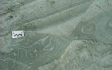
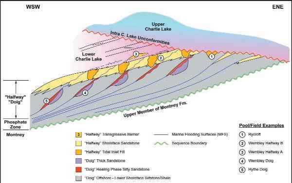
■ Is there a basin-wide unconformity associated with the Triassic Doig to Charlie Lake succession? No!
■ Is there a basin-wide unconformity associated with the Triassic Doig to Charlie Lake succession? No!
User Conference
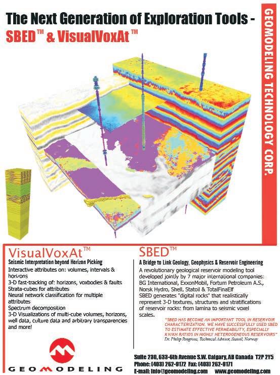
Nothing is more challenging than making the right decision, in the right place, at the right time. Nothing. The decision you make will affect the productivity, the economics and the success—or failure—of your operations, your people and your company.
CSPG OFFICE
#160,540 - 5th Avenue SW
Calgary,Alberta,Canada T2P 0M2
Tel:403-264-5610 Fax:403-264-5898
Email:cspg@cspg.org Web:www.cspg.org
Office hours:Monday to Friday,8:30am to 4:00pm
Business Manager:Tim Howard
Email:tim.howard@cspg.org
Office Manager:Deanna Watkins
Email:deanna.watkins@cspg.org
Communications Manager:Jaimè Croft
Email:jaime.croft@cspg.org
Conventions Manager:Lori Humphrey-Clements
Email:lori@cspg.org
Corporate Relations Manager:Kim MacLean
Email:kim.maclean@cspg.org
EDITORS
Please submit RESERVOIR articles to the CSPG office.Submission deadline is the 23th day of the month,2 months prior to issue date.(ie:January 23 for the March issue).
To publish an article,the CSPG requires both hard and electronic copies of the document.Text should be in Microsoft Word format and illustrations should be in TIFF format.For additional information on manuscript preparation, refer to the Guidelines for Authors published in the CSPG Bulletin or contact the editor.
COORDINATING EDITOR & OPERATIONS
Jaimè Croft
CSPG
Tel:403-264-5610 Fax:403-264-5898
Email:jaime.croft@cspg.org
TECHNICAL EDITOR
Ben McKenzie
GEOCAN Energy Inc.
Tel:403-261-3851
Email:bjmck@telusplanet.net
ADVERTISING
All inquiries regarding advertising and technical specifications should be directed to Kim MacLean.The deadline to reserve advertising space is the 23th day of the month,2 months prior to issue date.All advertising artwork should be sent directly to Kim MacLean at the CSPG.
The RESERVOIR is published 11 times per year by the Canadian Society of Petroleum Geologists.This includes a combined issue for the months of July/August.
Advertisements,as well as inserts,mailed with the publication are paid advertisements.No endorsement or sponsorship by the Canadian Society of Petroleum Geologists is implied.
The CSPG Rock Shop is an attractive and affordable way for advertisers to present their services to the CSPG Readership.Spaces are sold at business card sizes (3.5” wide by 2” high) and will eventually fill an entire Rock Shop page. For more information or to book a space please contact Kim MacLean at 403-264-5610,ext.205. The contents of this publication may not be reproduced either in part or in full without the consent of the publisher.
ARTICLES
DEPARTMENTS
Design & Layout by McAra Printing Printed in Canada by McAra
CORPORATE MEMBERS
THE CSPG GRATEFULLY ACKNOWLEDGES ITS *CORPORATE MEMBERS:
ABU DHABI OIL CO., LTD.
ARCHEAN ENERGY LTD.
BURLINGTON RESOURCES CANADA ENERGY LTD.
CALPINE CANADA
CANADIAN FOREST OIL LTD.
CONOCOPHILLIPS CANADA
DEVON CANADA CORPORATION
DOMINION ENERGY CANADA LTD.
ECL CANADA
EL PASO OIL & GAS COMPANY INC.
ENCANA CORPORATION
HUNT OIL COMPANY OF CANADA, INC.
HUSKY OIL OPERATIONS LTD.
IMPERIAL OIL RESOURCES LIMITED
LARIO OIL & GAS COMPANY
MJ SYSTEMS
MURPHY OIL COMPANY LTD.
NCE RESOURCES GROUP INC.
NEXEN INC.
NORTHROCK RESOURCES LTD.
PENN WEST PETROLEUM LTD.
PETRO-CANADA OIL AND GAS
PROVIDENT ENERGY LTD.
REEVES WIRELINE
SAMSON CANADA
SECURITY DBS
SHELL CANADA LIMITED
SPROULE ASSOCIATES LIMITED
SUNCOR ENERGY INC.
TALISMAN ENERGY INC.
TOTALFINAELF E&P CANADA LIMITED
TUCKER WIRELINE SERVICES CANADA INC.
UPTON RESOURCES INC.
*CORPORATE MEMBERS AS OF JANUARY 24, 2003
For a while now (years),there has been some discussion as to how to improve the Reservoir in order to make it more useful / interesting for its readers.As mentioned in the February issue’s Executive Comment,one idea is to go online with the Reservoir.With the vast majority of subscribers having either an e-mail account or access to the internet, this would be technically feasible and have several advantages over the hard-copy route. As drearily mundane as it may seem,not the least of these would be a significant decrease in printing and mailing costs.Currently,the Reservoir costs about $12,000 per issue.To put it another way,with about 3,500 subscribers and 11 issues,this represents about $38 per year per CSPG member.While part of this is regained from advertising revenues,it is still a large hit to the Society’s budget.Other benefits would include easier archiving and search capabilities.Sometimes the most current or only information on a particular subject is the abstract from one of the technical luncheons.
Generally speaking,however,the discussion tends to always end with “we need more technical content.” The obvious source for this technical content is the CSPG membership itself.With the thousands of geologists,geophysicists,engineers,and students involved in the petroleum industry, there is no question that somebody knows something of interest to somebody else.The lack of volunteered articles then boils down to the problems of inertia and time,as it does take some effort to put together something for publication.However,the effort expended benefits not only the membership at large but also the author as well,as peer-generated feedback will help refine the idea as presented (ever notice how ideas might change between the beginning and end of a project?).As an added benefit,it can also help establish the author as an expert on that particular topic (let’s be blunt,we’re talking future earnings here).
So here’s the deal.We,your Society,want to provide the venue for you to present your
A NOTE FROM (ONE OF) THE EDITORS
knowledge on any topic related to the petroleum industry.Because the Reservoir is not a peer-reviewed publication,there are some caveats.The articles are not expected to be the length or depth of those that might appear in the CSPG Bulletin,for example. They may potentially be more speculative or subjective in nature.They might go against common assumptions.On the other hand, they may be solid,though shorter,versions of articles being prepared for a more in-depth treatment (peer-review articles might take months to years before publication).From the service side,we would welcome case studies or articles on how to use whatever new technology that might have been recently developed.With these limits in mind, we will also welcome and solicit feedback on any articles that appear in the Reservoir.As a related note,Dr.Zeev Berger has volunteered to begin a new feature tentatively entitled “Exploration and Technology Update”.This initiative will be described in more detail in an upcoming issue of the Reservoir.
For anyone interested in submitting an article, we require a digital version of the article and illustrations.The preferred software is Microsoft Word for the text and tiff format for the illustrations.Generally speaking,a page of text is about 1,400 words and we would like to keep the individual articles to two to four pages in length (including illustrations).If there are any questions,they can be directed to either Jamie or me (our contact info is listed on the table of contents page in the Reservoir).Also,if you have any suggestions as to what topics you would like to see an article on,let us know.
Thanks for your attention and keep those cards and letters coming.
Ben McKenzie 261-3851 bjmck@telusplanet.net
EXECUTIVE COMMENT
PRESIDENT
John Hogg
EnCana Corporation
Tel:290-2533 Fax:290-2926
john.hogg@encana.com
VICE PRESIDENT
Craig Lamb
Husky Oil Operations Ltd.
Tel:750-1499
Craig.Lamb@huskyenergy.ca
PAST PRESIDENT
Bruce McIntyre
TriQuest Energy Corp.
Tel:531-8544 Fax:531-8569
bmcintyre@triquestenergy.com
FINANCE DIRECTOR
Lisa Griffith
GEDCO
Tel:303-8698 Fax:262-8632 lgriffith@gedco.com
ASSISTANT FINANCE DIRECTOR
Pauline Chung
Marathon Oil Corporation
Tel:974-7673 Fax:974-7665
Pchung@MarathonOil.com
PROGRAM DIRECTOR
Elizabeth O’Neil
Samson Canada
Tel:231-9904 Fax:233-0840 eoneil@samson.com
ASSISTANT PROGRAM DIRECTOR
Vern Stasiuk
GSC - Calgary
Tel:292-7000
vstasiuk@nrcan.gc.ca
SERVICE DIRECTOR
Lisa Sack
Burlington Resources Canada
Tel:260-1608 Fax:260-1821 lsack@br-inc.com
ASSISTANT SERVICE DIRECTOR
Wayne Dwyer
ConocoPhillips Canada
Tel:233-3727 Fax:233-5407
Wayne.R.Dwyer@conoco.com
SENIOR MANAGING EDITOR
Ashton Embry
GSC - Calgary
Tel:292-7125 Fax:292-4961
aembry@nrcan.gc.ca
CORPORATE RELATIONS
Vacant
So what exactly does the Program Director do? I know that is the question I had when I was asked to run for the CSPG Executive over a year ago.I asked a lot of questions before I agreed to take on the challenge,but the answers I received,while correct, only scratched the surface of what “Programs” and being the Program Director is all about.A year later, as I move from Assistant Program Director to the senior position,my appreciation,admiration,and understanding of the many committees to whom I provide liaison to the CSPG Executive has grown substantially.The work they do goes a long way to providing the image that the CSPG presents to our members.Here is a brief run down of who they are and what they do:
TECHNICAL DIVISIONS:
The CSPG has eleven Technical Divisions.Each touches on a specific area of geology or a specific area of geologic interest within the petroleum industry.All are chaired or co-chaired by enthusiastic CSPG members who have specific interests in these areas or specialties.The Technical Divisions reflect the diversity within our profession.Some Divisions have larger committees running and organizing them,while others only have one or two people handling things. All provide lunchtime or evening talks that specialize in the area the Technical Division represents.Some provide field trips as well,and in the near future the Hydrogeology Division is going to play a key role in the first of our new Mini-Conferences in early 2004. Last year saw the launch of our newest division –Emerging Resources – reflecting changes in the Petroleum Industry.The Sample and Core Division is tackling a number of issues,including those related to the AEUB Core Research Centre.Requirements for chip samples and the looming space crunch in terms of space for core storage have been some of the things they have been involved with.Information on all these Divisions is available on the CSPG Website or in the Reservoir,and each month you will see a different Division Profile giving you more information on each of the Technical Divisions.If you have an interest in any of these Divisions,please support them with your attendance at their talks and field trips,and please consider volunteering your time to help out –I’m sure your interest and time would be appreciated.
TECHNICAL LUNCHES:
This committee’s work has one of the highest profiles in the CSPG,as we have all come to depend on and look forward to our bi-monthly luncheon talks.This group puts together the list of speakers we enjoy for 10 months every year.Some speakers actually
A MESSAGE FROM THE PROGRAM DIRECTOR
volunteer,or come to us as AAPG Distinguished lecturers,but this hard-working group recruits many. They have recently added Web-casting of selected talks to their jobs.This provides a great opportunity for our members to see talks that they missed,or for those members outside of Calgary to benefit from this program.Right now approximately half the talks are Web-cast,but this will eventually increase to all of them.This committee not only provides members in Calgary with the latest in geotechnical thinking,but also plays a key role in our mandate to provide a more national focus for the CSPG.
CONVENTIONS:
This committee is only a few years old but already is having a huge positive impact.In the past there was no formalized way for convention organizing committees to pass their learned knowledge from one convention to subsequent organizing committees.Also,finding Convention Chairpersons fell to the CSPG Executive who already had a lot on their plate.As a result,convention planning was never more than a year or so ahead of the present.The Convention Committee was formed to change this. They provide a conduit and repository of accumulated convention knowledge and have allowed long-term convention planning to begin to take place. We now have Convention Chairpersons through 2005 and are beginning to look at some new ideas for mini-conferences and core conferences outside our regular once-a-year large convention.This will also lead to more long-term planning of joint conventions with other societies that was not possible before.
CONTINUING EDUCATION:
This is one committee that we are in the process of revitalizing.The volunteers that have been running this committee feel that it is time to move on to other things,so this committee is in need of a new chairperson(s).With the existence of the Geoscience Professional Development Centre at the University of Calgary some of the courses this committee has run in the past can be accommodated there,but many others cannot.With the demise of the “big oil company” training departments,there is still a need to train new graduates and to continue to upgrade the skills of those of us that have been doing this awhile.There are a lot of courses run by consultants that help to fill the need but there are still areas of training left unaddressed.Continuing Education is a work in progress.We are actively recruiting for someone or some people to chair this committee and if anyone has any interest in this I would really like to hear from them.Also,we need your ideas and feedback.We know from our recent survey that this is an area that is important to the membership,but are there specific things that you would like to see.My e-mail address is at the front of the Reservoir and I would be very appreciative of any and all feedback from the membership.
The Committees under the banner of Programs in the CSPG represent much of what makes the CSPG tick.Please support them with your ideas, your time,and your attendance.
Elizabeth
O’Neill Program Director
CSPG FINAL POSITION ON GLOBAL CLIMATE CHANGE SCIENCE
DEVELOPED BY D.L. BARSS, ALBERT F. JACOBS, AND ARTHUR PATTERSON. EDITED BY BRAD HAYES, CSPG PAST PRESIDENT.
In late 2002,the CSPG published a draft position on global climate change science on its website and in the Reservoir.We invited members to review this position, and to make comments and suggest improvements.
Twenty-four members responded - sixteen strongly endorsed the draft position,while eight disapproved or felt that changes should be made.Many of the dissenters felt that the CSPG was advocating an antiKyoto position.Most of the comments on both sides were thoughtful and constructive,and a few of the respondents suggested specific improvements and new website links.
We conclude that,including the unanimous approval of the Executive Committee and strong input from the Past Presidents of the Society,the CSPG membership has strongly endorsed the draft global climate position.
As a result,the CSPG is taking the following actions in formulating its final position and actions on climate change science:
■ Our position statement clearly emphasizes that the CSPG’s primary goal is a clearer understanding of the current status and complexity of global climate science.
■ We clearly disassociate the Society from taking a position on the Kyoto Accord,as we are not qualified to address the economic and political issues.
■ We have and will continue to improve our list of links on the CSPG website,in order to provide a comprehensive view of global climate change science.
THE CSPG’S POSITION ON GLOBAL CLIMATE CHANGE SCIENCE
(FINAL VERSION – JANUARY 2003)
INTRODUCTION
The CSPG has been asked by many members,and encouraged strongly by its Past Presidents,to state a position on the controversial subject of global climate change.Although the Society has traditionally avoided taking public positions,the Executive has agreed that we must take a clear stand as professionals and as knowledgeable scientists of the Earth.
Geologists should have an authoritative voice in this messy and politicized public debate,which has been marked by many misrepresentations of science and manipulation of the public media by those on every side.In particular,petroleum and other “soft-rock” geologists,who work daily with the products of earth’s varying climate over geological history,have a vital and essential perspective to contribute.We are also accustomed to synthesizing evidence from many branches of science in our day-to-day work.
Expert opinions expressed by the CSPG focus entirely on the science of global climate change,and
do not address the political and economic issues which dominate the media.The CSPG advocates no position on the Kyoto accord,nor on other public actions promoted in response to perceived climate change.We must say very strongly,however,that the science is the basis of the entire climate change debate – arguments built upon a poor understanding of the science are doomed to be wrong.
The CSPG position has been presented to the membership in draft form,and comments have been invited from all members.This final position paper reflects the input received,and has been approved by a strong majority of respondents.
Climate change scientific arguments are many and are far too involved to be reviewed in this short position paper.However,the reader is referred to the following summaries of current global climate science:
■ WMO UNEP Intergovernmental Panel on Climate Change (www.ipcc.ch/) - summaries of the findings of the IPCC,widely quoted in support of arguments linking anthropogenic gas emissions and climate change
■ “The CSPG Backgrounder to Global Climate Change”,a brief review of the key scientific issues,by CSPG member D.L.Barss and associates.This paper has been posted on the CSPG website.
■ “Are Observed Changes in the Concentration of Carbon Dioxide in the Atmosphere Really Dangerous?”,an exhaustive review of global climate science by Chris de Freitas of the University of Auckland (Bulletin of Canadian Petroleum Geology,June 2002;also posted on the CSPG website).
THE CLIMATE CHANGE DEBATE
Many people argue that “greenhouse gases” emitted by human activities have upset natural climatic balances,causing anomalous global climate change since the mid-20th century (see,for example,the David Suzuki Foundation website, www.davidsuzuki.org).Claims of “scientific consensus” backing these ideas are not wellfounded,however,as summarized in the “CSPG Backgrounder”,which draws the following conclusions:
■ Global climate change has been a constant throughout the history of the Earth,driven by a variety of global and astronomical natural factors.The variability of and interactions among these factors are the subjects of active research,but are still very poorly understood by climate scientists.Observations of past climatic variations show much better correlation with astronomical variables such as solar activity and orbital changes than they do with atmospheric CO2 levels.
■ Since the beginning of the 20th century, atmospheric CO2 has risen with accelerated production of CO2 by human activities. However,using the best attempts to remove biases from temperature data,there is not a good correlation between atmospheric CO2 and global temperatures.
■ Global circulation models attempt to represent climatic influences with numerical equations,and are used to predict future climate variations.However,they are hampered by our poor understanding of the relationships and feedback loops among many of the key variables.GCM predictions of warming trends through the 21st century have decreased systematically as the models have become more sophisticated.
■ These observations suggest that global climate change is a natural and fundamental part of earth history,and that the effects of human activities on global climate are likely a poorlyunderstood fourth-order factor.
THE CSPG’S POSITION ON GLOBAL CLIMATE CHANGE
Based on these conclusions,the Canadian Society of Petroleum Geologists proposes the following position on global climate change:
Global climate change is a natural and continual process on Earth.Climate changes similar to and much more severe than those happening today have occurred repeatedly throughout historic and geologic time,as the result of many natural factors.
Climate science is only beginning to understand these factors and their interactions.There is no “scientific consensus” that “greenhouse gases” produced by humans are driving any unusual climate changes.
Mankind’s greatest efforts to reduce production of carbon dioxide,a natural component of the atmosphere essential to virtually all life,will not significantly affect climate change.The climate will change naturally,and mankind must adapt,as all life has done throughout the Earth’s history.
Regardless of the outcome of global climate change debates,mankind should not be distracted from the worthwhile goals of using all resources wisely,and of reducing its production of polluting chemicals that are truly harmful to life on Earth.We should further develop our scientific understanding of the earth,oceans,and atmosphere,to guide us in reducing our negative impacts as effectively as possible.
Assessment of Global Oil, Gas and NGL Resources
Based on the Total Petroleum System Concept
SPEAKER
Thomas S.Ahlbrandt
United States Geological Survey, Denver,Colorado
World Energy Project Chief
11:30 am
Tuesday,March 11,2003
TELUS CONVENTION CENTRE CALGARY, ALBERTA
Please note:
The cut-off date for ticket sales is 1:00 pm,Wednesday,March 5th.
Ticket price is $25.00 + GST
Is the world running out of oil? Where will future oil and gas supplies come from? To help answer these questions,the U.S. Geological Survey in 2000 completed a new assessment of the undiscovered conventional oil and gas resources and potential additions to reserves from field growth.One hundred and twenty-eight provinces were assessed outside of the United States in a 100 man-year effort from 1995-2000.Total Petroleum Systems (TPS) were identified and described for each of these provinces along with associated Assessment Units (AU) that are the basic units for assessing undiscovered petroleum.The assessment process coupled geologic analysis with a probabilistic methodology to estimate remaining potential.Within the 128 assessed provinces were 149 TPS and 246 AU.For these provinces,the endowment of recoverable oil,which includes cumulative production,remaining reserves, reserve growth,and undiscovered resources is estimated at about 3 trillion barrels of oil (TBO).The natural gas endowment is estimated at 2.6 trillion
MARCH LUNCHEON PARTNERS
barrels of oil equivalent (TBOE).Oil reserves are currently 1.1 TBO;world consumption is about .028 TBO per year. Natural gas reserves are about .8 TBOE; world consumption is about .014 TBOE. Thus,without any additional discoveries of oil,gas or natural gas liquids,we have about 2 TBOE of proved petroleum reserves.Of the oil and gas endowment of about 5.6 TBOE,we estimate that the world has consumed about 1 TBOE,or 18 percent leaving about 82 percent of endowment to be utilized or found.Half of the world's undiscovered oil and gas potential is offshore.Arctic basins with about 25 percent of undiscovered petroleum resources make up the next great frontier. While petroleum resources in the world appear to be significant,certain countries such as the U.S.may run into import deficits,particularly oil imports from Mexico and natural gas from Canada.
Ten significant insights related to the elements of the Total Petroleum Systems that were evaluated include:(1) Petroleum is trapped in many ways,less than half of known petroleum occurs in exclusively structural traps,(2) Type II source rocks are by far the dominant source rock type and source rocks occur throughout the sedimentary rock record,(3) Mesozoic source rocks (particularly JurassicCretaceous) are the most important volumetrically,(4) Young Cenozoic petroleum systems are volumetrically dominant,and much petroleum has clearly been lost from older petroleum systems, (5) The key elements of petroleum systems are cyclic and concentrated near era boundaries,(6) Despite enormous recent success with deepwater reservoirs, volumetrically they are currently the least significant of those considered;continental reservoirs are dominant,(7) Future discoveries will be dominantly from clastic reservoirs,(8) Salt is a very effective longterm seal,and salt seals are a critical preservational component of older Paleozoic petroleum systems,(9) Most of
the petroleum systems in the world are dominated by vertical migration or limited lateral migration (less than 20 kilometers) from the mature source rock area,and (10) Many major conventional natural gas systems are closely linked to large unconventional (continuous) resources.
BIOGRAPHY
Thomas Ahlbrant is the World Energy Project Chief with the United States Geological Survey.Thomas received his B.A.and Ph.D from the University of Wyoming in 1969 and 1973,respectively.He worked with international oil firms such as Exxon,Amoco, and Amerada as well as several consulting organizations prior to his current employment with the USGS.Thomas is a recipient of numerous honors such as 2002 AAPG Distinguished Service Award,2000 University of Wyoming Distinguished Alumnus Award, 1999 RMAG Outstanding Scientist,1995-96 AAPG Executive Committee and AAPG Chairman,House of Delegates,and 1994 RMAG Best Paper.He also is the author of 175 publications on clastic depositional environments,petroleum geology,resource assessment,and petrophysics.His research emphasis is on the Middle East and Rocky Mountain areas,and on world resource assessment.
MARCH LUNCHEON
Retroarc Foreland Systems: Dynamics and Sedimentation
SPEAKER
Octavian Catuneanu
Dept.of Earth and Atmospheric Sciences,University of Alberta
11:30 am
Tuesday,March 25,2003
TELUS CONVENTION CENTRE CALGARY, ALBERTA
Please note:
The cut-off date for ticket sales is 1:00 pm,Wednesday,March 19th.
Ticket price is $25.00 + GST
Retroarc foreland systems form through the flexural deflection of the lithosphere in response to a combination of supra- and sublithospheric loads.Supracrustal loading by orogens leads to the partitioning of foreland systems into flexural provinces, i.e.,the foredeep,forebulge,and backbulge.Renewed thrusting (addition of load) in the orogenic belt results in foredeep subsidence and forebulge uplift, and the reverse occurs as orogenic load is removed by erosion or extension.This pattern of opposite vertical tectonics modifies the relative amounts of available accommodation in the two flexural provinces,and may generate out-of-phase (“reciprocal”) proximal to distal stratigraphies.Coupled with flexural tectonics,additional accommodation may
be created or destroyed by the superimposed effects of eustasy and dynamic (sublithospheric) loading.The latter mechanism operates at regional scales,and depends on the dynamics and geometry of the subduction processes underneath the basin.The eustatic and tectonic controls on accommodation may generate sequences and unconformities over a wide range of timescales,both over and under 106 yr.
The interplay of base level changes and sediment supply controls the degree in which the available accommodation is consumed by sedimentation.This defines the underfilled,filled,and overfilled stages in the evolution of a foreland system,in which depositional processes are represented by deep marine,shallow marine,and fluvial sedimentation respectively.
Underfilled foredeeps are dominated by gravity flow processes,as exemplified by the Late Permian submarine fans in the southern Karoo Basin.Each submarine fan is coeval with the progradation of a deltaic succession in the forebulge region along the distal shoreline of the interior seaway,which generates sequences composed of pelagic facies (potential source rocks) that grade laterally into foredeep and forebulge reservoirs (turbidites and deltas respectively).
Similar out-of-phase base level changes between the foredeep and the forebulge also generate distinctive stratigraphic
architectures in shallow marine and fluvial successions.The Bearpaw Formation in Alberta and Saskatchewan illustrates a filled foreland system,in which foredeep transgressions correlate with forebulge regressions and vice versa, in response to high frequency (105 yr) orogenic cycles of loading and unloading. Once the sediment supply exceeds the available accommodation,the depozone of the foreland system becomes restricted to the region that undergoes flexural subsidence at the time.This defines the stratigraphic architecture of overfilled foreland systems,in which foredeep fluvial sequences correlate with forebulge unconformities and vice versa, in response to the same cycles of orogenic loading and unloading.Fluvial sequences display predictable changes in style between higher and lower energy systems,with important implications for the distribution of reservoirs in the overfilled sections of the basin.
BIOGRAPHY
Octavian Catuneanu is an Associate Professor at the University of Alberta,with a PhD in geology from the University of Toronto.He is the recipient of a 2002 Best Paper Award of the Geological Society of America,and a specialist in sedimentology,sequence stratigraphy,and basin analysis.He is currently involved in several international research programs,and as an instructor of sequence stratigraphy workshops for conferences and oil companies from around the world.
APRIL LUNCHEON
The History of a New Play: Thunder
Horse Discovery, Deepwater Gulf of Mexico
SPEAKER
Cindy A.Yeilding BP,Houston,Texas
11:30 am Thursday,April 10,2003
TELUS CONVENTION CENTRE CALGARY, ALBERTA
Please note:
The cut-off date for ticket sales is 1:00 pm,Monday,April 7.
Ticket price is $25.00 + GST
The Thunder Horse discovery is an accumulation of over one billion barrels of oil in the deepwater Gulf of Mexico.This test challenged traditional exploration philosophies in the GoM and led to the discovery of a new play.After early success in the amplitude-driven deepwater play, pool sizes were declining and success rate was flat at best.After multiple exploration failures in the conventional attributedriven play,we adopted a 'back to basics' exploration philosophy which focused on the geologic elements of the basin.We also focused on exploring from the source rock up.These concepts changed the way we viewed prospectivity in the GoM and steered us towards targeting older
The cut-off date for ticket sales is 1:00 pm,Monday,April 21. Ticket price is $25.00 + GST
stratigraphic intervals in previously untested deeper structures.
Regional work indicated that the Mississippi Canyon protraction area was a top place to focus our exploration efforts. Existing discoveries proved the presence of a world-class petroleum system and showed that large structures with significant fetch areas were present.Our subregional analysis focused on highgrading structural features with the best fetch areas and well-developed reservoir. The analysis indicated that the Boarshead Basin in south central Mississippi Canyon held promise as a top area to test this new play concept and two structures were prepared for testing.Both prospects were turtle structures with primary targets in Miocene strata.
Before we could drill,several major hurdles had to be overcome.The acreage position had to be secured,and rigs with the ability to drill in these water depths had to be obtained.Three-D seismic surveys and depth-imaging breakthroughs were required to describe the prospect elements and position a well.Depth imaging was especially important,as it provided a much better structural image for prospect description and well positioning.When we finally tested the two top prospects in the play,one (Thunder Horse) was successful and one (MC 911-1) was a failure.Post-appraisal of these wells helped us understand the
potential and risks of this new play, although each new well in the play continues to teach us new lessons and keep us humble.
The process of continued focus has led us to this success.In building a regional framework for the northern Gulf of Mexico basin,we were able to focus our subregional analysis on interpreted sweet spots that we were constantly highgrading.While the regional and subregional work were very efficient in terms of cost and time,prospect maturation and drilling were extremely cost- and team-intensive.
BIOGRAPHY
Cindy Yeilding earned her MSc in 1984 from the University of North Carolina.She has been employed by BP for 18 years and is currently the Global Geoscience Technology Manager for the Upstream Technology Group in Houston,Texas.She has developed and led short courses and field seminars in deepwater clastic systems in the US and Canada,salt/sediment workshops,and basic petroleum geoscience.She has also chaired numerous AAPG sessions,presented over 20 AAPG/SPE/GCSSEPM talks,and participated in Hedberg conferences.Her primary research has been in salt sediment interactions and her recent focus has been in exploration of deepwater clastic deposystems,with development,access,and testing of new plays.
Antarctica has controlled glacial eustasy throughout most of the Neogene.This talk will provide a review of the evidence for Antarctic glaciation in the Cenozoic and a discussion of the glacial eustatic control on global stratigraphic architecture.The most recent glacial eustatic cycle,which is by far the best documented,is used to understand those factors that regulate ice sheet expansion and decay.In summary,future changes in the volume of the ice sheet and its potential impact on civilization by coastal flooding are discussed.
BIOGRAPHY
John B.Anderson graduated in 1968 with his B.S.in Geology from the University of South Alabama.He then went on to receive his M.Sc.in Geology from the University of New Mexico in 1970 and he received his Ph.D.in
Geology from Florida State University in 1972. John was an Assistant Professor at Hope College in Holland,Michigan from 1972 to 1975.Since 1975,John has been a professor at Rice University in Houston,Texas where he has held various positions including Department Chair from 1992 to 1999.John is currently the Maurice Ewing Professor of Oceanography.
John is involved with the study of Marine Geology and Sedimentology in Antarctica as well as the Quaternary Evolution of the Northern Gulf of Mexico Basin.These studies have involved 21 scientific expeditions to Antarctica and the Gulf.John is involved with the AAS-Polar Research Board,AGU-Antarctic Research Series,the AAPG,and is currently President-elect for the Society for Sedimentary Geology.John has also authored and co-authored 120 refereed publications and three books.
ROCK SHOP
COURSE ANNOUNCED: PETROLEUM EXPLORATION
IN FOLD & THRUST BELTS - GEOLOGICAL PRINCIPLES & PRACTICES
By Peter B. Jones
April 29-May 2 in Calgary, AB
For geoscientists, engineers and managers working in domestic and foreign deformed belts. For information call: Judith at (403) 264-0173 or E-mail: judith.lentin@thementors.com
Employment Opportunities
Dalhousie University, Geodynamics Group Department of Oceanography
Halifax, NS B3H 4J1
Research Associate* and Team Leader Lithospheric Extensional Processes (*Requires PhD and Postdoctoral experience). See website for further details: http://adder.ocean.dal.ca/ for information and deadline.
Applications to: Dr. Chris Beaumont chris.beaumont@dal.ca; FAX: 902-494-3877 Please include: CV, Canadian Status (Canadian, permanent resident, or not), evidence of qualifications (see website), and three letters of recommendation.
STRUCTURAL DIVISION
A “Pop-Up”
Structure
Preserved Near the Leading Edge of the Foothills, Blairmore Map Area (82G/09E),Alberta
SPEAKER
Glen S.Stockmal Natural Resources Canada, Geological Survey of Canada (Calgary)
12:00 Noon
Thursday,March 6,2003
+30 (3rd floor) ConocoPhillips Conference Centre (inside Sunterra Market), Gulf Canada Square, 401 - 9th Avenue SW. Calgary, Alberta
Recent mapping in the Blairmore easthalf map area (Stockmal and Lebel,GSC Open File in preparation) has delineated a “pop-up” structure transected by the Crowsnest River.At scenic Lundbreck Falls,the sub-horizontal attitude of the Virgelle Formation (Milk River Group) is unusual in comparison to fault-bounded slices to both the east and west,where
strata display steep to moderate dips more typical of Foothills structures.The relatively broad (750 m across strike) flat-lying panel exposed at Lundbreck Falls is bounded downstream to the east by a foreland-directed thrust fault placing Virgelle Formation on Lundbreck Formation (Belly River Group).To the west,this panel is overridden by a steeply west-dipping foreland-directed thrust carrying Milk River and Belly River strata in its hanging wall. Stratigraphic offset across this thrust fault is apparently small to negligible at the Crowsnest River,but increases markedly at higher elevations to the north.Map and stratigraphic relationships suggest that,at the river and adjacent low elevations,the subhorizontal panel is actually bounded to the west by a cryptic west-directed backthrust that is overridden up-slope by the foreland-directed fault just described.These features comprise a “pop-up” structure,similar to those interpreted elsewhere within the triangle zone in the subsurface.The inferred backthrust is not alone in this area.Two kilometres downstream,the well-exposed section of Milk River
HYDROGEOLOGY DIVISION
Use of formation water chemistry to aid oil exploration in southeastern Alberta
SPEAKER
Colleen Wendeborn University of Calgary
12:00 Noon
Friday,March 28,2003
(note change from the normal day)
Encana Amphitheatre 2nd Floor, east end of the Calgary Tower Complex 1st St. and 9th Avenue SE, Calgary, Alberta
The chemical and isotopic composition of formation waters is of growing importance in oil exploration.The mapping of these compositions can be an aid to indicating the degree of communication between formations,the degree of influence of non-formation waters,and possible structural controls. Geochemical maps may also outline areas of bacterial activity,indicating heavier oils.A project was undertaken to map a specific area within the Palliser block of southeastern Alberta;the smaller area is bounded by townships 12 - 23,and ranges 10 to 18W4. Geochemical compositions were mapped for the Upper Mississippian,the Basal Quartz of the Lower Mannville,and
Group strata at the popular “Lundbreck transition outcrop” lies in the east limb of an upright anticline.The hinge of this fold is removed to the north by another east-dipping,west-directed backthrust.
BIOGRAPHY
Glen received his education at the University of Manitoba (B.Sc.(Hons)),the University of Calgary (M.Sc.),and Brown University (Ph.D.).He has undertaken structural mapping in western Newfoundland,southern Alberta,and northeastern B.C.,and has active interests in thrust-and-fold belt mechanics and linkages with erosion and sedimentation.He has been a research scientist with the GSC since 1985.
INFORMATION
There is no charge.Non-members of the CSPG are also welcome.Please bring your lunch.Deserts are provided by Norwest Laboratories.Beverages are provided by HEF Petrophysical.For details or to present a talk in the future,please contact Luc Lalonde at 403201-4344,e-mail:lklalond@telusplanet.net or Eric Hanson at 403-233-3250,email: Eric.S.Hanson@conocophillips.com
the Glauconitic of the Upper Mannville. It is known that formation waters have a distinct chemical signature,and the changes in composition from formation to formation will be discussed,as well as the possibility of an isotopic signature for formation waters.Also,possible structural controls on the distribution of formation water composition will be briefly examined.
INFORMATION
The luncheon talks are free and open to the public.Please bring your lunch.Refreshments are provided by Norwest Laboratories and Encana.For further information,or to present a talk,please contact Stephen Grasby at (403) 292-7111 or sgrasby@gsc.nrcan.gc.ca.
EMERGING PETROLEUM RESOURCES DIVISION
Unconventional Gas Shales: U.S.Experience and Outlook for Canada
SPEAKER
J.Michael Gatens
Chairman & CEO,MGV Energy Inc.
12:00 Noon, Wednesday,March 12,2003
+30 (3rd floor) ConocoPhillips Conference Centre (inside Sunterra Market), Gulf Canada Square, 401 - 9th Avenue SW. Calgary, Alberta
Presentation will summarize the history of the gas shales experience in the U.S.and provide an early outlook for gas shale resource potential in
the WCSB.Gas shales are the third leg of the major unconventional gas plays in the U.S.,the others being CBM and tight sands.In 2000,U.S. gas shales produced over one bcf/d from over 17,000 wells.Major shale plays reviewed will include the Devonian Shales of the Appalachian Basin,Antrim Shale of the Michigan Basin, Barnett Shale of the Ft.Worth Basin,and the New Albany Shale of the Illinois Basin.Other emerging plays will also be discussed briefly. Basic reservoir characteristics will be summarized as well as completion and production practices that have evolved for these shales.A brief overview of the major potential gas shales in the WCSB and the gas resource potential will follow the U.S.shales discussion.
BIOGRAPHY
J.Michael Gatens is Chairman and CEO of MGV Energy,Inc.,the Canadian subsidiary of
BASIN ANALYSIS DIVISION
Lowstand Fans of the Permian Basin
SPEAKER
Bruce Hart
McGill University
12:00 Noon Friday,March 14,2003
Room 17G, West Tower Petro-Canada Centre 150 - 6th Avenue SW Calgary, Alberta
Permian rocks of the Brushy Canyon Formation (Guadalupian) and the underlying Bone Spring Formation (Leonardian) are excellent examples of reciprocal sedimentation.Carbonate sedimentation dominated during sea-level highstands,whereas during lowstands siliciclastic sediments were delivered to the exposed shelf margin and subsequently redistributed to fans on the slope and basin floor.The integration of 3-D seismic and wireline data,supplemented by outcrop observations,leads to insights in terms of understanding:a) the controls on lowstand fan development and b) how similar deposits may be recognized and analyzed elsewhere. Sedimentation patterns in the Brushy Canyon and Bone Spring were affected by seafloor
relief,with sands preferentially accumulating in paleobathymetric lows on the slope and basin floor.Although sediment appears to have been supplied to the shelf margin via a line source, forming a slope apron,intraslope basins acted as local depocenters.Further out on the basin floor,sandy channel fairways generally follow paleobathymetric lows.The thickness of lowstand fans is variable.Fans in the Bone Spring may locally be over 100 m thick and show well-developed facies architecture that may be imaged with well logs or seismic data. One of the fans is much thinner (generally < 10 m),presumably a result of sediment supply and/or duration of the lowstand.This thin fan does not show the same internal stratigraphic architecture on logs,and is a seismic thin bed. Case studies will show the seismic and log expression of these features and how log, seismic,and production data may be integrated to:a) understand the controls on their origin and b) map reservoir properties of interest.
BIOGRAPHY
Bruce Hart is an Assistant Professor at McGill University.His research focuses on the use of 3-D seismic data in reservoir characterization programs. Prior to joining McGill in the Summer of 2000,he held positions with the New Mexico Bureau of Mines,Penn State,and the Geological Survey of Canada.His website (http://eps.mcgill.ca/~hart) describes his teaching and research activities.
Quicksilver Resources Inc.(KWK:NYSE).Mr. Gatens is a Distinguished Member of the Society of Petroleum Engineers (SPE) and has spent most of his career evaluating and developing unconventional gas resources throughout the world.He authored or co-authored numerous technical reports,papers,and presentations on gas shales as a principal investigator on various Gas Research Institute (GRI) shale research projects and is currently leading MGV’s unconventional gas efforts in the WCSB.
INFORMATION
All luncheon talks are free – please bring your own lunch.If you would like more information about future EPRD activities,please join our e-mail distribution list by sending a messages with the title “EPRD list”to caddelem@bp.com.
INFORMATION
BASS Division talks are free.Please bring your lunch.For further information about the division, joining our mailing list,a list of upcoming talks,or if you wish to present a talk or lead a field trip, please contact either Steve Donaldson at 403645-5534,email:Steve.Donaldson@encana.com or Mark Caplan at 403-691-3843,email: Mark.Caplan@shell.ca or visit our web page at www.cspg.org/basin_analysis.html.
KEEPING TRACK
SCOTT GARDINER
New: General ManagerInternational New Ventures Nexen Inc., Calgary
Pr evious: Manager - Yemen Business Development Nexen Inc., Calgary
SEDIMENTOLOGY DIVISION
Plio-Pleistocene Lacustrine to Fluvial Deposits in the Turkana Basin,Northern Kenya:Sedimentology and Ichnology of HominidBearing Strata
SPEAKER
Robert E.Lamond
Imperial Oil Resources
12:00 Noon, Friday,March 21,2003
Encana Amphitheatre
2nd Floor, east end of the Calgary Tower Complex
1st St. and 9th Avenue SE, Calgary, AB
The stratigraphic record of the Turkana Basin in northern Kenya reflects an extremely dynamic paleogeography characterized by numerous transgressions and regressions of vast lakes that occupied this region during the past four million years. Understanding the paleoenvironmental and paleogeographic fluctuations that occurred here is of great interest because of the very
significant fossils of human ancestors (both Australopithecus and Homo) that have been discovered in these sediments bordering modern Lake Turkana.
Diverse,recurrent associations of trace fossils (ichnofacies) and biogenic sedimentary fabrics (ichnofabrics) occur in fluvial and lacustrine sandstone,mudstone, and limestone facies of the PlioPleistocene Nachukui Formation.The trace-fossiliferous strata represent facies ranging from ephemeral,braided,and meandering stream paleoenvironments to lake margin beach,lagoon,and shallow offshore paleoenvironments.
While locally abundant and well-preserved, trace fossils are sparsely distributed stratigraphically and spatially throughout the Turkana Basin.Although individual ichnofacies typically exhibit low diversities consisting of only a few ichnogenera,there are many different ichnofacies and ichnofabrics preserved,representing various paleoenvironmental settings.The environmental factors that control the distribution of the trace fossils include sediment composition and texture,current
and/or wave energy,water chemistry,and water saturation of the sediment.Seven local,paleoenvironmentally controlled ichnofacies can be recognized:Termitichnus, Taenidium-Palaeophycus,SkolithosArenicolites,Teichichnus,Sertaterebrites, Lockeia,and Piscichnus ichnofacies.In addition,several distinctive ichnofabrics, including mammal trample beds and rhizolith-rich beds,can be discerned.
These ichnofabrics provide biostratigraphic, paleoecological,and paleoenvironmental insights into the history of this basin,and give us a hint of what the conditions may have been like for the early hominids occupying this area two to four million years ago.
INFORMATION
Please note that there has been a venue change. Talks are free – don’t forget to bring your lunch!
For more information about this talk,or about presenting a talk,please call Scott Leroux at (403) 645-2419,(email: Scott.Leroux@EnCana.com).
DIVISION PROFILE - INTERNATIONAL DIVISION
The International Division has been running since the early 1990’s.The Division mandate is to provide a CSPG forum for members who are interested in learning more about the geology and hydrocarbon potential of countries other than Canada.This is achieved by holding regular technical presentations.
The technical presentations vary between offering detailed investigations of specific basins or hydrocarbon provinces to more general overviews of a particular country. The talks always aim to offer some general interest geology (including elements of sequence stratigraphy,basin formation, structural geology,etc.),general interest
geography,and personal insights on the cultural aspects of other countries.Also included are thoughts on the philosophy and economic imperatives of doing business in foreign places.
Our meeting schedule is to have one informal brown-bag talk every month except during the summer.Talks normally start at 12:00 noon and finish before 1 pm. Each talk consists of a 40 minute technical presentation followed by a ten minute question period.Currently,our meetings are held on the second floor of the Calgary tower in the EnCana Amphitheatre.
Involvment of our CSPG members is the key to the success of the Division.Individuals are ecouraged to take part in all activities. Service companies and students are also encouraged to attend Division meetings.
The Division Chair is Geoffrey Say,of ECL Canada.If you are interested in joining our mailing list and learning more about the International Division,or if you care to suggest a technical topic or present a talk to the division,please contact Geoff at (403)263-0449 or g.say@ecqc.com.
“FOSSILS IN MOTION” SIXTH ANNUAL PALAEONTOLOGICAL SYMPOSIUM
Unconventional Gas Shales: U.S.Experience and Outlook for Canada
Mount Royal College Science Wing (Lower Level), 4825 Richard Road SW, Calgary, Alberta
Saturday,March 15,2003
10:00 am
Relationships and functional morphology of Walliserops,a peculiar Devonian trilobite genus from Morocco
Kevin Brett,University of Alberta
10:30 am
Footprints in the Sands of Time:Tracking the earliest animals on land
Dr.Rob MacNaughton, Geological Survey of Canada
11:00 am
Sauropod body shapes & narrow and wide gauge trackways
Donald Henderson,University of Calgary
11:30 am
Snakes with Legs
Dr.Michael Caldwell,University of Alberta
12:30 pm
Poster Viewing (Presenters to be available)
2:00 pm
Jurassic Dinosaur Tracksites, American Southwest
Debra Mickelson,University of Colorado
2:30 pm
What's your sign beautiful? At 200 dB: Sexual Selection in Giant Sauropod Dinosaurs
Eric Snively,University of Calgary
3:00 pm
Fossil tracks from Tumbler Ridge:a brief history of collaboration between amateurs and academics
Richard McCrea,University of Alberta
3:30 pm
Dinosaurs in the Deep:The sinking of the SS Mount Temple and Related Military Histories
Darren Tanke,Royal Tyrrell Museum (Keynote talk)
WORKSHOPS
Room B108
Sunday March 16th
9 AM to Noon
Fossil Plants of Alberta: Precambrian to Tertiary INSTRUCTOR
Georgia Hoffman
1 PM to 4 PM
Functional Morphology of Vertebrates: Interpreting the Skeleton INSTRUCTOR
Dr.Anthony Russell, University of Calgary
Sunday workshops restricted to those who register and pay the associated workshop fees. To register please contact Vaclav Marsovsky at vaclav@telusplanet.net or phone 403-5470182.Workshops are $15.00 each to cover cost of handouts or a special reduced fee of $25 for those attending both.These fees are used to offset the expense of the workshops and symposium.
FURTHER INFORMATION
The symposium is free and open to the general public. Fossil displays and a fossil identification booth will also be part of the event.To present a poster,volunteer,or for more info contact Philip Benham at (403)-6913343 or email programs@albertapaleo.org.
Visit the APS website for confirmation of event times and upcoming speakers:http://www.albertapaleo.org
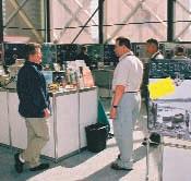
STAFF PROFILE: TIM HOWARD – BUSINESS MANAGER
Tim Howard has been the CSPG Business Manager (BM) since December 5,1995.Prior to joining the CSPG,he served as Development Officer with the Royal Tyrrell Museum of Palaeontology for 2 1/2 years and,prior to that, was with the Canadian Armed Forces for 21 years. His last post was as Senior Project Officer on the Museum Of The Regiments development program from 1978-1981.Tim’s service in the military included both time with the Princess Patricia’s Canadian Light Infantry as an infantry officer and on submarines as a naval officer.He graduated from the Royal Military College of Canada in 1974 with a Bachelor’s degree in History.Over the years,Tim has been active in biathlon in Canada and,in the early 80’s,competed on Canada’s national team and coached several battalion teams to Army championships.He is married to Louise and has five children and three grandsons.
As BM for the Society,Tim’s primary roles include ensuring the smooth operation of the organization’s day-to-day activities and its financial well-being.With the creation of the BM’s position, the Executive Committee moved away from being an ‘operational’ body to a ‘strategic’ one,focusing on the long-term management of the CSPG.Early changes included reorganization of the Society along functional lines to reflect the needs of the membership:Executive,Programs,Services, Communications,Finance,and Operations.Handin-glove with this structural change,the Society centralized the accounting of the Society and
established a committee-driven budgeting system that provided reliable and current information on which the Executive could base planning decisions and stabilize the Society’s cash flow.Tim’s responsibilities include development of the annual budget,management of the Society’s investments, and preparation for the annual audit in concert with the Finance Committee,and assisting the ongoing development of the Strategic Business Plan.
Operationally,Tim serves as ‘adjutant’ to the Executive Committee-coordinating meetings, preparing agendas and minutes,and developing reports and proposals.Additionally,he provides the continuity of liaison,intramurally,with the Society’s 45 committees and,externally,to many of our sister societies and agencies.Tim also works very closely with the CSPG Educational Trust Fund,supporting their accounting and fundraising.Within the office itself,Tim supervises and administers the three office staff and Corporate Relations contractor,is responsible for staff delivery of services plus operations and maintenance of the office itself,the Society’s legal and insurance needs,and federal reports and returns related to both the CSPG’s non-profit status and the ETF’s charitable status.
The role of the office is to provide administrative support to the Society’s many committees, enabling volunteer members to focus on delivery of top-notch technical programming for the membership.The growth of office staff is a direct
reflection of this focus.Stabilization of logistical functions has had a meritorious effect in communications,conventions,finance,and,most recently,corporate relations.As integration of more and more of the Society’s data management functions takes place through the office,the Society will be better able to track and benefit from the inter-relationships already in existence throughout the operations and services of the CSPG.Tim’s personal goal is to ensure that the CSPG staff provides service second-to-none.
Deanna Watkins,Programs and Services Manager and Tim Howard,Business Manager,enjoying a beautiful morning in the CSPG Centre.
2003 CSPG / CSEG CONVENTION CALL FOR VOLUNTEERS
Enthusiastic volunteers are welcomed to contribute in the success of the 2003 CSPG/CSEG Convention.Individuals will be needed shortly for activities prior to the convention and numerous volunteers will be required for specific duties during the convention.Previous experience is welcome but not a prerequisite.Industry, academia and student bodies are all encouraged to join.
If you are interested please complete the online Volunteer Form located on the Convention Website via www.cspg.org or www.cseg.ca
Convention activities that need volunteers include:
Registration
Ice Breaker and Other Receptions
Technical Program
Luncheons
Core Conference
For more information please contact Karen Greengrass,Marketing / Publicity Co-Chair and Volunteer Coordinator at 403-6806985 or greengrasskaren@shaw.ca
Join in the fun! Network with new friends and colleagues while adding to the success of the 2003 CSPG / CSEG Convention. SPECIAL BENEFITS FOR
2003 CSPG / CSEG CONVENTION CORE CONFERENCE
The 2003 Core Conference will be held at the AEUB Core Centre on June 5th and 6th.Cores will be showcased from the last decade of discoveries in frontier and international areas,as well as, conventional areas of Alberta,B.C.,and Saskatchewan.Authors will be presenting new ways of exploring for oil and gas through valuable geological and geophysical partnerships.
Conventional or heavy oil, shallow or deep gas,close to home or across the globe, there will be something for everyone.
Once again audio-visual cameras will be used for easy viewing of cores and cuttings during author presentations. Various international core presentations will be shown on a large screen.
During the Core Conference,refreshments will be provided by Core Labs and lunches will be provided by Hycal.The ever popular Core Meltdown / Wind-Up Party will follow the final presentation on Friday,June 6th.This special event will host the award presentations for Best Paper,Poster,Core as well as Best Student Paper,Poster and Core.
We hope you will attend the Core Conference and join with your friends
and colleagues as we wind up the 2003 CSPG / CSEG Convention - PARTNERS in a New ENVIRONMENT at the AEUB Core Centre.
2003 CSPG / CSEG CONVENTION SPECIAL EVENTS
ATTENTION STUDENTS
Longtime Members Reception
Please join us for a reunion of old friends and the re-kindling of old memories at this year’s Longtime Member Reception.The
event is open to CSPG members with 30+ years of membership.Come out and catch up with colleagues at a special reception just for you! This popular event is by invitation only and all longtime members
will be receiving an invite in the coming months.The reception will be held on June 3rd from 4:00-6:00pm at the RoundUp Centre (room TBA) and you do not need to be a convention delegate to attend.If you have any questions,or do not receive your invitation,please contact Nathan Humphrey at 233-3205 or email at Nathan.C.Humphrey@ConocoPhillips.com
Student/Faculty/Industry Reception
This is a casual event FREE of charge for student delegates to meet with faculty, industry representatives,and students from other universities.Industry and academia will have the opportunity to meet the talented and energetic minds of tomorrow;students will have the opportunity to network and have a great time discovering what’s new in the oil and gas industry! The reception will be of benefit for all who attend – helping industry make good recruiting decisions, giving faculty the chance to socialize with former and future pupils,and providing students with the chance to jumpstart their careers or pursue graduate school opportunities! The event will be held Wednesday,June 4th, from 4:00-6:00pm (room TBA).For more information,please contact Gillian Stoyko at 770-4646 Ext 3082 or email at gillian.stoyko@ihsenergy.com
2003 CALENDAR OF EVENTS
DATE: March 12-13,2003
EVENT: History of Geophysics,The Geological Society
LOCATION: The Geological Society Burlington House,Piccadilly,London
INFORMATION: The History of Geology specialist group ofThe Geological Society,London,UK,is holding a meeting on history of Geophysics atThe Geological Society Burlington House, Piccadilly,London on 12-13th March 2003.Offers of papers should be sent to the convener,Professor Richard J.Howarth,Department of Geological Sciences, University College London Gower Street London WCIE 6BT,England Email:r.howarth@ucl.ac.uk
DATE: April 6-10,2003
EVENT: SAGEEP 2003
LOCATION: San Antonio,Texas
INFORMATION: The Environmental and Engineering Geophysical Society (EEGS) invites you to submit a paper for presentation at the 2003 Symposium on the Application of Geophysics to Environmental and Engineering Problems (SAGEEP 2003). In addition to world-class oral and poster presentations on the application and recent developments in applied geophysics,there will be a suite of workshops,as well as an exhibition showcasing geophysical products and services. For more information on EEGS please visit our site at www.eegs.org.Please submit abstracts electonically to the SAGEEP 2003 Technical Chair,Cathy Skokan at cskokan@mozart.mines.edu
DATE: April 27,2003
EVENT: Saskatchewan Geological Society Core Workshop LOCATION: Industry and Resources Core Laboratory 201 Dewdney Avenue East,Regina,Saskatchewan
INFORMATION: Theme: Characterization of Horizontal Well Reservoirs Registration Fee: Cheques or money order only - No Credit Cards,Cdn $75 (includes Core Workshop volume) Students Cdn $30 (Core Workshop volume extra) Please Note: Payment should be made out to the Saskatchewan Geological Society,and sent to Saskatchewan Geological Society,P.O.Box 234, Regina,Saskatchewan,S4P 2Z6. For more information please call: Melinda Yurkowski:Phone:(306) 787-0650,Fax:(306) 787-4608, E-mail:MYurkowski@ir.gov.sk.ca
DATE: April 27-29,2003
EVENT: Eleventh Williston Basin Horizontal Well & Petroleum Conf. LOCATION: Delta Regina Hotel,Regina, Saskatchewan,Canada
INFORMATION: Informal talks;poster discussions; and workshops on geology, engineering;and geophysics pertaining to new developments in petroleum exploration and production within or applicable to the Williston Basin.For information call 306-787-7662 (Canada) or 701-328-8000 (US).
DATE: May 11-14,2003
EVENT: AAPG Annual Meeting
LOCATION: Salt Lake City,Utah
INFORMATION: For more information please visit www.aapg.org
DATE: June 2-6,2003
EVENT: 2003 CSPG/CSEG Annual Convention“Partners in a New Environment”
LOCATION: Round Up Centre,Stampede Park,Calgary,Alberta
INFORMATION: For more information please contact Lori Humphrey-Clements
Tel:403-264-5610
Email:lori@cspg.org
DATE: August 10-14,2003
EVENT: GeoSciEd IV:Earth Science for the Global Community LOCATION: Calgary,Alberta
INFORMATION: The fourth international meeting for earth science teachers from elementary to university level,and for earth scientists who deliver educational outreach programs through their communities,museums,or science centres.The purpose is to share ideas and concepts in earth science education and in the development of programs that lead to an integrated understanding of the Earth.The innovative technical program will include keynote addresses,workshops,and oral and poster sessions.Field trips will visit many worldrenowned sites of interest including the Rocky Mountains,the Burgess Shale,the Royal Tyrrell Museum of Paleontology,the Frank Slide,and the Athabasca Glacier. Please visit www.geoscied.org for details.
Please visit www.cspg.org to download or print the monthly version of the calendar of events.
JACK PORTERVIGNETTES OF CANADIAN PETROLEUM GEOLOGY
Continued from the February Reservoir
Following the disbandment of the United States’ Petroleum Administration of War in late 1946,Max Ball was appointed Director,Oil and Gas Division,Department of the Interior in early January,1947.In this capacity he served as a liaison between government and industry until December,1948,at which time he resigned his office to reenter private practice.
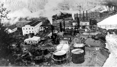
The destruction by fire of the first Abasand Oils facility in November,1941,had given the operators time to reevaluate and remedy the financial,technical,and logistical problems that had plagued their attempts to attain commercial viability,but to no avail.A rebuilt plant commenced the following year but,it too,was unable to reach anticipated productions goals.It was at this juncture that the Dominion Government reached an agreement with Abasand Oils to take over its plant which was located on Dominion Crown Land.Max Ball had no other recourse but to relinquish the operatorship of Abasand’s plant in the spring of 1942.General Engineering had been contracted by the Government to redesign and rebuild the existing plant as a pilot operation.The reality of the transfer was in effect face-saving,albeit Ball had assumed that he and his management team, including advisor Sydney Ells would continue to provide input into the refurbished plant’s operations.However,Ball’s anticipated scenario was not to be.According to Comfort (Darlen J.Comfort,1980,The Abasand Fiasco,pp.82,100),Ottawa’s Oil Controller appointed a new plant manager from its staff and planned for General Engineering personnel to be engaged in operating the pilot plant.Suffice to say,the new role to be played by the replacements was certain to create feelings of frustration and antagonism amongst Abasand’s former staff.To acerbate the impending problem, McClave’s hot water separation process was to be eliminated and an alternate process, utilizing mineral flotation cells,substituted.
Abasand’s pilot plant,with a projected processing capability of 600 tons per day, commenced operations in September,1944. According to Sydney Ells,some 19,500 tons of bituminous sand was treated by June 15 of the following year.It was on the latter date that the recently completed 500 barrel per day separation unit,as well as ancillary equipment,was destroyed by fire (Comfort, pp.122-124).
be
from the initial
at the loading
the large building to the left of centre which housed the separation unit.this plant,financed by the Dominion Government as a wartime measure,commenced operation in September, 1944 but was incapable of attaining its projected output of 600 tons per day of bitumen.In 1948 the Alberta Government also financed the building of a 500 ton per day plant at Bitumount utilizing K.A.Clark’s hot water process.it too was short-lived.Credit:National Archives of Canada.Used with permission.
The second destruction by fire of Abasand’s Horse River plant accorded its death toll. WWII had come to an end and the Dominion Government had lost interest in the project.It had been initiated as a wartime measure in the interest of national security.No doubt the government’s financial injection into the project became a matter of concern considering the disappointing results of the scheme.Undaunted,Abasand Oils approached the Government to jointly rebuild its Horse River plant.It was proposed to be refinanced on a matching basis,utilizing the $350,000 insurance award that Abasand Oils had received,but the Government was not interested in any further involvement. Abasand Oils’ tenacity could be considered an attempt to emulate the mythical legend of the Phoenix.
Despite Max Ball’s preoccupation,in the early years of the Great Depression with his attempts at raising venture capital for his proposed Abasand Oils’ extracting, separating,and upgrading facilities at the Horse River Reserve,he was able to prepare a paper on the Athabasca bituminous sand,which he presented at the American Association of Petroleum Geologist’s annual convention held in Oklahoma City on October 26,1934.The paper was entitled:Athabasca Oil Sands: Apparent Example Of Local Origin Of Oil.
It was the first comprehensive report by an industry entrepreneur in which the areal extent,oil (bitumen) content,and genesis of the deposits were theorized.
Utilizing Fort McMurray as a reference point, Ball delineated the probable northward extent of the Athabasca bituminous sand down the Athabasca River where the sand disappears below younger Cretaceous beds. He defined the eastern limits,up the Clearwater River,by the erosional edge of the McMurray Formation.Ball delimited the bituminous sand’s southwesterly expression, some 40 miles up the Athabasca River,where it is covered by younger strata.Most significantly,he recognized its continuity in the subsurface,some 80 miles to the southwest,by the bituminous sand’s presence in the Dominion Government’s Pelican Portage well which had been spudded in 1897 (now recognized as the discovery well for the Portage gas field). Based on these parameters,Ball circumscribed an area of 10,000 square miles which he postulated was underlain by bituminous sand.He further speculates that should the saturated sand extend 20 miles south of the Pelican Portage well and 80 miles to the west of the exposed deposits, that:“It appears then,that saturated sands underlie at least 10,000,probably 20,000,and possibly 30,000 or more square miles”.
Aerial view of Abasand Oils’ plant taken June 15,1945;the date it is reported to have been destroyed by fire. Apparent cloud in upper right left background marked “X” on photograph may
smoke
blaze.the fire commenced
ramp adjoining
In his discussion,relative to the varying habitat of bitumen associated with the deltaic sedimentology,characteristic of the McMurray Formation,Ball deduced a total saturation range,relative to the Formation, of 80 to 240 million barrels.Ball considered that only 15 to 20 percent of the McMurray Formation contained bituminous sand,a conclusion presumably derived by S.C.Ells of the Dominion Mines Branch from the results of his extensive surface sampling and core-drilling.
In terms of the genesis of the bitumen hosted by the McMurray Formation,Max Ball advanced a theory that negates long-distance migration.He believed it to have originated in situ and that:“The oil sands seem to lie too flat to have induced migration” and further,“In all likelihood this is not an old oil that has lost its lighter constituents,but rather a young (immature) oil that has never been geologically gently cracked or decomposed into lighter and heavier fractions”.Moreover,in reference to the McMurray sand as a regional conduit for long-distance migration:“It apparently disappears toward the west and south,at least as a continuous sand body,and is apparently not continuous with any sand that underlies the greater part of the geosyncline”.With this, he negates the theories previously advanced in published works and expounded by his geological colleagues.
To be continued.
CSPG VOLUNTEER COORDINATOR
If you are looking for a volunteer opportunity within the CSPG,Blythe will be happy to help you find your volunteer niche.
She can also provide information about any of the Society’s numerous committees if you require it.
Blythe will also assist with finding replacements for current committee volunteers who need a change and help them to find different volunteer opportunities in the Society,if desired.
Blythe Lowe can be reached in Calgary at 403-290-3516.Give her a call!
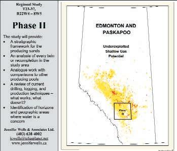
Regional Study T23-37, R22W4–8W5
Ask about our field trip in August!
Phase II
The study will provide:
• 14 regional cross-sections from surface casing to the 1st White Specks.
• An analysis of every twin or recompletion in the study area
• Analogue work with comparisons to other producing pools
• A review of current drilling, logging, and production techniques – what works, what doesn't?
• Identification of horizons and geographic areas where water is a concern
• Water analysis information provided by OPUS
Jennifer Wells & Associates Ltd. (403) 638-4002 jcwells@telusplanet.net www.jenniferwells.ca
GNEISS N’ LITE - HUMOR FOR THE GEOLOGIST
Colin Martindale submits this neat putdown against the computer types in our offices.The IT department at Colin’s company had been doing some designing of new reserves data entry screens and when they came across a column with the heading “Z Factor”,the geek asked:“What is Z Factor?” Colin figured this was his chance to get even with the IT folks for their own typically baffling gobbledygook as he responded:“It’s the compressibility factor”.Upon further inquiring by the IT person Colin continued:“It is derived from the Standing and Katz equation of state for an imperfect gas”.Once he realized he could continue to string the guy along Colin added: “It is based on a ten-term polynomial that approximates to a three-dimensional surface.” The IT guy finally muttered quietly:“I wish I hadn’t asked”.It’s nice to see someone else besides a computer-type get the upper hand!
Andy Porter offers the following explanation of the Pythagorean Hypothesis:
There were once three pregnant North American aboriginal women.One slept upon
the skin of an elk and,when her time came, she gave birth to a fine,bouncing baby boy. Another slept upon the skin of a buffalo and she too was blessed with a male heir. However,the third young lady,whose husband was a bit of a ‘bon vivant’ and world traveler, slept on the skin of a hippopotamus.When her blessed day arrived,she became the proud mother of twin boys.This,of course,proves that:“The squaw of the hippopotamus is equal to the sons of the squaws of the two other sides”.And that,dear readers,is the geometry lesson for today.
In the November/December 2002 issue of Canadian Geographic we learn what it takes to be a geologist.The author of the article states that the markings of a geologist are:“…plaid short-sleeved shirt,khaki trousers and stout shoes…” He was referring to well known geology professor,Dr.Bob Dalrymple,who was describing the rocks,fossils,and outcrops at a locale in Ontario.But Dalrymple realizes that it takes more than a few articles of clothing to make a geologist.He suggests that “geologists have to be able to think in four dimensions at
BY BOB ROBSON
once”.Now I know my problem – three dimensions are difficult enough,but,four!!
Now it’s time to get a pet peeve off my chest – why is it that professionals have a ‘practice’? You would think that after years of university training plus gaining experience on the job they would not have to ‘practice’ any more. Certainly professional athletes need to keep practicing,but when I go to the dentist I sure hope he is not practicing on me.And,my accountant better not be practicing with my all-important company and personal finances. Do geologists ‘practice’? Some of my so-called friends keep asking me when I am going to stop practicing my coloring and I tell them that I already stay inside the lines most of the time!
So until next issue - baffle those IT folk; study your geometry;wear the proper geologist’s attire;think in four dimensions; keep on ‘practicing’;and - above all - stay inside the lines.Oh,and write something for Gneiss and Lite ,and send it in to bob.robson@shaw.ca
A BRIEF HISTORY OF GEOGRAPHIC INFORMATION SYSTEMS
BY BEN MCKENZIE
To borrow from the Real Estate catch phrase,oil and gas exploration is heavily dependent on “location, location,location.” Since the start of the petroleum industry,knowing where something occurs relative to something else has been the key to success.This is the case whether it has been in rank wildcat exploration where a trend is being followed into new areas to determining who owns the land rights over a prospect to identifying what interval to perforate.Increasingly,oil and gas companies are turning to geographic information systems to help resolve these and related questions.
First,what is a Geographic Information System? This is probably the most asked question posed to those in the GIS field and is probably the hardest to answer in a succinct and precise manner.One basic definition is that it is a disciple that incorporates graphical features with tabular data in order to address problems of a geographical nature.This idea has been around for a long time. For example,maps drawn by the French cartographer Berthier showed troop movements on hinged overlays for the Battle of Yorktown during the American Revolution.One of the earliest examples of geographical analysis was done by Dr.John Snow,who used a map showing the locations of death by cholera in central London during September,1854 to track the source of the outbreak to a contaminated well.
Other definitions used to describe GIS include:
"In the strictest sense,a GIS is a computer system capable of assembling,storing,manipulating,and displaying geographically referenced information,i.e. data identified according to their locations. Practitioners also regard the total GIS as including operating personnel and the data that go into the system." USGS
"A geographic information system (GIS) is a computerbased tool for mapping and analyzing things that exist and events that happen on earth.GIS technology integrates common database operations such as query and statistical analysis with the unique visualization and geographic analysis benefits offered by maps." ESRI
"GIS is an integrated system of computer hardware, software,and trained personnel linking topographic, demographic,utility,facility,image and other resource data that is geographically referenced." NASA
Geographic Information Systems have their root in the science of cartography,which is the making and study of maps.All maps are concerned with two main elements – location and site-specific characteristics.From these two basic elements, many relationships can be defined.Some examples include:relationships between locations,such as distances or directions;relationships between a location’s attributes such as porosity and rock type;and relationships between established and predicted trends.In a broad sense,GIS includes the collection,analysis,and manipulation of data and the presentation of that information in a graphic manner.
In addition to cartography,there are a number of information systems that pre-date and are drawn on by the modern GIS.The major categories of these systems are database management, computer-aided design,and remote sensing systems.Each of these systems addresses spatial information in different ways.For example, database management systems are designed for the storing and retrieval of (generally) non-graphic attribute data while remote sensing systems are designed to collect,store,manipulate,and display raster data.The major characteristic of GIS that sets it apart from these other information systems is its emphasis on analysis of spatial data.Some of the basic questions that can be investigated using GIS are:
1) location – what is at… 2) condition – where is it…
3) trend – what has changed… 4) routing – which is the best way… 5) pattern – what is the pattern… 6) modeling – what if…
The evolution of a geographic information system within a company typically occurs in three stages.In the early stage of development,the systems are oriented towards data collection and inventory operations.The questions asked at this time are along the lines of “what are the company’s assets and where are they”.In the second stage,the questions become more analytical and the focus is
on helping the company conduct its day-to-day business,e.g.,“how far to a pipeline tie-in”.Finally, the GIS develops into a decision support system for management.In this phase,emphasis is on spatial analysis and modeling activities that help senior management define and reach corporate goals.
The origin of GIS is somewhat hard to define,as it depends on the definition chosen.A general interpretation as any system capable of handling geographic data could include not only Berthier’s maps of the American Revolutionary War but also potentially could include prehistoric cave drawings that depict animal migration routes.However,as currently accepted,GIS is basically a computerbased system used to analyze spatial data.The modern GIS field began around 1960,with the discovery that maps could be programmed using simple code and then stored in a computer for future modification when necessary.This was a welcome change from the days of manual cartography when maps had to be painstakingly created by hand and even small changes required the creation of a new map.At the same time that improvements in computer hardware (especially graphic capabilities) and software were being made,new theories of spatial processes in economic and social sciences were being developed.The key word in this technology is geography – this usually means that some
Continued on Page 26 ...
proportion of the data has a spatial component.In other words,the data is in some way referenced to locations on the earth.It has been estimated that 80% of all data have a geographic component. Coupled with this geographic data is usually additional information known as attribute data.An example of geographic data could be oil or gas well coordinates.Attribute data could include information on the ownership,completion, production,etc.of each well considered.
The beginnings of geographic information systems were predominately North American in origin.To a large part,this reflects the domination of the United States in development of computer science after the Second World War.To a secondary degree,it also reflects the corporate / government willingness to change with regards to how things were done.For example,Europe,with its much longer history,had developed methods to deal with administrative details.That these may not have been the most efficient way to do things was not necessarily reason enough to change.North America,i.e.,Canada and the U.S.,were relatively young countries that were undergoing significant expansion.The existing administrative systems could not meet the demands put upon them and there wasn’t as much “political incentive” to maintain the status quo as there was in Europe.As a result,there was more of a willingness to try new ideas.
One of the earliest geographical information systems developed was the Canada Geographic Information System (CGIS),which got its start in 1963 and is still operating today.This large-scale system was developed to analyze the data collected for the Canada Land Inventory (CLI) and produce statistics to assist in developing land management plans for large areas of rural Canada. The CLI created maps at a scale of 1:50,000 using a simple rating scheme to classify land using various themes such as soil capability for agriculture,recreation capability,capability for wildlife,and present land use.Shortly after development of the CGIS,the U.S.Census Bureau began investigations into the use of GIS.That government agency was mandated to conduct a nation-wide census every ten years.By 1960,it had become apparent that they could not obtain and analyze all the data they had to collect before it was necessary to start collecting for the next census.In 1967,automated systems that dealt with address matching,computer mapping,and smallarea data analysis were put in place.
Computers,in the 1960s,generally had no explicitly graphical capabilities and were very expensive and underpowered by today’s standards.Nonetheless,they were becoming increasingly available in universities and government agencies.One of the earliest recognized uses of computers was automating map production.By the end of the 1960s,the Canadian Hydrographic Survey had automated display facilities in operation and had embarked on a program to apply automated cartography to the 1:50,000 scale map series in Canada.The Ordnance Survey in Britain began digitizing maps
in 1973 and the U.S.Geological Survey automated the production of topographic maps in the early 1980s.However,it was not until the mid-1980s, when hardware costs started to fall,that computer mapping began to be cost-effective. Initially,these systems were meant only to mimic manual production methods and little interest was shown by the various government agencies to develop spatial statistics from them.
The use of early computer mapping in government agencies was largely restricted to getting an existing task done more efficiently.However,the use of computers in university settings was not so limited.There,the aim was to produce maps quickly and cheaply so as to display the attributes and to undertake simple analysis by relating different parameters of the data.One of the early centers for this research was the Laboratory for Computer Graphics at Harvard University.Led by Howard Fisher,a team of programmers developed one of the first mapping packages – SYMAP.This program was capable of producing a variety of map types (isoline,choropleth,Thiessen polygon, etc.) and was relatively easy to use.SYMAP was important as it was the first widely distributed computer package for handling geographical data and introduced large numbers of users to the possibilities of computer mapping.
About the same time that Fisher was developing his computer mapping ideas at Harvard,Roger Tomlinson was involved in getting the Canadian government to invest in the creation of the Canada Geographic Information System (CGIS). As a result of his efforts,Tomlinson is considered to be the father of GIS.The background for this began when the company Tomlinson worked for, Spartan Air Services,was asked to perform a forest survey in East Africa.The estimated costs to do this project manually were so high that the proposal was dropped.However,Tomlinson had argued that such analyses could be economically performed by a digital methodology.A chance encounter on a subsequent plane trip found him sitting next to Lee Pratt,a Department of Agriculture administrator.The Dept.of Agriculture at the time was involved in planning a mapping program to determine the land capability for the whole of settled Canada.Analysis of these maps was expected to assist in the agricultural rehabilitation of marginal farms.Tomlinson again expressed his belief that computer-based techniques could perform such analyses faster and more cheaply than manual methods.He apparently made his case well,as Spartan was awarded a contract to conduct a feasibility study for the project.That report was accepted by the Department and Tomlinson was subsequently asked to direct the program’s development in 1963.However,it wasn’t until 1971 that CGIS was fully operational.
The next major advance involved topological modeling.This is the process that allows a GIS to determine adjacency (what is next to what), containment (what is enclosed by what),and proximity (how close something is to something
else).The U.S.Census Bureau became substantially involved in this process starting in 1967.Their New Haven Census Use Study of that year led to the development of the Dual Independent Map Encoding (DIME) scheme.The essence of DIME was that it described the urban structure through recording the topological relationships of streets. By checking the completeness of maps built up from street boundaries,the Bureau could determine the completeness of its survey data.
In the early 1970s,the U.S.Geological Survey entered the GIS field with development of its Geographical Information retrieval and Analysis System (GIRAS).This system was created to handle the large datasets becoming available on land use and land cover and to be able to integrate them with other datasets such as political subdivisions and land ownership.Initially,the land cover information had been manually produced on 1:250,000 scale maps derived from aerial photographs.The initial goal was to be able to update these maps without manual intervention, using data from the newly developed Landsat series of satellites.To do so,the maps first had to be digitized in polygon format to allow their input into the computer system that had been designed to store,manipulate,and analyze the data.In addition to developing this mass-conversion methodology,The USGS is also noteworthy as being a continuing major source of digital data.
While early developments in GIS were largely restricted to government agencies and universities,by the late 1960s,there were the beginnings of commercial interest in the new field. Frequently,these business ventures grew out of the university research.In some cases,the research programs became reasonably successful and began contracting out their services or selling licenses for their mapping programs.In other cases,students that had been exposed to the methodologies went on to develop the ideas after graduation.One such success story is that of Jack Dangermond.Dangermond was exposed to the work done by the Laboratory for Computer Graphics while a student at Harvard.After graduation,he founded the Environmental Systems Research Institute (ESRI) in 1969.Initially a nonprofit organization engaged in environmental consultancy,the company developed over the years a proficiency in computer graphics and GIS. Eventually,ESRI’s ongoing efforts to improve its products and expand the company’s scope led to the development of ARC/INFO.This program,and its associated family of GIS products (ArcView, ArcGIS,ArcMap,etc.) have led to ESRI commanding nearly 40% of the worldwide GIS market.
In summary,the history of GIS can be viewed as four overlapping phases.The first was that of the pioneer or research frontier period.This began in the 1950s with the advent of computer technology and lasted till about 1975.It was characterized by individual developments,limited international contact,little data in machinereadable form,and goals that far outstripped the
computer capabilities of the day.Formal experimentation and government-funded research marked the second phase,which extended to the early 1980s.During this period,digital data became much more common and knowledge of GIS systems became more widespread.This phase fairly rapidly morphed over to the next,which saw a significant increase in commercial applications being developed.GIS,as a field of science, benefited greatly as computer capabilities increased and prices decreased.Although the technical advances that marked this period are significant,the increase in digital data availability is no less important.With the advent of relatively inexpensive desktop computers and the increasing availability of digital data,GIS has entered into the fourth phase where it is becoming more end-user driven.A small company or individual can now set up a geographic information system to handle very specific tasks at a fraction of the cost and effort that would have been required only a few years ago.The increasing availability of these powerful analytical tools will continue to present new ways to convert raw data into interpreted information and to discover the associated spatial relationships.
GLOSSARY
Attribute: a characteristic of a geographic feature described by numbers,characters,images,and CAD drawings,typically stored in tabular format and linked to the feature by a user-assigned identifier.
Choropleth: a thematic map portraying properties of a surface using area symbols such as shading to represent categorized classes of the mapped data (Figure 1).
Isoline: a line on a surface connecting points of equal value,e.g.,a contour line (Figure 1).
Raster: a method for the storage,processing,and display of spatial data.Each given area is divided into rows and columns to form a regular grid structure.Each cell within this matrix contains an attribute value as well as location coordinates.The main advantage of raster data over vector data is that it tends to have smaller file sizes and is faster to manipulate (Figure 2).
Thiessen polygon: a polygon bounding the region closer to a point than to any adjacent point. The polygons are drawn so that the lines are of equal distance between any two adjacent points (Figure 1).
Topology: the relationships (adjacent,connected, contained) between spatial features (points,lines, areas).
Vector: a coordinate-based data structure commonly used to represent lines or arcs,which are defined by beginning and end points.The main advantage of vector data over raster data is that it is more precise (Figure 2).
REFERENCES
http://www.geo.ed.ac.uk/agidexe - accessed January 20,2003. http://www.esri.com/library/glossary/glossary.htmlaccessed January 20,2003. http://geomatics.eng.ohiostate.edu/GS_607_Notes/Class_3/Lecture_304.html - accessed January 20,2003. http://gislounge.com/library/introgis.shtml - accessed January 10th,2003. http://www.geog.ubc.ca/courses/klink/gis.notes/ncgia/u 23.html
- accessed January 12th,2003. Maquire,D.J.,Goodchild,M.F.,and Rhind,D.W. (eds),1991,Geographic Information Systems:
Principles and applications,Volume 1,John Wiley and Sons,Ltd.,New York,649 pages (available online at http://www.wiley.com/gis).
IS THERE A BASIN-WIDE UNCONFORMITY ASSOCIATED WITH THE TRIASSIC DOIG TO CHARLIE LAKE SUCCESSION? NO!
BY THOMAS MOSLOW, ANDREW WILLIS, JOERG WITTENBERG, MARK CAPLAN, AND RICHARD EVOY
We would like to make a few comments on the recent article by James Dixon of the GSC (CSPG Reservoir;vol.30,issue 1;January,2003).We appreciate that this article,written for the Reservoir as one of general interest,is not intended to provide complete evidence to substantiate interpretations or preliminary observations such as those that Dixon has presented.We applaud Dixon’s goal of attempting to correlate the Middle Triassic succession of the Western Canada Sedimentary Basin (WCSB) from its eastern subcrop edge westwards to the Rocky Mountain outcrop belt.We have long felt that such a project would shed further light on the depositional and structural evolution of the Triassic succession in the WCSB and consequently help in understanding the various types of hydrocarbon traps in the Doig,Halfway,and Charlie Lake formations.However,we ardently challenge Dixon’s assumptions about Middle Triassic stratigraphy,especially in light of the volume of published work and personal observations that contradict his suggestion of basin-wide unconformities in the Doig-Halfway-lower Charlie Lake succession.
To begin with,Dixon poses a rhetorical question with the title of his article:“Is there a basin-wide
unconformity associated with the Triassic Doig to Charlie Lake succession?” Quite simply,the answer to that question is no.There are several well-documented examples from west-central Alberta which demonstrate that the lithostratigraphic Doig,Halfway,and lowermost Charlie Lake formations are genetically-related facies tracts of a prograding arid clastic coastal system:the Doig Formation consists of marine offshore to lower shoreface shale,siltstone,and sandstone with local,anomalously thick,growthfault-controlled sandstones in areas of greatest sedimentation;the Halfway Formation consists of more proximal shallow marine sandstones deposited in a variety of environments including barrier island shoreface and tidal inlet channels; and the lowermost Charlie Lake Formation comprises lagoonal,tidal flat,and supratidal sediments (Barclay and Leckie,1986;Cant,1986; Campbell and Horne,1986;Wittenberg,1992, 1993;Willis,1992;Willis and Moslow,1994a,b; Davies,1997;Zonneveld et al.,1997;Zonneveld, 1999;Willis and Wittenberg,2000).Marine flooding surfaces bound parasequences containing facies belonging to all three lithostratigraphic units,demonstrating their time-equivalence.
Interestingly enough,as noted by Dixon,there are “a few” (unreferenced) authors who have documented erosional surfaces within the DoigHalfway-lower Charlie Lake interval,which we assume must include Caplan and Moslow (1997, 1999),Evoy (1997),and Young (1997).All of this work comes from northeastern British Columbia.Dixon infers that these different observations and/or interpretations from westcentral Alberta and northeastern British Columbia cannot both be correct and claims that the lack of “regional work” made it difficult for previous investigators to observe the basinwide unconformity that he has.We note that most of these authors of local studies,for good reason,did not attempt to extrapolate their work beyond their respective study areas. Ironically,it was Young (1997),in questioning the supposedly dogmatic stratigraphic framework proposed by previous researchers of Triassic stratigraphy in west-central Alberta,that came up with his own rigid interpretation based on his observations of a local area (Wargen-Umbach) in British Columbia.
Continued on Page 30 ...
Moslow et al,Fig.1: Schematic stratigraphic relationships of the Doig,Halfway,and Charlie Lake formations in the Wembley area of west-central Alberta.Note that each parasequence contains facies of the lithostratigraphic Doig,Halfway,and lower Charlie Lake formations.To the east,the lower Charlie Lake and Halfway formations are truncated beneath intra-Charlie Lake unconformities,and the upper part of the Charlie Lake Formation rests unconformably on the Doig Formation.
Choosing the right printer makes a big difference. 105,2507 - 12th Street N.E. Calgary,Alberta T2E 7L5 (403) 250-9510
We concur with Dixon that lithostratigraphic terminology can be a hindrance to understanding true stratigraphic relationships and for this reason have emphasized the use of sequence stratigraphy in our own work on the Middle Triassic succession in the WCSB.Basinscale correlation within the Middle Triassic succession is hampered by the lack of any useful subsurface dating methods.Ammonoids and fish are useful where found,but are rarely recovered from the subsurface,and calcareous microfossils are rarely preserved.Conodonts do show some promise (Orchard and Tozer,1997) but this work is in its infancy.In the absence of such a detailed biostratigraphic framework in which to place local subsurface successions,the only practical method of constructing a basin-scale chronostratigraphic framework for the Middle Triassic succession is through sequence stratigraphy.This requires the painstaking identification of depositional successions and their bounding surfaces in cored sequences and the correlation of these chronostratigraphically significant bounding surfaces (sequence boundaries and maximum flooding surfaces) throughout their extent,be it local or regional.
Each of us has conducted detailed local studies of the Middle Triassic succession in areas of dense core control and has been impressed by the stratigraphic complexity present within even a single township.The succession abounds in erosion surfaces,many of which are the result of local autocyclic processes such as channel scours (Willis and Moslow,1994a) or shoreface ravinement (Willis and Moslow,1994b;Zonneveld et al.,1997;Willis and Wittenberg,2001).Some documented erosion surfaces are the product of allocyclic relative sea level changes (Evoy,1997), while others are the product of pre-,syn-,and post-depositional tectonics (Davies,1997;Caplan and Moslow,1997).The geological record of deposition of the Middle Triassic in the WCSB is a product of high frequency,small-scale extensional tectonics and sedimentation that makes attempts at basin-wide correlation of these disconformable surfaces exceedingly difficult.Likewise,to superimpose or “force-fit” a global sea level curve on these disconformable surfaces,and / or apparent unconformities,is pointless,if not misleading.Dixon acknowledges that his “basinwide unconformity” occurs variously at the base of the Halfway sandstone,within the Halfway sandstone,or below the Charlie Lake Formation. We suggest that these are precisely as he describes them:distinct erosion surfaces at different stratigraphic levels and of unknown areal extent,and not a single basin-wide unconformity.
In summary,through the effects of localized faulting and both autocyclic and allocyclic processes of erosion,multiple erosional disconformities of variable lateral extent are observed in the Middle Triassic succession of the WCSB.It is this stratigraphic complexity that provides the myriad of hydrocarbon-trapping possibilities in the Doig,Halfway,and Charlie Lake formations that we all strive to understand. Similar stratigraphic complexities have been
unraveled over the last few years in other shallow marine lithostratigraphic units in the WCSB such as the Cardium and Viking formations.Few would now argue that these units represent single basin-wide blanket sandstones as Dixon proposes for the upper Halfway Formation.Our work has convinced us that the Doig-Halfway-lower Charlie Lake succession is equally complex.Whereas Dixon considers any interpretations derived from local studies in areas with abundant core and well log control to be “problematic”,we prefer to consider such studies the foundations upon which any meaningful regional correlation work should be based.We feel that such a framework would be best built by integration of detailed sedimentological and sequence stratigraphic studies supported by as much biostratigraphy as possible,not regional wireline log correlation.
Thomas MoslowAndrew Willis Midnight Oil & GasTalisman Energy
Barclay,J.E.and Leckie,D.A.1986.Tidal inlet reservoirs of the Triassic Halfway Formation,Wembley region, Alberta.In:1986 Core Conference,Calgary.N.C. Meijer Drees (ed.).CSPG,p.4.1-4.6.
Campbell,C.and Horne,1986.Depositional facies of the Middle Triassic Halfway Formation,Western Canada Basin.In:Modern and Ancient Shelf Clastics:A Core Workshop.T.F.Moslow and E.G.Rhodes (eds.). SEPM Core Workshop No.9,Tulsa,p.413-459.
Cant,D.J.1986.Hydrocarbon trapping in the Halfway Formation (Triassic),Wembley Field,Alberta.Bulletin of Canadian Petroleum Geology,v.34,p.329-338.
Caplan,M.L.and Moslow,T.F.1997.Tectonic controls on preservation of Middle Triassic Halfway reservoir facies,Peejay field,northeastern British Columbia:a new hydrocarbon exploration model.Bulletin of Canadian Petroleum Geology,v.45,p.595-613.
Caplan,M.L.and Moslow,T.F.1999.Depositional origin and facies variability of a Middle Triassic barrier island complex,Peejay Field,northeastern British Columbia.AAPG Bulletin,v.83,p.128-154.
Davies,1997.The Triassic of the Western Canada Sedimentary Basin:tectonic and stratigraphic framework,paleogeography,plaeoclimate and biota.Bulletin of Canadian Petroleum Geology,v.45, p.434-460.
Dixon,J.2003.Is there a basin-wide unconformity associated with the Triassic Doig to Charlie Lake succession? CSPG Reservoir,v.30 (1),p.26-28.
Evoy,R.W.1997.Lowstand shorefaces in the Middle Triassic Doig Formation:implications for hydrocarbon exploration in the Fort St.John area,northeastern
British Columbia.Bulletin of Canadian Petroleum Geology,v.45,p.537-552.
Orchard,M.J.and Tozer,E.T.1997.Triassic conodont biochronology,its calibration with the ammonoid standard,and a biostratigraphic summary for the Western Canada Sedimentary Basin.Bulletin of Canadian Petroleum Geology,v.45,p.675-692.
Willis,A.J.1992.Sedimentology and stratigraphic framework of the Middle Triassic Halfway Formation, Wembley oilfield,Alberta.M.Sc.Thesis,University of Alberta,Edmonton,412 p.
Willis,A.J.and Wittenberg,J.2000.Exploration significance of healing phase deposits in the Triassic Doig Formation.Bulletin of Canadian Petroleum Geology,v.48,p.179-192.
Willis,A.J.and Moslow,T.F.1994a.Sedimentology and stratigraphy of tidal inlet reservoirs in the Triassic Halfway Formation,Wembley field,Alberta.Bulletin of Canadian Petroleum Geology,v.42,p.245-262.
Willis,A.J.and Moslow,T.F.1994b.Stratigraphic setting of transgressive barrier island reservoirs with an example from the Triassic Halfway Formation,Wembley field,Alberta.AAPG Bulletin,v. 78,p.775-791.
Wittenberg,J.1992.Origin and stratigraphic significance of anomalously thick sandstone trends in the Middle Triassic Doig Formation of west-central Alberta.M.Sc.Thesis,University of Alberta, Edmonton,600 p.
Wittenberg,J.1993.The significance and recognition of mass wasting events in cored sequences,impact on the genesis of several anomalously thick sandstone bodies in the Middle Triassic Doig Formation of westcentral Alberta.In:Carboniferous to Jurassic Pangea, Canadian Society of Petroleum Geologists,Core Workshop guidebook,p.131-161.
Young,F.G.1997.Iconoclastic view of mid-Triassic stratigraphy,Umbach-Warburg area,British Columbia.Bulletin of Canadian Petroleum Geology,v. 45,p.577-594.
Zonneveld,J.P.1999.Sedimentology and sequence biostratigraphic framework of a mixed siliciclasticcarbonate depositional system,Middle Triassic, northeastern British Columbia.Ph.D.thesis,University of Alberta,Edmonton,287 p.
Zonneveld,J.P.,Henderson,C.M.,and Moslow,T.F. 1997.Lithofacies associations and depositional environments in a mixed siliciclastic-carbonate coastal depositional system,upper Liard Formation,Triassic, northeastern British Columbia.Bulletin of Canadian Petroleum Geology,v.45,p.553-575.