


“AccuMap encompasses speed, stability, efficiency and accuracy. As an intuitive and easy-to-use product, AccuMap serves a broad audience, from field users to the CEO.”
Darrel Saik Senior Geological Technologist Paramount Energy Trust
AccuMap is the most widely used and highly trusted oil and gas mapping software touching every segment of E&P, for every professional.


IHS is very proud to announce that it is being recognized as one of the “Best Workplaces in Canada” for 2007.
www.ihs.com/energy Call toll free 1 877 495 4473


#600, 640 - 8th Avenue SW Calgary, Alberta, Canada T2P 1G7
Tel: 403-264-5610 Fax: 403-264-5898
Web: www.cspg.org
Office hours: Monday to Friday, 8:30am to 4:00pm
Business Manager: Tim Howard
Email: tim.howard@cspg.org
Membership Services: Kristina Keith
Email: kristina.keith@cspg.org
Communications & Public Affairs: Heather Tyminski
Email: heather.tyminski@cspg.org
Corporate Relations: Kim MacLean
Email: kim.maclean@cspg.org
Corporate Relations Assistant: Dayna Rhoads
Email: dayna.rhoads@cspg.org
Conventions & Conferences: Shauna Carson
Email: shauna.carson@cspg.org
Conventions & Conferences Assistant: Tanya Santry
Email: tanya.santry@cspg.org
Reception: Kim Cowell
Email: reception@cspg.org
EDITORS/AUTHORS
Please submit RESERVOIR articles to the CSPG office. Submission deadline is the 23rd day of the month, two months prior to issue date. (e.g., January 23 for the March issue).
To publish an article, the CSPG requires digital copies of the document. Text should be in Microsoft Word format and illustrations should be in TIFF format at 300 dpi., at final size. For additional information on manuscript preparation, refer to the Guidelines for Authors published in the CSPG Bulletin or contact the editor.
Technical Editor
Ben McKenzie
Tarheel Exploration
Tel: 403-277-4496, Email: bjmck@telusplanet.net
Coordinating Editor
Heather Tyminski
Comunications and Public Affaris, CSPG
Tel: 403-513-1227, Email: heather.tyminski@cspg.org
ADVERTISING
Kim MacLean
Corporate Relations, CSPG
Tel: 403-513-1229, Email: kim.maclean@cspg.org
Advertising inquiries should be directed to Kim MacLean. The deadline to reserve advertising space is the 23rd day of the month, two months prior to issue date. All advertising artwork should be sent directly to Kim MacLean.
The RESERVOIR is published 11 times per year by the Canadian Society of Petroleum Geologists. This includes a combined issue for the months of July/August.
Advertisements, as well as inserts, mailed with the publication are paid advertisements. No endorsement or sponsorship by the Canadian Society of Petroleum Geologists is implied.
The contents of this publication may not be reproduced either in part or in full without the consent of the publisher.
Spend more time making decisions and less time managing data.
PETRA provides geoscientists and engineers the analysis tools needed for today’s exploration and exploitation challenges
IHS Enerdeq Desktop and IHS AccuMap directly export well and production data into PETRA projects
For the first time raster logs from IHS AccuLogs are available in PETRA for use with digital log data
Download a trial version at ihs.com/energy/petra


For more information visit: energy.ihs.com/petra


CORPORATE MEMBERS
ABU DHABI OIL CO., LTD. (JAPAN)
APACHE CANADA LTD.
BAKER ATLAS
BG CANADA EXPLORATION & PRODUCTION, INC.
BP CANADA ENERGY COMPANY
CANADIAN FOREST OIL LTD.
CANETIC RESOURCES TRUST
CONOCOPHILLIPS CANADA
CORE LABORATORIES CANADA LTD.
DEVON CANADA CORPORATION
DOMINION EXPLORATION CANADA LTD.
DUVERNAY OIL CORP.
ENERPLUS RESOURCES FUND
geoLOGIC systems ltd.
GRIZZLY RESOURCES LTD.
HUNT OIL COMPANY OF CANADA, INC.
HUSKY ENERGY INC.
IHS
IMPERIAL OIL RESOURCES LIMITED
LARIO OIL & GAS COMPANY
MJ SYSTEMS
MURPHY OIL COMPANY LTD.
NEXEN INC.
PENN WEST PETROLEUM LTD.
PETRO-CANADA OIL AND GAS
PETROCRAFT PRODUCTS LTD.
PRIMEWEST ENERGY TRUST
PROVIDENT ENERGY LTD.
RPS ENERGY CANADA LTD.
SHELL CANADA LIMITED
SPROULE
SUNCOR ENERGY INC.
TAQA NORTH LTD.
TALISMAN ENERGY INC.
TOTAL E&P CANADA LIMITED
WEATHERFORD CANADA PARTNERSHIP
AS OF OCTOBER 24, 2007

• Geological Consulting
• Vast domestic and international experience since 1979
• Extensive technical support
• Gas detection and log annotation available
• Geoprint software
• Competitive rates
• Member of APEGGA
• Member of IS Net World and HSE Canada
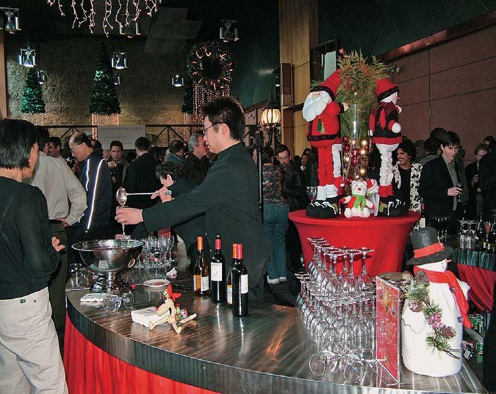
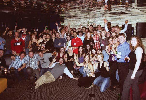
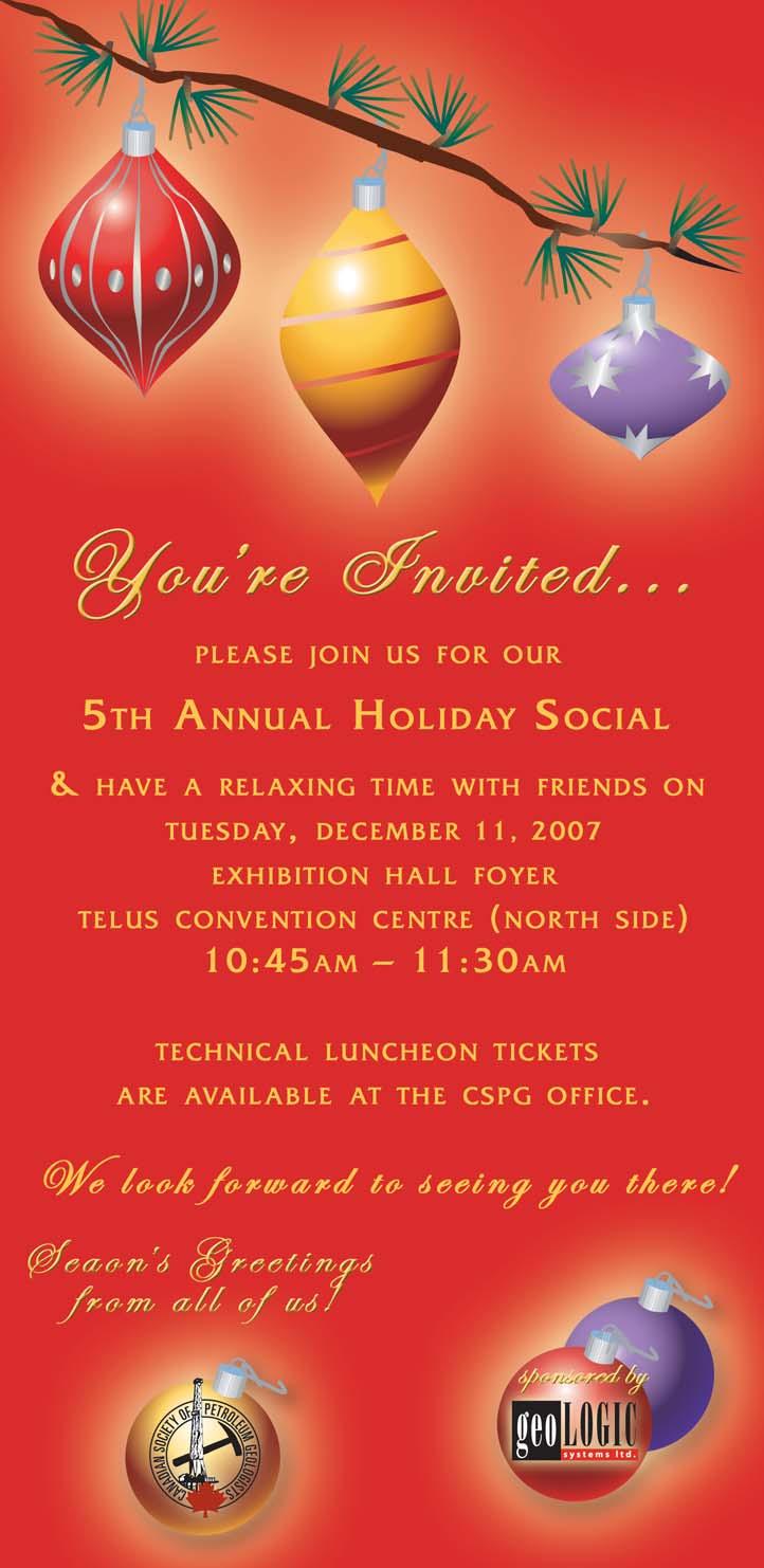
Toast the Holiday Season with us this year at the CSPG’s Annual Holiday Social. Join us for some great food, great speakers and wonderful company. We will also be celebrating the CSPG’s 80th Anniversary, so you won’t want to miss out.
The Holiday Social will be held Tuesday, December 11 at 10:45 am in the Telus Convention Centre, prior to the Technical Luncheon. Last year over 900 tickets were sold, and this year we are limiting ticket numbers to 1,200. Get your tickets soon because you will not want to miss this event.
To download a ticket order form, go to http://www.cspg.org/events/CSPGLuncheon-Tickets.pdf.
We look forward to seeing you there.


SPEAKERS
Ian McIlreath and Thanos Natras EnCana Corporation
11:30 am
Tuesday, December 11, 2007
Telus Convention Centre Calgary, Alberta
Please note:
The cut-off date for ticket sales is 1:00 pm, Thursday, December 6, 2007. Ticket price is $34.00 + GST.
Due to the recent popularity of talks, we strongly suggest purchasing tickets early, as we cannot guarantee seats will be available on the cut-off date.
The petroleum industry is challenged relative to understanding the resource potential of CBM, particularly in Lower Cretaceous Upper Mannville coals. This is due in part to our lack of understanding of the geology of these coal deposits and their nature as reservoir rocks. In general, industry’s understanding of coals is probably at best comparable to a similar understanding we had of clastics and carbonates in the mid1900s.
Since coals differ in many ways from conventional reservoirs, it is inappropriate to apply petroleum system analysis to evaluate CBM from these coals. For the Medicine River and equivalent seams in Central Alberta, we have defined a coal system approach which incorporates data and information on most factors key to understanding the accumulation phase, burial/preservation stage, diagenesis/ coalification, and development of gas resources.
Various previous studies have attributed significant original-gas-in-place numbers for Mannville CBM. The fundamental question is how much of this is recoverable? A key control is the permeability of what essentially is a fractured reservoir rock.
Some effort has been spent by industry to understand the nature of the coal fractures (cleats) and the basic structural framework. Much more effort has been directed to relating present day stress regimes to predict open endogenetic cleat systems. Exogenetic cleating is more poorly understood. There is little documentation on what influence the lateral and vertical variations in both coal quality and character have on cleating and methane generation.
There have been a number of earlier attempts to establish bed thickness and lateral extent of Medicine River equivalent coal seams in Central Alberta. These stratigraphic studies evolved from pure lithostratigraphic correlations to more recent attempts at relatively high resolution sequence stratigraphy in what are non-marine sediments. Coal stratigraphy is very much controlled by accommodation space, which is related to foreland subsidence, and locally to re-activation of faults during deposition. The latter leads to the development of exogenetic cleating. A tecto-stratigraphic approach to correlation establishes a more realistic generic framework from which to interpret the continuity of individual seams and ultimately put depositional information in to a proper context.
To date, there are no depositional models for the Medicine River equivalents in Central Alberta; nor are there any suitable modern analogs. We do, however, have some idea about their depositional environment and their tremendous vertical and lateral variations in composition. We also know that these coals are wet in the up dip east side of the basin and that dry, or dryer, coals exist down dip of the wet coals. With the current data available there are several possible explanations as to the origin of the drier coal fairway.
Ian A. McIlreath (Ph.D., P.Geol., DFGAC)
Ian McIlreath is a Technical Advisor for EnCana Corporation Ltd. Prior to the merger of Alberta Energy Company and PanCanadian Energy to form EnCana, he was Chief Geologist of PanCanadian. Over the last 33 years he has worked in most of the petroleum basins in Canada. He has also worked internationally, primarily in Asia. He has done extensive helicopter-supported fieldwork in mountainous and remote areas of western and northern Canada, mainly on Devonian and Triassic Rocks. More recently he has focused on exploration
and evaluation of Mannville CBM in Central Alberta. Dr. McIlreath’s recent publications have focused on aspects of drilling horizontal wells in coal and on coal quality.
Dr. McIlreath received his Ph.D. from the University of Calgary. He has been President of the Canadian Society of Petroleum Geologists, Geological Association of Canada, and the Canadian Geological Foundation. He has been a Councilor of APEGGA and is APEGGA’s representative to, and a Director of, the Canadian Council of Professional Geoscientists. He is currently Chairman of the newly formed CSPG-CSEG-CWLS Joint Annual Convention Committee. He is a member of SEPM and TSOP. Dr. McIlreath was General Chairman of GeoCanada 2000 and is the acting General Chair of GeoCanada 2010.
Thanos A. Natras (P.Geol.)
Thanos Natras is employed with EnCana Corporation Ltd. where he currently holds the title of Geologist, working mainly the Mannville coals of Central Alberta. He has previously held the role of Operations Geologist with the company since early 2004, where he played an integral part in drilling many successful horizontal wells into Mannville coal seams. Prior to his years at EnCana, Mr. Natras worked as a Wellsite Geologist for eight years on more than 150 wells ranging from 1,000 metres to 4,000 metres, from southeast Saskatchewan to northeast British Columbia. Mr. Natras has co-authored several publications on horizontal drilling in coal, and earlier this year he was awarded Best Geological Poster at the 2007 CSPG/CSEG Annual Convention for his poster entitled, “Successful Wellbore Placement Within a Mannville Coal Seam”.
Mr. Natras received his B.Sc. in Geology from the University of Alberta in 1996. He has been a professional member of APEGGA since 2004 and is a member of the CSPG.
SPEAKER
Dr. Alice V. Payne, C.M., M.SC., LL.D., P.Geol.
11:30 am
Tuesday, January 8, 2008
Telus Convention Centre Calgary, Alberta
Please note:
The cut-off date for ticket sales is 1:00 pm, Thursday, January 3, 2008.
Ticket Price: $34.00 + GST.
Due to the recent popularity of talks, we strongly suggest purchasing tickets early, as we cannot guarantee seats will be available on the cut-off date.
The story of Tom Payne is an adventure book, amazing, heroic, and true. Born to a prominent British physician, the young Tom’s restlessness led him to western Canada in 1912, where he first tackled the farming industry.
After a stint in northern Manitoba, freighting supplies for the developing base metal mines near Flin Flon, he drove a Linn tractor for the ill-fated MacAlpine expedition. This was one of the first attempts at aerial prospecting in the far north, but Tom ended up seal hunting on the ice of Hudson Bay with an Inuit friend. By the early 1930s, he moved to the portage at Fort Smith in northern Alberta where he succumbed to the lure of prospecting, inspired by Labine’s pitchblende discoveries at Great Bear Lake. Grubstaked by his employers, his fi rst efforts at getting rich quickly met with disappointment and near starvation, but he would not give up.
Tom fi nally discovered a rich gold mine among the quartz veins in the shear zones
at Yellowknife; he formed Quin Kola Gold Mines Limited and made an historic mining deal with Cominco. Tom’s four claims became part of the ‘Con’ mine, which was one of Canada’s largest operating gold mines. Instead of retiring later in life, he found new partners and drilled an oil well in Alberta. His story illustrates the heady excitement of frontier exploration, with the persistence and luck required for success.
Expertise in heavy oil & deep basin reservoirs
• AVO / LMR Analysis
• Neural Network Analysis
• PP & PS Registration
• Joint PP & PS Inversion
• Fracture Detection Analysis using Azimuthal AVO
• Spectral Decomposition
Carmen Dumitrescu
P.Geoph., M.Sc., Manager, Reservoir Geophysics
Direct: 403-260-6588 Main: 403-237-7711 www.sensorgeo.com
Alice Payne, P. Geol., obtained her Bachelor of Science and Master of Science degrees from the University of Alberta in the early sixties. She spent fi fteen years as a consultant in the mining industry and academia, and managed Ryan Gold Mines until it was sold in 1990. She worked another fi fteen years in the oil patch, with Gulf Canada Resources, until her retirement in 1995. She is now the president of Arctic Enterprises Limited, her own company. Payne is a member of the Canadian Institute of Mining, Metallurgy and Petroleum; the Geological Association of Canada; the Association of Professional Engineers, Geologists and Geophysicists of Alberta; the American Association of Petroleum Geologists; and was the first woman to be president of the Canadian Society of Petroleum Geologists, in 1992. Payne has served on many boards and volunteer committees, and has been the recipient of several honours and awards, including the Paul Harris Fellowship, the YWCA Women of Distinction Award, a University of Calgary honorary doctorate, and the Order of Canada.
NOTE
Copies of Quin Kola: Tom Payne’s Search for Gold will be available for sale at the January 8, 2008 Technical Luncheon for $25.00 + GST. All proceeds of these sales will go to the CSPG Trust.
Rely on CGGVeritas to maximize your exploration success. Using the most advanced land acquisition technology, we have acquired more data in the Canadian Foothills and Heavy Oil region of N.E. Alberta than any other company, and have achieved an industry-leading QHSES record in the process. When quality and safety are top priorities, choose CGGVeritas.
Focus on Performance. Passion for Innovation. Powered by People. Delivered with Integrity.


SPEAKER
Leslie S. Eliuk, P.Geol. GeoTours Consulting Inc.
12:00 Noon
Friday, November 30th, 2007 Nexen Annex Theatre, +15 level, North of C-Train station, 801-7th Avenue S.W.
The upper Abenaki has two expressions – prograding mixed siliciclastic-carbonate ramps associated with the Sable Island paleodelta and relatively stationary aggrading oolitic carbonate platforms to the southwest and arguably northeast. The unique Deep Panuke gas discovery in the platform margin has unusual, even paradoxical, features that may result from the, possibly unique, regional setting of a large delta dissecting a thick carbonate platform. As well and surprisingly, worldwide the Upper Jurassic has few reefal hydrocarbon fields despite its huge numbers of reefs and carbonate-hosted reserves. Therefore, no Panuke analogues exist.
Paradoxes of a shale plug in the carbonate margin drilled in Dominion J-14, platform drowning, argillaceous buildups, tight oolitic grainstones, sealing ‘reservoir rock’ for down-dip reef stratigraphic traps likely result from the influence of the nearby delta acting on a carbonate margin of complex topography and varied reef types. Prodeltaic fines and nutrients likely are inimical to shallow reef carbonates but favour slowergrowing siliceous sponges. Rapid and deep burial destroys limestone porosity forming lateral seals, and gives top seals plus gasprone source rocks.
Schematic of transition from Sable Island paleodelta southwest to Abenaki carbonate platform. This and some other talk slides can be seen at http://www.offshoreenergyresearch.ca/OETR/NovaScotiaOffshoreBasinForum2007/ tabid/57/Default.aspx
Speculatively, the sediment loading may promote faulting and fracturing pathways for hydrothermal dolomitizing-leaching fluids that are critical to burial reservoir porosity. While Deep Panuke analogues are lacking, the recent discovery of siliceous sponge reefs in the prodelta of the Fraser River, British Columbia comes closest to a rare modern analogue for the Abenaki sponge reef mounds. But those buildups are mainly shale, not carbonate, and also lack effective porosity potential. Fortunately other reefal buildup types can be porous and hydrocarbon-bearing.
This talk reflects the initial attempt at integrating concepts and data. Concepts include the various Jurassic reef endmember types such as given by Reinhold Leinfelder, the three carbonate factories of Wolfgang Schlager, and the various influences of a nearby large delta on carbonates and their organisms. Data include the Nova Scotia offshore example based on previous old and new publications and ongoing well data – especially from cuttings and core – from industry activity, and comparative sedimentology to Baltimore Canyon Trough off the USA. While the study is not completed, I believe it confirms that carbonates and siliciclastics are not a world apart and that paleobiological and paleontological considerations do have economic and not just academic implications.
Les Eliuk is Alberta born. His birth date is January 1, 1946, and he claims to be the first baby boomer. He received his B.Sc. (Hon.GeologyZoology 1968), M.Sc. (Geology-palynology 1969) both at the University of Alberta. He started his 35+ year career in petroleum geology with Shell Canada. From 1969 to1999, he mostly worried about carbonate reservoirs and sour gas. The first six years were spent exploring in Eastern Canada (Quebec Cambro-Ordovician to Gulf of St. Lawrence Carboniferous to offshore Jurassic-Cretaceous carbonate margin). Several publications and even a little gas came from this effort but more of both resulted during subsequent years in the Western Canada Sedimentary Basin and Foothills.
As far back as 1970 Eliuk and Nova Scotia were linked, when he spent a seasick summer on a gas-sniffer boat. Later he helped drill the first reefs on the buried carbonate margin in 1974 and published 90 pages on the Abenaki in 1978. His fascination continued so, when pensioned off in 1999, he has been happy to help some smart younger PanCanadian/EnCana geologists with their Deep Panuke discovery as GeoTours Consulting.
He continues his Mesozoic reef interest and carbonate research with a move in mid-2005 to Lunenburg and the start of a Ph.D. programme at Dalhousie University in 2006. If you want to talk reefs, he can be contacted at geotours@ eastlink.ca.


Railroad Valley and adjacent related structures, Nevada: analogues and clues from the Flathead Valley, southeastern British Columbia, Canada
SPEAKER
Peter Jones
Wedge Energy Inc., Calgary peter.jones@thementors.com
12:00 Noon
Thursday, December 6, 2007 Petro-Canada
West Tower, room 17B/C (17th floor) 150 6 Ave SW Calgary, Alberta
For more than twenty years, Railroad Valley, Nevada was the site of some of the most prolific onshore oil wells in the U. S. A. Two neighbouring wells in Railroad Valley produced over 21 million barrels of oil, but ongoing exploration is severely restricted by lack and complexity of subsurface and surface data and uncertain structural relationships.
Comparable structural relationships occur in a simpler setting in the Flathead Valley, British Columbia, a half-graben in the Rocky Mountains, formed by the post-Laramide Flathead extensional fault. Paralleling the fault for more than 150 kilometres southeastward into northwest Montana, the Tertiary Kishenehn Basin occupies the half graben, containing up to 3,300 metres of
Reservoir Imaging
Expertise in heavy oil & deep basin reservoirs
• Time Lapse (4D) Processing
• 4D Cross Equalization
• Multicomponent (3C, 4C) Processing
• 3D Merging
• PSTM with Common Offset Vector Binning
Hart Janssen
B.Sc., Manager, Seismic Processing
Direct: 403-260-3372 Main: 403-237-7711
www.sensorgeo.com
Paleogene fine-grained lacustrine deposits and valley fill, overlying an irregular surface of Paleozoic carbonates and younger rocks. Fill includes reservoir-scale slide blocks of Proterozoic, Paleozoic, and Mesozoic carbonates and clastics, and oil seeps.
In the Flathead region, the Jurassic Fernie shale is a major detachment horizon separating overlying structures above from those below it, a function similar to that of the Mississippian Chainman shale of Nevada. Both units involve huge and anomalous thickness variations. The Flathead Valley has the potential for discoveries comparable to those in Nevada, without the structural complexity that has hampered Railroad Valley exploration. The comparison can benefit exploration in both areas.
Dr. Peter Jones obtained his D.Sc. in Geology from Colorado School of Mines and has focused on oil and gas exploration of structurally complex zones around the world. In 1982 he showed that the “triangle zone” at the east margin of the Canadian Cordillera was no local anomaly, but a common and logical element of fold and thrust belts that would be recognized worldwide. More significantly, the resultant revision of structural interpretations that followed resulted in new oil discoveries in an unknown number of countries, but acknowledged in the USSR, where in 1998 he was made a member of the Russian Academy of Natural Sciences in recognition of his contribution to their understanding of structural geology and the resultant oil and gas discoveries. Also, in 1998 he was awarded the Douglas medal of the Canadian Society of Petroleum Geologists, for “having contributed enormously to our understanding and evolution of deformed belts in general and the Canadian Rocky Mountain fold and thrust belt in particular.” In 2003 he was made an Honorary Professor of Geology at The China University of Geosciences in Beijing.
Talks are free and do not require pre-registration. Please bring your lunch. Refreshments are provided by HEF Petrophysical Consulting, and the room is provided by Petro-Canada. If you would like to be on the Structural Division e-mail list, or if you’d like to give a talk, please contact Jamie Jamison at (403) 269-3158 or jamie@ hef.com.
7:30-9:30 PM
Friday, December 14, 2007 Mount Royal College, Room B108
Calling all members with an interest in palaeontology: our December 14 session will consist of a potluck dinner at 7:30 pm sharp, which will be followed by a palaeontology slide show contest with prizes for the winners.
The contest categories are:
• Prepared specimens
• Fossils in the field
• Scenic shots
• Paleo-humour
• Deadline December 10, 2007 (last day for receipt of pictures)
• Entries will be limited to 10 per member, so be selective.
• Submitted files should be in jpeg, gif, or tiff format, and can be emailed to Philip. Benham@shell.com
• If you don’t have prints in digital format, I can scan them for projection onto the screen. Please mail prints to: Philip Benham Shell Canada Ltd PO Box 100, Stn M 400-4 Ave SW, Calgary, AB, T1Y 3P7
• Each photo should be documented with:
– Your name (Photographer must be an APS or CSPG member or attend Mount Royal College)
– Contest category
– Slide title
– Photo location (if relevant)
– Geological information (if possible)
As each slide comes up the contributor may stand and give a brief comment on their photo with the understanding that the paleo-
DIVISION PROFILE
The Heavy Oil / Oil Sands Division was created in November 2007 to provide a forum for CSPG members who are interested in learning more about both the technology and geological reservoirs associated with the Western Canada Basin. In addition, this forum will provide the
opportunity for you and your peers to network, and share thoughts and ideas on this particular discipline.
Our meetings will be on the last Thursday of every month at 8:00 am, and there will be a complimentary continental breakfast supplied. The breakfast session will start at 8:00 am and finish by 9:00 am. Initially, depending on size, the event will be hosted by RPS Energy at 1400 - 800 5 Avenue SW,
humour may take slightly longer to set the stage. Attendance is not required to enter pictures or to win.
The APS requests the privilege of using the winning entries to generate a fundraising product (such as a calendar). We are also looking for volunteers for a panel of “celebrity judges.” Please contact Philip Benham if you are interested.
Pop and juice will be provided during the potluck portion of the event. Please bring finger food of your choice. Any questions regarding the contest can be directed to Philip Benham by phone or email (see below).
INFORMATION
This event is jointly presented by the Alberta Palaeontological Society, Mount Royal College and the CSPG Palaeontology Division. For details or to present a talk in the future please contact CSPG Palaeontology Division Chair Philip Benham at 403-691-3343 or programs@albertapaleo. org. Visit the APS website for confirmation of event times and upcoming speakers: http://www. albertapaleo.org/
sponsored by

Calgary. There will be no cost associated with this event, and anyone may attend. Each month a different service company will sponsor the continental breakfast. The first Division Talk will be Thursday, January 31, 2008.
For more information on this Division, please contact the Division Chair, Nicole Keilly, RPS Energy at keillyn@rpsgroup. com or call (403) 263-0449.
Robert A. Meneley (P. Eng., P. Geol.) has been appointed Chairman of the Business Committee, responsible for the planning, execution, quality control and delivery of the next report scheduled for release in 2010. Mr. Meneley brings more than 50 years of domestic and international exploration experience and was the Committee’s Chief Analyst for the previous assessments reports by the CGPC in 1997 and 2001, and was the Technical Advisor for the 2005 Report. Although the Committee is dominantly a volunteer group of geoscientists, to provide direct assistance to Mr. Meneley in the preparation and production of the 2010 Report, Peter M. Milburn has been contracted as Report Coordinator. Mr. Milburn brings his extensive computer hardware and software experience, graphics and report design skills to the CGPC. Gerry DeSorcy (P.Eng.), former Chairman of the Business Committee, continues as Chairman of the Board of Directors and heads the Committee’s Finance Sub-Committee. Prior to joining the CGPC in 2003 Mr. DeSorcy was the Chairman of the Alberta Energy and Utilities Board.
For information on the Committee, its activities or to volunteer to assist in the next report contact the office at (403) 297-7222, e-mail cdngaspotential@shaw.ca or visit our website www.canadiangaspotential. com. Opportunities are available in the assessment teams for the WCSB, frontier basins, and unconventional gas sources in Canada.
A limited number of the Committee’s 2001 Report is now available at no charge. This report, which originally sold for $500 CDN, is in a seven ring binder, contains over 500 pages and provides gas resource assessments and maps for exploration plays in the WCSB and Canadian frontier basins, and discussions on potential in-situ CBM resources. To arrange pickup of this valuable report at the Committee’s office in the EUB’s Energy Resources Building contact the Committee’s office by phone or e-mail as shown above.
FIELD TRIPS
Nova Scotia (Pre-Meeting)
• Permian to Jurassic Rift Successions
• Classic Carboniferous Sections
• Onshore Cretaceous Reservoir Equivalents
Morocco (Post-Meeting)
• Triassic Synrift Reservoir Facies & Architecture
Portugal (Post-Meeting)
• Jurassic Carbonates & Fluvio-deltaic Successions
ABSTRACT SUBMISSION DEADLINE
March 1,2008
All abstracts must by submitted through the conference website
EXTENDED ABSTRACT DEADLINE
May 1,2008
Extended abstracts for accepted papers must be submitted by this date
WEBSITE www.conjugatemargins.com
COURSES
Practical Salt Tectonics
Petroleum Systems Modelling
CORE WORKSHOP
Offshore Nova Scotia Reservoirs, Facies & Sequences
SEISMIC DATA ROOM
Latest Central Atlantic Programs & Profiles
PROGRAM INFORMATION
David E.Brown dbrown@cnsopb.ns.ca
Grant D.Wach grant.wach@dal.ca
LOGISTICAL INFORMATION
Trudy D.Lewis trudy.lewis@ns.sympatico.ca
| by Heather Tyminski
“Get involved and help create a better geoscience industry for your children, for your province, and for your country.”
ANTHONY AJ CADRIN, CO-CHAIR OF THE JOINT ANNUAL CONVENTION COMMITTEE
Employer: Sword Energy Inc.
Position: Vice-President Geosciences
Number of Years as a CSPG Volunteer: 15 years
What are your responsibilities as Co-Chair of the Joint Annual Convention Committee?
The goal of the committee is to create a three-year plan of the joint annual conventions with our partner societies (CSEG and CWLS). Along with my fellow committee members, I am responsible for organizing and arranging the Co-Chair and Technical Chair candidates to run the CSPG CSEG CWLS annual conventions. This involves the identification of the theme and the building of the management teams. It’s like being the movie director and picking your actors.
What other volunteer positions have you held in the past at the CSPG?
I’ve volunteered on the Student Industry Field Trip (SIFT) Committee (1992-1996) and the CSPG Executive (Service Director in 1998-1999 and Programs Director in 2001).
I’ve been the Technical Advisor and Special Session Chair for the Annual Convention (1998), the CSPG representative to the Geoscience Professional Development Centre (2000), Chair of the Technical Luncheon Committee (2002-2007), Link Award Committee (2002-2007), and CoChair for the Joint Annual Convention Committee (2005-Present).
Being on the executive takes a lot of time – a minimum of 300 hours a year, and to do a good job, it’s 500 hours. If you can commit to this, you’ll be pleased with your results and will be able to accomplish your personal directive goals. Each CSPG committee member sets their personal directive goals for them to achieve in the two years they are on committee.
As the Technical Luncheon Chair, I designed, developed, and implemented the Webcasting program, which has been one of the CSPG programs that most fulfills the technical content and outreach goals. We get thousands of people viewing these Technical Luncheon Webcasts (see the CSPG website to view the Technical Luncheon Webcasts).
Why did you initially decide to volunteer?
I wanted to give back to the geological community in which I was gainfully employed. When I was in university, one of my professors (Dr. Hugh Hendry, now deceased) talked about the CSPG and how it was the geological society you would want to be a member of as a student and in your subsequent working career. When I was finally in Calgary I read in the Reservoir an ad to volunteer for SIFT. I thought what an opportunity – I can assist in educating and provide students with an opportunity to join the industry and, in doing so, find the best people to join the industry. The more people I could get to join, the more great people I would have to work with.
After all these years, why do you continue to volunteer for the CSPG? First of all, I got to work with some of my industry co-workers in the CSPG outside
of work. I got to know them better, which improved our work relationships. Secondly, it got me exposed to people I may not have met through industry activities. It enabled me to learn more about the people in my vocation. Thirdly, the accomplishments realized in volunteering with the CSPG, provided me with the benefit of good group dynamic skills, which encouraged me to seek the same sense of accomplishment and effective team building in my job. Lastly, in volunteering you can pick who you work with. Most people who volunteer have similar values and join because they want to work together with like-minded people, thus creating a very positive and productive environment.
What are some memorable moments you have had as a volunteer?
I’ve had many memorable moments: SIFT students and the field trips, working with the CSPG Executive and CSPG staff, the Past Presidents’ Dinner, and Pearls of Wisdom Dinner (many valuable lessons imparted to me by very experienced industry people), sold-out Technical Luncheons, the success of the Webcast Program, being involved in the creative process for the Gussow Conferences and Joint Annual Conventions. I was also honoured to receive the Tracks Award in 2004. To me it meant that everything I was doing was appreciated, and that my peers enjoyed working with me.
Could you offer some words of wisdom to our CSPG members?
Through volunteering, I have met and made lifelong colleagues and friends. Get involved and help create a better geoscience industry for your children (if they follow in your footsteps), for your province, and for your country. The people I have met have been the biggest reward and together we accomplished lasting legacies for CSPG membership.
What is your opinion of current volunteerism in the CSPG?
The CSPG members who I have met through the volunteer program have made a significant impact to my professional and personal life, and it has been my privilege to share time and efforts with them. I strongly recommend to CSPG members to get involved with the CSPG as a volunteer and experience the rewards and accomplishments with us.
| by Lisa Dean, Fekete Associates Inc.
You have been asked to:
• Evaluate the properties that are for sale in a data room.
• Determine whether to participate in a prospect.
• Calculate the potential reserves encountered by a discovery well.
• Identify the upside potential in a mature field.
In all these situations, the bottom line is “how much oil or gas exists and can be produced, and what will be the return on investment?” This article addresses this question.
Volumetric estimation is the only means available to assess hydrocarbons in place prior to acquiring sufficient pressure and production information to apply material balance techniques. Recoverable hydrocarbons are estimated from the inplace estimates and a recovery factor that is estimated from analogue pool performance and/or simulation studies.
Therefore, volumetric methods are primarily used to evaluate the in-place hydrocarbons in new, non-producing wells and pools and new petroleum basins. But even after pressure and production data exists, volumetric estimates provide a valuable check on the estimates derived from material balance and decline analysis methods (to be discussed in upcoming Reservoir issues).
Volumetric estimation is also known as the “geologist’s method” as it is based on cores, analysis of wireline logs, and geological maps. Knowledge of the depositional environment, the structural complexities, the trapping mechanism, and any fluid interaction is required to:
• Estimate the volume of subsurface rock that contains hydrocarbons. The volume is calculated from the thickness of the rock containing oil or gas and the areal extent of the accumulation (Figure 1).
• Determine a weighted average effective porosity (See Figure 2).
• Obtain a reasonable water resistivity value and calculate water saturation.
With these reservoir rock properties and utilizing the hydrocarbon fluid properties,
oil-in-place or
gas-in-place volumes can be calculated.
For OIL RESERVOIRS the original oil-inplace (OOIP) volumetric calculation is:
Metric:
OOIP (m3 ) =
Rock Volume * * (1- S w ) * 1/B o
Where: Rock Volume (m3 ) = 10 4 * A * h
A = Drainage area, hectares (1 ha = 10 4m2 )
h = Net pay thickness, metres = Porosity, fraction of rock volume available to store fluids
S
B
w = Volume fraction of porosity filled with interstitial water
o = Formation volume factor (m3 /m3 ) (dimensionless factor for the change in oil volume between reservoir conditions and standard conditions at surface)
1/B o = Shrinkage (Stock Tank m3 /reservoir m3) = volume change that the oil undergoes when brought to the earth’s surface due to solution gas evolving out of the oil.
Imperial:
OOIP (STB) =
Rock Volume * 7,758 * * (1- S w ) * 1/B o
Where: Rock Volume (acre feet) = A * h
A = Drainage area, acres
h = Net pay thickness, feet
7,758 = API Bbl per acre-feet (converts acre-feet to stock tank barrels) = Porosity, fraction of rock volume available to store fluids
S w = Volume fraction of porosity filled with interstitial water
B o = Formation volume factor (Reservoir Bbl/STB)
1/B o = Shrinkage (STB/reservoir Bbl)
To calculate recoverable oil volumes the OOIP must be multiplied by the Recovery Factor (fraction). The recovery factor is one of the most important, yet the most difficult variable to estimate. Fluid properties such as formation volume factor, viscosity, density, and solution gas/oil ratio all influence the recovery factor. In addition, it is also a function of the reservoir drive mechanism and the interaction between reservoir rock and the fluids in the reservoir. Some industry standard oil recovery factor ranges for various natural drive mechanisms are listed below:
PETREL* SEISMIC-TO-SIMULATION SOFTWARE AMPLIFIES THE IMPACT OF E&P TEAMS. Optimize reservoir performance with a single solution. Unite the subsurface domains of geophysics, geology, and reservoir engineering to evaluate reservoir quality away from well control while honoring geologic features that impact reservoir performance.
“Being able to run multiple simulations with multiple scenarios really helped bracket the uncertainty, especially with limited well control in the deepwater environment. Faster, more accurate answers with a greater range of uncertainties can be covered in a very short time.” SubsurfaceLead,MurphyOil
Schlumberger Information Solutions—reducing risk for better business results.
www.slb.com/petrel
(Continued on
For GAS RESERVOIRS the original gasin-place (OGIP) volumetric calculation is:
Metric:
OGIP (103m3 ) =
Rock Volume * * (1-S W ) * (Ts * Pi ) (Ps * Tf * Zi )
Where: Rock Volume (m3 ) = 10 4 * A * h
A = Drainage area, hectares (1 ha = 10 4m2 )
h = Net pay thickness, metres = Porosity, fraction of rock volume available to store fluids
S w = Volume fraction of porosity filled with interstitial water
Ts = Base temperature, standard conditions, °Kelvin (273° + 15°C)
Ps = Base pressure, standard conditions, (101.35 kPaa)
Tf = Formation temperature, °Kelvin (273° + °C at formation depth)
Pi = Initial Reservoir pressure, kPaa
Zi = Compressibility at Pi and Tf
Imperial:
OGIP (MMCF) =
Rock Volume * 43,560 * * (1-S w ) * (Ts * Pi )
(Ps * Tf * Z )
Where: Rock Volume (acre feet) = A * h
A = Drainage area, acres (1 acre = 43,560 sq. ft)
h = Net pay thickness, feet = Porosity, fraction of rock volume available to store fluids
Sw = Volume fraction of porosity filled with interstitial water
Ts = Base temperature, standard conditions, °Rankine (460° + 60°F)
Ps = Base pressure, standard conditions, 14.65 psia
Tf = Formation temperature, °Rankine (460° + °F at formation depth)
Pi = Initial Reservoir pressure, psia
Zi = Compressibility at Pi and Tf
To calculate recoverable gas volumes , the OGIP is multiplied by a recovery factor. Volumetric depletion of a gas reservoir with reasonable permeability at conventional depths in a conventional area will usually recover 70 to 90% of the gas-in-place. However, a reservoir’s recovery factor can be significantly reduced by factors such as: low permeability, low production rate, overpressure, soft sediment compaction, fines migration, excessive formation depth, water influx, water coning and/or behind pipe cross flow, and the position and number of producing wells. As an example, a 60% recovery factor might be appropriate for a
gas accumulation overlying a strong aquifer with near perfect pressure support.
* h)
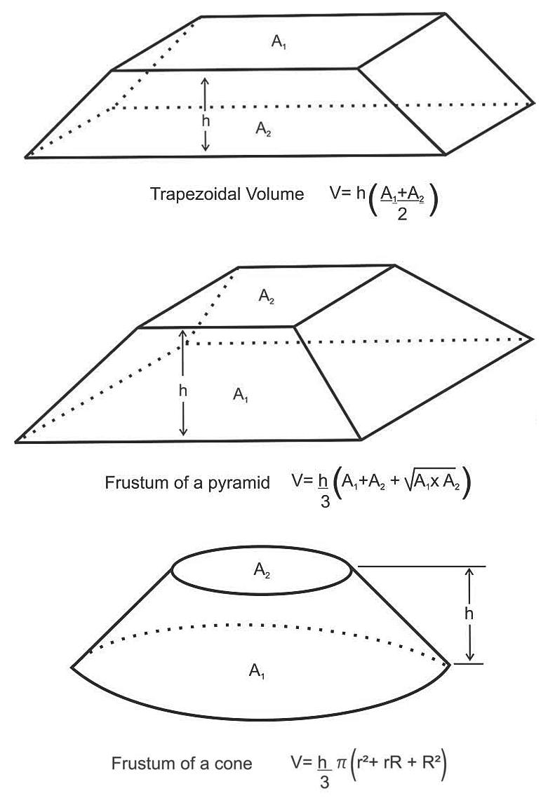
Reservoir volumes can be calculated from net pay isopach maps by planimetering to obtain rock volume (A * h). To calculate volumes it is necessary to find the areas between isopach contours. Planimetering can be performed by hand or computer generated. Given the areas between contours, volumes can be computed using; Trapezoidal rule, Pyramidal rule, and/or the Peak rule for calculating volumes (see Figure 3).
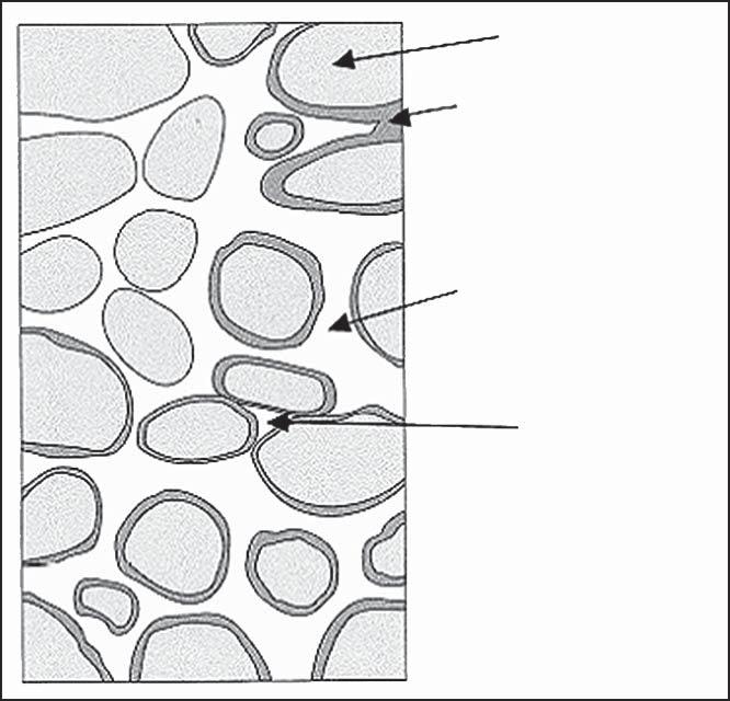
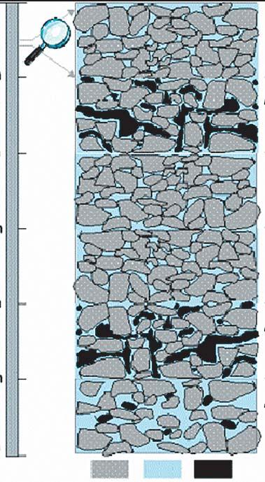
Net pay is the part of a reservoir from which hydrocarbons can be produced at economic rates, given a specific production method. The distinction between gross and net pay is made by applying cut-off values in the petrophysical analysis (Figure 4). Net pay cut-offs are used to identify values below which the reservoir is effectively non-productive.
In general, the cut-off values are determined based on the relationship between porosity, permeability, and water saturation from core data and capillary pressure data. If core
low porosity, low permeability, very low or no oil saturation, non-reservoir
high porosity, high permeability, high oil saturation, gross and net reservoir
low porosity, low permeability, very low or no oil saturation, gross reservoir
low porosity, low permeability, very low or no oil saturation, gross reservoir
high porosity, high permeability, high oil saturation, gross and net reservoir
high porosity, high permeability, high water saturation, gross and net reservoir
Gross thickness = A+B+C+D+E+F = 6 m
Gross reservoir = B+C+D+E+F = 5 m
Gross pay = B+C+D+E = 4 m
Net thickness = Net reservoir = B+E+F = 3 m
Net pay = B+E = 2 m
is unavailable, estimation of a cut-off can be derived from offset well information and comparative log signatures.
Porosity values are assigned as an average over a zone (single well pool) or as a weighted average value over the entire pay interval using all wells in a pool. Similarly, the average thickness-weighted water saturation using all wells in the pool is commonly assumed as the pool average water saturation.
Drainage area assignments to wells should be similar to offset analogous pools depending on the geological similarities and productivity of the wells within the analog. Pressure information is useful in estimating pool boundaries and if any potential barriers exist between wells. Seismic analysis usually improves the reservoir model and provides for more reliability in reserve or resource estimates.
The volumetric calculation uses the initial oil or gas formation volume factor at the initial
non-pay
gross pay and net pay
gross pay
gross pay
gross pay and net pay non-pay
data is obtained and performance type methods such as material balance and decline analysis can be utilized. Finally, integrating all the techniques provides more reliable answers than relying solely on any one method.
Aprilia, A.W., Li, Z., McVay, D.A. & Lee, W.J., SPE Gas Tech Symposium May 15-17 2006, Calgary. SPE Paper 100575-MS
Canadian Institute of Mining, Metallurgy and Petroleum, Determination of Oil and Gas Reserves, Petroleum Society Monograph Number 1, 1994.
SPEE and CIM, Canadian Oil and Gas Evaluation Handbook, Vol 2. Detailed Guidelines for Estimation and Classification of Oil and Gas Resources and Reserves, November 2005.
Look for our next article on “Decline Analysis” in the January issue of the Reservoir.
This article was contributed by Fekete Associates, Inc. For more information, contact Lisa Dean at Fekete Associates, Inc.
reservoir pressure and temperature. Both B o and B g are functions of fluid composition, reservoir pressure and temperature and consequently of reservoir depth. The B o and B g values from analogous offset pools are often used as an initial estimate for the prospect under consideration.
A volumetric estimate provides a static measure of oil or gas in place. The accuracy of the estimate depends on the amount of data available, which is very limited in the early stages of exploration and increases as wells are drilled and the pool is developed. Article 8, entitled Monte Carlo Analysis, will present a methodology to quantify the uncertainty in the volumetric estimate based on assessing the uncertainty in input parameters such as:
• Gross rock volume – reservoir geometry and trapping
• Pore volume and permeability distribution
• Fluid contacts
The accuracy of the reserve or resource estimates also increases once production


Houston, TX
February 11-15, 2008
Courses will include:
Thinking on Your Feet—Making Effective Business Presentations
Creativity Petroleum Exploration
Secrets of Career Success as a Professional Petroleum Geologist
Risk, Uncertainty and Decision-Making in Unconventional Resource Plays
Introduction to Coalbed Methane
Assessment of Unconventional Shale Resources Using Geochemistry
Geologic Interpretation of Seismic Data
Seismic Amplitude Interpretation—Lithology and Pore Fluid Estimation
Seismic Geomorphology & Seismic Stratigraphy
Seismic Stratigraphy & Seismic Geomorphology
Basic Openhole Log Interpretation
Formation Evaluation of Thinly-Bedded Reservoirs
Quick Guide to Carbonate Well Log Analysis
HOSTED BY THE NORRIS CONFERENCE CENTER 9999 RICHMOND AVE., SUITE 102 HOUSTON, TX 77042
713-780-9300; FAX: 713-780-9490
SPECIAL AAPG GROUP RATES AT NEARBY HOTELS!
Tuition for the week is only $1395 for AAPG Members, $1495 for non-members* or $350/day for individual courses *(price increases to $1495/$1595 after 1/14/08)
REGISTRATION AND INFORMATION: Toll-free (U.S. and Canada) 888-338-3387, or 918-560-2650
Fax: 918-560-2678; e-mail: educate@aapg.org
Download a registration form at http://www.aapg.org/education/wec.cfm
The Western Inter-University Geoscience Conference (WIUGC) is a student-run conference that is held at a different western Canadian university every year. This year it is being hosted by the University of Alberta in Edmonton on January 3-6, 2008. It is a place where undergraduate and graduate students can present their research, learn about job opportunities in the industry, and meet other geology and geophysics students from across western Canada. The universities that are invited are the University of British Columbia, the University of Victoria, the University of Calgary, the University of Lethbridge, the University of Saskatchewan, the University of Regina, the University of Winnipeg, Brandon University, and Lakehead University.
This year, we are expecting 150-200 people for the conference. It will be held at the Shaw Conference Centre in Edmonton, in conjunction with the Courtyard by Marriott Hotel. There are a variety of fun activities throughout the three days of the conference.
On Thursday, January 3, everyone will arrive and settle into their hotel rooms. After dinner, there will be an informal welcome to WIUGC and networking events into the evening of the first night.
On Friday, the first full day of the conference, there will be talks given by undergraduate and graduate students from across western Canada, as well as posters, which will be judged by a combination of U of A faculty and industry people, with prizes given to the best posters and talks. A guest speaker will present at an informal lunch for those interested in attending. There will also be an industry fair to help students learn about career opportunities across Canada in the oil and gas industry, as well as the mining industry. This is a day for networking and getting to meet the delegates and industry people from around the country.
On Saturday, day trips are being organized around Edmonton that will enable the delegates and representatives from the industry to observe local geology and the industry in Alberta. A banquet on the final night will allow students, industry representatives, faculty and guests to listen to a keynote speaker, and a final opportunity to network and visit with students and industry representatives from across western Canada. All who attend
will hopefully leave with an appreciation of the geology and industry of Alberta, a heightened awareness of what is happening in the geosciences of other western Canada provinces, and a great experience in learning and in meeting other students. Relationships built at WIUGC will last long after our university careers are over.
Anyone interested in attending or participating in WIUGC Edmonton 2008, or
simply would like more information about the conference can contact Becky Schmidt at wiugc2008@gmail.com or at our mailing address, which is:
WIUGC 2008 c/o P.S. Warren Geological Society Dept. of EAS 1-26 ESB, University of Alberta Edmonton, AB T6G 2E3
Jim Aitken was a long-time member of our society who set high standards in his profession and achieved excellence in his many interests: the outdoors, skiing, climbing, hunting, construction, and especially field geology.
Born in Scarborough, Ontario, his first connection with the Geological Survey of Canada (GSC) was as a student assistant in geological field parties. Jim was especially inspired by working with John Wheeler, the eminent mapping geologist renowned for his work in rugged mountainous terrain. Following his bachelor’s degree in geological engineering at the University of British Columbia (1950), Jim’s doctoral studies were at the University of California, Los Angeles (1950-1953), where there began a long friendship with Tom Oliver, who later became the Dean of Science at the University of Calgary. The field component of his studies was the complex terrain of the Atlin area of northwestern British Columbia and was supported by the GSC (GSC Memoir 307, 1959). Following a stint in South America with International Petroleum, he arrived in Calgary in 1959, initially with J. C. Sproule and Associates, then, from 1960, with the GSC’s Calgary office, where he was prominent in major mapping operations in northern Canada and in the Rocky Mountains of Alberta and British Columbia. His eminent scientific work at the Survey (with leadership roles as Head of the Paleozoic Stratigraphy Section, 1966-1969 and Head of the fieldwork components of Operation Norman, 1968 and 1969) included three years (19691972) as a Professor at the University
of Calgary where he taught stratigraphic concepts to undergraduate and graduate students with emphasis on the importance of careful scientific observations and where he inspired students with the fascination of his field experiences.
Jim’s scientific work produced many elegant geological maps and comprehensive papers. Focussing on the Cambrian and Ordovician rocks of the southern Rocky Mountains, he revised and elucidated the stratigraphy and depositional environments of the Lower and Middle Ordovician (1967 with Brian Norford), of the Upper Cambrian (1967 with Bob Greggs) and especially the Middle Cambrian, for which GSC Bulletin 398 (1997) is an outstanding synthesis of the very complex depositional environments of the outboard regions of a tropical carbonate platform. Among his innovative concepts was the recognition and explanation of a series of Grand Cycles of transgressions and regresssions reflecting changes in sealevel (1966, 1978). Also his recognition of the Kicking Horse Rim as a recurrent feature effecting the facies changes in Middle Cambrian time (1971). Another important contribution was his initiation of the now widely used term cryptalgal to describe stromatolite-like sediments that lack any apparent microstructure (1967). Jim described the stratigraphic framework for the Burgess Shale Project led by Harry Whittington of Cambridge University and, with Don Stott, compiled and edited the comprehensive GSC synthesis volume on the sedimentary cover of the Canadian craton (1993). Structurally, using his intimate knowledge of the Lower Paleozoic stratigraphy within the individual thrust plates, he outlined restoration of the depositional locations of the plates, contributing to the understanding of crustal shortening within the southern Rocky Mountains (1988). In the northern mainland and the adjacent Victoria Island, he described the stratigraphy and interpreted the depositional environments of the Proterozoic rocks, including recognition of Late Proterozoic glaciations.
A natural athlete, Jim Aitken enjoyed 25 years on the Lake Louise Ski Patrol. For the succession of his student field assistants, their first few days were spent learning demanding mountaineering techniques together with emergency procedures for anything that might happen in the mountains. A classic result was that once, during the
awesome quiet of an auto-rotating descent on the failure of a helicopter’s engine, the field assistant sitting behind Jim tapped him on the shoulder and asked AJim, is this when we all put on our gloves ? @. Hunting, primarily birds, was a speciality of Jim, often with colleagues Cecile, Cook, Hughes, McIlreath, Norford, or Thorsteinsson and his superbly trained Labrador Retrievers, preferably golden. An excellent shot, Jim’s shout of AYours ! @ meant that someone else had a single second to shoot before Jim downed the prime pheasant. Construction was another hobby, including the building of a large cottage near Sundre and both a home and a guest cottage on Denman Island. Watchdog and vigilante for the English Language was a continuing role, whether with regard to the scientific writing of his colleagues or the oral transgressions of CBC commentators.
An early tragedy saw Jim and Anne losing their young son in an accident while working in South America. Their other children Tenley, Scott, and Sally and the grandchildren were a constant pride for Jim. His second wife Roxanna shared the challenges of construction near Sundre and on Denman and their energetic and creative retirement as Island People.
Jim’s scientific honours included our Society’s Douglas Medal (1987) for outstanding contributions in sedimentary geology. He led many field trips for the Society and served as a Director on the Society’s Executive in 1969. His contributions to the North American Commission on Stratigraphic Nomenclature from 1975 to 1978 (Chairman 1978), led to the publication of the extensively revised North American Stratigraphic Code in 1983.
Jim Aitken enjoyed life to the full and valued his friends and colleagues. He found many friends in all of his disparate activities, each of whom recognized his strong personality and his dedication to excellence in whatever he was doing. One of the superb Canadian geologists of his generation, Jim Aitken’s sophisticated geological maps and his elegant syntheses of Lower Paleozoic rocks have set high standards for earth scientists in Western Canada.
Brian Norford
Selected Items from Jim Aitken’s extensive bibliography.
1959 Atlin Map-area, British Columbia (104N). GSC Memoir 307, 87 pp.
1966 Middle Cambrian to Middle Ordovician cyclic sedimentation, southern Rocky Mountains of Alberta. Bulletin of Canadian Petroleum Geology, 14, p. 405-441.
1967 Classification and environmental significance of cryptalgal limestones and dolomites, with illustrations from the Cambrian and Ordovician of southwestern Alberta. Journal of Sedimentary Petrology v. 37, p. 11631178.
1967 Upper Cambrian formations, southern Rocky Mountains of Alberta, an interim report. GSC Paper 66-49 (with R. G. Greggs), 91 pp.
1967 Lower Ordovician Survey Peak and Outram formations, southern Rocky Mountains of Alberta. Bulletin of Canadian Petroleum Geology, v. 15, p. 150-207 (with B. S. Norford).
1971 Control of Lower Paleozoic sedimentary facies by the Kicking Horse Rim, southern Rocky Mountains, Canada. Bulletin of Canadian Petroleum Geology, v. 19, p 557-569.
1972 Cambrian and Ordovician biostratigraphy of the southern Rocky Mountains. Guidebook XXIV International Geological Congress Excursion A19 (with W. H. Fritz and B. S. Norford), 57 pp.
1978 Revised models for depositional Grand Cycles. Bulletin of Canadian Petroleum Geology, v. 26, p. 515-542.
1981 Stratigraphy and sedimentology of Upper Proterozoic Little Dal Group, Mackenzie Mountains. GSC Paper 8110, p. 47-71
1988 Palinspastic map of southern Canadian Rocky Mountains. GSC Open File 1696.
1989 Uppermost Proterozoic formations, central Mackenzie Mountains, Northwest Territories. GSC Bulletin 368, 25 pp.
1991 Ice Brook Formation and late Proterozoic glaciation. GSC Bulletin 404, 43 pp.
1993 Sedimentary cover of the craton in Canada. GSC, Geology of Canada (7th Edition) , No. 5 (with D. F. Stott), 826 pp.
1997 Stratigraphy of the Middle Cambrian platformal succession, southern Rocky Mountains. GSC Bulletin 398, 322 pp.

Wellsite Consultants & Geology Consultants
Owners Gary McLean & Erskine Wigmore appreciate the continued support from our friends and clients over the
3
and invite new clients to use our stable of well trained and supervised geologists. Off: 403-281-5779
Fax: 403-398-1328 grmclean@telus.net


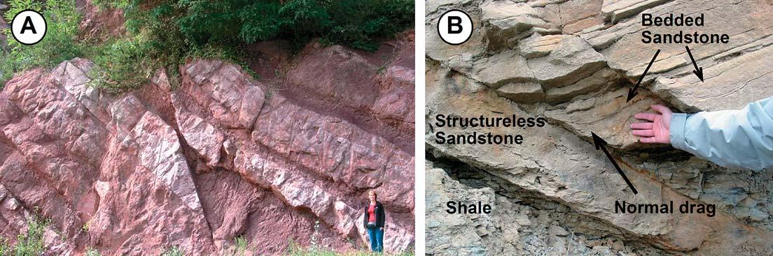
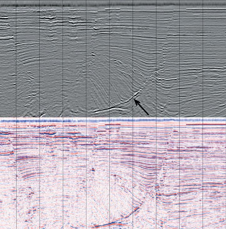
Figure 3. Seismic transect from the Gulf of Mexico showing faults using two different colour bars. Faults are defined by reflection terminations and offsets, changes in dip or amplitude, and (arrow) a fault-plane reflection. Note the differences in fault definition between the greyscale display and the blue-white-red display. A greyscale image is preferred for fault interpretations. Data courtesy of PGS.
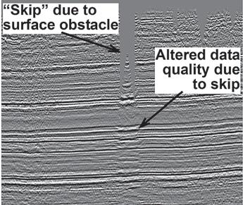
Figure 4. A data “skip”, a result of a surface obstacle preventing shotpoints and receivers from being located in this area, in this image is responsible for changes in seismic character in a zone below the skip. The margins of this zone might be misinterpreted as faults, especially if the interpreter was not looking at the upper part of the data.
(...Continued from page 33)
It may be difficult to pick faults if the data are too noisy, or if the fault blocks lack continuous reflections that can be used to identify an offset. Both of these latter problems are common in shallow parts of seismic data from the Rocky Mountain
Foothills, where Upper Cretaceous and Tertiary non-marine strata (which tend to lack lateral reflection continuity) are thrusted and data quality is poor because of low stacking fold and steep structural dips.
Like outcrop analogues, it is important to recognize that seismic data will not always show transects that are parallel to structural dip – the best orientation for observing the displacement. We typically try to collect 2D seismic lines that are parallel to structural dip. However, logistical or other problems (e.g., we may be forced to collect the data along existing roads) may prevent us from doing so. Furthermore, there may be faults, minor or major, that are at an angle to the dominant structural fabric. For any of these reasons, 2D seismic data may prevent us from seeing the true fault geometries.
Three-dimensional seismic data are a significant improvement over 2D data because they allow the interpreter to view the data from any angle. To best interpret faults, we need to view and pick them on dip-oriented transects through the seismic data cube. It is, however, instructive to take the time to view faults from different directions in the 3D seismic data. We quickly learn that the fault geometries we see in a seismic transect vary, depending on the orientation of that transect with respect to the orientation of the fault. For example, Figure 5 is a strike section through a listric normal fault. An unwary interpreter (perhaps working with 2D seismic data) might observe stratal terminations that appear to onlap a truncation surface, and conclude that an unconformity is present. However, views perpendicular to that shown in Figure 5 (i.e., dip lines) show that we are indeed looking at a listric normal fault. This exercise will help us to recognize different interpretation possibilities when working with 2D seismic data or even outcrop exposures.
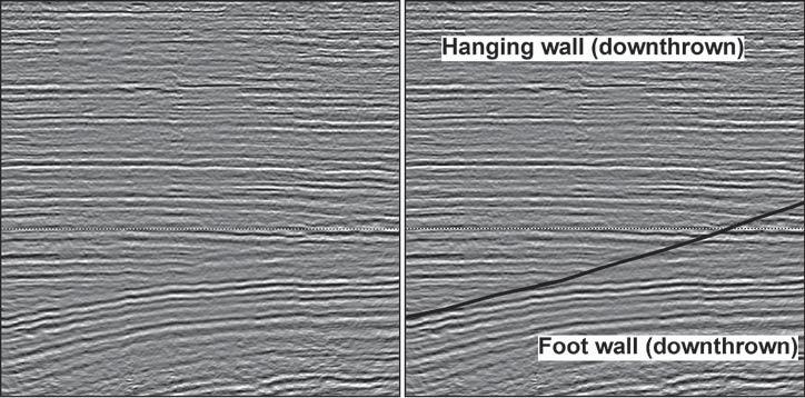
5. Uninterpreted and interpreted strike-oriented seismic transects through a listric normal fault. The transect has been selected from a 3-D seismic volume, and so its orientation with respect to the faulting is known. Displacement of the hanging wall is directly towards the viewer, but the sense of movement cannot be determined from this view. The angular discordance between reflections and reflection terminations associated with the fault is sometimes misinterpreted as an unconformity by participants in my seismic interpretation classes.
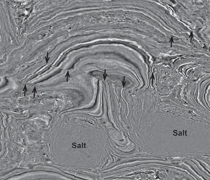
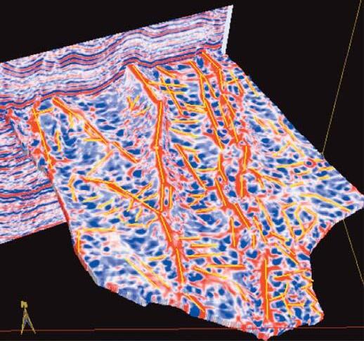
Figure 6. Timeslice through a 3-D
data volume from the Gulf of Mexico. Some reflection terminations are indicated by arrows, and can be used to define the traces of faults. The circular reflection-free zones are salt bodies. Data courtesy of PGS.
When working with 3D seismic data, it is important to be able to recognize the appearance of faults on timeslices (or depth slices, if the data have been depth converted) through the data cube. Figure 6 shows a timeslice through a 3D seismic volume from the Gulf of Mexico. Faults can be recognized by curvilinear features marked by reflection terminations, lateral offsets of reflections, or angular discordances between reflections on either side of the fault. Faults that are oriented parallel to the strike of the bedding will, however, be difficult to see in timeslices.
In the mid-1990s, geophysicists working at Amoco described a way to process 3D seismic cubes to produce a “coherency” attribute that would facilitate fault mapping. Since then, other processing and software companies have developed similar attributes that go by different names (e.g., “semblance”1) but, simplistically, they are measures of the lateral variability in trace shape. Portions of the data where reflections are continuous have high coherency, whereas abrupt changes in reflection shape, such reflection offsets associated with faults, have low coherency.
1For simplicity, I will use the term “coherency” to refer to these processing products, even though there are differences in the way the attributes are derived mathematically.
The three images shown in Figure 7 should help to demonstrate the usefulness of these attributes. In the top image, we see a timeslice through a 3D seismic cube from the Western Desert of Egypt. After some inspection, it might be possible to recognize curvilinear trends (reflection truncations, changes in amplitude, etc.) running from upper left (NW) to lower right (SE). The middle image shows exactly the same timeslice, but this time through a version of the data that has been processed to show coherency. Discontinuities, i.e., areas of low coherency, are shown in black, and it is clear that this attribute is clearly delineating the location of the NW-SE striking faults. The reader should compare the number of faults visible in the coherency display with the number that might be interpreted in the amplitude timeslice of the amplitude version at top. It is clear that we will be able to better map the faults using a coherency timeslice than an amplitude version of the same data. Finally, some software packages allow two different versions of a seismic data cube to be viewed together, a technique known as co-rendering. The lowest image of Figure 7 shows the amplitude and coherency timeslices co-rendered. This type of display very clearly defines the faults by allowing us to view the coherency lineations and reflection offsets at the same time.
Some faults may be associated with only minor amounts of displacement. In these cases discrete reflection terminations or offsets may not be visible in the seismic data. Instead, the faults may be associated with minor displacements that are seen as slight “inflections” along a seismic reflection. The upper portion of the antithetic fault in Figure 3 shows displacements of this nature. In these cases, faults may be detected using “horizon attributes” that measure the dip,
(Continued on page 36...)
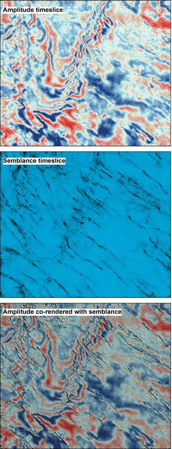
Figure 7. Timeslices through a 3-D seismic volume from the Western Desert of Egypt. Faults are visible in the amplitude timeslice (top) as reflection offsets and truncations that trend from upper left to lower right. The faults are much easier to identify in the semblance (“coherency”) timeslice (middle) from the same level. Blue areas represent continuous reflections and black areas indicate changes in reflection continuity (e.g., faults). The image at bottom shows semblance and amplitude displayed together (“co-rendered”). This display is most useful for interpreting/mapping faults. Data courtesy of Apache (Cairo).
azimuth, curvature, or some other aspect of a surface that has been picked in a 3D seismic volume.
Figure 8 shows (top) a time-structure map of a Cretaceous sandstone at a Rocky Mountain uplift. Gaps in the surface are “fault-heave polygons” that show the locations and orientations of normal faults. The faults were identified and mapped using vertical transects and timeslices through amplitude and coherency versions of the seismic data. The middle map of Figure 8 shows the dip attribute, a measure of how steeply the surface is dipping at every trace location in the 3D survey, derived from the same surface (the surface had been interpolated across the fault polygons prior to the dip calculations). The steeply dipping areas indicate the locations of faults. Although the same fault patterns seen in the timestructure map are apparent at first glance, closer inspection reveals differences. For example, some structures originally mapped as a single fault are probably two separate but linked faults. Furthermore, some fault tips can be extended – the dip attribute identifies small offsets of the horizon that could not be identified visually. The lowest map shows the azimuth attribute, a measure of which way the surface is pointing, has been derived. A colour bar has been selected to highlight surfaces that are dipping in different directions. The main NW-SE striking faults are visible in the center of the dataset, but in this image some subtle NW-SE striking folds are apparent in the upper part of the survey area. These folds were not apparent in either the original time-structure map or the dip map. Clearly, the horizon attributes are helping us to detect small-scale features that are not readily apparent when undertaking a conventional interpretation of the data.
Horizon curvature is another approach for detecting small-scale structures. Furthermore, by tracking reflections in three dimensions, it is possible to derive curvature volumes from 3D seismic data. The curvature volumes can be viewed and analyzed like coherency volumes to detect faults. For brevity however, these methods will not be described in detail here.
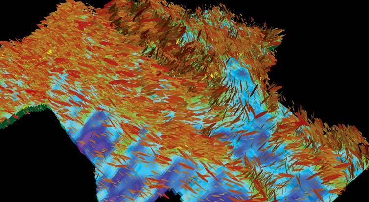
Other types of displays can be useful for identifying and mapping small-offset faults. For example, Figure 9 shows amplitudes draped over a rendered surface (blue – high amplitude, red – low amplitude) that is illuminated from the northeast (upper right). The linear amplitude trends and shadows highlight some northwest-southeast striking faults.
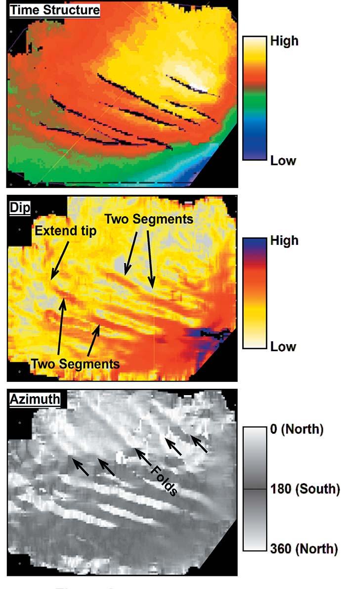
Figure 8. Time-structure map (top) of a Cretaceous horizon from a Rocky Mountain uplift mapped using amplitude and coherency vertical transects and timeslices through a 3-D seismic volume. The black areas are “fault-heave polygons” that show the locations and orientations of normal faults that offset the horizon. The dip map (middle) derived from the horizon shows the faults as relatively steeply dipping areas (red) that offset nearly horizontal bedding (yellow, white). Some of the changes to the fault interpretation (e.g., breaking apparently continuous faults into segments, extending fault tips) are highlighted. At bottom the azimuth map shows which way (compass orientation) the surface is pointing. The colour bar has been chosen to display north-facing areas in white and south-facing areas in grey, as if a flashlight is being shone on the surface. The NW-SE striking faults are visible, but harder to interpret than in the dip view. On the other hand, some NW-SE striking folds are visible in the upper part of this display but are not readily apparent in the dip or time-structure maps.

Figure 9. Amplitude map of an Upper Cretaceous horizon affected by shallow thrusts in the Deep Basin. The surface is being illuminated from the northeast (upper right), highlighting northwest-southeast striking structures. The combination of low amplitudes (red) and shadows indicates the location and orientation of faults. Data courtesy of Millenium Seismic.
This article has examined several different techniques for identifying faults in seismic data. From the above discussion, it should be apparent that it will be easier to identify and map faults using 3D seismic data instead of 2D data. Three-dimensional seismic data allow the user to view the data from any angle, and identify the direction in which the faults are most apparent (usually a dip-oriented section). Coherence volumes may be derived from 3D seismic data, and these datasets can greatly facilitate the identification of faults. Finally, horizon attributes derived from surfaces mapped in 3D volumes can be useful for identifying small-offset faults that could not be identified using 2D seismic data. Not fully discussed or illustrated here, but of significant importance, is the impact of acquisition and processing parameters in defining the appearance of faults in the seismic data.

Scan, print, digitize, interpret and manage data with...
NeuraScanner
NeuraMap - NEW!
NeuraLaser
NeuraSection
NeuraLog
NeuraDB - NEW!
| by Ruth Klinkhammer
Presenters at the 2007 Gussow Conference agreed that while there are significant oil and gas resources in the Arctic, there are also many challenges and obstacles slowing exploration and development.
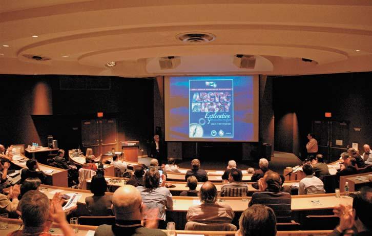
The two-day conference at the Banff Centre in October 2007 saw over 25 experts present on a variety of issues ranging from northern pipeline development, to terrestrial and underwater reserves, to Arctic sovereignty, to the potential impacts of climate change on exploration and development. The wide range of topics, only a fraction of which are discussed below, reflected the changing state of the Arctic, and the challenges facing the north.
Conference Co-Chair Benoit Beauchamp, Executive Director of the Arctic Institute of North America at the University of Calgary, opened the meeting by pointing out the heightened media awareness of the north. “You cannot open a newspaper or turn on the television without seeing one or two or three stories on the Arctic,” said Beauchamp. This increased interest is a reflection of the massive changes taking place in the north.
Other speakers focused on oil and gas deposits in the north and agreed that there are significant resources of conventional and unconventional gas and oil. Of particular note, Dennis Johnston, manager of Devon Canada’s Frontier/New Exploration Group,
announced Devon’s successful application for a Significant Discovery License for the offshore discovery of 250 MMB of oil at the Paktoa well in the Beaufort Sea. Johnston encouraged other companies to become active in the north and said technological improvements are opening new frontiers
for exploration. “There’s real potential up north,” he said.
As well as the Beaufort Sea, speakers also concentrated on Alaska’s north slope, the Yukon, the Sverdrup Basin, and the Mackenzie corridor region. Ashton Embry, from the Geological Survey of Canada, told the group that there are many areas in the Sverdrup Basin with rocks and structures that could capture and contain oil or gas. “The Sverdrup Basin has the potential to become a major petroleum-producing basin.”
Embry’s data show the basin contains eight kilometres of Mesozoic to Paleogene strata, and it is the Mesozoic succession which he believes holds the greatest potential for future discoveries. Already 18 oil and gas fields have been discovered in the Triassic and Jurassic strata with recoverable reserves estimated at 18 TCF of gas and 500 MM bbls of oil. “It will all come to be when the price of oil is right,” predicted Embry.
The Mackenzie Valley and the proposed pipeline were addressed by a number of speakers. Conference Co-Chair Gerry


Reduce your drilling costs and benchmark your drilling performance with detailed information from our growing database of over 150,000 Canadian and US wells. Divestco offers you instant online access to North America’s largest repository of drilling data including tour sheets, drilling curves and customizable reports. Call Jay Bell at 403.219.7253 or email jay.bell@divestco.com for more information.

| by Ian Young
My name is Ian Young and I am the current President of the Canadian Federation of Earth Scientists (Fédération canadienne des sciences de la Terre), a new name for the now 35-year-old Canadian Geoscience Council. The CGC was founded to provide a united voice for earth sciences in Canada at a time when there was galvanizing concern over the lack of influence of earth science on the national stage, a lack of awareness of the impact and benefit of earth science among the general population, and concern over the recruiting of bright young students with little high school exposure to earth science into earth science programs at Canadian Universities.
Thirty-five years later, not only does the original mandate still ring true, but in fact with earth science-related topics such as climate change, geohazards and energy supply ever more in the news, it is even more relevant today than it was in the 1970s. Unfortunately, while there were

many excellent initiatives that came out of CGC and some tireless and energetic earth scientists contributing countless hours to the cause, CGC never developed into the influential national voice that was envisaged.
Recognizing this, two individuals in different parts of the country and different parts of the earth science community, initiated a path of renewal that included the presidents of Canada’s major earth science organizations. A remarkable consensus of opinion across all segments of earth science developed over the next two years, culminating in a meeting in November 2006 in Quebec City.
At the Quebec meeting, 20 unanimous motions were passed, including the name change to CFES-FCST, and a presidency that will rotate through the various sectors of earth science, starting with Oil and Gas. This is how I found myself in the possession

of a compelling request from a group of oil and gas organizations late last summer to head up a rejuvenated organization.
As a manager and leader in the oil and gas business, my own petroleum geology had slipped into the background, and I had come to think of myself more as an oil and gas businessman than a geologist. In the months since, after countless phone calls, visits to Whitehorse, Yellowknife, Vancouver, Ottawa, Toronto, and Quebec City, and meeting a fascinating crosssection of committed and passionate earth scientists, not only have I rediscovered these original roots, but I have become more familiar with the whole earth science community that stretches across every part of this country, a community with profound reach and accomplishment.
I have become aware, for example, that in 2006 more money was raised in Toronto for the global mining business than New York, London, or any other world market; I have learned the annual PDAC conference is the largest mining-related conference in the world; and I have learned about an NRCan initiative whereby Canadian earth scientists work with local geoscientists in Peru, Bolivia, Ecuador and Colombia to help local residents protect themselves from the risks associated with volcanoes, earthquakes, and landslides.


With Canada’s vast geological landscape and abundance of natural resources it will come as no surprise that Canadian earth science is held in high regard. Indeed, in a study conducted by the Council of Canadian Academies (CCA) of the quality and reputation of science in Canada, earth science was ranked highly in every category. It is the only science that covers the spectrum from extraction of resources through to the understanding of groundwater and the impact of surfacial processes on the physical environment.
As earth scientists, we are privileged to understand both the benefits of the earth’s riches and the physical, monetary, and environmental costs of their extraction while in addition, dealing with remote and often inconclusive data gives us a balanced understanding of risk and uncertainty. With this broad perspective we are in a unique
position to provide meaningful input on many concerns that trouble modern day policy makers and public opinion. It is this milieu in which earth sciences and CFES finds itself today, and the milieu in which we must build our vision.
The CFES vision involves defragmenting the earth science community in Canada, effectively recruiting bright young minds and improving the visibility, awareness, and influence of earth science nationally. This is a tall task facing CFES, but I am optimistic. Any organization that can combine the expertise of physical geographers, hydrogeologists, natural hazard specialists, and mining, oil and gas geoscientists, has incredible potential energy to harness.
What gives me additional optimism is the strength of the organizations that form the make-up of CFES and their obvious willingness, even eagerness, to collaborate. Colin Yeo, the current President of the CSPG, one of the largest earth science organizations in Canada, listed collaboration with and involvement in CFES as one of his four priorities in the coming year.
With this kind of support in mind, my vision for CFES is more along the lines of LINUX, the open source program. Where other software companies compete aggressively for talent and market share, LINUX provides a service that is made powerful by collaboration across the broad community of experts who contribute time and energy to provide a world-class system.
Similarly I see CFES as an entity made immeasurably stronger by the diversity and brain power of a broad population, in this case earth scientists. Continuing on the analogy, CFES will be successful through the success of its member organizations and, with an emphasis on collaboration, leveraging the work and volunteer effort that is already in place, rather than creating a large organization that competes for funding and volunteer effort with those organizations.
A number of initiatives designed to provide useful service to member societies are currently underway. They are the following:
• Maintain a comprehensive website with links to all member organizations and relevant Earth science related societies. (www.geoscience.ca or www.cfes-fcst. ca);
• Develop a comprehensive earth sciences conference calendar (already posted on the website);
• Create a “Careers in Earth Science” website targeting junior high school children through CGEN (the Canadian Geoscience Education Network);
• Continue work to investigate shared service potential for member societies, including insurance, registration, student chapters, and communications;
• Complete a new “highly qualified personnel” survey to provide a snapshot of employment opportunities in the
spectrum of earth science sectors, as well as highlight the expected demographicrelated shortfall;
• And partner with the Canadian National Committee for the International Year of Planet Earth, coming up in 2008. As part of that initiative, CFES is the organizational partner for the exciting new book project: Four Billion Years and Counting, Canada’s Geological Heritage planned for publication during 2008.
(Continued on page 46...)
The Department of Earth and Planetary Sciences at McGill University invites applications for a tenure-track position in Sedimentary Geology at the level of Assistant Professor. Applicants with interdisciplinary research interests, including but not limited to paleoenvironments, basin analysis, and sedimentology, are particularly encouraged to apply. The appointee will establish an externally funded research program, mentor graduate students, and teach undergraduate and graduate courses in their field.
A Ph.D. is required at the time of appointment and post-doctoral experience is desirable. Salary will be commensurate with experience and standing in the community. Applicants should submit a letter of application, curriculum vitae, statement of research interests and teaching philosophy, and three confidential letters of recommendation sent under separate cover by the candidate’s referees upon the request of the candidate. Applications should be sent to: Professor John Stix, Chair, Department of Earth and Planetary Sciences, McGill University, 3450 University Street, Montreal, Quebec H3A 2A7, Canada. The anticipated start date for the position is July 1st, 2008.
Review of the applications will begin on December 15th, 2007 and continue until the position is filled. Information about the department can be found at http://www.eps.mcgill.ca.
McGill University is committed to equity in employment and diversity. It welcomes applications from indigenous peoples, visible minorities, ethnic minorities, persons with disabilities, women, persons of minority sexual orientations and gender identities and others who may contribute to further diversification. All qualified applicants are encouraged to apply; however, in accordance with Canadian immigration requirements, priority will be given to Canadian citizens and permanent residents of Canada.


Now there is a better method for identifying gas and measuring gas saturation in cased holes. Baker Atlas is proud to introduce the GasViewSM service, a high-resolution measurementand analysis service that produces an exceptionally clear picture of reservoir gas.
Using Baker Atlas’ RPMSM pulsed neutron system, the GasView service can be used to measure reservoir gas in virtually any well. Applications range from identifying by-passed pay in wells nearing abandonment to openhole log replacement for new wells.
Contact your Baker Atlas representative today to learn how the GasView service can help you produce more gas with greater efficiency.