Please submit RESERVOIR articles to the CSPG office.Submission deadline is the 23rd day of the month,two months prior to issue date. (e.g.,January 23 for the March issue).
To publish an article,the CSPG requires digital copies of the document.Text should be in Microsoft Word format and illustrations should be in TIFF format at 300 dpi.For additional information on manuscript preparation,refer to the Guidelines for Authors published in the CSPG Bulletin or contact the editor.
COORDINATING EDITOR & OPERATIONS
Jaimè Croft Larsen
CSPG
Tel:403-264-5610,Ext 227 Fax:403-264-5898
Email:jaime.croftlarsen@cspg.org
TECHNICAL EDITOR
Ben McKenzie
Tarheel Exploration
Tel:403-277-4496
Email:bjmck@telusplanet.net
ADVERTISING
Kim MacLean
Corporate Relations,CSPG
Tel:403-264-5610,Ext 229
Email:kim.maclean@cspg.org
Advertising inquiries should be directed to Kim MacLean.The deadline to reserve advertising space is the 23rd day of the month, two months prior to issue date.All advertising artwork should be sent directly to Kim MacLean.
The RESERVOIR is published 11 times per year by the Canadian Society of Petroleum Geologists. This includes a combined issue for the months of July/August.
Advertisements,as well as inserts,mailed with the publication are paid advertisements.No endorsement or sponsorship by the Canadian Society of Petroleum Geologists is implied.
The CSPG Rock Shop is an attractive and affordable way to target the CSPG readership. Spaces are sold at business card sizes (3.5” wide by 2” high).To reserve space or for more information,please contact Kim MacLean at 403-264-5610,ext.205.
The contents of this publication may not be reproduced either in part or in full without the consent of the publisher.
DEPARTMENTS
FRONT COVER
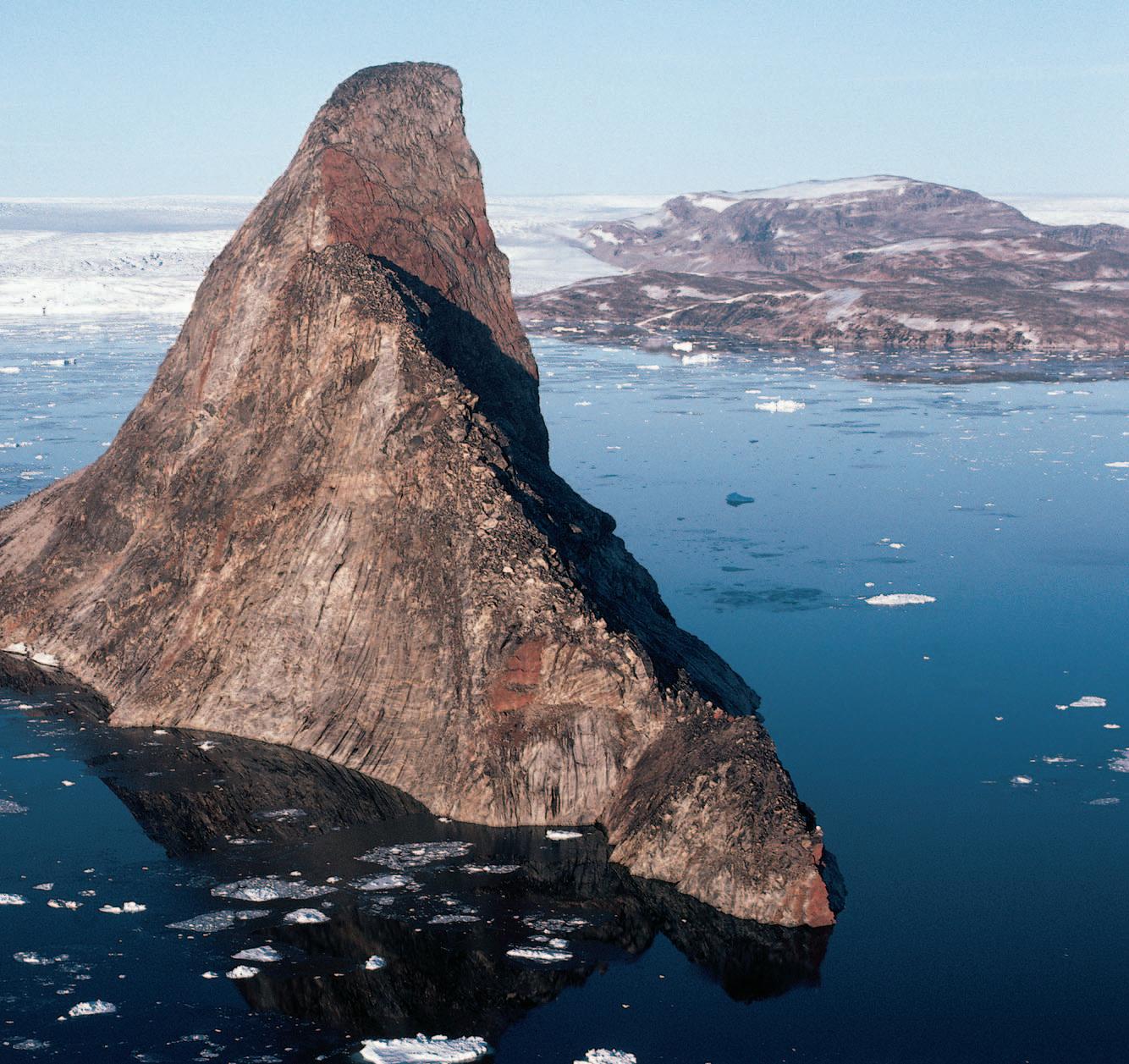
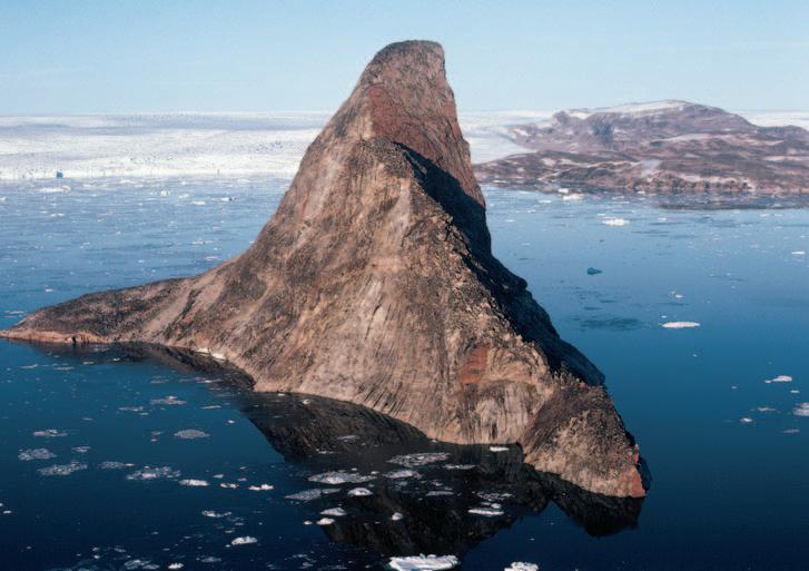
Precambrian Shield, northwest Greenland. Melville Monument, a 330 m-high monolith of Archean gneiss in Melville Bay. Photo by Thomas Frisch.
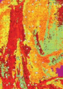
» Extensive High Resolution Airborne Magnetic (HRAM) databases covering much of the WCSB
» Large gravity databases over the Alberta and British Columbia Foothills, Mackenzie Delta, and Colville Hills regions of the NWT
» Low cost, reliable data, adding value to your play at key points in the complete exploration cycle; Gain regional perspectives on fairways or high grade specific prospects for seismic acquision or drilling
» Learn more about how your basement affects your play. Visit www.gedco.com and browse our publications to find Peirce and Griffith, 2004, “Keep an eye on your basement. It is the foundation of the overlying stratigraphy and structure.”
Given our overall profit of $271,000,it is easy to see the importance of these programs to the fiscal wellbeing of the Society.
SERVICES
It gives me great pleasure to report that the CSPG is in a very strong fiscal position at it's yearend of August 31,2006.This is a direct result of the CSPG's diversified programs and services,our creative and enthusiastic volunteer base,and our dedicated and talented office staff.
Our yearend net income was $271,000 on revenues of $1.993 MM against expenses of $1.722 MM.This operating surplus for 20052006 is over 3 times higher than our budgeted surplus of $85,000.This surplus is the largely the result of better than expected performance from our Programs and Communications portfolios which offset higher than anticipated deficits in Services,Outreach and Operations.
The Society's Programs and Services continue to drive our revenue stream and fund our important outreach initiatives and technical publications.As we all know,the success our industry is enjoying does come with higher operating expenses and your Executive is working diligently with our office staff to meet these challenges.Our Society is fortunate to be backstopped by a robust investment portfolio that can provide flexibility in the future should it ever be required.
PROGRAMS
The CSPG's Programs portfolio is led by Memory Marshall,Doug Hamilton,and Nadya Sandy.Programs such as our Annual Convention,Continuing Education,and Technical Luncheons generate the majority of the CSPG's revenue.The 2006 convention was an overwhelming success,generating $518,000 in profit,including $54,000 received from the AAPG for the 2005 Convention and booked in the current fiscal year.Other programs,such as Continuing Education and the Technical Luncheon contributed profits of $65,000 and $22,000 respectively.Overall,our Programs portfolio generated $633,000 in profit for the CSPG.
Our Services portfolio is led by Shannon Nelson Evers and David Newman.Services are comprised of Membership and our Awards and Social Programs.Membership dues contributed $310,000 in profit in 2005-2006.Our Social programs essentially broke even resulting in a small loss of approximately $1,000.When Awards expenses of $10,000 are taken into consideration,overall,Services provided $299,000 in profit in 2005 - 2006. Obviously,our membership is critical to the health of the Society.CSPG membership has stayed flat for the past few years and our challenge will be to keep our membership vibrant and involved with the Society in light of the demographics facing our industry.
COMMUNICATIONS
The Communications portfolio is led by Ashton Embry.Communications oversees the Reservoir,Bulletin,Geological Calendar,Electronic Communications at www.cspg.org.,and Public Affairs. Communications essentially broke even in 2005-2006;recording a small loss of $3,000.Revenues from the Reservoir were very strong once again in 2005-2006 at $224,000.These revenues offset expenses for both the Reservoir and the Bulletin. Revenues from royalties from AAPG Datapages and GeoScienceWorld offset expenses for electronic communications and public affairs,overall resulting in the approximately breakeven position for Communications.
OUTREACH
Outreach is led by David Middleton.This important portfolio consists of the annual Honourary Address,the Student Industry Field Trip – which exposes our industry to students from every university in Canada, the Visiting Lecture Program,University Awards,and University Outreach.Outreach ran at a deficit of $103,000 in 2005-2006. It should also be noted that expenses for Outreach are partly offset by the CSPG Trust that transferred $64,000 in corporate directed-donations to Outreach during the fiscal year.
Have you signed up yet???
4th Annual AAPG WINTER EDUCATION CONFERENCE
Houston, TX
February 12-16, 2007
Courses will include:
Essentials of Subsurface Mapping
Introduction to Computer Mapping
Practical Mapping of Surfaces, Properties and Volumes for Reservoir Characterization
Rock Properties of Tight Gas Sandstones
Introduction to Coalbed Methane
Risk, Uncertainty and Decision-Making in Unconventional Resource Plays
Seismic Amplitude Interpretation—Lithology and Pore Fluid Estimation
3D Seismic Attributes for Prospect Identification and Reservoir Characterization*
Seismic Geomorphology & Seismic Stratigraphy
Basic Openhole Log Interpretation
Advancements in Petrophysics and What to do with Them
Introduction to DST’s for Geologists
HOSTED BY THE HILTON HOUSTON WESTCHASE HOTEL 9999 WESTHEIMER ROAD
713-974-1000
FAX: 713-974-6866
SPECIAL AAPG GROUP RATES!
*borrowed with permission from SEG
Tuition for the week is only $1295 for AAPG Members, $1395 for non-members* or $325/day for individual courses
*(price increases to $1395/$1495 after 1/15/07)
REGISTRATION AND INFORMATION: Toll-free (U.S. and Canada) 888-338-3387, or 918-560-2650
Fax: 918-560-2678; e-mail: educate@aapg.org
Download a registration form at http://www.aapg.org/education/wec.cfm
THE CSPG GRATEFULLY ACKNOWLEDGES ITS CORPORATE MEMBERS:
THE CSPG GRATEFULLY ACKNOWLEDGES ITS CORPORATE MEMBERS:
ABU DHABI OIL CO., LTD. (JAPAN)
APACHE CANADA LTD.
BAKER ATLAS
BG CANADA EXPLORATION & PRODUCTION, INC.
BP CANADA ENERGY COMPANY
BURLINGTON RESOURCES CANADA LTD.
CANADIAN FOREST OIL LTD.
CANETIC RESOURCES TRUST
CONOCOPHILLIPS CANADA
CORE LABORATORIES CANADA LTD.
DEVON CANADA CORPORATION
DOMINION EXPLORATION CANADA LTD.
DUVERNAY OIL CORP.
ENERPLUS RESOURCES FUND
geoLOGICsystems ltd.
GRIZZLY RESOURCES LTD.
HUNT OIL COMPANY OF CANADA, INC.
HUSKY ENERGY INC.
IHS
IMPERIAL OIL RESOURCES LIMITED
LARIO OIL & GAS COMPANY
MJ SYSTEMS
MURPHY OIL COMPANY LTD.
NCE RESOURCES GROUP INC.
NEXEN INC.
NORTHROCK RESOURCES LTD.
PENN WEST PETROLEUM LTD.
PETRO-CANADA OIL AND GAS
PETROCRAFT PRODUCTS LTD.
PRIMEWEST ENERGY TRUST
PROVIDENT ENERGY LTD.
RPS ENERGY
SHELL CANADA LIMITED
SPROULE ASSOCIATES LIMITED
SUNCOR ENERGY INC.
TALISMAN ENERGY INC.
TOTAL E&P CANADA LIMITED
WEATHERFORD CANADA
CORPORATE MEMBERS AS OF OCTOBER 24, 2006
IHS + PETRA®…
depthsinnovationsresults visions that exceed all others. now.
CONTOURING
Faultedcontours
Isopachs
Volumetrics
Gridoperations
Newflexingoptions
CROSS SECTIONS
NewUnassignedTops
Digitaland/orRaster
Geocolumnshading
Stratigraphic/Structural
Shadebetweencrossover
Dipmeterdata
MAPPING OPTIONS
ExpandedGISFunctions
Bubblemaps
Productioncharts
Logcurves
Posteddata
HighlightedSymbols
3D VISUALIZATION
Deviatedwellbores
Digitallogs
Gridsurfaces
Tops,ShowsandPerfs
Landgridoverlay
Mapimages
DECLINE CURVES
ComputeEUR,RR,etc.
Hyperbolicorexp.
Rate/TimeorCumP/Z
UserdefinedEcon.Limit
User defined Extrap.Time
How our vision supports yours
PETRA: Pioneer of easy, affordable PC solutions for today’s workflows.
IHS: The industry’s leading choice of E&P data and delivery systems to populate PETRA projects. The combination: Fast, confident prospect analysis for you.
Download a trial version at www.ihs.com/energy/petra, or call us at 888-738-7265 for more information. And stay tuned for more on our vision of streamlined data flows for prospect studies.
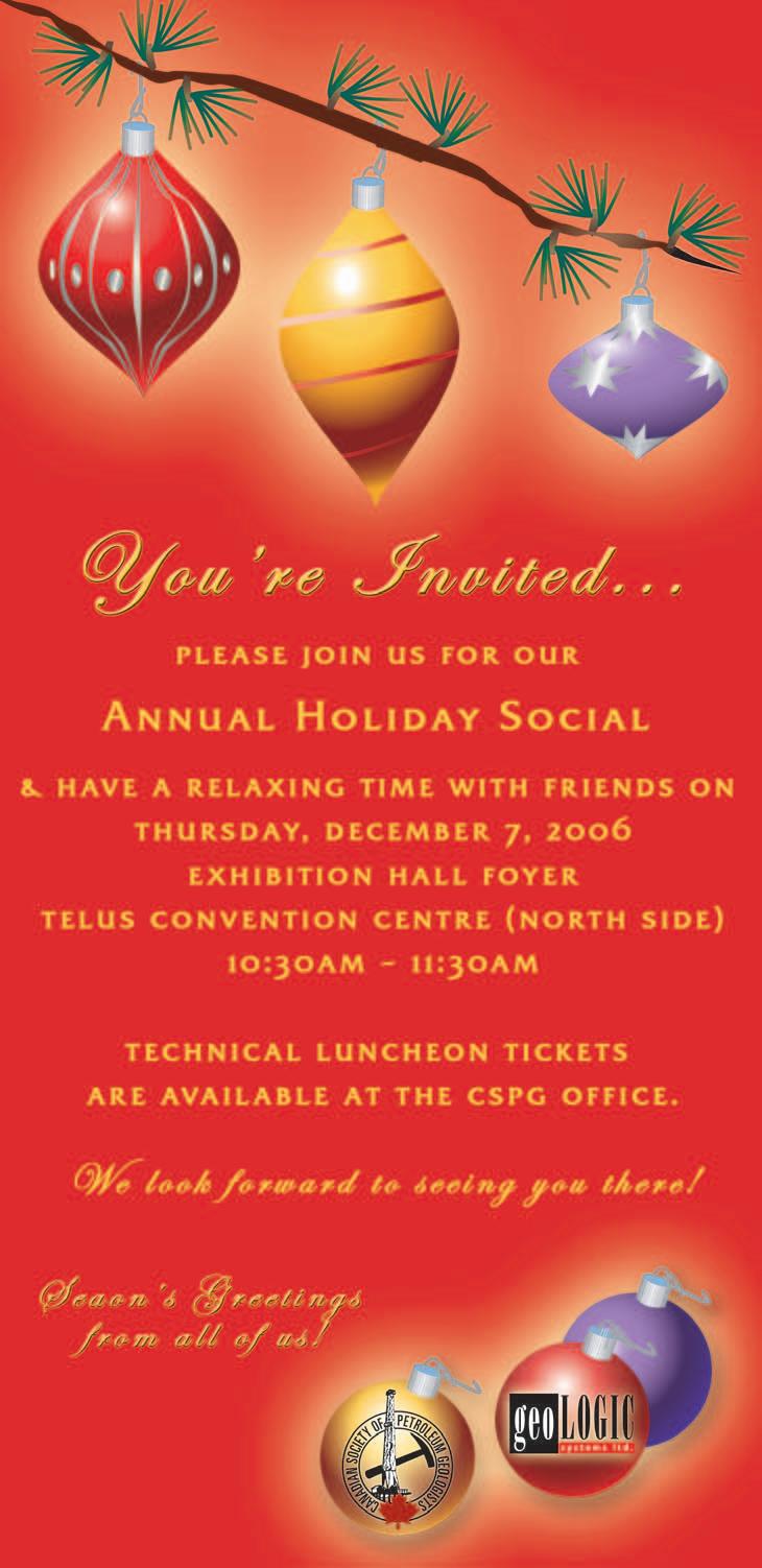
TECHNICAL LUNCHEONS
DECEMBER LUNCHEON
The Great Asian Tsunami and its aftermath
SPEAKER
Alan V.Morgan University of Waterloo.
10:30-11:30 am
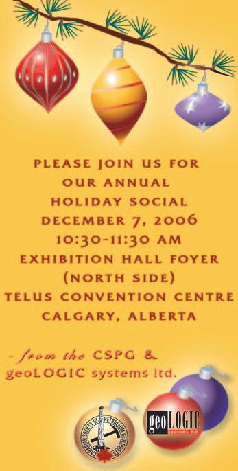
CSPG Annual Holiday Social Exhibition Hall Foyer
11:30 am Thursday,December 7,2006
TELUS CONVENTION CENTRE CALGARY, ALBERTA
Please note:
The cut-off date for ticket sales is 1:00 pm,Monday,December 4th. Ticket price is $31.00 + GST.
TSUNAMI!
On December 26,2004 most of the western world awoke to the fact that a massive force 9 earthquake had rocked the area from northern Sumatra to the Andaman Islands in
(...Continued from page 5)
OPERATIONS
The Society's operations consist of office expenses,staffing,finance and banking, amortization,and administration.Revenues, mostly from investments and corporate relations were offset by salaries and office costs resulting in a deficit of $594,000.The CSPG moved offices at the end of the 20052006 fiscal year.Given that Calgary is home to some of the highest office space costs in the world,your Executive and the CSPG's Business Manager,Tim Howard,negotiated a fantastic agreement in our new office space at 600 - 640 8 Ave S.W.,where we are now co-located with the CSEG.Managing operating expenses will be an annual challenge for future CSPG Executive Committees.
INVESTMENTS
The CSPG's long-term investment portfolio consists of 70% income investments and 30% equity investments.At our fiscal year end,our portfolio had a market value of $992,000 against a book value of $911,000. Our long term investment portfolio now comprises approximately half of the CSPG's
the Bay of Bengal.Over the course of the following hours and days,news began arriving of huge seismically generated tsunami waves that had pounded coastlines from Thailand to Sri Lanka,India,the Maldives,and even Africa.The death toll rose into the thousands,then tens and even hundreds of thousands;whole resorts had been lost,villages had disappeared,and people’s lives were changed forever.This illustrated talk explores the general origins of the tsunami;summarises,by the use of satellite images,“before and after” scenes of the devastation;and comments on some of the larger implications of tsunamis.
BIOGRAPHY
Alan V.Morgan was born in Wales and educated at the University of Leicester,the University of Calgary,and received his Ph.D. from the University of Birmingham,England. Following a post-doctoral year at the University of Western Ontario he became an Assistant professor,cross-appointed between the Department of Environment Resources Studies and the Department of Earth Sciences,at the University of Waterloo.He is currently a
Professor in the Department of Earth Sciences at Waterloo.
Dr.Morgan has promoted the public awareness of science for over 30 years,through over 750 outside lectures,three national tours,and addresses in Sri Lanka,the United States,and Europe.
Alan has received numerous teaching and service awards throughout his career,notably:
1.The Distinguished Teaching Award from the University of Waterloo in 1991,
2.The Bancroft Medal from the Royal Society of Canada in 1994,
3.The Robert H.Moss Award for Excellence in College Teaching from the National Association of Geology Teachers in 1995,
4.The E.R.W.Neale Medal of the Geological Association of Canada for outstanding efforts to communicate and explain the geosciences to the public in 1998,
5.The J.Willis Ambrose Medal of the Geological Association of Canada for sustained geological service to the community,and
6.The Waterloo Award (by the City of Waterloo) for communication of Science to the citizens of the Region.
assets.This 'Accumulated Surplus' provides a useful “rainy day” fund and reduces the Society's exposure to prolonged negative revenues in one or two key areas or unforeseen emergency expenses.
The CSPG'S staff,Executive,and volunteers have done a fantastic job in 2005-2006! I would like to personally thank CSPG Business Manager,Tim Howard,and Assistant Finance Director,Peter Harrington,for their support and hard work in helping me steward the Society's finances. Challenges remain in ensuring our annual convention,sponsorships,corporate memberships,and Bulletin and Reservoir revenues continue to flourish while operating expenses are kept in check during this vibrant time in our industry.I know that our staff and future Executives will be up to the challenge.
Thank you for providing me with this opportunity to serve the CSPG.
JANUARY LUNCHEON
Structurally-controlled carbonate diagenesis: hydrothermal dolomite and leached limestone reservoirs
SPEAKER
Graham
R Davies GDGC Ltd.
11:30 am Thursday,January 18,2007
**CSPG Annual General Meeting**
TELUS CONVENTION CENTRE CALGARY, ALBERTA
Please note:
The cut-off date for ticket sales is 1:00 pm,Monday,January 15th. Ticket price is $31.00 + GST
Structurally controlled hydrothermal dolomite (HTD) reservoir facies and associated productive leached limestones are major hydrocarbon producers in North America and are receiving increased exploration attention globally.They include multiple trends in the Ordovician TrentonBlack River and equivalents (locally,Silurian and Devonian) of the Michigan,Appalachian, and other basins of eastern Canada and the United States,and in the Devonian and Mississippian of the Western Canada Sedimentary Basin.They also occur in the Devonian of Australia,in Jurassic horsts along rifted North and South Atlantic margins,and in the Jurassic-Cretaceous of the Arabian Gulf region and elsewhere.
Hydrothermal dolomitization is defined as dolomitization occurring under burial conditions,commonly at shallow depths,by fluids (typically very saline) with
temperature and pressure higher than the ambient temperature and pressure of the host formation.The latter commonly is limestone.Proof of a hydrothermal origin for HTD reservoir facies requires integration of burial-thermal history plots, fluid-inclusion temperature data,and constraints on timing of emplacement.
Hydrothermal dolomite reservoir facies are part of a spectrum of hydrothermal mineral deposits that include sedimentary-exhalative (SEDEX) lead-zinc ore bodies and HTDhosted Mississippi Valley-type (MVT) sulfide deposits.All three hydrothermal deposits show a strong structural control by extensional and/or strike-slip (wrench) faults,with fluid flow typically focused at transtensional and dilational structural sites and in the hanging wall or down-thrown block.Structural sags interpreted most commonly as transtensional pull-aparts above negative flower structures on wrench faults are favored drilling sites for HTD exploration.
Saddle dolomite in both replacive and voidfilling modes is characteristic but not necessarily diagnostic of HTD facies.For many reservoirs,matrix-replacive dolomite and saddle dolomite appear to have formed near-contemporaneously and from the same fluid and temperature conditions.Original host facies exerts a major influence on the lateral extent of dolomitization,resultant textures,pore types,and pore volume. Dilational breccias,zebra fabrics,shear microfractures,and other rock fabrics record short-term shear stress and porefluid-pressure transients,particularly proximal to active faults.Internal dolomite sediments within faults and fractures, variably cross-bedded and scoured,add to the record of episodic fluid-flow dynamics.
High-temperature hydrothermal pulses may leave a record of thermal transients in altered kerogens and bitumen in the dolomite.Basement highs,underlying sandstone (and/or carbonate?) aquifers (probably overpressured),and overlying and internal shale seals and aquitards also may constrain or influence HTD emplacement.
Carbonate (particularly calcite) solubility is affected by variations in composition, temperature,partial pressure of CO2,pH, salinity,and other parameters of circulating fluids.Leached limestones,often with a high micropore component,typically are developed stratigraphically above and/or lateral to zones of hydrothermal dolomite (although the latter association may be obscure).Leaching may show a close control by original facies and/or structural conduits. Saddle dolomite crystals often are dispersed within the leached limestone.Implications are that cooler,Mg-depleted fluids have leached the limestones,but mechanisms remain debatable.Leached limestones with HTD associations in the WCSB occur in the Slave Point,Jean Marie,and Wabamun formations.
Although post-evaporite brines are considered to be a major source for Mgenriched fluids contributing to dolomitization in many basins,particularly for the Devonian of the WCSB,there are some basins where there are no preserved evaporites or where the age of evaporite formation is incompatible with timing of dolomitization.Further,with the increasing recognition that major dolomite trends (for example,the Ordovician Lima-Indiana trend of the northeastern US) are hydrothermal in origin,huge volumes of fluid (or large volumes of recirculating fluids) must be
Rely on Veritas experience to maximize your exploration success. We deliver leading seismic imaging technologies, immense cluster capacity and a talented team of experts. When quality and service are top priorities, Veritas is the right choice.
Experience Veritas.
Calgary: 403.205.6000
SEISMIC ATTRIBUTES
Work with Veritas and experience the advantages of reliable, petrophysicallymeaningful solutions, from seismic all the way through reservoir characterization.
Meaningful Solutions
> fit-to-purpose approaches to meet specific challenges
> AVO, LMR, Fracture Analysis, Spectral Decomposition, Converted- and Shear-wave analysis and registration, and much more
> physically meaningful attributes
> analysis to derive multi-attribute relationships
> calibration with well logs and geologic data
Real World Experience
>unconventional gas plays
>heavy oil
>tight gas
>shale gas
>coal bed methane
>pore pressure prediction
>lithology, fluid and porosity models
Relevant Expertise
> dedicated research teams focused on solving clients’ exploration and development problems
involved to account for the volume of dolomite and source of Mg.Although these mass-balance problems are the same for large volumes of dolomite regardless of type,the connection between sags, basement-rooted wrench faults,and thermal anomalies for hydrothermal dolomite (and other hydrothermal mineral deposits) suggests a possible linkage to other “nonseawater derived” sources of Mg.Further, there are questions still to be resolved concerning the pressure dynamics of fluid flow up faults.Published data for San Andres wrench faults in California indicate extremely high but episodic fluid flow rates, with implications for advective heat (and solute) transfer and non-equilibrium diagenetic conditions.
As exploration for structurally-controlled HTD and leached limestones continues and/or as this type of diagenetic control on carbonate reservoir development is more widely recognized,it is clear this is a highrisk play.This is inherent in the variability of reservoir characteristics in a fault-driven fluid-flow system.Original coarser-textured,
JANUARY LUNCHEON
Tectonic and climatic forcing of high-frequency sequence stratigraphy:processes and products in fluvial environments
SPEAKER
Andrew D.Miall
Department of Geology University of Toronto
11:30 am Thursday,January 25,2007
TELUS CONVENTION CENTRE CALGARY, ALBERTA
Please note:
The cut-off date for ticket sales is 1:00 pm,Monday,January 22,2007. Ticket price is $31.00 + GST.
Stratigraphic studies are yielding increasing evidence for sequence controls operating over time scales of 103-104 years.Highfrequency tectonism (in tectonically active basins) and high-frequency glacioeustasy generate sequences by the forcing of changes in accommodation.
shallower-water limestones in high-energy shelf and shelf-margin settings are preferred hosts for more porous and permeable HTD and leached limestone reservoirs.“A holistic approach involving field relationships, structural geology,seismic interpretation, stratigraphy,geochemistry,fluid inclusion analysis,petrography,hydrology,rock mechanics,and more” (L.Smith,NYSM,pers. comm.,2006) is necessary.Regional and high-resolution aeromag (and gravity) mapping,structural mapping (with residuals), and 2D – or preferably – 3D seismic imaging with seismic anomaly mapping,are incremental steps in defining targets. Horizontal drilling,ideally directed oblique to linear (wrench) fault trends,may help to reduce risk of reservoir variability.
BIOGRAPHY
Graham Davies received his B.Sc.honours and Ph.D degrees from the University of Western Australia in Perth,W.A.His doctoral thesis was on modern carbonates of Shark Bay,W.A., published in AAPG Memoir 13.After a postdoctoral fellowship with James Lee Wilson at Rice University in Houston,he joined the Geological Survey of Canada (GSC) in Calgary.
After seven years with the GSC,Graham cofounded and became principal owner (and named the company!) of AGAT (Applied Geoscience and Technology) Consultants,later Laboratories,in Calgary,for a time with offices in Denver.Since 1983,he has operated through GDGC Ltd.Graham has published about 75 papers on the geology of Australia and Canada, and has authored or co-authored more than 650 consulting reports for the petroleum industry in Canada and internationally.He has received many awards and recognition for both published papers and oral presentations from the AAPG,the CSPG,and the GSA.In 2002, Graham received the R.J.Douglas Medal of the CSPG for 'outstanding and continuing' contributions to Canadian sedimentary and petroleum geology,mainly for his work on Arctic Paleozoic carbonates and evaporites,and on the Triassic of western Canada.He is co-editor of a special issue of the AAPG Bulletin (November, 2006) on hydrothermally-altered carbonate reservoirs,and is principal author of a major review paper on hydrothermal dolomite reservoirs in that volume.Graham's research in this field is supported by a grant from the Quest Foundation.
PROUD SPONSORS
Orbital forcing of climate change causes latitudinal shifting of climate belts,with consequent effects on sedimentary environments,including changes in temperatures,atmospheric and oceanic circulation,biological productivity,and other factors.In nonmarine settings,climatic fluctuations in rainfall lead to changes in vegetation and sediment yield,with effects on fluvial sedimentation patterns,including channel style,and overbank facies.
Orbital forcing has been called a sedimentary pacemaker,and offers potential for the development of a high-precision time scale.However,the building of an orbital time scale from the ancient rock record requires assumptions about the constancy of orbital periods and the completeness of the stratigraphic record which it may not be possible to satisfy.
In the rock record,cycles driven by orbital forcing have long been recognized,going back to the definition of Mid-Continent cyclothems in the 1930s.More recently, mapping in many basins,such as the Cretaceous of the Western Interior,has indicated that changes in climate,without
any effects on eustatic sea level,have generated a high-frequency sequence stratigraphy.Such cyclicity may provide many markers for high-precision mapping,but in nonmarine settings the superimposition of autogenic channel migration and avulsion processes may be on a time scale unrelated to orbital forcing and may result in a highly fragmentary record of climatic cyclicity.
BIOGRAPHY
Andrew Miall obtained his B.Sc.at the University of London (UK) in 1965,and his Ph.D.at the University of Ottawa in 1969.He was employed by J.C.Sproule and Associates and by Shell Canada until 1972,at which time he joined the Arctic Islands section of the Geological Survey of Canada,Calgary,where he worked on regional basin studies.In 1979 he moved to the University of Toronto,and is founding incumbent of the Gordon Stollery Chair in Basin Analysis and Petroleum Geology. Andrew was elected a Fellow of the Royal Society of Canada and a Distinguished Fellow of the Geological Association of Canada in 1995. In 2004 he was a recipient of the American Association of Petroleum Geologists Grover E. Murray Distinguished Educator Award.
ROCK SHOP
DIVISION TALKS
STRUCTURAL DIVISION
True stratigraphic thickness (TST);an important element in the exploration for Foothills oil and gas reserves
SPEAKER
Andrew C.Newson Moose Oils Ltd
12:00 Noon
Thursday,December 14,2006
Petro-Canada
West Tower, room 17E (17th floor)
150 6th Ave SW
Calgary, Alberta
One of the great unknowns for the Foothills explorationist is the true stratigraphic thickness of a bed.Finding a formation that is unaffected by faults,steep dips,or deviated bore holes is difficult.This thickness has an impact on many aspects of the exploration and development of hydrocarbons in the Foothills:
• Velocity models for seismic depth conversion
• Well prognoses
• MWD well monitoring
• Structural interpretation of objective horizons
• True thickness for sequence stratigraphic interpretation
• Balanced cross-section construction
• Reserve calculations
In this talk we will look at RDA and see how it has used three-dimension trigonometry and interactive windows to correct a suite of logs. In this software package the programmer has used a novel technique to interpolate between dip points.This is done by rotating the poles to the dips along the great circle containing the adjacent poles to dip.By using the eigenvector analysis to average the data an accurate TST calculation can be then made in zones of highly variable dip density.
To illustrate the functionality of this technique, we will look at two examples from Foothills. The first one from the BC Foothills will illustrate this technique by converting a log suite from MD to TST in a Triassic fold.The second example from Alberta will use these calculations to correct the MWD gamma to TST.This allowed the operator to GeoSteer a horizontal well so that it stayed in a thin undulating reservoir horizon.At the same time the prognosis tool enabled the geologist and drilling engineer to predict intra-formation
tops given a variety of drilling scenarios, thereby reducing the engineering risk and contributing to a successful gas well.
RDA is the dipmeter interpretation package from ResDip Systems,Houston,Texas.www.resdip.com
BIOGRAPHY
Andrew Newson has nearly 35 years of experience in the geological and geophysical evaluations of overthrust belts.He is a Professional Geological Consultant registered in the province of Alberta and is currently living in Calgary.Andrew graduated in 1972 with a B.Sc.(Hon) in geology from London University,England.Since then he has worked as a structural geologist specializing in the exploration and exploitation of hydrocarbon prospects in overthrust belts around the world.Andrew has been recipient of numerous awards.Among them was the Canadian Association of Petroleum Geologists's Link Award in 2000 for his talk “Foothills,The Future for Exploration”.In addition to his consulting, Andrew has contributed to the industry in numerous professional associations such as the CSPG,CSEG,CIM,SEG,AAPG,and PESGB.He is a regular speaker at conferences both domestically and internationally and has undertaken numerous roles as technical editor and chairperson for the CSPG structural geology group
STRUCTURAL DIVISION
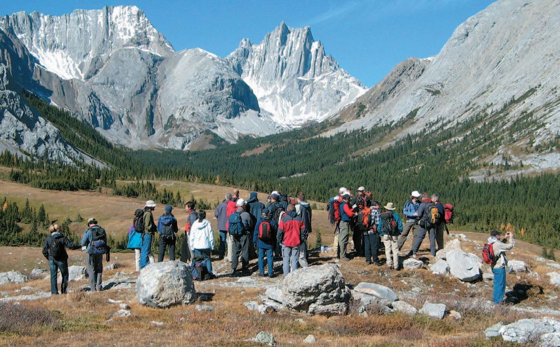
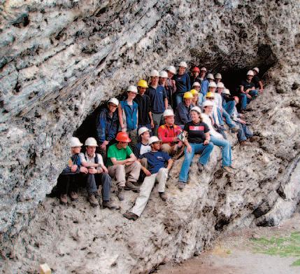
2006 Workshop/Fieldtrip
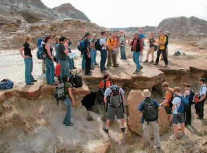
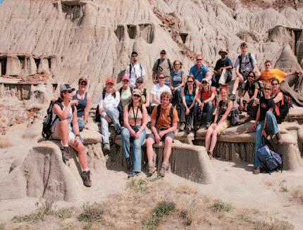
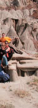
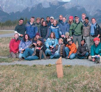
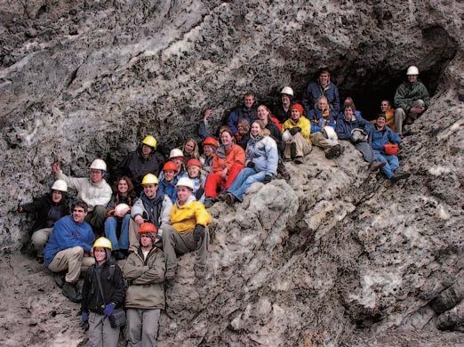
The Structural Division of the CSPG hosted a two-day workshop/field trip on September 26 and 27,2006 in Kananaskis Country.The central topic was “lateral structural changes in thrust belts.” The first day of this event was devoted to presentations (in the comfort of a conference room in Kananaskis village) and the second to road stops and hikes to
various features between Porcupine Creek and Highwood Pass.A total of 38 geoscientists attended,representing both federal and provincial geological surveys, the two main Alberta universities and many companies of the Calgary oil patch.
Both conference room and outcrop presentations were made by a large number of the attendees,and the associated discussions (arguments) were
abundant and productive.The format and venue worked very well,and the weather cleared for a spectacular hike to Desolation Pass (see photo).Thanks,in particular,to Anadarko Canada for providing a bus,to Petro-Canada for providing the projector and roadside safety equipment,and to Elizabeth Atkinson for handling the bulk of the logistics.
CONGRATULATIONS: CALGARY HALL OF FAME
There are many outstanding members of the petroleum industry that are well known among their peers for their contributions to our profession and to society in general. Although many don’t always get the public recognition that they deserve,two giants of the energy industry recently were recognized for their efforts.
James Carl (J.C.) Anderson and Clayton H. (Clay) Riddell were announced as 2006
nominees for the Calgary Business Hall of Fame by Junior Achievement of Southern Alberta.The Calgary Business Hall of Fame, in support of Junior Achievement of Southern Alberta,honours men and women for their outstanding contributions to business,entrepreneurship,and philanthropy.
Members of the Business Hall of Fame serve as inspiring examples for all young
Canadians and are featured in a permanent exhibit located in the Bankers Hall East Tower Lobby.
For more information,please contact the Junior Achievement office at 237-5252 or www.jasouthalberta.org.
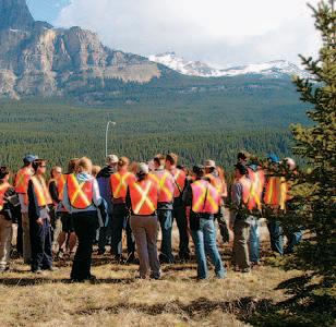
View along strike to the north from Desolation Pass.Devonian and Mississippian carbonates within the Misty and Rundle thrust sheets have been offset across several major tear/transverse faults.Photo by Don Buscarello.
PALAEONTOLOGY DIVISION
Silent movie monsters: Sir Arthur Conan Doyle's "The Lost World" on the silver screen
SPEAKER
Cory Gross
7:30-9:00 PM
Friday,December 15,2006
Mount Royal College Room B108
4825 Mount Royal Gate SW Calgary, Alberta
Since its release in 1925,the first screen adaptation of Sir Arthur Conan Doyle's "The Lost World" has gone down in history as the seminal dinosaur action movie.
Originally planned by filmmaker William Selig,
"The Lost World" was eventually produced by Watterson R.Rothacker and First National Pictures,utilizing the stop-motion techniques of special effects legend Willis O'Brien.
The total production required three years of animation with 50 models,eight weeks of principal filming,2,000 extras,and $1,000,000 to produce.Based on the paintings of pioneer paleo-artist Charles Knight,the dinosaur models remain the most accurate ever seen in film based on what science knew at the time.Receiving much critical acclaim, "The Lost World" also became the world's first in-flight movie.
This talk will trace the history and controversy surrounding the production and include heretofore unpublished research from the archives of the Academy of Motion Picture Arts and Sciences.
The presentation will be held in conjunction with a Christmas Social,please bring a snack to be shared.All ages are welcome.
BIOGRAPHY
Cory Gross began his post-secondary education studying geology,and has recently finished a degree in Museum and Heritage Studies.Cory also operates the internet's most extensive website devoted to "The Lost World," which celebrates its 10th anniversary in 2007.
INFORMATION
This event is jointly presented by the Alberta Palaeontological Society,Mount Royal College, and the CSPG Palaeontology Division.For information or to present a talk in the future please contact CSPG Paleo Division Chair Philip Benham at 403-691-3343 or programs@ albertapaleo.org.Visit the APS website for confirmation of event times and upcoming speakers:http://www.albertapaleo.org/
EMERGING PETROLEUM RESOURCES DIVISION
Hydrogeological settings for shallow coalbed methane exploration areas in southeastern British Columbia and the west-central Plains of Alberta – a comparison
SPEAKER
Shane Harrison
SH Consulting Services
12:00 Noon
Wednesday,December 13,2006
ConocoPhillips Auditorium
(3rd Floor - west side of building)
401-9th Avenue SW Calgary, Alberta
Numerous studies show that carbon and hydrogen isotope data,methane gas,and formation water chemistry derived from organic-rich facies can be reliable indicators of in-situ generation of methane and carbon dioxide through methanogenesis.The methanogenic process and its effect on water chemistry has been illustrated and described in the San Juan Basin,Powder River,and Michigan basins of the United States.A particularly widely known example of microbial gas charging in coal basins is in the Powder River Basin,in which relatively immature coals predominate and
groundwater has also been shown to participate in real-time addition of migrated gas or in active generation of gas near anticlinal structures.
The Elk Valley coalfield and the Ardley coals (in part) of the Alberta Plains are among coalbed methane exploration areas in western Canada which appear to show similar trends.The basins,although each in a unique physical and hydrogeological setting, share some characteristics – particularly in formation water chemistry and the isotopic compositions of gases,which appear to be,in part,controlled by microbial activity (i.e., methanogenesis).Among the more important of these characteristics are:
• anomalous concentrations of HCO3 (bicarbonate or DIC) enriched in 13C,
• CH4 depleted in 13C,and
• formation and,in many instances,local- and basin-scale hydrodynamics.
Permeability,water chemistry (including stable isotope compositions),and the carbon geochemistry of gases will be compared and contrasted in each area.The data show that relatively active groundwater flow can be recognized based on one or more of formation pressures,groundwater chemistry, and oxygen and hydrogen (2H and 3H) isotopes.Exploration and production / development scenarios will be examined
within the context of these data and the hydrogeological setting.
BIOGRAPHY
Shane is a professionally registered geologist in Alberta with a well rounded background in earth sciences applied in compiling,assessing, analyzing,synthesizing,and reporting information for hydrogeological assessments. His experience is varied and includes CBM / shallow gas resource evaluation / development in Saskatchewan,Alberta,and British Columbia. His work has included 3-D flow modeling; isotopic studies of groundwater and dissolved gases;hydrodynamics and inorganic/organic geochemistry of groundwaters used in prospect characterization,evaluation,exploration, producibilty,and water management studies. Work areas have included central Alberta (Ardley and Mannville),southwestern Saskatchewan,and southeastern British Columbia (Mist Mountain).
INFORMATION
EPRD noon-hour talks are free and do not require registration.Non-CSPG members are also welcome to attend.Please bring your lunch.If you would like to join our email distribution list,suggest a topic,or volunteer to present a talk,please send a message to Michelle.Hawke@bp.com.Division talks are sponsored by IHS (http://www.ihs.com)
PROUD SPONSORS
BASIN ANALYSIS DIVISION
The other ways to apply ichnology in sequence stratigraphy
SPEAKER
Murray Gingras Department of Earth and Atmospheric Sciences,University of Alberta
12:00 Noon
Tuesday,January 30,2007
EnCana Amphitheatre 2nd Floor,
East end of the Calgary Tower Complex 1st Street and 9th Avenue SE Calgary, Alberta
Trace fossils have proven to be very useful in sequence-stratigraphic analysis.Discussion of sequence stratigraphic analysis has centered around the use of substratecontrolled ichnofacies to identifying stratabounding discontinuities.However,as demonstrated earlier by workers,such as George Pemberton and James MacEachern, ichnofossil assemblages can be used to assess the salinity of an ancient sedimentary environment,the rate of sedimentation therein,and overall oxygenation at the time of sediment colonization.Taken as a whole, trace fossils provide the requisite information to identify discontinuities as having a transgressive or a regressive nature. In marginal-marine settings,trace-fossil assemblages reflect highly variable depositional conditions and their usefulness
is increased (i.e.,sequence-stratigraphic resolution is higher).In offshore settings, ichnological patterns have to be carefully considered in the context of the overall sedimentology of the deposit.
This work focuses on characterizing the character of transgressive and regressive ichnological patterns.In proximal locals, transgressive deposits are typically dominated by high-diversity assemblages of trace fossils that range in size from 1mm to 50mm in diameter.These assemblages comprise many common marine trace-fossil forms and,because sedimentation rates are lower,bioturbate textures can be highly reworked.Regressive deposits contain lowdiversity to monospecific trace-fossil assemblages that range in size from 1mm to 10mm diameter (there are exceptions to the upper size range).Moreover,by comparing trace-fossil diversity and size trends above and below suspected discontinuities,relatively small shifts in the sedimentary system can be discerned. Thereby a surface can be inferred to encapsulate a landward or seaward shift of facies.
This work is supported with examples from Cretaceous strata of the Western Canada Sedimentary Basin;most notably the McMurray Formation in the area of Syncrude,Suncor,Aurora,and Albion mines. Outcrops along the Athabasca River contain abundant ichnological evidence that suggests
significant parts of the McMurray Formation are regressive,a notable conflict with accepted estuary paradigms applied to the McMurray Formation.
BIOGRAPHY
Murray Gingras received his diploma in mechanical engineering technology from the Northern Alberta Institute of Technology in 1987,his B.Sc.from the University of Alberta in 1995,and his Ph.D.from the University of Alberta in 1999.Gingras has worked as a designer and project manager in the manufacturing industry (oil-gas separators, meter packages,etc.) and in oil and gas exploration as a geologist.Murray has taught courses in Geology at the Northern Alberta Institute of Technology,the University of New Brunswick,and the University of Alberta.His research focuses on applying sedimentology and ichnology to sedimentary rock successions,as a paleoecological tool,a reservoir-development tool,and in process-driven sedimentology.
INFORMATION
BASS Division talks are free.Please bring your lunch.For further information about the division,joining our mailing list,a list of upcoming talks,or if you wish to present a talk or lead a field trip,please contact either Steve Donaldson at 403-645-5534, email:Steve.Donaldson@encana.com or Mark Caplan at 403-691-3843,email: Mark.Caplan@ shell.com or visit our web page at www.cspg.org/ events/divisions/basin-analysissequence-strat.cfm.
Sponsored by:
JACK PORTERVIGNETTES OF CANADIAN PETROLEUM GEOLOGY
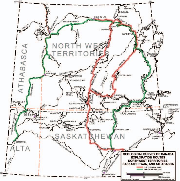
J.B. TYRRELL’S INTRODUCTION TO THE INTERIOR OF CANADA’S PRECAMBRIAN SHIELD
Continued from the November issue...
Prior to Tyrrell's task of transporting his two canoes,including equipment and provisions across the three-and-one-half-mile Elizabeth Portage,he had prevailed upon a band of Chipewyan natives to assist in the maneuver. Accordingly,he requested that they await for his party's arrival at the base of the lowermost fall,which he had named Elizabeth Falls.Later,as Tyrrell's party approached the falls and the nearby starting point of Elizabeth Portage,he sent Ithingo,one of his two Chipewyan paddlers,overland to inform the waiting natives of the approach of Tyrrell's party.Subsequently,the transfer of his cargo to the opposite end of Elizabeth Portage, near the discharge of the waters of Black Lake into the western segment of the Fond du Lac (Stone/Black) River,was expedited by the evening of the starting day,believed to be August 2,1892.Awaiting Tyrrell,at the portage's terminus,by prearrangement,were the two men he had sent from Fond du Lac post by canoe to Fort Chipewyan to convey the rock specimens he and Dowling had accumulated,pending their ongoing transport to Ottawa.
No exposures of bedrock were observed by either Tyrrell or Dowling along the portage's path.Although the name,Elizabeth Portage, denotes a single,continuous portage,it,in actuality,consists of at least two lengthy portages,as traversed by Tyrrell's party.
During the first week of August,Tyrrell's combined parties left the easterly end of Elizabeth Portage and entered the mile-wide narrows which constricts Black Lake from its large,southwest aligned bay.Tyrrell had instructed Dowling to map both the east side of the bay as well as the south and southeast side of Black Lake,while he would survey the northwest and northeast boundaries of the lake.The routes of their respective investigations would result in both parties being rejoined on the southeast side of Black Lake,where the lake receives the discharge of the eastern segment of the Fond du Lac (Stone/Black) River.
Previously,after arriving at Black Lake by way of Cree River,Wapata,and Giles Lakes,during the latter part of July,Tyrrell commenced
mapping the lake's northwest side of its southwest bay.He noted,to quote:"It's north-west shore runs for several miles along the foot of a sandstone (Athabasca Formation) escarpment 230 feet in height, which extends away toward the south-west, beyond the end of the lake,and north-east to within a short distance of Stone River." Proceeding two miles northeast,through the channel fronting the mouth of the western segment of Fond du Lac (Stone/Black) River, Tyrrell arrived at Black Lake's solitary large island.Known as Fir Island,it is 12 square miles in areal extent,having a somewhat triangular-shaped outline.By circumscribing it,Tyrrell noted that its wedge-shaped, southwest tip revealed cliffs of white,flatlying Athabasca sandstone rising to heights of 15 feet above the level of the lake. Furthermore,cliffs of similar strata,bordering the island's northwest shore,attain heights of 40 feet (Ibid.:1896,Tyrrell,J.Burr,;Athabasca and Churchill River ---- pp.51,53).
According to Tyrrell,the boundary between the Athabasca sandstone and Archean rocks
lies along the trace of the Fond du Lac (Stone/Black) River where it flows out of Black Lake.Here,10-foot exposures of massivebedded,coarse-grained sandstone,grading to a fine conglomerate,occur on the south side of the river;while igneous intrusions,consisting of large rounded mounds of reddish granitegneiss,some 50 feet in height,are present on the opposite side.No outcrops of Athabasca sandstone were evident on the north side of Black Lake.Prominent cliffs,composed of nongranitic,dark green extrusive rocks,were present along the lake's northwest coastline, which Tyrrell identified as norite;whereas its northeast extension revealed masses of red granite.
Prior to Tyrrell's investigation of the geology of the eastern segment of the Fond du Lac (Stone/Black) River,he decided that his party would confine its survey to bedrock exposed along the river's course,whereas he directed Dowling to restrict his party's mapping to the lower reaches of tributaries,including lakes linked to the river.
(Continued on page 20...)
On August 7th,1892,the combined parties of Tyrrell and Dowling commenced their ascension of the river from its outpouring into Black Lake.On the evening of August 18th, Tyrrell's party arrived at the river's intake from where it conjoins with a bay,located on the northwest side of Wollaston Lake.It was at this prearranged meeting site that Dowling's party arrived on the following day.
The ascent,by canoes,of the eastern segment of the Fond du Lac (Stone/Black) River by the parties of Tyrrell and Dowling was,literally,a most toilsome task.The 120-mile length of this eastern section of the river contains 29 stretches of rapids ranging for distances up to one mile.Associated with some of the rapids are chutes and falls,the latter having heights up to 12 feet.Nine portages,ranging from 120 yards to 1,017 yards,flank the river's route.To execute those rapids,confined to the shallower sections of the river,required either tracking or poling of the canoes.Tyrrell reports that:" Most of the rapids had been ascended by walking in the water and hauling the canoes,and in order to get a foothold on the smooth stones and to stem the swift current,the men were often naked up to their waist,and consequently suffered very severely from the black flies" (Ibid.:1896,Tyrrell,J.Burr; Athabasca Lake and Churchill River --- p.80).
The Archean red granites and associated gneisses exposed on the northeast side of Black Lake extend southeastward to the confluence of the south-flowing Porcupine River,located 10 miles upstream from the discharge of the eastern segment of Fond du Lac (Stone/Black) River into Black Lake. Here,also,are exposures of reddish and grey biotite gneisses.Two miles above Porcupine River,a rapid occurs,at whose foot the flatlying Athabasca Formation reappears.This outcrop consists of a three-foot ledge of horizontally bedded,red,coarse-grained sandstone grading to a fine conglomerate. Additional outcrops of the Athabasca Formation,occurring along parts of the river, vary from a few feet in thickness;expressed as ledges of flat-lying sandstone within the stream bed or fringing the shore of rapid sites to cliffs and walls of sandstone flanking the river and reaching heights up to 15 feet, Their lithologies are characteristically similar, consisting of white to red,medium- to coarse-grained sandstone,whose basal sections,where exposed,reveal fine conglomerates.Some of their sand matrices contain smooth,well rounded quartzite pebbles – suggestive of a basal conglomerate, whose derivation may be related to Lower Proterozoic Huronian quartzites.Following diligent searches by both Tyrrell and Dowling, they failed to discover any fossils associated
with the Athabasca Formation.Its expression in the subsurface would seem to remain without interruption along the river's course for 80 miles to within a distance of 11 miles downstream from Hatchet Lake,at the mouth of the Waterfound River.Here,its erosional edge veers south to skirt the midwestern edge of Wollaston Lake,the Formation’s most easterly expression.
On August 8th,the second day of their river travel,the parties of Tyrrell and Dowling were met by a band of Chipewyan natives two miles above Perch River,a southwest-flowing tributary of the eastern segment of the Fond du Lac (Stone/Black) River,located six miles upstream from Porcupine River.These natives occupied four or five canoes and had left Wollaston Lake three days previously.They were originally from the Reindeer Lake area and intended to rendezvous at Black Lake with local natives.Together they planned to travel north from Black Lake,crossing the Height of Land,in order to hunt for caribou, where at this season were foraging on the southern edge of the Barren Lands.Tyrrell's combined party camped alongside their new Chipewyan friends and queried them in order to obtain the nature and condition of the river they were ascending,as well as its portages.The natives also informed them of a canoe route northward from Reindeer Lake, by way of the Cochrane (Ice) River,to access Kasba (White Partridge) Lake and Kazan River.Tyrrell was later to draw on the Chipewyans' information when,in 1894,he explored this route to the Barren Lands,He was assisted by Robert Munro-Ferguson,an aide-de-camp of the then Governor General, the Earl of Aberdeen.Joseph Tyrrell's party endured a number of hardships,similar to those suffered in 1893,when,with his brother,James W.Tyrrell,were first introduced to the Barren Lands.Joseph Tyrrell and Robert Munro-Ferguson arrived on Hudson Bay's west coast on October 1st, 1894.Previously,they had abandoned the Kazan River from its lower reaches near its discharge into Baker Lake and ultimately into Chesterfield Inlet.Not wanting to repeat the previous year's difficulties,they portaged below Yathkyed Lake east to Ferguson River, which took them to the coast of Hudson Bay, a distance of some 260 miles to the north of Churchill.Following two months of rest,they continued southwest to Split Lake,a part of the Nelson River system;which took them to Norway House,reaching Selkirk,Manitoba on January 7th,1895 (Ibid.:Zaslow,Morris; Reading The Rocks ---- p.163).
No mention is made,by either Tyrrell or Dowling,of having observed in the field,an exposure,based on their mappable rock units, which exhibited the major unconformity
separating the underlying Archean (Laurentian) "Granitoid gneisses,Massive Granitic Rocks," including "norites and gabbros" or Lower Proterozoic (Huronian) "White quartzites,fine red calcareous sandstones and thinly foliated green schists" from the overlying early Middle Proterozoic (Paleohelikian) Athabasca formation (Tyrrell's Cambrian).The latter,they describe as:"Red sandstones and mottled sandy shales,in more or less horizontal position." No doubt,the relatively undisturbed,unmetamorphosed,horizontally bedded Athabasca sandstone,notwithstanding its absence of fossils,resulted in Tyrrell including it in the Paleozoic era.
By ascending the Fond du Lac (Stone/Black) River from its outpouring into the southeast side of Black Lake,Tyrrell and Dowling,along with their parties,had replicated David Thompson's discovery route,which the latter,in 1796,had surveyed from Reindeer Lake to the eastern end of Lake Athabasca. On August 12th,1892,the two geologists identified the hazardous site of Thompson's near-fatal drowning experience,which misfortune occurred 63 miles above Black lake at a point midway between the forementioned lake and Hatchet Lake,which Tyrrell named Thompson Falls.
On July 9th,1796,Thompson,in his twelfth year of service with the Hudson's Bay Company,while in the company of his two Chipewyan canoemen,Kozdaw and Paddy, arrived at a fall on the Fond du Lac (Stone/Black) River whose approach and base were the scene of extended rapids. Thompson,after portaging 600 feet to a site above the fall,decided to have his two canoemen track the canoe from the shore while he steered with one paddle,in order to guide the craft through the heavy upper rapids.After tracking 240 feet,the two natives’ path was obstructed by a Birch tree located at the water's edge.As a consequence,they were hesitant in deciding how to get around this obstacle.David Thompson,in his canoe,which contained his survey instruments and other equipment,was swept by the river's swift current into midstream.Amid the din of the fall,he was successful in instantly signaling the two natives to let go of their tracking line.On their complying,he immediately propelled himself to the bow of the canoe,following which he removed from his pocket a small knife which he used to sever the tracking line tied to the bow.Fortunately,he returned the knife to his pocket.
David Thompson's account of his continuing predicament is here narrated as follows:“...by this time I was on the head of the fall,all I could do was to place the canoe to go down
bow foremost,in an instant the canoe was precipitated down the fall (twelve feet),and buried under the waves,I was struck out of the canoe,and when I arose among the waves,the canoe came on me and buried (me) beneath it,to raise myself I struck my feet against the rough bottom and came up close to the canoe which I grasped,and being now on shoal water,I was able to conduct the canoe to the shore.My two companions ran down the beach to my assistance;nothing remained in the canoe but an axe,a small tent of grey cotton,and my gun,also a pewter basin,When the canoe was hauled on shore I had to lay down on the rocks,wounded, bruised,and exhausted by my exertions.The Indians went down along the shore,and in half an hour’s time returned with my box, lined with cork,containing my Sextant and a few instruments and papers of the survey Maps &c.and our three paddles.We had no time to lose,my all was my shirt and a thin linen vest,my companions were in the same condition,we divided the small tent into three pieces to wrap round ourselves,as a defence against the flies in the day,and something to keep us from the cold at night, for the nights are always cold.On rising from my rocky bed,I perceived much blood at my left foot,on looking at it,I found the flesh of my foot,from the heel to near the toes torn away,this was done when I struck my feet against the rough bottom to rise above the waves of the fall of water.A bit of my share of the tent bound the wound,and thus barefooted I had to walk over the carrying places with their rude stones and tanks.The Indians went to the woods and procured Gum of the Pines to repair the canoe,when they returned,the question was how to make a fire,we had neither steel,nor flint,I pointed to the gun from which we took the flint.I then produced my pocket knife with it's steel blade,if I had drawn a ghost out of my pocket it would not more have surprised them,they whispered to each other,how avaricious a white man must be,who rushing on death takes care of his little knife,this was often related to other Indians who all made the same remark.I said to them if I had not saved my little knife how could we make a fire,you fools go to the Birch Tree and get some touchwood,which they soon brought,a fire was made,we repaired our canoe,and carried all above the Fall and the rapid,they carried the canoe,my share was the gun,axe, and pewter basin;and Sextant Box.Late in the evening we made a fire and warmed ourselves." (1962,David Thompson's Narrative 1784 - 1812;ed.Richard Glover, The Champlain Society,Toronto;ptd.Robert MacLehose and Company,Ltd.,University Press Glasgow,p.I18).
To be continued...
Focusing on Gas?
Now there is a better method for identifying gas and measuring gas saturation in cased holes. Baker Atlas is proud to introduce the GasViewSM service, a high-resolution measurementand analysis service that produces an exceptionally clear picture of reservoir gas.
Using Baker Atlas’ RPMSM pulsed neutron system, the GasView service can be used to measure reservoir gas in virtually any well. Applications range from identifying by-passed pay in wells nearing abandonment to openhole log replacement for new wells.
Contact your Baker Atlas representative today to learn how the GasView service can help you produce more gas with greater efficiency.
CANADIAN SOCIETY OF PETROLEUM GEOLOGISTS
2007 EXECUTIVE COMMITTEE
The Canadian Society of Petroleum Geologists takes great pleasure in announcing the Executive Committee for 2007. The new Executive will take office following the Annual General Meeting at the Telus Convention Centre on January 18,2007.
PRESIDENT – COLIN YEO, P.Geol.
BIRTH: Dundas,Ontario (1951)
EDUCATION: Hons.B.Sc.Geology and Geography,McMaster University (1974)
EXPERIENCE: 1974-1999,Geologist,Petrophysicist and Team Leader exploration,exploitation and production business units, Amoco Canada Petroleum Co.Ltd.;1999-2000,Evaluation Geologist,Acquisitions and Divestitures,Petrorep Resources Ltd.;2000-present,Technical Advisor,Area Manager Shallow Gas Business Unit,Evaluation Geologist Acquisition and Divestitures,EnCana Corporation.
PROFESSIONAL MEMBERSHIPS: CSPG,APEGGA,CSEG,CWLS,AAPG
CSPG ACTIVITIES: Media and Public Affairs (1977-1980),Art Event (1985-1987),History and Archive Committee (1988-1992), Annual Convention Core Conference Chairman (1995),Executive Committee Services Director (1999-2000), Volunteer Management Committee (2001-present)
PUBLICATIONS: Co-authored papers on exploration activity in the WCSB;conducted many field trips within the CalgaryBanff corridor;several presentations to high school students in Alberta
AWARDS: Service and Volunteer Awards (1992,2002,2004)
VICE-PRESIDENT – LISA GRIFFITH
BIRTH: Bellefonte,Pennsylvania (1955).Moved to Canada in 1966.Dual citizenship.
EDUCATION: B.A.,Rice University (Houston) (1977);M.Sc.Geology,U.of Calgary (1981)
EXPERIENCE: 1980-1985,Geologist,Esso Resources Canada;1985-1992,Geologist,Lead Development Geologist,Regional Clastics Specialist,Amerada Hess Canada;1992-1993,Consulting Geologist,W.R.May and Assoc.;1993-2002, Sr.Geologist,Staff Geologist,Senior Clastics Specialist,PanCanadian/Encana;2003-2004,Chief Geologist, GEDCO;2004-present,President,Griffith Geoconsulting Inc.
PUBLICATIONS: Numerous conference abstracts discussing Cretaceous clastic formations for oral presentations,posters (CSPG,AAPG),and core displays (CSPG).(Primary author 1980,1986,1995,2002,2003;co-author 1995, 1997,1998,2000,2001,2003,2004.) CIM Preprint Paper No.88 39-50 (1988) (Cardium Fm);Cardium chapter co-author,Geology of the Calgary Area,CSPG Publication (1987).
AWARDS: CSPG-CWLS Best Oral Presentation (1995),CSPG Link Award (1996),SEPM Best Oral Presentation (1997, co-author),CSPG-CSEG Best Integrated Core Presentation (2003)
FINANCE DIRECTOR – PETER HARRINGTON
BIRTH: Pembroke,Ontario (1961)
EDUCATION: B.Sc.Geology,Carleton University (1984);MBA,University of Calgary (1991)
PUBLICATIONS: Various oral and poster presentations at CSPG conventions focusing on exploration activity and successes in the Western Canada Sedimentary Basin
AWARDS: CSPG Service Awards (1989,1997,2000);CSPG Tracks Awards (1991,1996);People's Choice Award for an Oral Presentation,GeoCanada 2000 Convention (Continued on page 26...)
At 40, the University of Calgary is hitting its stride — nearly 30,000 students, 110,000 alumni, 16 faculties, 53 departments and more than 30 research institutes and centres. Campus Calgary Digital Library, ISEEE (the Institute for Sustainable Energy, Environment and Economy), Urban Campus and our Faculty of Veterinary Medicine secure our position as a leader in North America’s research community.
The Department of Geology and Geophysics at the University of Calgary has instituted a Bachelor of Science with a concentration in Petroleum Geology program and Master of Science in Reservoir Characterization program and anticipates hiring several faculty members over the next three years in order to deliver these new programs. At this time, the department invites applications for five full-time tenure-track positions.
The positions:
We are currently inviting applications for the following positions:
Tenure-Track Instructor or Senior Instructor, Geology or Geophysics (2 positions)Assistant Professor, Petroleum Geology
Associate Professor,Reservoir GeophysicistAssociate or Full Professor, Petroleum Geologist
The Faculty of Science at the University of Calgary has instituted a Bachelor of Science program in Natural Sciences with a concentration in Energy. The Department of Geology and Geophysics invites applications for a research Hydrologist or Hydrogeologist to deliver courses for this program.
The position:
Wearecurrently inviting applications for the following position:
Assistant Professor, Hydrologist or Hydrogeologist
Further information about the Department is available at www.geo.ucalgary.ca.
All qualified candidates are encouraged to apply; however, Canadians and permanent residents will be given priority. The University of Calgary respects, appreciates and encourages diversity. To see these University of Calgary academic positions, please visit www.ucalgary.ca/hr/career.
ASSISTANT FINANCE DIRECTOR – JAMES DONNELLY
BIRTH: Pembroke,Ontario (1955)
EDUCATION: B.Sc.University of Toronto (1979);B.Sc.Geology,University of Calgary (1982)
EDUCATION: B.Sc.Geology,Mount Allison University (1974);M.Sc.Geology (Glacial Sedimentology),University of Alberta (1979);Ph.D.Geology (Fluvial Sedimentology),McMaster University (1987)
EXPERIENCE: 1978-1979,stratigraphy and grade control,Mildred Lake Mine,Syncrude Canada Ltd.;1979-1981,operations and technical group,Amoco Canada Petroleum Company Ltd.;1986-1989,project geologist,Precambrian sedimentology,Ontario Geological Survey;1989-1993,Post-Doctoral Fellow/Adjunct Professor,Carleton University,Ottawa;1993,Assistant Professor,American University of Beirut,Lebanon;1994-1995,regional geologic mapping,Capital Resources Ltd./St.Francis Xavier University;1996-2000,Carlin-type gold exploration, Campbell Resources Ltd.;2001-2003,Project Lead,MVT Pb-Zn,Alberta Geological Survey; 2003,Team Lead,Regional Geological Study,Alberta Energy and Utilities Board;2005-2006,Oil Sands Section, Geology and Reserves Group,Alberta Energy and Utilities Board;2006-current,Firebag In-Situ Group,Suncor Energy Inc.
CSPG ACTIVITIES: 2002 Diamond Jubilee Convention – Registration Sub-Committee;2001 Rock the Foundation Convention –Registration Chair;1999 Digging Deeper Convention – Registration and Logistics Chair
AWARDS: CSPG Service Award (1999,2001,2002).
FOR PINPOINTING NEW TARGETS
FOR PINPOINTING NEW TARGETS
Boyd PetroSearch gives you a decisive exploration advantage.
As leaders in geophysical interpretation for over 25 years, Boyd PetroSearch helps you make decisions with far greater accuracy and confidence than ever before.
Find out how we can improve your ability to drill on target by revealing complex interrelated geological features and reservoir patterns with unprecedented resolution and detail.
Please call:
John Boyd 403.543.5373
Larry Herd 403.543.5362 or visit www.boydpetro.com
Supporting the development of natural energy resources
diverse experience
RPSEnergy is an international consultancy providing support and advice on the development of natural resources,the management of the environment and the health & safety of people.
ASSISTANT SERVICE DIRECTOR – JAN VEZINA
BIRTH: Chapleau,Ontario (1968)
EDUCATION: B.Sc.Honours,Geology,Queen's University (1992);M.Sc.,Geology,University of Alberta (1996).
EXPERIENCE: 1997-1998,Geologist,Upton Resources Inc.;1999,Contract Geologist,Coastal Oil and Gas Canada,Inc.; 1999,Contract Geologist,Graham Davies Geological Consultants;1999-2000,Contract Geologist,Apache Canada Limited;2000-2006,Geologist,NAL Resources.
PROFESSIONAL MEMBERSHIPS: CSPG
CSPG ACTIVITIES: 1999 CSPG & Petroleum Society Joint Convention Field Trip Committee Co-Chair.
PUBLICATION: Quaternary sea-level highstands from Th/U dating of aragonitic corals,Journal of Sedimentary Research
CSPG ACTIVITIES: Student Industry Field Trip (SIFT) co-leader,1999-2005;Associate Editor,Bulletin of Canadian Petroleum Geology,2001-2003,2005-2007.
PUBLICATIONS: Papers on Cordilleran and Appalachian geology;conference presentations on oil and gas geology.
AWARDS: CSPG Volunteer Appreciation Award;GSC Service Award
PAST PRESIDENT – JIM REIMER
BIRTH: Kitchener,Ontario (1955)
EDUCATION: Hons.B.Sc.Geology,University of Waterloo (1978);M.Sc.Geology,University of Waterloo (1980); Canadian Securities Course (1997)
EXPERIENCE: 1980-1994,Home Oil Company Ltd.;1995-1996,Stampeder Exploration Ltd.;1997-2001,Encal Energy Ltd.; 1999-2001,2002-2003,Race Rocks Resources Ltd.;2004-present,Result Energy Inc.
PUBLICATIONS: Numerous oral papers and short course notes concerning the occurrence and origin of Hydrothermal Dolostones (HTD) and related facies
AWARDS: CSPG Undergraduate Award (1977);Best Convention Paper (1991);CSPG Link Award (1994);CSPG Tracks Award (1996);CSPG President’s Award (1998)
STRATEGIES TO SUCCESSFULLY MANAGE LONGEVITY
LONGEVITY RISK IS THE RISK OF OUTLIVING YOUR MONEY.
Who would have thought that certain hardliving rock stars would still be alive today? Now in their 60s,they're likely to be with us for many years to come.Could they be contemplating longevity risk? Probably not,but for the rest of us longevity risk is a real concern.
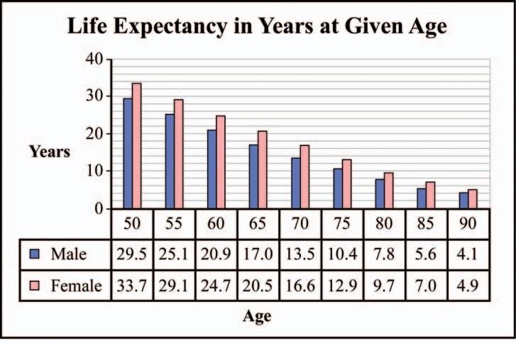
Theoretically,conventional investment planning provides accumulated wealth to last a lifetime – for men,78 years and for women,82 years.1 In reality,only four per cent of people actually die in the last year of their expected life span.2 For a 65-year-old couple living today, there is a one-in-four chance that one of them will reach 97 years of age,and a one-in-two chance that one will reach the age of 92.This unexpected increase in life expectancy puts enormous pressure on retirement funds.Since most people wait until age 50 to get serious about saving for retirement,they leave themselves only 15 years to accumulate enough assets to fund a minimum of 20 years in retirement.
The financial implications of living longer than expected beyond the core income-earning years are significant.
In 1920,five per cent of Canada's population was over age 65;by the year 2020,that figure will be closer to 20 percent.3 The Baby Boom generation will continue to represent a powerful social and economic segment of Canadian society,whose impact on traditional notions of retirement preparation will be significant – not only for themselves,but also for the marketplace expected to sustain them. A recent survey indicated that Canadian Boomers intend to lead active lives in retirement vis-à-vis their contemporary counterparts,which means their spending is unlikely to decline dramatically in the postemployment years.As a corollary of living longer and spending more in retirement, Boomers face the very real possibility of outliving their assets.
The “new retirement” will require investment plans that go beyond life expectancy.Some of the strategies to insure income for life include:
1.Allocating a portion of one's portfolio to annuities.Life annuities are a very effective choice because they guarantee the annuitant income for the rest of his or her life. 2.Choosing tax-efficient investments to maximize income potential.For example, certain common shares pay out regular
Source:Canadian Life Expectancy Table,2001,Statistics Canada
dividends – income that is taxed more favourably than interest income.
3.Purchasing permanent life insurance,the proceeds of which can be converted to a life annuity that will provide income for life for a surviving spouse.
INCOME FOR LIFE
Including annuities in an investment portfolio is probably one of the most effective methods to provide guaranteed income.An annuity is essentially a promise of income for life or for a specified period of time.Think of it as the opposite of a mortgage.Instead of borrowing a lump sum initially and then paying the loan back over a number of years,an annuity provides guaranteed income payments in exchange for an “up front” lump sum deposit. A life annuity will provide income for as long as the annuitant lives.
Like many investment vehicles,there is no shortage of annuity options.They can be offered on a single or joint life,indexed for inflation,and purchased with registered or non-registered money.Generally,the older the annuitant,the higher the income payment that person will receive.The yields for annuitants who live beyond their life expectancy tend to be higher than those of GICs,T-bills,etc., because the money invested in annuities is pooled.Some annuity investors will not live beyond their life expectancy,so the funds that would have been required to provide them with income are instead allocated to surviving investors.
CONSIDER ALL FINANCIAL NEEDS
It's important to recognize that an investment in an annuity is permanent. Therefore,people usually do not invest all of their assets in annuities.Rather,they tend to allocate a portion of their portfolio to a fixed-income-type solution (annuity) to cover their day-to-day expenses.Hence,when considering this option,one should consider the gamut of financial needs.For example, consider the impact on an estate plan if the money invested in an annuity is not available to heirs.The question becomes “is the lack of flexibility worth the peace of mind that comes with having guaranteed income?” For many,the answer is “yes.” A financial advisor can help determine a strategy to meet unique requirements.
CHOOSE TAX-EFFICIENT INVESTMENTS TO MAXIMIZE INCOME POTENTIAL
An investor who seeks tax efficiency will discover there are many income-oriented alternatives.Specifically,certain common shares pay out quarterly dividends at a modest rate.Preferred shares,income trusts and closed-end income funds also offer relatively attractive yields.In addition,convertible debentures and equity-linked notes offer investors a combination of income and the potential for capital appreciation.Distributions are paid monthly or quarterly and may consist of dividends,capital gains or “return of capital.” Distributions that are designated as a return of capital are taxable only upon disposition of the asset and are subject to the same tax treatment as capital gains.
While equities and equity-related securities are generally considered riskier than bonds and GICs,they can be used selectively to enhance cash flow and tax efficiency.By diversifying an income portfolio with both debt and selected equities,it is possible for an investor to enhance after-tax returns while reducing risk.
CREATE SURVIVOR INCOME
Longevity risk is even greater for a couple. There is a 50 percent chance that one person in a couple,age 65,will live to age 92.Survivor benefits may decline if one person dies,putting greater pressure on the remaining assets to maintain the survivor's lifestyle.In addition,the risk of needing long-term care increases as we age,which may result in a period of substantial additional expenses.Life insurance creates liquidity.Assuming the person to be insured qualifies for the insurance,the cost to create an instant estate for the survivor is justified.The death benefit proceeds flow tax-free to the surviving spouse,exempt from probate.
All insurance products are offered through BMO Nesbitt Burns Financial Services Inc. by licensed life insurance agents and,in Quebec,by financial security advisors.
1 World Health Organization 2005
2 Morningstar:How can immediate annuities help manage longevity risk?
3 Clarica:About Long-term Care Source:Canadian Life Expectancy Table 2001,Statistics Canada
Submitted by:Jack
Rawlyck,Vice
President & Portfolio Manager,BMO Nesbitt Burns
Jack Rawlyck is an Investment Advisor with BMO Nesbitt Burns Inc.,He may be reached at:1600,425 - 1st SW,Calgary,AB T2P 3L8,(403) 261-9515 (jack.rawlyck@nbpcd.com).Opinions are those of the author and may not reflect those of BMO Nesbitt Burns.The information and opinions contained herein have been compiled from sources believed reliable but no representation or warranty,express or implied,is made as to their accuracy or completeness.BMO Nesbitt Burns Inc.is an indirect wholly-owned subsidiary of Bank of Montreal.Member CIPF.
The comments included in the publication are not intended to be a definitive analysis of tax law:The comments contained herein are general in nature and professional advice regarding an individual's particular tax position should be attained in respect of any person's specific circumstances.
“BMO”is a registered trademark of Bank of Montreal, used under licence.“Nesbitt Burns”is a registered trademark of BMO Nesbitt Burns Corporation Limited,used under licence.
HYDRODYNAMICS SEMINAR
(Oil & Gas Finding Aspects) Dec. 4-7, 2006 / May 7-11, 2007
(More advanced, for those ìco mfortable” with DST charts) Apr. 26-27, 2007 PRACTICAL DST CHART INTERPRETATION
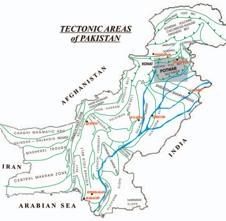
Geological and geophysical data from the offshore and onshore sedimentary basins of Pakistan indicates that favorable conditions for the generation and accumulation of hydrocarbons exist very widely.Oil discoveries are increasing tremendously yearby-year in the northern part of Pakistan as are gas discoveries in the south.Two hydrocarbonenriched basins of Pakistan are the Indus and Baluchistan,joined by the Axial Suture Belt and the Ornach Fault Zone (Figure 1).Most of the exploration work that has been done and is still ongoing has been in the Indus Basin,while the Baluchistan Basin - even with its better hydrocarbon and mineral exploration potential - has not been studied in depth.Both basins have a number of features characteristic for the generation and accumulation of oil and gas,e.g.,presence of source sediments,porous formations that provide suitable reservoir for hydrocarbons,and cap rocks.Moreover,many structural and stratigraphic traps also exist in both basins.Although exploratory wells that have been drilled in both basins,the Indus Basin has been more profitable compared to the Baluchistan Basin.Since 1947,40 wells have been drilled in the Baluchistan Basin;however,
the most recent five-year plan drilling results have shown little improvement due to political and cultural issues in the country.
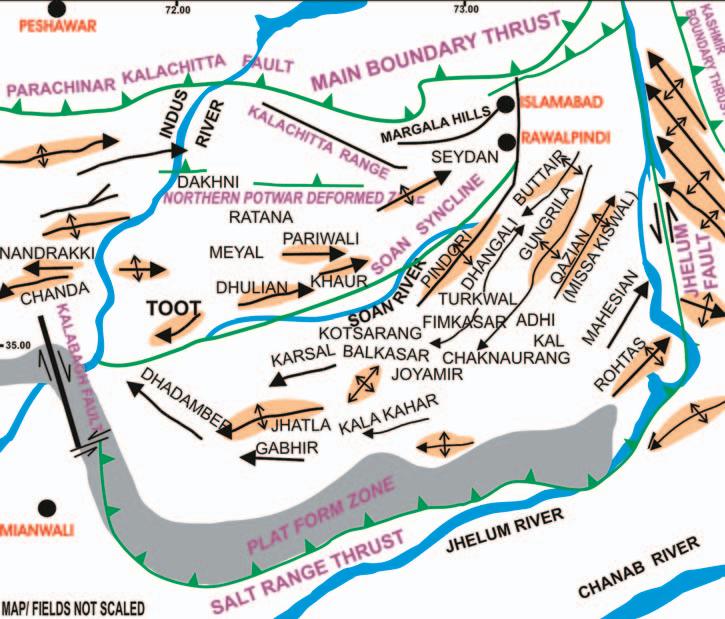
The northern area contains two major plateaus that play a role in the formation of the sedimentary basins,namely the Potwar and Kohat Plateaus (Figure 2).Oil and gas seeps,which help guide exploration,occur over a wide geological age range and hydrocarbon shows have been reported in numerous formations in the drilled wells.
The Kohat-Potwar plateau on the southern part of the Himalayan and Karakorum orogenic belt is a result of compressional tectonics resulting from ongoing collision of the Indian and Eurasian plates.The KohatPotwar plateau is bounded on the north by the Kalachitta Hills (Figure 1).The Salt Range and Trans-Indus ranges mark the boundary to the south,while the western boundary is limited by the Kurram-Parachinar ranges.The Kohat and Potwar are separated by the Indus River.To the east is the Potwar area and to the west is the Kohat area.Geographically, the Potwar plateau is situated approximately
BY WASIN PARACHA
between latitude 32°and 35°N and longitude 72°and 75°E (Figure 2).Hydrocarbon exploration in the Himalayan foreland (Salt Range/Potwar Plateau) of North Pakistan has provided new surface/subsurface data and information on the tectonic evolution of the overthrust belt.The Potwar is composed of gently dipping,imbricate wrench faults,which become steeper in the Kohat area (Paracha et.al,2000).The collision of the Indian and Eurasian plates is characterized by continentcontinent collision,obduction,and thrusting in the northern area,and is considered to be of the prototype Alpine-Himalayan orogeny (Farah et al.,1984).
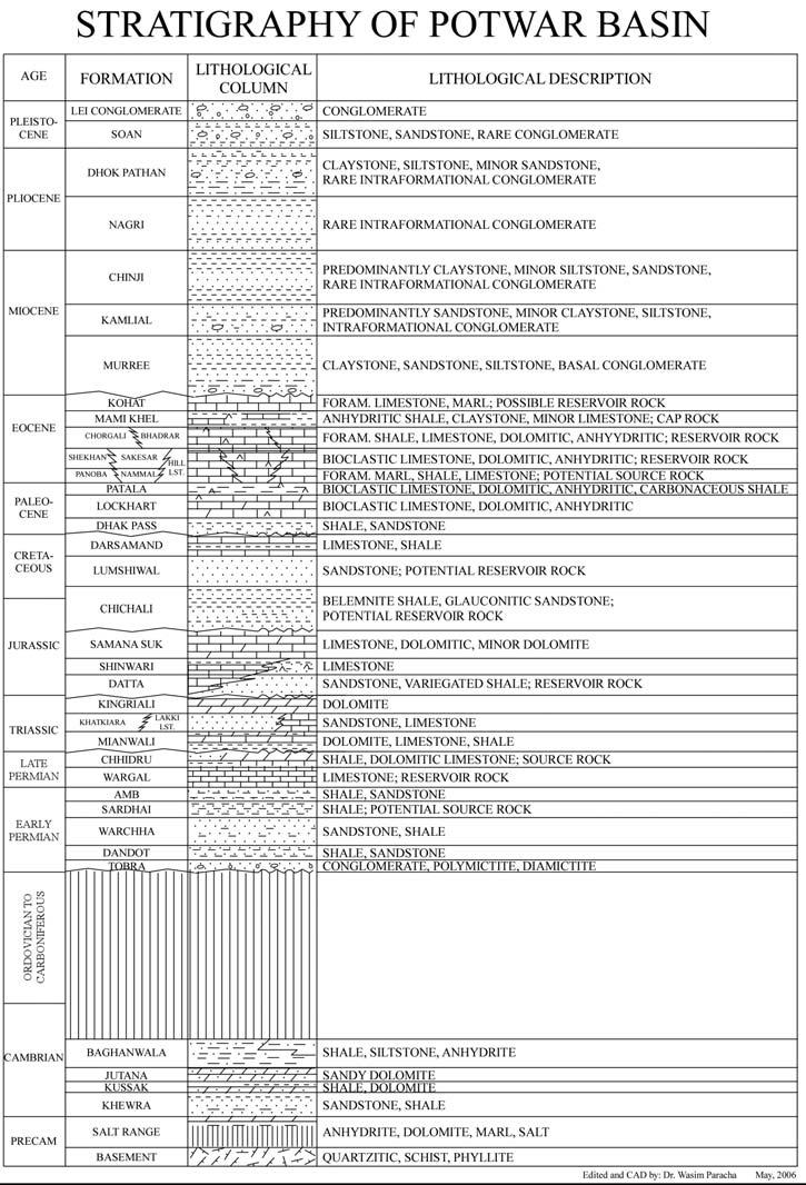
The area falls into the fairly common Geotectonic classification (Riva,1983). However,the area is still largely a frontier prospect for hydrocarbon exploration as it has not seen much exploration and drilling activity.Commercial production of oil and gas has been mainly confined to carbonate reservoirs of Eocene and Paleocene age and sandstone reservoirs of Miocene, Cretaceous,Jurassic,and Cambrian ages (Figure 3).
Paleocene-Eocene carbonate rocks (mostly limestone) are considered to be the primary stratigraphic objectives,both in regards to source rock potential and in providing thick porous rocks that could serve as reservoirs. These rocks contain the most significant horizons in the gas fields of the Lower Indus Basin and Potwar oil fields.Eocene rocks are also primary objectives in the Makran and Chagai areas,as well as in the offshore areas of Makran and Sind.
The Jurassic rocks are mostly limestone in the Kirthar and Sulaiman ranges and are sandier in the platform area of the Indian Shield and Potwar regions.The few wells in the Indus Basin that have penetrated the Jurassic show good reservoir characteristics. Jurassic rocks have proved to be oil-bearing in the Potwar area.
The Cretaceous rocks,which are mostly sandstones,have been shown to have great potential as reservoir rocks.With their anticlinal and faulted nature,it is reasonable to expect more traps in the Potwar and Lower Indus areas.
Cambrian rocks have not been penetrated in any well in the Lower Indus Basin,but have proved to be good reservoir rock in the Potwar and Punjab Plain areas.There,the
(Continued on page 34...)
Figure 1.General tectonic areas of Pakistan showing structural lineaments with study area (gray colored). (Edited by Dr.Wasim Paracha 2006).Map not to scale.
Cambrian sandstones are penetrated by a number of wells,with commercial production coming out of wells in the Adhi area.
The main Miocene target in the Potwar region is the fluvial Murree Sandstone.The Murree is not a particularly good reservoir, although oil has been found in one or two wells as a result of secondary migration from Eocene rocks.This migration was facilitated by the large fractures present in the Murree Sandstone.In the Lower Indus Basin,the Gaj Formation is the main Miocene zone of interest.The Gaj is predominately of marine origin.Although it is a sandstone unit with good porosity and permeability,results to date have been disappointing.However, exploration is continuing.
The Permo-Carboniferous marine limestone rocks are potentially good reservoir and source rocks.Although the hydrocarbon prospects in this age are low,several wells have reached this depth in the Lower and Upper Indus Basins.In those areas,they are more argillaceous but still have not been successful.
The Potwar lies in the northern part of Pakistan between 1,300ft-1,700ft above sea level.It is bounded by the Kala Chitta and Margala hills to the north,Salt Range to the south,Indus River to the west,and Jhelum River to the east.The pay zones are mostly in fractured limestone of Eocene and older age. In some wells,migrated oil has been found in the Lower Miocene sand of the Murree Formation.
REGIONAL GEOLOGY:
The Kohat-Potwar plateau forms the northernmost element of the Indus basin and is bounded in the north by the Kalachitta fold belt through a system of faults.The Salt Range composite orocline forms the southern limit and the Kurram thrust fault marks its western limit.The Pezu wrench fault separates the Kohat depression from the Sulaiman fold belt.
The axis of the Indus Basin trends east-west within the Kohat-Potwar depression and roughly follows the Soan River Drainage (M. A.Khan,Riaz Ahmed,Hilal A.Raza,and Arif Kemal,1986).The Northern Potwar deformed zone (Figure 2) shows a buried thrust front with a triangle zone and rampand-flat structures.The triangle zone is characterized by a core wedge of an irregular geometry,bounded between a floor thrust in the Eocambrian evaporite and a roof thrust in the Rawalpindi Group strata. The core wedge is bounded by the Soan back thrust and the exposed “S”-shaped
Khairi-Murat thrust (Figure 2).The KhairiMurat thrust soles out in the main decollement and is overlain by a planeroofed duplex horst over the hanging wall of the former structure.Both the Khairi-Murat thrust and the duplex are deformed by outof-sequence thrusting.The duplex geometry and out-of-sequence thrusting is responsible for the absence of the Siwalik strata and complex deformation north of the KhairiMurat thrust.
The Tertiary basin that developed between the colliding Indian and Asian plates began as a Foredeep,and then evolved to become a restricted evaporite basin,an early terrestrial foreland basin,an open marine basin,and finally a fully developed terrestrial foreland basin that was deformed in the Pliocene Pleistocene (Pivnik and Wells,1996).
The surficial structural geology is dominated by east-west trending anticlines having both limbs overturned and with steep down plunge ends.The anticlines are separated by broad synclinal valleys in which Neogene fluvial foreland basin deposits crop out (Sercombe,1998).
GENERAL PETROLEUM EXPLORATION
PROSPECTS DISTRIBUTION
Broadly,there are two major divisions in the Indus Basin:
1) Oil region (Potwar Plateau)
2) Gas region (Lower Indus Basin)
All the small oilfields in the Potwar Plateau lie south of the Islamabad area.Within the Potwar region,folding is least intense and monoclinal to the southwest.Northward,the folding becomes stronger and the structure becomes more complex,as in the Kala Chitta hills.The folds and structures become tighter and more complex east of the Jhelum reentrant and Pir Punjal areas.
The Potwar Plateau is divided by the Soan River or Soan Syncline.North of the Soan Syncline,lie oilfields like Dhulian,Khaur,Tut, and Meyal,while the southern area has the Karsal,Joya Mair,Balkassar,and Adhi (Figure 2).In this oilfield region,the principal formations are the Murree and Siwaliks. These formations are fluvial deposits having great thickness.The reservoir rocks of these oilfields are the Murree sandstone,Chorgali Formation,Sakesar Limestone,Lockhart Formation,Datta Formation,and Khewra Sandstone.
In the gas-prone Lower Indus Basin,the bedrock is covered by alluvium.Towards the platform area,the rocks become sandy and shaly with simple structural features while rocks in Kirthar and Sulaiman provinces are more complex.
Further divisions of Indus Basin have been made as follows:
1) KIRTHAR TROUGH region - contains
Figure 2.Potwar area with geological structural potential oil and/or gas fields.Map/fields are not to scale. Edited by Dr.Wasim Paracha 2006.
Sari Singh,Hundi,and Kothar gas fields with the Ranikot Limestone of Paleocene age as reservoir rock.Sari and Hundi are producing while Kothar is shut-in.
2) MARI-BUGTI HIGH region - contains Sui,Zin,Uch,Pirkoh,and Kotrum gas fields. All have the Lower Eocene Laki Formation as reservoir rock (also known as the Sulaiman Limestone).Pirkoh field lies in the Sulaiman Foredeep area.Only the Sui field is in production.
3) MARI-KHANDKHOT HIGH regioncontains Mari and Khandkhot gas fields. Mari field has Upper-Middle Eocene rocks
of the Habib Rahi Sandstone as reservoir rock and is still in production,while Khandkhot has Early Eocene Sui Main Limestone as its reservoir.
4) JACOBABAD HIGH region - contains Khairpur gas field with Sui Main Limestone as reservoir rock and is shut-in.
5) KIRTHAR FOREDEEP/FOOTHILLS - contains Mazarani gas field with Sui Main Limestone as reservoir rock.
6) BADIN region - contains Khaskheli oilfield in the Cretaceous Goru Sandstone and still in production.
Over much of the Potwar area,the freshwater post-Eocene Nimadric Sands, particularly in the Kamlial and Murree, contain high pressure,water-bearing sediments,which create drilling difficulties. Their pronounced lenticularity and lateral lithological variations make it difficult to identify or correlate these sands,even over short distances between wells within the same structures.
HYDROCARBON POTENTIAL:
The Indus basin,including the Kohat-Potwar depression,belongs to the category of extracontinental downward basin,which account for 48% of the world's known petroleum (Riva,1983).
The Kohat-Potwar depression has several features that make it a favorable site for hydrocarbon accumulations.Located on a continental margin,the depression is filled with thick deposits of sedimentary rocks, including potential source,reservoir,and cap rock (Figure 3).It contains a thick overburden (about 3,000m of fluvial sediments,which provides the needed burial depth and optimum geothermal gradient.Hydrocarbon seeps found in this area also demonstrate the area's potential (Khan,1986).
Only structural traps have been identified to date.However,the pinch-out and truncation of several formations,as well as known unconformities suggest that there may be stratigraphic traps in the region.Simple and translated fault-propagation folds form important structural traps in the fold and thrust belts.The most important traps in the fault propagation folds are in the crests of major anticlines.Fault traps may be present along back limb thrusts,between imbricates on the fore limbs,and in upturned beds in the footwall.Secondary traps may also be present within major thrust sheet, particularly at the leading edge of the thrust sheet and above footwall ramps (Shankar Mitra,1990).
SOURCE ROCK:
The uppermost formation of Paleocene age in the Kohat-Potwar depression is the Patala Formation.This formation is of extreme importance as the Patala shale is considered to be the main source rock for oil and gas produced in the basin.The Northern part of Potwar has been proven to be the main producing region for oil and gas in the area.
REFERENCES
Farah,A.,Lawrence,R.D.,and DeJong,K.A., 1984:An overview of the tectonics of Pakistan. In:Haq,B.U.and Milliman,J.D.(Eds.) Marine Geology and Oceanography of Arabian Sea and Figure 3.Stratigraphic column of Potwar and Kohat area. (Continued on page 37...)
SQUASH TOURNAMENT
This year’s tournament will be played at the WORLD HEALTH EDGEMONT CLUB, 7222 Edgemont Blvd. N.W., Calgary, on Februar y 8 - 10, 2007. The emphasis is always on having fun, but there is keen competition for the serious players. In past years, we have had beginners through to provincially ranked players in both the men’s and women’s divisions. We expect the same this year, so there is sure to be a level of play suited to you. Please register now while you are thinking of it!
PLEASE NOTE: THIS YEAR THERE WILL BE A MAXIMUM OF 125 PLAYERS, SO GET YOUR ENTRY IN EARLY TO AVOID DISAPPOINTMENT!
EVENTS: Men’s & Women’s A, B, C, D, and Novice.
Open only to members of the C.S.P.G. (or an affiliated society) and their spouse or equivalent. ENTRY FEE: Members: $50.00 includes GST, Non-members: $75.00 includes GST ($50.00 Students sponsored by Encana)
• Fee includes two guaranteed matches (Saturday teams tourney), shirt, refreshme
night dinner (Please specify Meat (M) or Veggie (V)), and draw prizes. Saturday’s dinner will be held at the Edgemont Club.
• Pre-tournament drop-in squash at Bow Valley Racquet Club (2nd Street and 5th Avenue S.W.) on Wednesday, January 24th and 31st from 6pm to 9pm, sponsored by Tucker Wireline Services.
• Pre-tournament registration social will be at Bow Valley Racquet Club on Tuesday, February 6th at 5:00pm. Pick up your tournament kit and first draw time, and enjoy a free pint of Ale with munchies, sponsored by Tucker Wireline Services.
• All door prize draws Saturday evening - must be present to win.
• Extra Dinner Ticket: $35.00 for non-playing guests only. (Will be limited to 15 due to venue space; first-come, first-served.)
ENTRY DEADLINE:
January 19, 2007. EARLY BIRD DRAW PRIZE for entries received prior to January 5, 2007. (No refunds after January 19,2007) FOR FURTHER DETAILS CONTACT: Colin Thiesse n 650-0086; Jessie Mitton 850-3578; Alan Ruther ford 861-2643; Chris May 645-5193; Randy S mith 263-0449; Jole ne Wood 243-0820; Ryan Bar nett 781-1712; Travis Brookson 261-9290; Kris Jewett 645-3827; Warre n D ublonko 232-1715; Mark Dzikowski 645-2851.
REGISTRATION FORM:
NAME: ❑ M ❑ F Email: ❑ CSPG ❑ CSEG ❑ Other : ___________________ Comp
requency of Play: _______ (A-E) Banquet Dinner (As described above): ❑ M ❑ V MEMBER FEE: $50.00__________ NON-MEMBER FEE: $75.00__________
PLAYING SPOUSE NAME: ____________________________________________
requency of Play (A-E): ________ Banquet Dinner (As described above): ❑ M ❑ V SPOUSE FEE: $50.00__________ WILL YOU ATTEND THE DINNER: ❑ YES ❑ NO
ADDITIONAL DINNER TICKET: ❑ YES ❑ NO FEE:
(for non-playing guest Max 15 spots available; first-come, first-served) TOTAL FEES REMITTED: $___
NOTE: Games commence Thursday, February 8, 2007. All participants must be available to play after 4:30pm Thursday, Friday afternoon, and all day Saturday.
ADDRESS REGISTRATION TO: Hycal Energ y Research Laboratories Ltd. 1338A 36 Ave. NE Calgary, AB T2E 6T6
Please make cheques payable to the Canadian Society of Petroleum Geologists Attn: Squash Tournament (no cash) No refunds after January 19, 2007.
Coastal Pakistan.Von Nostrand Reinhold Co., New York,pp.161-176.
Jadoon,I.,A.,Kemal,A.,Frisch,W.,and Jaswal,T., 1997:Thrust geometries and kinematics in the Himalayan Foreland (North Potwar Deformed Zone),North Pakistan.Geologische Rundshau, Germany.Vol.86,No.1;Springer Berlin / Heidelberg.,New York,pp.120-131.
Khan,M.A.,Ahmed,R.,Raza,H.A.,and Kemal, A.,1986:Geology of petroleum in Kohat-Potwar depression,Pakistan.AAPG Bulletin,Vol.70,pp. 396-414.
Paracha,W.,Kemal,A.,Abbasi,F.,2000:Kohat Duplex in Northern Potwar Deformed Zone, Pakistan.Geol.Surv.Of Pakistan,Geologica,Vol. 5,pp.99-107.
Pivnik,D.A.and Wells,N.A.1996:The transition from Tethys to the Himalaya as recorded in northwest Pakistan.Geological Society of America Bulletin,Vol.108,pp.1295-1313.
Riva,J.P.Jr.,1983:World petroleum resources and reserves.Boulder,Colorado,Westview Press, 355p.
Sercombe,W.J.,Pivnik,D.A.,Wilson,W.P., Albertin,L.M.,Beck,R.A.,Stratton,M.A.,1998: Wrench faulting in the northern Pakistan foreland.AAPG Bulletin,Vol.82,No.11,pp. 2003-2030.
BIOGRAPHY
Wasim Paracha (Ph.D.from Sweden,1998) is an Exploration Geophysicist with over ten years of professional experience in CBM,basin analysis,prospect generation,and structural studies in Central Alberta (Swan Hills,Judy Creek with Trident Exploration),WCSB, Canadian Arctic,North Sea,and the Himalayas.
In addition to working as an explorationist and teaching at SAIT,Wasim is an expert in seismic sequence stratigraphy with 3D/2D modeling, depth imaging studies,AVO,reservoir evaluation, and well log analysis and has published 25 articles and reports.He can be reached at drwasimparacha@shaw.ca or 403-273-4395.
1) Mississippian Subcrops and Devonian Reef Edges - AB, NE BC, NT and SK 2) Triassic Halfway, Doig, Charlie Lake - Peace River
3)
4)
6)
8)
library, printing, digitizing or evaluation
- Open standard for any software
- Integration with NeuraLog for automated digitizing and NeuraSection for rapid geologic evaluation
- High speed log copies with the NeuraLaser
UNCERTAINTY ASSESSMENT IN 3D RESERVOIR MODELING
BY EMMANUEL GRINGARTEN, EARTH DECISION SCIENCES
AN INTEGRATED APPROACH
Uncertainty is not an inherent feature of our reservoirs;it is due to our lack of knowledge and understanding about the reservoir.Uncertainty can be modeled,but there is no objective measure of uncertainty. The uncertainty will be as large as the modeler decides to make it.Therefore,one must be open-minded… very open-minded. This introduces us to a new modeling paradigm:it is necessary to think in terms of what we don't know,rather than in terms of what we know.This paradigm shift associated with the right tools provides for better decisions,faster.
MANAGING UNCERTAINTY
We believe that in order to appropriately manage uncertainty linked to various aspects of reservoir management,we need a method and a tool that satisfies the following requirements:
1) To be able to evaluate the complete range of uncertainties.It is then necessary to be able to capture them,i.e.,to quantify and store different structural scenarios and/or geological models.Last,all of it must be integrated in a consistent framework to automatically quantify their cumulative impact.
2) One must be able to identify the relevant elements of uncertainty and filter out those that don't matter.
3) Finally,once key uncertainty elements have been identified,it is necessary to rapidly know what actions are required to reduce their uncertainty to an acceptable level.For a reservoir modeling point of view,that would mean:(i) refining the interpretation,(ii) refining the model, or (iii) gathering more data because interpretation and modeling uncertainty cannot be refined any further with existing information.
UNCERTAINTY AND 3D RESERVOIR
MODELING
Understanding 3D uncertainties
With today's software,constructing a 3D geological model of the reservoir is relatively simple.Once a model is constructed,it should be easy and automatic to construct multiple versions (either by simply changing a parameter and / or performing stochastic simulation,etc.) We will postulate that constructing multiple 3D models is the only way to assess the cumulative impact of data,interpretation, and modeling uncertainties on reservoir management decisions.
3D Uncertainty Analysis
A typical 3D uncertainty analysis workflow is as follows:(i) evaluate the uncertainties –taking each step of the workflow along with all the parameters involved,one must quantify how much is unknown about each one of them;(ii) integrate the uncertainties – through the construction of a complete reservoir model;(iii) analyze the impact of constructing multiple models on the metrics used to make a decision;and (iv) iterate to reduce the uncertainties until the risks are minimized sufficiently to allow decision making.
3D Modeling Workflow
A 3D reservoir model consists of the following elements:(1) a structural model consisting of horizons and faults,(2) fluid contacts – gas-oil (GOC) and oil-water (OWC),(3) a sedimentological model (optional),(4) a porosity model,(5) a permeability model,(6) a net-to-gross (NTG) model (which may or may not be related to the sedimentology),(7) a water saturation model (highly dependent on everything listed above),(8) a PVT model describing formation volume factors and solution gas ratios,etc.and,(9) a reservoir simulation model.
Each of these elements has its own way of being quantitatively described,and uncertainty measures may also be different for each.However,it is important to think of
them as interconnected members of a single entity.They are highly dependent on one another (e.g.,water saturation can be a function of height above contact – itself dependent on the position of the reservoir structure and the contacts,and the porosity and permeability models).Furthermore, there exists a hierarchy in the way they fit together to form a 3D reservoir model giving rise to the concept of “nesting” which we will come back to later.
Model Uncertainty
Typically,model uncertainty is seen as multiple realizations of a geostatistic-based process.Stochastic simulations will reproduce input parameters “on average,” and that is done by construction! Variability in responses from geostatistical simulation is simply due to what is known as ergodicity –stochastic fluctuations around the input parameters.
The uncertainty related to model parameters is one that is very rarely dealt with in practice,yet it may be one of paramount influence on the global uncertainty.What is essential is to model “what we do not know”,i.e.,what are the exact values of the modeling parameters.
Multiple Realizations
The only way to assess the cumulative impact of all uncertainties is to construct
(Continued on page 40...)
(A)
(C)
(B)
Figure 1.Summary of multiple realizations of a 3D reservoir model:(A) History plot,(B) Histograph,(C) CDF.
multiple realizations through a combination of scenario-based and stochastic simulations.As mentioned above,once a model is constructed,i.e.,a workflow is put in place that fits all the pieces together, changing a piece or part of a piece should be automatic and require no extra effort from the modeler.With today's computer architecture and processing power,this is quickly becoming a non-issue.It is relatively fast to generate a static model,even if it contains millions of cells,to generate a hundred can be done over lunch,and a thousand over night!
Summarizing Multiple Realizations
For volumetric computations,different types of volumes that can be computed are:the gross rock volume (GRV),the net rock volume (NRV),the net porous volume (NPV),the different fluid volumes (OIP and GIP),and the connected volumes using various connectivity criteria.These volumes should be reported not only for the whole model but also for any regions defined on the model,i.e.,concessions or lease boundaries,fault-blocks,reservoirs,zones, facies,and the intersections of the lot. When a model includes reserves estimations and fluid flow simulation,one should also consider looking at produced volumes,recovery factors,water-cuts,and GORs – per well,per platform,per field. These are the “metrics” of the model allowing its classification.Figure 1 illustrates the kind of display one should look at:it includes three important panels:(a) the first one displays for each model realization,a summary volume – this is referred to as a History Plot;(b) the second one shows the global histogram of that same information along with the appropriate summary statistics,and (c) the third panel shows the cumulative distribution (CDF).
All that is described above and illustrated in Figure 3 give us our first decision-support tool.This tool:
(a) yields a list of realistic outcomes that can be used as input distributions for Monte-Carlo-based economics analysis,
(b) clearly summarizes the uncertainty in reserve estimates and shows if a sufficient number of models have been generated, and
(c) allows us to understand the spread in outcomes and the values of important percentiles.
As the result of an economic risk analysis may require that the global spread of the assessed uncertainty be reduced,it is necessary to identify which factors would benefit from more rigorous attention.
IDENTIFYING KEY UNCERTAINTIES
One must be able to quickly identify the key uncertainties,i.e.,not necessarily the ones that have the largest spread,but the ones whose uncertainty have the biggest impact on the reservoir management decision at hand.The metrics defined above are the link between the estimates and the decision. From them,the impact of each element is deduced.
As a simple illustrating example,let's consider the equation for Oil in Place at reservoir conditions (no gas):
Equation 1
OIP = GRV * NTG * ø * (1 - Sw)
The major elements here are the gross rock volume (GRV),consisting of a structural piece:horizons and faults – properly connected together – and fluid contacts;the
Figure 2b.Hierarchical nesting in reservoir modeling.
Figure 2a.Independent Simulations
Figure 3:Nested simulations history plots illustrating that,in this particular example,structural uncertainty has a larger impact on OIP estimates than porosity or water saturation (no NTG specified).
net-to-gross (NTG);the net porosity (ø), and the water saturation (Sw).
Identifying which of these elements is more important than the others will help focus resources on relevant issues,stay at the right level of technical detail,and in turn save time and money.
Nested Simulations
In terms of 3D modeling GRV,NTG, ø,and Sw have a natural “nesting”,or hierarchical ordering:the GRV represents the envelope of the reservoir,only part of it defined by the NTG represents an acceptable type of rock; ø is the void space in which if there is no water (Sw),there is hydrocarbon.The same order is followed when creating a 3D reservoir model and a hierarchical dependency is therefore created.
There are two types of approaches when running multiple realizations,which we will refer to as Independent simulations and Nested simulations.
Independent simulations correspond to drawing one outcome of each element, reporting the volumes (or any summary metrics),and starting again at the very top of the hierarchy and taking a new reservoir structure as to represent the GRV,then a new NTG realization,then a new ø realization,and finally a new Sw realization. In a more complete reservoir model,the hierarchy is illustrated in Figure 2a. Performing Nested simulations implies drawing multiple sub-elements for each
major element and so on.Nested simulations are illustrated in Figure 2b.For example,for each reservoir structure,one can consider,say 5 NTG;for each NTG: 5 porosities;and for each porosity:5 water saturations.The total number of complete 3D models for each sample structure in this particular example is 125 (5 * 5 * 5).The total number of realizations becomes very large,but it very quickly shows also which element has the largest impact.This is very important at an early investigation stage when the 3D model does not need and should not be unnecessarily fine,and it is therefore possible to generate quickly a large number of realizations as shown in Figure 3.
Tornado Charts
Tornado charts are great to visually summarize information and more precisely identify the impact of various plotted parameters.They are excellent decisionsupport tools for that reason.
If we consider the equation for Oil in Place (see Equation 1),and multiple “Independent” realizations,it is possible to simply de-couple the influence of each element on the total variability of the system by considering the P50 value of each element and by modifying one at the time to see the positive or negative impact of the P10 and P90 values.The previous example would yield the tornado chart of Figure 4,where it is confirmed that structural uncertainty has the largest impact on OIP.
Decision Making in the Face of Uncertainty
Now that we have generated hundreds or even thousands of models,how do we make a decision?
There are three major aspects to decisionmaking in 3D uncertainty modeling.The first one is to rank the alternative reservoir models and perform more in-depth analysis of extreme and “average” models.The second is to be able to optimize the decision (such as the positioning of a development well) given all the possible representations of the reservoir.The last is to use the resulting distributions as input to a more complete chain of Monte Carlo simulations which captures elements beyond earth sciences (facilities,transports,oil price,etc).
RANKING
Generating many models is one thing,but analyzing each one of them is another and is near impossible.It is therefore necessary to be able to select representative models for a more in-depth analysis and understanding of the possible dynamic responses of the reservoirs.However,the rank of a particular model is,of course,dependent on the criteria or metric chosen to perform the ranking. This means that a model is representative to serve as a basis of a given decision only if the ranking criterion is representative of the decision that needs to be made.The CDF of Figure 1 represents the ranking of all models given the displayed criteria,e.g.,the highlighted realization (# 95) is a P90 with respect to the original Oil in Place.
CONCLUSIONS
• Modeling uncertainty is a complex issue that can not be solved using simplistic scripts of algorithms that use a subset of the data available.Instead,tools that can integrate all data and test their effect (or lack of effect) on the model must be used.
• Uncertainty is the concern of an integrated asset team.Their integrated 3D model is the repository of all their knowledge,but also their lack of it,i.e.,the uncertainties.It also shows the imbrications and interdependencies of all modeling stages.A software tool must exist that enables this to happen,for example JACTA has been able to seamlessly capture and integrate structural,reservoir,and flow uncertainty.
• Uncertainty evaluation,capture,and integration must be done throughout the life of the reservoir.The tool must be flexible enough to allow scalability and fitfor-purpose analysis.There must be a consistency between quick Monte-Carlo-
(Continued on
based volumetric estimates – which do not need to have millions of cells – and 3D geological models.
• Input parameters have a high degree of uncertainty because they are inferred from sparse,unreliable,biased interpreted data. It is fundamental to be able to capture and use all of it.
• Geological modeling software must be tightly integrated with dynamic flow simulators to allow a more reliable ranking of the multiple realization of the reservoir. It is also an ideal way to investigate and optimize alternative field development strategies
• Geological modeling software need to be tightly integrated with economic evaluation tools to directly measure the impact of various uncertainties associated with the different elements of the subsurface model.
• Uncertainty is a constitutive part of the Shared Earth Model;every element has an uncertainty associated to it.
BOOK STORE ORDER FORM
(13 or 16 numbers) ■ Mastercard (16 numbers) Card number:____________________________________________
Figure 4.Tornado Chart resulting from the example in Figure 3 (no NTG specified).
CSPG BOOKSTORE – NEW TITLES! NOW AVAILABLE!
Field Geology
Illustrated
Field Geology
Illustrated is a reliable,in-depth field reference for professional geologists,serious amateur geologists, and other environmental scientists. This entirely new second edition represents the first detailed,comprehensive book on field geology in 20 years.Richly illustrated with 688 high-quality photographs and 300 interpretative sketches,this 704-page book is printed on glossy paper to show important structural and textural features. Contents include marine geological surveys, plutonic rocks,volcanic rocks,continental deposits,marine deposits,deformed rocks (joints,faults,folds,cleavage) weathering processes and soils,ground water,mineral deposits,and the public land survey system.
Terry S.Maley,Soft Cover,2005,704 pages, Code Con 26
CSPG MEMBERS - $28.88
List Price - $38.50
Shipping in Canada - $7.50
Shipping to the U.S. - $10.00
At Risk:Earthquakes and Tsunamis on the West Coast
societal and individual measures that can be taken to reduce the damage and loss of life from earthquakes and tsunamis.
John Clague,Chris Yorath,Richard Franklin,and Bob Turner,Soft Cover,2006,200 pages,ISBN 0969760175,Code Con 27
CSPG MEMBERS - $22.46
List Price - $29.95
Shipping in Canada - $7.50
Shipping to the U.S. - $10.00
Climate Change and Landscape in the Canadian Rocky Mountains
Climate change is a prominent issue today.Its physical effects together with political initiatives to ameliorate humaninduced climate change will affect the social and economic lives of us all.This book explains the science on which climate interpretations are based.It describes the global and local sources of paleoclimate information,how climate changes are dated,and how this information is used to reconstruct the Ice Age climate history of the Canadian Rockies over the last 30,000 years.
Nat Rutter,Murray Coppold and Dean Rokosh, 2006,The Burgess Shale Geoscience Foundation, Soft Cover,137 pages,colour illustrations, ISBN 0-9780132-1-2,Code Con 25
CSPG MEMBERS - $15.49
List Price - $20.65
Shipping in Canada - $7.50
Shipping to the U.S. - $10.00
The World According to Rock Great for Kids!
A series of water-colour illustrations with free verse text tells the reader about many common rock types. The text describes Earth processes that form and reform different rocks.The reader will explore how useful rocks have been in our everyday life –providing building and art materials,giving us seasoning for the table,fuelling energy plants, offering beautiful scenery,locating survey points,and proving playgrounds.In this book you will write on,dive off,throw,skip,kick,and collect rocks.A photographic index provides rock definitions.
Jerry Wermund,illustrated by Tony Sansevero, 2004,Hard Cover,48 pages,colour illustrations, ISBN 0972625518,Code Con 23
CSPG MEMBERS - $15.49
List Price - $20.65
Shipping in Canada - $7.50
Shipping to the U.S. - $10.00
This book is the story of the powerful earth forces at work in the western and off-shore areas of British Columbia, Washington,and Oregon,with special emphasis on earthquakes and tsunamis and how they threaten the people who live there.It offers timely and important information for these people and for anyone interested in the interplay between the forces of nature and cities.It provides information on why there are earthquakes and why they are common on the west coast of North America.It describes the giant earthquakes that will likely occur off the coast and the tsunamis that they may trigger.It also describes the destructive earthquakes that could take place on faults close to Vancouver,Victoria,Seattle,and Portland.It provides information on the many effects of earthquakes,including ground shaking,landslides,and liquefaction,and
CSPG MEMBERS - $13.46
List Price - $17.95
Shipping in Canada - $7.50
Shipping to the U.S. - $10.00
Earthscapes:Landforms
Sculpted by Water,Wind and Ice Great for Kids!
A series of photographs accompanied by poems let the reader explore varied land forms in the United States,Alaska, Arizona,Colorado,Florida,New York,Texas, Wisconsin,and Wyoming.The reader explores land forms from Algeria,Mali,Mauritania and Spain.The texts give the reader a description of the land forms and explains how they are made by natural processes,compared to human imprints on the Earth's surface.
Jerry Wermund,2003,Hard Cover,48 pages, colour illustrations,ISBN 097262550X, Code Con 24
• reminders of CSPG events including Technical Luncheons,social events and the annual convention
• listings of various Geoscience Community events throughout Canada and the U.S.
• 12 gorgeous,full-page photos – all taken by CSPG members!
Code Cal 2007
CSPG MEMBERS - $7.50
List Price - $10.00
Shipping in Canada - $3.00
Shipping to the U.S. - $5.00
The CSPG also carries select titles from the AAPG,SEPM,AGI,GAC,and GSC.
For information on these and all our other publications,please visit www.cspg.org or come by the new office at 600,640 – 8th Avenue SW!
Maximum reservoir performance
Want to make the most of your valuable oil and gas reserves?
Roxar’s integrated technology solutions and services help companies of all sizes realize the full economic potential of their oil and gas resources.
• Innovative modeling and simulation software
• Downhole monitoring and control systems
• Reservoir production multiphase metering
• Reservoir and production consultancy
Roxar’s leading-edge technology solutions from reservoir interpretation through to production & process meet the changing needs of users in managing the entire reservoir lifecycle.