■ Are Recent Discoveries a Template for the Future?
■ Are Recent Discoveries a Template for the Future?
CSPG OFFICE
#600,640 - 8th Avenue SW
Calgary,Alberta,Canada T2P 1G7
Tel:403-264-5610 Fax:403-264-5898
Web:www.cspg.org
Office hours:Monday to Friday,8:30am to 4:00pm
Business Manager:Tim Howard
Email:tim.howard@cspg.org
Communications Manager:Jaimè Croft Larsen
Email:jaime.croftlarsen@cspg.org
Conventions Manager:Lori Humphrey-Clements
Email:lori.humphreyclements@cspg.org
Corporate Relations Manager:Kim MacLean
Email:kim.maclean@cspg.org
Membership Services:Sarah Barton
Email:sarah.barton@cspg.org
Reception/Administration:Tanya Santry
Email:tanya.santry@cspg.org
EDITORS/AUTHORS
Please submit RESERVOIR articles to the CSPG office.Submission deadline is the 23rd day of the month,two months prior to issue date. (e.g.,January 23 for the March issue).
To publish an article,the CSPG requires digital copies of the document.Text should be in Microsoft Word format and illustrations should be in TIFF format at 300 dpi.For additional information on manuscript preparation,refer to the Guidelines for Authors published in the CSPG Bulletin or contact the editor.
COORDINATING EDITOR & OPERATIONS
Jaimè Croft Larsen
CSPG
Tel:403-264-5610,Ext 227 Fax:403-264-5898
Email:jaime.croftlarsen@cspg.org
TECHNICAL EDITOR
Ben McKenzie
Tarheel Exploration
Tel:403-277-4496
Email:bjmck@telusplanet.net
ADVERTISING
Kim MacLean
Corporate Relations,CSPG
Tel:403-264-5610,Ext 229
Email:kim.maclean@cspg.org
Advertising inquiries should be directed to Kim MacLean.The deadline to reserve advertising space is the 23rd day of the month, two months prior to issue date.All advertising artwork should be sent directly to Kim MacLean.
The RESERVOIR is published 11 times per year by the Canadian Society of Petroleum Geologists. This includes a combined issue for the months of July/August.
Advertisements,as well as inserts,mailed with the publication are paid advertisements.No endorsement or sponsorship by the Canadian Society of Petroleum Geologists is implied.
The CSPG Rock Shop is an attractive and affordable way to target the CSPG readership. Spaces are sold at business card sizes (3.5” wide by 2” high).To reserve space or for more information,please contact Kim MacLean at 403-264-5610,ext.205.
The contents of this publication may not be reproduced either in part or in full without the consent of the publisher.
FRONT COVER
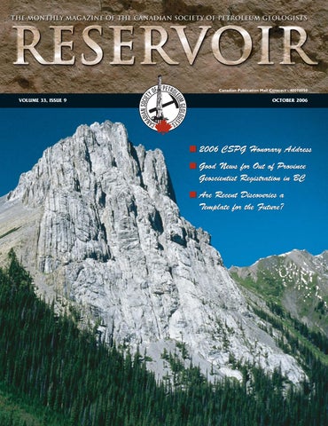
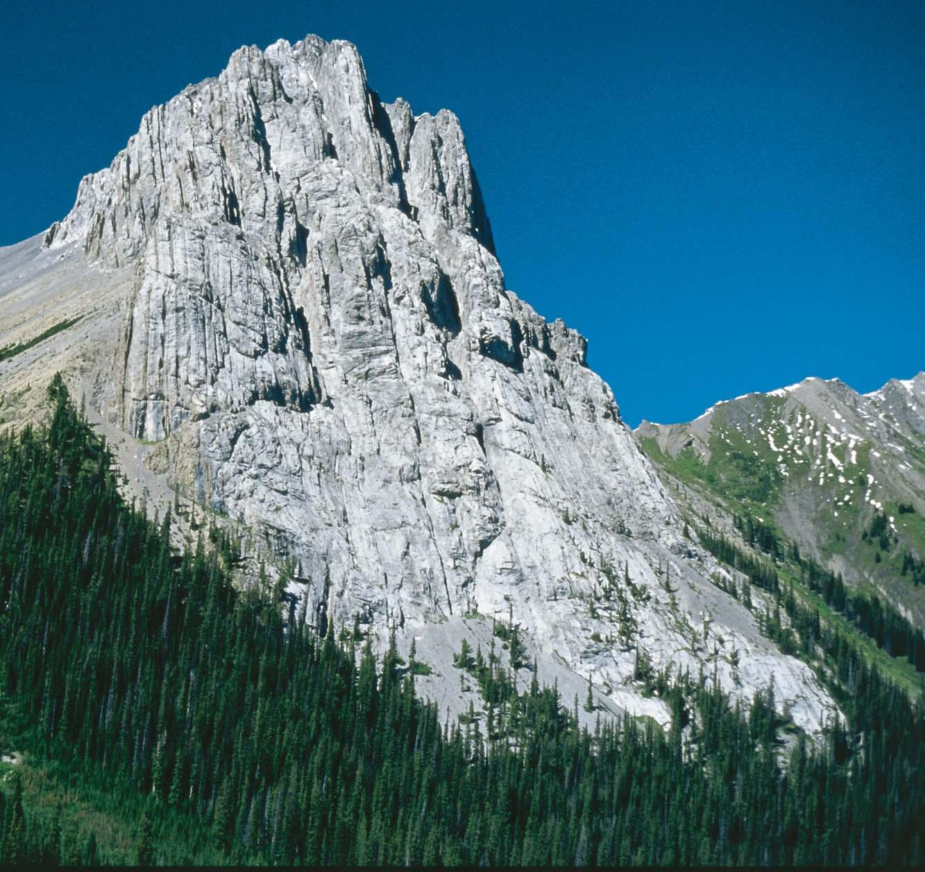
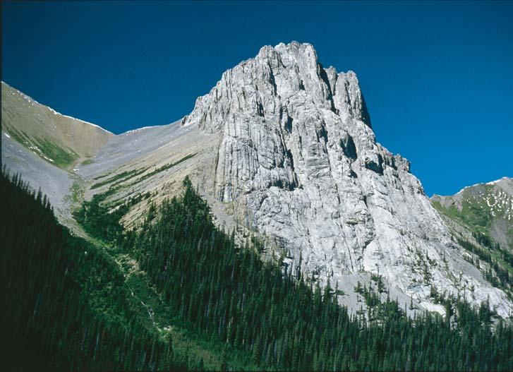
Peter Lougheed Provincial Park, Alberta. View looking north to Commonwealth Peak. Commonwealth Peak is formed by the steeply dipping, resistant, gray carbonates of the Upper Devonian Lower Palliser Formation that forms part of the east limb of an anticline. The brownish and more recessive arenaceous beds of the older Sassenach Formation lie below and to the west of the Palliser. Photo by Gordon Hurlburt.
Well,I'm nine months into my tenure as Assistant Services Director and I've had the opportunity to see how the society operates on just about every level.Perhaps the one thing that amazes and impresses me the most about the CSPG is how many volunteers it takes to effectively run a not-for-profit society such as ours.
For someone new to the society,or to some of our less active members,the office staff and the Executive are the face of the society,as is evident by our smiling mugs adorning this article every month.What most members don't see is the over 400 volunteers who work behind the scenes on over 50 active subcommittees (see www.cspg.org/about/ society-structure.cfm for a listing of committees).It is these people who do the bulk of the work and who make the society what it is – a model for every other technical society in Canada.One can liken it to the workings of a ship (naval analogy – sorry,old habits),the Captain plots the course and it's the crew that does the work to get them there.
Speaking of volunteering for the CSPG,here's an interesting fact that's been getting a lot of attention lately;“…approximately 50 to 75% of the industry's geoscientists are expected to retire over the next five to ten years”…a staggering figure to say the least! Over that five- to ten-year period,a very large part of the society's volunteer base will disappear with potentially disastrous consequences for the CSPG.By being proactive and introducing new members to the concept (and vital importance) of volunteerism,and by openly displaying its value to our membership,we can prevent any potential interruption to critical membership services or activities.
One of the best tools at the society's disposal is our Volunteer Management Committee.It is their mandate to “…provide members with meaningful volunteer opportunities within the Society and to reward them for their service.”
They help determine the needs of each committee,actively recruit volunteers and fill voids by matching these volunteers to specific committees by their skill set or interests.They are an invaluable asset to the CSPG and I would personally like to thank them for all their hard work and determination.Thank you Karen and Colin!
I first volunteered for the CSPG at the 1999 annual convention (thanks Douglas),and as a service award received a shiny CSPG belt buckle which is proudly displayed every year during Stampede.Three conventions later,and now as a member of the executive,I have to say it has been very rewarding for me.I have met some very good friends and without a doubt aided my career through contacts I've made over the years… networking really works in Calgary!!
Whether you're a new member looking for more insight into the industry or have been a member for years and are unsure of the direction of the society,then get involved, volunteer,and have a voice in the future path of the CSPG.You won't be disappointed.
The CSPG is always in need of enthusiastic, energetic men and women who are willing to donate their time to further the society's causes and programs.The society is literally nothing without our volunteers!
If you wish to volunteer or contribute to the CSPG,please contact Karen Webster or Colin Yeo of the Volunteer Management Committee at volunteer@cspg.org.
“Volunteers are not paid….not because they are worthless,but because they are priceless!” …Anonymous.
Who knows,maybe you could get a belt buckle of your own – after all,everyone needs one in Cowtown!
IHS + PETRA®…
depthsinnovationsresults visions that exceed all others. now.
CONTOURING
Faultedcontours
Isopachs
Volumetrics
Gridoperations
Newflexingoptions
CROSS SECTIONS
NewUnassignedTops
Digitaland/orRaster
Geocolumnshading
Stratigraphic/Structural
Shadebetweencrossover
Dipmeterdata
MAPPING OPTIONS
ExpandedGISFunctions
Bubblemaps
Productioncharts
Logcurves
Posteddata
HighlightedSymbols
3D VISUALIZATION
Deviatedwellbores
Digitallogs
Gridsurfaces
Tops,ShowsandPerfs
Landgridoverlay
Mapimages
DECLINE CURVES
ComputeEUR,RR,etc.
Hyperbolicorexp.
Rate/TimeorCumP/Z
UserdefinedEcon.Limit
User defined Extrap.Time
How our vision supports yours
PETRA: Pioneer of easy, affordable PC solutions for today’s workflows.
IHS: The industry’s leading choice of E&P data and delivery systems to populate PETRA projects. The combination: Fast, confident prospect analysis for you.
Download a trial version at www.ihs.com/energy/petra, or call us at 888-738-7265 for more information. And stay tuned for more on our vision of streamlined data flows for prospect studies.
THE CSPG GRATEFULLY ACKNOWLEDGES ITS CORPORATE MEMBERS:
THE CSPG GRATEFULLY ACKNOWLEDGES ITS CORPORATE MEMBERS:
ABU DHABI OIL CO., LTD. (JAPAN)
APACHE CANADA LTD.
BAKER ATLAS
BG CANADA EXPLORATION & PRODUCTION, INC.
BP CANADA ENERGY COMPANY
BURLINGTON RESOURCES CANADA LTD.
CANADIAN FOREST OIL LTD.
CONOCOPHILLIPS CANADA
CORE LABORATORIES CANADA LTD.
DEVON CANADA CORPORATION
DOMINION EXPLORATION CANADA LTD.
DUVERNAY OIL CORP.
geoLOGICsystems ltd.
GRIZZLY RESOURCES LTD.
HUNT OIL COMPANY OF CANADA, INC.
HUSKY ENERGY INC.
IHS
IMPERIAL OIL RESOURCES LIMITED
LARIO OIL & GAS COMPANY
MJ SYSTEMS
MURPHY OIL COMPANY LTD.
NCE RESOURCES GROUP INC.
NEXEN INC.
NORTHROCK RESOURCES LTD.
PENN WEST PETROLEUM LTD.
PETRO-CANADA OIL AND GAS
PETROCRAFT PRODUCTS LTD.
PRIMEWEST ENERGY TRUST
PROVIDENT ENERGY LTD.
RPS ENERGY
SHELL CANADA LIMITED
SPROULE ASSOCIATES LIMITED
STARPOINT ENERGY LTD.
SUNCOR ENERGY INC.
TALISMAN ENERGY INC.
TOTAL E&P CANADA LIMITED
WEATHERFORD CANADA
... AND NOW A WORD FOR OUR SPONSORS
Let me be honest and frank:the CSPG's Sponsors,Advertisers,and Exhibitors are here to make money for their shareholders.
The Society uses sponsorship funds to provide our members with enhanced programs and services far beyond what our dues would enable us to deliver.This is a mutually beneficial arrangement that is important to embrace if we are to continue to maintain and expand services to our members.
As practicing geologists,we need the products,services,and expertise of service companies to do our jobs accurately,quickly, and cost effectively.Although our knowledge of the basin has increased,the single biggest influence on productivity has been the advent of electronic geological and engineering databases,image rasterization, and geological computing applications.It is service companies that are providing the means and capabilities to becoming more efficient and effective.
Again,let's be honest.Service companies are in business to make money for their key stakeholders.Market share is paramount, and is dependent on brand recognition, product education to consumers,and feedback from customers.
A MESSAGE FROM CORPORATE RELATIONS
E&P companies want the Society to continue providing top technical conventions and conferences along with a strong continuing education component. Also,these companies want to be recognized as supporters of the Society as they recruit new employees and retain current staff.
Our sponsors ask only one thing in returnlisten to their message;talk to service company representatives and ask them about their service and products;walk the exhibition hall at the convention and learn about what they have to offer.They may have just the data or technique or insight that you need to do your job better,faster, and cheaper.
The Society could never provide the kind of programs and services we now do,at current dues level,without sponsorship support.Our annual convention,technical luncheons,volunteer recognition,technical divisions,university outreach,and social programs are but a few of the many programs and services supported by our sponsors.The Society needs and welcomes their support.Without them,the Society would be a poorer place,in more ways than just financially.
As a CSPG member who may benefit from a sponsor's contributions to the Society, please take a moment to acknowledge and thank our sponsors for their involvement when the opportunity arises.Let them know that you saw their ad at a technical luncheon,read about them in the Reservoir, saw their sponsorship contribution at a conference,or just say hi when you see them at a social function.
CORPORATE MEMBERS AS OF
AUGUST 24, 2006
The CSPG provides an opportunity for companies to target their primary audience through an integrated marketing program that uses a combination of direct marketing, trade shows,and print media to accomplish their brand awareness,positioning,and sales growth objectives.We are a very concentrated group of users,decision makers,and influence peddlers.They want a vibrant Society (marketplace) to continue to attract and concentrate potential customers and to create opportunities to partner with users that will build a loyal following.
Kim MacLean,our Corporate Relations Manager,works with service companies and other industry companies to align segments of the Society to meet their marketing objectives.Our key stakeholders are investing in the CSPG and are looking for their return on their investment.The Society is committed to providing value for their money and we thank Kim for continually being in the forefront of this constantly changing landscape.
Colin Yeo Vice President
Boyd PetroSearch helps you evaluate new territory.
Exploring? Boyd PetroSearch offers a comprehensive Project Management service to provide high quality, cost-effective options for seismic exploration. We manage every stage of your exploration program – from pre-planning through recording. Our experience in approvals, mapping, permitting and HSE is unbeatable.
Find out how we can reduce your risk in acquiring seismic data by ensuring that your projects are completed safely, on time and on budget.
Please call:
Kevin Bowman 403.543.5357
Kathy Sloan 403.543.5375
Dani MacLeod 403.543.5384 or visit www.boydpetro.com
TECHNICAL LUNCHEONS
OCTOBER LUNCHEON
Episodic global tectonics: sequence stratigraphy meets plate tectonics
SPEAKER
Ashton Embry Geological Survey of Canada
11:30 am Thursday,October 12,2006
TELUS CONVENTION CENTRE CALGARY, ALBERTA
Please note:
The cut-off date for ticket sales is 1:00 pm,Monday,October 9th.
Ticket price is $31.00 plus GST.
In the latter half of the 20th century we experienced exhilarating insights from plate tectonics,process sedimentology,and sequence stratigraphy and these concepts had a major impact on petroleum exploration.Things have settled down over the past decade and we have reached a plateau regarding big,new concepts in sedimentary geology.We may be on the verge of another major shift in thinking.The interpretations from sequence stratigraphy, sedimentology,and plate tectonics have led to a concept that I call “Episodic Global Tectonics”.Its main thesis is that the Earth is affected by relatively short-lived episodes of increased tectonic activity separated by longer intervals of relative quiescence.The widespread episodes of increased tectonism and epeirogeny seem to occur with a frequency of 1-2 million years and vary substantially in magnitude.
I was led to this concept by sequence stratigraphic analysis of the Mesozoic succession of the Sverdrup Basin of Arctic Canada.On the basin flanks,subaerial unconformities are used as sequence boundaries.Such surfaces are generated by base level fall related to either tectonic uplift or eustatic sea level fall.Low magnitude,high frequency (<0.5 MA) base level falls generate relatively minor sequence boundaries and are best related to eustatic sea level fall.
On the other hand,impressive,readily recognized unconformities reflect episodic, high magnitude,low frequency (2-50 MA) base level falls.The unconformities correlate basinward with prominent maximum
regressive surfaces (MRS) which mark the change from regression to transgression in marine strata.These basin-wide sequence boundaries have a number of characteristics which have tectonics written all over them.
1) The strata below the unconformities are often tilted and faulted.
2) There are major changes in depositional regime across the boundaries.
3) There are major changes in sediment composition and direction of source areas across the boundaries.
4) There are significant changes in tectonic regime and subsidence rates across the boundaries.
The age of the MRS,established by biostratigraphy,provides a reliable date for a given boundary and it coincides with the start of tectonic collapse that initiated the next sequence.It appears that many of the tectonically generated,Mesozoic sequence boundaries of the Sverdrup Basin are the same age as major sequence boundaries
recognized in basins on other continents.This indicates that the episodic tectonism that generated the boundaries was very widespread and perhaps even of global extent.Such episodic global tectonics can be explained by perturbations in mantle convection and consequent changes in plate tectonic activity.The concept of episodic global tectonic events fell out of fashion over 50 years ago but may be worth another look. It potentially has considerable importance for petroleum exploration.
BIOGRAPHY
Ashton obtained his B.Sc.from the University of Manitoba in 1968 and his M.Sc.(1970) and his Ph.D.(1976) from the University of Calgary.He has spent his entire research career with the Geological Survey of Canada on the stratigraphy, sedimentology,and petroleum potential of the Mesozoic succession of the Canadian Arctic.The excellent outcrop exposures of the Arctic combined with plentiful well and seismic data have provided an excellent laboratory for testing various stratigraphic concepts.
OCTOBER LUNCHEON
3D seismic visualization from a geological perspective; examples from shallow-water and deep-water environments
SPEAKER
Henry W.Posamentier Anadarko Canada Corporation
11:30 am Thursday,October 26,2006
TELUS CONVENTION CENTRE CALGARY, ALBERTA
Please note:
The cut-off date for ticket sales is 1:00 pm,Monday,October 23rd. Ticket price is $31.00 plus GST.
In recent years,3D seismic has become an essential tool for the interpretation of subsurface stratigraphy and depositional systems.Seismic stratigraphy in conjunction with seismic geomorphology,calibrated by borehole data,has elevated the degree to which seismic data can facilitate geologic interpretation.3D seismic data has enabled interpreters to visualize details of complex depositional systems that can be incorporated into borehole planning for exploration as well as development needs so as to improve risk management significantly.Common techniques for geologic visualization include 1) imaging stratigraphic horizons,2) time slicing and
flattened time slicing,3) interval attribute analysis,4) voxbody interpretation and mapping,5) 3D perspective rendering,and 6) opacity rendering.
Stratigraphic horizons can be interpreted and horizon attributes such as reflection amplitude,dip magnitude,dip azimuth,and curvature,can then be imaged directly in 2D or 3D space.Techniques such as variable illumination can enhance geomorphologic interpretations,and,when integrated with stratigraphic analyses,can yield insights regarding distribution of source,seal,and reservoir facies.Stratigraphic intervals bracketing sections of geologic interest can be evaluated for amplitude and frequency content and can contribute to geologic interpretations.Time slices and flattened time slices can bring to light geologic features that other techniques might overlook.Voxel picking can further bring out features of geologic interest.This method involves autopicking of connected voxels of similar seismic character,a technique that can illuminate discrete depositional elements in three dimensions.Similarly,opacity rendering, which makes opaque only those voxels that lie within a certain range of seismic values, can further bring out features of stratigraphic interest.Examples of fluvial,shallow marine, and deep marine are shown.A variety of visualization techniques are applied to these examples in an effort to illustrate the variety of interpretation techniques available to the
geoscientist.These examples will highlight the integration of seismic stratigraphic and seismic geomorphologic analyses essential for maximum benefit to be derived from geologic analyses of 3D seismic data.
BIOGRAPHY
Henry W.Posamentier is the General Manager of Geoscience and Technology for Anadarko Canada.Prior to joining Anadarko in 2001,he was with Veritas Exploration Services (20002001),the Atlantic Richfield Co.(1991-2000), Exxon Production Research Co.and Esso Resources Canada,Ltd.(1979-1991),and at Rider University,Assistant Professor of Geology (1974-1979).
Dr.Posamentier's research interests have been in the fields of sequence stratigraphy and depositional systems analysis,where he has published widely.Most recently,he has employed an interdisciplinary approach using 3D seismic visualization integrated with borehole data to interpret depositional systems and develop basin fill histories,in particular with reference to deepwater depositional settings.In conjunction with this he has been active in advancing the discipline of seismic geomorphology.In 1971-1972,Dr. Posamentier was a Fulbright Fellow to Austria.He has served as an AAPG Distinguished Lecturer to the United States (1991-1992),an AAPG Distinguished Lecturer to the former Soviet Union (1996-1997),and an AAPG Distinguished Lecturer to the Middle East (1998-1999).
Veritas Imaging & Library
Where Exceptional Images and Data Originate
At Veritas, our experience minimizes your exploration risk. We deliver leading seismic imaging technologies and highly sought 3D and 2D seismic data. When location, quality and experience are important, you can depend on Veritas.
www.veritasdgc.com
NOVEMBER LUNCHEON
Emerging plays in Saskatchewan: Shallow gas and the Bakken and Torquay formations,Southeastern Saskatchewan
SPEAKER
L.K.Kreis & M.Yurkowski
Saskatchewan Industry and Resources
11:30 am Tuesday,November 7,2006
TELUS CONVENTION CENTRE CALGARY, ALBERTA
Please note:
The cut-off date for ticket sales is 1:00 pm,Thursday,November 2nd. Ticket price is $31.00 + GST.
Upper Devonian to Lower Misssissippian Bakken Formation shales in the Williston Basin are inferred to have generated and expelled at least 16 billion m3 (100 billion of barrels) of light oil (~40°API),but only a small fraction of this Bakken-sourced oil has been identified in,or produced from,Williston Basin reservoirs.Over the past few years,multi-lateral horizontal well
completions and large sand-fracture completions in low permeability reservoirs have resulted in significant new Bakken production in the Viewfield-Stoughton area of southeastern Saskatchewan.Careful examination of cores, geophysical logs and production data indicate a high potential for further development through horizontal completions in low permeability by-passed pay and in undiscovered reservoir sandstones of the Middle Member of the Bakken Formation in southeastern Saskatchewan.
In recent years,dolostones and dolarenites of the Upper Devonian Torquay Formation, underlying the Bakken Formation,have,for the first time,also proven to be productive along their subcrop edge in an area straddling the Saskatchewan-Manitoba border.In this area,large land positions have been taken in pursuit of 40°API oil from the Torquay Formation at depths of less than 1100m.
The past five years have seen a dramatic increase in exploration for shallow biogenic gas pools in low-permeability Cretaceous sandstones,siltstones,and shales in Saskatchewan.High gas prices have encouraged
industry to look beyond traditional gas producing areas of western Saskatchewan. Three exploration plays are emerging: 1) wildcat exploration of the eastern margin of the Western Canada sedimentary basin; 2) unconformity-related plays such as those associated with the Belle Fourche sandstone; 3) shale gas.The stratigraphic framework and petrophysical characteristics of potential gas reservoirs are not yet well understood.
BIOGRAPHY
Kim Kreis has worked as a petroleum research geologist with Saskatchewan Industry and Resources since 1983.Kim obtained both his B.Sc. and M.Sc.in geology from the University of Regina. His most recent research has been focused on the hydrocarbon potential of the Bakken and Torquay formations in southeastern Saskatchewan.
Melinda Yurkowski has worked as a petroleum geologist with Saskatchewan Industry and Resources since 1999.Prior to this she worked as a petroleum geologist in the private sector for four years.Melinda also earned both her B.Sc.and M.Sc.in geology from University of Regina.Her current research is focused on the geology of the shallow gas deposits of Saskatchewan.
See the geology in your mind? Turn the concept into reality
NeuraSection is a geological evaluation package offering critical features such as:
and outstanding results, access these capabilities as a stand-alone application utilizing available
NOVEMBER LUNCHEON
Commercial CBM production at Corbett Creek – from resource to reserves
SPEAKER
Mike Finn Trident Exploration Corp.
11:30 am
Tuesday,November 21,2006
TELUS CONVENTION CENTRE CALGARY, ALBERTA
Please note:
The cut-off date for ticket sales is 1:00 pm,Thursday,November 16th. Ticket price is $31.00 + GST.
This presentation will review the development history of the Corbett project from its inception in 2000 as a fivespot vertical pilot through to the current horizontal development scheme.We will look specifically at the changes in exploitation strategy that were instrumental in converting the resource-in-
ROCK SHOP
place to proven reserves,including well design evolution,pad-based drilling, geosteering using 3D seismic,and geological controls on production.
Corbett represents the complex and iterative interaction between all functional disciplines to achieve continuous improvement of results and solve an increasingly detailed matrix of variables that ultimately affect production outcomes. It also showcases Trident's community development philosophy – asset-based community development – which is a strategy for working with communities to identify and act upon positions of strength – not weakness – to create win-win situations.This strategy has provided Trident with our social license to operate in an environment where the implications of coalbed methane development are misunderstood by stakeholders and industry.
BIOGRAPHY
Mike Finn graduated from the University of Alberta in 1979 with a B.Sc.in Geology.Mike
spent several years drilling Frontier projects in Northern Canada and offshore East Coast.His first exposure to CBM in the Western Canada Sedimentary Basin came at the end of the 1980s.During the 1990s he worked for a series of intermediate and small oil and gas companies on a large number of North American basins.This is where and when he worked with partners who were having success in the American CBM basins.Mike joined Trinity Energy in 2000,and commenced drilling on Mannville projects that year, including Corbett.In 2002 he joined Trident Exploration when they purchased the Corbett asset from Trinity.Mike Finn is currently the Chief Geologist and Director of CBM Assets at Trident,exploring for and developing Horseshoe Canyon and Mannville CBM.
How important is wellbore integrity to your project?
STEAM is MONEY
High-quality cement jobs are vital to the environmental and economic success of any steam-injection well. Conventional cement evaluation services may fail to provide you with required information, especially in difficult conditions like large diameter casings and highly deviated wellbores.
The Baker Atlas Segmented Bond Tool (SBTSM) is uniquely designed to provide accurate cement evaluation in these difficult conditions. Coupled with the experience of our interpretation specialists, you’ll not only get the best cement bond evaluation in the market, but you’ll get it in hours—not days or weeks.
There’s a reason why all major operators in the Canadian Tar Sands Industry are choosing the SBT service from Baker Atlas as the Best Choice for accurate cement bond evaluation.
Proven results over the past decade is why all major operators in the Canadian Tar Sands Industry choose the SBT service as the Best Choice for accurate cement bond evaluation.
I d e n t i f y
g a s i n
C o a l b e d
S t r i n g e r s
C l e a r l y i d e n t i f y
s q u e e z a b l e z o n e s
C a n b e s u c c e s s f u l l y
r u n i n g a s - f i l l e d
b o r e h o l e s
4th Annual AAPG WINTER EDUCATION CONFERENCE
Houston, TX
February 12-16, 2007
Courses will include:
Essentials of Subsurface Mapping
Introduction to Computer Mapping
Practical Mapping of Surfaces, Properties and Volumes for Reservoir Characterization
Rock Properties of Tight Gas Sandstones
Introduction to Coalbed Methane
Risk, Uncertainty and Decision-Making in Unconventional Resource Plays
Seismic Amplitude Interpretation—Lithology and Pore Fluid Estimation
3D Seismic Attributes for Prospect Identification and Reservoir Characterization
Seismic Geomorphology & Seismic Stratigraphy
Basic Openhole Log Interpretation
Advancements in Petrophysics and What to do with Them
Introduction to DST’s for Geologists
HOSTED BY THE HILTON HOUSTON WESTCHASE HOTEL 9999 WESTHEIMER ROAD
713-974-1000 FAX: 713-974-6866
SPECIAL AAPG GROUP RATES!
Tuition for the week is only $1295 for AAPG Members, $1395 for non-members* or $325/day for individual courses *(price increases to $1395/$1495 after 1/15/07)
REGISTRATION AND INFORMATION: Toll-free (U.S. and Canada) 888-338-3387, or 918-560-2650
Fax: 918-560-2678; e-mail: educate@aapg.org
Download a registration form at http://www.aapg.org/education/wec.cfm
DIVISION TALKS
CORE AND SAMPLE DIVISION
Coal and fractured shale sampling requirements in Alberta
12:00 Noon
Tuesday,October 3,2006
EUB Core Research Centre, 3545 Research Way N.W. Calgary, Alberta
A discussion of current needs,EUB regulations,and expected future demand for core and drill cuttings in nonconventional reservoirs.
With the rapidly developing attention on CBM and fractured shale gas exploration
GEOFLUIDS DIVISION
The role of aqueous soluble organic components of petroleum during wettability alteration
SPEAKER
Dr.Barry Bennett
Petroleum Reservoir Group University of Calgary
12:00 Noon
Thursday,October 19,2006
ConocoPhillips Auditorium
3rd Floor (above +15 Level)
401 – 9th Avenue SW Calgary, Alberta
The behaviour of fluoren-9-one,carbazole, benzocarbazole and C0-C3-alkylphenols during a simulated petroleum migration experiment indicates these compounds are surface active.The surface activity exhibited by these compounds during the core-flood experiment increase in the order:fluoren9-one < carbazole < benzocarbazole < C0C3-alkylphenols.The compositional changes shown by the C0-C3-alkylphenols appeared to correlate with the wettability descriptions obtained on core material using Environmental Scanning Electron Microscopy (ESEM).Core samples prepared from the original core and core material
and production in Canada,our understanding of these reservoirs from a petrological perspective is advancing,but is dependent on our access to core and drill cutting samples.Obtaining adequate amounts of material,collected in suitable condition,is key to building a good data set of material for our study of these reservoirs.
In our initial meeting,some of the “leading edge” researchers that are working on these reservoirs will share their views on the current situation of core and sample availability,and we will be inviting EUB staff that are involved in formulating regulations for sample requirements to update us on current and future regulations.After
hearing from our “experts” we will have an open discussion on current and future issues regarding core and sample submission and availability.If you are unable to attend,but wish to have your opinions brought to the meeting,please email your ideas to:
Doug Hayden,Chair,CSPG Core and Sample Division via haydengeo@telus.net
Check the CSPG website for updates on the group’s activities and projects.If you would like more information on upcoming activities of this group,please contact Doug Hayden via haydengeo@telus.net
sectioned towards the outlet of the core-flood displayed surfaces exhibiting hydrophilic tendencies.Meanwhile, hydrophobic behaviour was observed in a sample from the core inlet which fits with the rapid removal of the surface active compounds to the rock from the migrating petroleum.
In a case study from the Dhahaban,Oman we also show that the surface active compounds,represented by polar nonhydrocarbon fraction of petroleum,are depleted from migrating petroleum through surface adsorption into the carrier bed system.The removal of phenols from the migrating petroleum occurs over ca.60 km, whereas benzocarbazoles are present in all petroleum accumulations along the entire (350 km) migration pathway.The results show that the behaviour of polar nonhydrocarbons under simulated migration experiment mimics closely their behaviour in the natural petroleum migration system.
CALENDAR OF EVENTS
DATE: October 10-11,2006
EVENT: CSPG Course – The architecture of fluvial systems
LOCATION: Calgary,Alberta INFO: www.cspg.org
DATE: October 17-18,2006
EVENT: CSPG Course – The origins of stratigraphic sequences
LOCATION: Calgary,Alberta INFO: www.cspg.org
DATE: October 17-18,2006
EVENT: Saskatchewan and Northern Plains Oil & Gas Symposium
Hydrocarbon potential of Cenozoic Basins in the Tuman River area of North Korea (DPRK)
SPEAKER
R.C.(Bob) Mummery
Golden Eagle Energy Inc.
12:00 Noon
Thursday,November 2,2006
Encana Amphitheatre
2nd floor, east end of the Calgary Tower Complex
1st Street and 9th Avenue S.E. Calgary, Alberta
The Tuman River area is located in the extreme NE portion of the DPRK (North Korea) near the border of the PRC and Russia. For obvious political reasons,the region has been "out of bounds" to western explorers. Recent "softening" of the world's view of the DPRK allows access to this exploration area untouched since the mid-1960s.RussianKorean exploration teams explored this region during that period and prematurely concluded that no commercial accumulations of hydrocarbons were present in any of the several Cenozoic basins located in the area.
ROCK SHOP
The stratigraphic sequence includes alluvial fans,fluvial channels,coal beds,lacustrine deposits and volcanic units within these fault bounded half graben basins.Outcrop and core hole sampling provided source rock data that suggest hydrocarbon generation.New geological ideas and unconventional business concepts encourage a re-evaluation of the prospectivity of the region.Over the years, gravity,magnetic,and seismic surveys were undertaken in the study area and can be used to test new geological concepts.Exploration is also encouraged by the fact that most of the 14 wells drilled in the 1960s had oil & gas shows.Recent field trips have been made to verify results from these data,mainly gathered in the 1960s.This talk will summarize the earlier exploration results,present the expected plays types and methodologies for evaluating the prospectivity of this region.
BIOGRAPHY
Dr.Mummery is an explorationist with over 30 years of experience in the exploration for oil and gas reserves in the Western Canada Sedimentary Basin (WCSB) and International areas.Bob is currently VP Exploration of Golden Eagle Energy Inc.a Calgary-based private oil & gas explorer and producer.He was owner/manager of a successful geological/geophysical consulting company
(Almandine Resources Inc.),which operated since 1977 and has interests in producing gas & oil wells in the WCSB.Over his career,Bob has worked for a number Calgary-based oil companies (Amoco,Home Oil,Canadian Hunter,Wascana) and a successful geophysical (Teknica Resource Development Ltd.) consulting company.He has held both management and senior technical positions in these companies.Over his career,Bob has international experience in Indonesia, Australia,Pakistan,Vietnam,Cuba,Ireland,Alaska, Egypt,and North Korea (DPRK).
In addition to his technical responsibilities,Bob is the Executive Officer for the Canadian Geoscience Council.Over the years Bob has been active in several technical societies and held offices,received awards and served on committees in the AAPG, SEG,CSEG,and CSPG organizations.He has also served on and co-chaired several federal government committees,which advise the Minister of Natural Resources (Canada).
INFORMATION
There is no charge.Please bring your lunch.The facilities for the talk are provided complements of EnCana and refreshments by Aeon Exploration Inc.For further information or if you would like to give a talk,please contact Bob Potter at (403) 863-9738 or ropotter@telusplanet.net.
STRUCTURAL DIVISION
Inference of fold stress/ kinematic history from small faults and shear fractures
SPEAKER
William R.Jamison
The Upper Crust Inc.& HEF Petrophysical Consulting Inc.
12:00 Noon
Thursday,October 5,2006
Petro-Canada
West Tower, Room 17E (17th floor) 150 6th Avenue SW
Calgary, Alberta
Fractures and faults in rock develop in response to the regional and local stresses,and the displacements along or across these features accommodate much of the strain within structures developed in the upper crust.Both detailed and general observations of the orientation and displacement characteristics of these features (especially small faults and shear fractures) can provide insight into fold history and mechanics.In many of the sandstone and conglomerate units within the Cretaceous section that have been folded in the Foothills region there are some recurring relationships between the development/offset on shear fractures and small faults and the stage of fold development.
During the early folding stages,these shear features occur with type III and type I orientations.Slickensides and offsets on both systems indicate sub-horizontal (bedding-parallel) contraction,parallel to the regional transport direction.As fold limb dips approach 20º,type II shear features with dip-slip slickensides initiate in the hinge regions.These produce extension subparallel to bedding and perpendicular to the fold axis.As the fold amplitude increases,type II shear features with dip-slip offsets become pervasively developed through the limbs of the fold, accommodating down-dip extension of the fold limbs.Type I fractures continue to develop and/or reactivate throughout the fold.These consistently have horizontal-slip indications,reflecting horizontal contraction in the transport direction that persists in addition to bending in the hinges and extension of the fold limbs.On steeplydipping fold limbs there can be late-formed shear features that are sub-parallel to bedding (type III), with down-dip slickensides.Offsets indicate these features can either extend or contract bedding.
The shear features observed indicate bed-parallel, fold-axis perpendicular contraction during the initial stages folding,followed by extension due to bending in the hinges in the intermediate stages of folding.As folding advances,flexural slip and bedparallel extension occurs through the fold limbs. The development and distribution of the various shear features are clearly a function of structural position,and they are also very dependent on the
lithological characteristics of both the unit of interest and the bounding units.
BIOGRAPHY
Several years ago William (Jamie) Jamison received a M.Sc.from the University of Calgary and, subsequently,a Ph.D.from Texas A&M University.He was employed in the research groups of Cities Service and Amoco through the 1980s,followed by a stint as an Associate Professor at Memorial University.For the past decade he has been a consulting structural geologist in Calgary,and his professional time is now split between The Upper Crust Inc.and HEF Petrophysical Consulting Inc.
Primary consulting and teaching activities address the development and geometry of structures in fold-and-thrust terranes and the evolution and assessment of natural fracture systems.
INFORMATION
Talks are free and do not require pre-registration. Please bring your lunch.Pastries and drinks are provided by HEF Petrophysical Consulting,and the room is provided by Petro-Canada.If you would like to be on the Structural Division e-mail list,or if you'd like to give a talk,please contact Jamie Jamison at (403) 269-3158 or jamie@hef.com.
PALAEONTOLOGY DIVISION
Alberta Palaeontological Society open house and fossil clinic
7:30-9:30 PM
Friday,October 20,2006
Mount Royal College Room B108
4825 Mount Royal College Gate S.W. Calgary, Alberta
The Alberta Palaeontological Society welcomes CSPG members,families,and the general public to their Open House and Fossil Clinic.APS members and guests will have specimens on display and resident experts will be on hand to help identify fossils that are brought in to the clinic.Fossils found on the summers field trips and expeditions will also be presented and discussed.
BASIN ANALYSIS DIVISION
Geological controls on bitumen quality in the Athabasca Oil Sands deposit
SPEAKER
Milovan Fustic Department of Geology and Geophysics University of Calgary
12:00 Noon Thursday,October 5,2006
EnCana Amphitheatre 2nd Floor, East end Calgary Tower Complex 1st Street and 9th Avenue S.E. Calgary, Alberta
The Athabasca Oil Sand deposit contains an estimated 1.7 trillion barrels of heavily biodegraded oil that occurs as a solid phase (bitumen) ranging from 6°to 11°API.Current technologies for bitumen exploitation and upgrading require large amounts of energy.
While reservoir quality is commonly assessed using classical approaches,very little attention is given to describing the variation in bitumen composition and physical
INFORMATION
This event is jointly presented by the Alberta Palaeontological Society,Mount Royal College, and the CSPG Paleontology Division.For details or to present a talk in the future please contact CSPG Paleo Division Chair Philip Benham at 403691-3343 or programs@albertapaleo.org.Visit the APSwebsite for confirmation of event times and upcoming speakers:http://www.albertapaleo.org/
PROUD SPONSORS
properties.Darcy's Law and hypothetical simulation models demonstrate that changes in chemical and physical properties of bitumen play an important role toward understanding the processes required to mobilize and upgrade the bitumen. Recent advances in the study of petroleum biodegradation suggest that these processes are geologically controlled.The variations in measured bitumen viscosities,estimated biodegradation level (using molecular markers),and bulk molecular composition in the Athabasca tar sand reservoir were correlated with the various reservoir conditions and facies.
The results obtained indicate that bitumen is heterogeneous on a vertical scale in the reservoir and that the best reservoirs in terms of bitumen quantity may not necessarily be the best reservoirs in terms of bitumen quality.A close relationship was found between the bitumen composition and its viscosity,implying that bitumen properties are predictable and could potentially be mapped at high resolution.This provides a new level of information suitable for optimising either in-situ or surface mining operational recovery of bitumen.
Regina, Saskatchewan - October 17 and 18, 2006
http://www.sgshome.ca/index_files/Symposium.htm
BIOGRAPHY
Milovan Fustic,P.Geol.,obtained his undergraduate degree (B.Sc.Hons.) in 1993 from the University of Belgrade,Yugoslavia and is currently a Ph.D.student at the University of Calgary.Milovan's project aims to develop advanced reservoir and fluid characterization approaches to better describing and understanding the processes leading to reservoir heterogeneities in the Athabasca tar sands.His research forms one of the components within the Alberta Ingenuity Centre for In Situ Energy (AICISE),a major energy research centre that aiming to develop strategies for more efficient, cost-effective,and environmentally sustainable processes and technologies towards improving recovery and upgrading of Alberta's vast and virtually untapped bitumen reserves.
Prior to joining academia,Milovan worked in the petroleum and mining industry for 12 years.In 2000 he joined the oil sands industry as a geologist with Albian Sands Energy Inc.,a SHELL Canada Ltd.leading joint venture with Chevron Canada Ltd.and Western Oil Sands formed to develop SHELL's Oil Sands properties in the Athabasca region.This unique opportunity allowed him to study many aspects of reservoir heterogeneity directly from the inside of the reservoir.
He is a registered professional geologist with APEGGA,and a member of AAPG,CSPG,CWLS, and CHOA.
INFORMATION
BASS Division talks are free.Please bring your lunch.For further information about the division,joining our mailing list,a list of upcoming talks,or if you wish to present a talk or lead a field trip,please contact either Steve Donaldson at 403-645-5534,email:Steve.Donaldson @encana.com or Mark Caplan at 403-691-3843,email:Mark.Caplan@shell.com or visit our web page at www.cspg.org/ basin_analysis.html.
JACK PORTERVIGNETTES OF CANADIAN PETROLEUM GEOLOGY
J.B. TYRRELL’S INTRODUCTION TO THE INTERIOR OF CANADA’S PRECAMBRIAN SHIELD
José (Joseph) Mercredi had informed Joseph Tyrrell,following the latter’s arrival at Fon du Lac,that a portion of the supplies,requisitioned by D.B.Dowling at Fort Chipewyan,had already arrived at his post.Included was a canoe,which had been used in 1890 by R.G. McConnell of the Geological Survey during his exploration of the Athabasca petrolem region.
The prearranged rendezvous at Fon du Lac of Tyrrell and Dowling,with their respective parties,occurred on July 28th,with Tyrrell and his party having arrived the previous evening. Dowling’s freight included the additional provisions,obtained at Fort Chipewyan,to sustain the two parties for the remainder of the field season.After Dowling informed Tyrrell that the Hudson’s Bay sternwheeler,Grahame, would be departing from Fort Chipewyan for Fort McMurray on August 7th,to make her last upriver trip of the season;Tyrrell reacted by assigning two members of his party to leave immediately by canoe for Fort Chipewyan with his burdensome collections of rock samples. Apparently,his specimens arrived at the Survey’s headquarters in Ottawa before Tyrrell and Dowling had completed their respective survey routes.
The Grahame had been named after the former Chief Commissioner James A.Grahame of the Hudson’s Bay Company.This vessel had the distinction of being the first steamer to operate in the Mackenzie River basin.She was
built at Fort Chipewyan in 1883 and made her initial commercial journey on June 15th of the following year,passing down the Slave River to its docking berth,appropriately named
Western Canada Geological Edge Set 2006 Version
Now available for import into ACCUMAP, GEOSCOUT and other applications:
1) Mississippian Subcrops and Devonian Reef Edges - AB, NE BC, NT and SK
2) Triassic Halfway, Doig, Charlie Lake - Peace River Arch, Alberta, NE BC
3) Rock Creek Subcrop Edge - Alberta
4) Glauconitic Channel Trends - AB and SK
5) Colony/Sparky/Lloydminster Reservoir Trends - East-central AB
6) Bluesky-Dunlevy Reservoir Trends - NE BC
7) Viking Fm. - Alberta
8) CBM - Horseshoe Canyon, Mannville
All edges are formatted as map features for use in Accumap and ESRI Shape files for other programs. For more information contact: Mike Sherwin 403-263-0594
Grahame’s Landing (later renamed Fitzgerald). This landing marked the head of the Cassette Rapids,a 16-mile stretch,terminating at Fort Smith.The same year the Grahame made her first upriver trip to Fort McMurray (1974, MacGregor,J.G.:Paddle wheels to Bucketwheels on the Athabasca,pub.McClelland and Stewart Ltd.,pp.88 & 89).While steaming upriver along the banks of exposed bituminous sand of the Athabasca River valley,the Grahame’s stoker collected chunks of congealed bitumen,which he tossed into the Grahame’s fire-box to enhance the capability of the wood fuel to generate steam (1978, Charlebois,Peter,Dr.:Sternwheelers & Sidewheelers – The Romance of Steamdriven Paddleboats in Canada,pub.NC Press.Ltd.,p. 117).This incident,involving the first exploitation of bitumen – derived from the McMurray Formation – as a commercial energy source,is historically noteworthy;albeit,based on a spontaneous experimental act!
After Tyrrell’s rock specimens had arrived at Fort McMurray,they,in all likelihood,were temporarily warehoused,pending their
transfer to a sturgeon-nose scow returning up the Athabasca River with lighter bundles of furs,destined for the Hudson’s Bay warehouses at the head of Grand Rapids,a river distance of 87 miles.This narrow course of the Athabasca River,above Fort McMurray, consisted of a maze of rapids,some appropriately named:Cascade Rapids, Crooked Rapids,Boiler Rapids and Grand Rapids.To ascend this section of the river,the scow,apart from a few passengers,was devoid of its oarsmen.Two of the scowmen remained aboard;one at the prow and the other at the stern,both standing with poles in hand,to prevent the craft from striking rocks.The remainder of the scowmen,with leather chest harnesses attached to a single lengthy line,its end fixed to the scow,would track in tandem, from the river’s bank,the scow upriver in a debilitating struggle to overcome the force of the river’s current.The scowmen,most of whom were either metis or native,were characteristically - latter day voyageurs.It required,on an average,in excess of 30 hours of unrelenting labour for the scows to reach the pier at the head of Grand Rapids (Ibid.: 1974,MacGregor,J.G.- pp,104 & I05).
The Hudson’s Bay’s sternwheeler,Athabasca, was built at Athabasca Landing in 1887 and was placed in service during the following year.The Company had originally intended her to reach its Lesser Slave Lake post and nearby Grouard Mission,located at the northwestern extremity of Lesser Slave Lake.By steaming up the Athabasca River to its confluence with Lesser Slave River (Mirror Landing),the Athabasca was presumed to be capable of navigating this tributary to its outpouring from the east end of Lesser Slave Lake.Unfortunately,seasonal fluctuations of the river’s water level,coupled with its meandering course and rock-strewn river bed,prevented on a number of occasions the Athabasca accessing its post and Grouard Mission.Consequently,the Athabasca engaged herself in a scheduled Athabasca River run, from her base at Athabasca Landing,down river to the head of Grand Rapids and return upriver,a combined distance of 330 miles (Ibid.: 1974,MacGregor,J.G.- pp.97,104 & 145).
In all probability,Tyrrell’s rock specimens were freighted on the Athabasca from the head of Grand Rapids to Athabasca Landing.From there they would be transported by horse-drawn wagon over an improvised road,a distance of 100 miles,to Edmonton.The northern terminus of the Calgary and Edmonton Railway was at Strathcona,located on the south side of the North Saskatchewan River,opposite Edmonton.The railway had reached Strathcona on July 15th,1891.However,a bridge linking Strathcona with Edmonton was not completed until April,1900 and the first train crossing of the North Saskatchewan River occurred on October 30th,1902.
While Donaldson Dowling was making final preparations for his descent of the Athabasca River from Athabasca Landing,he hired a fifth man to include in his party;an experienced boatman who was familiar with the rapids and intricacies of the river’s course.Besides his two canoes,a single mast sailing boat,the Pterodactyl,was included,the latter to expedite his investigations along the 150-mile passage,stretching from the mouth of the Athabasca River and fronting the southern coastline of Lake Athabasca,eastward to Fond du Lac.Apart from the forementioned river boatman,hired by Dowling,Tyrrell makes no mentioned of James Collins,who had delivered the Pterodactyl from Selkirk,Manitoba to the
Landing,as having been a participant with Dowling’s survey party.Suffice to say,it would seem logical,based on his sailing experience on Lake Winnipegosis and Lake Winnipeg with Tyrrell’s parties,during the previous two field seasons,that he was included.
Dowling’s party left Athabasca Landing on June 24th,1892 to descend the Athabasca River’s 250-mile course to Fort McMurray.No doubt the Pterodactyl took some pounding as she ran the gauntlet of the river’s rapids.However, with the skillful assistance afforded on board the small fishing smack by a scow’s steersman, she successfully executed the challenge without a mishap.
(Continued on page 24...)
No mention is made in Tyrrell’s report of the 50 miles of intermittent exposures of bituminous sand occurring along the Athabasca River valley from Fort McMurray to Bitumount.Nor is there any mention in Director Selwyn’s Summary of Exploration, Athabasca River to Reindeer Lake (In part A for I892,Annual Report,1892 - 93).It seems that Dowling was required to submit an independent report to his superior,Tyrrell. He,in turn,quoted passages from Dowling’s text,which were unrelated to the forementioned bituminous sand occurrences. Notwithstanding,Dowling did describe,as quoted in Tyrrell’s report,the presence of insitu bituminous sand in the Firebag River valley,located 75 miles north of Fort McMurray.Further examination of the occurrences of bituminous sand along the Athabasca River valley may have been deemed unnecessary by Selwyn,as the result of the extensive investigations by Robert Bell of the Geological Survey of Canada (ref.: “Report on part of the basin of the Athabasca river,North West Territory,part CC,Report of Progress,1882 - 1884”),as well as the survey by Richard George McConnell,also of the Survey (ref.:“Summary of exploration in the Athabaska (sic) petroleum regions, Alberta.In part A(for 1890),Annual Report, 1890 -91).
The Firebag River,a tributary of the Athabasca River located 28 miles downstream from Bitumount,flows northwest;its confluence occurring on the Athabasca’s east bank.Dowling traversed this small river up its northwest course,a distance of 18 miles,to its forks with a smaller branch,the Marguerite River,which drains the region to the northeast.Prior to reaching the forks,Dowling observed small exposures of Devonian stromatoporoid limestone,whose presence in the stream bed,had created intervals of small rapids. He related this limestone to a similiar facies he had examined near the base of the middle Devonian,outcropping at the north end of Lake Winnipegosis,in Manitoba’s Interlake region.He further noticed the emission of sulphuric gas at the site and its attendant yellow to orange residue formed on the beds.
At the forks of the Firebag and Marguerite Rivers,Dowling describes the presence of Lower Cretaceous sediments (McMurray Formation) overlying Middle Devonian strata. To quote Dowling:“the sections in the banks of the valley are perhaps the most clearly defined of any in the district.The stream, impinging against the east bank,has cut it away and formed a steep escarpment in the clays and sands,exposing over 140 feet of the
stratified deposits forming the plateau.The Devonian limestone,which has formed the floor of the valley for five or six miles,is here overlain by four feet of “tar sand”.The section at the forks of the Fire-bag (sic) River,is in descending order,as follows:
1.Stratified sand 90 feet
2.Stratified clay40 feet
3.Tar sand (Dakota) 4 feet
(1) The bedding in this is accentuated by dark streaks of sand saturated with tar.
(2) A few small pebbles were seen near the lower part and the clay smelt of petroleum, and probably rests on the “tar sand”.”
After arriving at Lake Athabasca,Dowling commenced his survey of its south shore.At a distance of 12 miles east of the delta of the Athabasca River,he first investigated the area of Old Fort Bay and ascended the river of the same name,which drains the country to the southeast.Near the lower reaches of Old Fort River,Dowling noted exposures of horizontal beds of Athabasca sandstone. Further up the river,some eight miles from the lake,he reported that:“solid rock is met for the first time,in the bed of the stream.It is in the form of a fine-grained and very hard sandstone,similar in texture to the Potsdam (Upper Cambrian) sandstone of Eastern
Canada.It is light coloured,weathering rusty, and in thick beds,lying about horizontal.”
Following Peter Pond’s departure from the Athabasca country in the spring of 1788, Alexander Mackenzie,who had been Pond’s clerk,was placed in charge of the North West Company’s Athabasca District.Pond had descended the Athabasca River in 1778 and had established a trading post the same year on the east bank of the river,above Embarras Portage,approximately 22 miles from the lake.He identified this post as No, 18 on his map dated 1787,which post was later referred to as Pond’s House.Alexander Mackenzie,after remaining at Pond’s House with Pond during the winter of 1787/1788, had instructed his cousin,Roderic McKenzie, whom he had selected as his clerk,to locate a favorable site on the coastline of Lake Athabasca and erect there a trading post.
Old Fort Point is a conspicuous narrow promontory,located six miles east of the Athabasca River’s delta and forms the northwest margin of Old Fort Bay.It was on this feature,in the autumn of 1788,that Roderic McKenzie built the first Fort Chipewyan.It was named after the natives of the region,with whom the North West Company would be trading.The decision by Roderic for the site was,in part,influenced by the area’s excellent fishing resource.This post had the distinction of being the point of departure,in 1789,of Alexander Mackenzie’s epic voyage down the great river,that now bears his name.The first Fort Chipewyan became the repository for a very large collection of books,including manuscripts of journeys made by earlier fellow travellers. This library’s contents were selected and catalogued by the scholarly Raderic McKenzie for the enjoyment and edification of officers of Fort Chipewyan and other northern posts,especially during the long nights of winter.
In 1802,old Fort Chipewyan was abandoned as a fur-trading post,but remained as a fishing station.The new Fort Chipewyan was relocated to the north shore,some 20 miles west by northwest,to a location one-and-onehalf miles east of Lake Athabasca’s discharge into the Slave River.Following the union of the Hudson’s Bay Company and North West Company in 1821,its function as a Hudson’s Bay Company’s depot and trading establishment gradually fell into decline by the close of the 19th century.During the 1870s,it was rebuilt on its former site by the Bay’s Roderick MacFarlane.However,it now remains a quiet settlement,a nostalgic reminder of its active past (1946,Blanchet, Guy,H.;The Beaver,March,Outfit 276: “Emporium of the North,” pub.Hudson’s Bay Company,Winnipeg,pp.32 – 35).
To be continued...
ConocoPhillips Canada is proud to continue the ConocoPhillips Glen Ruby Memorial Scholarships in Geosciences.These scholarships are presented each year to second,third, and fourth years students to promote excellence in petroleum GEOLOGY and GEOPHYSICS.
$2,000
2nd year geoscience student
$3,000
3rd year geoscience student
$5,000
4th year geoscience student
ConocoPhillips Canada is pleased to recognize and honour a pioneer who has had a lasting influence on the Canadian Oil and Gas industry. From 1926 to 1929,Glen Ruby was Vice President and General Manager of Marland Oil's Canadian partnership,Hudson's Bay Oil and Gas.While in Alberta he was a driving force behind the inaugural meeting and formation of the Alberta Society of Petroleum Geologists (renamed Canadian Society of Petroleum Geologists in 1972).Glen Ruby dedicated his life to exploration and has been recognized as one of the great pioneers in the global search for oil and gas.In addition to Canada,he successfully explored for oil in Chile,Alaska,and the US Rocky Mountain basins.At one time he was credited with having made the most northerly and southerly oil discoveries in the world.
Since inception,the Canadian Society of Petroleum Geologists has been a forum for sharing ideas and knowledge about the geology of Western Canada and the Canadian frontiers.This knowledge exchange has played a fundamental role in the successful development of the Canadian oil industry.Glen Ruby's legacy thrives three-quarters of a century later.
ConocoPhillips has been active in Canada since 1880 through the activities of heritage companies including Continental Oil Company, Marland Oil/ Hudson's Bay Oil and Gas,British American,Royalite, Asamera,Pennzoil,Stampeder,Mannville,Crestar,Gulf Canada Resources,Poco,Canadian Hunter,Burlington Resources,Conoco Canada,and Phillips Petroleum.We proudly honour Glen Ruby as a pioneer and industry leader and we are pleased that the memorial scholarships will assist in the development of future geoscientists.
APPLICATION DEADLINE:October 15,2006
Scholarships will be administered through the Educational Trust Fund of the Canadian Society of Petroleum Geologists.The CSPG Educational Trust Fund is active in promoting Geoscience in our schools,our community and our industry.
If you would like to apply for the Glen Ruby Memorial Scholarships in GeoSciences,please visit www.cspg.org and download an application form.
STANLEY SLIPPER MEDAL – CALL FOR NOMINATIONS
BY JOHN HOGG, COMMITTEE CHAIR
CALL FOR NOMINATIONS
The Stanley Slipper Medal is the CSPG's highest Honour.“This pioneer and explorer in geology, engineering,and natural gas technology bequeathed a fundamental knowledge,years ahead of his time and was considered by many a virtual Leonardo da Vinci of the Petroleum Industry.Slipper,our first President, deserved the honour (unbeknownst to him) of our highest award in the Canadian Society of Petroleum Geologists” (Aubrey Kerr).
The medal is presented annually by the CSPG for outstanding contributions to oil and gas exploration in Canada.Last year the medal was awarded to Gerry Macey.
The contributions of the winner of this award should encompass a number of activities related to aspects of petroleum exploration.Such activities include:initiating and or leading exploration programs,significant discoveries on new or existing exploration tends, teaching and or training of explorationists,and involvement in and leadership within geological societies and professional organizations.
The Committee is currently calling on the CSPG membership to provide additional nominations for this prestigious award.The Award winner must be a CSPG member and should be able to attend the awards presentation to be held in 2007.
Please include an updated bibliography and letters in support of your nominee.
Nominations should mail,faxed or emailed before Friday October 6,2006 to:
This year's CSPG Honorary Address finds us at the Southern Alberta Jubilee on the evening of October 24,2006.As in the past, this integral part of the CSPG's Outreach program strives to bring interesting and topical science into our community,while educating the general public on the roles of our societies and geoscience in the community at large.This year we will reach an audience of over 2,500 junior-highaged children during a free afternoon performance,and an evening performance for the general public.
We strive to be topical and current,and Hurricanes certainly seems to fit that bill. We will open the evening with a lecture from Jerry Sexton.Jerry specialises in coastal geomorphology working in South Carolina on coastal and shelf sands through his company Athena Technologies.Some of you may have been lucky enough to attend his field school which he runs for industry.Jerry will bring some first-hand experience with hurricanes to Calgary and discuss their impact on coastlines.
While hurricanes impact the geologic record, we have also seen their impact on our industry.Daniel Collins,a director with Cambridge Energy Research Associates,will shed some light on impact of hurricanes on the oil and gas industry and Calgary specifically.
This year's address will have the doors of the Jubilee open at 5:30,so that you can take advantage of our pre-event lobby displays and silent auction.Speakers will run from 7pm –9:30pm,with a question and answer period to follow.Tickets are $10 each,or $5 for students,seniors and groups and will be available through TicketMaster.The event is always a great way to catch up with old friends and introduce your families to our industry,we hope to see you all there in October.
If you are interested in learning more about the CSPG Honorary Address please contact Jennifer Dunn at jdunn@br-inc.ca.And,as always,there are still sponsorship opportunities available.If you think that the Honorary Address is something that fits your corporate sponsorship profile please contact Kim Maclean at kim.maclean@cspg.org.
Looking forward to next year's address we are planning to recognise the International Polar Year 2007-2009.
Special Thanks to Our 2005 Sponsors. MARQUEE SPONSOR
PARTNER SPONSORS
PLATINUM SPONSORS
GOLD SPONSORS
AJM Petroleum Consultants
ConocoPhillips Canada Ltd.
IHS
Paramount Resources Ltd. Petro-Canada Oil & Gas
SILVER SPONSORS
Esprit Energy Trust
Mancal Energy Inc.
Murphy Oil Company,Ltd.
Petrel Robertson Consulting Ltd.
MEDIA PARTNERS
Calgary Herald Sundog Printing
GOOD NEWS FOR OUT OF PROVINCE GEOSCIENTIST REGISTRATION IN BC
The Association of Professional Engineers and Geoscientists of BC (APEGBC) recently introduced a policy change under the Canadian Council of Geoscientists' Inter-Association Mobility Agreement (IAMA) that will facilitate the registration process for Geoscientists in BC.
Under the new policy,Professional Geoscientists applying for registration under IAMA need only submit an application form and fee,confirmation of membership in good standing from their home Association, and proof of Canadian citizenship or residency.A complete application is typically processed within one week.This new policy will affect both new and current IAMA applicants.Professional Practice examinations will be waived if applicants have passed a similar exam in another Canadian Association / Ordre or if applicants are Professional members of other Canadian Associations / Ordre for more than five years.
Recognizing the inherent mobility in geoscience practice and demands of the industry,APEGBC has adopted this process to assist out-of-Province Geoscientists in complying with requirements of provincial law.APEGBC hopes to facilitate individuals who have been transferred or who have projects in BC by making the registration process simple and expedient.APEGBC believes that this improved process will be warmly welcomed by the mining and oil and gas sectors.
According to the BC Engineers and Geoscientists Act,the "practice of professional geoscience" means:reporting, advising,acquiring,processing,evaluating, interpreting,surveying,sampling,or examining related to any activity that: (a) is directed towards the discovery or development of oil,natural gas,coal, metallic or non-metallic minerals, precious stones,other natural resources or water,or the investigation of surface or sub-surface geological conditions;and, (b) requires the professional application of the principles of geology,geophysics,or geochemistry.
All geoscientists must be registered in all provinces in which they practice.More information and registration details are available at http://www.apeg.bc.ca/reg/ InterProvincialGeos.html
ANDRIA INK, COMMUNICATIONS SPECIALIST FOR APEGBC
APEGBC's incoming president for 2006/2007,Tim Smith,P.Geo (BC) and P.Geol (AB) making field observations and taking notes.Tim is the current BC Director of the Canadian Council of Professional Geologists and specializes in slope hazard assessment,landform investigations,and risk analysis.
ARE RECENT DISCOVERIES A TEMPLATE FOR THE FUTURE?
ABSTRACT
Between 2003 and 2005,technological advances and high commodity prices influenced the drilling of approximately 72,000 wells in the Western Canada Sedimentary (WCSB) and Williston Basins. Of these wells,24% are categorized as exploratory and 76% as development. Status distribution has gas dominating with 73% of the total completions versus oil at 27%.There were both key exploration discoveries and significant resource play development.These were not limited to one area or stratigraphic interval,but were situated across Western Canada and range in age from the Devonian through to the Cretaceous.What are the characteristics of the recent discoveries in Western Canada? Can this information be used as a template for future discoveries? This paper will summarize recent discoveries and provide a statistical review of the recent drilling activity that can be used to assess current trends and predict future discoveries. It was originally presented at the 2006 CSPG-CSEG-CWLS convention as “2003-2005:Recent discoveries in WCSB and Williston Basins.”
INTRODUCTION
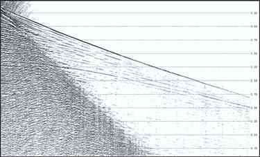
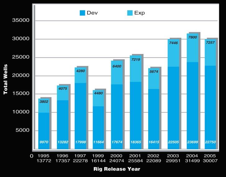
Recent discoveries and statistical analysis of drilling activity between 2003-2005 in the WCSB and Williston Basin can be used to assess current trends and predict future discoveries.The years 2003-2005 were chosen because there is sufficient,relevant public information available and the dataset is a reasonable size.The distribution of exploratory and development well events for the period 1995 to 2005 demonstrates that the years 2003,2004,and 2005 were consistent in levels of activity and results and thus provide an excellent base for additional detail (Figure 1).
STATISTICAL ANALYSIS OF THE BASINS
Between 2003 and 2005,technological advances and high commodity prices influenced the drilling of approximately 72,000 wells.Of these wells,24% are categorized as exploratory (NFW,NPW, DPT,Outpost) and 76% as development. Status distribution has gas dominating 73% of the total completions versus oil at 27%. The area examined includes the Canadian portions of the Western Canada Sedimentary Basin (WCSB) and the Williston Basin.The statistical data was generated using Canadian Discovery’s Exploration & Development Geotechnical Evaluator (EDGE) product.
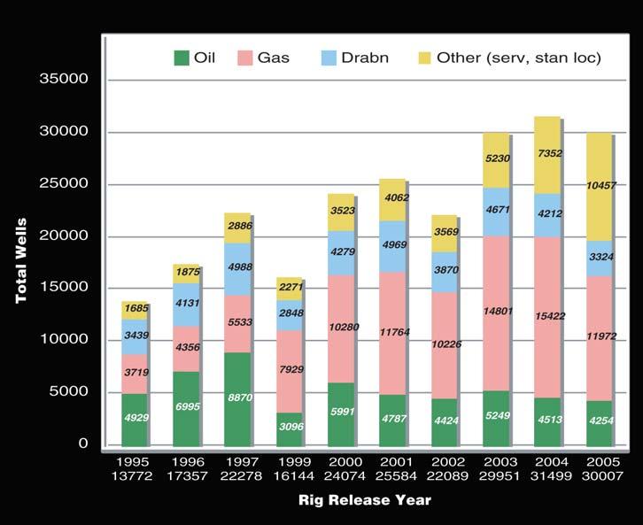
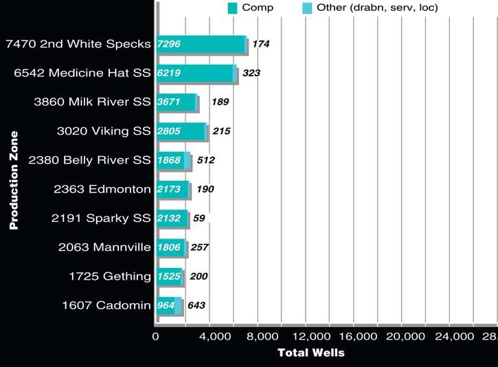
During this 3-year cycle,Cretaceous formations dominate the top 10 producing zones drilled as shown in Figure 2.
Gas-producing wells with the top average initial production values (IP) generally produced from zones stratigraphically
below the Cretaceous.Table 1 lists the top wells with IP rates >12 mmcf/d from the 2003-2005 period.The new conventional discoveries and recent resource plays are delineated by colour.
Oil-producing wells with the top average
Figure 1.Distribution of Wells by Year.
CANADIAN DISCOVERY
initial production values (IP) produced from all stratigraphic zones.Table 2
illustrates the top exploration wells with IP rates >400 bopd from the 2003-2005
period.The development wells were removed from this particular table because they were dominated by oil sands-related horizontal development wells.Eight wells, highlighted by orange on this list,are recent Devonian Nisku conventional oil discoveries.
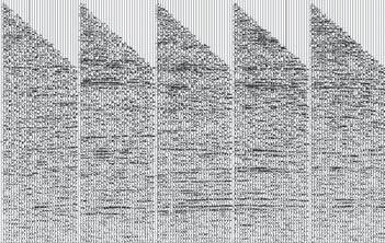
Maps of Rig Release data (Figure 3) do not reveal significant trends with respect to the distribution of exploration and development activity in western Canada from 2003-2005.
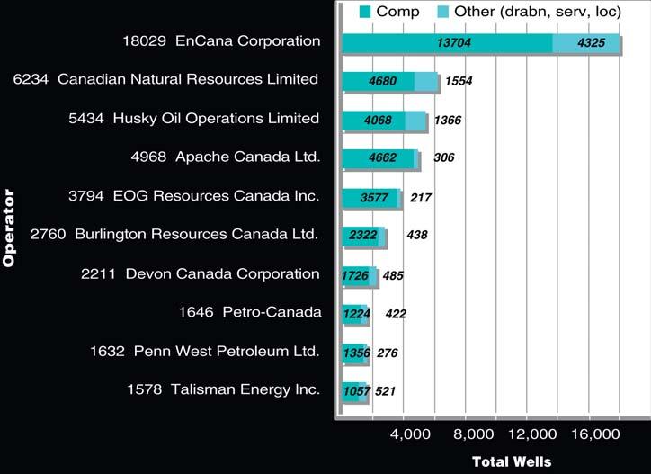
The top operator in Western Canada for the last three years was EnCana,with Canadian Natural Resources,Husky Oil, and Apache Canada the next three dominant players (Figure 4).
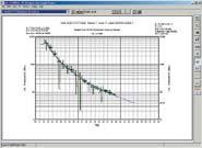
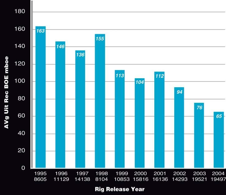
Figure 5 plots the calculated Average Ultimate Recoverable BOE (data from xi technologies inc.) versus the RR year.This graph illustrates that over the last 10 years the average decline is 9.7%.Without question,the average size of pools,in terms of both numbers of wells and recoverable
(Continued on page 35...)
Figure 2.Distribution of Wells by Production Zone.
Table 1.Wells with IP rates > 12 mmcf/d
Supporting the development of natural energy resources
effective expertise
RPSEnergy is an international consultancy providing support and advice on the development of natural resources,the management of the environment and the health & safety of people.
(...Continued from Page 33)
reserves,is shrinking.The necessity to achieve economic production from deeper
and less porous reservoirs has significantly increased production costs and operators are being pressured to maintain both daily
production and reserves in face of declining local and world reserves.
(Continued on page 36...)
Global Reach
Wellsite Geologists required for Canadian and International projects
Apply your geological experience and education to a broader range of projects in Canada and around the world.
As one of the largest Energy consultancies in the world,RPS Energy is breaking new ground and expanding our wellsite geology team.
As a vital member of our wellsite team,you will possess good oral and written communication skills,be well organized,able to provide wireline logging quality control supervision and geological advice to the oil companyrepresentatives.
If you are looking for an excellent rate,interesting projects and continuous work,either locallyor around the world,please contact barkleyl@rpsgroup.com or sayg@rpsgroup.com
Table 2.Exploration Wells with IP rates > 400 bopd.
(...Continued from Page 35)
DISCOVERIES
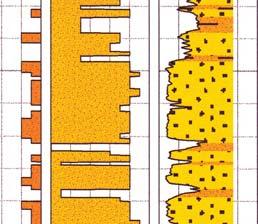
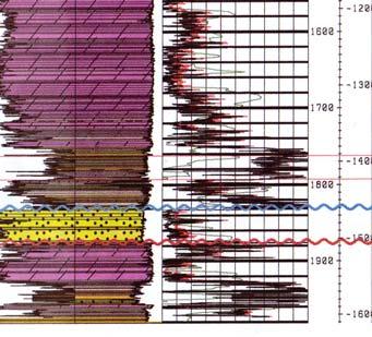
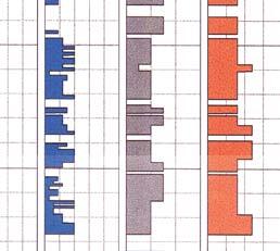
16 WAYS TO IDENTIFY BYPASSED PAY FROM DST DATA
(More advanced, for those “comfortable” with DST charts) Oct. 11 - 12, 2006
HYDRODYNAMICS SEMINAR
(Oil & Gas Finding Aspects) Dec. 4 - 7, 2006
PRACTICAL DST CHART INTERPRETATION
(Thorough Basic Course) Jan. 29 - Feb. 2, 2007
In-house courses available. For course outline visit: www.hughwreid.com
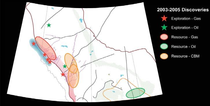
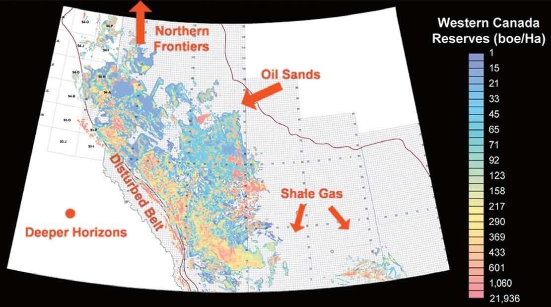
Present exploration in Western Canada is divided between conventional discoveries and resource play developments.During 2003-2005,recent conventional discoveries can be categorized as those associated with the disturbed belt areas and those targeting “deep” horizons.These include Monkman,Lynx,Solomon,Tay River,and Cabin Creek along the Disturbed Belt trend and Pembina and Mega-Venus within the deep Devonian.The unconventional resource play developments are the Deep Basin Tight Gas plays at Cutbank Ridge, Leland,Groundbirch,and Sundown and the Coalbed Methane (CBM) plays at Oberlin, Corbett Creek,and throughout Southern Alberta.Development of a conventionalstyle resource play is in the ViewfieldSinclair trend in the Williston Basin.All of these plays and other recent activity are highlighted in Canadian Discovery Digest Exploration Reviews or CEO activity overviews (www.canadian discovery.com).
Figure 6 illustrates selected conventional discoveries and resource play developments.Exploration gas plays are distributed along the disturbed belt,where
high risk and high reward prospects occur. Exploration oil plays focus on deeper Devonian targets.In terms of resource plays,gas is found within the Deep Basin Tight Gas area,oil is the target in the Williston Basin,and CBM plays occur across central and southern Alberta.
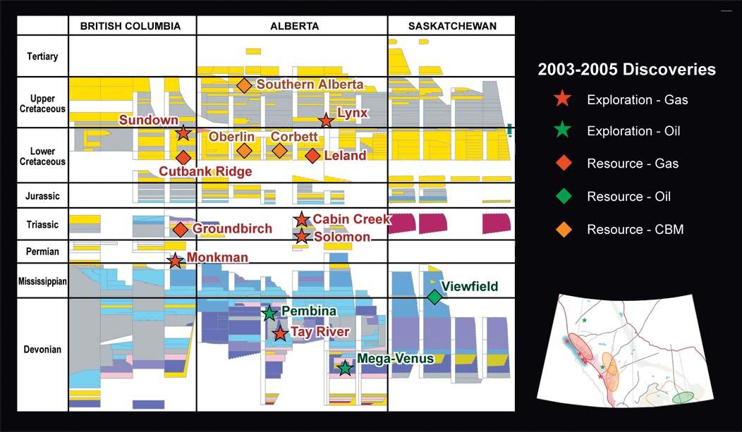
Highlighting these same plays on a stratigraphic chart shows that the distribution is not limited to geological Eras or provinces.
WHERE DO WE GO FROM HERE???
Where do we go from here? The data from the 2003 to 2005 discoveries suggest that operators can continue to exploit their own respective niches,but can also expand their horizons.With high commodity prices,mature areas will remain economic, even in the face of smaller pool sizes and more costly drilling and completion programs.Unconventional plays should also be considered as part of a long-term strategy as they provide consistent additional reserves and production.
Figure 8 illustrates the trends of recoverable hydrocarbon reserves based on drilling over the past ten years.The
Figure 3.Well Rigs released by year.
‘sweet spots’ are highlighted in orange and reds and point to areas where success has been achieved.Explorationists should utilize this type of trend mapping to highlight areas that are geologically similar but have not had the same results.In those regions,there may be less competition and costs may be lower.Although the risks are higher,the rewards can be substantial.
These under-explored areas exist in all play types.Utilizing the industry’s data resources,explorationists can indeed identify,quantify,and develop programs for future gas and oil recovery.
This review of exploration and development over the past three years points out some key drivers.The
Disturbed Belt play,both in the Mesozoic and Paleozoic sections,illustrates that real gains can be made in production if capital and trained personnel are available.While the Disturbed Belt play tends to be dominated by operators with a history in this play type and large capital budgets, there is opportunity for consortiums of smaller operators to chase similar plays.In this scenario no single operator faces the prospect of being unduly hurt by lack of success and each participant can reap considerable benefits from success.As geophysical operations have become technically stronger,interpretation has become easier and more likely to yield positive results,even for less experienced operators.Consortiums of companies willing to be co-operative rather than purely competitive in certain circumstances could effectively pursue plays such as Tay River.
The rejuvenation of the Beaverhill Lake sand play demonstrates that success can be achieved in stratigraphic intervals and areas that traditionally have been overlooked.Galleon Energy has shown that significant production can be achieved in areas that have similar geological settings to previous discoveries but which were under-explored.
The broadening of ideas,as is the case with Tusk Resources’ play at Mega,is exploration that requires imagination and buy-in from management but where the economic rewards can be substantial.
Resource plays such as shale gas in Saskatchewan are growing,evidenced by large exploration permits in previously undrilled areas at Domremy and Shell Lake. Companies that do not have large historical reserves can accumulate a significant resource base at relatively low cost. Resource plays continue in the Deep Basin where larger companies predominate due to the substantial drilling and completion costs involved.On the other hand, relatively small operators can aggressively pursue CBM plays.
Pure mining of the oil sands is obviously the world of huge capital requirement,however the region between mineable oil and conventionally producible oil holds significant potential for operators that can identify areas where higher grade oil is isolated.Similarly,there are areas available
for exploitation of heavy,less moveable oil, which requires more complex infrastructure and engineering,but which have the potential for significant profitability.
Down-spacing will significantly improve productivity and reserves bases for both gas and oil prospects.Operators should constantly review producing properties for that additional potential while other companies should look for this type of opportunity.Technical development in enhanced oil recovery technologies such as CO2 injection can provide future reserve potential in conventional mature areas.
The wide variety of under-drilled areas, stratigraphic horizons,and conventional and unconventional plays within the WCSB presents opportunity for the combination of diligence,good information sources, technical strength,imagination,and a little luck to add significantly to corporate assets for many years to come.
Figure 6.Locations of 2003-2005 Significant Discoveries.
Figure 8.Trends of Recoverable Hydrocarbon Reserves.
Figure 7.Stratigraphic Occurence of 2003-2005 Significant Discoveries.
Maximum reservoir performance
Want to make the most of your valuable oil and gas reserves?
Roxar’s integrated technology solutions and services help companies of all sizes realize the full economic potential of their oil and gas resources.
• Innovative modeling and simulation software
• Downhole monitoring and control systems
• Reservoir production multiphase metering
• Reservoir and production consultancy
Roxar’s leading-edge technology solutions from reservoir interpretation through to production & process meet the changing needs of users in managing the entire reservoir lifecycle.